

Journal of Urban Design
ISSN: (Print) (Online) Journal homepage: https://www.tandfonline.com/loi/cjud20
The big squeeze: maintaining the green infrastructure role of estuarine foreshores while adapting to sea-level rise
Julian Bolleter, Bill Grace, Nicole Edwards, Sarah Foster & Paula Hooper
To cite this article: Julian Bolleter, Bill Grace, Nicole Edwards, Sarah Foster & Paula Hooper (2022): The big squeeze: maintaining the green infrastructure role of estuarine foreshores while adapting to sea-level rise, Journal of Urban Design, DOI: 10.1080/13574809.2022.2097902
To link to this article: https://doi.org/10.1080/13574809.2022.2097902
Published online: 25 Jul 2022.
Submit your article to this journal
View related articles
View Crossmark data
Full Terms & Conditions of access and use can be found at https://www.tandfonline.com/action/journalInformation?journalCode=cjud20
JOURNAL OF URBAN DESIGN
https://doi.org/10.1080/13574809.2022.2097902

The big squeeze: maintaining the green infrastructure role of estuarine foreshores while adapting to sea-level riseJulian Bolleter , Bill Grace , Nicole Edwards, Sarah Foster and Paula Hooper
The Australian Urban Design Research Centre, University of Western Australia, Perth, Australia
ABSTRACT
A global challenge concerns reconciling population growth and increasing built infrastructure with foreshore ecosystems that are ‘squeezed’ against a rising sea levels, hampering their ability to deliver life-sustaining ecosystem services. This paper tests established sea-level rise strategies – fortification, accommodation, and retreat – using a city-centre adjacent estuarine case study in Western Australia to understand the implications for foreshore ecosystem service provision. The results indicate that some retreat of urban areas will be required, combined with the migration of the foreshore reserves landward, to maintain ecosystem service functions over the longer term.
Introduction
KEYWORDS
Climate change; ecosystem services; sea-level rise; climate change adaptation; green infrastructure
The recent International Panel on Climate Change (IPCC) Sixth Assessment Report warns that climate impacts are ‘now cascading and compounding across sectors and socioeconomic and natural systems’ (IPCC 2022). Climate change is inevitable; Meyer explains, ‘we have already lost the battle to prevent climate change entirely, but the battle to blunt its effects has just begun’ (Meyer 2018). Indeed the IPCC affirm that climate change adaptation is now ‘essential and urgent’ (IPCC 2022). Sea-level rise (SLR) is just one of the myriad effects of climate change that will require broad-scale adaptation of cities and regions. SLR presents significant threats to coastal areas – through permanent inundation, flooding, storm surges, erosion, and saltwater intrusion. At the same time, projections are for coastal populations and economies to increase in the following decades (Hurlimann et al. 2014), compounding the implications of this situation.
The most recent projections from the IPCC are that by 2100 Global Mean Sea Level (GMSL) could rise by 0.5 to 0.9 m under the current plausible global greenhouse gas emissions trajectories (IPCC 2021). However, rises to 1.75 m (due to ice-sheet instability) cannot be ruled out (IPCC 2021). Given historic greenhouse gas emissions alone, seas will continue to rise for centuries. Indeed, over the next 2000 years, the global mean sea level will rise by 2 to 3 m if warming is limited to 1.5°C, 2 to 6 m if limited to 2°C and 19 to 22 m with 5°C of warming (IPCC 2021). Ocean, estuarine and river foreshore planning will need to adapt as this situation unfolds over centuries.
CONTACT Julian Bolleter julian.bolleter@uwa.edu.au©
UK Limited, trading as Taylor & Francis Group
2022 Informa
The consequences for both ecosystems and human populations are alarming. At least 10% of the global population lives within 10 m of the current sea level, with scarce resources in many developing countries stymying adaptation efforts (Hindsley and Yoskowitz 2020). Projections also indicate significant losses in the environment. By 2050, SLR (and SLR-induced erosion) will destroy approximately 3,000 to 3,500 km2 of coastal ecosystems depending on the emission scenario (Paprotny et al. 2021).
The ‘big squeeze’
Planners commonly propose fortification, accommodation and retreat responses to the threat of SLR. Nonetheless, a conundrum remains about how planners should reconcile rapid population growth and increases in built infrastructure with foreshore ecosystems which are being squeezed ‘against a rising sea, limiting their ability to provide the lifesustaining services upon which human health and well-being depend’ (Hindsley and Yoskowitz 2020; Lindsey et al. 2008). The ‘squeeze’ is partly due to the disparity between the static quality of the built environment and the dynamic nature of coastal, estuarine, and riverine systems. These differing conditions can lead to the degradation of such foreshore ecosystems (Hindsley and Yoskowitz 2020). The scale of this ‘squeeze’ is evidenced by models using the IPCC maximum estimates of SLR for the year 2100 that suggest that salt marshes globally could decline in area by up to 45% (Craft et al. 2009). This situation is worrying because, in comparison to their limited extent (less than 4% of the Earth’s surface), such coastal ecosystems ‘provide disproportionately more benefits for human well-being than non-coastal regions’ (Barbier et al. 2011; Hindsley and Yoskowitz 2020; Lindsey et al. 2008).
One way of partially preventing such a calamitous outcome is allowing foreshore ecosystems to migrate inland to compensate for accelerated SLR (Craft et al. 2009). However, this can only happen if there is enough accommodation space to allow a retreat of urban areas, a solution which is generally unpalatable for affected communities (Paprotny et al. 2021).
This paper addresses the globally significant interrelated challenges of managing SLR and ecosystem service (ESS) provision in this worrying context. In a localized case study encompassing an estuarine system and the adjacent city centre of Perth (the capital city of Western Australia), the paper explores the degree to which fortification, accommodation, and retreat responses to recent projections for SLR can protect or even enhance, ESS provision. This paper recognizes that while SLR is a global issue, it has significant local consequences. Therefore, for ‘successful adaptation to take place, local action is critical’ (Hindsley and Yoskowitz 2020).
The paper is structured in the following way. First, the conventional responses to SLR and the case study site are introduced. Subsequently, the methods section sets out the research question and assumptions regarding future water levels used to test fortification, accommodation, and retreat strategies. Next, the ESS provision of the strategies with respect to different water levels is set out in the results section. The subsequent discussion section discusses the implications of the various SLR responses for ESS provision. Finally, the broader implications of the findings for both policy and the planning disciplines are tabled.
2 J. BOLLETER ET AL.
Background
The threat posed by SLR is well-known and established planning responses to SLR comprise fortification, accommodation and retreat (Hurlimann et al. 2014; Stephenson and Turner 2013). However, complex challenges bedevil all responses.
Fortification responses to SLR
Hard engineering responses to SLR involve the controlled disturbance of natural processes using built structures. These structures form artificial boundaries which interrupt the landscape’s ‘natural flow and continuity’ (Stephenson and Turner 2013, 16). Fortification responses to SLR typically take the form of sea walls, embankments and dikes (Kellett, Balston, and Western 2014), often deployed in conjunction with beach replenishment to combat increased erosion in adjacent areas.
Fortification is the most accepted response to SLR (Grace and Thompson 2020), and political pressure to construct defences escalates as the value of at-risk built assets increases (Abel et al. 2011). However, issues plague such coastal fortifications.
Fortifications such as seawalls can result in the erosion of wetlands (for instance) in adjacent areas and seaward of the fortifications (Nordenson, Seavitt, & Yarinsky, 2010). This loss of these wetlands diminishes biodiversity (plants, invertebrates, fishes, and birds), coastal protection, and water quality protection (Nordenson et al., 2010). In addition, coastal defences constructed in one area tend to deflect erosion to other sites, causing other residents to campaign for coastal protection, locking the system onto an expensive and irreversible trajectory (Abel et al. 2011).
Moreover, fortifications are extremely expensive, and often there are no apparent means for funding extensive hard engineering responses. Indeed, the current political impasse over increasing tax rates and high public debt levels pose significant difficulties in securing the required investment (Gandy 2014).
Also, when such SLR fortifications fail, a catastrophic inundation can endanger a metropolitan region and the broader economy (Gandy 2014). Worryingly, fortifications against SLR often provide a false sense of security to communities at risk from flooding. Historically, public faith in flood barriers, seawalls, and other coastal defences has contributed to the clustering of development in areas at most significant risk, which compounds the situation (Bowering 2014; Gandy 2014). Moreover, this strategy works against the well-established belief that density increases should be avoided within and adjacent to coastal risk areas (Grace and Thompson 2020). Indeed, uncertainty about governments’ future policies stimulates urban development reflecting the ‘build while you can’ sensibility (Abel et al. 2011, 284). This is concerning because fortifying vulnerable areas in response to SLR will likely be futile in the longer term (Kellett, Balston, and Western 2014), given the projections that sea levels will rise for centuries (Grace and Thompson 2020). While coastal fortifications can protect areas (in the short to medium term) from SLR, flooding from intense rainfall events can also build up on the landward side of coastal fortifications. This situation can require pumping to remove water if sizable areas of the enclosed zone are below the ocean or river level during an event (Cooper and Lemckert
JOURNAL OF URBAN DESIGN 3
2012). This issue is worrying as the warmer temperatures associated with climate change may make small-scale convective systems more frequent in coastal areas, producing micro-bursts of intense rainfall (Cooper and Lemckert 2012).
Accommodation responses to SLR
In contrast to fortification strategies, accommodation responses to SLR accept a degree of flooding and aspire to minimize the associated damage. Planned adaptation involves developing pre-emptive actions to counter possible environmental changes (Cooper and Lemckert 2012, 1). Accommodation strategies can comprise new design criteria for regulators to introduce as the sea level rises. These can include provisions for water pumping (Cooper and Lemckert 2012), flood gates on buildings, elevated floor levels, moveable buildings, and building designs that factor in periodic inundation of the lower floors (Kellett, Balston, and Western 2014).
Moreover, accommodation strategies can also increase the area of planting and permeable surfaces within a city that absorbs water, reducing stress on infrastructure and filtering contaminants before reaching rivers or oceans (Stephenson and Turner 2013 ). These can be deployed in conjunction with strategies to revegetate foreshore environments to reduce the impact of erosion (Grace and Thompson 2020 ).
Retreat responses to SLR
This strategy acknowledges that SLR will result in the longer-term loss of foreshore land; therefore, a planned withdrawal is needed (Kellett, Balston, and Western 2014). This approach can involve moving transportable buildings, demolishing unserviceable buildings, and rezoning adjacent urban areas as foreshores to allow the landward migration of foreshore landscapes (Kellett, Balston, and Western 2014). Retreat strategies often include restrictions on the development of low-lying land, a situation that can be controversial and divisive (Hurlimann et al. 2014). While retreat may be the only viable option in the longer term, its implementation is complex.
A retreat is almost always an unpopular policy as anxious communities generally advocate for a traditional fortified response (Gandy 2014). Moreover, a shared experience has been a backlash from coastal communities towards managed retreat policies, raising concerns regarding government liability for property loss (Kellett, Balston, and Western 2014). Nonetheless, compensation and land swaps (coastal for inland) can partially alleviate community hostility (Abel et al. 2011).
The planning regulations guiding retreat strategies are complicated. Such policy requires mechanisms for changing the rules as the sea level rises over time (Grace and Thompson 2020). For example, policy makers may grant development approval in vulnerable zones on the proviso that when the sea rises to a pre-specified distance from a dwelling, the owner transports or demolishes it and vacates the property (Abel et al. 2011).
4 J. BOLLETER ET AL.
The case study: Perth water
Responses to SLR will be required to adapt Australia’s coastal, estuarine, and riverine regions to climate change. For example, an estimated 160,000 to 250,000 Australian properties are at risk of coastal flooding with a sea-level rise of 1 m by the end of the century (Australian Academy of Science 2021). Indeed, 85% of Australia’s population resides in often vulnerable coastal areas due to its favourable climate, beaches, water sports, biodiversity, existing infrastructure, and economic opportunities (Abel et al. 2011).
A microcosm of this situation is Perth Water (also known by its indigenous name Buneenboro), a sizable estuarine water body on the Swan River (or Derbarl Yerrigan) at the foot of Perth’s central business district1 (Figure 1). Encircling Perth Water are generous, City Beautiful movement inspired, foreshore reserves (Summers 2008). Perth’s residents principally utilize Perth water’s foreshores for active and passive recreation and significant public events. The foreshores combine to form the Central Perth Regional Parklands (CPRP) system that broadly defines the study area of this paper.
Due to Perth Water’s foreshores reclamation from the river in the nineteenth and twentieth centuries, successive governments have had to fortify these areas with sea walls and embankments that typically sterilize the otherwise fecund intertidal zone. Indeed, fortified sea walls and rock revetments make up approximately 75% of the total edge of Perth Water (Figures 2, 3). However, despite fortification, these low-lying foreshore reserves and some adjacent urbanized areas are threatened by projected SLR.

JOURNAL OF URBAN DESIGN 5
Figure 1. Perth water, surrounding CPRP, and study areas. Aerial photo courtesy of Nearmap aerial imagery.

Figure 2. Perth water edge types plan. Fortified sea walls and embankments are the predominate edge condition.
The Central Perth Regional Parklands
Perth’s Capital City Planning Framework incorporates the foreshores of Perth Water into the CPRP as a ‘green infrastructure network, delivering a wide range of ESS’ and an ‘essential element to the identity, liveability and ecology of the city’ (Department of Planning & Western Australian Planning Commission 2013, p. xi). This green infrastructure vision for the Central Perth Regional Parkland system also resonates with Perth’s overarching planning document ‘Perth and Peel@3.5 million’ (Department of Planning Lands and Heritage 2018), the State Planning Policy 2.10, which concerns the Swan and Canning River system (Western Australian Planning Commission 2005), the ‘Healthy Rivers Actions Plan (Swan River Trust 2006), the Swan River Protection Strategy (Department of Parks and Wildlife 2015), the ‘Urban Design Framework’ for central Perth (City of Perth 2010), and now dated (yet informative) planning such as ‘Riverplan’ (Government of Western Australia 2004). Recent policy documents which aspire to ‘rehabilitating, protecting and deepening the understanding of Perth Water Buneenboro’s natural environment’ (Department of Biodiversity Conservation and Attractions 2020b) also encapsulate this green infrastructure role. While Western Australia has statutory State Coastal Planning Policy Guidelines (Western Australian Planning Commission 2013) and related documents, they pertain to coastal rather than riverine or estuarine foreshores.
The importance of the ESS the CPRP delivers will only grow as the residential population of central Perth increases (Department of Planning & Western Australian Planning Commission 2013). Reconciling ESS provision with SLR will be crucial for central Perth’s
6 J. BOLLETER ET AL.

JOURNAL OF URBAN DESIGN 7
Figure 3. Perth water typical edge type sections.
ongoing liveability and resilience. Indeed, as Nature Conservancy Lead Scientist Robert McDonald explains, ‘the most successful cities in the twenty-first century will do the best job of protecting the ESS on which they depend’ (McDonald 2015, 238). In addition, the CPRP is crucial to Perth’s place identity (Department of Planning & Western Australian Planning Commission 2013). Central Perth would lose its essential, defining characteristic (Cooper and Lemckert 2012) and an integral part of Western Australian culture without its generous foreshores.
Given the readily apparent importance of the CPRP’s ESS provision, this study poses the research question:
To what degree can fortification, accommodation, and retreat responses to SLR protect ecosystem service provision in a highly urbanized estuarine setting?
Methods
The research question is explored through a ‘projective design’ exercise (Swaffield and Deming 2010) that examines, in broad terms, the likely effects of strategies for fortification, accommodation, and retreat on ESS provision in the CPRP. The study includes two specific areas of parkland. Langley Park is adjacent to the Perth Central Business District (Figure 4) and Sir James Mitchell Park on the South Perth foreshore (Figure 5). These study areas are typical of the CPRP, and the findings are generalizable to this broader condition.

8 J. BOLLETER ET AL.
Figure 4. Langley Park study area.

SLR layers
The analysis comprises two primary SLR layers. The first is an increase of up to 0.56 m to sea levels at Fremantle (downstream from the case study site) for 2090 based on an optimistic RCP2.6 scenario of net negative CO2 emissions (McInnes et al. 2015). The second is an increase of up to 0.84 m to the sea levels at Fremantle based on a worstcase scenario for 2090 of very high CO2 emissions (RCP8.5) (McInnes et al. 2015). These are broadly commensurate with projected global mean sea levels in recent IPCC reporting for Shared Socioeconomic pathways 1.9 and 8.5 (IPCC 2021). Also included in the study is a low-likelihood layer of 1.75 m which factors in ice-sheet instability under for Shared Socioeconomic pathways 8.5 (IPCC 2021).
These both have been modelled in Rhino 7 (Robert McNeel and Associates 2022) and mapped using the Coastal Risk Australia portal (FrontierSI & NGIS, 2021) with a + 0.7 m nominal highest astronomical tide typical of the region (Ozcoasts 2017), resulting in the +1.26 m WL and +1.54 m WL utilized in the analysis. However, readers should note that flood events could result in much higher periodic water levels. Indeed, the Department of Water and Environmental Regulation has adopted a + 2.38 m level to manage 1 in 100year floods (Department of Water and Environmental Regulation 2022). Nonetheless, this level is not included in the analysis as such events are only episodic.
Subsequently the two SLR layers were intersected with a public open space layer to identify the area of the CPRPs system that this combination of events would threaten. Although referred to here as distinct scenarios, they can also be considered stages in the progression of sea level rise over time.
JOURNAL OF URBAN DESIGN 9
Figure 5. Sir James Mitchell Park study area.
A framework for ecosystem service assessment
A conceptual framework was developed to assess ESS provision concerning SLR adaptation strategies.2 The framework assessment criteria and measures were derived from the literature/evidence base and developed in response to the local riverine and estuarine landscape (i.e., study area) and its functions. The ESS factors considered included cultural services that help promote key community outcomes (i.e., physical activity, mental health); and regulating services for water quality and mitigating flood risk (Department of Planning & Western Australian Planning Commission 2013). Other essential ecosystem services are recognized, e.g., provisioning or supporting; however, they are outside the scope of this necessarily brief paper. The ESS framework and the related assessment criteria are below (Table 1).
Cultural ESS assessment
The following criteria were developed to assess cultural ESS provision. Firstly, physical health: Foreshore areas are popular locations for physical activity in Perth, with users prepared to travel considerable distances to access a river or beach to engage in physical activity (McCormack et al. 2006). Indeed, research has correlated public open space that allows access and water views with increased physical activity in Perth adults (Giles-Corti et al. 2005; World Health 2019). This finding is consistent with evidence reviews and a meta-analysis that emphasized the recreational benefits of blue space for water-based activities and river frontage for walking, running and cycling (Völker and Kistemann 2011)
Table 1. Caption: Ecosystem service assessment. This table defines the assessment criteria for each ecosystem service. These assessment criteria are based on existing foreshore conditions on the Swan River.
Ecosystem service
Cultural ESS
Physical health (land-based)
Physical health (water-based)
Mental health
Regulating ESS
Water quality
Mitigating flood risk
Assessment criteria
Foreshores have substantial width to accommodate small ovals (e.g., for junior football) and are level and significantly above water level to reduce the likelihood of regular flooding.
Foreshores allow easy access to water via gentle gradient to the water’s edge and limited elevation drop to water level (e.g., for swimming or canoeing)
Foreshore and intertidal areas are generous, have a gentle gradient and endemic wetland edge treatments to support biodiversity, which in turn provides mental health benefits
Foreshore and intertidal areas are generous, have a gentle gradient and wetland edge treatments which improve water quality through oxygenation and filtering sediments, pollutants, and nutrients
Foreshore and intertidal areas are generous, have a gentle gradient and wetland edge treatments which soak up floods and storm surges, and limit erosion
Measures for optimal provision of ESS
Foreshore width > 50 m
Foreshore >1 m above mean water level
Foreshore is predominately flat and turfed
Foreshore gradient to water’s edge <25%
Intertidal zone gradient <25%
Foreshore width >50 m
Foreshore gradient to water’s edge <25%
Intertidal zone gradient <25%
Wetland edge treatments
Foreshore gradient to water’s edge <25%
Intertidal zone gradient <25%
Wetland edge treatments
Foreshore width >50 m
Foreshore gradient to water’s edge <25%
Intertidal zone gradient <25%
Wetland edge treatments
10 J. BOLLETER ET AL.
and that residing closer to blue space correlated with significantly higher levels of physical activity (Georgiou et al. 2021). Typically, water-based recreation requires a shallow gradient to the water’s edge and intertidal zone and a limited elevation drop between the predominant foreshore and the mean water levels. Foreshore parks such as Langley Park also are used for active team sports that require generous expanses of level ground to accommodate ovals.
Secondly, mental health: Exposure to green and blue spaces is essential for restoration and mental well-being (Georgiou et al. 2021; Wood et al. 2017). Consistent with a recent systematic review (Georgiou et al. 2021), local research has shown that water and birdlife are strongly associated with positive mental health benefits (Francis et al. 2012). Green and blue spaces are also important sites for social interaction, positively impacting mental well-being (Georgiou et al. 2021). Moreover, research has shown that green space users’ psychological benefits rise in concert with levels of species richness (Fuller et al. 2007). These mental health benefits require riverine foreshores to have a substantial width and intertidal areas with gentle gradients to support fecund wetland ecologies.
Regulating ESS assessment
The SLR strategies were assessed with respect to their effect on various regulating ESS by applying the following criteria: Firstly, water quality: reed beds and other wetland growth can act to improve water quality through natural oxygenation (Hoyer et al. 2011), and act as a bio-filter to remove sediments, pollutants and nutrients (Craft et al. 2009; Stephenson and Turner 2013).
Secondly, mitigating flood risk: There is increasing recognition of the benefits of ‘soft protection’ provided by wetland environments to soak up floods and storm surges and protect adjacent infrastructure and urban development (Bowering 2014). Creating wetlands at sites susceptible to coastal erosion is becoming an increasingly accepted strategy for foreshore erosion protection (Gandy 2014). To provide these regulating ESS, foreshores must have substantial width, shallow gradients in the foreshore and intertidal areas and wetland ecologies.
Results
Table 2 outlines the core results. The figures show that until water levels consistently reach +1.26 m above the current datum, adaptation strategies that demineralize the CPRP’s currently fortified edges could increase some ESS provision. However, over the longer term and under a + 1.54 m increase, retreat strategies (particularly in the Langley Park study area) will be essential in maintaining a foreshore green infrastructure network.
The following section visualizes the fortification, accommodation, and retreat strategies for adapting the CPRP foreshores to SLR in relation to different water levels.
Denial (‘do nothing’)
In a ‘do nothing’ response to SLR, across all the CPRP, approximately 60% will be periodically inundated under +1.26 m WL (at highest tide) and approximately 80% under a combination of +1.54 m WL (at highest tide) (Figure 6).
JOURNAL OF URBAN DESIGN 11
Table 2. ESS delivery for the study areas comparing different SLR adaptation strategies with projected water levels. The retreat strategy- averaged across all sites, yields the greatest ESS. Each ESS fully achieved scored one point, with a maximum possible score of 5. Langley Park
Physical
Physical
Mental
Regulating ESS +1.26m
Water
Mitigating
Cultural ESS at +1.54m WL
Physical health
Physical
Regulating ESS at +1.54m WL
Water
Mitigating
Without a fortify, accommodate, or retreat strategy in the Langley Park study area, a WL of between +1.26 m and +1.54 m will see the foreshore reclaimed mainly by the river, initially during extreme events, eventually permanently. This situation will result in a substantial decrease in cultural ESS provision (Figure 7). This situation relates to physical
Sir
Denial FortificationAccommodation Retreat
Sir James Mitchell Park Langley Park
James Mitchell Park Langley Park Sir James Mitchell Park Langley Park Sir James
Mitchell Park
Cultural ESS at +1.26m WL
health (land-based)0.2510.75100.50.250.5
health (water-based)01000.5111
health00.25000.75111
WL
quality00001111
flood risk from the river 00.750.50.750.25111 Total ESS 0.25 3 1.25 1.75 2.5 4.5 4.25 4.5
(land-based)0100.7500.2511
health00000.5111
health (water-based)00.75000111 Mental
quality00000.5111
from the river 00.500.50111 Total ESS 0 2.25 0 1.25 1 4.25 5 5 12 J. BOLLETER ET AL.
flood risk

Figure 6. Predicted water levels (WLs) and implications for the CPRP system. The 1.26 m WL relates to 0.56 m SLR plus a 0.7 m high tide, and the 1.54 m WL relates to 0.84 m SLR plus a 0.7 m high tide. Also included is a low-likelihood layer of 2.45 m WL (1.75 m SLR plus a 0.7 m high tide) which factors in icesheet instability under for Shared Socioeconomic pathways 8.5. Water levels shown are indicative only.
JOURNAL OF URBAN DESIGN 13
health (land-based) due to a lack of space. Moreover, it will compromise regulating ESS, such as flood risk mitigation (the foreshore will cease to provide physical protection to adjacent urbanism and infrastructure from floods and storm surges). At the same time, regulating ESS such as water quality protection (that requires wetland environments not found in the current study areas) is not likely to improve in a denial ‘do nothing’ SLR response – at least in the short term.
Due to a steeper gradient and more generous width, the Sir James Mitchell Park study area will be less affected; however, the river will flood the existing foreshore, path network, car park and boating facilities ( Figure 8 ). Reflecting this existing cultural ESS functions such as physical health (land and water-based) will need to migrate inland.
Fortification
Fortification strategies could take the form of an engineered bund and seawall running along the present-day alignment of Riverside Drive, in the Langley Park study area and along the existing foreshore in the Sir James Mitchell Park study area.
In a + 1.2 m WL situation, such a structure in the Langley Park study area should maintain the current area of the foreshore (Figure 9). This foreshore should continue to provide ESS concerning physical health ESS (land-based) although access to the river for water-based activities will be hampered. In a + 1.54 m WL situation, these fortifications are likely to fail for two reasons. Firstly, groundwater on the landside will rise in concert with the river. Secondly, if stormwater collects behind the bund in an extreme rainfall event (on the landward side), this will necessitate mechanical pumping. This situation would compromise the ESS provision of the Langley Park study area in respect of physical health (land and water-based) and mental health (due to a lack of endemic foreshore areas), and the mitigation of flood risk (the foreshore will cease to provide physical protection from floods and storm surges). Moreover, ESS, such as water quality protection, requires wetland environments not part of a fortified SLR response.
Fortifications in the Sir James Mitchell Park study area will likely be more effective than in the Langley Park study area; however, the flooding issues on the inshore side of the fortification remain to some degree (Figure 10). Nonetheless, fortifying the river’s edge will degrade physical health (water-based) ESS functions due to compromised access to the river.
Accommodation
Accommodation strategies in the study areas could include new building structures designed to allow for periodic flooding of the lower levels and increased wetland planting in the foreshore reserve, reducing the impact of flood events and filtering contaminants. For example, in the Langley Park study area, a + 1.26 m WL situation, such a reconfigured foreshore should be able to continue to provide physical and mental health ESS. However, there would be a shift towards more passive recreation (such as walking) from active recreation (such as ball sports) which have more extensive spatial requirements. Moreover, ESS provision in relation to water quality protection and mitigation of flood risk should increase with the introduction of wetland environments. However, this level of accommodation offers only a temporary reprieve, as in a + 1.54 m WL situation (which is
14 J. BOLLETER ET AL.

Figure 7. Langley Park study area foreshore- denial ‘do nothing’ scenario. Such a response to SLR will lead to a significant reduction in ESS provision. Water levels shown are indicative only.
JOURNAL OF URBAN DESIGN 15

Figure 8. Sir James Mitchell foreshore- denial ‘do nothing’ scenario. Due to a steeper gradient and generous reserve ESS will be able to migrate inland. Water levels shown are indicative only.
16 J. BOLLETER ET AL.
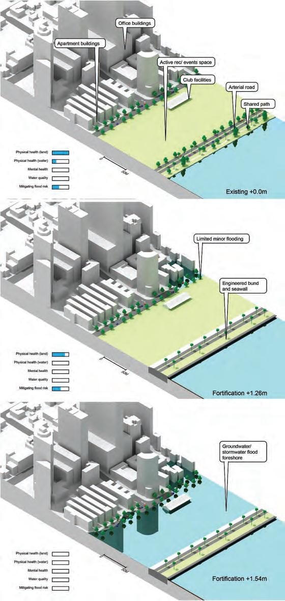
Figure 9. Langley Park study area – fortification. Fortifications generally maintain existing ESS at lower water levels; however, this will cease to be the case at the higher levels. Water levels shown are indicative only.
JOURNAL OF URBAN DESIGN 17

Figure 10. Sir James Mitchell foreshore- fortification. Fortifications will likely diminish the provision of ESS. Water levels shown are indicative only.
18 J. BOLLETER ET AL.
eventually inevitable), the reconfigured Langley Park foreshore environment will be substantially underwater, which will reduce such regulating ESS provision accordingly (Figure 11).
In the Sir James Mitchell Park study area (Figure 12), increased wetland planting in the foreshore reserve will increase ESS provision in relation to water quality protection and mitigation of flood risk. Moreover, such a reconfigured foreshore should be able to continue to provide physical (water-based) and mental health ESS – however, there would be a shift towards more passive recreation (such as walking) from active recreation (such as ball sports), which has more extensive spatial requirements. Due to the steeper gradient, these ESS should also be able to continue to be provided at the 1.54 m WL.
Retreat
Retreat strategies in the study areas could take the form of rezoning of currently urban land to a foreshore zoning and the subsequent demolition of buildings as they reach the end of their lifespan or become unserviceable. Certain levels of SLR could trigger these activities. This strategy essentially would allow the foreshore reserve to migrate landward as SLR occurs. Due to the foreshore width being largely maintained and the introduction of wetland environments, such a strategy could see ESS such as physical and mental health, water quality protection and mitigation of flood risk be maintained, and in some cases, increased (Figures 13, 14)
The migration of urban areas, associated infrastructure, and the foreshore reserve inland with SLR has potentially positive implications for providing ESS over the longer term. As the foreshore reserve migrates inland, there is an opportunity to design it as a piece of multifunctional green infrastructure that balances environmental, cultural, technical, and economic priorities. While this may not extend to providing full-size sporting ovals to support the cultural ESS of physical health (land-based), some allowance for active recreation through smaller-size ovals for team sports should be feasible.
Discussion
The results indicate that retreat and, to a lesser degree, accommodation (as an interim measure) responses to SLR will deliver the optimal ESS provision in the CPRP, given the likelihood of substantial SLR.
Accommodation strategies accept a degree of flooding associated with SLR and aim to minimize the damage. In the short to medium term, accommodation strategies such as de-fortifying and revegetating the river’s edges could considerably increase ESS provision, particularly those associated with water quality protection and mitigating flood risk. However, as SLR begins to flood such areas regularly, there will be a loss of foreshore area and a decline in associated ESS provision.
Ultimately, to maintain – and enhance – the CPRP’s ESS role over the longer term, the migration of the foreshore landward with SLR will be required. As the foreshore reserve migrates, it is possible to maintain its width and design it as a piece of multifunctional green infrastructure that balances environmental, technical, and economic priorities
JOURNAL OF URBAN DESIGN 19

Figure 11. Langley Park study area – accommodation. Revegetation of the currently fortified edge could improve ESS provision; however, higher water levels will negate many of these. Water levels shown are indicative only.
20 J. BOLLETER ET AL.

Figure 12. Sir James Mitchell Park study area – accommodation. An accommodation model of adaptation could potentially increase the amount of ESS provided. Water levels shown are indicative only.
JOURNAL OF URBAN DESIGN 21

Figure 13. Langley Park study area – retreat. A retreat strategy could substantially increase ESS provided by the foreshore environment over time. Water levels shown are indicative only.
22 J. BOLLETER ET AL.

Figure 14. Sir James Mitchell Park study area – retreat. A retreat strategy could substantially increase ESS provided by the foreshore environment over time. The water levels shown are indicative only.
JOURNAL OF URBAN DESIGN 23
(Nordenson et al., 2010). In such a model, the adapted CPRPs could provide regulating ESS, water quality protection, mitigating flood risk, and cultural ESS physical and mental health at a level above the existing foreshores.
The political and economic feasibility of sea-level rise adaptation
The retreat of urban areas, and their rezoning as foreshore reserves, will be deeply unpopular with affected landowners and vigorously contested. Indeed, given that areas around the CPRP system have had the highest investment in built form and infrastructure of any area alongside the Swan and Canning Rivers, the state or local government will likely develop fortification strategies to protect these investments instead. Indeed, there is a high likelihood that the fortification of the foreshore will become politicized. In this mode, any state government unwilling to ‘fortify the foreshore’ would likely incur political backlash, reflecting that the expectation for fortification will be exceptionally high in vulnerable areas, such as adjacent to Langley Park (where urban development is ongoing). The desire to fortify and protect these areas is understandable but counterproductive from the perspective of the CPRPs maintaining its green infrastructure and ESS role.
To counter this sentiment, state or local government could incentivize foreshore retreat – at least to a degree – through compensation, land swaps and the provision of well-designed, multifunctional foreshores. In this way, retreat strategies represent much more than ‘deleting’ unviable areas, as Wolff-Plottegg described (In Gandy 2014, 209) but enhancing the CPRP’s liveability and ecological performance through a considered redesign. Moreover, limiting development in these zones will allow a gradual transition from an urban area to a landscaped foreshore.
Government has a critical role in delivering retreat strategies, as this is not a form of climate adaptation that the market will deliver in isolation. A local model for a retreat programme might stem from how many governments deliver traditional transport infrastructure such as freeways. For example, State Government could opportunistically purchase vulnerable lots (presumably at a high cost) and then lease them until a physical retreat is required (Grace and Thompson 2020). In this scenario, the required foreshore reserve would migrate landward as determined by the ‘physical processes’ setback plus additional land required to provide a suitable public reserve (Grace and Thompson 2020). In less planned processes, insurance premiums would become effectively unaffordable due to flood risks, and many properties could be effectively uninsurable and therefore undesirable (Australian Academy of Science 2021). Ultimately, infrastructure will fail due to the rising water level (e.g., flooding sewerage pump stations), which will force building evacuation. However, how these process could unfold in this location, which contains some of Perth’s currently most expensive real estate, is open to conjecture.3 Nonetheless, state and local governments must curtail ongoing urban development in these zones to avoid compounding these issues when the time for retreat inevitably arrives.
Unfortunately, most current responses to climate change in Australia are reactionary, not preventive actions. Indeed, concern about what may happen in 2100 (for instance) is not foremost in the minds of political leaders when prioritizing where to spend public funds. Accordingly, current planning for Perth Water (Department of
24 J. BOLLETER ET AL.
Biodiversity Conservation and Attractions 2020b) appears to defer the prickly issue of a possible retreat to a prospective medium to long-term strategy for foreshore management (Department of Biodiversity Conservation and Attractions 2020a).
The WA State Government enshrined their response to climate change in the longawaited WA Climate Policy (Department of Water and Environmental Regulation 2021). However, the WA Climate Policy is weak on concrete actions and falls distinctly short of explaining how place-based adaptation, such as Perth Water requires, should occur. This state of affairs is concerning because, as the IPCC warns us, delay in implementing adaptation will ‘impede climate-resilient development and result in more costly climate impacts and a grander scale of future adjustments’ as risks ‘cascade and compound’ (IPCC 2022).
Broader implications
So, what are the implications of these findings for the planning disciplines? In essence, navigating SLR and ESS requires a shift in mentality on several fronts. First, urban designers and planners must become more process-oriented in areas subject to SLR. It is immensely complicated to reconcile ecological systems with urban systems (Weller 2008), as the ‘big squeeze’ challenge necessitates. The reason is fundamental: ecological systems – such as an estuarine system – are dynamic and organic, whereas urban systems are mechanistic, standardized and generic (Weller 2008, 254). To navigate this gulf and deal with unpredictable timeframes, planners need to think about rules that allow urban projects to adapt to SLR and flooding over time, for instance, certain water levels triggering different design/ planning regimes (Grace and Thompson 2020). The result is less New Urbanism’s ‘utopia of form’ and more Landscape Urbanism’s ‘Utopia of Process’ (Weller 2008, 253). Scenario planning that allows for essential uncertainties beyond planners’ control is also potentially instructive (Goodspeed 2020). Moreover, the ‘big squeeze’ also necessitates a long-term view, given that the process of adapting the foreshores to SLR will be an ongoing exercise beyond our lifetimes.
Finally, planners will find themselves, in some cases advocating for the removal of buildings and infrastructure rather than the conventional ‘business as usual’ planning and development approaches. How planners can reconcile this with community and client expectations remains an open question. Planners will need to be both deft and wellprepared to engage with communities and clients about SLR adaptation. Indeed, divergent risk perceptions and values, inconsistent information, fear of litigation, and a lack of trust often stymie adaptation efforts (IPCC 2022).
Limitations
Ultimately ESS provision will depend on the detailed design of the various SLR responses, and as such clever design solutions (for example, floating reed-beds) may mitigate some of the ESS provision issues the paper identifies. Moreover, the SLR strategies tabled are indicative and serve as a prompt to the likely issues they will precipitate; they are not intended as detailed design proposals. They also assume a once-off treatment (e.g., fortifying the foreshore with a single structure) rather than repeated attempts at fortification (e.g., fortifying the foreshore with multiple structures over time). Finally, given the paper’s explicit
JOURNAL OF URBAN DESIGN 25
focus on ESS provision, it does not include detail on the costs of building demolition and the resumption of expensive urban land, important as these are. Worthy further research could consider a comprehensive cost-benefit analysis of the different options.
Conclusion
This case study has shown that if planners are to engender estuarine foreshore ESS functions over the longer term, some retreat of urban areas will inevitably be required, and the migration of the foreshore reserve landward.
While in the twentieth century, urban waterfront redevelopment shaped coasts, rivers and estuaries globally (Rigby and Breen 1994), in the twenty-first century (and beyond), these hydrological systems will reassert their power to shape cities (Bolleter 2014, 2015). This paper has considered how this re-assertion can maximize the ESS essential to the case study’s liveability and identity. While the paper is based on alarming projections for SLR, it is predicated on the belief that successful adaptation to SLR could enhance ESS provision in some rare cases. The planning disciplines have a crucial role to play. As Matthew Gandy explains, our thinking around such issues needs to be realistic yet aspirational (Gandy 2014). This paper is directed towards this end.
Notes
1. The area has been of great significance to the region’s indigenous inhabitants for many thousands of years. The Noongar people believe the Swan and Canning River system, the Derbarl Yerrigan, is sacred and was created in the dreamtime by the rainbow serpent ‘Waugal’. The abundant marine and aquatic bird life provided reliable food sources and the existence of a spring provided fresh water (Hughes-Hallet and de Gand 2010).
2. The development of this framework involved expertise in civil engineering, an urban design, landscape architecture and three public health – all drawn from the author team.
3. This presents a strange inversion of the global situation where SLR and flooding tends to disproportionately affect the poor and disposed (IPCC 2022).
Acknowledgments
The authors would like to acknowledge Iwan Isnin and Zoe Myers for their contributions to the research.
Disclosure statement
No potential conflict of interest was reported by the author(s).
Funding
This work was supported by the Western Australian Metropolitan Redevelopment Authority [-].
ORCID
Julian Bolleter http://orcid.org/0000-0002-1514-2007
26 J. BOLLETER ET AL.
Bill Grace http://orcid.org/0000-0002-1305-7466
Sarah Foster http://orcid.org/0000-0002-8624-4908
Paula Hooper http://orcid.org/0000-0003-4459-2901
References
Abel, N., R. Gorddard, B. Harman, A. Leitch, J. Langridge, A. Ryan, and S. Heyenga. 2011. “Sea Level Rise, Coastal Development and Planned Retreat: Analytical Framework, Governance Principles and an Australian Case Study.” Environmental Science & Policy 14 (3): 279–288. doi:10.1016/j. envsci.2010.12.002
Australian Academy of Science. 2021. “The Risks to Australia of a 3°C Warmer World.” www.science. org.au/warmerworld
Barbier, E. B., S. D. Hacker, C. Kennedy, E. W. Koch, A. C. Stier, and B. R. Silliman. 2011. “The Value of Estuarine and Coastal Ecosystem Services.” Ecological Monographs 81 (2): 169–193. doi:10.1890/ 10-1510.1.
Bolleter, J. 2014. “Charting a Changing Waterfront: A Review of Key Schemes for Perth’s Foreshore.” Journal of Urban Design 19 (5): 569–592. doi:10.1080/13574809.2014.943703.
Bolleter, J. 2015. Take Me to the River: The Story of Perth’s Foreshore. Perth: University of Western Australia Publishing.
Bowering, E. 2014. “Adapting to climate-induced Sea Level Rise on the Gold Coast: Lessons from the Netherlands.” Australian Planner 51 (4): 340–348. doi:10.1080/07293682.2014.897637.
City of Perth. 2010. “An Urban Design Framework: A Vision for Perth 2029.” Perth: x. Cooper, J. A. G., and C. Lemckert. 2012. “Extreme sea-level Rise and Adaptation Options for Coastal Resort Cities: A Qualitative Assessment from the Gold Coast, Australia.” Ocean & Coastal Management 64: 1–14. doi:10.1016/j.ocecoaman.2012.04.001
Craft, C., J. Clough, J. Ehman, S. Joye, R. Park, S. Pennings, M. Machmuller, and M. Machmuller. 2009. “Forecasting the Effects of Accelerated Sea-level Rise on Tidal Marsh Ecosystem Services.” Frontiers in Ecology and the Environment 7 (2): 73–78. doi:10.1890/070219.
Department of Biodiversity Conservation and Attractions. 2020a. “Perth Water Buneenboro Action Plan.” https://www.dpaw.wa.gov.au/images/documents/about/policy/Perth%20Water%C2% A0Buneenboro%C2%A0Action%20Plan.pdf
Department of Biodiversity Conservation and Attractions. 2020b. “Perth Water Buneenboro Locality Plan.” https://www.dbca.wa.gov.au/sites/default/files/2021-08/PW%20LOCALITY%20PLAN-PrintAug2021.pdf
Department of Parks and Wildlife. 2015. “Swan Canning River Protection Strategy.” https://swanri vertrust.dpaw.wa.gov.au/images/documents/river_protection_strategy/Swan_Canning_River_ Protection_Strategy.pdf
Department of Planning, & Western Australian Planning Commission. 2013. “Capital City Planning Framework.” https://www.dplh.wa.gov.au/projects-and-initiatives/planning-for-the-future/capi tal-city-planning-framework-2013
Department of Planning Lands and Heritage. 2018. “Perth and Peel @3.5 Million.” https://www.dplh. wa.gov.au/perth-and-peel-@-3-5-million
Department of Water and Environmental Regulation. 2021. “Western Australian Climate Policy: A Plan to Position Western Australia for A Prosperous and Resilient low-carbon Future.” https:// www.wa.gov.au/sites/default/files/2020-11/Western_Australian_Climate_Policy.pdf
Department of Water and Environmental Regulation. 2022. “FPM 1 in 100 (1%) AEP Floodway and Flood Fringe Area.” https://catalogue.data.wa.gov.au/dataset/fpm-100-year-ari-floodway-andflood-fringe-areas
Francis, J., L. J. Wood, M. Knuiman, and B. Giles-Corti. 2012. “Quality or Quantity? Exploring the Relationship between Public Open Space Attributes and Mental Health in Perth, Western Australia.” Social Science & Medicine 74 (10): 1570–1577. doi:10.1016/j.socscimed.2012.01.032. FrontierSI, & NGIS. 2021. “Coastal Risk Australia.” https://coastalrisk.com.au/home
JOURNAL OF URBAN DESIGN 27
Fuller, R. A., K. N. Irvine, P. Devine-Wright, P. H. Warren, and K. J. Gaston. 2007. “Psychological Benefits of Greenspace Increase with Biodiversity.” Biology Letters 3 (4): 390–394. doi:10.1098/ rsbl.2007.0149
Gandy, M. 2014. The Fabric of Space: Water, Modernity, and the Urban Imagination. Cambridge, MA: MIT Press.
Georgiou, M., G. Morison, N. Smith, Z. Tieges, and S. Chastin. 2021. “Mechanisms of Impact of Blue Spaces on Human Health: A Systematic Literature Review and Meta-Analysis.” International Journal of Environmental Research and Public Health 18 (5): 2486. doi:10.3390/ijerph18052486.
Giles-Corti, B., M. H. Broomhall, M. Knuiman, C. Collins, K. Douglas, K. Ng, R. J. Donovan, and R. J. Donovan. 2005. “Increasing Walking: How Important Is Distance To, Attractiveness, and Size of Public Open Space?” American Journal of Preventive Medicine 28 (2): 169–176. doi:10.1016/ j.amepre.2004.10.018
Goodspeed, R. 2020. Scenario Planning for Cities and Regions. Managing and Envisioning Uncertain Futures. Cambridge, MA: Lincoln Institute of Land Policy.
Government of Western Australia. 2004. “Riverplan: An Environmental Management Framework for the Swan and Canning Rivers.” https://library.dbca.wa.gov.au/static/FullTextFiles/925543.pdf
Grace, B., and C. Thompson. 2020. “All Roads Lead to Retreat: Adapting to Sea Level Rise Using a trigger-based Pathway.” Australian Planner 56 (3): 182–190. doi:10.1080/07293682.2020.1775665. Hindsley, P., and D. Yoskowitz. 2020. “Global change—Local Values: Assessing Tradeoffs for Coastal Ecosystem Services in the Face of Sea Level Rise.” Global Environmental Change 61: 102039. doi:10.1016/j.gloenvcha.2020.102039.
Hoyer, J., W. Dickhaut, L. Kronawitter, and B. Weber. 2011. Water Sensitive Urban Design: Principles and Inspiration for Sustainable Stormwater Management in the City of the Future. Hamburg: Jovis. Hughes-Hallet, D., and D. de Gand. 2010. Indigenous History of the Swan and Canning Rivers. Perth: Curtin University.
Hurlimann, A., J. Barnett, R. Fincher, N. Osbaldiston, C. Mortreux, and S. Graham. 2014. “Urban Planning and Sustainable Adaptation to sea-level Rise.” Landscape and Urban Planning 126: 84–93. doi:10.1016/j.landurbplan.2013.12.013.
IPCC. 2021. “Climate Change 2021: The Physical Science Basis: Summary for Policymakers.” https:// www.ipcc.ch/report/ar6/wg1/
IPCC. 2022. “IPCC Working Group II Sixth Assessment Report.” https://www.ipcc.ch/report/ar6/wg2/ Kellett, J., J. Balston, and M. Western. 2014. “Sea-level Rise and Planning: Retrospect and Prospect.” Australian Planner 51 (3): 203–211. doi:10.1080/07293682.2013.808681.
Lindsey, G., J. Wilson, J. Anne Yang, and C. Alexa. 2008. “Urban Greenways, Trail Characteristics and Trail Use: Implications for Design.” Journal of Urban Design 13 (1): 53–79. doi:10.1080/ 13574800701804033.
McCormack, G. R., B. Giles-Corti, M. Bulsara, and T. J. Pikora. 2006. “Correlates of Distances Traveled to Use Recreational Facilities for Physical Activity Behaviors.” International Journal of Behavioral Nutrition and Physical Activity 3 (1): 1–10. doi:10.1186/1479-5868-3-1.
McDonald, R. 2015 Conservation for Cities: How to Plan and Build Natural Infrastructure. Washington: Island Press.
McInnes, K. L., J. Church, D. Monselesan, J. R. Hunter, J. G. O’Grady, I. D. Haigh, and X. Zhang. 2015. “Information for Australian Impact and Adaptation Planning in Response to sea-level Rise.” Australian Meteorological and Oceanographic Journal 65 (1): 127–149. doi:10.22499/2.6501.009.
McNeel, R., and Associates. 2022. “Rhinoceros.” https://www.rhino3d.com/ Meyer, R. 2018. “How to Understand the UN’s Dire New Climate Report.” https://www.theatlantic. com/science/archive/2018/10/how-to-understand
Nordenson, S., and Yarinsky. 2010 On the Water: Palisade Bay. New York: Museum of Modern Art Princeton University School of Architecture. Ozcoasts. 2017. “Australian Online Coastal Information.” http://www.ozcoasts.gov.au/climate/Map_ images/Perth/mapLevel2_North.jsp
Paprotny, D., P. Terefenko, A. Giza, P. Czapliński, and M. I. Vousdoukas. 2021. “Future Losses of Ecosystem Services Due to Coastal Erosion in Europe.” Science of the Total Environment 760: 144310. doi:10.1016/j.scitotenv.2020.144310
28 J. BOLLETER ET AL.
Rigby, D., and A. Breen. 1994 Waterfronts: Cities Reclaim Their Edge. New York: Mc Graw-Hill. Stephenson, and Turner. 2013. From Resistance to Resilience: A New Paradigm of Coastal Cities. New Zealand: Stephenson & Turner.
Summers, L. 2008. “To Boldly Go: Seeing America, Imagining Australia.” Paper presented at the International Planning History Conference, Chicago.
Swaffield, S., and E. Deming. 2010 Landscape Architecture Research. New Jersey: Wiley. Swan River Trust. 2006. “Healthy Rivers Action Plan.” Perth.
Völker, S., and T. Kistemann. 2011. “The Impact of Blue Space on Human Health and wellbeing–Salutogenetic Health Effects of Inland Surface Waters: A Review.” International Journal of Hygiene and Environmental Health 214 (6): 449–460. doi:10.1016/j.ijheh.2011.05.001.
Weller, R. 2008. “Landscape (Sub) Urbanism in Theory and Practice.” Landscape Journal 27 (2): 247–267. doi:10.3368/lj.27.2.247
Western Australian Planning Commission. 2005. “State Planning Policy No. 2.10 Swan-Canning River System.” Perth: Government of Western Australia. https://www.dplh.wa.gov.au/spp2-10
Western Australian Planning Commission. 2013. “State Planning Policy No. 2.6 State Coastal Planning Policy.” Perth: Government of Western Australia. https://www.dplh.wa.gov.au/spp26-coastal-planning
Wood, L., P. Hooper, S. Foster, and F. Bull. 2017. “Public Green Spaces and Positive Mental health–investigating the Relationship between Access, Quantity and Types of Parks and Mental Wellbeing.” Health & Place 48: 63–71. doi:10.1016/j.healthplace.2017.09.002
World Health, O. 2019. Global Action Plan on Physical Activity 2018-2030: More Active People for a Healthier World. Geneva: World Health Organization.
JOURNAL OF URBAN DESIGN 29