
This Australian Urban Design Research Centre (AUDRC) project initially examines existing, proposed and strategic planning in relation to Perth Water and surrounds by various stakeholders, including the City of Perth, City of South Perth, Department of Parks and Wildlife amongst others. In combination with a geospatial and site based analysis this research provides a snapshot of the current planning for, Perth Water. It also reveals that there is substantial consensus that the foreshores of Perth Water should be considered part of a green infrastructure network, and that they are crucial to the identity, liveability and ecology of the city. Given this situation, the project poses the questions - how can the green infrastructure role for Perth Water’s foreshores, as proposed in existing planning, be enhanced at the same time as adapting to projected Sea level Rise (SLR), which mapping shows poses a significant risk to the foreshores and adjacent low lying urban areas?
The rising tide


Reconciling Sea Level Rise with the provision of ecosystem services in Perth Water
1. Introduction
This project poses the questionhow can the green infrastructure role for Perth Water’s foreshores be enhanced at the same time as adapting to Sea level Rise ?
Chapter 1: Introduction
This project initially examines existing, proposed and strategic planning in relation to Perth Water and surrounds by various stakeholders, including the City of Perth, City of South Perth, Department of Parks and Wildlife amongst others (chapter 2). In combination with a geospatial and site based analysis (chapter 3 and 4) this research provides a snapshot of the current condition planning for, Perth Water. It reveals that there is substantial consensus that the foreshores of Perth Water should be considered part of a green infrastructure network, and that they are an essential element of the identity, liveability and ecology of the city.
Given this situation, the project explores the questions - how can the green infrastructure role for Perth Water’s foreshores, as proposed in existing planning, be enhanced at the same time as adapting to projected Sea level Rise (SLR), which mapping shows poses a significant risk to the foreshores and adjacent low lying urban areas? This discussion is carried out in relation to a series of exemplar case study projects, which illustrate three main responses to SLR, fortify, accommodate or retreat (chapter 5). These strategies are spatially tested on the foreshores of Perth Water to understand their implications for the foreshore’s broader green infrastructure functions (chapter 6).
Background
The following section sets out the context of this research, and a definition of the key terms used.
Sea level Rise (SLR)
Seas have already risen by more than 20 cm since 1880, affecting coastal environments around the world. Since 1993, sea level has been rising faster still, at about 3 mm per year (Church & Clark, 2016). SLR is regarded to be caused by a generally warming climate associated with climate change. In turn, the two largest contributions to the observed rise since 1900 are thermal expansion of the oceans, and the loss of ice from glaciers (Church & Clark, 2016).
Sea-level rise poses major risks to lands along most coasts, and to the 600 million people and two-thirds of the world’s major cities that are located in low-lying coastal areas. Climate change means that over time, coastal lands will be progressively more exposed to flooding, permanent inundation, erosion, higher storm surges, and saltwater intrusion. Over this same period, coastal populations and economies are projected to increase (Hurlimann et al., 2014, p. 84). Reflecting this situation, in Australia it is estimated that existing residential buildings with a replacement value of $63 billion would be at risk of inundation from a 1.1m SLR (Abel et al., 2011, p. 281). In turn this reflects that 85% of Australia’s population lives near the coast due to its favourable climate, services, infrastructure, business and job opportunities, scenery, beaches, water sports, fishing and wildlife (Abel et al., 2011, p. 281).
A microcosm of this situation is found in Perth Water. Perth Water is encircled by low-lying foreshore reserves, and some urban areas, which are under threat by the SLR projected for this century. This
situation will be further compounded beyond 2100 as seas will continue to rise for many centuries. With continued growth in emissions, the Intergovernmental Panel on Climate Change (IPCC) has projected a rise of as much as 7 m by 2500, but also warned that the available ice-sheet models may underestimate Antarctica’s future contribution (Church & Clark, 2016). As such, planning for Perth Water will need to continually adapt as this situation plays out over the next centuries.
Ecosystem services
8
One of the main issues posed by SLR in Perth Water is that it threatens the foreshore reserves which are central to Perth’s place identity (Department of Planning & Western Australian Planning Commission, 2013, p. vii). In short Perth’s foreshores are the ‘sine qua non’ for Perth. Without its foreshores, Perth would lose its essential, defining characteristic (J. A. G. Cooper & C. Lemckert, 2012, p. 8) and an integral part of Western Australian culture (GHD, In press, p. 12).
Recognizing this situation ‘The Capital City Planning Framework’ incorporates the foreshores of Perth Water into the ’Central Perth Regional Parklands’ – a ‘green infrastructure network, delivering a wide range of ecosystem services’ and an ‘essential element to the identity, liveability and ecology of the city’ (Department of Planning & Western Australian Planning Commission, 2013, p. xi). As its authors explain:
By enhancing our sense of place the central Perth Regional Parklands will
make central Perth even more memorable for residents and visitors alike (Department of Planning & Western Australian Planning Commission, 2013, p. xi).
This vision for Perth Water, and its foreshores, also resonates with the Perth’s overarching planning document ‘Perth and Peel@3.5 million’ (Government of Western Australia, 2015), the State Planning Policy 2.10 which concerns the Swan and Canning River system (Western Australian Planning Commission, 2005), the ‘Healthy Rivers Actions Plan (Swan River Trust, 2006), the Swan River Protection Strategy (Department of Parks and Wildlife, 2015), the ‘Urban Design Framework’ for central Perth (City of Perth, 2010), and now dated (yet informative) planning such as ‘Riverplan’ (Government of Western Australia, 2004).
The ecosystem services referred to directly in ‘The Capital City Planning Framework’ and others are ‘the components of nature, directly enjoyed, consumed, or used to yield human well-being’ (Mandle & Tallis, 2016, p. 17; McDonald, 2015, p. 10).
Ecosystem services can be broken down into:
• ‘Provisioning’ services which refers to what nature provides us - such as agricultural produce and water (McDonald, 2015, p. 12).
• ‘Cultural’ services which are the cultural benefits provided by nature such as recreation and tourism, physical health, mental health, spiritual value and sense of place, and biodiversity
(McDonald, 2015, p. 12).
• ‘Regulating’ services which refers to nature’s regulation of systems. These include water quality protection, stormwater mitigation, mitigating flood risk, coastal protection, air purification, shade and heat wave mitigation (McDonald, 2015, p. 12).
The concept of an ecosystem service ‘serviceshed’ refers to an area which provides an ecosystem service while the ecosystem service ‘beneficiary,’ refers to the group of people, government or corporation who benefit from the ecosystem service (Mandle & Tallis, 2016, p. 18). The scale of the beneficiaries can be from a local to global scale – examples being physical health, or carbon sequestration which reflects local and global beneficiaries respectively. To keep the scope of this research project manageable this report focusses particularly on those that apply at a local scale.
Traditionally the Swan River and its fecund intertidal fringes have provided numerous ecosystem services to local beneficiaries. These include biodiversity, recreation (e.g. swimming, active sports on river foreshores), water supply (e.g. for irrigation), agricultural produce (aquatic life for human consumption) and sense of place (e.g. cultural value of the Swan River for both indigenous and non-indigenous people) (Government of Western Australia, 2004, p. 9).
The importance of the Central Perth Regional Parkland system, and the ecosystem services it delivers, will only grow as the residential population of central Perth increases (Department of
Planning & Western Australian Planning Commission, 2013, p. vii). Indeed as Robert McDonald explains ‘the most successful cities in the twenty-first century will do the best job of protecting the ecosystem services on which they depend’ (McDonald, 2015, p. 238).
The issue faced by central Perth is that, in contrast to ports and commercial areas which are not reliant on maintaining a ‘particular atmosphere or attractive facilities’ and as such can adopt more ‘blunt’ approaches such as simply raising hard defences (J. A. G. Cooper & C. Lemckert, 2012, p. 13), a city like Perth must seek to maintain the green infrastructure of its foreshores in a state that provides the ecosystem services that help to define the city’s liveability and identity.
Research method
This conundrum forms the overarching research question of this report:
How can Perth Water’s foreshores be designed to enhance ecosystem service provision and adapted to projected SLR?
This research question is explored through:
• An analysis of existing planning for Perth Water to understand how existing planning is tackling issues around SLR and ecosystem service provision (chapter 2)
• An analysis of Perth Water to understand how, and to what degree, flood prevention and ecosystem service provision have been balanced in
practice to date (chapter 3,4)
• A case study analysis of local, national and international projects which aim to balance amelioration of SLR with ecosystem service provision (chapter 5)
• A spatial planning exercise which studies, in broad terms, the likely effects of a number of fortification, accommodation and retreat SLR strategies on ecosystem service provision.
This report is necessarily high level given that this is a brief scoping study. As such, this report should be read as initiating a conversation, and be considered a precursor to a more comprehensive report to be commissioned subsequently.
10
While this report is based on sometimes alarming projections for SLR, it is predicated on the belief that through successfully accommodation to SLR, and the enhancement ecosystem service provision, Perth’s liveability and ecological performance can be enhanced not diminished. As Matthew Gandy explains our thinking around such issues needs to be realistic, yet aspirational:
It is not to suggest that the current environmental crisis, with climate change at its epicenter, does not pose grave threats, but rather to highlight that if we do not imagine a better kind of human society, the outcome of current trends will intensify existing patterns of conflict and inequality (Gandy, 2014, p. 213).
Research method
Research method to examine the research question:
How can Perth Water’s foreshores be designed to enhance ecosystem service provision and adapt to projected SLR?
2. Conduct site analysis
3.
1. Collate existing planning Sea Level Rise Ecosystem service provision
Consider case studies
Existing planning Site analysis
Geospatial Site inspection
Perth Water study area
The study area for this project is broadly defined by the Narrows and the Causeway bridges. The inshore boundaries is defined by major road corridors of St Georges Terrace (in the city) and the Kwinana Freeway and Mill Point Road (in South Perth).
Study area boundary
2. A review of existing planning
The coordination of planning is of particular importance for successful adaption to sea level rise......
Chapter 2: A review of existing planning
The following section sets out the existing planning in relation to Perth water. This extends from the overarching planning document for Perth entitled ‘Perth and Peel at 3.5 million’ (Government of Western Australia, 2015), through to ‘The Capital City Planning Framework’ (Department of Planning & Western Australian Planning Commission, 2013) which indicates how the objectives of ‘Directions 2031 and Beyond’ can be delivered in a 12 x 12km focus area around Central Perth (Department of Planning & Western Australian Planning Commission, 2013, p. vii), down to local government level planning for the foreshores of Perth Water.
A review of this planning reveals that there is substantial consensus that the foreshores of Perth Water should be considered part of a green infrastructure network, and that they are an essential element of the identity, liveability and ecology of the city (Department of Planning & Western Australian Planning Commission, 2013). At a finer scale there is some integration issues between state and local government level planning, as is the case in all Australian cities (Abel et al., 2011, p. 282; Murphy, 2012, p. 157), and across jurisdictions and divisions between local governments. Indeed in Queensland at one local government workshop participants ranked ‘conflicting State positions on regional and coastal plans’ and ‘opposition from State Government to local government planning decisions’ in the top seven of 32 SLR challenges
local governments face (Abel et al., 2011, p. 282). This highlights the importance of the Perth Water Precinct Working Group, established to provide greater planning coordination, which includes representatives from the Department of Parks and Wildlife, Planning and Transport, Tourism WA, Metropolitan Redevelopment Authority, City of Perth, City of South Perth, and the Town of Victoria Park.
The coordination of this planning is of particular importance in relation to successful adaption to SLR which requires ‘vertical integration among levels of government; horizontal integration across jurisdictions, collective agreement between actors about the types and timing of adaptation actions; main-streaming of adaptation into all decisions; strengthening of legal frameworks for action; clear and consistent guidelines and plans developed by and adhered to across all levels of government’ (Hurlimann et al., 2014, p. 85).

Hierachy of Planning and Projects Around Perth Water
Name Date Relevant Departments
State 1. Coastal hazard risk 2014 Department of Planning, WAPC
Statutory or Stategic
General description
Statutory To support the implementation of SPP 2.6 and estabishes an understanding of vulnerability of assets in the coastal zone from coastal processes and assosciated hazards in the planning timeframe of 100 years.
2. State Planning Strategy 2050 2014 Department of Planning, WAPC
3. State Coastal Planning Policy Guidelines 2013 WAPC
Strategic This document provides the strategic context for future strategies, plans, policies and decisions related to the sustainable use and development of land throughout the state.
Statutory Sets out the guidelines for coastal planning and support the guidence of the State Coastal Planning Policy.
URL Key points for Perth Water
https://www.planning.wa.gov.au/ dop_pub_pdf/CHRMAP_Guidelines.pdf
Risk management and adaption should follow the “Avoid – Planned or Managed Retreat – Accommodate – Protect” options and should refer to the examples indicated on page 28 of the Coastal Hazard Risk Management and Adaptation Planning Guidelines.
Where applicable the allowance for erosion should be based on: - allowance for current risk of erosion; - allowance for historic shoreline movement trends; and - allowance for erosion caused by future sea level rise.
https://www. planning.wa.gov. au/6561.aspx
https://www.planning.wa.gov.au/ publications/1168. aspx
Under section 3.1, the strategy outlines the need to create spaces and place that support ecological services; foster culture, social interactions, vibrancy and interaction with nature; and emanate a sense of place and belonging (p. 88)
Coastal hazard risk management and adaptation planning should include (p. 6):
- estabilshement of the context;
- coastal hazard risk identification; - coastal hazard risk analysis;
- coastal hazard risk evaluation;
- coastal hazard risk adaptation planning;
- monitor and review (the performance of risk management); and,
- communication and consultation plan
A vulnerability assessment is also required in particular in the early stages of the risk assessment process. Risk adaption and management should follow the “Avoid - Planned or Managed Retreat - Accomodate - Protect” adaptation heirachy options depending on the level of coastal hazard risk (p. 8).
According to the guidelines, a coastal planning strategy which extends to Perth Water should:
a) Take into account: coastal processes; coastal hazards; climate change; ecological values; water quality; reacreation and public access; visual landscape; indigeious heritage; cultural heritage, b) Set out requirements for: coastal foreshore reserves; location and extent of public use; access and facilities; integration of coastal/marine planning and land use planning; protection of significant views and vistas; protections of significant natural landspaces; proetection of significant cultural heritage; protection of ecological systems; protection of threatened species and ecological communities, and,
c) Provide guidelines and criteria for development which addresses form and scale of development; wastewater; stormwater and water sensitive urban design; coastal hazard risk management and adaptation; financial responsibilities for ongoing maintenance and management of foreshore areas including any foreshore structures. (p. 18)
Further guidance to coastal hazard risk management and adaptation planning should refer to the Australian Standard AS/NZS ISO 31000:2009
Hierachy of Planning and Projects Around Perth Water
State 4. Sea Level Change in Western Australia Application to State Coastal Planning 2.6 2010 Department of Transport, Coastal Infrastructure, Coastal Engineering group
Strategic Provide recommendations on an appropriate allowance for mean sea level change to be used in coastal planning.
5. Planning and Development Act
State Planning Policy 2.6 State Coastal Planning Policy
2005 Department of Planning
Statutory Provides guidance for decision making within the coastal zones including managing development and land use change, establishment of foreshore reserves; and to protect, conserve and enhance coastal values.
URL Key points for Perth Water
https://www. planning. wa.gov.au/publications/1168.
aspx
Recommendations (p. 22):
- A vertical sea level rise of 0.9 metres to be adopted to allow for the impact of coastal processes over a 100 year planning timeframe (2010 – 2110)
- For planning timeframes beyond 100 years that a vertical sea level rise of 0.01 meters per year to be added to 0.9 metres for every year beyond 2110
https://www. planning. wa.gov.au/publications/1168.
aspx
Key princples of the policy extended to Perth water:
- Coastal hazard risk management and adaptation planning is a responsibility of the local government or management authority where existing or proposed development is in an area at risk of being affected by coastal hazards over the planning time frame of 100 years (p. 8).
- Where coastal hazard risk is identified it should be disclosed to those likely affected. Current and or future land owners should be made aware of the coastal hazard risk. A sea level not less than 0.9 metres by 2110 is to be taken into account (p. 17).
- Coastal hazard risk management and adaption planning should include a process that establishes the context, vulnerability assessment, risk identification, analysis, evaluation, adaptation, funding arrangements, maintenance, monitoring and review, and communicate and consult.
- Where risk assessments identify a risk, adaptation measures should be sought from the following coastal hazard risk management and adaptation planning hierarchy on a sequential and preferential basis:
--Avoid development in new areas that is at risk;
--Planned or manage retreat identified areas that is likely to be subjected to risk from coastal hazard over the planning time frame;
-- Accommodate identified areas that is at risk of coastal hazards;
-- Protect areas that is subject to coastal risk that is not expandable. (p. 8)
Hierachy of Planning and Projects Around Perth Water
City
Name Date
1. Swan Canning River Protection Strategy
2. Perth and Peel @ 3.5 MillionCentral sub - regional planning framework (draft)
2015 Department of Parks and Wildlife, Swan River Trust
3. Marli River ParkAn Interpretation Plan for the Swan and Canning Riverpark
2015 Department of Planning, WAPC
Strategic Establishes coordinated management arrangements to protect and enhance the ecological and community benefits of the Riverpark which was created under the Swan and Canning Rivers Management Act 2006. It provides the coordination essential to protect the values of the Riverpark and ensures that community values are protected for future generations. “
Strategic Provide a strategic framework on how to accommodate population growth of 3.5 million in 2050 in the Perth metropolitan and peel region.
2014 Department of Parks and Wildlife, Swan River Trust, National Trust
4. Capital City Framework 2013 Department of Planning, WAPC
Strategic Makes recommendations based on strategies, policies and suggested actions to guide government, industry and the community in the effective management of the cultural heritage values of the riverpark. The plan provides a brief overview from both aboriginal and nonaboriginal point of view offering capacity for shared responsibly and reconciliation.
Strategic This document sets out a long term framework for the development of central Perth that covers 12 kilometres by 12 kilometres with the city centre. The framework proposes key spatial elements setting a broad direction and contains principles that supports an inclusive approach to planning of central Perth
URL Relating with Perth Water
https://swanrivertrust.dpaw.wa.gov. au/images/documents/river_protection_strategy/ Swan_Canning_River_Protection_Strategy.pdf
Identifies that extensive consultation and collaboration among agencies, natural resource management groups, local governments and individuals need to work together to underpin management approaches and work towards the vision and uphold the values of the Riverpark. Identified four values are:
1. Ecosystem health; 2. Sense of palce; 3. Community benefit; and, 4. Economic benefit (p. 9)
https://www.planning.wa.gov.au/
https://parks.dpaw. wa.gov.au/park/ swan-canningriverpark
Central sub-region Green network strategy: Good interconnected green network of gardens, parks, bushland and waters through the heart of the city. A need to protect and enhance green network spaces and cater for recreation, environmental and biodiversity values as urban density is increased.
Create and enhance existing green networks and identify ecological linkages to connect green network and assist in the retention for significant fauna dispersal and migration; safeguard exisiting green network components from fragmentations; preserve and enhance the existing environmental and landscape values for future generations to enjoy (p. 21)
https://www.planning.wa.gov.au/ publications/2632. aspx
The plan highlights the aboriginal heritage, historical and social values attached to the Swan River that should be included into the planning for future of the river.
Support and enhance the planning of green infrastructure network in central Perth delivering a wide range of ecosystem services.in particular the parklands thatweave between urban buildings and long streets, connecting the city with the river, parkland and beaches. Build on central Perth’s sense of place which are shaped around the iconic heritage, biodiversity and landscapes of Kings Park and the Swan River.
Hierachy of Planning and Projects Around Perth Water
City
Name Date Relevant Departments
5. Healthy Rivers Actions Plan 2008 Department of Parks and Wildlife, Swan River Trust
Statutory or Stategic Description
Strategic Improving the water quality of the Swan River would allow for an increase social use and environmental and ecological benefits around the Perth Foreshore.
6. State Planning Policy 2.10 SwanCannning River System 2005 Department of Planning
Statutory This act is committed to protecting and enhancing the river by respecting its environmental values, social benefits and cultural significance.
URL Relating with Perth Water
https://www.dpaw. wa.gov.au/images/ documents/conservation-management/ riverpark/Management/Healthy%20 Rivers%20Action%20Plan.pdf
https://www.planning.wa.gov.au/ publications/1163. aspx
Identifies that the Swan River is showing signs of environmental stress and the Plan have been developed to protect the environmental health and community benefits of the Swan Canning River system by improving water quality which involve reducing nutrients and other contaminants; minimising sediment loads entering the rivers; increasing oxygen levels in the rivers; and, protecting and rehabilitating foreshores (p.10).
“Planning around the river should take into account (p. 4-6) :
Social benefits:
- Maintaining the river and its setting as a community resource;
- Securing public access to the river;
- Maintaining a sense of place;
- Providing opportunities for water transport
Environmental values:
- Protecting the natural environment;
- Protecting fringing vegetation;
- minimising dredging and channel disturbance;
- Implementing responsible stormwater management practices;
- Response to river function, topography and landscape
Cultural and Natural Heritage:
- Conserving the cultural and natural hertiage of the river and its setting
Design and Development:
-Promoting sensitive desing and built form to complement the river landscape;
- Encouraging appropriate development;
- Creating and maintaining foreshore reserves;
- Creating linkages and natural vegetation corridors
Planning decision around Perth Water should
- Recognise the importance of the river for transport, commerce, tourism and leisure as well as its conservation values;
- Protect views across the water and views of Kings Park; maximise opportunities for public access to the river so that it becomes and intrinsic part of the living and working in the city;
- Enhance the appearance and function of existing recreation, tourism and commercial nodes and proposed nodes identified in the Swan Canning Precinct Plan;
- Protect place and cultural significance;
- Protect and enhance river views in redevelopment projects and ensure develop complements the natural landforms and provides opportunities for public access to and enjoyment of the river (p. 8)
Hierachy of Planning and Projects Around Perth Water
City
Name Date
7. Riverplan 2004 Swan River Trust Strategic The strategy establishes an overarching and comprehensive environmental management framework that ensures the environmental values of the Swan and Canning rivers are protected. This strategy functions to coordinate and integrate new and existing initiatives in river management from various responsible bodies.
n/a
Proposed priority actions to protect and maintain the environmental values of the protected waterways (p. 21-22):
- Local government development controls to fully incorporate environmental protection provisions and audit compliance;
- Facilitate increased investment in river and riparian zone flora and fauna research programs;
- Promote management needs of river and riparian zone fauna and flora;
- Implement a system of cleaning controls to retain riparian vegetation;
- Implement of appropriate guideleines for local government, state government agencies and developpers for the protection and management of local biodiversity areas;
- The development of local biodiversity inventories and management plans to protect riparian vegetation managed by local governments through Perth Biodiversity Project;
- Undertake condition assessment of the Swan river foreshore linked to implementation plans for restoration works
Hierachy of Planning and Projects Around Perth Water
Name
Local 1. Taylor Reserve and McCallum Park Concept Report
2. South Perth Peninsula Place + Design Report
3. Foreshore Access and Management Plan
4. South Perth Foreshore Strategy and Management Plan
5. City Planning Scheme 2 - Precinct 8 Foreshore
RobertsDay, City of South Perth
A detailed land use analysis and a delivery of a masterplan for area based on key landscape drivers of site and setting; public realm; access and permeability; connection to the river; durability; sustainability and environmental design. The proposed landscape design will provide a variety of new high quality spaces and an overall improvement to the area currently.
The South Perth Peninsula Place and Design is a place-led study that assessed the character of the peninsula area and identified key areas that needs to be improved. It was commenced to bring stakeholders together aimed to renew the vision and direction of the area and collectively manage the area’s growth in a way that captures the most benefits for the Peninsula’s residents, workers and visitors.
Provides a framework for the future development and management of the Foreshore area that protects and restore social, community and ecological values. In addition, identifying where and how improvement to the quality of the area can be made.
http://yourthoughts.victoriapark.wa.gov.au/ mt-concept-plan
Relating with Perth Water
The masterplan proposes an urban beach that would cater to visitors and locals of all ages, with a focus on families and youth play. In addition, remediation and environmental river edge improvement that will be treated with the reintroduction of native plant species on the river edge, seating nodes and pause points, and decked areas along the foreshore. Reference to sea level rise was not mentioned in the masterplan.
To guide the management of the South Perth foreshore into the future that includes the improvement of public infrastructure, recreation and tourism experiences, and environmental values and management.
https://southperth.wa.gov.au/ about-us/newsand-publications/ news-and-publicnotices/newsdetail/2017/05/20/ place-designreport-finalised
http://www.victoriapark.wa.gov.au/ files/assets/public/ document-resources/renew-life/ foreshore-accessand-managementplan.pdf
https://southperth. wa.gov.au/docs/ default-source/5future/projectand-places/southperth-foreshore/ spf-strategy-andmanagement-plan.
The strategic direction for the South Perth Peninsula is to plan for and accommodate the anticipated growth as Perth moves to 3.5 million by 2050 (p. 16). This would mean provisions for new developments and improvement to current infrastructure in the area which would increase the amount of people working and living in the area in the future. The study did not make reference to and provisions for sea level rise.
Key actions that have been identified for this area are (p. 59):
- To development a vegetation management plan for the area in particular riparian vegetation along the foreshore;
- Provide improvement to the infrastructure and develop a clear wayfinding across the site; and,
- Improve the access to the water and make provisions for more water based activities. Guidelines did not make provisions for sea level rise.
The plan prioritise ten nodes and 4 whole of foreshore strategy approaches to the foreshore that will enable the development of the foreshore spaces. The strategy guidelines makes little reference to sea level rise.
Planning guidelines for Precinct 8. The Foreshore Precinct is an area of intensive interest for public recreation. Some of the land is reserved under the MRS as parks and creation, other major highway and controlled access highway.
https://www. perth.wa.gov.au/ static_files/cityplanningscheme2/ precinct_plans/ P8%20Foreshore%20Precinct%20(CC).pdf
Continue to provide strong visual and physical links between the city and the foreshore. Landscaping will be ecologically sensitive. The Precinct will remain well served by public transport. Barrack Square should provide the primary entry to the city centre by water and will remain as the city’s major ferry terminal. Re-establish visual links with the river from vantage points in the city centre. The waterfront and foreshore will function as a major venue for public event n to be promoted. Freeway Interchange contributes to the landscaped belt surrounding the city and should be maintained and enhanced. It is also an important link for pedestrians and cyclists (p. 4, 5). Guidelines did not make reference to and or provision for sea level rise.
Hierachy of Planning and Projects Around Perth Water Name
Local 6. City Planning Scheme 2 - Precinct 12 Langley
7. City Planning Scheme 2 - Precinct 12 Adelaide
8. Heirisson Island Masterplan Report
9. Central Perth Redevelopment Scheme
10. Elizabeth Quay Design Guidelines
11. An urban design framework
Description URL
Planning guidelines for precinct 12. The Langely Precinct is predominating reserved under the MRS for parks and recreation and other major highway purposes.
Planning guidelines for Precinct 13 which is located north of Langely Park
https://www.perth. wa.gov.au/sites/default/ files/documents/P12%20 Langley%20Precinct.pdf
Relating with Perth Water
This area will be predominately maintained as an area of expansive public open space and will continue be develop as a major focus for sporting, recreational and leisure events and activities. Spaces and facilities will be provided throughout the foreshore linking the river edge, recreation areas and the city centre. Ensure unrestricted and continuous pedestrian access to and along the waterfront (p. 5). Guidelines did not make reference to and or provision for sea level rise.
A masterplan vision to transform Heirisson Island into a Sculpture Park which takes a sympathetic approach to the treatment of the island.
Provides a strategic framework to the redevelopment of the central Perth area.
https://www.perth. wa.gov.au/sites/default/ files/documents/P13%20 Adelaide%20Precinct.pdf
The Elizabeth Quay design guidelines have been prepared to guide development within the Elizabeth Quay Project Area and ensure delivery of the vision defined by the Elizabeth Quay Masterplan.
https://www.perth. wa.gov.au/sites/default/ files/documents/Heirison%20Island.pdf
http://cdn.mra.wa.gov. au/production/2661e7 5ff4441a3f09b1bb9f5 5e93612/central-perthredevelopment-scheme. pdf
http://cdn.mra.wa.gov. au/production/44e8363 098136990d8de6ace74 d4b373/elizabeth-quaydesign-guidelines.pdf
This area will be developed as a residential quarter accommodating a wider range of residential and visitor accommodation and employment opportunities serviced by activities which support these uses. The precinct will be characterised by medium scale buildings. Views to the Swan River from the street in this and adjoining precincts will be provided and preserved. A continuous, safe, and clearly identified network of pedestrian paths, spaces and facilities will be provided through the Precinct and link the city centre and the foreshore. Better paths linking the Precinct with areas to Langley Park and connect pedestrian connections to the foreshore (p. 3-4). Guidelines did not make reference to and or provision for sea level rise.
The focus of the transformation is on the portion of the island south of the Causeway which will be dedicated to outdoor art and sculpture for the community to enjoy. Guidelines did not make reference to and or provision for sea level rise.
Intended to be the home of major cultural events and exhibitions, Elizabeth Quay reconnects the city centre with the river and reintroduces people to the water (p.25) Guidelines did not make reference to and or provision for sea level rise.
Elizabeth Quay is one of the project areas under this framework where the vision is to create a seamless extension of the city that connects it with the river. The guide lines sets out the design objectives for buildings, public domain and other development standards for land within Elizabeth Quay that must be achieved. The guidelines provide little reference to sea level rise, however Elizabeth Quay has been designewd to accommodate substantial SLR.
Provides a framework to guide how development contributes to the city’s identity, environment, structure, common interest and culture.
https://www.perth. wa.gov.au/planning-development/city-initiatives/ urban-design-framework
Network of parks should be enhanced and protected as they are important elements of Perth offering a valuable opportunity to provude a constrasting experience to the intensity of the city (p. 58). The framework did not make reference to or provision for sea level rise.
Decription URL
A $1.2 Billion international concert hall to be built on the Swan River at Elizabeth Quay
A masterplan of the old Miller’s pool at the Old Mill on the South Perth Peninsula
https://www.theguardian. com/artanddesign/australia-culture-blog/2014/ may/02/perths-operahouse-stand-by-for-thegiant-echidna
http://www.perthnow.com.au/news/ western-australia/ lagoon-vision-for-southperth-foreshore-tobecome-world-classattraction-for-swan-river/ news-story/12f7dc53d 98d9a23b8373ada3b5 fe23e
Perth water to be a strage for celebrating aboriginal culture
A proposal to reinterpret historic river edge configuration.
3. Analysisgeospatial
Urban design analysis provides the background knowledge and rationale for any urban planning measure...
Chapter 3. Analysis- geospatial
Urban design always demands analysis of the area involved – indeed it provides the background knowledge and rationale for any urban planning measure (Schwalbach, 2009, p. 9). With this in mind, the following chapter sets out a geospatial analysis of Perth Water from the perspective of the environment (e.g. geologyn), transport (e.g. ferry routes), culture (e.g. sites of indigenous significance), land-use (e.g. foreshore uses), Governance (e.g. Local Government Areas) and infrastructure (e.g. sewer infrastructure). This mapping establishes the base conditions for the SLR responses proposed in chapter 6.
Environment- Geology
Much of the foreshores of Perth Water were reclaimed from the river in the late 19th and early 20th centuries. This situation is reflected in large areas of artificial ‘fill’ underlying the foreshores of Perth Water. The geology of Perth Water is also characterised by a series of paleochannels which reveal the alignment of the Swan River at different points in the river’s ~60million year history. The paleochannels were cut when the sea level was significantly lower and the river cut down deeply through the superficial formations of the Swan Plain (Gordon, 2003, p. 87). The paleochannels represent a significant impediment to urban development because of their relative geotechnical instability.
Map data courtesy of Ray Gordon and WALGA
Originalshoreline
Paleo-channel
Paleo-channel
All uv iu m an d fill
Sw a mp d ep o sit
Gu ild fo rd fo rm a tio n
Ta ma la li me s ton e
Ba ss en d ea n sa nd s
Sa nd f rom tam a la lim e st on e
Environment- River edges
The existing edges of Perth Water are typically fortified sea walls, and edge condition which can sterilise otherwise fecund intertidal areas fortified sea walls, and embankments make up ~75% of the total edge length of Perth Water.
Environment - Sea Level Rise 2100 scenarios
Given the uncertain projections around SLR we have referred to current and well accepted predictions. The SLR projections utilised in this report are based on State Planning Policy (SPP) 2.6 which adopts a medium SLR projection for 2100 of +0.5m and a high projection of +0.9m (Western Australian Planning Commission, 2013). These are mapped and modelled in the subsequent chapters in conjunction with a 0.7m nominal highest astronomical tide (HAT) typical of the region (Ozcoasts, 2017). Climate change will also lead to increased intensity storm events (J. A. G. Cooper & C. Lemckert, 2012, p. 7), and higher storm surges (Hurlimann et al., 2014, p. 84). To capture the possible effects of the interaction between riverine flooding, storm tides and projected SLR we have also included a +2.5m water level which has been established by the Department of Water for the purpose of floodplain management by 2100.
Bathymetry
Transport- Roads
Major roads, freeways, and carparks, at points dominate Perth Water’s foreshores, disconnecting the city from the river at a pedestrian scale. Much of this vital infrastructure is at threat from SLR projected in this century.
Map data courtesy of Landgate
Transport- Bus and train routes
Access to Perth Water is afforded by the Perth to Mandurah train line as well as a multitude of bus services.
Map data courtesy of the Public Transport Authority
Transport- Ferry routes
Compared to other Australian cities such as Brisbane and Sydney, Perth has an underdeveloped public ferry network – nonetheless this patronage has increased significantly with the opening of Elizabeth Quay. Perth Water is typically shallow and channels have had to be dredged to allow the movement of ferries.
Map data courtesy of the Department of Transport and the Public Transport Authority.


Perth Water has an extensive network of shared pedestrian and bicycle paths which are well integrated with the foreshores of Perth Water.
Data courtesy of Bikewest
50 Transport- Active
Culture- Sites of indigenous significance and State heritage register sites
The Swan and Canning rivers are highly significant to the Nyoongar people and are inextricably linked to Nyoongar spirituality (Government of Western Australia, 2004, p. 1). The rivers traditionally provided an abundance of resources and campsites that were popular hunting and fishing areas along the rivers are registered sites of Indigenous significance (Government of Western Australia, 2004, p. 1). Given that Perth Water was also the focal point of initial European settlement it also contains many state heritage registered sites (Seddon & Ravine, 1986).
Map data courtesy of the Heritage Council of Western Australia and the Department of Aboriginal Affairs
" State heritag e re gister si te s
" Ind igen ous sites
Land use- Metropolitan Region Scheme
Perth Water’s foreshores are generally historically zoned for parks and recreation, reflecting Governor Stirling’s original intention that Fremantle was to function as the port city and Perth as the administrative centre – a move that freed the foreshores up for recreational uses (Seddon & Ravine, 1986, p. 99).
Data courtesy of the Department of Planning
Central City Area
Civic and Cultural
Industrial
Other Regional Roads
Parks and Recreation
Parks and Recreation (Res tricted)
Primary Regional Roads
Private R ec reation
Public Purposes (Car Park)
Public Purposes (Hospital)
Public Purposes (Spec ial Uses)
Public Purposes (Tec hnical School)
Railways
Urban Waterways
Land use- Existing foreshore uses Perth Water’s generous foreshores are dominated by active recreational spaces, which reflects a desire from the late 19th century that ‘the foreshore’ should improve the physical health of Perth’s citizens (In Seddon & Ravine, 1986), as well as arterial roads.
56
KEY:


Transport
Physical recreation
Biodiversity
Events
Organised team sport/activities
Cultural Institution
Wetland Boating Cafe Ferry


A number of different local governments are responsible for Perth water’s foreshore reserves, a situation which provides a challenge to the ‘horizontal integration across jurisdictions’ fundamental to SLR adaption (Hurlimann et al., 2014, p. 85). This reinforces the importance of the Perth Water Precinct Working Group.
Map data, in part, courtesy of the Australian Bureau of Statistics
Bayswater (C)
Cambridge (T)
Perth (C )
South Perth (C)
Stirling (C)
Victoria Park (T)
Vincent (T)
Infrastructure- Sewer infrastructure
Many of the sewerage pump stations serving the central Perth area are located in low lying areas making them particularly vulnerable to projected SLR. If these pump stations are submerged below the level of the river, sewerage could be potentially discharged into the river.
Data courtesy of WaterCorp
Infrastructure- Stormwater drains Perth Water receives stormwater from the surrounding areas as well as the main drain which services Perth’s northern corridor including Herdsman Lake and Lake Monger. The water from these drains, is in many cases, not treated prior to entering into Perth Water.
Data courtesy of WaterCorp
62
4. Analysis- site based
Perth Water’s edges are characterised by fortified sea walls, and embankments...
Chapter 4. Analysis- site based
The following chapter explores the dominant edge conditions to Perth Water to better understand how, and to what degree, flood prevention and ecosystem service provision have been balanced in practice to date. In summary Perth Water is characterised by fortified sea walls, and embankments (some 7km or 75% of the total edge dimension) which while providing coastal protection (McDonald, 2015, p. 12) typically sterilise, or at best diminish, the broader range of ecosystem services provided by intertidal landscapes which include biodiversity, recreation and tourism, physical health, mental health, spiritual value and sense of place, water quality protection and stormwater mitigation (McDonald, 2015, p. 12). In this respect SLR, represents an opportunity to rethink these edges, with the aim of increasing greater ecosystem service provision.
River wall (58.5%)


Beach (16.8%)


Rock revetment (15.4%)


Vegetated edge (6.0%)
Suspended edge (3.3%)


5. Sea level rise case studies
The case study projects are divided into the categories of fortification, accommodation, retreat and denial/ ‘Business as Usual’reflecting the dominant existing responses to SLR...
Chapter 5: Sea level rise case studies
analysis
Planning responses to SLR exist on a spectrum between the fortification of urban areas from SLR to the retreat of urban areas from advancing SLR (Hurlimann et al., 2014, p. 88). The following section sets out such wellestablished planning responses to SLR and discusses their relative merits and issues. These trade-offs are further illustrated through case study analysis of local, national and international projects. The case study projects are divided into the categories of fortification, accommodation, retreat and denial/ ‘Business as Usual’ (BAU) (Stephenson & Turner, 2013, p. 16), and include projects where SLR adaption has occurred, at the expense of ecosystem service provision, and where it has led to enhanced ecosystem service provision.
Fortification
Hard engineering responses to SLR typically involve the controlled disruption of natural processes by using man-made structures. They are an artificial boundary that interrupts the ‘natural flow and continuity of the landscape’ (Stephenson & Turner, 2013, p. 16). Fortification responses to SLR typically take the form of sea walls, embankments and dikes (Kellett, Balston, & Western, 2014, p. 207) often deployed in conjunction with beach replenishment from the increased erosion often resulting in areas adjacent to coastal fortifications.
Fortification is often the most accepted response to SLR. Indeed in a study of the implications of SLR on the coastline between Fremantle and Kwinana
community members engaged assumed that coastal fortification would simply happen, and that would be the long term solution (GHD, In press, p. 16). Such extensive fortifications pose a number of issues.
Firstly, such fortifications are extremely expensive and there is no obvious means for how extensive fortifications would be funded. The current political impasse over raising taxation, high levels of public debt pose major difficulties in securing investment for SLR fortifications (Gandy, 2014, p. 214).
Secondly, when such SLR fortifications fail, which over the longer terms is almost inevitable, a catastrophic inundation endangers a metropolitan region but also the wider economy (Gandy, 2014, p. 187). The example of the Hurricane Katrina flooding devastating New Orleans is an example of the situation when a city is ‘positioned against nature’ (Nordenson, Seavitt, & Yarinsky, 2010, p. 96).
Thirdly, fortifications against SLR tend to provide a sense of security to anxious communities at risk from flooding. Historically, public faith in flood barriers, seawalls, and other kinds of coastal defenses has contributed toward the clustering of developments in areas at greatest risk, which compounds the situation (Bowering, 2014; Gandy, 2014, p. 341). This works against the wellestablished belief that density increases should be avoided within and adjacent to coastal risk areas (GHD, In press, p. 30). In contrast political pressure to build defences grows as the value of built assets increases (Abel et al., 2011, p. 279).
Fourthly, fortification of areas in response to SLR will likely be futile in the longer term (Kellett et al., 2014, p. 207), given the projections that sea levels will still be rising in hundreds of years from now (GHD, In press, p. 14). Indeed, the Netherlands has a history of controlling water through engineered structures, yet its current approach to climate adaptation recognises that flood defences cannot be continually raised higher and that this approach would not be sustainable in the long term (Bowering, 2014, p. 343).
Fifthly, while coastal fortifications can protect areas (in the short term) from SLR, flooding from intense rainfall events can also build up behind the coastal fortifications. This in turn can require a pumped scheme to remove storm water from the low-lying areas inside the fortifications as significant areas of the enclosed zone would be below sea or river level (J. A. G. Cooper & C. Lemckert, 2012, p. 11). This is concerning given that the warmer temperatures often associated with climate change may make small-scale convective systems in coastal regions more active, producing micro-bursts of locally intense rainfall (J. A. G. Cooper & C. Lemckert, 2012, p. 7).
Sixthly, the deployment of coastal fortifications tends to be a catalyst for more fortifications elsewhere. Coastal defences built in one place tend to deflect erosion to other sites, causing householders there to also lobby for coastal protection, locking the system onto a costly and irreversible path (Abel et al., 2011, p. 285).
Accommodation
In contrast to fortification strategies in
response to SLR, accommodation strategies accept a degree of flooding associated with SLR and aspire to minimising the damage associated with this flooding. As Cooper explains: ‘Planned adaptation involves deliberate and proactive forward planning, taking account of likely or possible environmental changes and developing pre-emptive actions to address the likely changes’ (J. A. G. Cooper & C. Lemckert, 2012, p. 1).
Accommodation strategies typically involve a number of elements.
Firstly, accommodation strategies can take the form of new design criteria, which as buildings come to the end of their life, would be applied to the new buildings. These can include provisions for pumping of water (J. A. G. Cooper & C. Lemckert, 2012, p. 11), flood gates on buildings (GHD, In press, p. 22), raised floor levels, transportable structures, building designs that allow for periodic inundation of the lower floors, while living spaces are situated on upper levels (Kellett et al., 2014, p. 207), and finally emergency management plans (Stephenson & Turner, 2013, p. 28).
Secondly, adaptation strategies have often taken the form of restrictions on development on low-lying land, a situation which for some communities can be controversial and divisive (Hurlimann et al., 2014, p. 84). In the Netherlands the introduction of compulsory water assessments for all planning decisions aims to prevent developments which are not viable in the long term and ensure that space is permanently reserved for higher sea and water levels into the future (Bowering, 2014, p. 343).
Thirdly, accommodation strategies can also involve increasing the amount of planting and permeable surfaces within a city which absorb water, reducing stress on infrastructure while also filtering contaminants before they reach rivers or oceans (Stephenson & Turner, 2013, p. 28). In foreshore environments it can also include revegetation to reduce the impact of erosion (GHD, In press, p. 22).
Retreat
The third response to SLR potentially deployed is retreat. This strategy recognises that inexorable SLR will cause the loss of foreshore land and, therefore, an organised withdrawal is required (Kellett et al., 2014, p. 207).This can involve physically shifting buildings and structures that are transportable back from the river, the demolition of existing buildings which have reached the end of their lifespan, and the rezoning of fringing urban areas as foreshores, to allow the gradual landward movement of wetland, riverine landscapes (Kellett et al., 2014, p. 207).
Indeed in the Netherlands (in the 2009 National Water Plan), the recognition of the short-term nature, and flood risks of engineered solutions has led to the earmarking of land for water in the future. In essence the Netherlands has adopted a proactive approach to climate adaptation and is shifting to accommodate water by allocating and relinquishing extra space for water through strategic spatial planning and managed realignment, which involves the planned abandonment of infrastructure as sea levels rise (Bowering, 2014, p. 342).
While in the longer term retreat may be the only viable option given sea levels are projected to rise for many centuries to come, its application is complex:
Firstly, it is unlikely to be a popular policy for affected anxious communities who generally will advocate for a traditional fortified response to SLR (Gandy, 2014, p. 207). A common experience in a number of coastal areas has been community backlash towards policies of managed retreat, which has stimulated concern in respect to local government liability for property damage or loss (Kellett et al., 2014, p. 207). In broad terms there is generally substantial public opposition to planned retreat , though compensation and land swaps (coastal for inland) would reduce this somewhat (Abel et al., 2011, p. 284).The example of Seabird (discussed in the case studies section of this report) shows how a community under threat from SLR can drive reactive fortification approaches, which may not consider the broader and long-term environmental, social, and economic cost (GHD, In press, p. 24).
Secondly, there is a question of how such a managed retreat process could be enacted. As GHD explain a model for delivery might be one that is similar to how the State Government delivers traditional infrastructure. Over time, lots within a newly expanded Metropolitan Region Scheme reserve can be opportunistically purchased by State Government, and then leased back until such time as physical retreat is required (GHD, In press, p. 25). In this scenario, and in line with the State Planning Policy No. 2.6 State Coastal Planning Policy (SPP 2.6), the required foreshore reserve
would migrate landward as determined by the physical processes setback plus additional land required to provide a suitable public reserve for the long-term planning horizon (GHD, In press, p. 25). It is important that a public coastal foreshore is maintained ahead of the shoreline to meet SPP 2.6 objectives, and also to protect private land from coastal erosion (GHD, In press, p. 25). Given this situation, it is apparent that local government does not have the planning jurisdiction to deliver retreat strategies, as zoning of land and reservation of land for key infrastructure is a State responsibility through the Western Australian Planning Commission (GHD, In press, p. 29).
Fourthly, rules for guiding retreat need to be accompanied by mechanisms for changing them. For example, development approval can be given on condition that when the sea reaches a pre-specified distance from a house, the owner moves or demolishes it and vacates the land. Byron Shire (NSW) operated such a system from 1988 until prevented by the recent weakening of that State’s policy. Uncertainty about governments’ future policies stimulates development (build while you can) and constrains development controls (Abel et al., 2011, p. 284).
The following sections set out some key fortification, accommodation and retreat case study projects so as to better understand the strengths and weaknesses of such strategies. 78
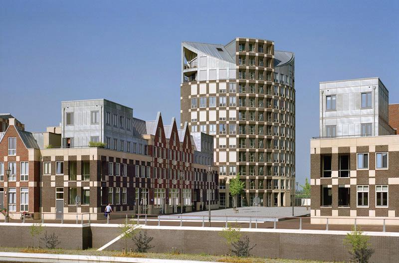
Image source: http://www.natalini-map

Image source: www.landezine.com/index. php/2010/11/quay-and bridges-on-theriver-ijssel-by-okra-landscapearchitecture/,
Fortification case study: Ijsselkade
Residential Area, The Netherlands
This project deploys fortification as a response to SLR in the form of a vertical embankment wall. Doesburg sits on a heavily branched river system with its sea level fluctuating by up to 5 metres, and high dikes have traditionally been used to prevent flooding. A previously industrial area between the town centre and fortified dike, this area was revitalised between 1997 and 2005 into a residential area using the higher ground established by the dike as prime real estate (Prominski, Stokman, Stimberg, Voermanek, & Zeller, 2012, p. 182). Entrances are now 6 metres above sea level, with steps connecting the two levels (Prominski et al., 2012, p. 182). The dike accommodates a floodable wharfage, and a 20 metre wide promenade, however staggering the below house parking was highly energy and cost extensive. The key lesson of this project is that while fortification is an expensive option however there is the potential to build above it.

Image source: http://www.watoday.com.au/ wa-news/seabird-panics-asstorms- approachas-wa-government-sits-on-2-million-inallocated-funds-20160415-go7bdu.html
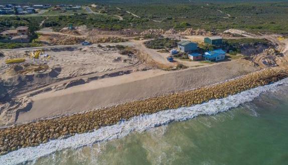
Image source: http://www.watoday.com.au/ wa-news/seabird-seawall-extended-in-panicas-erosion-eats-at-car-park-20160706-gpzr2g. html
Fortification case study: Seabird, Western Australia
This project deploys fortification as a response to SLR in the form of a tapered embankment wall. Seabird is a small coastal town 100 kilometres north of Perth for which coastal erosion has become a dramatic issue. In 2016, after more than a decade of lobbying by community residents, the WA State government gave $2million to the Shire to help protect 15 homes under immediate threat from destruction (Department of Regional Development, 2016). As has been explored in a similar Australian coastal context, SLR is an emotional issue for residents in such communities who are highly attached to key elements of their physical landscape. As O’neill explains:
For place attachments that are threatened by flooding, and adaptation to flood risk, include the personal and communal identities associated with the tourism and fishing industries; the sense of belonging from living and re-living family connections to local
places; the sense of community that comes from living in a semi-rural coastal settlement; and enjoyment derived from diverse recreational activities (O’Neill & Graham, 2016, p. 11).
These funds have been used to build a 500 metre long sea wall (The Shire of Gingin), costing the community the loss of the beach. As there are up to 30,000 residential dwellings facing similar threats in Western Australia (Australian Government) the decision to protect private property ad hoc in Seabird is significant to issues of responsibility and precedence for liability. In addition such works provide a false sense of security for homeowners, for whom the long term inevitability of coastal erosion is masked by a comparatively short term fix. Furthermore, this is an issue that is potentially replicated across Australia: there are approximately 711,000 homes in coastal zones, of which ‘up to 35 per cent are at risk of inundation within ninety years under a plausible sea level rise scenario of 1.1 m’. (Gurran, Norman, & Hamin, 2013)p.100).
This project demonstrates that governance and liability must be addressed proactively to ensure consistency across the State/nation. Furthermore, these measures have more than a financial cost; indeed the loss of beach amenity and ecosystem services – the basis upon which many live at Seabird – are also lost. Such responses have significant implications for future Perth water planning, challenging any proposals that may be implemented in isolation, ad hoc, or without fully addressing the long term realities of those residing on the coast.
This project demonstrates that governance and liability must be addressed proactively to ensure consistency across the State/nation. Furthermore, these measures have more than a financial cost; indeed the loss of beach amenity and ecosystem services – the basis upon which many live at Seabird – are also lost. Such responses have significant implications for future Perth water planning, challenging any proposals that may be implemented in isolation, ad hoc, or without fully addressing the long term realities of those residing on the coast.

Image source: Prominski, M., Stokman, A., Stimberg, D., Voermanek, H., & Zeller, S. (2012). River. Space. Design: Planning Strategies, Methods and Projects for Urban Rivers: Walter de Gruyter.

Image source: http://www.dekkergroep.eu/ projects/ exploitations/tull-en-t-waal/, Accessed 21 July 2017.
Fortification case study: Waal, The Netherlands
This project deploys fortification as a response to SLR in the form of a dike. The Waal is a busy and large waterway fed by the River Rhine. In 1996 the need to increase the height of the dikes required their width to also be increased. To accommodate this augmentation of scale and bulk the intention was to blend it into the surrounding landscape. To do so the upper section was tapered, making it appear narrower than it is. Clay was used as a stabiliser at the base of the dike to allow the width to be kept to a minimum in relation to its height. Allowing for this tapered effect also enables the dike to be utilised as a road or path.
This engineering style demonstrates that there are various techniques for minimising bulk/scale of fortification measures, and that dikes can accommodate transport infrastructure. In the context of Perth water this may be useful in maintaining a level of infrastructure around its edges in the
short term.

Image source: http://www.archdaily. com/332700/east-river-blueway-plan-wxystudio-newyork- citys-plan-for-flood-barrieralong-east-river

Image source: http://mcbrooklyn.blogspot.com. au/2010/08/,
Accommodation case study: East River Waterfront, New York
This project deploys accommodation as a response to SLR in the form of restored wetlands. For more than 100 years the East River waterfront operated as an industrial hub, and increased infrastructure – in particular, a major freeway alongside the river – resulted in dramatically less access to the river for residents. In adapting to the natural and more volatile state of the waterfront, and prioritising access to these areas, this waterfront is now a 57 acre New York City public park.
The East River BlueWay Plan was a comprehensive and integrated plan to redesign from Brooklyn Bridge to East 86th Street in New York. It encompassed many integrated projects; its primary aims including enhancing recreational access as well as flood mitigation measures through ‘soft infrastructure’, such as wetlands – one of the ‘most productive ecosystems on Earth’ whose ‘vegetation tends to stabilize their relative elevation and
seaward extent through feedbacks that vary with the depth and duration of flooding’ (Kirwan & Megonigal, 2013, (Kirwan, 2013)p.53). The reinstated wetlands in New York fostered an ecological revitalisation that provided newly protected habitats for marine life and birds. These interventions also provided access to the river for local residents and visitors, and therefore allow the wetlands to have a positive impact on human health.
This project has served as a benchmark for the ways in which flood mitigation and ecosystem service provision can coexist, creating a space which promotes biodiversity and the interaction of city residents with nature. As such, restored wetlands that maintain recreational access could be a feasible and advantageous transformation to areas of Perth water in particular, providing increased ecosystem services than are currently offered. A key lesson for the Perth context, then, is that adapting to SLR can produce highly desirable outcomes in environment and amenity.

Image source: http://www.landezine.com/index. php/2015/03/a-resilient-landscape-yanweizhouparkin-jinhua-city-by-turenscape/,

Image source: http://www.landezine.com/index. php/2015/03/a-resilient-landscape-yanweizhoupark-in-jinhua-cityby-turenscape/,
Accommodation case study:
Yanweizhou Park, Jinhua City
This project deploys accommodation as a response to SLR in the form of restored wetlands floodable parks. Yanweizhou Park is a 26-hectare wetland park at the mouth of three rivers in China. After years of flood impact mitigation through fortification, harming the ecosystems as well as being merely a temporary solution, the Jinhua City government chose to demolish flood walls (Fleetwood).
The Yanweizhou Park project uses ‘a cut-and-fill strategy to balance earthwork and by creating a waterresilient terraced river embankment that is covered with flood adapted native vegetation’(Landezine, 2015). The terraces are the key feature of this design, performing several important functions. The first is that they provide pedestrian areas that can be used when not flooded. Secondly, the terraces are designed in such a way that flooding is used as a means to irrigate and fertilise the terraces, which
are home to native vegetation (Hobson, 2015). Finally, this feature operates as stormwater management, filtering and water retention .
As with the adaptations of East River, New York, floodable parks are a potentially transformative addition to our river edges, providing a highly designed, multi -functional space that is beneficial in numerous ways, while accommodating both short term storm surges and SLR. Again these landscapes offer the possibility of an improved experience of a natural space, whereby the false separation of land and water is dissolved.

Image source: http://lifeedited.com/hope-andhomes-float-with-houseboats/,

Image source: Prominski, M., Stokman, A., Stimberg, D., Voermanek, H., & Zeller, S. (2012). River. Space. Design: Planning Strategies, Methods and Projects for Urban Rivers: Walter de Gruyter
Accommodation
case study:
Maasbommel, The NetherlandsThis project deployed accommodation as a response to SLR in the form of floating and piled buildings. Along the Maas River is Gouden Ham, a spot known for its recreational uses. Prone to increasingly frequent flooding, and with the added pressure of sea level rise, the area was high risk and becoming unliveable. However the demand for more housing compounded this issue, making retreat from such flood-prone areas not always viable. Indeed, the Dutch government estimates 500,000 new homes will be needed in the next two decades (Kroeger, 2007).
In 2007 a pilot project of 14 floating and 32 amphibian holiday homes was implemented. The amphibious homes are fastened to flexible mooring posts and rest on concrete foundations. (Platform”, 2015)Designed in such a way to rise and float according to river level tide increase of 5.5 metres. (Platform”, 2015)). Although relatively
expensive they are seen as a permanent solution, showing innovative options for the coexistence of residential housing and sea level rise. In the face of the inevitable – and possibly unpopular –need for residential retreat from river edges such housing options could provide an attractive and functional solution to those who wish to continue to live close to Perth water.

Image source: http://theecoreport.com/ hafencityis-designed-to-be-flood-proof/

Image source: http://www.wnyc.org/story/ see-how-new-yorkcan-survive-flooding-lookhamburg/
Accommodation case study: Hafen City, Hamburg, Germany
This project deployed accommodation as a response to SLR in the form of multi-tiered access networks. Hafen City comprises a series of urban islands in Hamburg, which are the result of a redevelopment of the old harbour. It is prone to annual flooding, which in the past has been disastrous. The area underwent a multi-billion dollar restoration to prepare and withstand current flooding and future sea level rise. The area sits 4.5 to 5 metres above sea level, with over 10 kilometres of quayside promenade.
A central element of construction was an innovative multi-tiered approach to public and private spaces (Hafen City). Public spaces were more than 7 metres above normal high tide, and developers were permitted to build at the original ground level on the proviso that the structures were waterproofed and have additional elevated entrances (Grossman, 2015). The second floor is attached to an elevated pathway wide
enough for service vehicles. This multi-tiered ‘escape route’ system is able to accommodate a sea level rise of 9 metres (Voorendt).
A massive redevelopment project the, Hafen City case demonstrates that there are myriad creative ways in which humans can adapt to inevitable SLR (as well as interim flooding). While such projects would not be practical or desirable in all contexts there is the potential for such measures undertaken where current projects are being planned along the Perth river edge, with the opportunity for specific construction and engineering to be put in place from the outset.

Image source: https:// www.ice.org.uk/ ICEDevelopmentWebPortal/media/ DisciplinesResources/Case%20Studies/aerial-viewofmedmerry- managemed-realignment.jpg

Image source: http://www. southampton.ac. uk/~imw/jpg-Bracklesham/15BRKSouthernMedmerry-from-Prom.jpg,
Retreat case study: West Sussex, UK
This project deployed retreat as a response to SLR in the form of ‘nature reserve.’ Medmerry is on the coast of Sussex, England. The previously existing defence, a 3 kilometre shingle bank, was subject to regular breaches from storms and increase sea level (McAlinden, 2015). The decision to cease reinforcing this coastline created a new 7 kilometre long floodway, stretching almost 2 kilometres inland. In addition drainage and a 1.8 kilometre diversion channel mitigating flood risk for nearby counties were created. In total this cost £28 million alleviating the regular costs of reinforcing the breached banks. This retreat meant the establishment of 183 hectares of new intertidal habitats. It is now the largest open coast scheme in Europe.
The Western Australian coast is vast and there are large areas where the issues of residential retreat or commercial property risk are not present. While there may be current
foreshore reserves in place for recreational purposes the opportunity to transform areas of the WA coast into large-scale nature reserves would yield significant benefits. In this instance SLR can be a positive catalyst for the reintroduction of ecological complexity.

Image source: https://iowaenvironmentalfocus. wordpress.com/tag/nebraska/

Image source: http://www.dsmh2o.com/ improvements-since-93-desmoines-floods/,
Retreat case study: Iowa, USA, 1993
This project deployed retreat as a response to floods in the form of ‘buyout.’ The Midwest floods in 1993 were catastrophic, affecting 532 counties across nine states of the U.S. 6.6 million acres were flooded. Damages totalled $15 billion, and a thousand levees failed. Iowa was particularly devastated, with the extent of damage and impact on residents so high that it created a new era of policy around flood mitigation (Freudenberg, Calvin, Tolkoff, & Brawley, 2016).
Central to this policy was a system of highly coordinated buyouts: as Conrad et al. have stated ‘in many instances the most sensible way to manage high-risk floodplains is to let them be floodplains’ (Freudenberg et al., 2016). Just over 1000 properties were purchased in the buyout – a small percentage of the damaged homes –to create a green space buffer for future flooding and protecting homes that were not demolished.
There were two key elements to the success of this program as opposed to other recovery systems: that pre-flood market prices were offered to residents, and that other incentives were added if residents chose to relocate. These two factors also involved the community in the process. Research in Australian context has shown that, for retreat strategies to be successful – and be perceived as fair and effective – the values of the residents most affected is integral to planning decisions; indeed, ‘[c] onsideration … needs to be given to the multifarious lived values that exist
and the ways in which these values can be incorporated into future planning decisions’ (Graham, Barnett, Fincher, Hurlimann, & Mortreux, 2014) p.44). The Iowa process demonstrates that proactive governance and communication produces a more successful response, and that people respond to incentives. This has significance for homes on the south side of Perth water, particularly near the Narrows Bridge and Mill Point Road, built on reclaimed land. Putting in place government incentives that encourage agency in the process could be vital in the eventual relocation of these residents.
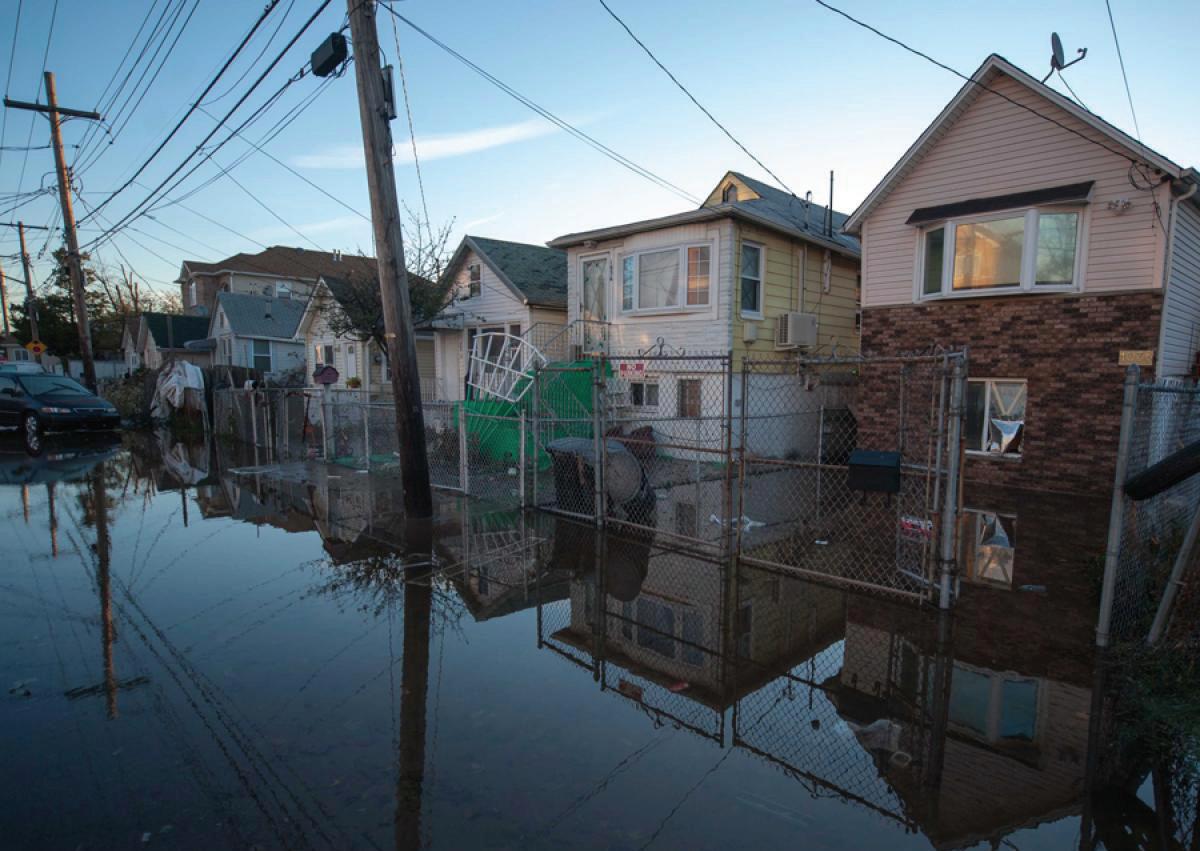
Image source: http://www.nydailynews.com/ news/ hurricane-sandy-strikes-east-coastgallery-1.1194577?pmSlide=1.1991149

Image source: https://ny.curbed. com/2013/4/18/10252320/tracing-the-scarsofhurricane- sandy-on-staten-island
Retreat case study: Staten Island, New York, USA, 2013
This project deployed retreat as a response to SLR in the form of ‘buyout.’
The increase and severity of hurricanes and storms affecting New York has brought the need for a critical response. In 2013, following Hurricane Sandy, Staten Island was identified as one area where repair of damage was not the best option.
A central element of the New York Rising program, established by New York State, was the need for priority buyout areas, that would then be converted to floodplains. Many counties in Staten Island were chosen as high priority. To encourage residents the pre-flood market value was offered on their homes (Freudenberg et al., 2016), resulting in 99 per cent of homeowners of one of the targeted counties, Oakwood Beach, to accept the offer for buyout (Freudenberg et al., 2016).
An additional incentive was offered to those outside the buyout areas, which the communities enthusiastically adopted. These strategies, and the effective communication of them, enabled a smooth transition process; as Alexander, Ryan and Measham state, “many coastal residents will be reluctant to relinquish their land to make way for, or enhance, an ecological barrier (if not part of the original contract), unless they are adequately compensated and feel that the retreat scheme is transparent, fair and just”(Alexander , Ryan, & Measham, 2012, p. 412). This community involvement in these programs was the key to their success, enabling a sense of agency in the
process. Such engagement and coordination made the relocation and buyout of homes palatable. As in the case of Iowa this proactive approach by government is essential in encouraging a positive response from current homeowners in the transition to a managed retreat.
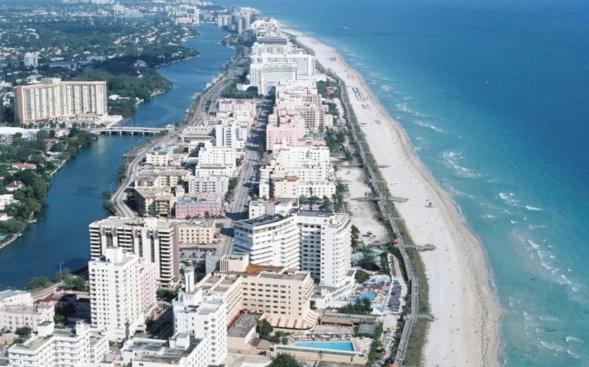

Image source: http://www.tampabay. com/ opinion/editorials/editorial-a-florida-solution-to high-flood-rates/2146759
Business
as usual case study:
Florida, USA, 2017
Approximately 2.4 million Floridians live within one metre of the local high tide line, and by 2100 sea levels could swell high enough to submerge 12.5 percent of Florida’s homes (Strike, 2017).
Construction of residential high rise buildings continues in many of the state’s most at-risk areas, posing great challenges to the Florida insurance market. Its coastal cities, with high tourism and where the beach serves as a major attraction ‘[a] singular focus on the protection of sociocultural values and pursuits, such as beach tourism, dominates other considerations’ (Berry, Fahey, & Meyers, 2013) p.899).
Concurrent to this commercial and tourist focus many low income homeowners or renters in low lying areas have little agency to relocate without government assistance.
In 2002 the Citizens Property Insurance Corporation (Florida Citizens) was created to address the lack of insurance available for high-risk properties. It is now the largest insurance company in Florida, insuring 62 percent of high-rise residential (Strike, 2017). Over the last ten years the liability exposure for Florida Citizens has increased from $155 billion to almost $500 billion (Strike, 2017).
The financial implications of this governmental failure to address SLR in a coordinated way are substantial, and will increase exponentially as the coast continues to erode and storms hit in higher frequency. However the physical consequences for those unable to relocate due to the lack of leadership will prove the most disastrous, as many will
not have the opportunity to avoid the inevitable SLR.
Image source: http://www.atasteoftravelblog. com/48-hours-brisbane-gold-coast-2/,


Image source: http://www.runawaybaymarina. com.au/king-tide-washes-awaythe-coastline/,
Business as usual case study: Gold Coast, Queensland
The Gold Coast, Queensland, is an area particularly at risk from increased sea level rise. A coastal resort city, established in the 1890s with its first high rises in the 1960s and 70s, almost all undeveloped land within 10 kilometres of the coast had been urbanised by the 1980s (Cooper & Lemckert, 2012) p.4) . It is now classed as one of Australia’s premier tourist locations.
Approximately 25,000 residential buildings are currently vulnerable as they are built right up to the beach front (Climate Council, 2014). Currently sand is brought in every year to maintain the beach; average quantities vary between 400,000 and 700,000 cubic metres per year, with additional sand from development excavation within 500 metres also being deposited (Cooper & Lemckert, 2012)p.3)
The current approach has been the extensive construction of additional sea walls, to augment the current ‘A Line’ which is 16 metre deep, 6 metre wide wall (Moore, 2015); a ‘rock-armoured core over which an artificial sand dune is emplaced’ (Cooper & Lemckert, 2012) p.3. This has been at a cost of $5.4 million over the last year alone (City of Gold Coast). The ‘Three-Point Plan’ (2013) promised $30 million to build a mix of new seawalls and dredging sand to replace erosion (Moore, 2015).
The requirement of homeowners to contribute to the funding of these measures has been very contentious. This continued focus on interim solutions is not only expensive, as the same work gets done repeatedly to maintain the status quo, but also raises questions about responsibilities between residents and governments. In the Perth context this is also relevant, with two levels of government (local and state) jurisdiction over the responsibilities for SLR response.
6. Sea level rise strategies and ecosystem service provision
The chapter concludes that fortification strategies deployed on the edges of Perth water are likely to lead to diminished ecosystem service provision...
Chapter 6: Sea Level Rise strategies and their implications for ecosystem service provision
The following chapter sets out a number of fortification, accommodation and retreat strategies for mitigating SLR in relation to particular typical foreshore sections (e.g. Langley Park and South Perth). These study areas have been chosen because the sectional profile is typical and the findings associated with each study area can be generalised to other foreshore areas in Perth Water.
Sea Level Rise assumptions
There is much uncertainty around projections of future climate change and the implications for future sea levels. The uncertainties begin with future emissions scenarios, and extend to the way in which these will affect global temperatures. The outworking of these increased temperatures on global sea level introduces further uncertainty in relation to the influence on both thermal expansion of the oceans and the contribution of meltwater (J. A. G. Cooper & C. Lemckert, 2012, p. 6). In addition base SLR in Perth is also affected by other factors such as tides, storm surges (with a timescale of 1-10 days), the Leeuwin current, and the El Nino effect (Bicknell, 2010, p. 8).
In this uncertain context we have referred to current and well accepted predictions. The scenarios proposed in this chapter are based on SPP 2.6 SLRs at 2100 of +0.5m (medium projection) and +0.9m (high projection) (Western Australian Planning Commission, 2013). All of these are modelled with a 0.7m nominal highest astronomical tide (HAT)
value for the region (Ozcoasts, 2017). Climate change will also lead to increased intensity storm events (J. A. G. Cooper & C. Lemckert, 2012, p. 7), and destructive storm surges (Hurlimann et al., 2014, p. 84) which in the past have typically occurred every 6 to 7 years (Bureau of Meteorology). To capture the possible effects of the interaction between riverine flooding, storm tides and projected SLR we have also included a +2.5m water level which has been established by the Department of Water for the purpose of floodplain management. While we have worked to these projections it is important to acknowledge that sea levels will continue to be rising for hundreds of years (GHD, In press, p. 14). In this respect it is important not to focus on the 2100 projections as an ‘end point’ (Hurlimann et al., 2014, p. 84).
As has been discussed in previous sections, planning responses to SLR exist on a spectrum between the fortification of urban areas from SLR to the retreat of urban areas from advancing SLR (Hurlimann et al., 2014, p. 88). The following section sets out such well-established planning responses to SLR and considers them from the perspective of the planned role of Perth Water’s foreshores as a green infrastructure system yielding both regulatory and cultural ecosystem services (Department of Planning & Western Australian Planning Commission, 2013).
Ecosystem service provision assessment
The assessment of ecosystem service provision is consciously not a full Multi
Criteria Assessment (MCA), rather it is an attempt to understand the broadbrush implications of different responses to SLR for ecosystem service provision, a general process which is appropriate to this necessarily brief study.
Specifically the cultural ecosystem services which are assessed in each foreshore area / and the relevant criteria for measurement are:
of vegetated foreshore area, and the access to the water that such a foreshore area affords.
108
• Physical health: Public open space along rivers which allow access and views to the water have been correlated with increasing physical activity (Giles-Corti et al., 2005, p. 173). This can include a variety of water based forms of recreation such as fishing, canoeing, walking – amongst others. The potential for the SLR scenarios to yield physical health related ecosystem services has been assessed in relation to the likely lateral dimension of vegetated foreshore area, and the access to the water that such a foreshore area affords.
• Mental health: Research has shown that the presence of water , birdlife can have a strong association with mental health (Francis, Wood, Knuiman, & Giles-Corti, 2012, p. 1574). Moreover, research has shown psychological benefits gained by greenspace users increase with levels of species richness (Fuller, Irvine, DevineWright, Warren, & Gaston, 2007, p. 390). The potential for the SLR scenarios to yield mental health related ecosystem services has been assessed in relation to the likely lateral dimension
• Sense of place: The Swan River and its foreshores are a defining characteristic of Perth’s sense of place (Seddon, 1972). The potential for different SLR scenarios to yield sense of place related ecosystem services has been assessed in relation to the degree to which the vegetated foreshores can allow for endemic vegetation and naturalistic edges to the river.
The regulating ecosystem services which are assessed in each scenario/ and the relevant criteria for measurement are:
• Water quality: Reed beds and other wetland growth can act to improve water quality through natural oxygenation (Hoyer, Dickhaut, Kronawitter, & Weber, 2011, p. 23), and act as a biofilter to remove sediments, pollutants and nutrients (Stephenson & Turner, 2013, p. 35). The potential for SLR scenarios to yield water quality ecosystem services has been assessed in relation to the degree to which the vegetated foreshores can allow for wetland/ biofilter edges to the river.
• Mitigating flood risk: Within the academic literature, there is a growing recognition of the benefits of ‘soft protection’ provided by wetland environments to soak up floods and storm surges (Bowering, 2014, p. 344).
The potential for SLR scenarios to yield flood risk mitigation ecosystem services has been assessed in relation to the
degree to which the vegetated foreshores can allow for wetland/ biofilter edges to the river.
• Coastal protection: The UK government’s policy document Making Space for Water proposes the creation of wetlands at sites susceptible to coastal erosion (a process referred to as ‘managed realignment’) (Gandy, 2014, p. 206). The potential for SLR scenarios to yield coastal protection ecosystem services has been assessed in relation to the degree to which the vegetated foreshores can allow for wetland edges to the river.
• Micro-climate regulation: Several studies have demonstrated the cooling effect of large-scale green structures, such as river foreshores (Lenzholzer, 2015, p. 72). The potential for the SLR scenarios to yield microclimate related ecosystem services has been assessed in relation to the likely lateral dimension of vegetated foreshore area, and the potential for it to contain significant tree and understory planting.
Langley Park foreshore, BAU
Without a fortify, accommodate or retreat strategy in place SLR of between 1.2m and 2.5m will see the Langley Park foreshore area almost entirely reclaimed by the river. This will be accompanied by a substantial decrease in ecosystem service provision in relation physical and mental health (due to a lack of space for recreation- passive or active), sense of place (Perth’s characteristic green foreshore reserves will be replaced by an urban edge to the river and many trees will die because of salt water incursion), and the mitigation of flood risk and coastal protection (the foreshore will cease to provide physical protection from floods and storm surges). At the same time, ecosystem services such water quality protection (that require wetland environments not found in the current Langley park section) are not likely to improve in a BAU SLR response.

+0.0m

+1.2m
+2.5m
RiversideDrive

RiversideDrive treedeathsdueto saltwater
TerraceRd TerraceRdLangley Park foreshore, fortification
Fortification strategies in the Langley Park section could take the form of an earth bund running along the present day alignment of Riverside Drive. In a 1.2m SLR situation such a structure should be able to maintain the current area of foreshore devoted to active recreation. As such ecosystem services in relation to physical health should be able to be continued to be provided. However in a 2.5m SLR situation this bund is likely to fail for two reasons. Firstly, river water is likely to be able to seep under the bund. Secondly, if there is an extreme rainfall event storm water collecting behind the bund (on the inshore side) will need to be mechanically pumped into the river. At this point the ecosystem service provision of the Langley Park section will be compromised with respect to physical health and mental health (due to a lack of space for recreation- passive or active), and the mitigation of flood risk and coastal protection (the foreshore will cease to provide physical protection from floods and storm surges). At the same time, ecosystem services such water quality protection (that require wetland environments not found in the current Langley park section) are not likely to improve in a fortification SLR response. +0.0m

 +1.2m
+2.5m
TerraceRd
TerraceRd
Bund
Bund
+1.2m
+2.5m
TerraceRd
TerraceRd
Bund
Bund
Langley Park foreshore, accommodation
Accommodation strategies in the Langley Park section could take the form of new building structures that are designed to allow for periodic inundation of the lower floors, as well as increased wetland planting in the foreshore reserve which should reduce the impact of flood events as well as filtering contaminants. In a 1.2m SLR situation such a reconfigured foreshore should be able to be continue to be provide physical and mental health ecosystem services – however there would be a shift towards more passive recreation (such as walking) from active recreation (such as ball sports) which has larger spatial requirements. At the same time ecosystem service provision in relation to water quality protection, mitigation of flood risk and coastal protection should all increase with the introduction of wetland environments. However in a 2.5m SLR situation the reconfigured foreshore environment will be substantially underwater and as such the provision of all of the ecosystem services will be reduced accordingly.
+0.0m


Langley Park foreshore, retreat
Retreat strategies in the Langley Park section could take the form of a rezoning of currently urban zoned land to a foreshore zoning and the subsequent demolition of buildings which have reached the end of their life-span. Both of these activities would be triggered by certain amounts of SLR (E.g. a 0.5m increase, a 1.0m increase etc.). This strategy essentially would allow the foreshore reserve to migrate inland as SLR occurs. Due to the foreshore width being largely maintained, and the introduction of wetland environments, such a strategy could see ecosystem services such as physical and mental health, sense of place, water quality protection, mitigation of flood risk and coastal protection be maintained, and in the case of water quality protection substantially increase. +0.0m
StGeorgesTce Wetlands
TerraceRd Newroad

RiversideDrive
+1.2m
StGeorgesTce
Wetlands
TerraceRd

RiversideDrive
+2.5m
Mill Point foreshore, BAU
Without a fortify, accommodate or retreat strategy in place SLR between 1.2m and 2.5m will see the Mill Point foreshore, and adjacent urban area, almost entirely reclaimed by the river. This will be accompanied by a substantial decrease in ecosystem service provision in relation physical and mental health (due to a lack of space for recreationpassive or active), sense of place (Perth’s characteristic green foreshore reserves will be replaced by an urban edge to the river and many trees will die because of salt water incursion), and the mitigation of flood risk and coastal protection (the foreshore will cease to provide physical protection from floods and storm surges). At the same time, ecosystem services such water quality protection (that require wetland environments not found in the current Mill Point foreshore section) are not likely to improve in such a BAU SLR response.

+0.0m
SouthPerthEsplanade
 +1.2m
+2.5m
MitchellFreeway
MitchellFreeway
SouthPerthEsplanade
SouthPerthEsplanade
+1.2m
+2.5m
MitchellFreeway
MitchellFreeway
SouthPerthEsplanade
SouthPerthEsplanade
Mill Point foreshore, fortification
Fortification strategies in the Langley Park section could take the form of an earth bund running along the present day alignment of the South Perth Esplanade and the Mitchell Freeway. In a 1.2m SLR situation such a structure should be able to maintain the current area of foreshore devoted to recreation (typically walking and cycling). As such ecosystem services in relation to physical health should be able to be continued to be provided. However in a 2.5m SLR situation this bund is likely to fail for two reasons. Firstly, river water is likely to be able to seep under the bund. Secondly, if there is an extreme rainfall event storm water collecting behind the bund (on the inshore side) will need to be mechanically pumped into the river. At this point the ecosystem service provision of the Mill Point section will be compromised with respect to physical health and mental health (due to a lack of space for recreation- passive or active), and the mitigation of flood risk and coastal protection (the foreshore will cease to provide physical protection from floods and other storm surges). At the same time, ecosystem services such water quality protection (that require wetland environments not found in the current Langley park section) are not likely to improve in such a BAU SLR response.
+0.0m
SouthPerthEsplanade
 +1.2m
+2.5m
Bund
Bund
MitchellFreeway
MitchellFreeway
+1.2m
+2.5m
Bund
Bund
MitchellFreeway
MitchellFreeway
Mill Point foreshore, retreat
Retreat strategies in the Mill Point section could take the form of a rezoning of currently urban zoned land to a foreshore zoning and the demolition of buildings which have reached the end of their life-span. Both of these activities would be triggered by certain amounts of SLR (E.g. a 0.5m increase, a 1.0m increase etc.). This strategy essentially would allow the foreshore reserve to migrate inland as SLR occurs. While this foreshore would be largely submerged in a 2.5m SLR, it could nonetheless yield significant ecosystem services in relation to water quality and coastal protection (through the provision of wetlands), mental health (through the provision of a naturalistic riverine environment).
+0.0m
SouthPerthEsplanade
 +1.2m
+2.5m
Wetland
SouthPerthEsplanade
SouthPerthEsplanade
MitchellFreeway
MitchellFreeway
+1.2m
+2.5m
Wetland
SouthPerthEsplanade
SouthPerthEsplanade
MitchellFreeway
MitchellFreeway
South Perth foreshore, BAU
Without a fortify, accommodate or retreat strategy in place SLR between 1.2m and 2.5m will see the South Perth foreshore area almost entirely reclaimed by the river. This will be accompanied by a substantial decrease in ecosystem service provision in relation physical and mental health (due to a lack of space for recreation), sense of place (Perth’s characteristic green foreshore reserves will be replaced by an urban edge to the river and many trees will die because of salt water incursion), and the mitigation of flood risk and coastal protection (the foreshore will cease to provide physical protection from floods and other storm events). At the same time, ecosystem services such water quality protection (that require wetland environments not found in the current Langley park section) are not likely to improve in such a BAU SLR response.

MillPointRd
MillPointRd

+1.2m
MillPointRd

+2.5m
South Perth foreshore, accommodation
Accommodation strategies in the South Perth section could take the form of new building structures that are designed to allow for periodic inundation of the lower floors, as well as increased wetland planting in the foreshore reserve which should reduce the impact of flood events as well as filtering contaminants. In a 1.2m SLR situation such a reconfigured foreshore should be able to be continue to be provide physical and mental health ecosystem services – however there would be a shift towards more passive recreation (such as walking) from active recreation (such as ball sports) which has larger spatial requirements. At the same time ecosystem service provision in relation to water quality protection, mitigation of flood risk and coastal protection should all increase with the introduction of wetland environments. However in a 2.5m SLR situation the amount of foreshore the reconfigured foreshore environment will be substantially underwater and as such the provision of all of the ecosystem services will be reduced.
+0.0m
MillPointRd

+1.2m
Floodadaptedhousing Floodadaptedhousing

+2.5m
MillPointRd WetlandSouth Perth foreshore, retreat
Retreat strategies in the South Perth foreshore section could take the form of a rezoning of currently urban zoned land to a foreshore zoning and the demolition of buildings which have reached the end of their life-span. Both of these activities would be triggered by certain amounts of SLR (E.g. a 0.5m increase, a 1.0m increase etc.). This strategy essentially would allow the foreshore reserve to migrate inland as SLR occurs. Due to the foreshore width being largely maintained, and the introduction of wetland environments, such a strategy could see ecosystem services such as physical and mental health, sense of place, water quality protection, mitigation of flood risk and coastal protection be maintained, and in the case of water quality protection, substantially increase.
+0.0m
MillPointRd

+1.2m
MillPointRdHopetounSt HopetounSt

+2.5m
Freeway interchange foreshore, BAU
Without a fortify, accommodate or retreat strategy in place SLR between 1.2m and 2.5m will see the freeway interchange area largely reclaimed by the river. This will be accompanied by a substantial decrease in ecosystem service provision in relation physical and mental health (due to a lack of space for passive recreation), sense of place (Perth’s characteristic green foreshore reserves/ freeway park will be submerged and many trees will die because of salt water incursion), and the mitigation of flood risk and coastal protection (the foreshore will cease to provide physical protection from floods and other storm events). At the same time, ecosystem services such water quality protection (that require wetland environments not found in the current freeway interchange section) are not likely to improve in a BAU SLR response. +0.0m
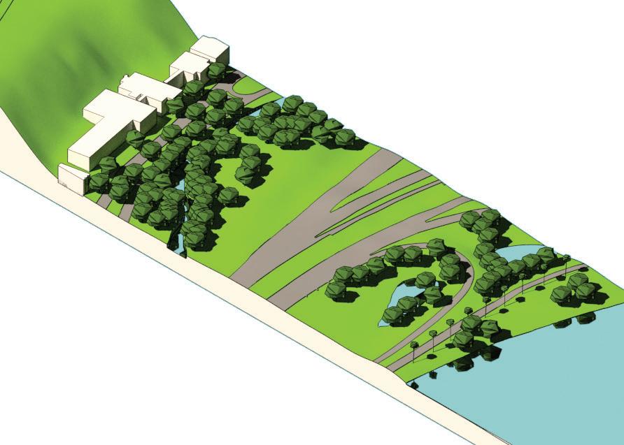
MountsBayRd treedeathsduetosaltwater
RiversideDrive
+1.2m

MountsBayRd

RiversideDrive
+2.5m
MitchellFreeway MitchellFreewayFreeway interchange foreshore, fortification
Fortification strategies in the freeway interchange section could take the form of an earth bund running along the present day alignment of Riverside Drive. In a 1.2m SLR situation such a structure should be able to maintain the current area of the John Oldham and David Carr parks devoted to passive recreation. As such ecosystem services in relation to physical health should be able to be continued to be provided. However in a 2.5m SLR situation this bund is likely to fail for two reasons. Firstly, river water is likely to be able to seep under the bund. Secondly, if there is an extreme rainfall event storm water collecting behind the bund (on the inshore side) will need to be mechanically pumped into the river. At this point the ecosystem service provision of the freeway interchange section will be compromised with respect to physical health and mental health (due to a lack of space for recreation, and the death of trees due to salt water incursion), and the mitigation of flood risk and coastal protection (the foreshore will cease to provide physical protection from floods and other storm surges). At the same time, ecosystem services such water quality protection (that require wetland environments not found in the current freeway interchange section) are not likely to improve in such a BAU SLR response.

 +1.2m
+2.5m
MitchellFreeway
MitchellFreeway
Bund
Bund
MountsBayRd
MountsBayRd
+1.2m
+2.5m
MitchellFreeway
MitchellFreeway
Bund
Bund
MountsBayRd
MountsBayRd
Freeway interchange foreshore, retreat
Retreat strategies in the freeway interchange section could take the form of a rezoning of currently urban zoned land along Mounts Bay Road to a foreshore zoning and the demolition of buildings which have reached the end of their life-span. Both of these activities would be triggered by certain amounts of SLR (E.g. a 0.5m increase, a 1.0m increase etc.). This strategy essentially would allow the existing freeway park and currently urban areas to be, in the longer term, reconstituted as wetlands. As such ecosystem services such as physical and mental health, and sense of place could be maintained, while services such as water quality protection could substantially increase.
MountsBayRd

MountsBayRd
Buildingsrelocated
MountsBayRd

Results and discussion
The following section reflects on the fortification, accommodation and retreat scenarios and their potential to maintain ecosystem service provision in relation to SLR.
Fortification responses to SLR and ecosystem service provision
beach amenity (GHD, 2016, p. iv) which relates to ecosystem services such as physical health. Nonetheless if foreshore sections such as Langley Park are raised to a higher level and protected with fortifications they can continue to provide physical health services which are associated with the existing active recreation uses associated with these areas.
136
As was discussed in chapter 4 the edges of Perth Water are already fortified, in the form of sea wall or rock revetment. The risk of fortifying currently unfortified edges or increasing fortifications where they already exist, to resist SLR in Perth Water and protect urban areas and infrastructure has potentially serious consequences for ecosystem service provision. This is particularly the case where foreshore areas are already narrow such as the Mill Point study area. Fortifications such as seawalls, in defining a clear boundary between dry land and deep water, result in the erosion and eventual washing away of wetlands (for instance) – both in adjacent areas and seaward of the fortifications (Nordenson et al., 2010, p. 14). In turn the loss of these wetlands diminishes ecosystem services in terms of biodiversity (the loss of plants, invertebrates, fishes, and birds that inhabit wetlands), coastal protection (wetlands are the naturally occurring buffer zone between land and water which mitigates the impact of fluctuating sea levels and lowers the risk of flood damage), and water quality protection (wetlands help to purify water) (Nordenson et al., 2010, p. 14). Moreover when fortifications are installed in beach areas, the subsequent erosion of beaches can result in the loss of
Given that the areas around Perth Water have had the highest investment in built form and infrastructure of any area along the Swan and Canning Rivers, it is likely that fortification strategies will be developed to protect these investments. The issue this response presents is how this fortification can occur in a way that ensures the ‘Central Perth Regional Parklands’ – a ‘green infrastructure network ‘essential element to the identity, liveability and ecology of the city’ (Department of Planning & Western Australian Planning Commission, 2013, p. xi) – is able to be maintained. In the longer term, or in a catastrophic climate change situation (Church & Clark, 2016), any fortifications developed will inevitably fail and the retreat of urban areas and their re-zoning as foreshore reserves will be required to maintain the Central Perth Regional parklands. As such, regardless of short term fortification initiatives, planning for urban areas around Perth Water should begin to factor in this inevitable retreat in the longer term. This is currently not the case, significant urban development occurring on the Mill Point peninsula and at the foot of city along Terrace Rd – sites which are highly vulnerable to SLR.
Accommodation and ecosystem
service provision
Accommodation strategies accept a degree of flooding associated with SLR and aspire to minimising the damage associated with this flooding. Accommodation strategies can take the form of new design criteria, such as provisions for pumping of water (J. A. G. Cooper & C. Lemckert, 2012, p. 11), raised floor levels, transportable structures, building designs that allow for periodic inundation of the lower floors, while living spaces are situated on upper levels (Kellett et al., 2014, p. 207). Accommodation strategies applied to urban form have potential at the foot of the city (such as the Langley Park study area) over the short term. However as SLR begins to regularly flood these areas we will see a loss of foreshore area and a decline in ecosystem service provision, associated with that. Nonetheless, in the shorter term, accommodation strategies such as de-fortifying and revegetating the edges of Perth Water could considerably increase ecosystem service provision, particularly those associated with water quality protection, mitigating flood risk and coastal erosion.
Retreat and ecosystem service provision
The migration of urban areas, associated infrastructure, and the foreshore reserve itself inland with SLR has potentially positive implications for the provision of ecosystem services. This is because as the foreshore reserve migrates inland there is an opportunity to design it as a piece of multifunctional green infrastructure which balances environmental, technical, and economic
priorities (Nordenson et al., 2010, p. 14).
Of course the retreat of urban areas, and their rezoning as foreshore reserves, will be deeply unpopular with adjacent landowners. In this respect foreshore retreat can be (partly) incentivised by the provision of a well-designed, multifunctional foreshore. In this way the development of retreat strategies represent much more than ‘deleting’ unviable areas, as Wolff-Plottegg described it (In Gandy, 2014, p. 209) but rather enhancing central Perth’s liveability and ecological performance. In this line of thinking, the retreat of urban areas in Perth Water prioritises right of future generations to an amenable foreshore in the face of a clamour of existing landowners for SLR fortification (Abel et al., 2011, p. 280).
Chapter conclusion
In conclusion, in the short term adaption strategies which seek to de-mineralise Perth Water’s currently fortified edges (where space allows) could see a substantial increase in ecosystem service provision, particular water quality protection, flood risk mitigation and coastal protection. As such while the SLR strategies set out previously are arranged in a linear fashion, there should be consideration of hybrid strategies which, for instance, may begin with fortification, move to accommodation, and finally retreat. In this respect the strategies illustrated in this chapter should be considered pieces of a jigsaw, rather than a direct prescription.
However, over the longer term if the intended green infrastructure, and ecosystem service, functions of the
Central Perth Regional Parklands (Department of Planning & Western Australian Planning Commission, 2013, p. xi) are to be maintained it is inevitable that some retreat of urban areas will be required, along with the migration of the foreshore reserve inland.
138
StudyArea
Current foreshore reserve for +0.0m water level
This figure shows the approximate current locationof the foreshore reserve
Burswood Swan River +1.2m Kings park Perth CBD South Perth Foreshore ReserveMigration of foreshore reserve for +1.2m water level
This figure shows the inland migration of the foreshore reserve to accommodate an up to +1.2m water level situation. Areas of high investment and significance such as Elizabeth Quay and Mill Point could be fortified to respond to this water level.
StudyArea
Migration of foreshore reserve for +1.6m water level
This figure shows the inland migration of the foreshore reserve to accommodate an up to +1.6m water level situation. The migration of the foreshore reserve would require the rezoning of urban areas to a foreshore reserve zoning, particularly in Mill Point in South Perth and between Terrace Road and St Georges Terrace at the foot of the city. Areas of high investment and significance such as Elizabeth Quay could be possibly fortified to respond to this water level.
Burswood Swan River +2.5m Kings park Perth CBD South Perth ForeshoreStudyArea
Figure: Migration of foreshore reserve for +2.5m water level
This figure shows the inland migration of the foreshore reserve to accommodate an up to +2.5m water level situation. The migration of the foreshore reserve would require the rezoning of urban areas to a foreshore reserve zoning, particularly south of St Georges Terrace and the entire Mill Point area. Areas of high investment and significance such as Elizabeth Quay would likely need to be abandoned or significantly adapted, to respond to this water level
Burswood Swan River +7.0 Kings park Perth CBDStudyArea
Figure: Migration of foreshore reserve for +7.0m water level
This figure shows the effects of +7.0m water level situation. the Intergovernmental Panel on Climate Change (IPCC) has projected a rise of as much as 7 m by 2500, but also warned that the available ice-sheet models may underestimate Antarctica’s future contribution.
Burswood7. Conclusion
Managed retreat, and resumption of urban land for foreshore reserve, while complicated is likely to lead to the optimal provision of ecosystem services...
This project initially examined existing, proposed and strategic planning in relation to Perth Water and surrounds by various stakeholders, including City of Perth, City of South Perth, Department of Parks and Wildlife amongst others. In combination with a geospatial and site based analysis this research provides a snapshot of the current condition planning for, Perth Water. It revealed that there is substantial consensus that the foreshores of Perth Water should be considered part of a green infrastructure network, and that they are an essential element of the identity, liveability and ecology of the city.
Given this situation, the report discussed the questions - how can the green infrastructure role for Perth Water’s foreshores, as proposed in existing planning, be enhanced at the same time as adapting to projected Sea level Rise (SLR)? This discussion was carried out in relation to a series of exemplar case study projects, which illustrate three main responses to SLR, fortification, accommodation or retreat. These strategies were spatially tested on the foreshores of Perth Water to understand their implications for the foreshore’s broader green infrastructure functions. These implications were that in the short term adaption strategies which sought to de-mineralise Perth Water’s currently fortified edges (where space allows) could see a substantial increase in ecosystem service provision, particular water quality protection, flood risk mitigation and coastal protection. However, over the longer term if the intended green infrastructure, and ecosystem service, functions of the Central Perth Regional Parklands are to
be maintained it is inevitable that some retreat of urban areas will be required, along with the migration of the foreshore reserve inland.
While in the 20th century we were able to reshape the Swan River to reflect its own desires for handsome foreshore parks, in the 21st century (and beyond) the river will reassert its ability to shape the city (Bolleter, 2015). This report has sought to start a conversation about how this re-assertion can occur in a way that maximises the ecosystem services that define Perth’s liveability and identity. This highlights the importance of the Perth Water Precinct Working Group to carry this conversation forward in a coordinated way.
8. Bibliography
Bibliography
Abel, N., Gorddard, R., Harman, B., Leitch, A., Langridge, J., Ryan, A., & Heyenga, S. (2011). Sea level rise, coastal development and planned retreat: analytical framework, governance principles and an Australian case study. Environmental Science & Policy, 14(3), 279-288.
Alexander , K., Ryan, A., & Measham, T. G. (2012). Managed retreat of coastal communities:
understanding responses to projected sea level rise. Journal of Environmental Planning and Management, 55(4), 26.
148
Australian Government, D. o. E. E. Climate Change impacts in Western Australia. Retrieved 31.10, 2017, from http://www.environment.gov.au/climatechange/climate-science/impacts/wa
Berry, A., Fahey, S., & Meyers, N. (2013). Changing of the Guard: Adaptation Options That Maintain Ecologically Resilient SandyBeach Ecosystems. Journal of Coastal Research, 29(4), 11.
Bicknell, C. (2010). Sea Level Change in Western Australia: Application to Coastal Planning. Perth: Department of Transport: Coastal Infrastructure, Coastal Engineering Group.
Bolleter, J. (2015). Take me to the river: The story of Perth’s foreshore. Perth: University of Western Australia Publishing.
Bowering, E. (2014). Adapting to climate-induced sea level rise on the Gold Coast: lessons from the Netherlands. Australian Planner, 51(4), 340-348.
Bureau of Meteorlogy. Tropical Cyclones Affecting Perth. Retrieved 09.11, 2017, from http://www.bom.gov.au/cyclone/history/wa/perth.shtml
Church, J., & Clark, P. (2016). What does the science really say about sea-level rise? Retrieved 12.07, 2017, from https://theconversation.com/what-does-thescience-really-say-about-sea-level-rise-56807
City of Gold Coast. Seawall construction project. Retrieved 31.10, 2017, from http://www.goldcoast.qld.gov.au/seawall-construction-projects-20762.html
City of Perth. (2010). An Urban Design Framework: A Vision for Perth 2029. Perth City of Perth.
Climate Council. (2014). Counting the Costs: Climaste change and coastal flooding. Retrieved 31.10, 2017, from http://www.climatecouncil.org.au/uploads/5 6812f1261b168e02032126342619dad.pdf
Cooper, & Lemckert. (2012). Extreme sea-level rise and adaptation options for coastal resort cities:
A qualitative assessment from the Gold Coast, Australia. Ocean and Coastal Management, 64, 14.
Cooper, J. A. G., & Lemckert, C. (2012). Extreme sea-level rise and adaptation options for coastal resort cities: A qualitative assessment from the Gold Coast, Australia. Ocean & coastal management, 64, 1-14.
Department of Parks and Wildlife. (2015). Swan Canning River Protection Strategy. Perth: Department of Parks and Wildlife.
Department of Planning, & Western Australian Planning Commission. (2013). Capital City Planning Framework. Perth: Department of Planning.
Department of Regional Development. (2016). Royalties for Regions: Progress report July 2015- June 2016. Perth: Government of Western Australia.
Fleetwood, Y. Park Elevated Walkway. Retrieved 31.10, 2017, from http://www. fleetwoodurban.com.au/inspiration/global/yanweizhou-park-elevated-walkway
Francis, J., Wood, L. J., Knuiman, M., & Giles-Corti, B. (2012). Quality or quantity? Exploring the relationship between Public Open Space attributes and mental health in Perth, Western Australia. Social science & medicine, 74(10), 1570-1577.
Freudenberg, R., Calvin, E., Tolkoff, L., & Brawley, D. (2016). Buy-In for Buyouts: The Case for Managed Retreat from Flood Zones. Lincoln institute of Land Policy, 28.
Fuller, R. A., Irvine, K. N., Devine-Wright, P., Warren, P. H., & Gaston, K. J. (2007). Psychological benefits of greenspace increase with biodiversity. Biology Letters, 3, 390-394.
Gandy, M. (2014). The fabric of space: Water, modernity, and the urban imagination: MIT Press.
GHD. (2016). Cockburn Sound Coastal Vulnerability and Flexible Adaptation Pathways Project. Perth: GHD.
Giles-Corti, B., Broomhall, M. H., Knuiman, M., Collins, C., Douglas, K., Ng, K., . . .
Donovan, R. J. (2005). Increasing walking: how important is distance to, attractiveness, and size of public open space? American Journal of Preventive Medicine, 28(2), 169-176.
Gordon, R. (2003). Sea level change and paleochannels in the Perth area. Australian Geomechanics, 38(4), 84-89.
Government of Western Australia. (2004). Riverplan: An environmental management framework for the Swan and Canning Rivers. Perth: Government of Western Australia.
Government of Western Australia. (2015). Draft Perth and Peel Green Growth Plan for 3.5 million: Summary. Perth: Government of Western Australia.
Graham, S., Barnett, J., Fincher, R., Hurlimann, A., & Mortreux, C. (2014). Local values for fairer adaptation to sea-level rise: A typology of residents and their lived values in Lakes Entrance, Australia. Global Environmental Change, 29, 12.
Grossman, D. (2015). A Tale of two European cities. Retrieved 31.10, 2017
150
Gurran, N., Norman, B., & Hamin, E. (2013). Climate change adaptation in coastal Australia: An audit of planning practice. Ocean & Coastal Management, 86, 9. Hafen City. Flood-secure bases instead of dikes: safe from high water in HafenCity. Retrieved 31.10, 2017, from http://www.hafencity.com/en/concepts/flood-securebases-instead-of-dikes-safe-from-high-water-in-hafencity.html
Hobson, B. (2015). Terraces of plants in Yanweizhou Park control flood in ecological way. Retrieved 31.10, 2017, from https://www.dezeen. com/2015/12/07/terraces-of-plants-yanweizhou-park-control-floods-ecologicalturenscape-landscape-architecture-china/
Hoyer, J., Dickhaut, W., Kronawitter, L., & Weber, B. (2011). Water sensitive urban design: principles and inspiration for sustainable stormwater management in the city of the future: Jovis Hamburg, Germany.
Hurlimann, A., Barnett, J., Fincher, R., Osbaldiston, N., Mortreux, C., & Graham, S. (2014). Urban planning and sustainable adaptation to sea-level rise. Landscape and Urban Planning, 126, 84-93.
Kellett, J., Balston, J., & Western, M. (2014). Sea-level rise and planning: retrospect and prospect. Australian Planner, 51(3), 203-211.
Kirwan, M. L. M., J. Patrick (2013). Tidal wetland stability in the face of human impacts and sea-level rise. Nature, 504, 9.
Kroeger, A. (2007). Dutch pioneer floatijng eco-homes. Retrieved 31.10, 2017, from http://news.bbc.co.uk/1/hi/world/europe/6405359.stm,
Landezine. (2015). A Resilent Landscape, Yanweizhou Park in Jinhua City.
Retrieved 31.10, 2017, from http://www.landezine.com/index. php/2015/03/a-resilient-landscape-yanweizhou-park-in-jinhua-city-by-turenscape/
Lenzholzer, S. (2015). Weather in the City: How Design Shapes the Urban Climate. Rotterdam: nai010.
Mandle, L., & Tallis, H. (2016). Spatial Ecosystem Service Analysis for Environmental Impact Assessment of Projects. Handbook on Biodiversity and Ecosystem Services in Impact Assessment, 15.
McAlinden, B. (2015). Managed realignment at Medmerry. Retrieved 31.10, 2017, from https://www.ice.org.uk/ICEDevelopmentWebPortal/media/DisciplinesResources/Case%20Studies/aerial-view-of-medmerry-managemed-realignment. jpg
McDonald, R. (2015). Conservation for Cities: How to Plan and Build Natural Infrastructure. Washington: Island Press.
Moore, T. (2015). Gold Coast beach erosion plan: Is the plan on the right track? Retrieved 31.10, 2017, from http://www.brisbanetimes.com.au/queensland/ gold-coast-beach-erosion-plan-is-the-plan-on-the-right-track-20150705-gi5cz2. html
Murphy, P. (2012). The metropolis. In P. Maginn & S. Thompson (Eds.), Planning Australia: An overview of urban and regional planning (pp. 155-179). Melbourne: Cambridge University Press.
Nordenson, G., Seavitt, C., & Yarinsky, A. (2010). On the Water: Palisade Bay. New York: Museum of Modern Art.
O’Neill, S. J., & Graham, S. (2016). (En)visioning place-based adaptation to sea-level rise. Geo: Geography and Environment, 3(2), 16.
Ozcoasts. (2017). Australian Online Coastal Information. Retrieved 29.06, 2017, from http://www.ozcoasts.gov.au/climate/Map_images/Perth/mapLevel2_North.jsp
Platform”, E. C. A. (2015). Floating and Amphibious Housing Retrieved 10 November 2017, from http://climate-adapt.eea.europa.eu/metadata/adaptationoptions/floating-and-amphibious-housing
Prominski, M., Stokman, A., Stimberg, D., Voermanek, H., & Zeller, S. (2012). River. Space. Design: Planning Strategies, Methods and Projects for Urban Rivers: Walter de Gruyter.
Schwalbach, G. (2009). Urban Analysis. Basel, Boston, Berlin: Birhauser.
Seddon, G. (1972). Sense of Place. Perth: The University of Western Australia Press.
Seddon, G., & Ravine, D. (1986). A City and Its Setting: Images of Perth, Western
Australia. Perth: Fremantle Arts Centre Press.
Stephenson & Turner. (2013). From Resistance to Resilience: A New Paradigm of Coastal Cities. New Zealand: Stephenson & Turner.
Strike, S. (2017). Overwhelming Risk.
Swan River Trust. (2006). Healthy Rivers Action Plan. Perth: Swan River Trust.
The Shire of Gingin. The Seabird Seawall Story. Retrieved 31.10, 2017, from http://www.gingin.wa.gov.au/home/seabird-seawall-video.aspx
Voorendt, M. Hamburg: Multi functional flood defence. Retrieved 31.10, 2017, from http://www.flooddefences.org/hamburg.html
Western Australian Planning Commission. (2005). State Planning Policy No. 2.10
Swan-Canning River System. Perth: Government of Western Australia.
Western Australian Planning Commission. (2013). State Planning Policy No. 2.6 State Coastal Planning Policy. Perth: Government of Western Australia.
152
Ozcoasts. (2017). Australian Online Coastal Information. Retrieved 29.06, 2017, from http://www.ozcoasts.gov.au/climate/Map_images/Perth/mapLevel2_North. jsp
Schwalbach, G. (2009). Urban Analysis. Basel, Boston, Berlin: Birhauser.
Seddon, G. (1972). Sense of Place. Perth: The University of Western Australia Press.
Stephenson & Turner. (2013). From Resistance to Resilience: A New Paradigm of Coastal Cities. New Zealand: Stephenson & Turner.
Straton, A. T., Jackson, S., Marinoni, O., Proctor, W., & Woodward, E. (2011). Exploring and evaluating scenarios for a river catchment in Northern Australia using scenario development, multi-criteria analysis and a deliberative process as a tool for water planning. Water Resources Management, 25(1), 141-164.
Swan River Trust. (2006). Healthy Rivers Action Plan. Perth: Swan River Trust.
Western Australian Local Government Association. Local Biodiversity Program: Mapping and Information. Retrieved 21.09, 2016, from http://pbp.walga.asn.au/ Tools/MappingandInformation.aspx
Western Australian Planning Commission. (2005). State Planning Policy No. 2.10
Swan-Canning River System. Perth: Government of Western Australia.
Western Australian Planning Commission. (2013). State Planning Policy No. 2.6
State Coastal Planning Policy. Perth: Government of Western Australia.
9. Contributors
The research work of AUDRC is supported by the Metropolitan Redevelopment Authority.

Julian Bolleter
Julian is an Assistant Professor at the Australian Urban Design Research Centre (AUDRC) at the University of Western Australia. His role at the AUDRC includes teaching a master’s program in urban design and conducting urban design related research and design projects.

Joerg Baumeister
Joerg is Director of the Australian Urban Design Research Centre (AUDRC) and has been researching, practising, educating and exploring Urban Design and Architecture for more than 20 year in Australia, Europe, Africa, and on the Arabian Peninsula.

Zoe Myers
Dr Zoe Myers is a researcher and lecturer at the Australian Urban Design Research Centre (AUDRC) at the University of Western Australia, where she contributes to state and local research and design projects, and teaches in the Master in Urban Design. Zoe holds a PhD in Australian History, and has experience spanning policy, project management, strategic communications, and web design. Her current interests are the design of ecologically regenerative and creative urban spaces, and ensuring urban design research has genuine social impact.

Iwan is an urban design intern at the Australian Urban Design Research Centre (AUDRC) currently assisting in design and research projects at the centre. He is a recent urban design graduate from AUDRC and has a background in architecture and town planning.

Bill Grace
Bill is a Fellow of Engineers Australia with over 30 years of experience in infrastructure and development in Australia and internationally. He is an independent sustainability adviser, researcher and consultant, and an Adjunct Professor at the University of Western Australia’s Urban Design Research Centre. Bill works at the interface of economics and sustainability, advising state and local government agencies and land developers. He has extensive multidisciplinary multi-faceted experience in providing strategic advice on sustainability aspects of land development, including integrated urban water cycle management, sustainable energy, materials and waste management and green building design.