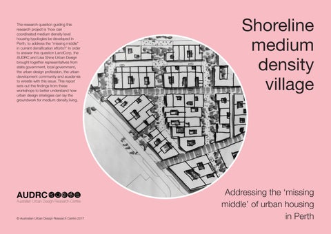
The research question guiding this research project is ‘how can coordinated medium density level housing typologies be developed in Perth, to address the “missing middle” in current densification efforts?’ In order to answer this question LandCorp, the AUDRC and Lisa Shine Urban Design brought together representatives from state government, local government, the urban design profession, the urban development community and academia to wrestle with this issue. This report sets out the findings from these workshops to better understand how urban design strategies can lay the groundwork for medium density living.
Shoreline medium density village
© Australian Urban Design Research Centre 2017
Addressing the ‘missing middle’ of urban housing in Perth
Contents 6 1.Introduction 8 2.Key urban design principles for delivering the ‘missing middle’ 18 3.Stakeholder engagement and urban design process 46 4.Shoreline model urban villagean exemplar for coordinated medium density development 68 5.Contributors
5
1.Introduction
This research project addresses the question of how Perth can address it’s ‘missing middle’ in terms of urban density...
6
In late 2016 the Australian Urban Design Research Centre (AUDRC) was engaged by LandCorp to facilitate urban design workshops and develop an urban design proposal for the Shoreline Model Urban Village, which comprises Lot 207 of the Robb Jetty Local Structure Plan area, and part of the broader Shoreline development area. The research question guiding this process was ‘how can medium density housing typologies be developed in Perth, to address the “missing middle” in current densification efforts?’
The ‘missing middle’ is understood in this project to mean residential development which has a maximum height of 5 stories and a net density of 25-260 dwellings per hectare – this typically includes 2-3 storey compact housing, terrace style housing, maisonette (manor) housing, dual occupancy housing, townhouse housing, and low rise apartments.
In order to address the overarching question LandCorp, the AUDRC and Lisa Shine Urban Design brought together representatives from state government, local government, the urban design profession, the urban development community and academia to wrestle with this issue. This engagement process included three consecutive urban design workshops conducted over a brief 3 month period. The following report sets out the key urban design principles by which coordinated medium density housing can be delivered, the stakeholder engagement and design process conducted, and the current Shoreline Model Urban Village planning which
serves as an exemplar for how the ‘missing middle’ can be addressed in Perth.
This report should be read in conjunction with the following documents:
• The Cockburn Coast Public Realm Design Guidelines
• The Robb Jetty Design Guidelines
• The Robb Jetty Local Structure Plan
The housing typology section of the engagement workshops was facilitated by Lisa Shine Urban Design and is not covered, in full, in this report.
7
2.Key urban design principles for delivering the ‘missing middle’
The following chapter sets out the key urban design principles which can aid in the delivery of the ‘missing middle’ in Perth...
8
To successfully incentivise medium density living, it is generally regarded such development must offer the trifecta of public transport access, high quality public open space (POS) and access to retail land uses. At a finer, urban design scale however there are a number of techniques which can be deployed. These ‘principles’ for achieving coordinated medium density housing in Perth are set out on the following pages in relation to lot and housing types, public open space, and laneways (and small streets). The housing typology section of the engagement workshops was facilitated by Lisa Shine Urban Design and is not covered, in full, in this chapter.
9
Principles for achieving coordinated medium density development –
Lot and housing types:
• Allow for a diversity of housing types through the provision of appropriate lot sizes that are appealing to a wide spectrum of developers – from mom and dad investors to tier 2/3 developers. These include compact housing (lots ranging from 45-150m2), maisonette (manor) housing (lots ranging from 250m2), dual occupancy housing (lots ranging from 250m2), terrace housing (lots ranging from 150-220m2), low rise apartment housing (lots from 450m2). Lot types (and planning controls) should preclude free standing suburban housing types.
• Low rise apartments should be concentrated on corner lots in preference to terrace typologies so as to avoid ‘dead edges’ which can result from terraces ‘siding’ onto one street/ laneway.
• In achieving an ‘urban’ feel 2 storey terraces with a maisonette on the third level are preferable to 3 storey terrace housing types which are typically difficult to develop because buyers are reluctant to pay the additional $100,000-$150,000 for the third level.
• Higher density housing should be concentrated along the edges of sites with major roads so as to provide a defined ‘urban edge.’
10
• Lot arrangement should be flexible so as to enable development models to vary with changing economic conditions. For instance a run of terrace products can be amalgamated into a larger super lot, for larger developers, or remain as single lots for smaller developers.
• Amalgamated lot arrangement should allow for re-subdivision post development.
• Long, thin terrace lots which pose problems for achieving solar access should be avoided.
• ‘Easy and ‘challenging’ lot types in terms of development feasibility should be packaged together for developers so that developers are incentivised to tackle challenging lots.
• Micro lots (~70m2) should be provided in smaller groups close to POS.
11
Principles for achieving coordinated medium density development –Public Open Space:
• Local POS should build upon the sense of place and amenity of the local landscape
• The design and layout of local scale POS needs to be configured to compensate for diminished private open space provision in medium density urban form, and to incentivise downsizing. In this respect it should be more garden like, and intimate, than park like and open.
• Local POS should be designed so local residents have ownership of it and contribute to its maintenance. This can be achieved, in one respect, by locating public planting boxes in line with, and adjacent to housing frontages.
12
• Local POS needs to be consolidated into sizeable parcels for ease of maintenance by local government maintenance teams.
• Medium density housing types should overlook POS, particularly from balconies on the 2nd and 3rd stories.
• Zero frontage and side setbacks which address public space/ laneways should have an appropriate threshold treatment, involving planting, screening, or possibly a level change, which ensures privacy and a degree of appropriate degree of surveillance
• Higher density ‘missing middle’ housing typologies should be correlated with access to significant, ideally district or neighborhood scaled POS, and views.
13
Principles for achieving coordinated medium density development –Laneways (and small streets):
In general terms laneways which are unattractive, poorly surveilled, and have no trees or planting work against incentivizing medium density development, particularly when ‘garage apartments’ overlook laneways .
• Laneways should be designed with the required width to allow for tree and shrub planting
• Garage doors on rear accessed medium density housing should be visually permeable to allow passive surveillance of laneway.
• Building edges abutting laneways should have varied setbacks, and be articulated, to allow for visual interest.
• Laneways should be paved with a material which denotes the laneway as a shared pedestrian/ vehicular space
14
15
Principles for achieving coordinated medium density development – Car parking
• Where possible utilise ‘tandem’ car parking in garages adjoining laneway rather than double garages which have side by side parking and can lead to a ‘garage heavy’ laneway.
• On larger development sites and amalgamated super lots (above 600m2) parking should be accommodated below, or partly below, ground levels without adversely affecting active streetscapes.
• Access to combined parking areas should not be provided from active street frontages.
16
17
3.Stakeholder engagement and urban design process
The following section sets out the stakeholder engagement and design process undertaken to arrive at the Shoreline Urban Model Village...
18
19
Process
The diagram below sets out the stakeholder engagement process undertaken to arrive at the Shoreline model urban village. Each step of this process is explained in more detail in the following pages.
Workshop 1:
• General briefing
• Presentation of site analysis
• Presentation of open space typologies which could structure Lot 207 (fields, paths, courtyards, promenades)
• Presentation of ‘missing middle’ housing types
• Sketching of possible development scenarios in small groups incoporating open space and housing types
1a. Design development:
• Development of urban design scenarios from workshop 1 sketches
• Development of lot types, dwelling types and circulation diagrams
5. Possible next steps:
• Partnering of Landcorp with a developer to develop a demonstration precinct
• Collaborative design process involving developers to design ‘cells’ within the scheme, particularly in relation to car parking
• Assumptions about buyers preferences to be tested with market research
• Documentation of the Lot 207 scheme for regulatory approvals
Workshop 4, presentation to DoP and CoC:
• Presentation of Lot 207 scheme to DoP and CoC
20
Workshop 2:
• Discussion of possible site ‘identities’ carried out in small groups
• Small group exercise to assess urban design scenarios against criteria (spatial efficiency, potential yield, suitability to coastal context, flexbility, diversity, amenity) and dismiss less suitable options
2a. Design development:
• Internal workshop to confirm selected development option and further develop urban design principles
3a. Design development:
• Revision of selected option in relation to workshop 3 feedback
Workshop 3:
• Large group critique and refinement of selected option in relation to lot sizes and configuration, public open space quality and management, lot types, housing types mix.
• Discussion of laneway/ street types
21
Workshop 1: Site analysis
This plan summarizes the site analysis presented in workshop 1. The site’s northern aspect facing onto the POS spine, with views to the ocean is identified as a significant opportunity.
22
Ocean views (2nd floor)
Winter sun/ wind protection
23
POS integration
Oceanviews(2ndfloor)
Workshop 1: Open space types
These varied open space typologies were used to structure the intial scenarios developed in small groups
Courtyards
Fields
24
Paths
Promenades
25
Workshop 1: Scenario sketches
Sketching of possible development scenarios in small groups incoporating open space and housing types
26
27
Workshop 1: Common themes
raised by participants
• The development should be both urban and coastal in feel
• The open space structure should be legible yet varied
• Urban patterns should be permeable and provide pedestrian links to surrounding areas, the district centre, linear POS and pedestrian bridge
• A range of lot sizes should be distributed throughout the development suitable for a variety of housing typologies
• Larger apartment lots should be located generally on the northern edge of the development on landmark sites with potential views, and in the south adjacent to the district centre
• Lots should be suitable for housing that has an urban feel - not suburban
• A range of different terrace products should be provided in short runs
• Exterior streets should have defined urban edges
• Too many openings should be avoided along potential Bus Rapit Transit (BRT) route
28
29
1a. Design development
Subsequent to workshop 1 ‘interpretive’ plans were developed from the scenario sketches produced in workshop 1
30
31
Workshop 2: Scenario assessment
In workshop 2 a small group exercise to assess urban design scenarios against criteria (spatial efficiency, potential yield, suitability to coastal context, flexbility, diversity, amenity) was carried out
32
33
Workshop 2: Identity discussion
Discussion of possible site ‘identities’ in relation to the coastal context was carried out in small groups
34
35
Workshop 2: Common themes
raised by participants
Roads
• Issues around vehicular movement and refuse collection need to be resolved
• Direct/ straight vehicular connections should be adopted in preference to looping configurations
• Concerns raised about garage ‘heavy’ laneways
Open Space
• Open space should be rationalised into one common area
• Open space should be differentiated from the district open space provided adjacent to Lot 207
• The model for the maintenance of open space needs to be resolved
Lots
• The lots need to be of a size and proportion that are appealing to the spectrum of developers likely to be involved
• Concerns raised about the inadequate depth (in a number of the schemes) fronting onto the major POS to the north
• The sites to the NW, W and S provide the best opportunities for density
Permeability
• Pedestrian permeability running north-south through Lot 207 should be provided
36
37
2a. Design development: Urban design principles
Subsequent to workshop 2 basic urban design principles were adopted to structure the development. East-west running lanes/ small streets were regarded as important for providing vehicle permeability, north facing building orientation, and general legibility.
38
~30m ~40m
1020 50m 0 39
2a. Design development: Urban design principles
A north-south running open space spine was regarded as important for amenity, pedestrian permeability and development identity.
40
15-10m
1020 50m 0 41
Workshop 3: Refinement of selected option
Workshop 3 involved critique and refinement of the selected option in relation to lot sizes and configuration, public open space quality and management, lot types, housing types mix.
42
43
Workshop 3: Street/ laneway precedent projects
In workshop 3 various precedents for laneways and small streets were presented and a discussion was had as to their possible application in the development.
Osprey Quay Regeneration Area, Portland, USA (proposed)
+ varied width roadway
+ meandering roadway
+varied building setbacks
+ signficant planting
- presents challenges to refuse collection
44
Ba01 Malmo, Sweden
+ varied width roadway
+ no distinction between vehicular and pedestrian spaces
Ba01 Malmo, Sweden- 4m roadway
+ slight step up to dwelling entrances
+ incorporation of water sensitive urban design principles
Section
45
4.Shoreline model urban village- an exemplar for coordinated medium density development
The following section explains the design for the Shoreline model urban village
46
47
APARTMENT
SITE AREA= 1398M2 MIN LEVELS=4 MIN DWELLINGS= 52
Shoreline model urban village plan
This lot layout plan sets out a configuration which should achieve ~170 dwellings,* significantly above the 140 dwelling target.
*Calc for apartment sites (>1,000m2) based on 25% of site area being dedicated to OS, circulation and parking, and 80m2 apartments.
Calc for small apartments/ maisonette sites (<1,000m2) based on 120 dw/ Ha.
SMALL APARTMENT
SITE AREA=733M2
SHARE SHARED STREET L A N E LOT9 LOT 7 LOT 1 LOT 8 LOT 1 LOT 3 LOT 2 T E R R A C E M I N D W = 1 T E R R A C E MAISONETTE
SITE AREA=496M2 MIN LEVELS=3 MIN DW=5
AREA= 330M2 MIN LEVELS=2 MIN DW=4 T E R R A C E M I N D W = 1 T E R R A C E M I N D W = 1 T E R R A C E M I N D W = 1 T E R R A C E M I N D W = 1 SMALL A SITE ARE MIN LEVE MIN DW= T E R R A C E M I N D W = 1 T E R R A C E M I N D W = 1
MAISONETTE SITE
MIN LEVELS=3 MIN DW=9 2 2 m 6m 15m 48
TERRACE MIN DW=1
TERRACE MIN DW=1
TERRACE MIN DW=1
TERRACE MIN DW=1
TERRACE MIN DW=1
TERRACE MIN DW=1
TERRACE MIN DW=1
TERRACE MIN DW=1
TERRACE MIN DW=1
TERRACE MIN DW=1
TERRACE MIN DW=1 7
TERRACE MIN DW=1
TERRACE MIN DW=1
TERRACE MIN DW=1
TERRACE MIN DW=1
TERRACE MIN DW=1
SITE AREA=669M2 MIN LEVELS=3 MIN DW=8 APARTMENT
APARTMENT
SITE AREA=1182M2 MIN LEVELS=3 MIN DW=33
SMALL APARTMENT
M E W S / L A N E ED STREET U R B A N L A N D S C A P E L A N E 50m 0 5 20 30 10 40 LOT 4 LOT 5 LOT 11 L O T 1 4 15 LOT 10 L O T 1 3 LOT 17 LOT 6 LOT 16 L O T 1 2 T E R R A C E M I N D W = 1 T E R R A C E M I N D W = 1 T E R R A C E M I N D W = 1 T E R R A C E M I N D W = 1 T E R R A C E M I N D W = 1 T E R R A C E M I N D W = 1 T E R R A C E M I N D W = 1 T E R R A C E M I N D W = 1 T E R R A C E M I N D W = 1 T E R R A C E M I N D W = 1
T E R R A C E M I N D W = 1
S M A L L A P A R T M E N T M I N D W = 6 S M A L L A P A R T M E N T M I N D W = 6 MICRO DW=1 T E R R A C E M I N D W = 1 MICRO DW=1 MICRO DW=1 MICRO
DW=1
T E R R A C E M I N D W = 1
EA=475M2 ELS=3 =5
m
5m 3 0 m 10m 6,5m 4 0 m 22m 10m 16m 15m 16m 8m 6m 1 8 m 49
6
Indicative building levels
Higher building levels are correlated with site edges , oceans views and access to major POS
LEVELS=3
L A N E STREET
LEVELS=3 LEVELS=3
LEVELS=4/5
LEVELS=3 LEVELS=2
50
LEVELS=3
LEVELS=2
LEVELS=3
LEVELS=3
LEVELS=3
LEVELS=3
LEVELS=3
LEVELS=3
LEVELS=2
LEVELS=3
U R B A N L A N D S C A P E LANE LANE M E W S / L A N E L A N E 20 40 10 30 5 0 50m
LEVELS=2
51
Increasing site area
Micro lot ‘urban garage’
Lightsview, South Australia
Terrace Lightsview, South Australia
Maisonette
White Gum Valley
Western Australia
Indicative building types
This diagram shows indicative building types in relation to site area.The housing typology section of the engagement workshops was facilitated by Lisa Shine Urban Design and is not covered, in full, in this diagram
Terrace + apartment
White Gum Valley
Western Australia
52
Small apartment
Knutsford
Western Australia
Small apartment
Indoorpilly
Queensland
Apartment
Willoughby CA, USA
53
Physical model view from the NW
54
55
View from NE
56
Apartment Future BRT route
Mews Small apartment
POS
Lane/
small street Lane/ small street
Small apartment Small apartment Terraces Terraces Local
57
District POS
Beach parking
Apartment
Small apartment
Lane/ small street
58 View from SW of local open space Laneway /small street
Small apartment
Terraces
Terraces
Local POS
59
Small apartment
Laneway /small street
Balconies overlooking POS
Promenade apartment Community space
Local POS
The design and layout of Local POS needs to be configured to compensate for diminished private open space provision in medium density urban form, and to incentivise downsizing. In this respect it should be more garden like, and intimate, than park like and open.
60
61
Laneway/ street
Laneways which are unattractive, poorly surveilled, and have no trees or planting work against incentivising medium density development. In this instance a 10m wide laneway (building to building) accomodates a 2 way- 6m wide road carriageway with tree and shrub planting.
62
63
Laneway/ street
If the east- west running laneways/ streets can be configured to be 1 way- shown here as a 4m wide carriageway then considerable tree and shrub planting can be introduced into this shared pedestrian/ vehicular space.
64
65
66
Possible next steps
• Partnering of Landcorp with a developer to develop a demonstration precinct
• Collaborative design process involving developers to design ‘cells’ within the scheme, particularly in relation to car parking
• Assumptions about buyers preferences to be tested with market research
• Documentation of the Lot 207 scheme for regulatory approvals
67
5.Contributors
Julian Bolleter
Julian is an Assistant Professor at the Australian Urban Design Research Centre (AUDRC) at the University of Western Australia. His role at the AUDRC includes teaching a master’s program in urban design and conducting urban design related research and design projects.
Other contributors
The Lot 207 urban design plan and the stakeholder engagement process was the result of a close collaboration between the project team at Landcorp, Lisa Shine Urban Design and AUDRC.
The contributors to this report were supported by their AUDRC colleagues Dr Anthony Duckworth-Smith and Iwan Isnin in the preparation and conducting of the stakeholder engagement workshops.
Dr Joerg Baumeister
Joerg is Director of the Australian Urban Design Research Centre (AUDRC) and has been researching, practising, educating and exploring Urban Design and Architecture for more than 20 years in Australia, Europe, Africa, and on the Arabian Peninsula.
68
69