Planning Framework For Fringe Areas
A case of Chandkheda, Ahmedabad
Prepared by Arundhati
I Darshan I Nidhi I Nivedita I Tushar
Guided by Vanishree Herlekar I Mansi Shah
This document is prepared as part of the foundation studio, Masters in City and Regional Planning Program, 2017, CEPT University
November 2017
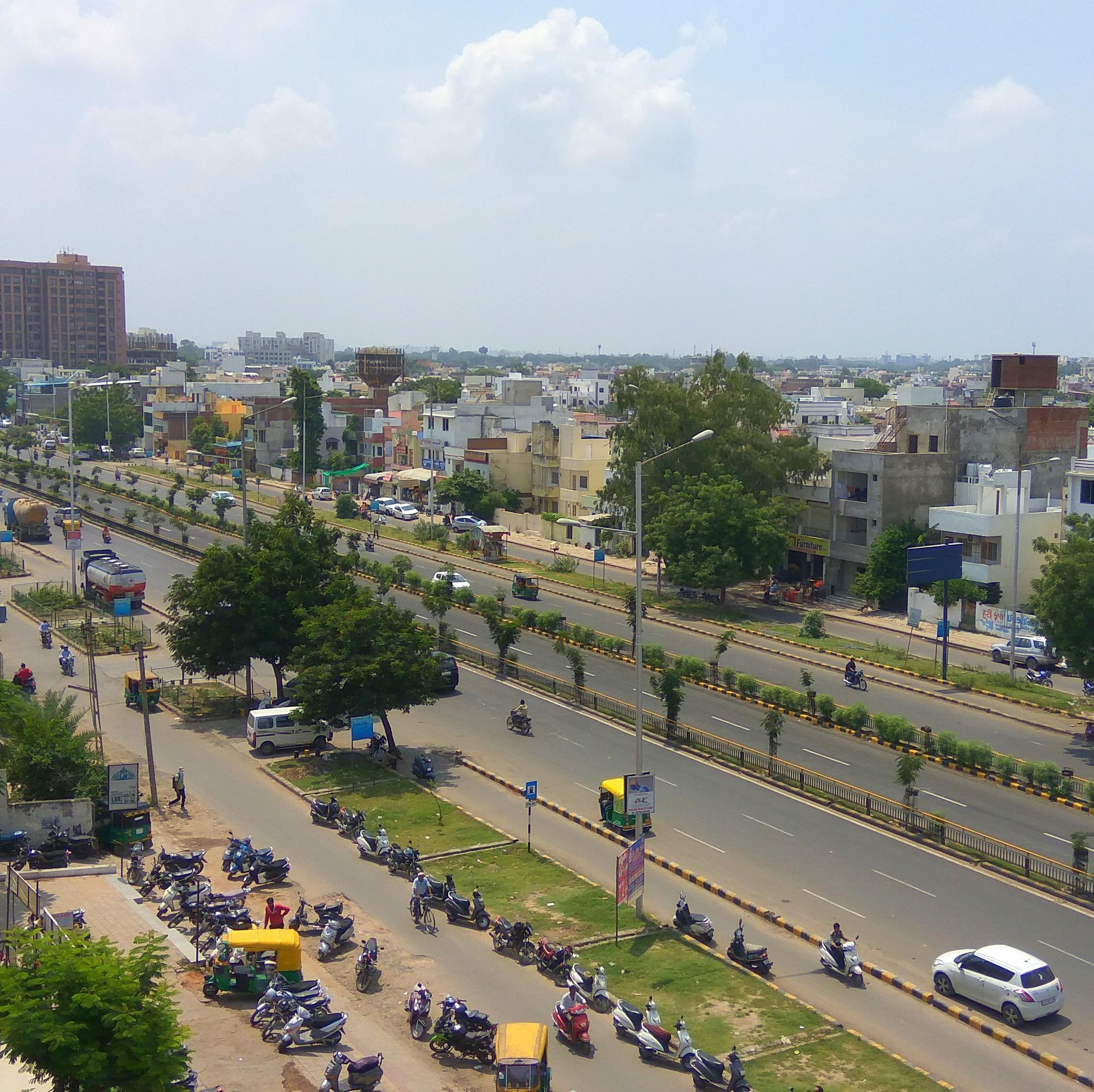
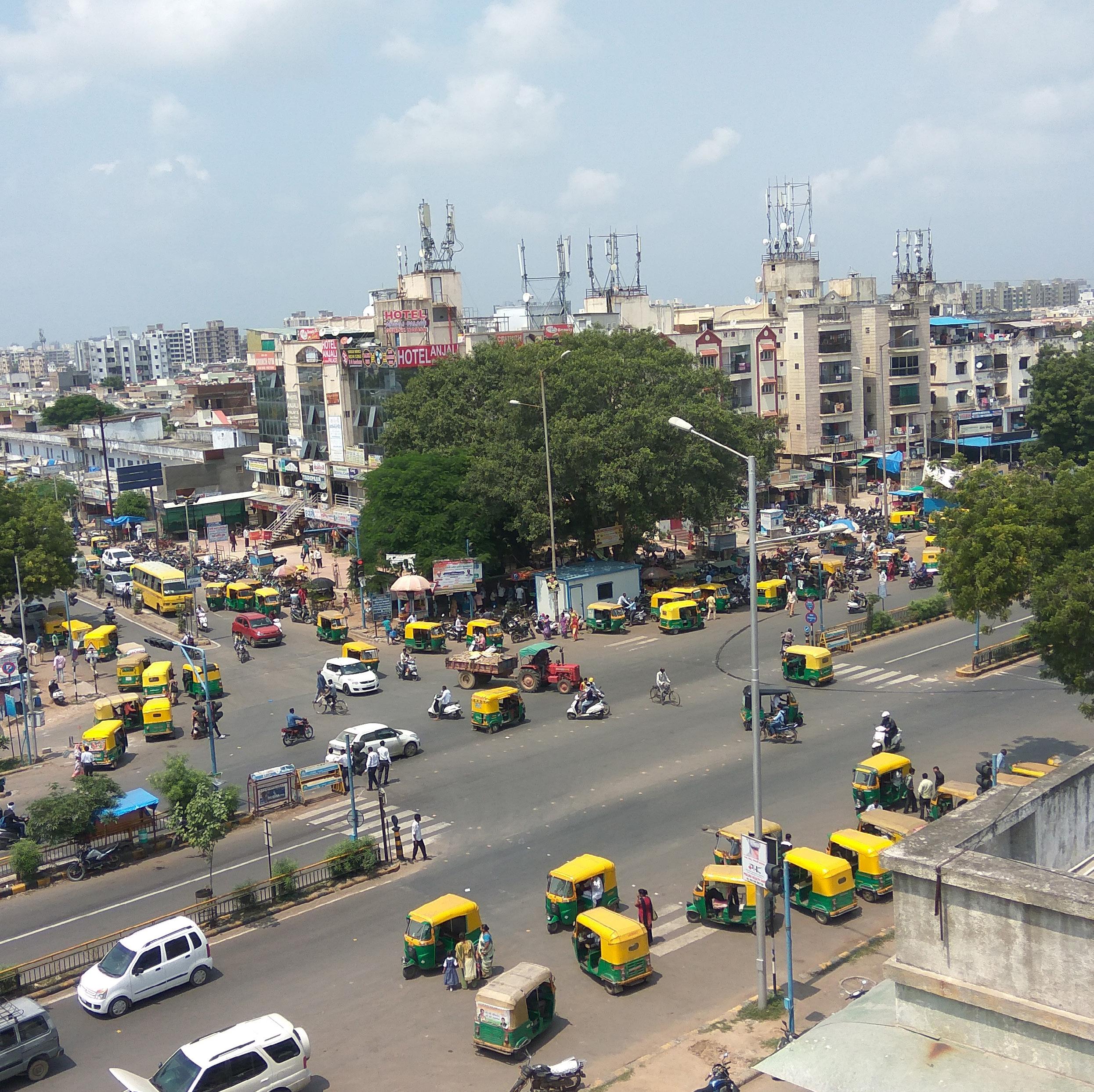
All photographs by authors unless otherwise mentioned
Cover design by Arundhati, Nidhi
Book design by Group
Text Editing by Nivedita | Tushar
Visual Editing by Arundhati I Darshan
Preface by Nivedita
Data from this book can be used and quoted with due acknowledgment to the authors and the studio.
115
key ideas
2 3
CONTENTS 01 Acknowledgement 05 Preface 07 Introduction to urban fringe 08 Situating Chandkheda 16 Chandkheda today 18 Voices of people
Transformative
20 References
ACKNOWLEDGEMENT
First of all, we would like to express our sincere gratitude towards our guides Prof. Vaani Herlekar and Mansi Shah, whose sincerity and support has been a constant source of inspiration. Their experience has been of great help in working on and reviewing each sub-part in this studio and we thank them for their patience and steadfast encouragement to complete this study. They were always available to clarify all our doubts and motivated us to achieve the best. We owe them lots of gratitude for having shown us confidence in this way of research.
We would like to take this opportunity to thank our Academic dean Prof. P.M. Phatak for having assisted us in this studio and guided us when necessary and also thank Prof. Neha Bhatt and Prof. Rutul Joshi for their valuable comments during the review and sharing insights for the relevance of study. We also thank all the other faculty members who spared time from their busy schedules to guide us whenever required.
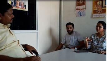
We would like to thank Vatsal Patel (Chief town planner), Ahmedabad Municipal Corporation, as well as Ward officer, Chandkheda (AMC), Arunsingh _ for sparing their time for the interviews and discussions and giving expert opinion which aided us in formulation of proposals.
Our families have been a constant pillar of support and we thank them for always having been there to guide and
PREFACE
help out when most needed. We are also grateful to our colleagues who were always there to guide us and help out when most needed. Last but not the least, we would like to thank our classmates for their enthusiasm, mental support and presence at all times required, which gave us the required motivation at all stages of the study.
I Nivedita
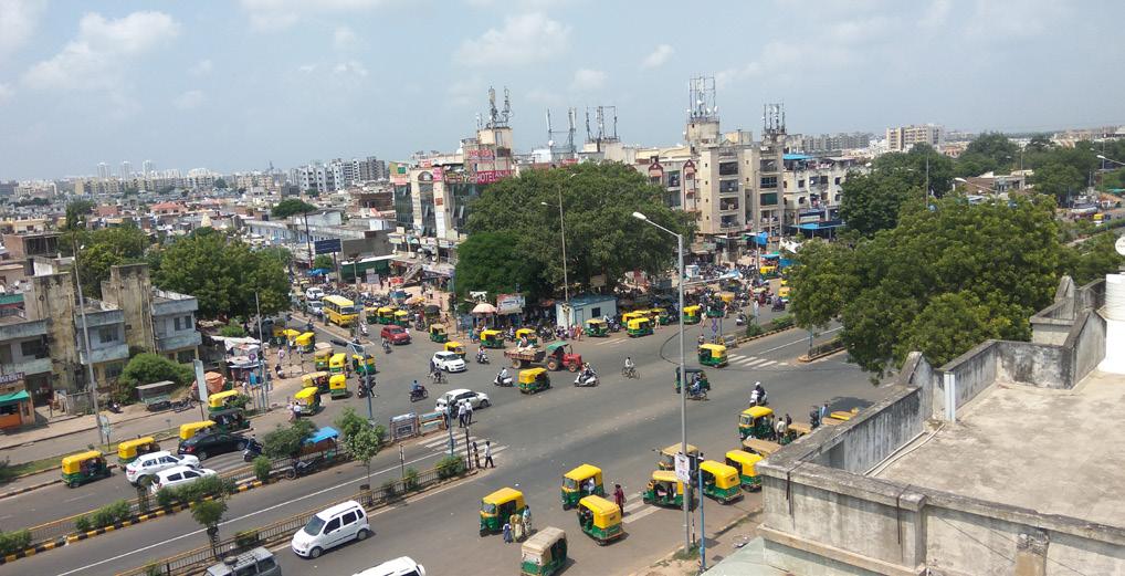
With increasing urbanisation, we are experiencing increasing populations, higher densities and declining green spaces. More than 50% of the population now resides in urban areas. Indian cities are rapidly growing outwards and this growth is accommodated in the suburbs and a rural-urban fringe is created.
Urban fringe, also referred to as rural-urban fringe is thus the transition area between the rural and urban areas. These fringe areas possess the characteristics of both: the city and the town, and do not have their own specific definition or limit. Any city does not grow outwards in a planned pattern. It develops haphazardly and thus fringe areas have been traditionally been looked upon as grounds for urban sprawl.
The fringe areas are characterised by presence of vast agricultural land, industrial estates, conversion of agricultural land for piecemeal development, lack of transport linkages, changes in land use, less traffic congestion and pollution, more amount of open space, etc. There is a constant pressure for new development as the land available is cheaper than that in the city centre.
Fringe areas are being looked upon as areas having large scope of expansion. Thus, various fringe areas of Indian cities such as Mumbai, Pune, and Bangalore
have started developing various key infrastructure projects in the fringe areas as these fringe areas of today are tomorrow’s city areas. These fringe areas are attracting more real estate investments and expanding rapidly. Yet, they face severe challenges that none of the Indian cities have been able to tackle.
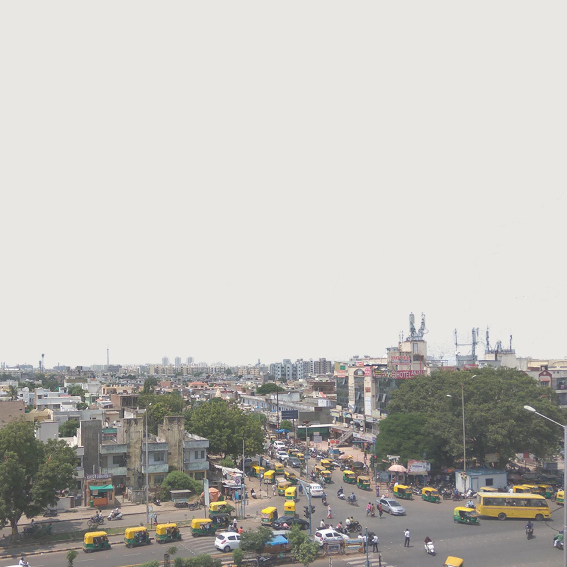
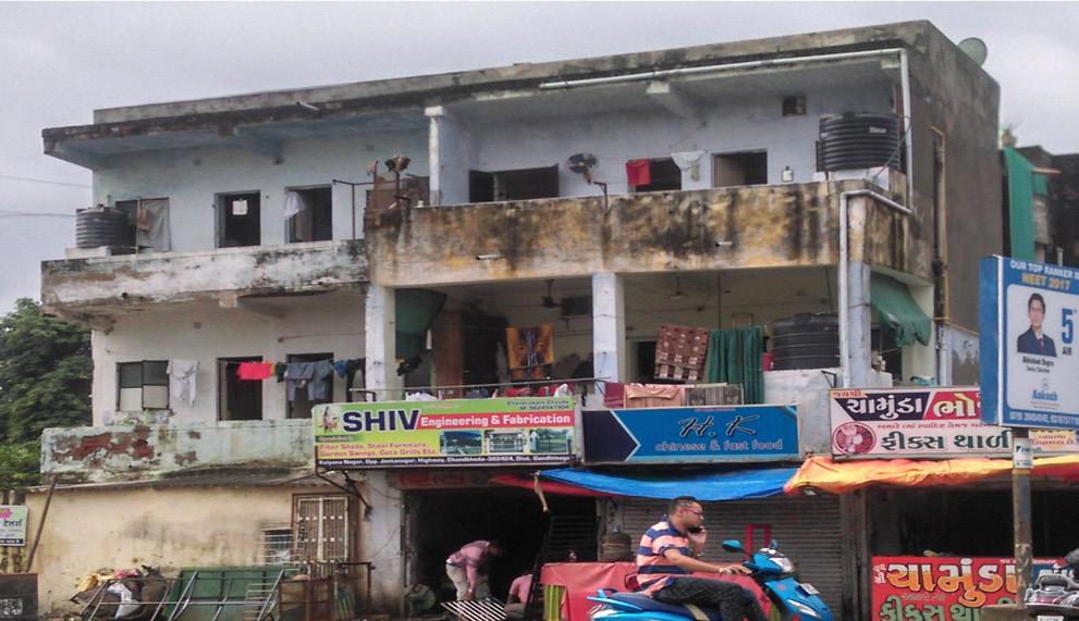
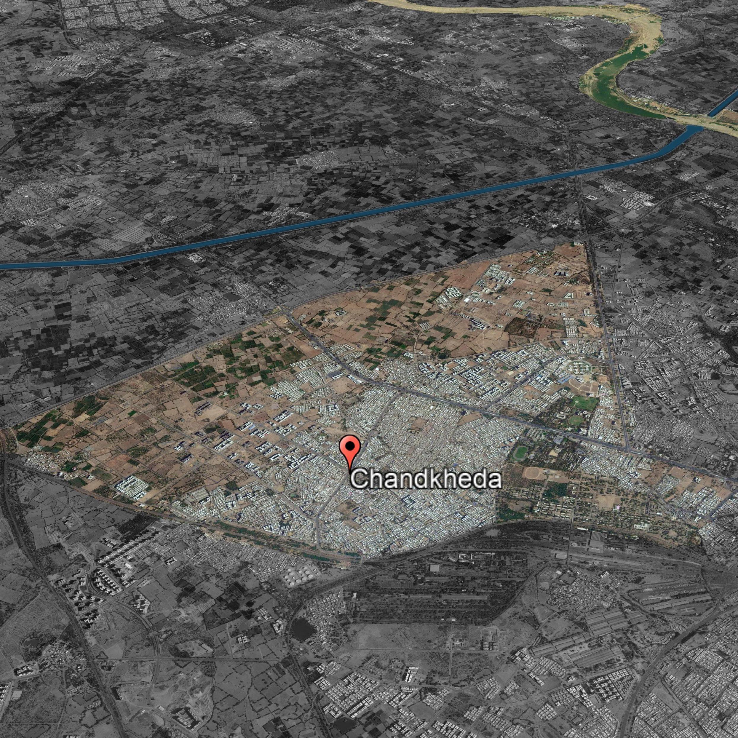
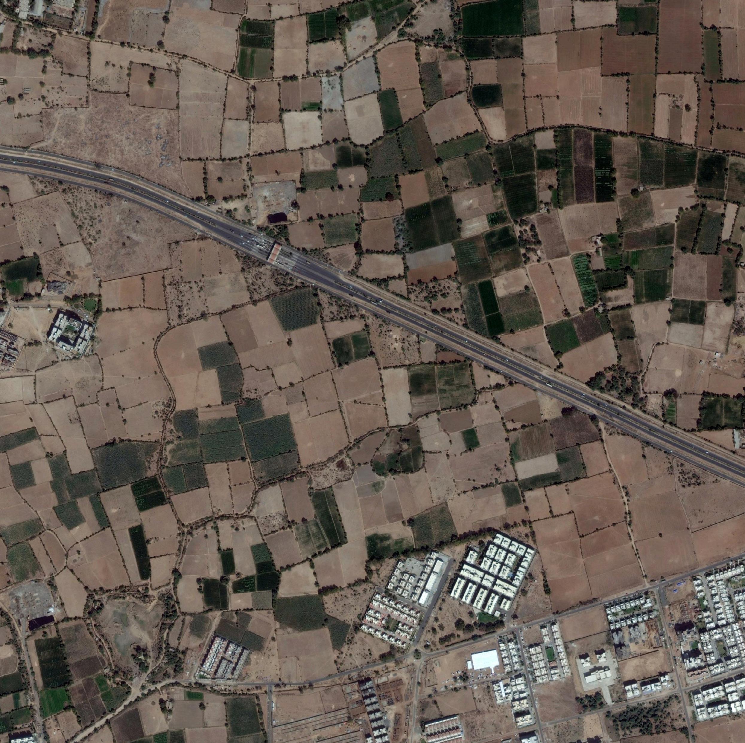
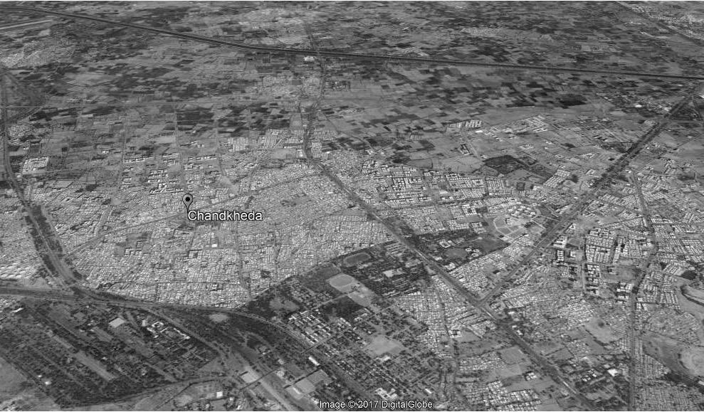
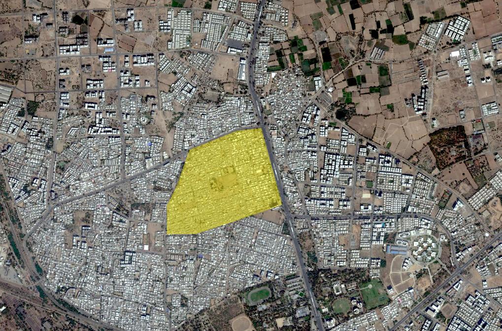
Chandkheda, a fringe area, located in the North West region of Ahmedabad city is a classic example of how fringe areas are emerging. Chandkheda falls in ward 4 of Ahmedabad city. It encompasses a population of 96,266 with an area of 16 km2 and population density of 88 persons per hectare. There are two major spines that connect Chandkheda to Ahmedabad city which are State Highway 41 and 71. Chandkheda essentially developed as a residential area due to the emergence of Oil and Natural Gas Corporation (ONGC). The major landmarks in the area include ONGC, VGEC College, Gujarat Housing Board and Chandkheda village (Gamthal). The challenges exhibited in this area include lack of public open spaces, haphazard development, absence of a systematic street grid network and poor NMT facilities. However, Chandkheda possesses potentials such as availability of low cost land, presence of a TOZ zone and good connectivity to Ahmedabad city.
4 5
INTRODUCTION TO URBAN FRINGE
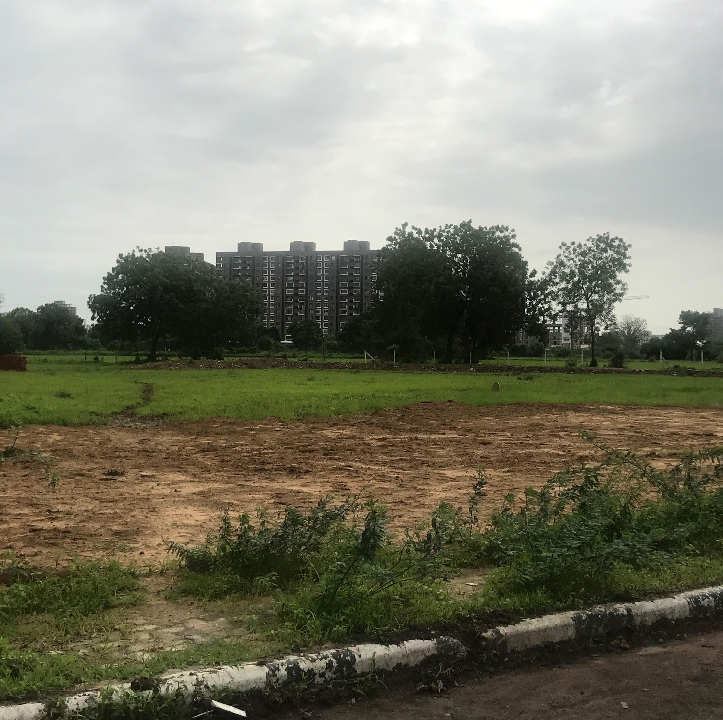
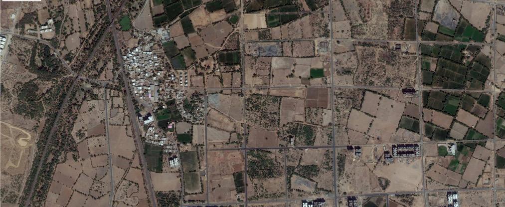
Urban fringe areas are the result of urbanisation. Urbanisation essentially means that an increasing number of people now live in urban areas. This increase in urban population is accomodated in the suburbs. Thus, fringe areas have traditionally been looked upon as grounds for urban sprawl. These urban fringe areas are typically characterised by presence of vacant low cost land, low density development, conversion of agricultural lands to piecemeal development and overlaps of multiple governing authorities.
Drivers of development
Cities are engines of economic growth. Economic growth and development of a city are directly connected to the level of urbanisation in that city. With the advent of rapid urbanisation, Indian cities are experiencing outwards spatial growth. This phenomenon is typically haphazard, scattered and low dense. This urbanisation has led to unorganised growth in our Indian cities. The increasing population growth is accomodated in the fringe areas due to availability of low cost and vacant land. Since land in city centre is scarce and highly priced, developers also prefer constructing in the fringe areas. In the absense of a plan, this growth will continue to expand in an unorganised manner.
Characteristics
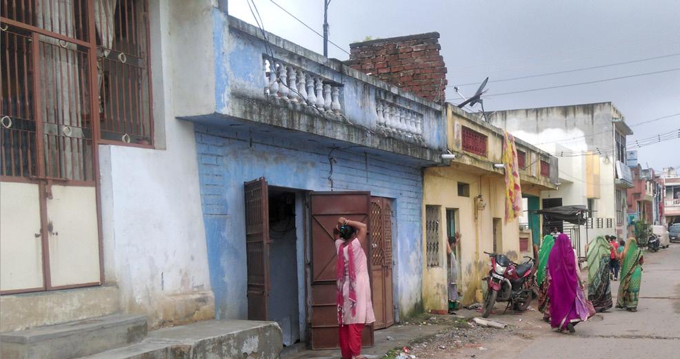
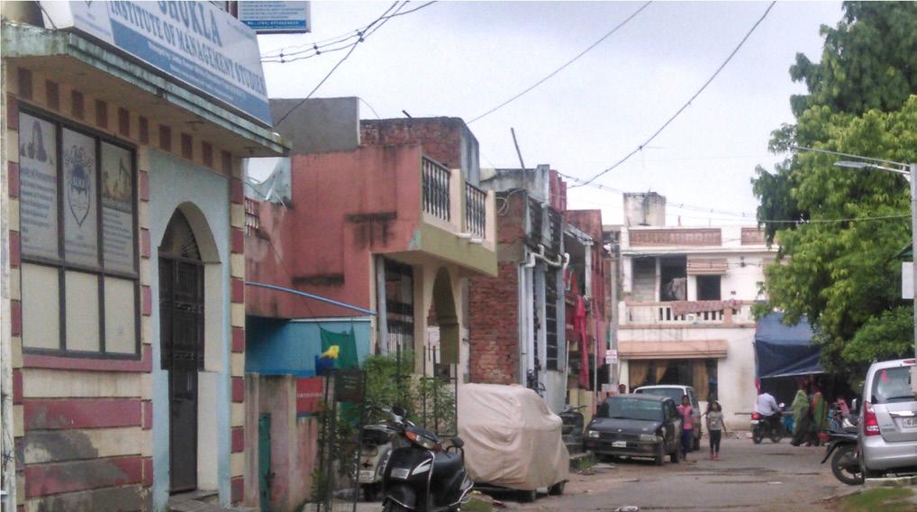
Fringe areas are typicaly characterised by presence of large amounts of vacant land. There is piecemeal conversion of agricultural land to haphazard and scaterred developments. Second key characteristic of fringe areas is largely privatised infrastructure. These include private acccess streets and water supply
systems like bore wells. This is an issue because it raises concerns of environmental sustainability. Another pertinent characteristic of fringe areas is overlap of multiple governing bodies unlike any other city centre area. This leads to lack of co-ordination and implementation of plans in these areas. In the absence of a plan, fringe areas are typically characteristed by ribbon development.
7
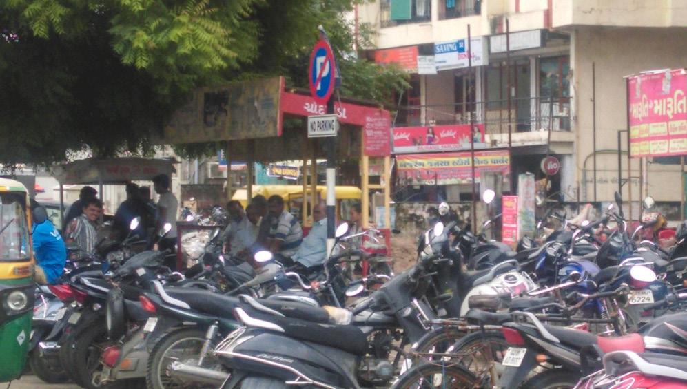
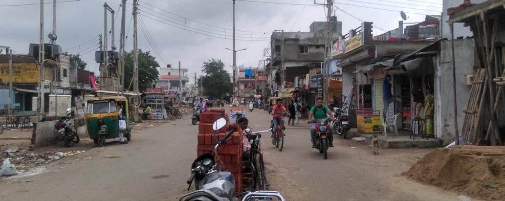
Fig 1: Privatised access streets in fringe areas
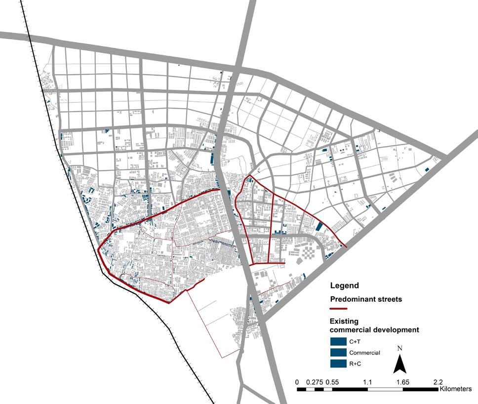
Managing growth in fringe areas through TP schemes in Ahmedabad
When we look at an urban fringe area of Pune, we can observe that all development is clustered around one single road with linear agricultural plots being converted to new developments. Ahmedabad, however, has been relatively successful in managing its fringe area owing to the TP scheme mechanism. TP scheme is a land pooling and readjustment framework which allows for reserving land for roads and public infrastructure.
Fringe areas of Ahmedabad
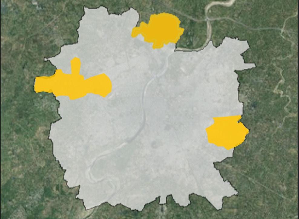
While we understand that Ahmedabad manages its fringe area through a TP scheme mechanism, we also compare different fringe areas in Ahmedabad. To understand the growth dynamics of Ahmedabad, we have compared three different fringe areas of Ahemdabad: Chandkheda, Thaltej and Vastral. The spatial growth in Thalej is very high as compared to the population growth. This indicates that there are more high income, low density bungalow typologies in Thaltej. However, when we look at Chandkheda, the spatial and population growth are comparable which indicate that it is a growing ward with medium income residential estates coming up.
SITUATING CHANDKHEDA
Location in Ahmedabad
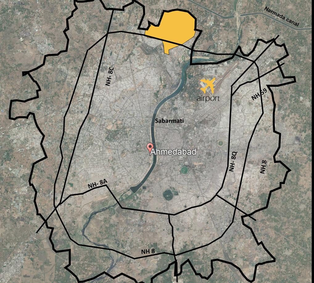
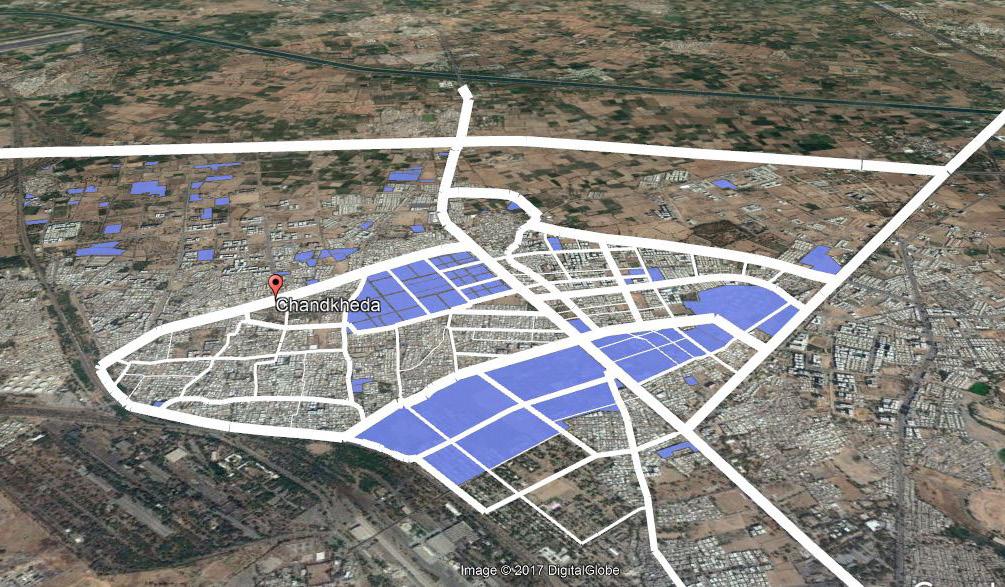
Chandkheda is located to the north-western boundary of Ahmedabad city. It is a fringe ward which was included in the AMC boundary in 2008. It is a growing ward with increasing spatial and population growth. It is closer to business centres like Gandhinagar (15 km) and GIFT city (16 km). It is also closer to the airport (14 km). Chandkheda is bounded by SP ring road to the north, SH 71 towards the east and railway line to the west. SH 41 runs north-south dividing Chandkheda into two parts. It is witnessing new developments due to lower land prices as compared to other fringe areas of Ahmedabad. Thus, it is primarily residential. There is also presence of Gamthal (Chandkheda village) which forms a major aspect when we look in terms of the features in Chandkheda.
Location: North- western boundary of Ahmedabad
Population: 96,266
Area:16 sq. km
Population Density: 88 persons per hectare
Ward: 04
Ward Councillor: Arunsingh Ramannayan Singh
Land Prices:
Key Landmarks: Gujarat Housing Board, VGEC college and ONGC.
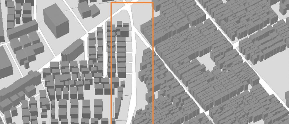
Delineating the Study Area
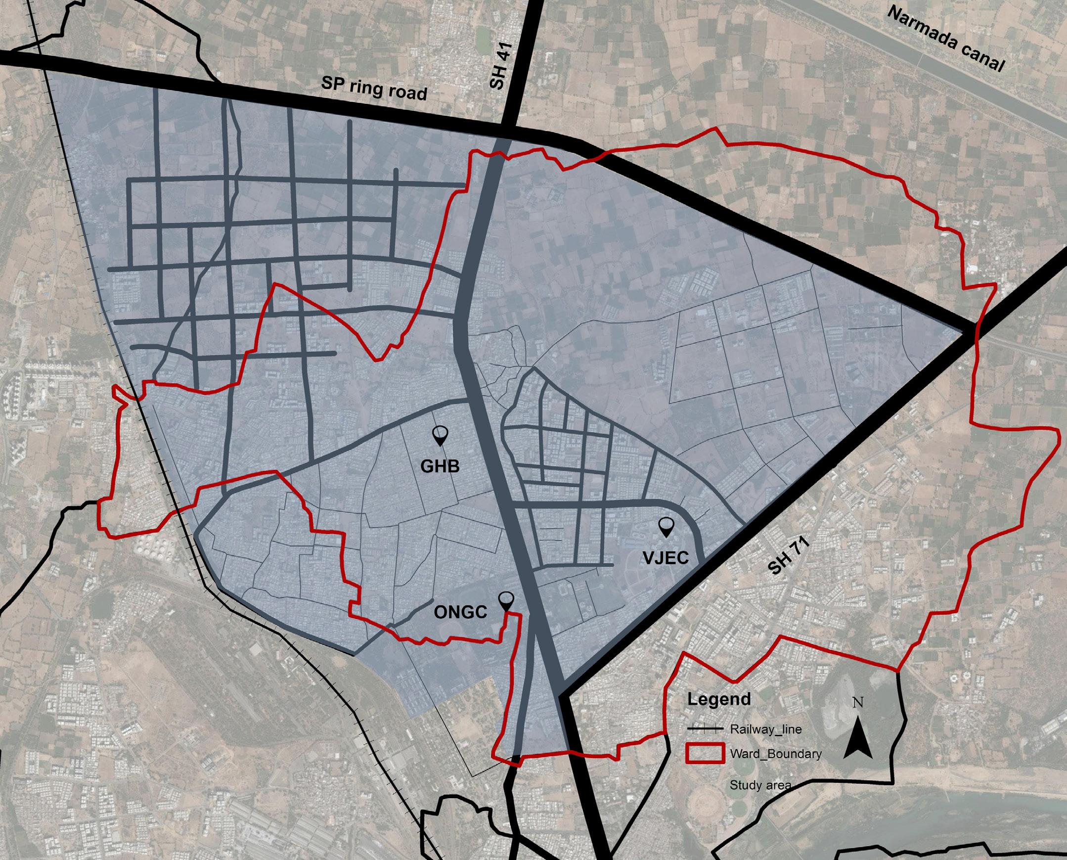
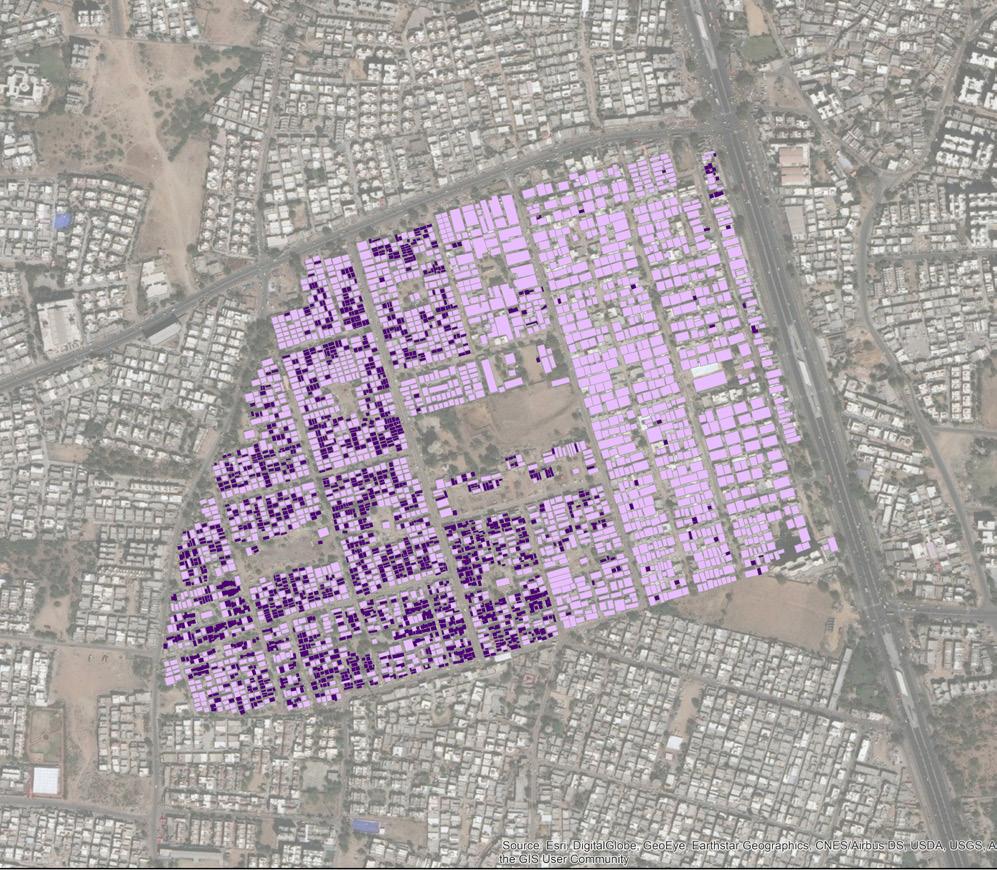
The ward boundary of Chandkheda is not solely considered for the study purpose. A new study boundary is delienated for this studio exercise. The Study area is defined by major arterials, towards north bounded by SP ring Road, SH 41run across the ward ,on the east it has SH7 and on the other side by the railway line.The ward has overlap of Jurisdictions.It lies between AMC & AUDA Boundaries. Within AMC, it covers wards 01 (Gota) and 03 (Kali).
8 9
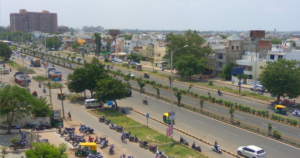
Fig 2: An urban fringe area of Pune
Fig 3: An urban fringe area of Ahmedabad Fig 4: Fringe areas of Ahmedabad
Fig 5: Location of Chandkheda in Ahmedabad
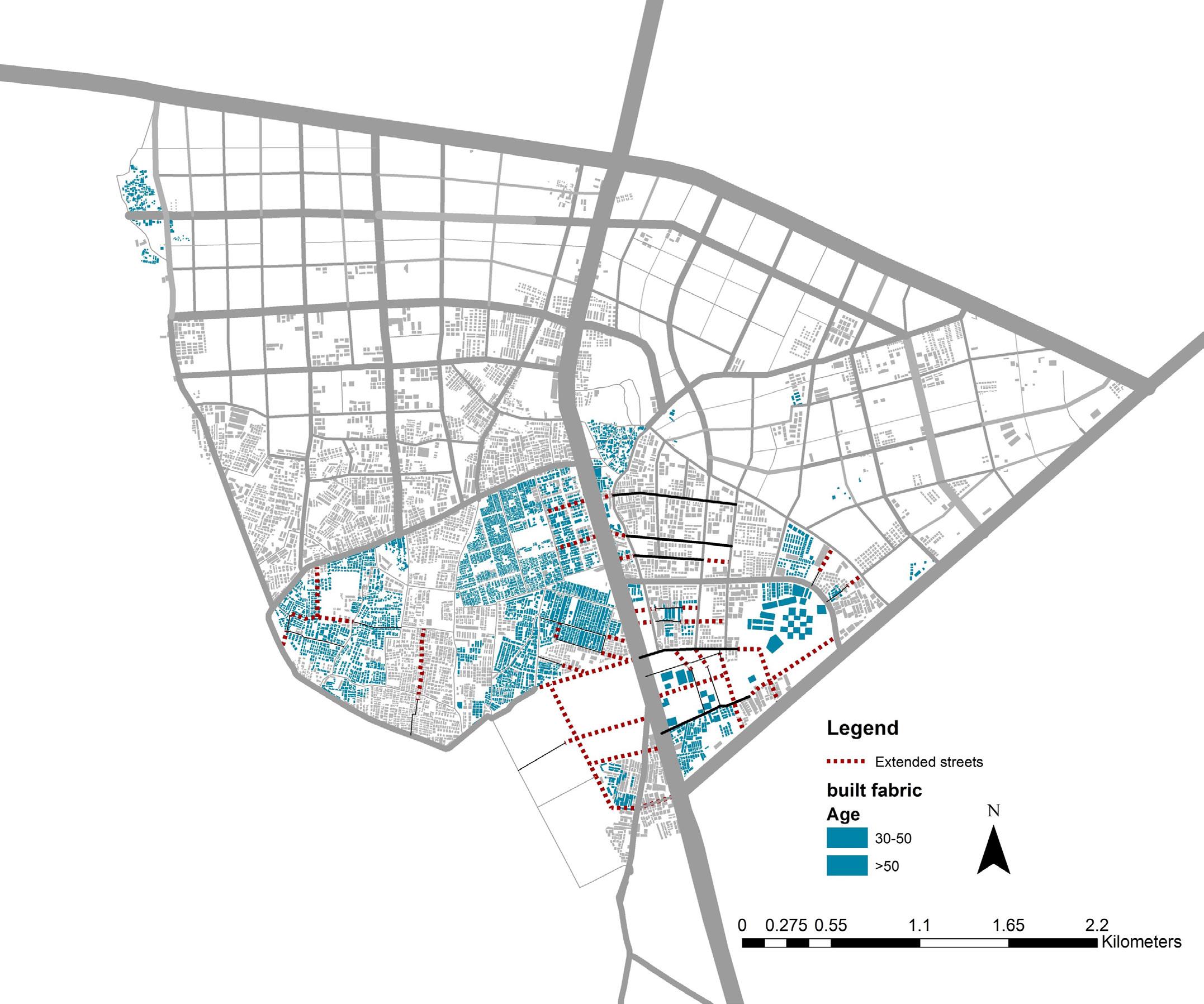
KEY SPATIAL CHARACTERISTICS
This section presents key spatial characteristics related to streets and connectivity, land development, and built fabric. The characteristics are presented through maps and related analysis.
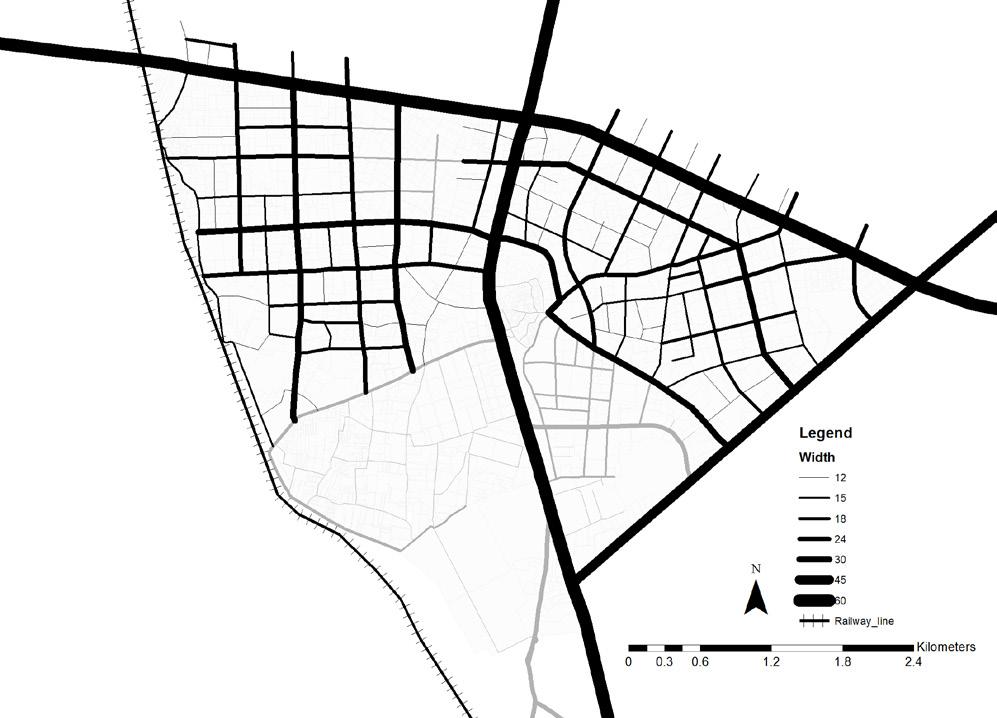
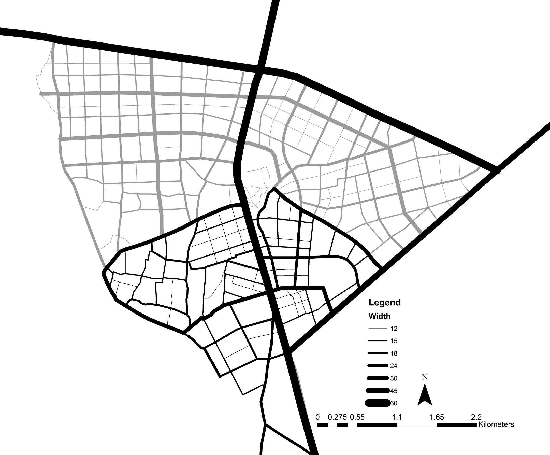
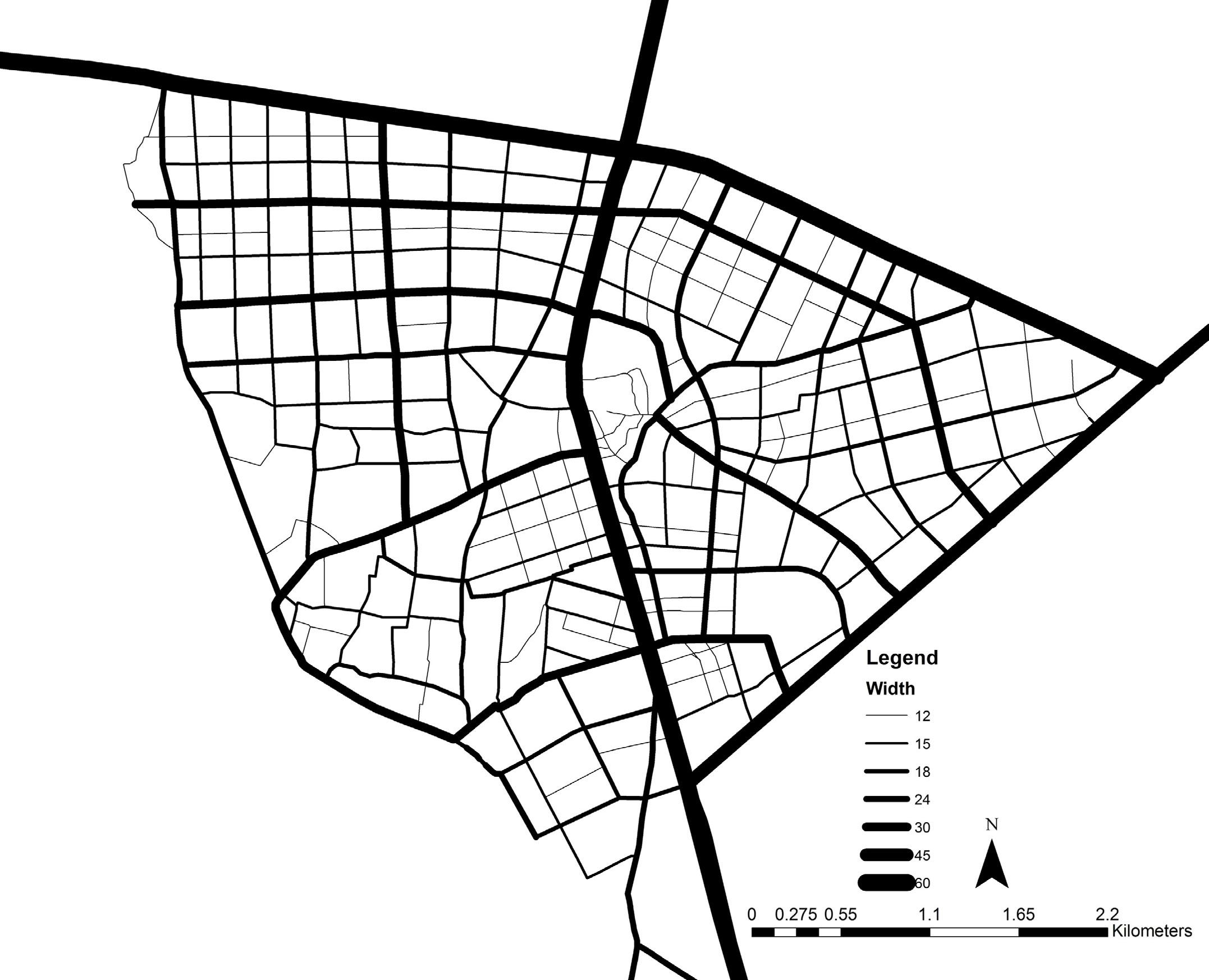
1. Street network and connectivity
Chandkheda has a prominent street network, with good regional conectivity through major arterials. Internal street network has emerged due to inorganic built fabric. In few areas, new streets are being laid through TP scheme.
2. Land development
Land characteristics consist of 4 key aspects, which include an assessment of vacant vs developed land, public and private land ownership, land use patterns as well as land parcel sizes.
3. Built fabric
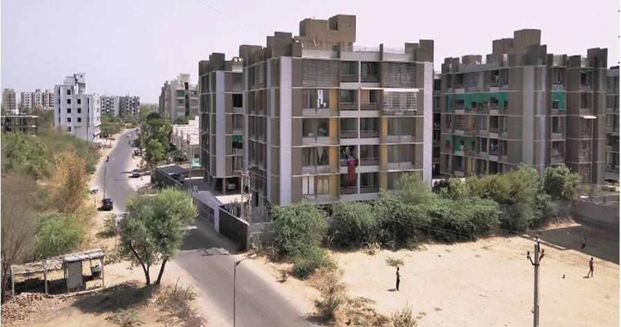
As a developing fringe, Chandkheda has various typologies of built fabric. It majorly consists of detached and semidetached houses. Row houses and apartments are emerging since the past 10-20 years.
10 11
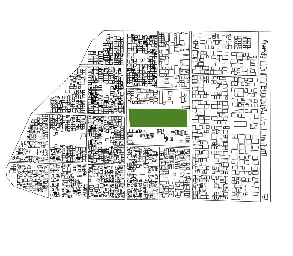
Fig 6: Study area delineation
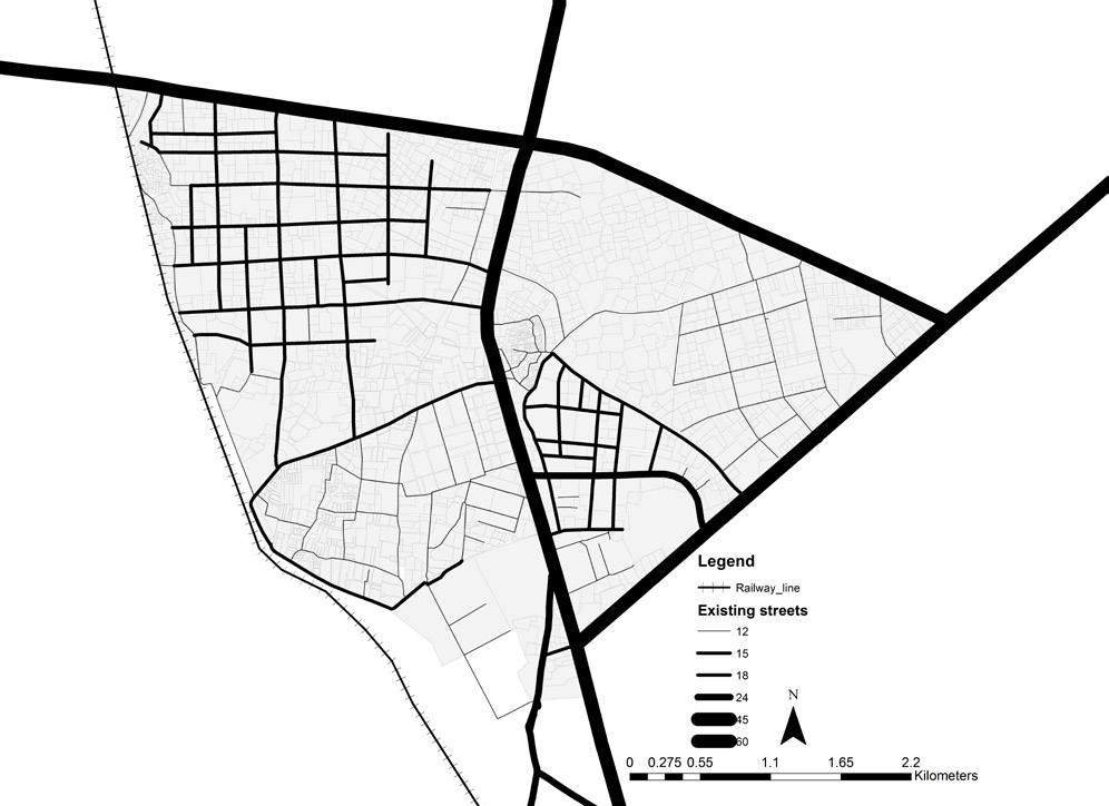
STREET NETWORK
Chandkheda offers a relatively good regional connectivity through arterial SH41. Denser street network is present in the south-west region.New streets are being laid through TP scheme in the northern periphery.
21.0% area under streets, of which,
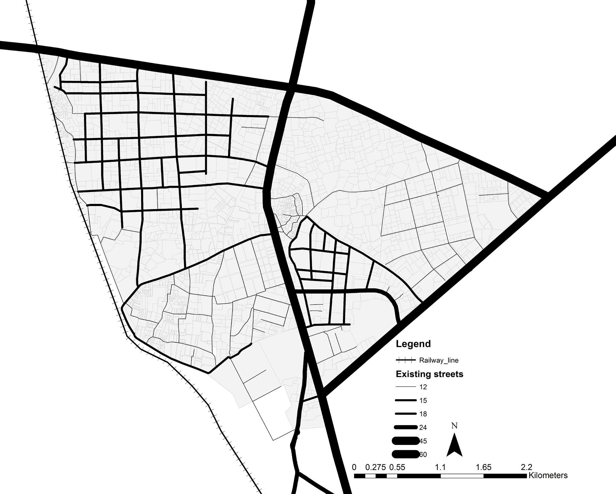
03.1% under Arterial roads
03.0% under Sub-Arterial roads
03.9% under Collector streets
11.4% under Local streets
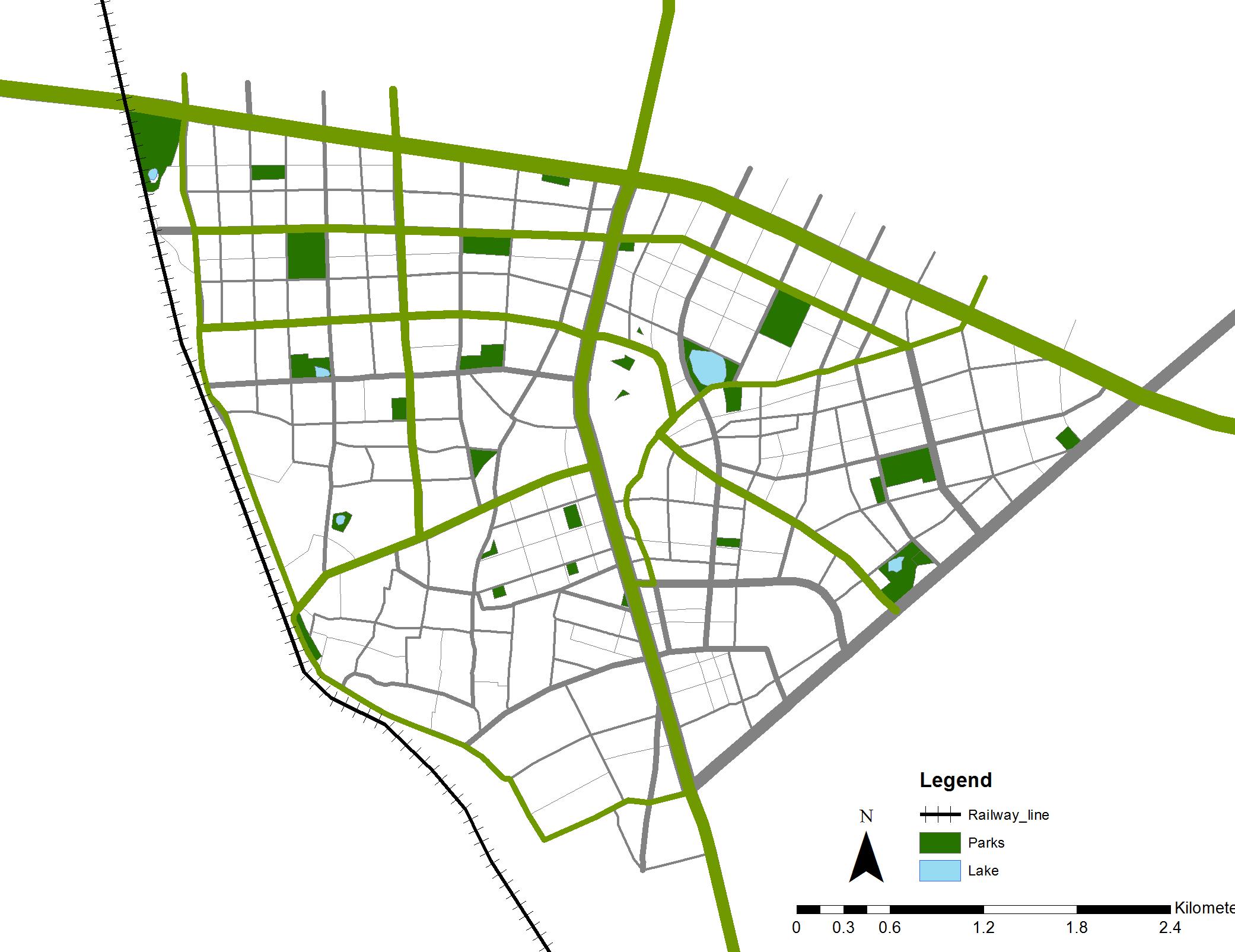
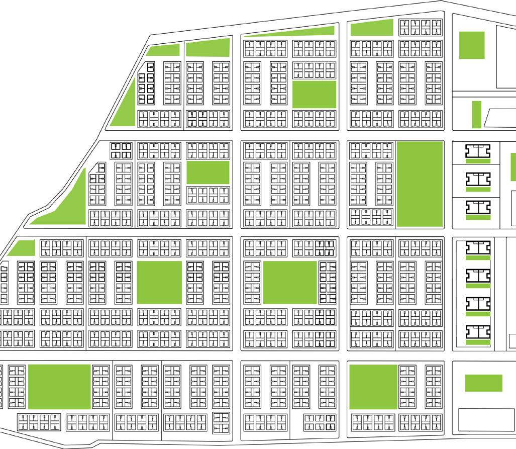
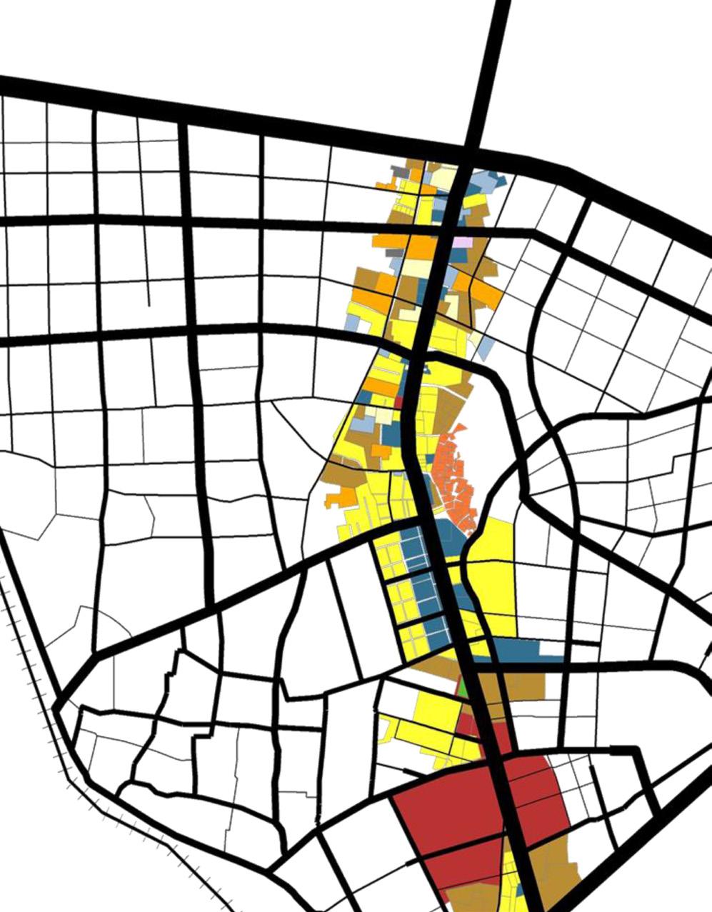
LAND USE PATTERNS
The land use patterns show that residential area is predominant.There are large institutions like ONGC and VGEC to the south. There are commercial activities along SH 41. Recreational spaces account for only 2.1%.
45% area under residential use
29% area under vacant land
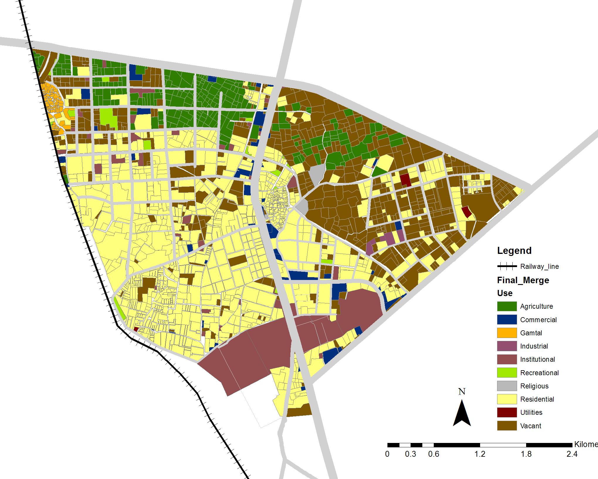
11% area under agricltural use
09% area under institutional use
02% area under recreational use
12 13
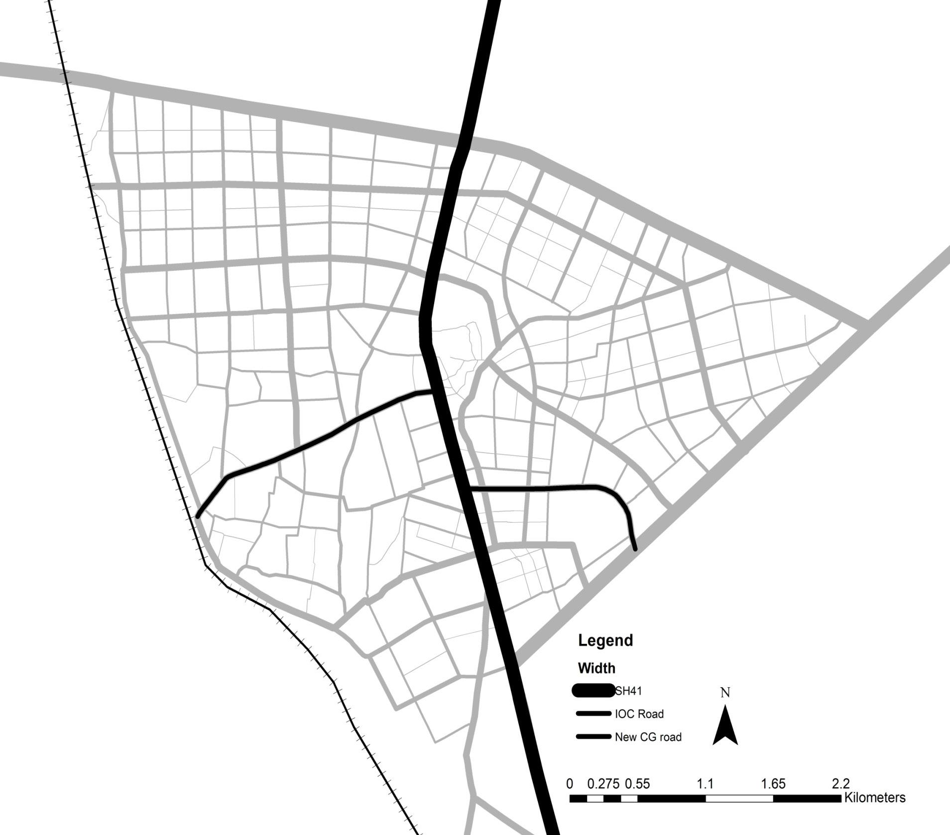
SH71
SH41 IOCroad New CG road SP ring road
Fig 7: Existing street network Fig 8: Land use
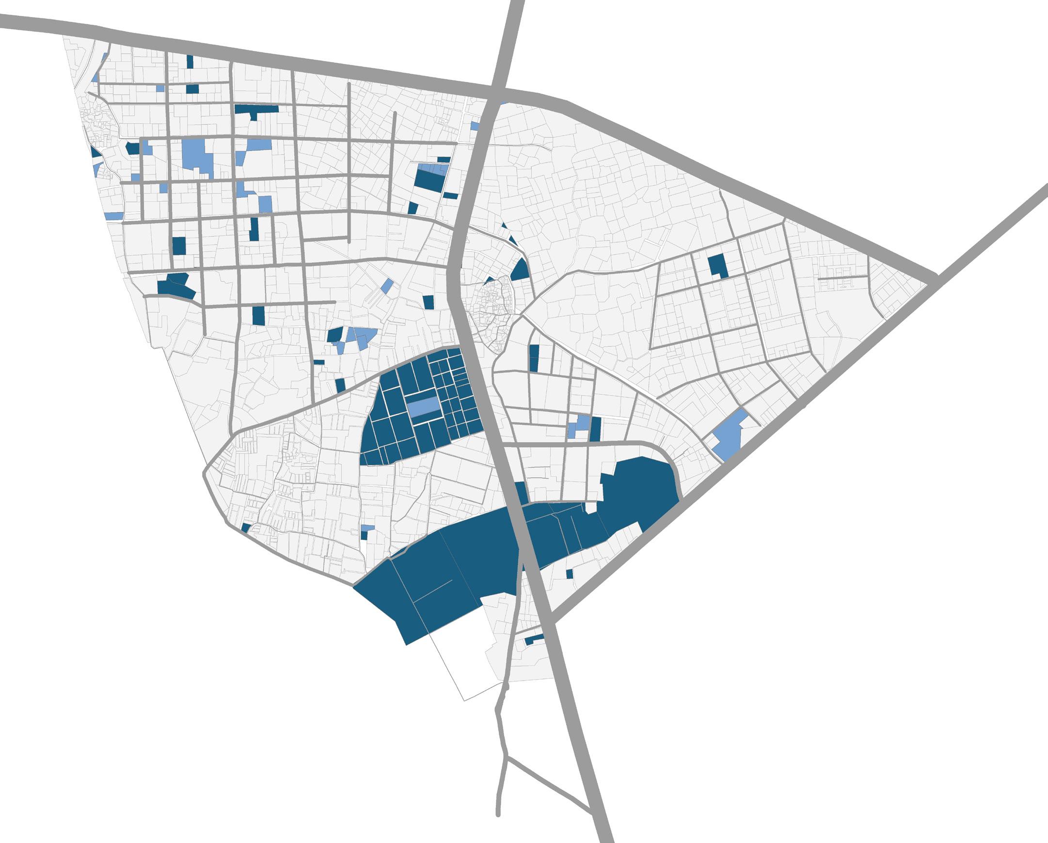
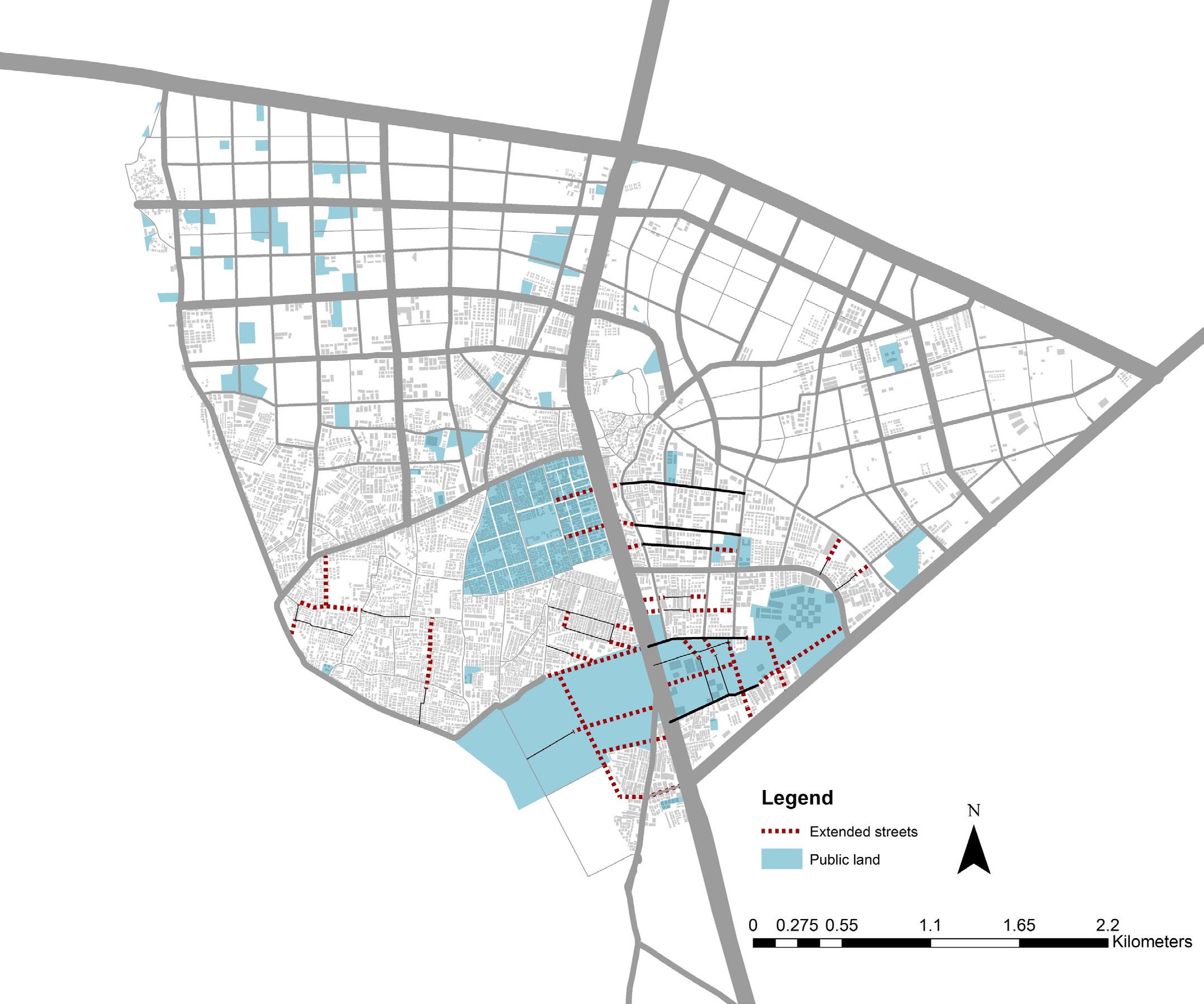
LAND UNDER PUBLIC OWNERSHIP
Most of the public vacant land is situated in the northern periphery.20% of land comes under public ownership. ONGC, VGEC and GHB are three biggest public land owners.
20% under public ownership, of which,
15% under public built
05% under public vacant
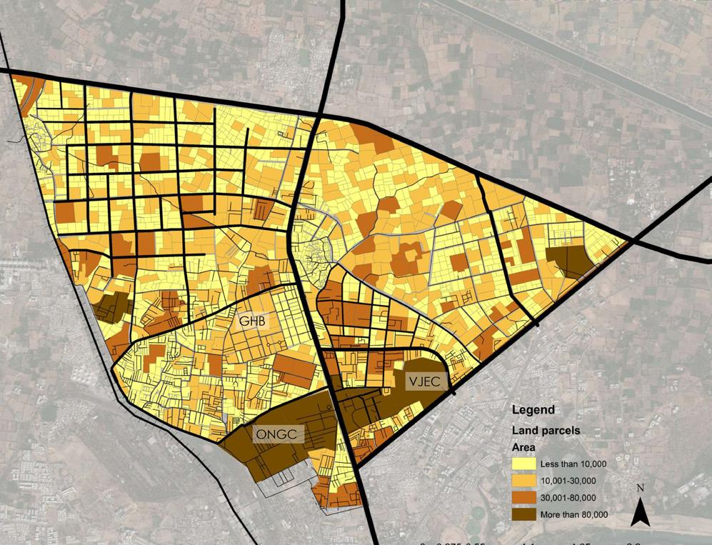
LAND PARCEL SIZES
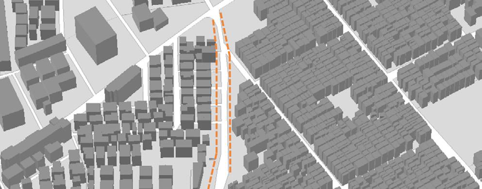
The southern area consists of large land parcels which are causing large block sizes. There are smaller land parcels along the transit corridor (SH41) which do not permit and incentivize high-rise development.
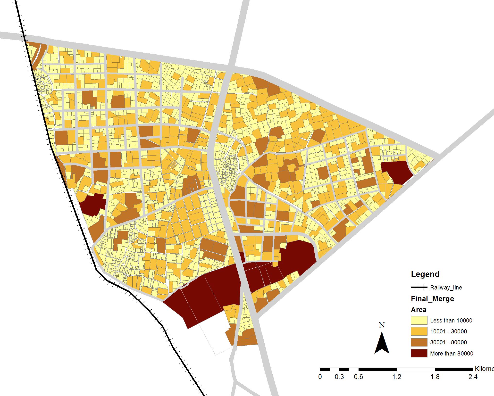
75% area under parcel size of <10,000 sq.m
14 15
Fig 9: Land ownership map
Fig 10: Land parcel size
DEVELOPMENT ZONES AS PER DP 2021
Ahmedabad DP 2021 defines what kind of development will come up in the area through different zones. As we move towards fringe area, FSI and density norms decrease.
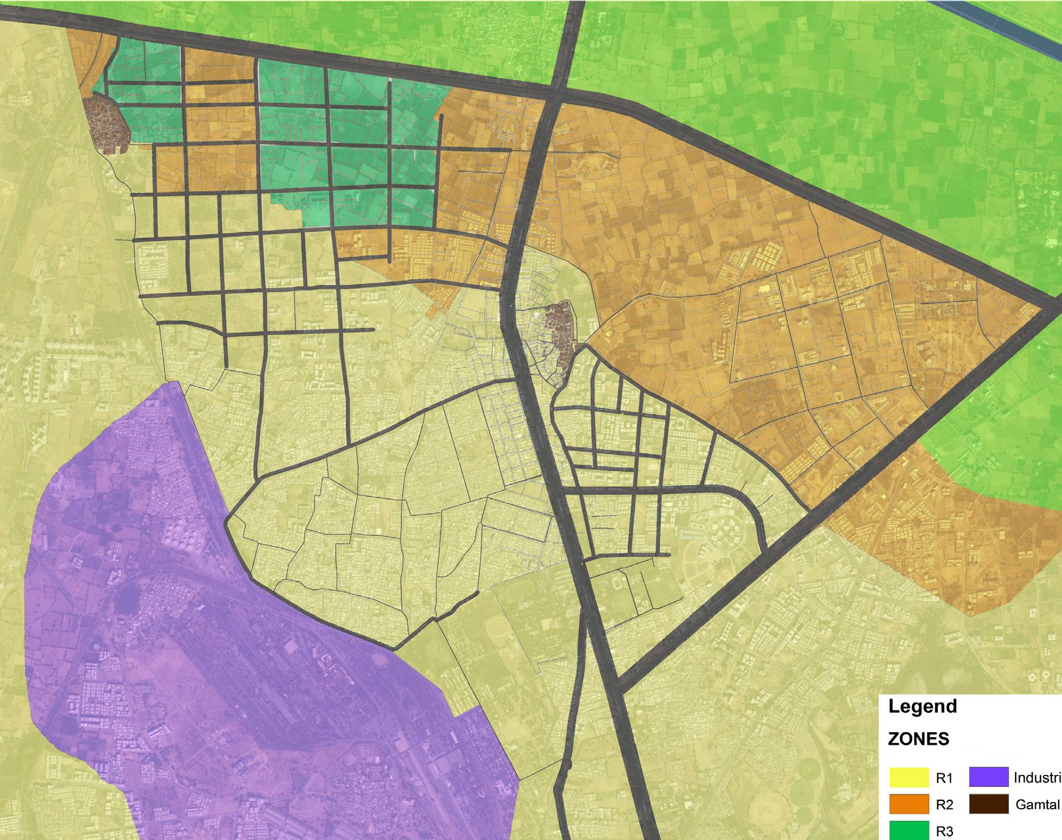
50% comes under R1 zone
43% comes under R2 zone
06% comes under R3 zone
01% comes under Gamthal zone
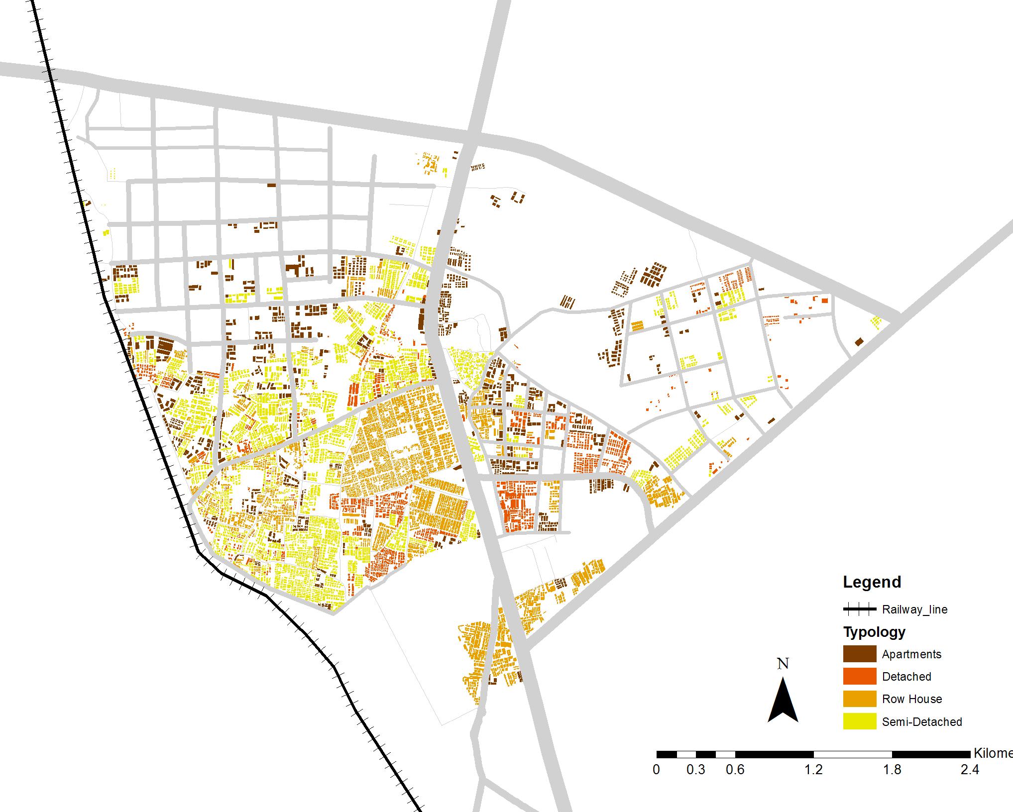
PREVALENT RESIDENTIAL TYPOLOGIES
The residential typology shows highly predominant semidetached typology. Most of the tighter construction took place in the south-west region with highly low-rise builtfabric. High-rise fabric is developing in northern periphery.
45% comes under semi-detached typology
35% comes under row houses
11% comes under detached
09% comes apartments
16 17
Fig 12: Resident typology
Fig 11: Current DP zone
CHANDKHEDA TODAY
Potentials
Since 29% of land in Chandkheda is vacant, it can be used as a potential for future development owing to its low cost.
Issues
There is a scope for redevelopment in Chandkheda due to a defined TOD zone in Ahmedabad DP 2021.
Chandkheda possesses good inter-region connectivity through SH41 and SH71. It also possesses strong intra-region connectivity.
Owing to the organically developed dense built fabric in Chankheda, there
However, the issue with vacant land is there is no systematic street network in the fringe area which leads to haphazard growth
Inspite of the TOD zone in DP, there exists poor public realm and lack of incentives for redevelopment. Thus, low rise fabric with informal parking exists.
Inspite of this good connectiivty, there exists poor accessibility because of inadequate pedestrian and NMT infrastructure
However, this dense built fabric still exhibits dilapidated conditions and lacks good building conditions
18 19
VOICES OF PEOPLE
Analysing public and private stakeholder interests
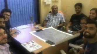
Stakehlder consultation was carried various stakeholders including their perspective, views on the development/ transformation of the area, key concerns, priorities to understand the ward from their perspective.Particular stakeholder’s interest in the specific area helped in understanding various aspects of the ward. Few quotes have been mentioned from stakeholders in order to describe their challenges and potentials of the ward or ways to develop the area.
“Ahmedabad today drives the hopes of a modern Gujarat. So,our aim is to serve maximum people and have end mile connectivity”
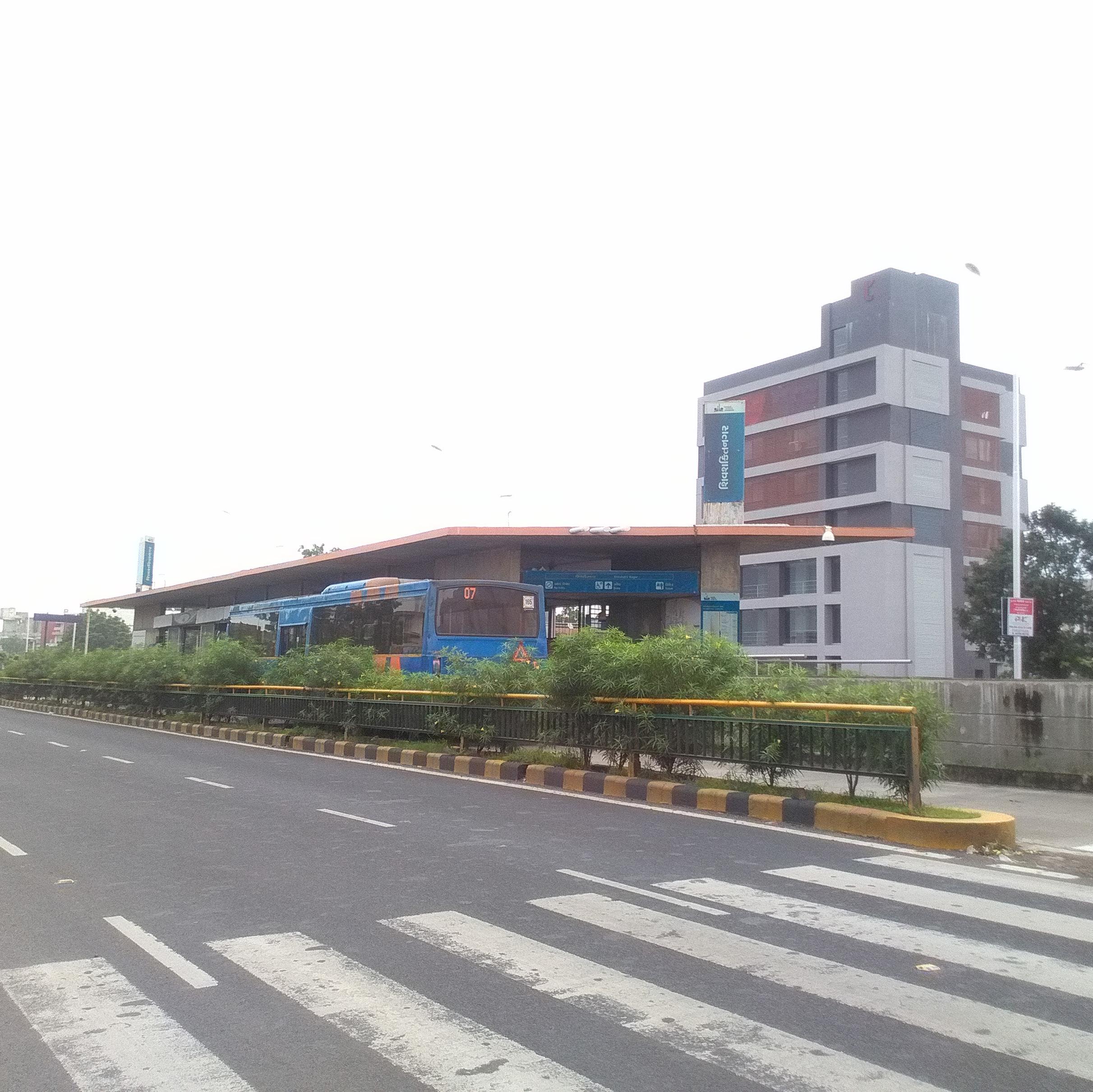
“Most metro investment seems to be in thin air. There is hardly any density to support even the BRTS network. This is no Mumbai where people cannot commute by private vehicles.”
“The main challenge faced in urban fringe areas of Ahmedabad is that the rate of development is surpassing the rate at which government can employ resources and provide services to the people”
-Mr. Vatsal Patel Town planner, AMC

“We try to incorporate as many as possible government policies, schemes in the area like laying Narmada network will resolve the water supply concerns and much more to provide facilities to the people.”
- Arunsingh Ramannayan Singh Ward councilor of Chandkheda,Ahmedabad
“The life of gamtal has an essence of undying culture. Hence we do not want any redevelopment. Gamtal is self-sufficient, though with better infrastructure it will cater to the increased needs of people.”
- Mangalaben Jodhawat Resident of the GAMTAL city
“We feel unsafe at night because there is nothing on these roads except for buildings under construction. There have been reports of chain snatchings by the construction labourers”
20 21
- Mr. Kunal Prikh Member of COE (Centre of Excellence in Urban transport)
Akshay, Himanshu, Boni and Doctor Vyas Regular BRTS commuters
- Mr Rathod, Resident of Gujarat Housing Board
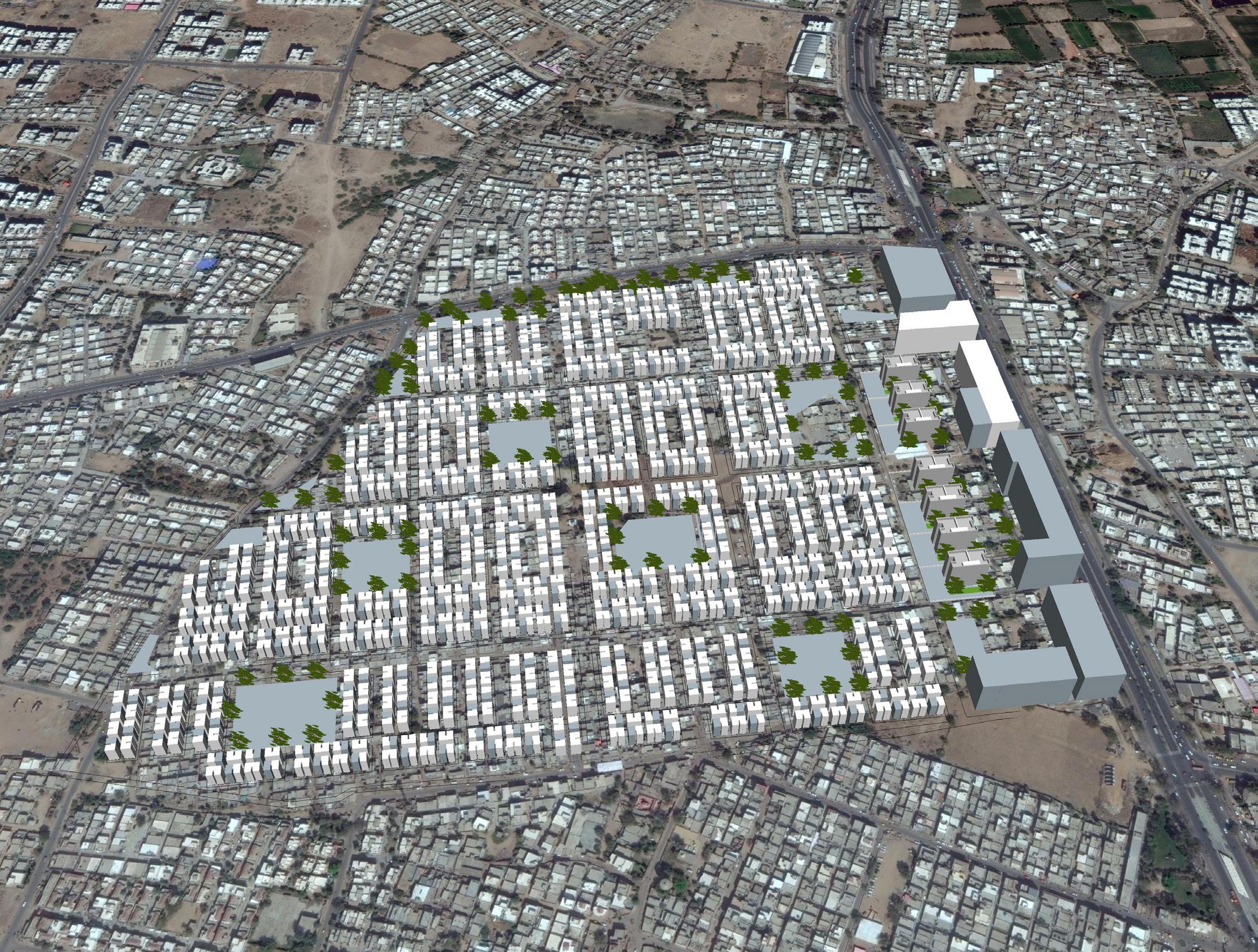
TRANSFORMATIVE IDEAS
A PLAN FOR TOMORROW
In order to address the challenges and issues in the area, our key ideas will mainly focus on two aspects: street network and redevelopment in the area.
The first key concern that we are solving is that since it’s a fringe area, we are looking at an organised street network for future growth. Second, though it’s a fringe area, there are lot of residential neighbourhoods which have come up organically with poor street connectivity. So we are looking at how we can improve street connectivity as well. Related to that, once the streets are carved out, we need to ensure that these are streets for all and have a good pedestrian access. So our third idea deals with improving pedestrian accessibility overall.
The last two ideas are ideas that foster redevelopment in the area. The first one we are dealing with an existing dilapidated public housing situated right on TOD and how it can support redevelopment and the second is through regulations how we can foster more
Facilitate organised growth in the fringe area using tp scheme as a mechanism
Improving existing street network to strengthen the internal street connectivity
Improving the pedestrian infrastructure with redesigning the pedestrian infrastructure
Support mixed-use, mix income development in gujarat housing boad public housing at a higher density
Support transit and pedestrian friendly development along sh-41
23
01. 02. 03.
04. 05.
01. A FRAMEWORK FOR ORGANIZED GROWTH
Facilitate organised growth in the fringe area using TP scheme as a mechanism
25
OVERVIEW
Key characteristics and challenges
There are two key characteristics which define growth in the fringe areas. Firstly, there is conversion of agricultural lands to piecemeal development. In the absence of a plan, individual farmers sell it to developers leading to piecemeal development. Secondly, infrastructure is largely privatized. This implies that there is no public infrastructure and people use their individual resources. Fringe areas are looked upon as grounds for spatial expansion due to availability of low cost vacant land
These areas also possess major challenges such as lack of systematic street network and public infrastructure in place, piecemeal and haphazard unplanned development. However, in the absence of a plan, this scenario will continue which is why we need to pay attention to these areas.
Ahmedabad and its fringe
Ahmedabad has been relatively successful in managing its fringe areas owing to the TP (Town Planning) scheme mechanism. TP scheme mechanism is a framework which allows for fair land readjustment and infrastructure building. It is a land pooling system in which all stakeholders have equal gains and equal losses. This framework reserves some percentage of land completely dedicated for public amenities and infrastructure. It allows the authorities to plan for the fringe areas in advance before their haphazard expansion.
ISSUES, OPPORTUNITIES AND CHALLENGES
Development expanding into farmlands
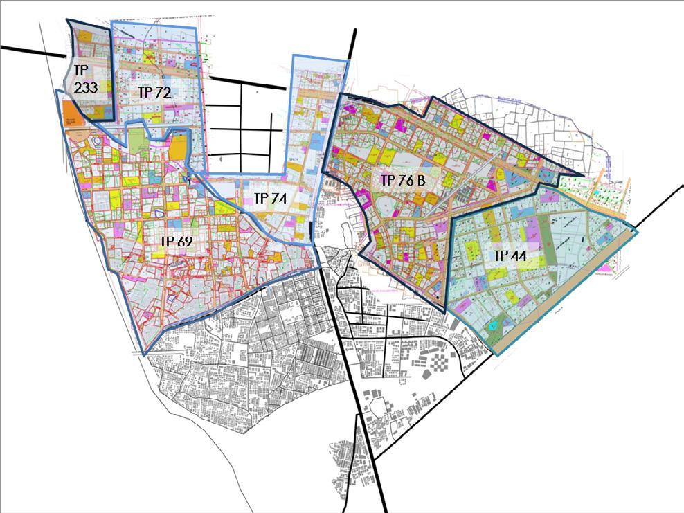
Most of the vacant land is situated in the northern periphery of Chandkheda. There have been TP schemes prepared and announced but not implemented. All new constructions in the past 10 years have expanded into the virgin farmlands. Thus, in the absence of implementation, several lands are bought by developers leading to piecemeal development. In the absense of a plan, the individual agricultural plots are being converted into piecemeal development. Planning and laying a street grid network allows for organized growth in the fringe areas well before the actual development starts coming up in the area.
Potential for improvements in proposed TP schemes
Currently, there are six TP schemes in the area. However, they have not been implemented completely. Looking at these six TP schemes comprehensively would lead to an integrated street network and public infrastructure in place.
26 27
Figure 13: New private developments coming up in the area
Figure 14: TP schemes proposed in the area
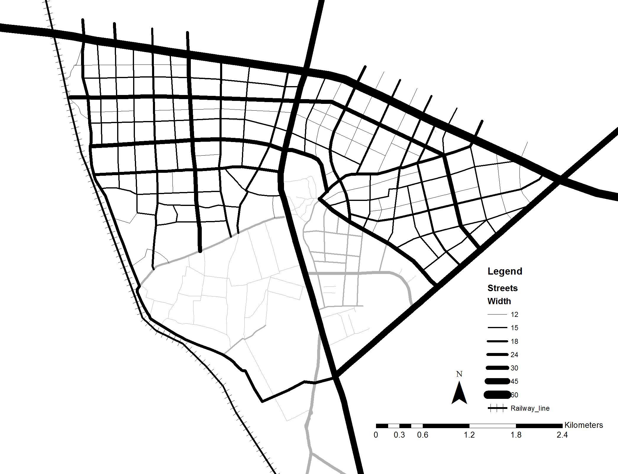
Potential for improving street network
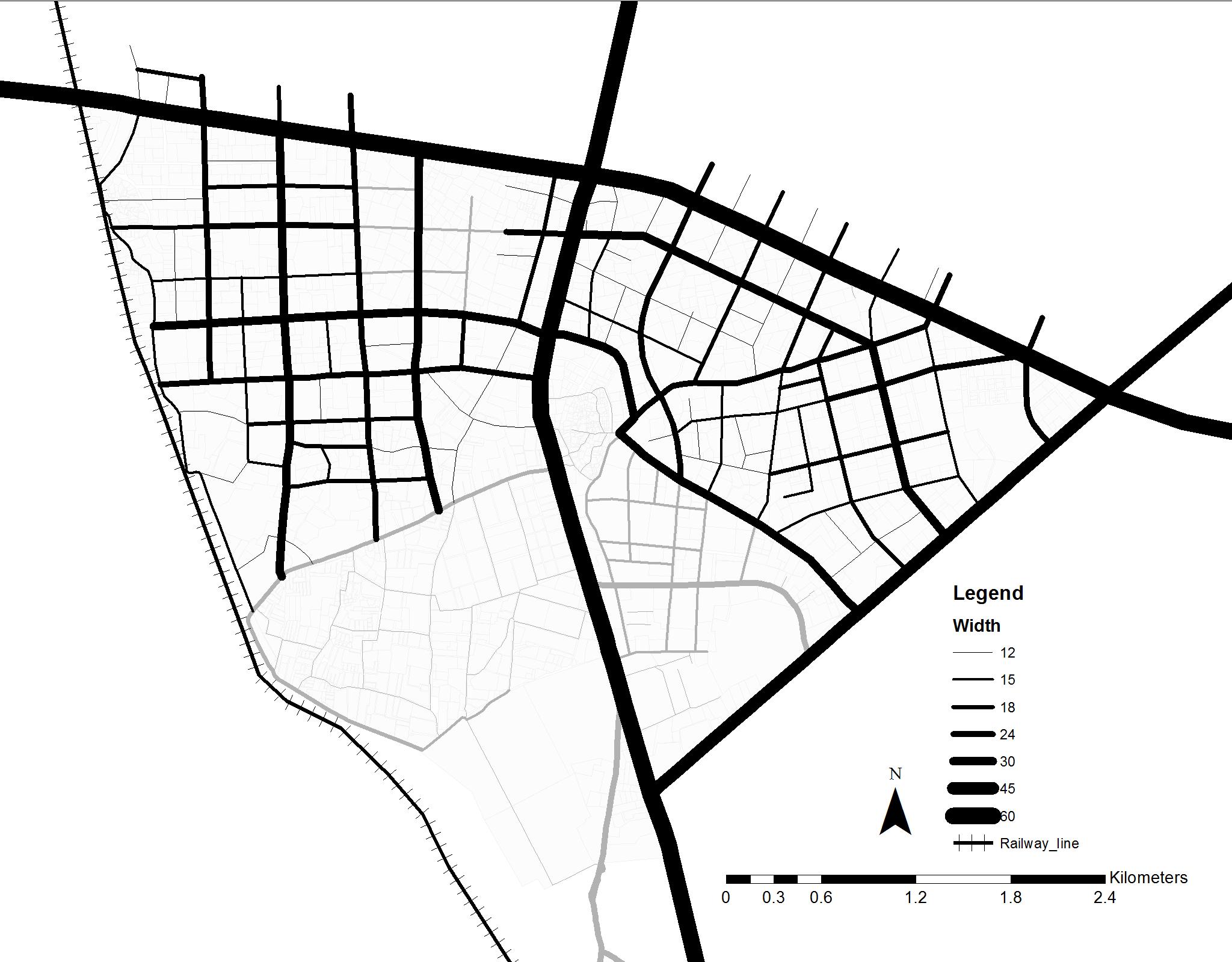
While there are TP schemes to the left of SH 41 but face issues like incomplete streets and no distinct hierarchy, there is a TP scheme to the right of SH 41 that has not been implemented altogether. There are TP schemes present in the area; however, it could be improved. Figure number 9.3 illustrates the
expanding into farmlands 29% of land is vacant and available for growth. 05% of buildings constructed in the past 10 years. street network as proposed through TP schemes. There is incomplete street network towards the west of SH 41. There is a scope to look at all the TP schemes comprehensively to redefine the hierarchy of the system. Defining a more compact and dense street grid will enhance walkability in Chandkheda.
15.2% area under streets, of which
03.8% under Arterial roads
05.9% under sub-Arterial roads
03.4% under collector roads
02.1% under local roads
28 29
Figure 16: Existing street network proposed in TP schemes
Figure 15: Development
STRATEGIES
Concerns with land allocation in TP schemes
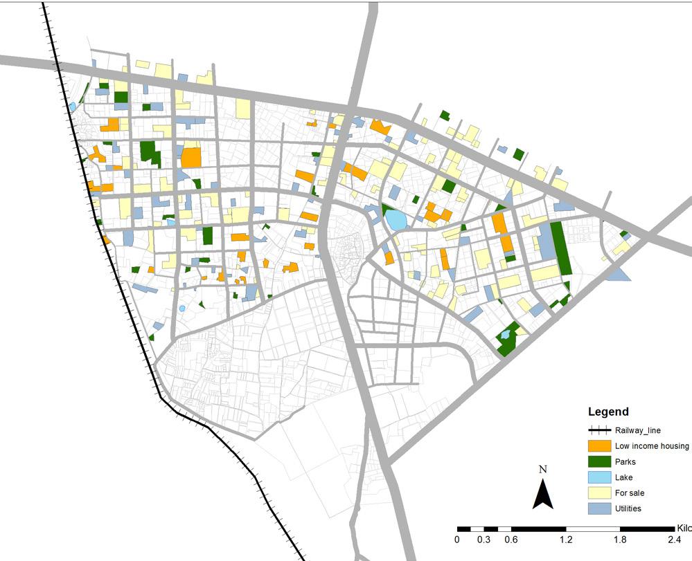
In addition to the street network, the TP scheme mechanism also allows for taking plots for public amenities and infrastructure. The TP schemes look at providing amenities like plots for parking, parks and gardens, schools, hospitals and low income housing. In the current TP scheme, 31.5% land has been taken to provide for such public amenities.
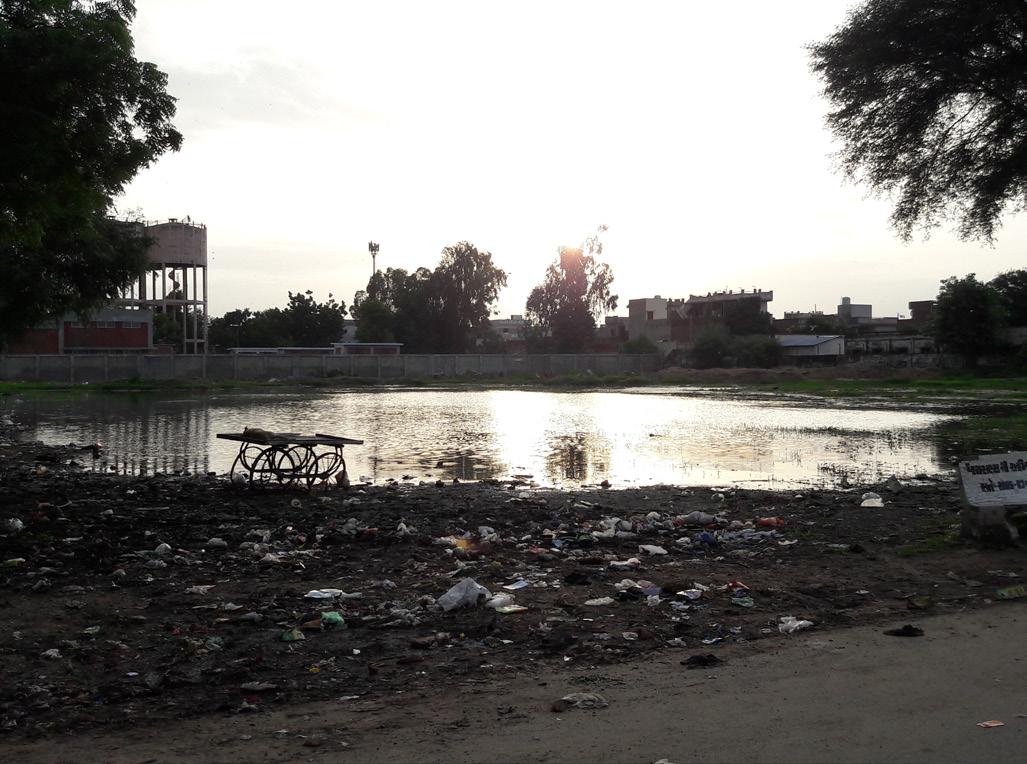
If we look at the six TP schemes comprehensively, there is a scope for improvement in how the land is allocated. For example: Out of the 31.5%, only about 2% of the total area of TP schemes falls under parks and gardens. SH 41 being a TOD zone, it should ideally discourage the use of private parking and have excellent walkability. However, there are parking plots proposed along the TOD which discourages the use of public transport and walkability. EWS housing plots have been proposed far away from the TOD. This is an issue because the lower income populations cannot afford private vehicles and depend on public transport for their travel needs. Since the TP scheme is not yet implemented, there is an opportunity to look at providing low income housing closer to the TOD. Certain plots near the natural lakes and ponds have been demarcated as for sale and utility plots. This hampers the natural topography since water bodies are areas of natural depression and constructing around such natural water bodies is not desirable.
31.5% area under public utilities, of which
15.2% under roads
02.6% under parks
03.6% under utilities
07.7% under for sale plots
02.4% under for low income housing
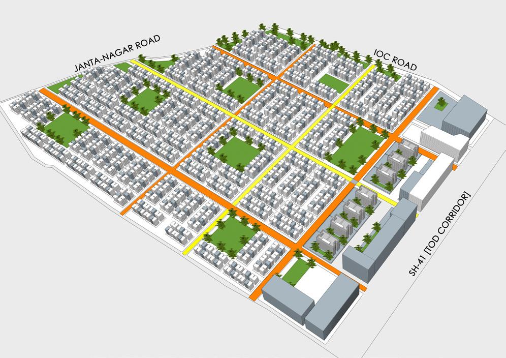
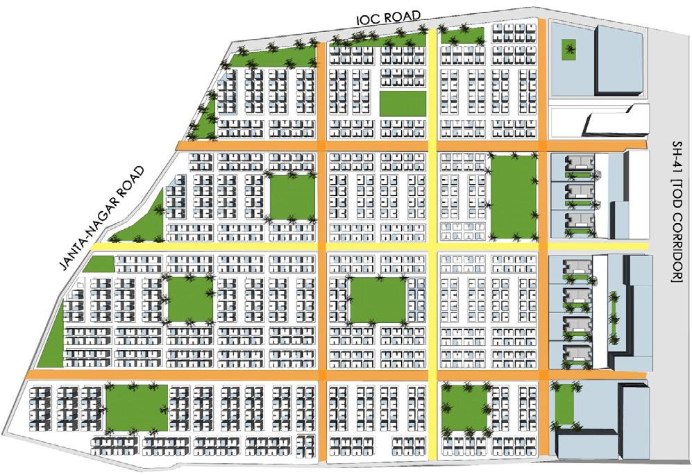
To address these challenges, our key idea is to facilitate organized growth in the fringe area through the TP scheme mechanism. Since the six TP schemes have been proposed, the proposal with look at reallocating land under TP schemes as well as completing the street grid network which is absent or not implemented. There are four distinct strategies to implement this vision.
1. Evaluate And Upgrade Street Network In TP Schemes And Redefine Street Hierarchy And Block Sizes
Having examined the current street network and proposed network in the TP schemes, the proposal will rationalize the street network to minimize block sizes as well as connect areas which are not yet connected and lack a systematic grid network.
2. Create An Open Space Network By Capitalising Natural Assets
The per capita green space in Chandkheda is only 3.2 sq.m. As per WHO standards, land under open spaces should be 9 sq.m. per capita. Thus, Chandkheda lacks green spaces. This is also provided in a fragmented manner. This is an opportunity to create consolidated usable green spaces which will be done through TP schemes. A green space network will be developed through linking all the proposed green spaces.
3. Support Low Income Housing By Linking Them To The Transit Corridor
Since SH 41 is a TOD corridor, it provides an opportunity to provide low income housing closer to the TOD corridor. Since low income populations are primarily dependent on public transport for their travel needs. Through the land allocation in TP schemes, some of the land allotted to low income housing will be relocated closer to the TOD and accessible to public transit.
4. Carve Out Land For Financing Public Infrastructure Projects
In order to fund the projects under the TP scheme, the government authorities needs resources. Thus, this strategy would allow for reserving some land as ‘for sale’. These for sale plots would be sold for residential or commercial development to generate revenue from these plots.
30 31
Figure 17: Existing land allocation under TP schemes
IMPLEMENTING THE PLAN
Project I: Evaluate And Upgrade Street Network In Tp Schemes And Redefine Street Hierarchy And Block Sizes
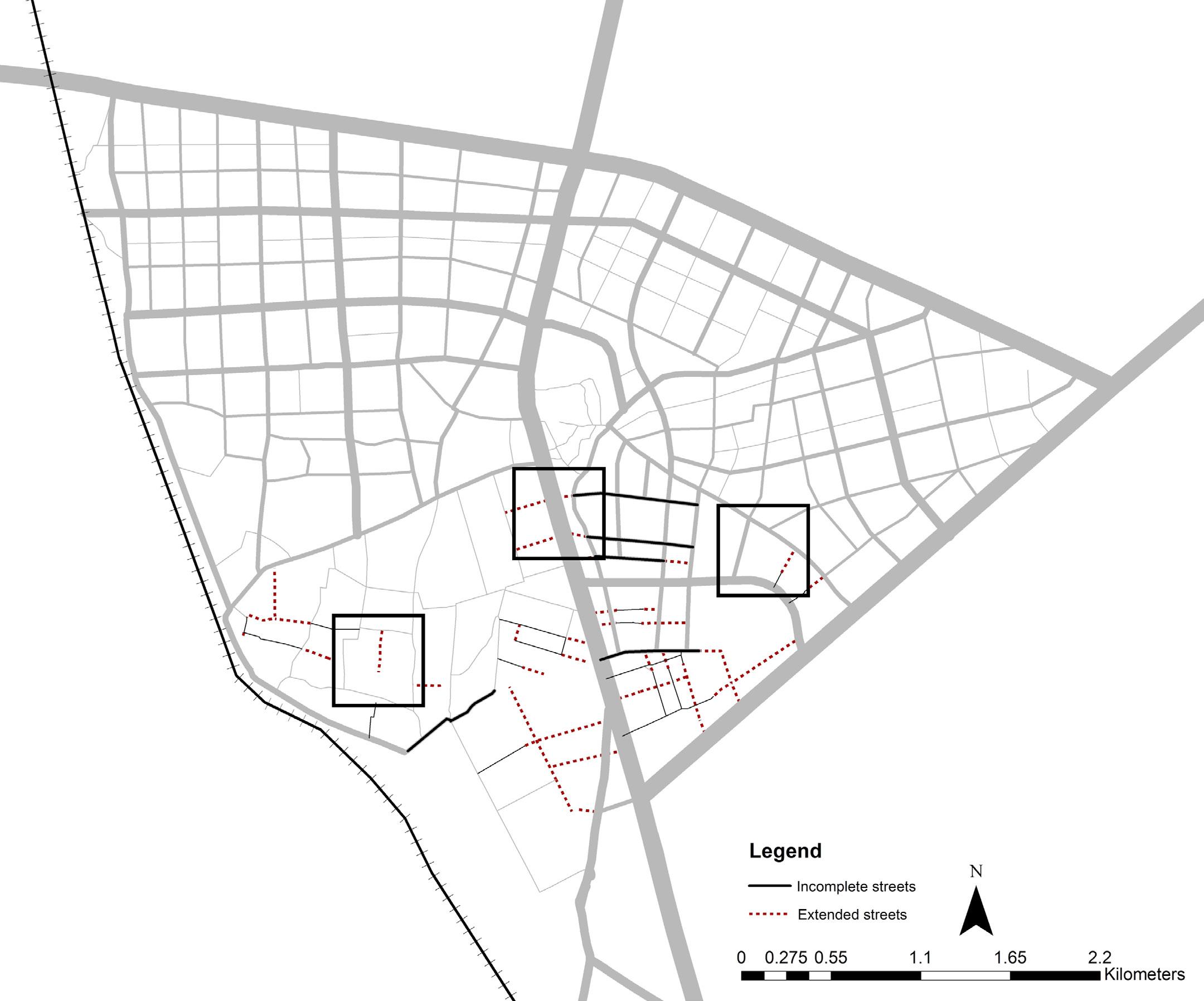
Completing Incomplete Streets
This involves planning an integrated street network by extending all incomplete streets proposed through the TP schemes. Planning a comprehensive street network by looking at all six TP schemes together will strengthen the street network and enhance mobility and accessibility in Chandkheda.
Redefining Street Hierarchy
The existing street network is examined and potential streets are identified. Streets that would in future emerge as sub-arterials have been identified and a revised street network is proposed with changed street hierarchies.
Reducing Large Block Sizes
In certain areas where the block sizes are too large, new streets have been carved out and older streets have been extended to reduce large block sizes and facilitate a walkable neighbourhood.
TP schemes
20.2% area under streets, of which
03.8% under Arterial roads
05.7% under sub-Arterial roads
07.6% under collector roads
03.1% under local roads
32 33
Figure 19: Proposed street network under TP schemes
Figure 18: Existing street network as on ground
Figure 20: Proposed street network by modifying the
Project II: Create An Open Space Network By Capitalising Natural Assets
Create A Green Space Network
Allocate Consolidated Land Under Parks
At present only about 2% land is under parks and gardens. This accounts to only 3.2 sq.m. of green space per capita as opposed to 9 sq.m. as per WHO standards. This signifies that there is a lack of public open spaces in Chandkheda. Consolidating green open spaces would lead to more usable parks rather than scattered small minute parks.
Allocating Land Around Natural Water Bodies As Green Areas As Opposed To Built Up Proposed In The Tp
Allocating areas surrounding the natural lakes and ponds as parks would further enhance the quality of the green spaces in the area with also respecting the topography of the region. Capitalising on the natural topography of the region, the natural catchments are areas of depression and should be paid attention to while allocating land for green spaces.
Linking the parks and gardens in the area through creating a green space network will further enhance liveability in Chandkheda. Since the TOD corridor aims at promoting walkability, developing that as one of the green streets will further improve walkability in the region. Similarly, other arterial streets such as SH71, SP ring road, IOC road and New CG road will be developed as green streets to promote walkability in Chandkheda.
5.0%
6
34 35
Figure 21: Proposed parks and green space network in TP schemes
area under parks
sq.m. per capita under parks and gardens
Project III: Support Low Income Housing
By
Linking Them To The Transit Corridor
Relocating Low Income Housing Closer To The TOD Corridor
SH 41 being a transit corridor, relocating low income housing closer to it would mean that there are more number of people using the transit facility as these are the people who do not own a private vehicle. Since low income housing residents are those who cannot afford to travel by private vehicles, they are most dependent on public transport for their travel needs. Strategically locating these near the transit corridor would mean that a greater number of people would now use transit due to close proximity to the transit corridor.
Replacing Parking Plots Proposed By Amc By Low Income Housing Near The TOD
Since parking should be discouraged in the TOD corridor, the parking plots marked by AMC along SH 41 have been replaced by low income housing. This would discourage the use of private vehicles and encourage usage of public transit through walkability. Figure 22: Proposed low income housing closer to the TOD
Project IV: Carve Out Land For Financing
Public Infrastructure Projects
3.5% under for low income housing
Locating ‘For Sale’ Plots Near The Major Streets Owing To The High Land Prices
Public amenities and infrastructure provided through TP scheme mechanism require resources. TP scheme is financed through sale of plots demarcated as for sale residential and for sale commercial plots. Thus, leveraging certain plots and marking these lands as ‘for sale’ help in generating revenue which is used in carrying out the public projects. Plots for sale are typically located closer to the major transport corridors as such plots have a higher land price as compared to the other plots inside the area.
TheJantriratesforresidentialplotsinChanadkhedais8750Rs. per sq.m. and that for commercial plots is 25000 Rs. per sq.m. Thus, when we include all the land for sale in the TP scheme, the total costing comes to around 2000 crore. This revenue from the sale of plots will be used to finance the public infrastructure projects like low income housing.
Total area under for sale residential plots: 18,79,325 sq.m.
Total area under for sale commercial plots: 4,99,111 sq.m.
Total cost of for sale residential plots= 18,79,325*8750 =16444093750 Rs.
Total cost of for sale commercial plots=4,99,111*25000 =7486665000 Rs.
Total revenue generated from sale of residential and commercial plots: 23930758750 Rs.
36 37
38 39
schemes 40.0% area under public utilities, of which 20.2% under roads 05.0% under parks 03.6% under utilities 07.7% under for sale plots 03.5% under for low income housing
Figure 23: Proposed land allocation under TP
Figure 24: Visualising new streets and green spaces through TP scheme
02 . ADDRESSING SPATIAL DISCONNECT
Improving existing street network to strengthen the internal street connectivity
41
OVERVIEW
Street connectivity
The term “street connectivity” suggests a system of streets with multiple routes and connections serving the same origins and destinations. A well-designed, highlyconnected network helps reduce the volume of traffic on major streets, improves pedestrian accessibility and ultimately improves livability in communities by providing parallel routes and alternative route choices. Local street connectivity provides for both intraregional and inter-neighborhood connections to knit developments together, rather than forming barriers between them.
Characteristics
Street network is considered to be one of the keys to the development of a region. The huge developmental cost of the road network demands effective utilization, which can be attained only when there are proper connectivity and orientation. Though in most Indian cities streets have developed organically over a period of years. Hence the challenges in the area of existing development are to rationalize this organic network to design a well-connected street network.
Content of street connectivity
The study of street connectivity consist the aspects of the percentage of area under a street, block sizes and the number of intersections.According to UTTIPEC TOD report 2012, maximum walking distance is

ISSUES, OPPORTUNITIES AND CHALLENGES
800m (10 minute walk). Maximum walkable block size is 800*450 meters i.e. 2500 meters. The street configuration within each parcel must contribute to the street system of the neighborhood. Street connectivity is closely linked with attractive features for walking that increase ‘place value’ and ‘Functional value’ which project the decision making for route choice
Street network in Chandkheda
In the areas of Chandkheda, strategies would differ to carve out or to extend the streets. In area like Gujrat Housing Board, the street network will gradually emerge over time as redevelopment happens. Regions like ONGC (oil and natural gas Corporation limited), VJEC (Vishwakarma Government Engineering College) would have streets carved out from public land as it has a potential as a resource. Currently, predominant streets in Chandkheda would emerge by expanding its hierarchy considering setbacks or right of way. All above ways to carve out streets would help in connectivity pattern of road network.
Intra-region connectivity in Chandkheda
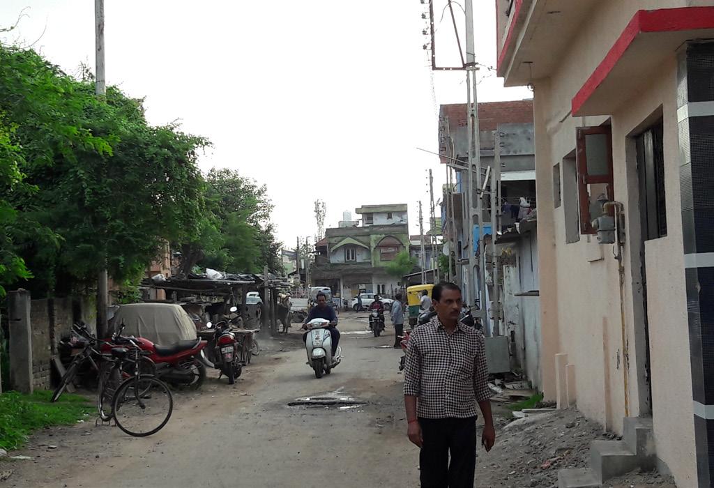
Chandkheda offers a relatively good regional connectivity. Though internal street connectivity still spars.The denser street network is present in the south-west region with minimal hierarchy. Streets have emerged organically according to built fabric along new CG road. In the southern regio has presence of larger plots with very few streets.
Incomplete streets and abrupt dead-ends
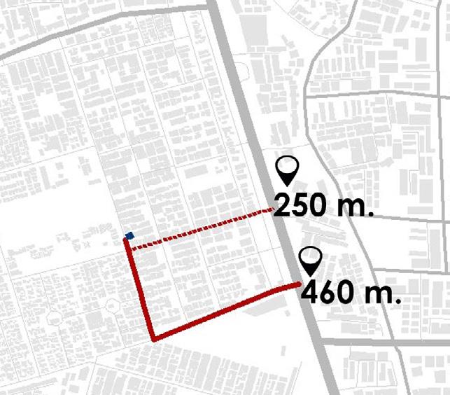
As the presence of organic built fabric in the internal region of Chandkheda, streets are emerging in an organic pattern. Organic growth of the streets according to the built fabric in south-western area and no continuous development in eastern region are causing incomplete streets and abrupt dead ends, which is leading to lack of connectivity.Very few streets are directly connected to TOD spine hence very limited access is formed from internal region to TOD corridor.
Internal street connectivity and accessibility
Absent streets also cause large block sizes, leading to less accessibility in the ward. It takes longer travel time and distance to reach the destination for a person/good. Giving examples of GHB, which is in the vicinity of 200 m. long from TOD corridor, still, the user has to travel to around 400 m. to reach the TOD spine.
Figure 25 : Existing incomplete streets and abrupt dead-ends
3% streets has potential to extend and complete the street network.
Travel distance from GHB to TOD is 460 m.
42 43
STRATEGIES
Minimal street hierarchy
Coming to existing streets, few streets in the internal region has potential to emerge and expand its hierarchy. Such predominant streets are present majorly in Gujarat housing board and along New CG road as existing commercial development is present along the streets. In the eastern region, few streets are directly connected to major arterial SH71 and TOD corridor carrying more vehicular traffic. Hence comparatively more number of users (Pedestrians and vehicular) occupying the streets
Though due to minimal street hierarchy, streets are unable to occupy more users and causing congestion. Hence there is a requirement to rationalize the existing street and expand its hierarchy.
Analyzing the public and private stakeholder’s interest helped in understanding the area more distinctly.
“On IOC road, with commercial establishments in last 10 years, have in the increased in the ownership of private vehicle.Management of existing traffic and providing parking in a common plot should be resolved.”
06 % streets have potential to emerge.
75% commercial development along the predominant streets
To address the spatial disconnect in Chandkheda, rationalizing the existing street network is necessary. Which further will lead to strong internal connectivity. Hence the key-idea to transform the area is, “Improving existing street network to strengthen the internal street connectivity.”To achieve above vision, strategies are formed on the basis of analysis of existing area and with collected supporting data.
1. Continuing and completing the street network
Continuing the streets, removing dead-ends and with frequent intersections, to form a complete street network, good accessibility and efficient traffic and pedestrian flow.This can be achieved by analysing existing street network to identify incomplete streets, dead-ends to extend them.
2.Prioritizing public land to carve out new streets
3. Redefining hierarchy of predominant streets to support current functionality Expanding hierarchy of currently predominant streets to support the functionality and accommodate a maximum number of users.This requires taking few considerations of including margin lines if any available or considering the right of way if the area falls under re-development.This requires identification of predominant streets according to their functionality and more users occupying the streets.
“The lack of connectivity from internal region and especially to TOZ, causing high traffic congestion during peak-hour at major junctions of TOD.”
Prioritizing public land to carve out public streets as public land has higher potential as a resource. Also, availability of vacant plots in public land is beneficial. Survey of private and public land ownership would support to prioritize land that falls under public domain. Though learning related regulations and schemes is necessary.
44 45
- Kamlesh Shah,Shop owner, along IOC road
-Shyamal bhai Patel ,shop owner
Figure 27: Predominant street in GHB
Figure 26: Existing predominant streets
IMPLEMENTING THE PLAN
Incorporating strategies to achieve improved network, required to generate supporting information as way forward. Supporting data was gathered through various onsite surveys and by taking interviews of important stake holders in Chandkheda and then the ways were carried out to incorporate strategies.
Project I: Extend the streets to form a complete network in order to improve street connectivity, accessibility and to reduce block sizes.
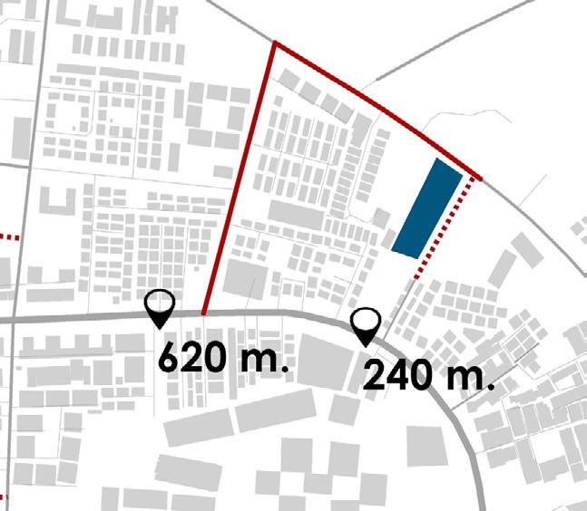
Initially to identify incomplete streets, analysis of existing street network has been done, with supporting data of spatial survey of Street network. Identification and reconnection of missing links, by continuing the streets, removing dead-ends and with frequent intersections, to form a complete street network, which would provide good connectivity and efficient traffic and pedestrian flow
Extended streeets would also reduce the block sizes which will reduce the travelling distance and time of user. It offers people alternative routes to reach at the destination. Mainly it will improve the accessibility to transit corridors within different areas of Chandkheda.
46 47
Figure 28: Extended streets
Travel distance reduced to reach nearest transit corridor from CG road is 240 m.
Travel distance reduced from GHB to TOD to 240 m.
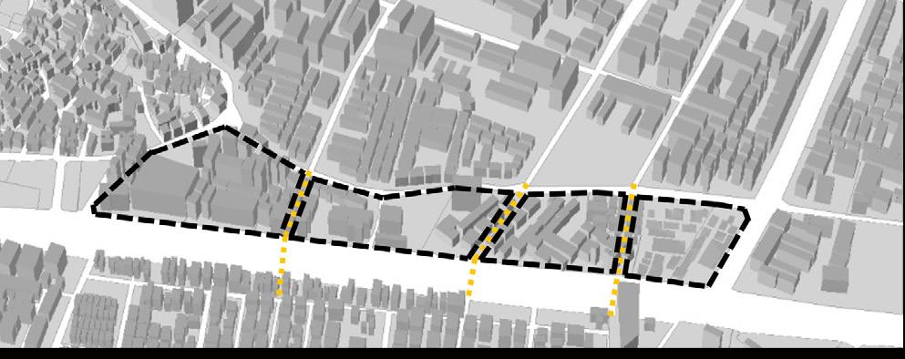
Project II: Proposing new streets as area goes into Redevelopment
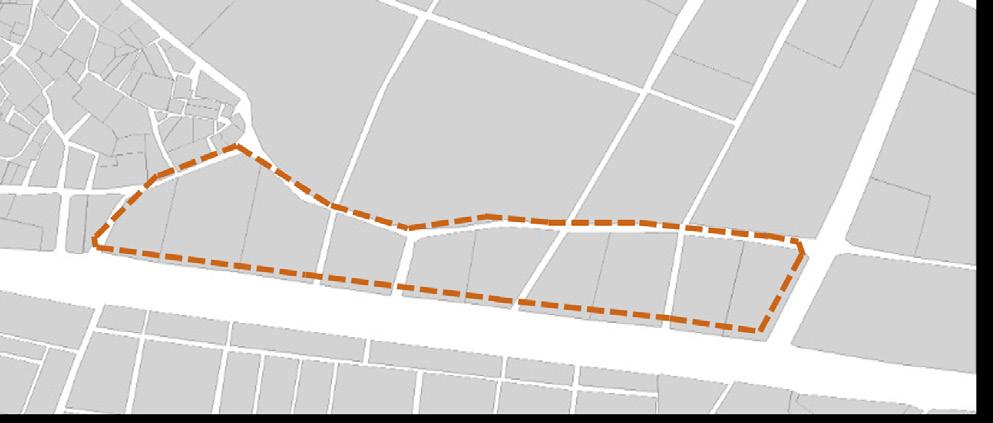
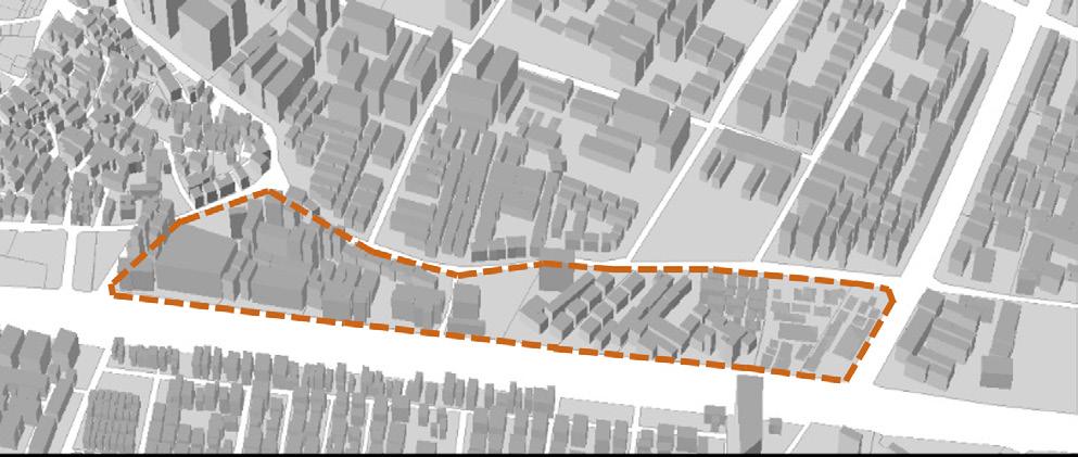
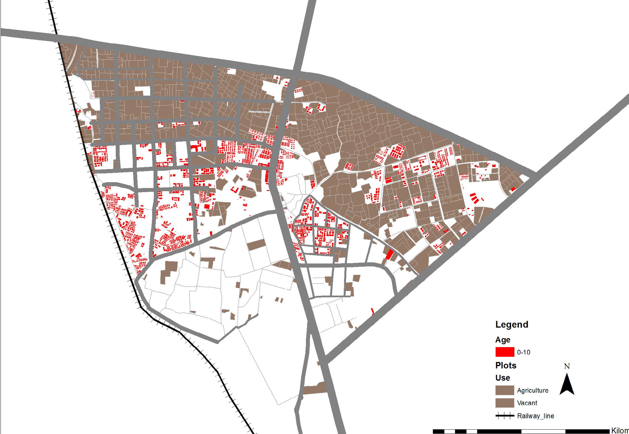
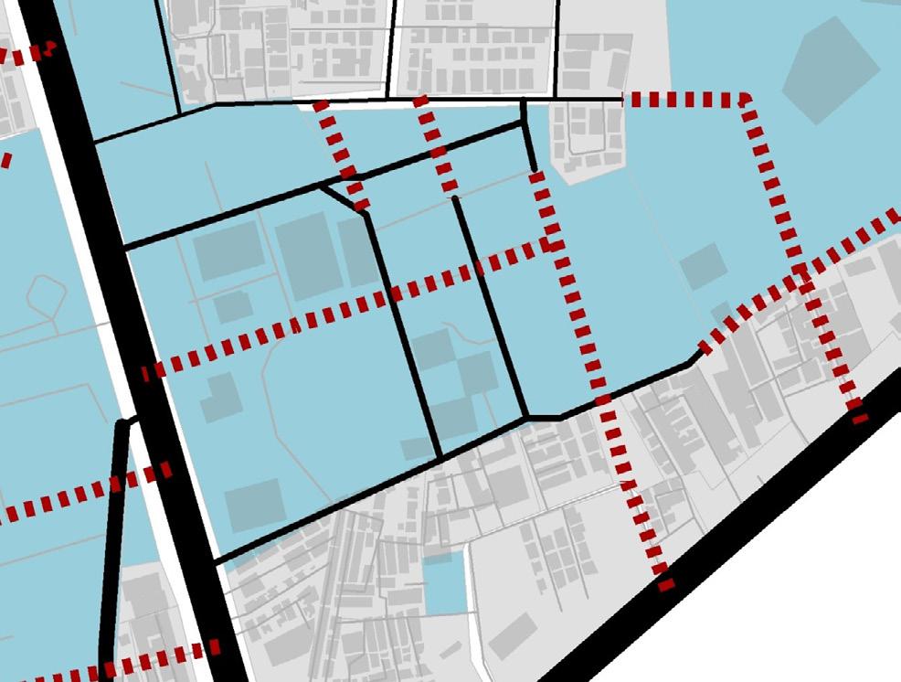
Redevelopment is likely to happen in the areas which has old built fabric. Land falling under redevelopment provides an opportunity to carve out or extend new streets. The building age map is highlighting the built fabric which is 30-50 or more than 50 years old. Hence in coming 2030 years, the land provides opportunity to carve out new streets as those areas will go under redevelopment. As an example to show the procedure, a chunk of land has taken which is along TOZ road and has existing built fabric of 30-50 years old. The area today consists a particular development. New streets and blocks are proposed for the area which would be appropriated when the plot is redeveloped. With the future plot configuration, proposed streets would be achieved with proposed blocks.
48 49
Figure 29: Proposed extended streets
Existing development along TOZ
New Streets to be appropriated when plot is redevoped
Future plot configuration
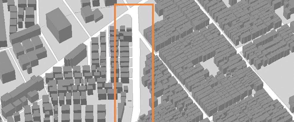
Project III: Prioritizing public land to carve out public streets
Prioritization public land to carve out public streets as public land has higher potential as a resource. Streets in GHB, ONJC area have been carved out from Public land and streets in North periphery and near new cg road area have been carved out from Private land. Also availability of vacant plots in public land is beneficial. In given example, the land falls under public domain and belongs to ONGC (Oil and Natural Gas Corporation Limited).Also, the land has availability of vacant plot is beneficial, as there is no built fabric present. Hence the land provides higher potential to carve out new streets. Land falling under public domain and belong to VGEC (Vishawkarma Government Engineering Collage)
50 51
Figure 30: Public and private land ownership
Project IV: REDEFINING HIERARCHY OF PREDOMINANT STREETS TO SUPPORT CURRENT FUNCTIONALITY
The present predominate streets that has potential to emerge through their functions and comparatively more users, the way forward is to expand the minimal street hierarchy. Expanding hierarchy of currently predominant streets to support the functionality and accommodate maximum number of users.
Considerations:
1. Including margin lines if any available
2.considering right of way in case of area falls under redevelopment.
Expanding in Set-back
In given example, a predominant street present in GHB and has setback of 3.00 m along it. Hence including margin lines, the street has been expanded from 12 m. to 15 m. and the hierarchy of the street is redefined.
52 53
Figure 31: Expanded heirarchy of predominent streets
Existing predominant street
3.00 M. set-back along the street
Expanded street (Setback to be appropriated when plot is redeveloped)
As per the analysis, identified issues of incomplete Astreets, large block sizes and minimal street hierarchy has been resolved by adapting strategies of continuing streets and expanding hierarchy of streets.
27.0% area under streets, of which
3.1% under Arterial roads
6.2% under Sub-Arterial roads
7.4% under Collector streets
9.5% under Local streets
54 55
Figure 32: Proposed street network
Figure 33: Visualising new streets and green spaces through TP scheme
57 03 . RECLAMING STREETS FOR THE
Improve pedestrian infrastructure across Chandkheda with redesign the pedestrian infrastructure in the area.
PEOPLE
OVERVIEW
“If we can develop and design streets so that they are wonderful fulfilling places to be community- building places, attractive public places for all people of cities and neighborhood, then we will have successfully designed about one third of the city directly and will have had an immense impact on the rest”. - ‘Great streets’ Allan Jacob
Streets shape the type of the city and how we travel through it. Streets accommodate buildings, people, goods, services, vehicles, vegetation, furniture, lighting but also as front yards for parks, playground and public spaces. Streets are the most utilized and most noticeable open resources a city has. They must be safe, sustainable, resilient. To assemble great urban areas and towns, first form great streets.
Indian streets battle to accommodate the contending necessities of mobility and live ability. as percentage of private vehicle is growing day by day, it is very difficult to hold sufficient space for other social activities in our streets. Over time, streets have come to function less as social gathering spaces and market areas, and more as conduits for an ever-increasing volume of traffic.
In an urban fringe context, streets must meet the needs of people, vehicles, transit, all in a constrained space. The best street design includes all street design elements such as footpaths, cycle lanes, landscape, vending, service lanes, carriage lanes, transit lanes, parking etc.
59
ISSUES, OPPORTUNITIES AND CHALLENGES
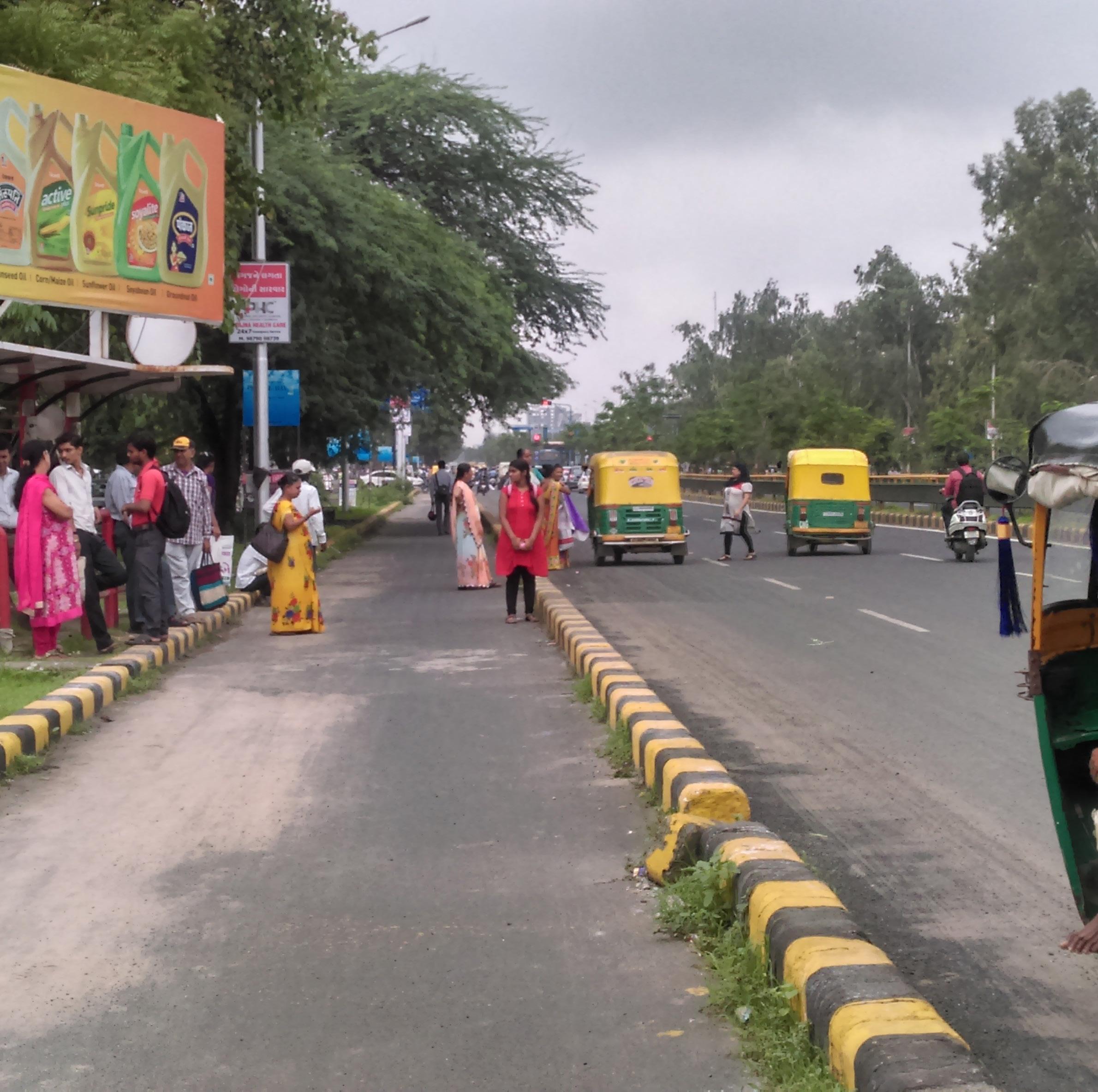
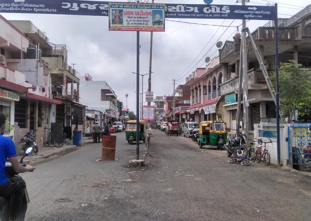
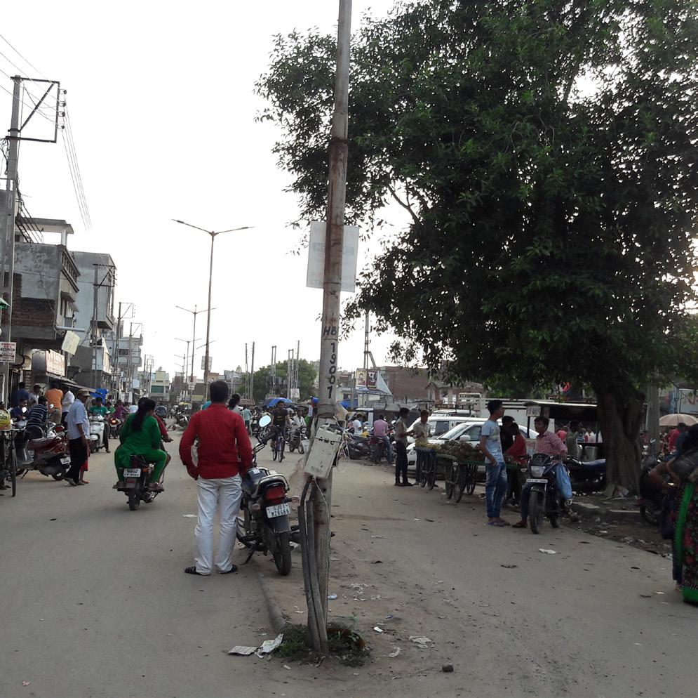
Chandkheda as an urban fringe is facing a common issue which isn’t the lack of “connections”, the quantity and the variety of roads traversing the area. The problem, rather, is their quality, especially the poor pedestrian experience they offer due to a systematic deficit and neglect of spatial attributes and features of the built environment which encourage walking.
Chandkheda is also facing a major issue which is lack of infrastructure which also leads to several other challenges in that area. SH 41(60 m), a transit oriented corridor act as a major spine in chandkheda which connects chandkheda to Gandhinagar as well as to Ahmedabad. Also, due to lack of connectivity Sh 41 possess maximum traffic flow which needs better pedestrian safety. pedestrian safety. Chandkheda streets doesn’t support pedestrian infrastructure. In SH 41, the priority is given to motorized
vehicles. Later whatever space is left over after creating carriagewayisdesignedaspedestrianspace. Theplacement of utility boxes, trees, light poles on the footpath leaves no clear space for pedestrian movements. the maximum width of footpath given at sh1 is about 2- 3 meters which is further used by vending and haphazard parking. In this case, footpaths are difficult to use it ends frequently at service lanes or carriage lanes. Poorly designed footpaths remain underutilized and are easily encroached by parking vehicles and vending. In the absence of an adequately sized and usable footpath, the only space left for pedestrian is the carriageway.
61
ISSUES Improper pedestrian infrastructure Haphazard on- street parking No specific space for vending
As per Vehicular and pedestrian flow analysis
Footpaths or sidewalks are the portion of streets only reserved for pedestrians. at SH 41 minimum width of footpaths is even somewhere less than 2 meters which is not convenient for pedestrians to walk freely. Even the height of the footpath is 250 mm which is again not convenient for pedestrians to change the level while
crossing.
Existing street design fails to address basic pedestrian infrastructure to support pedestrian footfall.
Pedestriantreatedasnuisance and undesirablesometimes.
One dot represents 5 vehicle
Sh 41, IOC Road and new Cg road is majorly facing this issue because of commercial activities. There is no such space designed for parking over street at these roads. Where footpaths are not provided, haphazard parking are creating difficult conditions for pedestrians, who are forced to weave their way through the parking area or walk on the righthand edge of the parked vehicles, in moving traffic.
62 63 New CG road
Two- wheeler 65% Car 20% Auto 15%
Figure 34: Visualising new streets and green spaces through TP scheme
Figure 35: Visualising new streets and green spaces through TP scheme
One dot represents one vendor
Existing street design fails to address street vending. As a result, vendors end up using spaces intended for others such as footpaths or the carriageway.
Existing street design fails to address street vending. As a result, vendors end up using spaces intended for others such as footpaths or the carriageway
Number of vendors
35 vendors on SH 41
22 vendors on New CG road
13 vendors on IOC road
64 65
Figure 35:Land price map showing prices of land
New CG road
Figure 36:Land price map showing prices of land
STRATEGIES
1. Redesigning major roads (SH41, IOC road, New CG road) to facilitate greater pedestrian experience:
2. This can achieve by creating streets in chandkheda which prioritize streets for the people and not for vehicles, thereby reinstating the position of streets of chandkheda as dominant and most vibrant urban public realm.
3. To integrate functional requirements of all road users and stallholders in the street design as per priority, suitability and need of each road user, ensuring that there is equitable allocation of available road space across all stakeholders.
4. To design and develop streets for safety of all users.
IMPLEMENTING THE PLAN
METHODOLOGY
A spatial survey of existing street conditions was taken to study the scale of the issues like Haphazard parking, vendors over streets, poor pedestrian infrastructure etc. after interaction with some stallholders like pedestrians, commercial shops owners who has shop along IOC, school children, BRTS users, to learn the challenges they face each day.
Later the traffic count survey is also taken to understand ratio of street type and its occupying users of each road of chandkheda. Which help to design the streets as per the traffic concentration at various areas of a road. Another survey was taken to calculate the maximum concentration of haphazard parking over streets and also another survey is for position of vendors on streets. These surveys are to understand the uses of the different roads as per the needs.
After analyzing and collecting supporting data, we started incorporating strategies. With the help of maps, images and analysis, the attempt has been taken to redesign these streets as per there uses
66 67
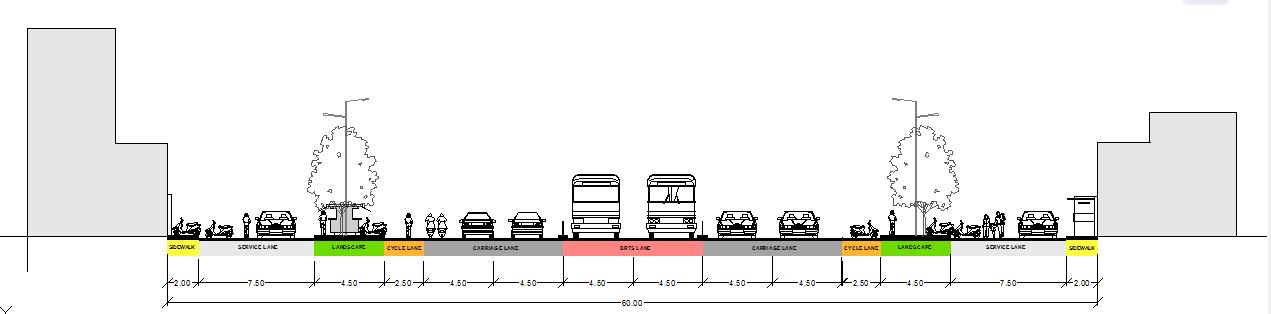
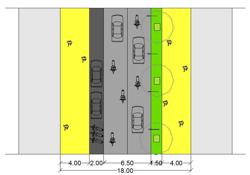
REDESIGNING THE MAJOR ROADS
EXISTING STREET
The roads is designed considering the existing traffic pattern and the functions of the streets that evolved over the current use of the streets.
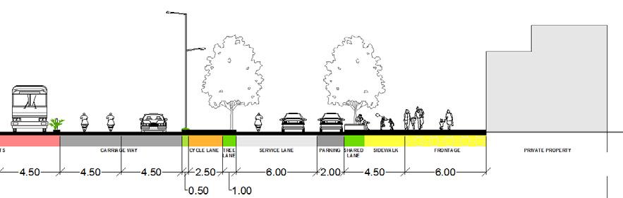
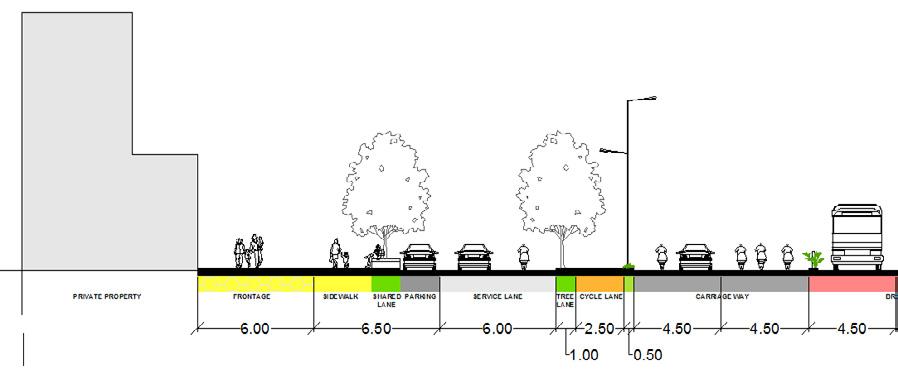
Every road in chandkheda has different functions, different land use and thus different design requirements.
68 69
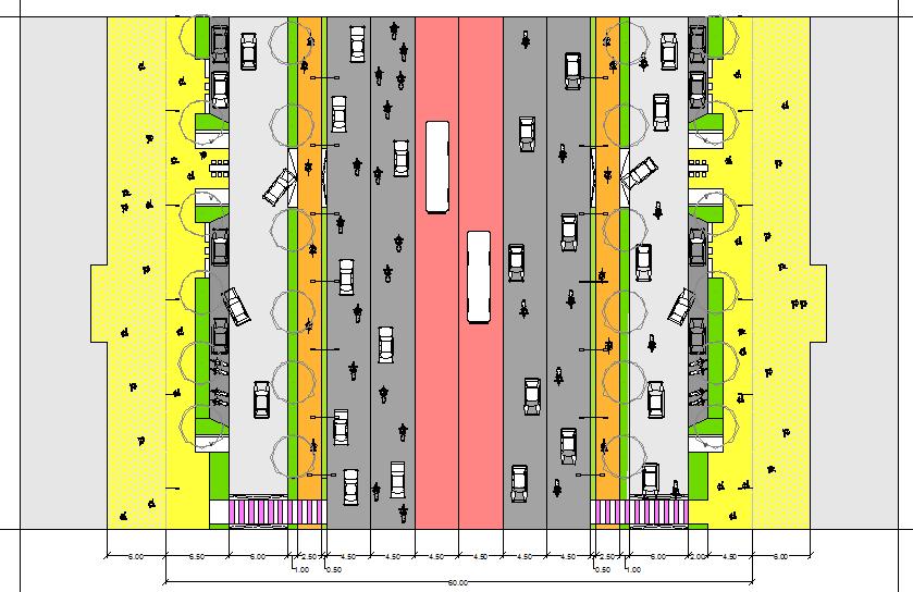
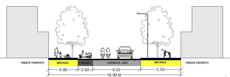
SIDEWALK FRONTAGE LANDSCAPING VENDING PARKING SERVICE LANE CYCLE LANE MEDIAN CARRIAGEWAY BRTS PEDESTRIAN CROSSING PLAN SECTION
Existing
Street Design for SH41
Figure 35: Design of SH-41
REDESIGNING THE MAJOR ROADS
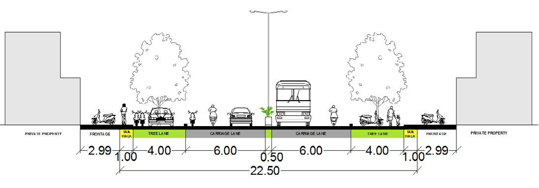
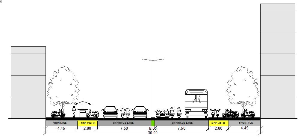
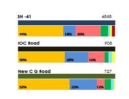
70 71 ANALYSIS DESIGNED USE 44% For Pedestrian 56% For carriageway 0% For parking CURRENT USE 24% For Pedestrian 66% For carriageway 10% For parking Existing use of transit-oriented corridor- SH41 ANALYSIS DESIGNED USE 32% For Pedestrian 67% For carriageway 0% For parking CURRENT USE 5% For Pedestrian 48% For carriageway 57% For parking Existing use of IOC Road Existing use of New C G Road ANALYSIS DESIGNED USE 15% For Pedestrian 65% For carriageway 0% For parking CURRENT USE 3% For Pedestrian 47% For carriageway 50% For parking
SIDEWALK PARKING LANDSCAPE CARRIAGEWAY
Figure 36: Section of existing road
Figure 37: Section of proposed road
04. REDEVELOPMENT OF OLD GHB INTO NEWER MIXED-USED HOUSING COMMUNITY
Supporting mix-use mix-income development in Gujarat Housing Board housing
73
OVERVIEW
Context of GHB public housing
Gujarat Housing Board came into existence on 1st May 1960 as a result of bifurcation of Bombay State and Bombay Housing Board and the Gujarat housing board act was formed on 1961
Public housing concept in India
Since independence government agencies have been constructing affordable public housing, as a tool to support people having low income. Many of this public housing colony has been constructed 40 years ago using old tools and techniques. The structure has gone through deterioration and this had caused poor living condition which are not appropriated for habitation Several of this where constructed on low-housing and low density. Over the years, people expanded and new houses where constructed and people started residing this had cause illegal construction inside the housing colony. Most of the roads and green spaces where encroached by illegal tenants. This caused of unorganized bacterial growth inside the colony. This caused the government agencies to think about redevelopment of housing colony to accommodate more people with proper infrastructure facilities.
ISSUES,OPPORTUNITIES AND CHALLENGES
Redevelopment
Redevelopment is one of the most effective ways to breathe new life into deteriorated structures plagued by social, physical, environmental conditions. Several of Housing committees are considering redevelopment of the structures at higher density to accommodate more people having more unit size with better living conditions. The redevelopment process also helps to generates revenue by selling the extra units and this revenue is
Context of GHB
Gujarat housing board is located along the SH-41 which is a designated Transit corridor. This public housing in Chandkheda was constructed around 30 years ago to accommodate population of around 10,000 over an area of 0.46 km2 with 24.31% area under streets and 3.71 % area under parks and gardens
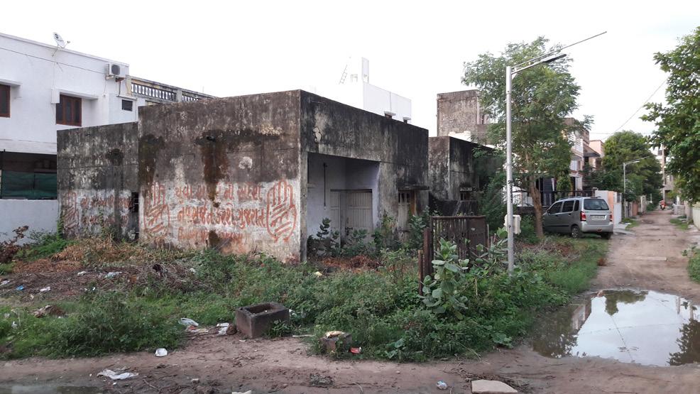
Old and dilapidated structures with lack of physical infrastructure facilities
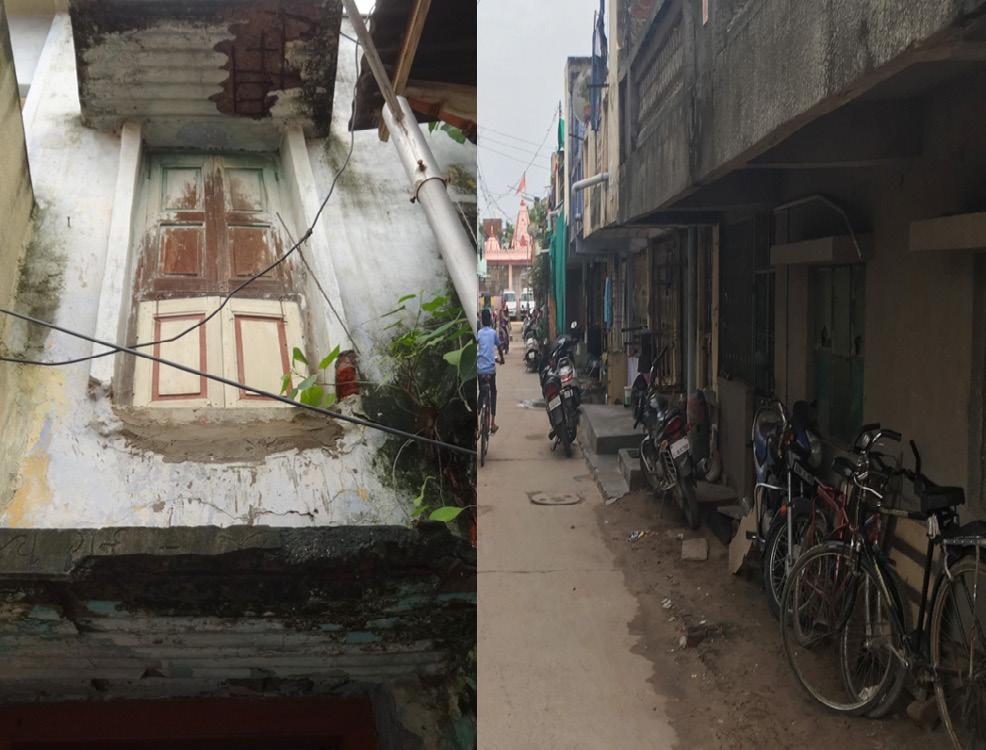
The present scenario of public housing has very poor condition of houses as these houses where constructed using old techniques and the other reason is houses where constructed around 30 years ago and many of the houses in GHB are not fit for habitation
74 75
Fig 38: Location of GHB in Chandkheda
Fig 39: Gujarat housing board public housing
Fig 40: Gujarat housing board public housing
Rampant illegal construction within Public housing colony
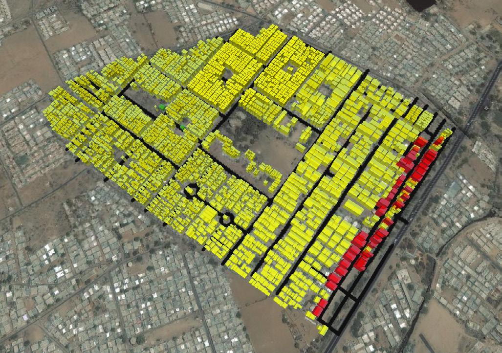
The major issue faced in Gujarat housing board is the illegal construction caused by the residents itself and some by the Illegally migrated residents from slums, During the construction of Public Housing Policy, it was meant to provide habitation for 10,000 people only but as time passed people started migrating illegally from slums and residing in GHB. This cause illegal settlements in the Gujarat housing board and tenants start building kuccha house near the houses of people. The space along the roads and green spaces provided within the GHB were utilised by the tenants to construct illegal housing within GHB.
Limited street connectivity and poor road condition
In Gujarat housing board the inner street are not so prominent to handle the population of GHB itself. And even because of informal settlements along the road it has decreased the effectivity of the road. The road condition inside the GHB is also poor. In terms of internal street connectivity, the major roads around GHB like IOC road and Janta-nagar road are also not properly connected. This is an issue to handle because longer distance cause more fuel consumption and increase in trip time.
76 77
Figure 42: Illegal construction in GHB
45.71% buildings are illegal constructed inside the Housing colony
Illegal buildings inside the plot
Fig 41: Dense built fabric due to illegal constructions
Figure 43: Present condition of street network 11.41% area under streets
Figure 44: Poor road condition within GHB
STRATEGIES
Limited green space
Public housing colony has 0.46 km2 area and area allotted for green space is only 3.71% which is not sufficient for the population of 10,000. The green spaces provided in the Gujarat Housing Board are very less and some of the spaces are encroached by the illegal tenants. Green spaces provided inside the GHB are either not properly maintained or are covered by many illegal tenants. The closest park outside GHB is around 2.5 km from GHB. So, it is very important to manage land which is allocated for park and more spaces should be carved from GHB for parks and playgrounds.
3.71% green spaces
To address the issues mentioned above, our key idea is to redevelop public housing into higher density community with newer buildings, more green spaces, better infrastructure facilities and good roads
There are four distinct strategiesto implement this vision
1. Providing housing for current habitation (including illegal tenants)
There are total of 4478 units present in Housing colony of Chandkheda which has total of population around 40,000 from that around 2000 units are illegal constructed. The space occupied by this tenant are encroached on roads and open green area. Redevelopment of housing colony will have more household units having more unit size area which can occupy more people with good infrastructure facilities
3. Improving area under green spaces
Gujarat housing board has 0.46 km2 area and area allotted for green space is only 3.71% which is not prominent for the population of around 20,000 and green spaces provided inside the GHB is either not properly maintained or it is covered by many illegal tenants
2. Improve street connectivity especially linking to TOD
The redevelopment project will have roads which are good in condition and will have better connectivity from IOC road to Janta-nagar road, and even new streets will also get laid in the GHB. New street network laid will have street hierarchy and the amount of green spaces are also constructed by allocating land inside the block
4. Financing redevelopment from selling of units
The redevelopment strategy will have around 7000 residential household units and 180 around commercial+ retail units. The 250-meter land along the SH-41 comes under TOD this makes the Housing colony a very prominent land to promote commercial activities so the idea is to develop commercial unit along TOD and then sell those unit. Revenue generated from that will foster development in constructing of the household units.
78 79
Figure 45: Open space in GHB public housing
Figure 46: Present green spaces in GHB
IMPLEMENTING THE PLAN
Project 1: Providing housing for the residents of GHB (includind illegal )
Present scenario of housing in GHB has very large amount of illegal house constructed along the road, in between the houses and also some number of houses are constructed in the green spaces allocated to them
Total there are around 1324 units’ illegal out of 4478 units which makes 30 % of household are illegal in GHB in the after development there will be houses constructed for people residing illegally with some rent scheme policy so that they can house in which they live and they have to pay rent in form of installments and all the basic infrastructure facilities will be provided to them like water and electricity .
After redevelopment there will be total of around 8944 units for residentials residing inside the Public Housing as well as illegal tenants in GHB
80 81
Figure 47: Visualising GHB public housing colony after redevelopment.
Project 2: Improving street connectivity especially
linking to TOD
2.1 Carving new streets inside the housing colony
The proposed plan of Public housing will have 15 meters and 12-meter streets running horizontally and vertically in the plan which will provide a good connectivity from IOC to Janta-nagar road and Janta-nagar road to SH-41. This direct connectivity will reduce the travel distance by 540 meters from SH-41 to Janta-nagar road.
2.2 Providing direct connectivity to TOD
The proposed plan is having 3 major horizontal street two 15-meter road and single 12-meter road which will provide direct access to the SH-41 which is a TOD corridor, as proposal have commercial buildings along the TOD corridor
2.3 Improving street herirachy
The existing street inside the GHB is for private use only and very less street are meant for public the proposal will have 6 major streets for public use which is following a street hierarchy for better movement of traffic
Project 3: Improving green spaces
Project 4: Financing the project
3.1 Carving new green spaces inside the housing colony
The exisiting condition of green spaces in public housing is very less there is only 3.71%
area under green space
The proposed plan will have 7.40 % area under green spaces which will include parks for both public and private use.
The land along the TOD corridor will be sold to private developers to build high-rise residential and commercial buildings. The revenue generated will foster the development of low rise residential apartments.
The revenue generated from selling the land will generate 200 crore which will foster the development
82 83
Figure 48: Proposed road network plan
Figure 49: Visualizing proposed road network
Figure 50: Proposed green spaces
05. TRANSIT SUPPORTIVE DEVELOPMENT
Support mixed-use, mixed income, high density, transit and pedestrian frienldy development along SH-41
85
OVERVIEW
What is a TOD?
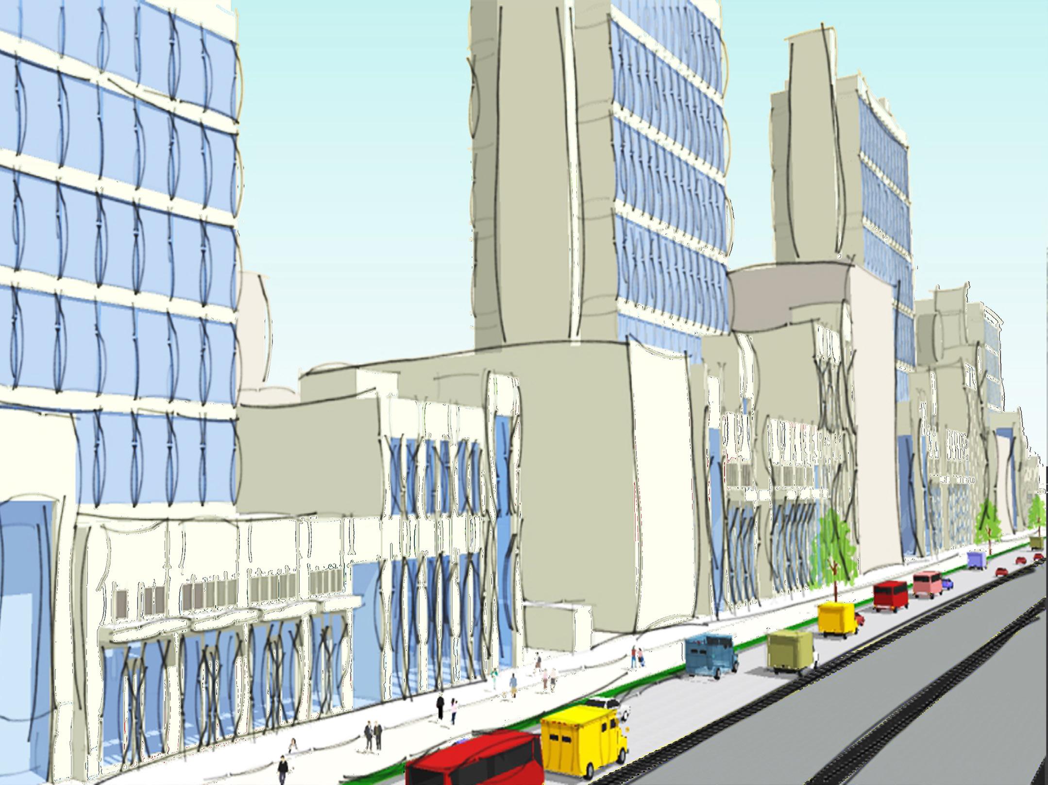
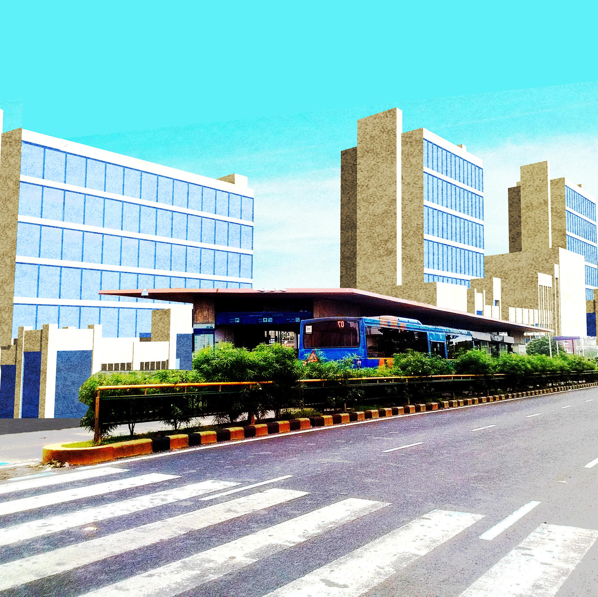
The TOD sums up all the new priorities for contemporary urban development. It reflects a fundamental shift from the old, unsustainable pattern of car oriented urbanism toward a new model where urban forms and land uses are closely integrated with efficient, low-impact, and people oriented urban travel modes: walking and transit. It is critical to encourage the development in the area. It also gets crucial to bring the haphazard growth that occurs due to the existing development norms, to a sustainable development model that complements the desired active public realm of the streets. This sustainable development is another push factors that promotes build-to-line development to maintain a hierarchy of build fabric over the streets edges and dominates public to adopt walkability in replacement of the motorization to free the dependency on it.
TODs across various Indian cities
Ahmedabad and Delhi master plans are two different methods of realizing TODs in the city. The Ahmedabad plan defines a zone of 200m from the BRTS corridor on either side along the entire stretch of the system. This is an overlay zone, thereby mandating special regulations and norms applicable within the extents of zone. In the Delhi Master Plan, TOD zones are defined for 500m from each transit node. This presents a plan with overlaps between adjacent TOD zones. A special land use is applied within the zone, called a ‘white land
ISSUES, OPPORTUNITIES AND CHALLENGES
use’ that mandates special standards and density allowances within the zone.
Challenges in TOD
Both, Delhi and Ahmedabad Master Plans, prescribe detailed norms, allowances and urban form guidelines that comply to TOD principles, the question of affordability seems unanswered. However, the development around TODs in India is more of an urban design and densification approach, which is necessary, but an incomplete conversation for the Indian context.
Large land parcels
Large land parcels are the true strength of the TOD zone, which is crucial to strengthen the functioning of the transit corridor. This is where large developer is attracted to construct large housing society which accommodates a large amount of people at one place. When zone is highly dominated by the small land parcels along TOD, where area is lesser than 30,000 square meters, the land is majorly used by private developers and as an individual, it gets hard for them to construct higher that consumes full FAR that is permissible for that zone. This is particularly true at transit station, where the economics is strong, there are many property owners and few large parcels. Land must offer be assembled from multiple property owners into large development sites. This is most easily accomplice through a redevelopment of land that comes under Gujarat Housing Board, Public and vacant land in all the area.
86 87
Fig 51: Land parcel sizes in Chandkheda
Irregular front setback
Due to the minimum setback building regulations, the edge that brings build fabric in an alignment of similar setback is shifted in all plots and thus created haphazard growth in all over SH-41. Due to the presence of such setting, the walkable spaces remain inactive and this leads to the acceptance of private vehicle for all the locals. This leads to increase in concession of vehicles on roads and lesser acceptance of the available public transit. TOD along any transit corridor is introduced to build a safe walkable environment which is meant to ease the use of public transits. Without the easy accessibility to the transit corridor, public realm and existing infrastructure for walking and cycling stays inactive. To promote walkability and for an active realm, a build-to-line settlement is needed to define clear space for the public realm. Haphazard development due to existing building regulations along SH-41. There is unmatched alignment of building blocks due to minimum setback norm.
Chargeable premium
To encourage high-rise and large-scale development, it is essential to free the developers from paying premium on FAR, which is chargeable and restricts the development to build high-rise. This is the same reason why developers prefer to purchase the land (virgin land) at fringe areas and thus the importance of the TOD remain silent. In order to bring sustainable development, which is in favour of keeping the TOD zone active, provision for incentives becomes crucial. A strategy to relax premium on FAR can lead to the vision that is desired along the corridor. The development that encourages the high-rise and build to line is essential for the development which promote sustainable and active growth. New development that came up is last 10 years towards the northern periphery are utilizing complete FAR.
88 89
Fig 52: Current situation along TOD corridor
Fig 53: Irregular setbacks leading to haphazard and unmatched alighment
Fig 55:F.A.R utilised in TOD zone
Fig 54:Low rise along TOD
Fig 56: Low rise along TOD
Purchaseable FSI
Affordable housing is one of the crucial aspect to development TOD that encourages majority of LIG and EWS to reside along TOD corridor and increase transit ridership. The presence of adequate housing is lacking due to availability of higher land prices. Land prices defined by Jantri rate in Ahmedabad with purchasable FSI disconnects the path of development / redevelopment that is not supportive to present norms. To fill in the gaps, it is essential to reconsider the regulations that encourages high-rise and high-density development. In favour to enable such development, TOD zone is counted as one of the dominant zone such that the base FSI of the zone becomes 4 and developers don’t have to purchase any FSI and thus relaxes the prices factor to propose affordable housing with in the TOD zone. Land price in Chandkheda varies from rs. 650/- to 7000/- respectively. Prices of land parcels along SH-41 is higher than compared to land price at fringe area.
STRATEGIES
To encourage walkability, housing affordability, supportive development and increase in transit ridership, our key idea is to support mixed-use, mixed income, high density, transit and pedestrian frienldy development along SH-41.
There are four distinct strategiesto implement this vision
1. Regulating building norms that encourages built to line development and repels haphazard growth
To alter informal settlement such as unorganized build fabric and building footprints, fixed setback policy is introduced to encourage development that is aligned and develop built to line.
2. Relax premium to incentivize development/ redevelopment
In order to bring sustainable development, which is in favour of keeping the TOD zone active, provision for incentives becomes crucial. A strategy to relax premium on FAR can lead to the vision that is desired along the corridor. The development that encourages the highrise and build to line is essential for the development which promote sustainable and active growth.
3. Reduce minimum parking requirement
To restrict use of private vehicle usage, minimum requirements of off street parking are reduced down to 10% from 30% in residential sector.
4.
Promote land use which encourages mixed-income and mixed-use housing development
Building norms are reconsidered to enable developer to construct and sale at low cost that can accommodate people belong to low income group that is LIG and EWS near or closer to transit corridor, to increase acceptance of the public transit and thus increase ridership for existing BRTS and upcoming metro line.
90 91
Fig 57: Property prices in Chandkheda
Fig 58: Property prices in Chandkheda
IMPLEMENTING THE PLAN
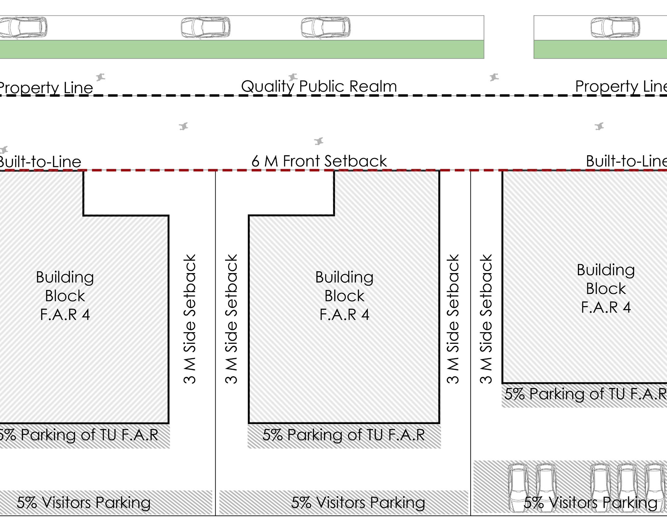
Project 1: Redefining building norms and reorganizing built fabric Fixed front setback and mandatory Builtto-line at 6 meters
Quality and active public realm is enhanced through redefining building norms and reorganizing built fabric. The informal settlement of the built fabric is regulated by fixing the front setback at 6M and introduce policy that enforces to construct built-to-line to encourage organized growth and maintain the hierarchy of the public realm. Thus, public realm is kept clear at 6 metres.
No boundary wall allowed at front setback/ margin
To keep the realm active and developing, front margin setback area is considered as public realm and thus policy of no boundary wall in front is imposed in the proposal.
Parking not allowed in front (allowed in basement or at rear side)
Additionally, the informal parking and land encroachment through on street parking is regulated by redefining parking norms and spaces in the zone. No parking is allowed at the front edge of the building. Since front margins are kept preserved for quality realm, rear side of the building and basement are used for parking. Side margins are kept at 3M minimum to increase the frontage of the building between 6080% to enhance the vision of the corridor. There is relaxation on off street parking requirement and 20% minimum permissible off street parking allowed
92 93
Project 2: Promote land use which encourages mixed-income and mixed-use housing development
Providing incentives to developers for encouraging affordable housing closer to the transit corridor
The land that comes under public ownership is considered for redeveloped in the area. To encourage the affordable housing development, incentives are provided to the developer which is to attract the new construction to introduce build fabric along TOD corridor.
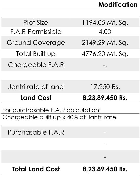
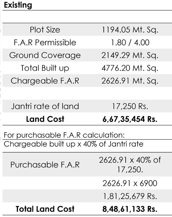
Introducing TOD zone as a primary zone
Introduction of the TOD overlaid zone as primary zone bypasses the premium on FAR payments and thus increases the acceptance of the development in the zone. The overlaid zone of TOD with 4 FSI is redefined as the zone whose base FSI is 4. The developers will be allowed to build upto 4 without any premium. Further, there will be relazation on premium on FAR. This is to allow developers to build high rise and utilized complete FAR as prescribed in the norms. This relaxation also leads to the development of affordable housing with in the zone which will allow people of low and mid income group to reside closer to the transit corridor.
94 95
Fig 59: Calculations for existing scenario
Fig 60: Calculations for modified scenario
Fig 61: Envisioned development along TOD
Project 3: Envisioned development along TOD Redefining land parcels
Depending on the key strategies and proposals, a certain pattern of development should come up in the area. The land parcels are redefined and redeveloped to enhance the local area as more likable space.
Mixed-use development along TOD
The zone was previously dominated by the residential section, which now have mixed touch of all section.
Particular sector like affordable housing and mixed used development is emphasized to come up and enhance the build fabric quality at the most. Increase in affordability of housing is practices in the area and kept closer to the corridor, to increase the acceptance of public transits and reduce the acceptance of private motors.
Active public realm
For an active social lifestyle, quality public realm is planned and designed with in the zone, that will also focus on encouraging the walkability. Mixed used development along TOD corridor. Commercial activities increased from 0.2% to 2%. Majority of residences are proposed as affordable housing along TOD.
96
Fig 62: Expected land use along TOD
REFERENCES
Books
Shirley Ballaney and Bimal Patel (2009). Using the ‘Development Plan—Town Planning Scheme’ Mechanism to Appropriate Land and Build Urban Infrastructure
W S N W Mohammad(2014). A review of variables of urban street connectivity for spatial connection
Abbas Master(2015). Ambitious Mumbai Project –Cluster Development for large scale Redevelopment of Urban Habitat
Christopher Kost (ITDP) Matthias Nohn (EPC) (2011). Better streets, better cities A guide to street design in urban India
Mr. Brian Hollingworth, Mr. Trevor McIntyre, Mr. Deepak Darda, Mr. Ashish Ghate, Mr. Bankim Kalra, Ms. Zohra Mutabanna, Ms. Astha Malhotra (2016) Consultancy Services For Developing Guidance Documents For Transit Oriented Development (Tod), Non-Motorised Transport (Nmt) And Public Bicycle Sharing (Pbs)
Reports
Ahmedabad Urban Development Authority, Draft Comprehensive Development Plan 2021. Retrieved October 6, 2017, from http://www.auda.org.in/uploads/ Assets/rdp/Basemap-36X36.jpg
Directorate of census operations. Census of India 2011- Gujarat. Rerieved October 6, 2017 from http:// www.censusindia.gov.in/2011census/dchb/2407_
PART_B_DCHB_AHMADABAD.pdf
98 99


