AMONGST THE RUINS
Why Civilizations Collapse and Communities Disappear
John Darlington
YALE UNIVERSITY PRESS New Haven and London
p. 13: Quotes from both The Tollund Man and Bogland by Seamus Heaney, from New Selected Poems 1966–1987 © The Estate of Seamus Heaney. Used by permission of Faber and Faber Limited. Used by permission of Farrar, Straus & Giroux, LLC, http://us.macmillan.com/fsg. All rights reserved
p. 13: © George Barnett, 1965, The Beaghmore Stone Circles from his collection of poems The Wee Black Tin, by kind permission of Graham Mawhinney
p. 36: By kind permission © Nicholas Comfort 1994 The Lost City of Dunwich published by Terence Dalton, Ltd
p. 156: Permission granted by Zehao Zhou to quote from his dissertation The Anti-Confucian Campaign during the Cultural Revolution, August 1966–January 1967 © Zehao Zhou
p. 180: © Bobby Troup/Warner Chappell Sync
p. 184: From The Grapes of Wrath by John Steinbeck published by Penguin Classics. Copyright © John Steinbeck 1939. Reprinted by permission of Penguin Books Limited. Copyright renewed © John Steinbeck 1967
p. 257: By kind permission © Graham Fairclough 2009
Copyright © 2023 John Darlington
All rights reserved. This book may not be reproduced in whole or in part, in any form (beyond that copying permitted by Sections 107 and 108 of the U.S. Copyright Law and except by reviewers for the public press) without written permission from the publishers.
For information about this and other Yale University Press publications, please contact: U.S. Office: sales.press@yale.edu yalebooks.com Europe Office: sales@yaleup.co.uk yalebooks.co.uk
Typesetting and eBook by Tetragon, London
Library of Congress Control Number: 2022948965
ISBN 978-0-300-25928-5
eISBN 978-0-300-27133-1
A catalogue record for this book is available from the British Library.
Contents Preface vii i ntro D uction: t he a natomy of l oss 1 1. c limate c hange 9 The Stone Circles of the Sperrin Mountains, Northern Ireland 11 Herschel Island – Qikiqtaruk, Canada 22 Dunwich, England 32 The Garamantes, Libya 41 2 . n atural h azar D s 53 Port Royal, Jamaica 55 Ani, Turkey 66 Plymouth, Montserrat 75 3 . h uman Disaster 87 Girsu, Iraq 89 St Kilda, Scotland 100 Rapa Nui (Easter Island), Chile 110 4 . War 125 Nimrud, Iraq 127 The Old Summer Palace, China 137 The Temple of Confucius, China 151
5 . e conomy 165 Humberstone Mine, Chile 168 Route 66, US 180 Beaudesert Hall, England 191 Abu Simbel and the Nubian Monuments, Egypt and Sudan 201 c onclusion 215 Understanding Loss and Renewal on a Global Stage 215 Learning the Lessons of the Past 234 Acknowledgements 261 Notes 262 Bibliography 269 Image Credits 280 Index 283
Preface
The best of Prophets of the future is the Past.
l or D Byron; D iary extract, 28 January 1821
Or alternatively:
Those who cannot remember the past are condemned to repeat it.
g eorge s antayana
Study the past, if you would divine the future.
c onfucius
The past resembles the future more than one drop of water resembles another.
iB n Khal D un
At times it feels like the past is filled with a cacophony of voices warning about how important it is to learn from the past. Indeed, there are at least 300 familiar quotations which champion the relevance of history to the future.
However, there is a counterview that it is impossible, fruitless even, to try to treat what has happened previously as a useful barometer for what will happen next:
If men could learn from history, what lessons it might teach us! But passion and party blind our eyes, and the light which experience gives us is a lantern on the stern which shines only on the waves behind.
s amuel t aylor c oleri D ge
That men do not learn very much from the lessons of history is the most important of all the lessons of history.
vii
a l D ous h uxley
And, of course, there is always the ever-quotable Mark Twain, who remarked, ‘The past does not repeat itself, but it rhymes.’ My favourite, however, and a reason for writing this book, is from an anonymous source: ‘History repeats itself because no one was listening the first time.’ Clearly, I am firmly in the camp that claims there are valuable lessons to learn, it’s all about asking the right question. How can we train ourselves to pay better attention to those voices of yesteryear, particularly during times of collapse and crisis, or ahead of them?
This book explores some of the ways that we can draw from the past, both philosophically and practically, to help plan for and guide the future.
viii amongst the ruins
The Anatomy of Loss
Ruins lie at the heart of this book. Mutely eloquent reminders of our immortality, they are memento mori on the grandest scale. They are the architectural car crashes of the past which we rubberneck from the present, whispering ‘there but for the grace of God go I . . .’.
Ruins represent our failures: civilizations that have collapsed, communities who moved out or were forced to move on, or the abandoned dreams of despots, democrats and the divine. But, given that time is relative, and all buildings will eventually end as dust, they are also our successes, notices marking the extraordinary achievements of humankind. Ruins prompt questions: what person visiting the red sandstone facades of Petra’s Treasury would not ask why or how? Machu Picchu, Chichen Itza and Angkor Wat inspire because we want to know more about the people who built them. And, while they signify lives lived long ago, they also tell us something about where we are heading. Ruins are libraries, abandoned books that divulge stories about what happened decades, centuries or millennia ago, and which are repeated today. The outcome may not be the same, but we would be arrogant to ignore the lessons of history.
This book is a search for the present and future in the past. In it we will explore the loss of ancient civilizations, the collapse of ruling elites and the disappearance of more recent communities.
This is a vast subject. Edward Gibbon needed six volumes for his History of the Decline and Fall of the Roman Empire (1766–89),
1 Introduction
which has now been reprinted countless times. A search of the internet using the phrase ‘fall of empire’ will bring up thousands of books, videos and films documenting the stumble, trip and sprawl of the powerful, from the Aztecs and Incas through to the empires of the British, Soviets and Americans. Flick through the pages of any atlas of world history and be overwhelmed by the growing bloom and subsequent shrivelling of colours depicting the tread of ancient Mesopotamians, Mongols, Umayyads, Spaniards and Portuguese, amongst many, many others. The last imperial Chinese dynasty stretched over nearly 15 million square kilometres at its greatest extent (the Qing Dynasty in 1790 ce ), and doubtless more still will be written about modern China, the twenty-first-century global superpower, when its time has passed.
These are fascinating approaches, but I am interested in the explanations that underpin why ancient and more recent civilizations disappeared. How did we reach the ruin? What are the reasons behind the fall, or the shrinking frontiers in the atlas? And, as importantly, is there a commonality to that loss that might help us today?
In response to that challenge, I have selected seventeen places from across the globe that illustrate specific stories of decline and
2 amongst the ruins
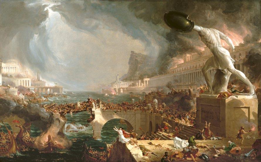
Fig. 1 ‘Destruction’ by Thomas Cole from The Course of Empire series, 1836. This, the fourth in a series of five paintings on the subject of the rise and fall of civilizations, shows barbarians sacking a classical city. It is followed by ‘Desolation’.
collapse. Some will be recognizable and well known, but most have been chosen to touch on the fascinating variety of heritage across the world and the connections between people and disappearance. The book is divided into five organizing themes which seek to corral the causes of loss: climate change, natural hazards, economics, human frailty and war. Selected because they are the most cited reasons for collapse, the categories overlap, with human decision-making influencing them all. Critically, there is rarely a single explanation for why civilizations fail. The cumulative impact of multiple causes is acknowledged from the outset, where one disaster compounds another, often leading to a catastrophic downward spiral. Some stories will speak solely to the organizing theme, but where there are multiple causes, the theme may be the most significant, or the trigger for decline, or will introduce an important and interesting line of discussion.
My scope is broad. Our raw materials are the physical remains of architectural and archaeological heritage, but I touch on intangible cultural traditions, particularly in the last chapter where I explore the inevitability of future loss in which it may be impossible to retain even the ruins of the past. Here, taking the past with you in the form of the activity, be it an idea, a function, a dance, recipe or song, as opposed to bricks and mortar, becomes an important option.
My chronology and geography are wide-ranging too, with some stories sealed under 3,000-year-old peat and others that are told through the carcasses of twentieth-century buildings. I take in most of the world’s continents, from the ice of the Arctic fringe, through to the desert landscapes of North Africa, by way of South America’s high mountains and Southeast Asia’s urban sprawl. Not all the tales are told at the same speed. Some are about instant catastrophe, the minutes it might take an earthquake to destroy a place; others are about a gentle implosion, the architectural equivalent of taking an undercooked soufflé out of the oven; yet more still are about a decline which is so slow that those living through it are not even aware of it. But importantly, all the stories contain lessons that are applicable well beyond the sight of their tumbled walls or abandoned landscapes.
Nor are all the stories told at the same scale. Sometimes the headline is about a civilization – the Sumerians, for example, who
3 t he a natomy of l oss
once dominated what is now southern Iraq. Here, through the lens of the abandonment of the city of Girsu, we will explore the impact of salinification on a sophisticated agricultural system that once supported a large population. Alternatively, the story might focus on a stratum of society as told through the loss of a single building – Beaudesert Hall: the fall from power of the landed ‘gentry’ in England due to taxation, economics and changing social attitudes. Or it might be about the loss of a community because the raison d’être of that community has disappeared, as in the case of Humberstone in Chile, which was abandoned when the saltpetre mined there was rendered obsolete by new materials manufactured elsewhere.
A depressing subject? If this book were a film, it might be introduced by credits warning ‘ May contain scenes of doom, death, decline, disaster . . .’ – a decidedly downbeat alliteration. At first glance the topic is all about failure: our overexploitation of the earth’s natural resources, our response to the inevitable impact of building homes on the slopes of a volcano and in the places where tectonic plates collide, or our tribal urge to destroy the neighbours. The body count adds up. There is definitely an element of schadenfreude in the telling of these stories, but we should not enjoy them as tales of horror, something which happened a long time ago that is somehow detached and irrelevant today. This feels like sitting in an idling car and complaining about the traffic jam – we are the traffic. The fact is that many of the stories concern trends and patterns that are present, if not amplified, in our current world.
But I also don’t want to paint a picture that is all doom and gloom. Human ingenuity in the face of adversity is inspirational and is told in part here, as are the multiple adaptations to changes that made life more difficult for ancient peoples across the world. Run out of water? Use technology to search for it deeper in the earth or dam valleys to capture it in the winter for use in the hotter summer months. Too much water? Build above it, divert it or use windmills to pump it elsewhere. The geography of the 17 per cent of the Netherlands that has been reclaimed from the sea is founded on just such ingenuity. There are limits to where humankind can and cannot live, but these have always changed. What worshipper of Luna, Khonsu, Artemis, Máni, Chandra, Tsukuyomi-noMikoto or Metztli – gods and goddesses of the moon from across
4 amongst the
ruins
the world – would conceive we could land on its stony surface and succeed in returning to the mortal world?
There is also that question of timescale. For example, to view the decline of the Roman Empire as a long and relentless progression of disasters ignores both its peaks and the positives. And that is if we can agree what triggered it, and when, and what marked its final dying breath. Gibbon’s classic, Fall of the Roman Empire, covered a period of 1,500 years, and he firmly fired the starting gun for the crisis in 376 ce when large numbers of Gothic peoples began crossing the Rhine. Most mark 476 ce to be the death knell, when the barbarian king Odoacer overthrew the teenage Romulus Augustus, the last emperor of the Western Empire, and the Senate sent the imperial insignia to Flavius Zeno, his counterpart in the Eastern Empire. But of course, the collapse of the Western Roman Empire was then succeeded by the flourishing of the East: ‘Rome did not fall in the fifth or sixth centuries. It changed and multiplied itself . . . It may have been a chameleon, but it was certainly no phoenix, because there were no ashes.’1 Others see the origins of decay much earlier, in the loss of power of the Republican democratic institutions, the moment Augustus declared himself princeps civitas, first amongst the people, in 27 B ce . 2 Still more point to the Muslim conquests of the eighth century as the beginning of the end.3
Perspective is important too: using the same example, who suffered from Rome’s decline? Certainly not the Gothic peoples who had been pushed out of their lands by the Huns, nor perhaps many of the people working on the trading routes of the Mediterranean, where the short-term interruption of political events could be overridden by the need for bread, wine and oil. Many now see this period of Late Antiquity as a time of change between the classical and medieval worlds, with plenty of continuity in everyday life, interspersed by events that impacted dramatically on the political and religious leadership.
The point is that the concept of decline is a moving target, sometimes clear-cut – the break-up of the Soviet Union, the fall of Nazi Germany or the collapse of the British Empire – but often the path to ruination is uneven, messy and complex.
A final point on the tone of this exploration into the loss of civilizations is that it is written from an archaeological perspective.
5 t he a natomy of l oss
What does that mean? It means that archaeologists have a long body clock. We work not to years nor decades, but to centuries and millennia. Ours is a slow heartbeat, where the important issues of each era are filtered out from the day-to-day by the inevitable reckoning of time. Consequently, we see change as the only constant in history. And in the context of such a long view of the past, every civilization will eventually turn to dust. To continue our Roman analogy, we are blessed with some remarkable monuments dating to the period: from the Colosseum in the imperial capital, through to Baalbek’s temples, Ephesus’s Great Theatre and Hadrian’s Wall. But these monuments are the stubborn survivors of literally millions of buildings that once existed, the tiniest fraction of an architectural heritage that has entirely disappeared. The others, which ranged from simple wooden homes to stone-built palaces, have either decayed or have been demolished, reused or built over. Nothing lasts forever. One day, ideally in the unimaginable distance of the future, the Pantheon will eventually succumb to the ageing process of time. If a similar prognosis is offered for all our physical cultural legacy, then immortality is born of the passing on of ideas. We celebrate the architecture of the past in our own moments, seek to conserve that which we value now and, at the same time, try to predict what future generations will cherish.
6 amongst the ruins

Climate Change
Given the urgency of the current climate crisis, we tend to frame change in the present or the recent past, and on our own actions that have accelerated or will slow it. But, regardless of the undeniable impact of human influence, the planet’s climate has been changing since before humans walked the earth. Four stories of the disappearance of historic cultures are presented here, which each explore how communities have responded to climatic conditions that have been getting incrementally cooler, wetter, warmer or drier.
First, we step back to the Bronze Age and see the impact of climate change on the pastoral Bronze Age peoples who inhabited the slopes of the Sperrin Mountains in Northern Ireland. Here at places like Beaghmore and Copney a remarkable assemblage of stone circles, alignments, avenues and cairns are to be found hidden underneath the moorland peat, symbols of a wider hidden landscape lost to the onset of the wetter, colder climatic conditions of the Late Bronze Age (1200–650 B ce ). How did this happen, what was our human contribution, and how did we respond?
Next, we will turn to Herschel Island (Qikiqtaruk) off the Yukon coast of Canada, where a warming climate rather than a cooling one is the issue. Used as an Inuvialuit hunting base for centuries, and more recently established as a commercial whaling station, Herschel was all but abandoned after the market for whale oil collapsed in 1907. Now increased global temperatures are presenting new challenges to
9 Chapter 1
preservation, with rising sea levels sweeping away both European and earlier culture, and thawing permafrost accelerating the discovery and destruction of once frozen archaeology. Permafrost covers almost a quarter of the Northern Hemisphere, including Alaska, much of Canada, and Siberia. It contains within it the remarkably preserved remains of earlier peoples: evidence that is desiccated and lost as the permafrost disappears. This will be one of the biggest and least appreciated losses of global cultural heritage in future times.
Coastal climate change is graphically illustrated in our third story, using the example of Dunwich off England’s Suffolk coast. Listed in the Domesday Book of 1086 as one of the ten largest towns in the country, Dunwich once had a population of over 5,000 people and eighteen churches and religious institutions. Now, just two churches remain, and fewer than 200 residents, the remainder of the town being lost to the sea. Again, the question is asked, how did the people of Dunwich respond to the slow death of their town?
From too much water, to drought, the final story under the theme of climate change describes the equally destructive impact of a warming, drier environment on heritage. The Garamantes’ empire once stretched for 647,500 square kilometres in the Saharan area of Libya and North Africa. Originating from Berber tribes in the Iron Age (200 B ce ) and rising to regional prominence in the second century ce , the Garamantes were described by Herodotus as ‘a very great nation’. Despite Roman propaganda which sought to depict the Garamantes as barbarians, they inhabited a powerful and sophisticated kingdom with a capital that was home to 10,000 people. The Garamantes’ success was built on their sophisticated water management system, but in the fourth century ce a drying climate, coupled with the overexploitation of a diminishing supply of water and the increasing numbers of slaves required to maintain it, led to their slow decline and eventual disappearance. Depleting water supplies, or their salinification, and the loss of civilization to sand, is a little-told story that can be repeated across the desert regions of the world.
Climate change will be the biggest global driver of loss of heritage over the coming decades, whether through inundation by water, sand and salt, or because places that were once inhabitable are no longer so, leading to their abandonment. These four stories
10 amongst the ruins
underpin the importance of learning from the past in the face of a changing climate, or as expressed in this adapted version of a Native American proverb: ‘We not only inherit the land from our ancestors, we borrow it from our children.’
The Stone Circles of the Sperrin Mountains, Northern Ireland
Lost worlds have always captured the imagination, whether the mythological romance of Atlantis and Eldorado or the extraordinary revelations of new technologies, which allow us to see the true extent of the Angkor Archaeological Park in Cambodia under its thick canopy of trees and Dunwich in the murky water on the edge of the North Sea (see below). However, there is another lost landscape that we often miss because it is covered not by water, plants or volcanic debris, but by peat. Globally this inland ‘sea’ covers 4.2 million square kilometres,1 the equivalent of seventeen times the land area of the United Kingdom. Peat is slow to grow, accumulating at approximately one millimetre each year, and has featured in our
11 c limate c hange
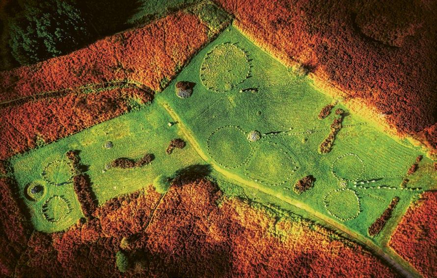
Fig. 2 Beaghmore circles from the air showing a variety of stone circles, cairns and alignments. The contrast between the remaining russet-covered peat and green grass of the excavated area is stark.
landscapes since the end of the last glaciation some 15,000 years ago; from a modern perspective it therefore has the appearance of permanence, a soft version of geology. But it is inextricably linked to humans who lived before its formation, and whose world lies buried under its dense brown blanket.
Fortunately, a bog is a goldmine for archaeologists because it locks in so much information not only about its own origin and growth, but also about what went on in the wider landscape. Any water-saturated deposits have the potential to preserve evidence from the past that desiccates, disintegrates and disappears elsewhere. The cold, wet and oxygen-lite nature of peat slows down the rate of decay of organic matter, so preserving many things that fall within its damp, fibrous grasp. It is estimated that archaeologists working in peatlands may find up to 90 per cent of the material culture of ancient communities contained within it, as opposed to 10 per cent of those working on dry land.2 A peat bog can therefore be a library of the past holding airborne pollen that precisely documents changes to the surrounding vegetation; seeds and plant material telling us about diet and materials; the wooden posts and platforms of ancient homes; even the bodies of people themselves, often beautifully preserved but disconcerting victims of prehistoric ritual. The carbon in the peat gives us dates, while the identifiable marks of bog growth and contraction tell us something about the climate over millennia. But peat is selective, in overly acidic conditions the soil can quickly eat away bone and antler and destroy certain metals, particularly if they are subjected to repeated wetting and drying.
Bogs don’t just appear, they are living things, requiring the right combination of wet, cold and poor drainage, and the right type of wet – in this case acid rich and nutrient poor, mainly falling as rainfall. There are several different types of peat bog in the UK and Ireland and their growth is complex, but they may be simplified according to how they form. Raised bogs, as seen in the west of Ireland, tend to form from the slow infill of lakes where marginal plants slowly decompose to slowly choke and absorb the water body. Sphagnum moss gradually takes over, growing and dying back annually, with new sphagnum mounting the rotting but partially preserved former growth. Raised bogs or fen peat can be as much as ten metres deep, many forming at the end of the last Ice Age around 8000 B ce . Blanket
12 amongst the ruins
bogs on the other hand are often younger and shallower-growing during the Neolithic and the Bronze Age. They were created as a result of tree clearance which, with high rainfall, led to increased impoverishment of the soils. Minerals, particularly iron, washed through the soil horizon, forming a hard, impenetrable pan that trapped water above. Trees struggled to regrow in this soggy new environment, but marsh vegetation thrived, including the ubiquitous bog-forming sphagnum.
Ireland is renowned both for its raised and blanket bogs, which by turn contain a rich reservoir of archaeological sites. The Irish Archaeological Wetland Unit identified 3,462 sites in 45,000 hectares of peat bog, equating to 7.7 sites per square kilometre,3 a figure that is far higher than English counterparts and likely to be an underestimate. The peat, and things contained within it, were a consistent theme for the poet Seamus Heaney, who grew up on a farm near bog country in Northern Ireland. Aside from arguably his most famous poem, ‘Digging’ (1966), he frequently returned to this subject, writing of the ‘Trove of the turfcutters’/Honeycombed workings’ (‘The Tollund Man’, 1972), inspired by the discovery of a bog body in Denmark in 1950, where ‘Every layer they strip/Seems camped on before’ (‘Bogland’, 1969). George Barnett, a slightly less celebrated poet, was fascinated by the same:
Around by Blackrock in the County Tyrone, Are numbers of circles and big standing stones, At Michael McMahon’s they stand by the score, About his wee farm, around by Beaghmore.
The stones were set up before any peat grew, And just have a look and you’ll find it is true, The most of them’s neatly set up on their end, And some people say, by the bold ‘Beaker-Men!’4
Barnett, an amateur archaeologist and folklorist, first drew attention to the stone circles of Beaghmore, County Tyrone, in Northern Ireland, during the 1930s. As today, local people on the fringes of the Sperrin Mountains have long held rights of turbary – originally medieval entitlements to cut peat for fuel – from the blanket bog,
13 c limate c hange
and it was while out observing this traditional practice that Barnett identified what was to turn out to be one of the most extensive prehistoric landscapes in Ireland.
After Barnett’s initial identification, Northern Ireland’s state heritage service commissioned a series of investigations to understand more about the site. Excavations from 1945 to 1949, and again in 1965, slowly uncovered not one but seven stone circles hidden under the peat. These represented a Neolithic and Bronze Age world that clearly pre-dated the damper, wetter conditions which prompted the growth of the blanket bog.
The first signs of human activity at Beaghmore belong to the Neolithic, 5,250 years ago, when people cleared small patches in the native birch, willow, pine and hazel woodland and settled in the area. They were early farmers, probably living in seasonal camps and making the most of the easily cultivated sandy soils for simple cultivation alongside a largely pastoral existence. Most likely they hunted, fished and foraged too, making the most of the wild resources as well as benefiting from early domestication. We don’t know a great deal about them, except they used stone tools, cooked in hearth pits and divided up the land into fields, marked by boundaries made from stones cleared from the area. They abandoned the hillside at Beaghmore by the early third millennium and there was a hiatus before the arrival of the stone circle builders after c. 1500 B ce . 5 We know much more about these new settlers because they left behind a ceremonial landscape that bears comparison with similar sacred places in Scotland, Wales, Southwest England and Brittany. These Bronze Age folk were part of a migration of people or ideas (there is a lively and continuing debate as to which – the joy of archaeology is that our documents are the material cultures of the past, which leave enormous scope for disagreement!) that originated in eastern Europe, bringing distinctive types of pottery, funerary traditions and new metalworking skills in copper, bronze and gold.
At Beaghmore we have no sight of the houses that the new settlers lived in, nor their farms and industries; instead, we have their spectacular sacred place. Stones gathered locally were used to create ceremonial circles, either by placing them on the ground or setting them upright in simple foundation pits. These are not of the same scale as the great circles at Avebury in Wiltshire, or Brodgar on the
14 amongst the ruins
Isle of Orkney, ranging between 11 and 18 metres in diameter, and even the largest standing stone is around 1.2 metres high, but they are unique and highly distinctive.
Six of the seven circles were paired, and all of them were associated with smaller burial cairns, made from stone rubble, again collected from nearby. The cairns were kerbed with small boulders and most contained cremated human remains. The single circle is markedly different from all the twins: it is larger, both in diameter (18 metres) and in the size of the principal stones, some of which stand up to 1.2 metres high, and the whole of its interior is filled with 884 smaller stones, each set upright. As ever, there is much speculation about the purpose of the ‘dragon’s teeth’, as the smaller stones are known, with the most likely explanation being that they prevented people accessing burials placed at the centre of the circle.
Stretching out from the stone circles and cairns were at least ten alignments of standing stones, some made up of numerous small stones which extended 50 metres into the unexcavated peat and were paired with a shorter row of larger stones. Four of the rows led
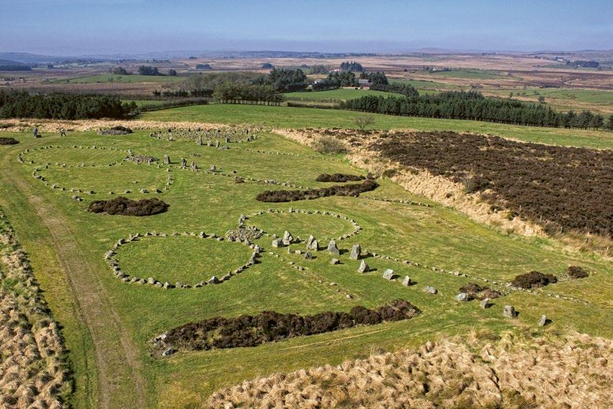
Fig. 3
circle and cairns. Here two sets of twinned stone circles have a cairn in between each pair, and both large and small stone alignments running in short and longer lines from them. In the background is the ‘dragon’s teeth’, a circle filled with nearly 900 smaller stones.
15 c limate c hange
Beaghmore
directly from the burial cairns and were all parallel, each pointing from the cairn towards the northeast horizon.
When Beaghmore was first excavated, the presence of stone circles in Ireland was limited, and Beaghmore’s dragon’s teeth circle was believed to be a one-off. However, research conducted over the second half of the twentieth century and the beginning of the twenty-first century, has revealed that Barnett’s discovery on the fringes of the Sperrins was not an isolated example.
On Copney Hill, ten kilometres southwest of Beaghmore, a further nine stone circles, possibly ten, were found following identification in 1979.6 Known by local turf-cutters, who recognized the tops of the taller stones peeping through the peat, part of the site was cleared of peat in 1994, and three of the largest circles were excavated a year later. The ambition was to open the site to the public. Underneath the turf, all of the excavated circles revealed more sophisticated versions of Beaghmore’s dragon’s teeth, with the largest stones on the perimeter and interiors filled with smaller standing stones. In two of the circles, the inner stones were set in
16 amongst the ruins
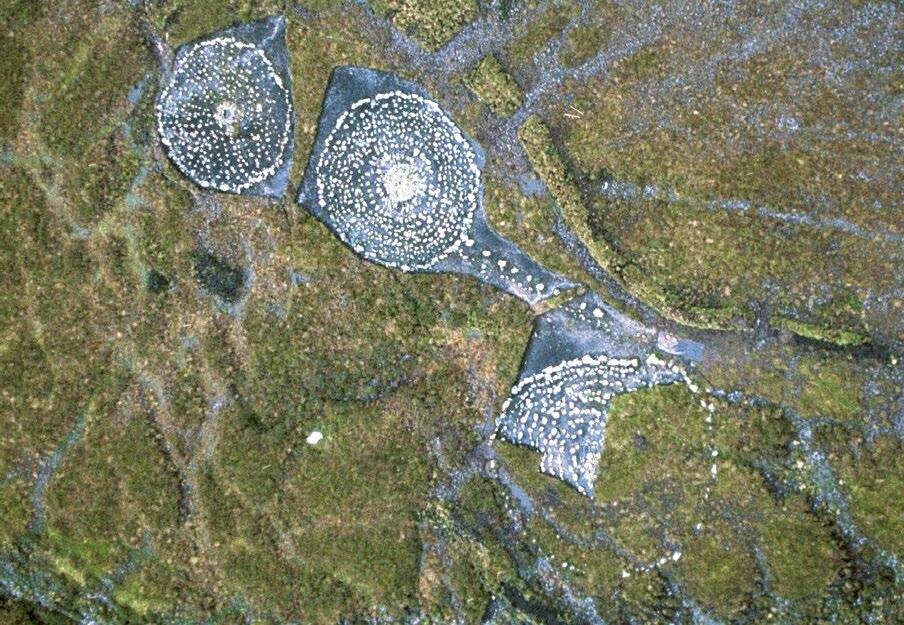
Fig. 4 Three of Copney’s nine stone circles and a double stone alignment revealed underneath the peat after excavation. Each circle has a central burial cairn and an interior filled with smaller upright stones reminiscent of Beaghmore’s dragon’s teeth.
ever decreasing circles and culminated in a central burial cairn, as if focusing on a bullseye. In the other circle, the inner stones radiated out in semi-straight lines from another centrally placed cairn. The six unexcavated circles are much smaller, none being greater than 10 metres in diameter, compared to the largest which stood at 24 metres. A double alignment connected two of the excavated circles, with one row made of smaller stones next to a larger neighbour, exactly as at Beaghmore. Interestingly, the alignment of the row to the southwest was not the same as its counterparts to the northeast.
Beaghmore and Copney are the most impressive complexes discovered in Northern Ireland to date, but they are not the only ones. More circles, cairns and stone rows are to be found across the region. Moymore, also in County Tyrone, has at least nine circles, all clustered together, with two stone alignments at right angles to one another, one typically consisting of a double row of smaller and larger stones. The Northern Ireland Sites and Monuments Record (NISMR) lists over 110 circles from seventy-nine separate sites, many small at around ten metres in diameter and all made up of low stones rather than large monoliths, although there are occasionally larger separate ‘sentinel’ stones overlooking their smaller collected companions. Interestingly, there are almost no other stone circle complexes of this type – small, modest and in multiples with rows and cairns – found in the rest of Ireland – the tradition appears to be one centred on Counties Tyrone and Derry/Londonderry in the north.7
So, what are they? The joy of prehistory is that there is no documentary record to conclusively prove or disprove theories of past use, so we are reliant on the science and imagination of archaeologists to unravel the past. An archaeologist’s raw ingredients are the material remains that we humans leave behind. This includes everything from the ruins of our ancestors’ temples and the stained ground of a disintegrated building to the fragments of shattered cooking pots or the dead sparks of hammer-scale that once flew from a blacksmith’s forge. But such evidence is ephemeral and highly selective: wood rots, metal decays, even stone fractures, delaminates or is carried away for reuse; and so the archaeologist is left to decipher a jigsaw in which most of the pieces are missing. If human material remains are the raw ingredients in the archaeological cookbook,
17 c limate c hange
then the techniques that convert them to the food of theory include non-intrusive fieldwork, often carried out at a landscape scale to map the ‘lumps and bumps’ of mute earthworks; buildings recording, essentially archaeology on the vertical scale; and an increasingly large armoury of scientific techniques that aid everything from dating using tree-rings through to determining the original source of stone axe, quern (hand-grinding stone) or menhir (a large, upright standing stone). Excavation is usually seen as the signature technique of the archaeologist, but in reality it is often the final resort, notably because it is expensive and its very act destroys the evidence it seeks. Excavation dismantles the chronology of a place, peeling back and removing layers of activity to find and record that underneath. It is the equivalent of tearing pages out of a precious but incomplete book and attempting to reconstruct its story through the memory of snatched phrases, occasional paragraphs and rare pages. The digging archaeologist is therefore a masseur of earth, a rigorous copyist and the ultimate slash-and-burn scientist. And archaeological excavation can only ever be a translation of a copy . . . of a half-truth . . . of an original event from the past that can never be revealed.
Where does this leave our understanding of the stone circles of the Sperrins? All the sites have several critical characteristics in common, which are the anchors for interpretation: firstly, they are consistently associated with burial cairns, places where a few people have been interred, rather than the graveyards of the many. Secondly, there is clearly a deep connection between the cairns, the stone circles and the stone alignments – these are ensemble landscapes, not necessarily designed contemporaneously, but cumulatively, with each phase recognizing and building on its predecessor. There is also a relationship with earlier and later landscapes, in which they ‘not only reached back to the Neolithic but foreshadowed others of the Iron Age’.8 And their conformity of size, construction and materials across an area suggests that their builders were tribes of people, who shared the same values, societal structure and leadership. Thirdly, they all appear in similar geographical locations, almost all above 150 metres (500ft contour) on rough, hilly ground. Fourthly, the stone rows connected the sites with something beyond the horizon, their alignment was an important part of Bronze Age life. And finally, aside from the evidence of earlier Neolithic field systems underneath
18 amongst the ruins
the circle-builders, complex, there is no contemporary evidence of domestic living: no homes, hearths or rubbish pits. People were not making things here, nor were they sleeping, cooking, tending animals or trading amongst the stones.
So what were they doing? There is a longstanding joke amongst (and about) archaeologists, in that we cry ‘ritual’ when we come across anything that we do not understand. But this is undoubtedly a ritual landscape. Its defining attributes allow us to fashion a story of mid-to-late Bronze Age peoples using the marginal semi-uplands of the Sperrins as spaces for veneration. This was a setting for burial, a sacred place strongly associated with the seasons, a place to connect with the ancestors, a place to meet and remember the past, and maybe to make decisions about the future.
George Barnett, the champion of Beaghmore, felt that the circles and alignments there were part of an astronomical calendar. He even built a replica in his garden to test the theory – a model that he later replaced in 1962 with a full-size replica of Stonehenge, made of wood and painted blue and white.9 There is a consistent orientation between some of the rows, the cairns and the winter solstice,10 but the relationship between the circles, their interior variations and the outlying dolmens is unproven, and probably unprovable.11 A further challenge to this theory is that while there is some consistency of alignment at individual places, the same is not necessarily true between them: for example, at Beaghmore the rows align northeast from the cairns, whereas at Copney they align southeast. It follows that they were unlikely to be pointing at the same thing. However, on a broader scale, the role of the seasons and the course of the sun and moon must have had a significant impact on Bronze Age peoples. What other way would there be to measure the day, the agricultural calendar or the passing of the years? Synchronization with the sun is reflected elsewhere in the architecture of Bronze Age society – the doors of the domestic round houses of the era found elsewhere consistently face the south side of the buildings to catch the sun, while sleeping areas are most often to the north and east, the side of darkness and first awakening. The same position is reflected in Bronze Age burials.
So, the stone circles of the Sperrins were sacred places of burial and veneration, but they were not places of habitation. Their placement
19 c limate c hange
was conscious, seemingly away from the homes of their builders on marginal land in open landscape, giving long views. This is a common Bronze Age characteristic in which ceremony and ritual took place in transient zones – marshes, lakes, tidal foreshores and boggy hillsides – separate places on the edge of the living. The next research objective must be to find evidence of the everyday to complement the stony ritual landscape of the circle builders.
The liminal nature of these Bronze Age ceremonial landscapes gives a hint to the next episode in this story of loss – changes that marked the difference between marginal and uninhabitable, leading to abandonment of the sites. The key to understanding is the wetter, colder conditions that led to the arrival of peat and the long boggy invasion that was to eventually hide the earlier prehistoric landscapes.
What happened to the Bronze Age ceremonial landscapes in the foothills of the Sperrin Mountains? An early theory pointed to a very direct correlation between clearance, climate and abandonment. Bronze Age farmers continued to clear the land of trees for growing crops
20 amongst the ruins
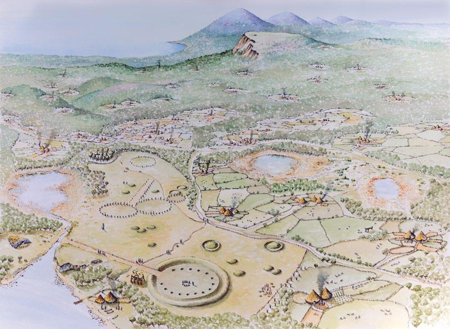
Fig. 5 Reconstruction of a late Bronze Age landscape in Northern Ireland showing ceremonial landscapes of stone circles, alignments, burial cairns, barrows and henges on cleared tracts of upland, with villages and farmed land on lower ground.
and grazing, which eventually led to soil exhaustion and hastened –by a colder, wetter climate – the irreversible formation of peat. The reality is a little more subtle. Evidence from Beaghmore suggests that the climate was already deteriorating before the circle builders erected their stones and placed some of them over their dead, with the mountainside location already being seen as marginal land. Their final departure, probably sometime in the eighth century B ce , may have been hastened by societal change, exacerbated by a changing climate and exhausted soil conditions. It is easy to see how all three factors can be interrelated, with climate and soil pressures on food supply impacting upon social hierarchies, leading to conflict, migration and abandonment.
Once the peat started to form it built a thick blanket that slowly consumed first the lowest monuments, growing until in some places even the tallest stones were covered. That landscape remains true today, excepting where it has been reclaimed in pockets for agriculture or converted to a crop of coniferous forest, both of which would require draining, or more recently, where it has been harvested as a garden conditioner and for fuel on a commercial scale. Of course, peat cutting by individual families is evident throughout the area, and in a sense it is this that brings us full circle, because the vast majority of discoveries of the Sperrins’ prehistoric landscape has initially come to light when local turf-cutters have come across the buried arrangement of stones.
The story of the stone circles of the Sperrins is not over. The presence of this prehistoric landscape has only been given away by the tops of the tallest stones peeping above the peat, like the highest peaks in a mountain range showing through the cloud, or revealed by the serendipitous slice of the turf-cutter’s tairsgeir (spade). We are only seeing a fraction of what is possible. More circles, cairns and rows will lie under the brown refuge of the peat awaiting discovery. Advances in archaeological prospecting using geophysical techniques, especially ground penetrating radar, may be a key to unlocking this hidden world. Science that allows us to see through the peat without excavating it, and to identify the contrasting pre-bog land surface with its stone-built ceremonial landscape, would significantly increase our understanding of the Bronze Age in Northern Ireland.
21 c limate c hange
Ironically, there is an advantage in not physically revealing more of the Sperrins’ circles. The Copney site was excavated in 1995. Since then, the exposed stones, particularly the smaller ones, have shown signs of deterioration.12 Recent frost action, causing the stones to crack and spall, may be added to the negative weathering effects of being buried in an acidic soil. That decay may slow down as a new outer edge hardens on the stones, but is unlikely to stop.13 Unwitting accident, blundering livestock, vandalism and the action of rogue vehicles are equally good arguments for leaving the heritage in the soil, but these threats are surely trumped by allowing the public to experience something of the spirit of the place that our ancestors felt over 3,000 years ago.
A far bigger threat to these sites, and all the heritage held or covered by the peat, is climate change. Some of the raised bogs and peat moorland of Ireland and the United Kingdom have been in place for over 10,000 years. Global warming could change that, reversing peat growth and thereby releasing millions of tons of trapped methane into the atmosphere, contributing another greenhouse gas to an already devastating mix.
In the lee of the Sperrin Mountains, the impacts of a warming world could re-expose a prehistoric landscape that was lost in the past, in part, due to climate change. Such a ‘reveal’ would be an equally catastrophic portent for the future of our own civilization.
Herschel Island – Qikiqtaruk, Canada
Communities at the edge of the world are the most vulnerable to change. Those that live on the margins of land and water, or at the extremes of human habitation, will always be the first to see the future. One such group is the Inuvialuit people, an indigenous Inuit group living on the fringes of frozen earth and an ice-clad sea on Canada’s northern arctic coast. This is a story of a warming climate and its impact on the Inuvialuit and later European and North American settlers. As with so many of these stories, there is no single reason for change and abandonment, so our main focus here is on the slow thawing of the permafrost, a ground condition that covers almost a quarter of the northern hemisphere, and its implications for cultural heritage.
22 amongst the ruins
The earliest occupation of what is now Alaska and northwest Canada was by palaeo-arctic peoples who migrated across the landbridge that connected with Siberia from c. 12000 B ce . Later, after ice-age meltwaters flooded the link to Russia, the area saw the arrival of successive cultural groups such as the Dorset (800 B ce –1300 ce ) and Thule peoples (900–1700 ce ), the latter migrating along Canada’s arctic coast from Western Alaska from around 1000 ce . The Thule are the direct antecedents of today’s Inuvialuit.
The area of northern Canada stretching from Herschel Island –Qikiqtaruk in the Yukon to the Mackenzie River Delta in the Northwest Territories is the historic heartland of the western Inuvialuit. By the nineteenth century they were divided into eight distinctive regional groups, each exploiting slightly difference resources and each focused on a central winter village. To the west, off Herschel (Qikiqtaruk), the Inuvialuit sought the bowhead whales, while in the east the communities of the Mackenzie Delta targeted beluga whales who favoured the shallow, warmer and less salty estuarine waters to moult, feed and give birth. The importance of the whale to the indigenous people of the area cannot be underestimated. A single bowhead yearling could provide up to 10,000 kilograms of meat, blubber
23 c limate c hange
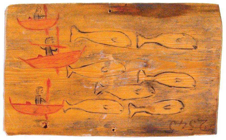
Fig. 6 A mid-nineteenth-century painted wooden plaque showing Inuvialuit hunting beluga whales. Three men in kayaks drive a pod of whales into shallow water, with one preparing to use a harpoon.
and skin, as well as a significant quantity of baleen and bone which could be used for tools, buildings, sledges, art and artefacts.14 They also hunted and trapped a range of other animals including seals, caribou, moose, a huge assortment of fish (fifty-five varieties including arctic char, cod, cisco, whitefish, trout and salmon), waterfowl, muskrat and arctic fox.
For the majority of these communities there was a seasonal rhythm to life, with groups coming together in the late summer and early autumn for the whaling season. Afterwards most would move inland to hunt migrating caribou, returning to their homes to see out the dark days of winter. With the return of longer days, groups would move out onto the sea ice in search of seals, living in snow houses or caribou-skin tents. One thousand years of occupation by the Inuvialuit and their forebears has left a fascinating material culture, particularly from the fifteenth century onwards. The remains of halfsunken buildings, constructed into a slope and covered with sods, are the most substantial reminders of Inuvialuit life – indeed they are the largest buildings belonging to the Inuit cultures of the Arctic. Made of wooden planks and driftwood logs, these igluryuaq, or winter houses, were often cruciform in plan with three raised benches or chambers leading off a central space. The smaller benches would be used for working or eating, while the larger platforms were also for sleeping. Sometimes an additional chamber would lead off the central one, and was used as a kitchen. The igluryuaq were entered by a long (often up to eight metres) access tunnel that at first sunk into the ground before rising into the central chamber, and acted as a ‘lock’ against the cold outside. Inside, a fire could be lit and extended families (up to six in the larger igluryuaq) could hunker down during the colder winter months. Other buildings included qadjgiq (also known as karigi or qargi), large communal subterranean structures, used mainly by men as a mixture of council house, sweat lodge, dance hall and schoolroom. Typically, these were 15–20 metres long, and again made of timber, or occasionally whale ribs, and covered in turves. As with the igluryuaq, oil lamps would light and warm the interiors. Waste middens, hearths, working areas and storage buildings would typically complete the ensemble of village structures.
While the Inuit of Canada and Alaska and their predecessors had encountered European, American and Russian settlers – not least
24 amongst the ruins