
5 minute read
3 BIM-GIS strategy – implementation


Advantage
Limitation
Advertisement
Easy to do Has georeferencing Has georeferencing, free, easy to model, and easy to import into UE4
Not accurate, doesn’t have georeferencing Not free, not completely accessible.
The three outcomes were displayed to COWI participants during the process, and the outcome was discussed. It is proposed to contour Approach 3 and adjust the topography for better visualisation around Harbour Lake and to make it appear more accurate. By using this as the main file, the final result has been made to produce additional alterations such as adding vegetation and a bridge.
Table 1: comparing three approaches
2.2 AND OTHER
When it says other it includes adding materials trees and other elements to make it look aesthetics. Aesthetics is defined as the study of nature and the presentation of beauty or taste (Group, 2020). It may not be one of the most crucial factors to consider, but in the end, it is more gratifying to see the project as beautiful as achievable. CCO materials have been used for the grass, and rock. A foliage has been created for creating trees, bushes, rocks and random elements along the site.
3 BIM-GIS STRATEGY – IMPLEMENTATION PLAN
3.1 WHAT IS THE IMPLEMENTATION PLAN?
In the COWI project As, the model is georeferenced as well as worked in a game engine, allowing the model to be uploaded into a sandbox platform. Now consider how georeferencing may be used to strengthen the model further, such as in maintenance, construction, and inspection. The proposed implementation strategy involves the use of GIS services for asset management via AR/VR.
A building has many useful things which are also indicated as assets (collins, 2022). As stated in ISO 55000 concerning assent management, An organisation organises its actions to produce value from assets (bsi., 2014). BIM manages the life cycle of assets in buildings
by developing, compiling, and exchanging shared models and accompanying smart detailed information (Pocock et al., 2014). Whereas GIS assists and supports BIM at each phase by delivering data that blends seamlessly with the model and helps in its management (Contributor, 2020).
3.1.1 GIS? What is it and how it is helpful?
Data collected, stored, checked, and displayed by computer systems in relation to Earth's locations are known as geographic information systems (GISs) (Society, 2017). According to an article (mapasyst, 2019) it is said Geographical data may be shown in GIS, and issues involving spatial aspects can be handled. This data can be evaluated using a GIS since it can relate, integrate, and analyse data from many subjects (or layers) (mapasyst, 2019). In AEC industry, GIS assists in quicker preparation and planning and clearances; enhanced cooperation and communication, decreased cycle time of workflow, minimal material utilization, minimised overall construction budget, and greater project adaptability (Autodesk and esri, n.d.). When BIM is integrated with GIS it helps in Design, preconstruction, construction, and documentation as shown in the image 5 (Haskins, 2019).
3.1.2 What is being done in COWI?
The company's principal goal is “ Together we shape a sustainable and liveable world” (cowi, 2022) and it is working on a strategy to become 100 percent sustainable in the next 35 years (cowi, 2022). As shown in the image 6 BIM in COWI has services, technology, organization, and process whose information is being driven by 12 factors which are illustrated in the image (COWI, 2020).
Image 5: GIS deliverables in AEC project (Haskins, 2019)
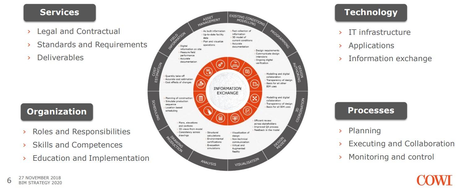
Image 6: BIM in COWI (COWI, 2020).
Image 7: use of GIS according to Theroux, 2020
Image 8: GIS for maintenance (Haskins, 2019)
Hence, It is success fully being implemented. As said by the senior BIM manager COWI is implementing BIM level 3 in its projects (Knott, 2022), it is also been working on Geotech engineering projects (Knott and passe, 2021).
3.2 WHAT DOES GIS DO?
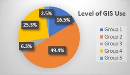
When GIS is helping assets the projects are managed using GIS to collect, process, display, maintain, inspect, and budget data (Zhang et al., 2009). According to a survey on GIS usage with asset management, asset management without GIS (Group 2), asset management with GIS (Group 1), minimal use of GIS (Group 3), and nonusers were classified (Group 4, Group 5)(Theroux, 2020). As seen in the graph from Theroux, 2020, there are more than 50% of individuals that do not use GIS or asset management in their projects. This is an example of BIM and GIS integration in an Ohio State campus building. As you can see in image 8, asset management apps collect and update locations within and outside of an organisation, as well as updated

images of the region, to aid the company when there is a maintenance issue (Haskins, 2019).
3.3 HOW IS IT EXECUTED?
As observed in the business case study, delivering the model georeferenced has been challenging. A BIM model can be loaded into the game engine using the datasmith plugin, however integrating geo-spatial information is more complex. because, BIM data is an information model, whereas GIS data is in the form of shape files that are structured in layers (Çıtıpıtıoğlu, 2017). The two data sets were combined in two ways: by converting the BIM information model to IFC and exporting it as a layer to GIS servers or by adding the model's location information to the BIM information model (Hor et al., 2018). As discussed, GIS world works very different from BIM data base.
As illustrated in the image 9, the workflow of georeferencing the model created in a gaming engine is explained. The workflow shows the importation of a 3D multipatch of a place from a database and the creation of a scene layer that is stored to an internet server (Hor et al., 2018). The online server is stored as an API key including location layer data, and Esri data is imported into a game engine using a suitable plugin (Hor et al., 2018).
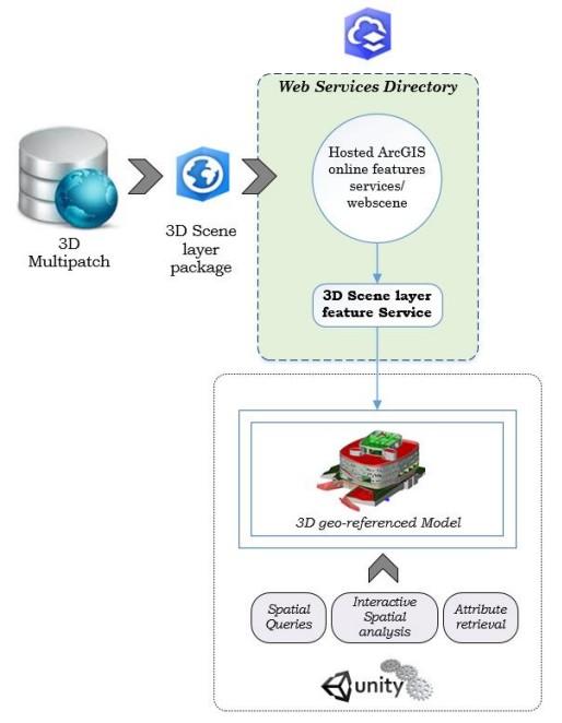
Image 9: Gis information to BIM model workflow (Hor et al., 2018)
3.3.1 Limitations
As previously noted, GIS uses a different data format than BIM, which is causing issues with integration. They encounter data incompatibility, model minimalism, automatic localization, and embedded standards as obstacles (Liu and Zhong, 2021). BIM-GIS integration is


