3 minute read
Drone and Observation Based Mapping


DRONE AND OBSERVATION BASED MAPPING
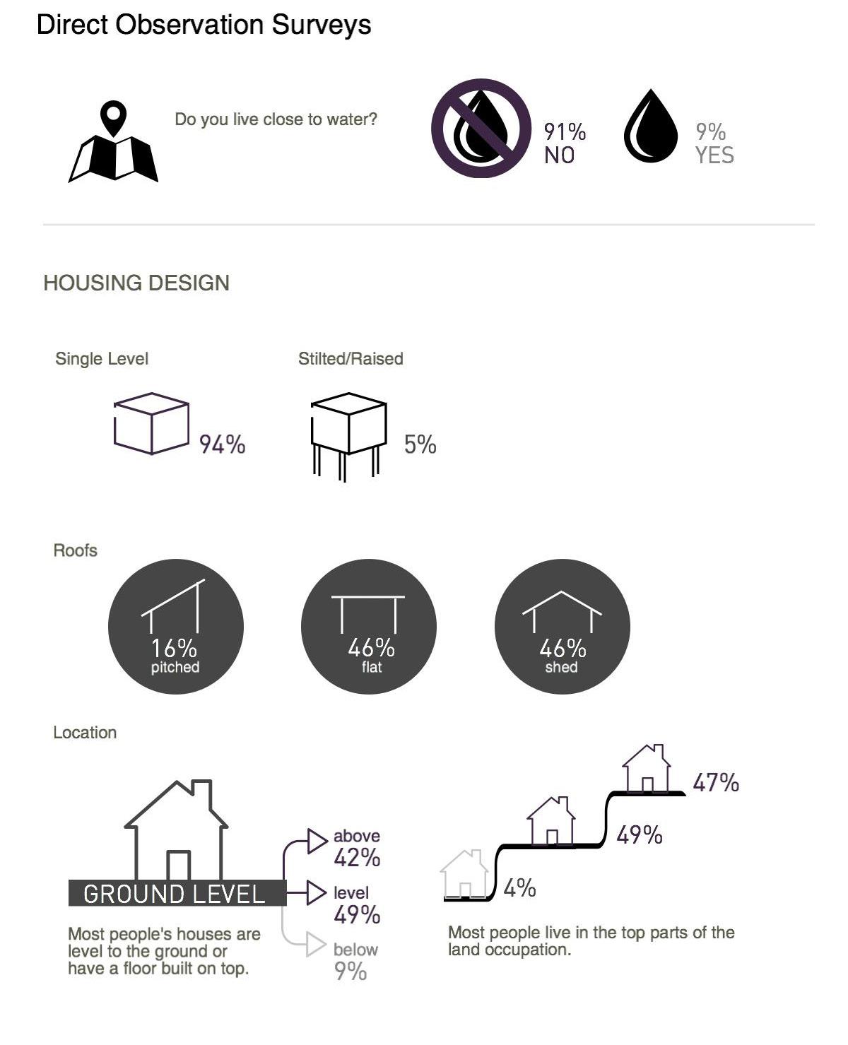
Mapping is an essential methodology for understanding the current conditions of Ocupação Anchieta. In order to produce an accurate base map of Ocupação Anchieta, the Taubman Team hired a drone to photograph the site. The drone images provide information regarding land-use, road networks, dumping sites, building footprints, and natural features. This information is also critical for providing a targeted action plan to address issues of housing, infrastructure, waste management, culture, and the creek and springs.
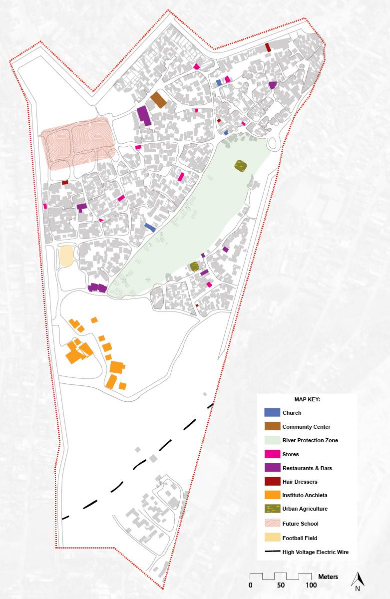
The Taubman Team was able to develop a basic land-use map of the site. While this map is not yet comprehensive, it provides insight as to how residents have developed Ocupação Anchieta. Taubman Team students noted the location of community spaces such as churches, the existing community center, and the location of a future municipal school. The Team mapped the location of commercial development including restaurants, bars, stores, and hairdressers. However, commercial development was challenging to map because there was often no definitive way to distinguish commercial from residential use, especially from the exterior of the structure. Many more commercial establishments exist in the Occupation; however, it was difficult to identify their location given time constraints. Lastly, the Taubman Team mapped more natural land uses including the area surrounding the creek and small areas of urban agriculture.
61 Drone Equipment.
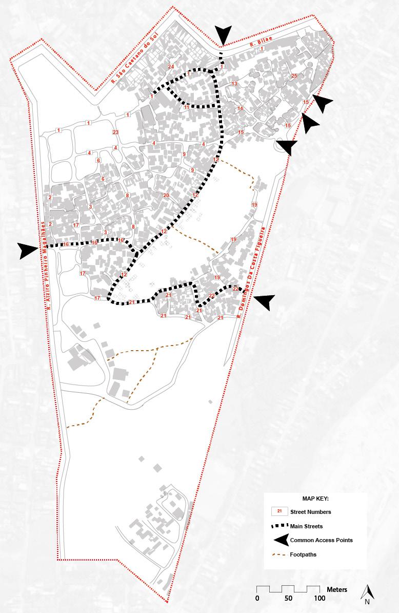
The street network and circulation was mapped mostly through drone imagery, direct observation, and informal interviews. The Occupation’s street networks are named using block numbers. The numbering system is not straightforward as some block numbers extend for several blocks and have kinks or turns. This ambiguity made mapping and conversations about block numbers essential. Moreover, the Taubman Team also observed which streets and entrances residents most frequently use.
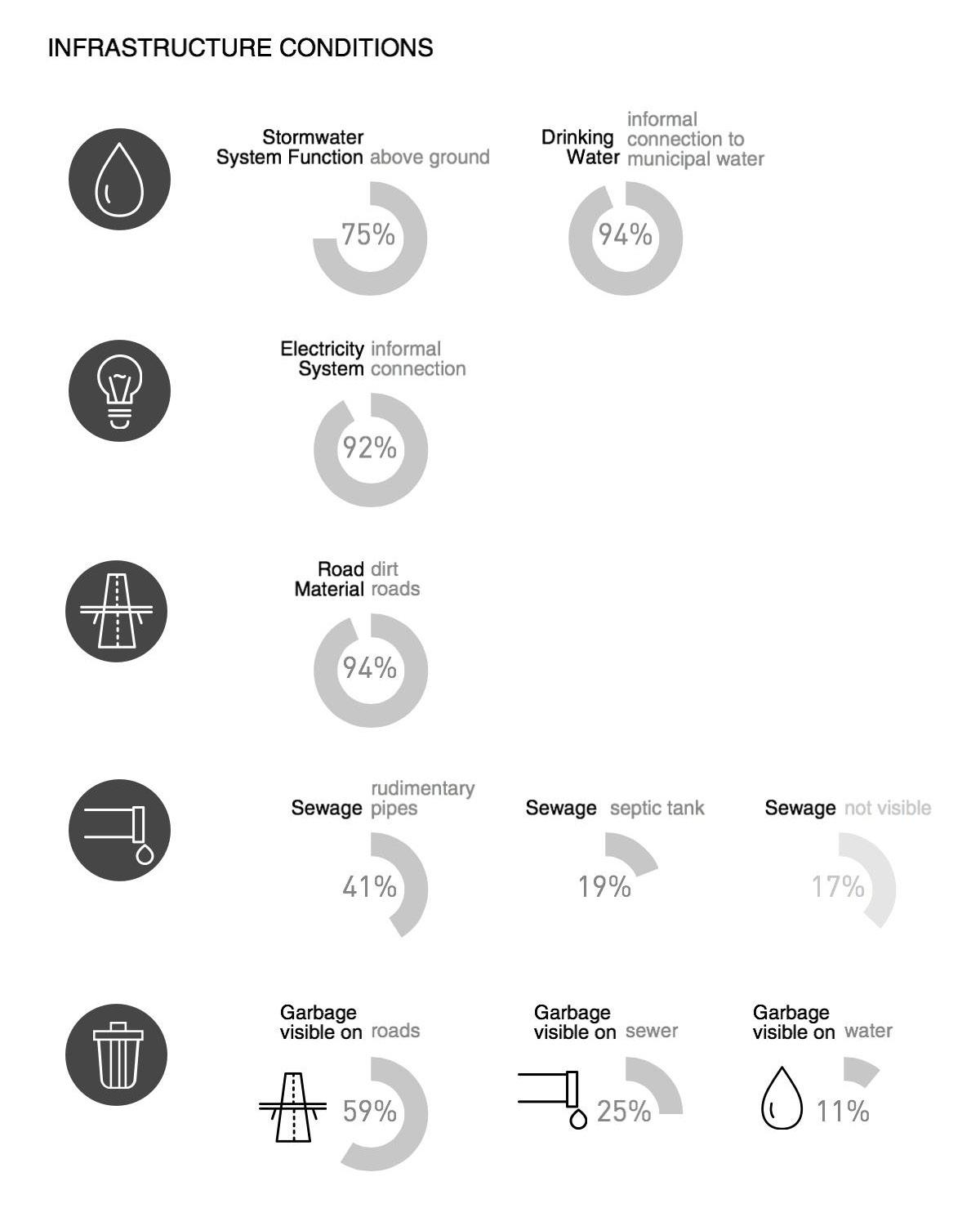
Waste was a critical component to map. Students mapped the location of formal, municipally placed dumpsters along the main, paved external roads of the Occupation using iPhone geolocation. The Team identified one main recycling area through direct observation (managed by at least one resident). Through a combination of direct observation and iPhone geolocation, the Taubman Team classified some of the dumping areas around the site as high or low density. This classification, however, was not formal but rather a qualitative judgment regarding the concentration of waste within the Occupation. The Team also notated where housing foundations still remained after the TETO-facilitated demolition and relocation of housing structures around the creek. Lastly, iPhone geolocation allowed for the small areas destroyed by fire to be identified.
Lastly, Taubman Team students used drone imagery to map the natural features of the site. This was extremely useful in understanding the extent of the tree canopy and informative for understanding where potential interventions could occur. Taubman College students also used direct observation and water testing to understand the location of the springs and the creek. While the Team struggled to exactly pinpoint the locations of all the springs, direct observations and interviews provided a decent estimation. Furthermore drone based mapping made the creek flow location clear, however this could vary depending on season and rainfall.
In combination with direct observation, the Taubman Team used iPhone geolocation and drone imagery to understand the above conditions. The interviews with our client and partners reveal that density is perceived as a problem for achieving ecosystem recovery at the creek area and environmental protection elsewhere. Residents fear that any upgrading or housing development proposal may require relocation of their homes to make room for roads, infrastructure, and open space. The Association asked the Taubman Team to develop proposals that fit at least 600 houses within the boundaries of Ocupação Anchieta. Thus, it was crucial to develop a more precise map in order to craft the action plan, especially pertaining to waste management, housing, and infrastructure. Hopefully, upon returning to the site, members of the team will be able to confirm and expand upon these maps to make them a more accurate and valid tool for the community and researchers alike.
62 Land Use.
63 Street Network and Circulation.
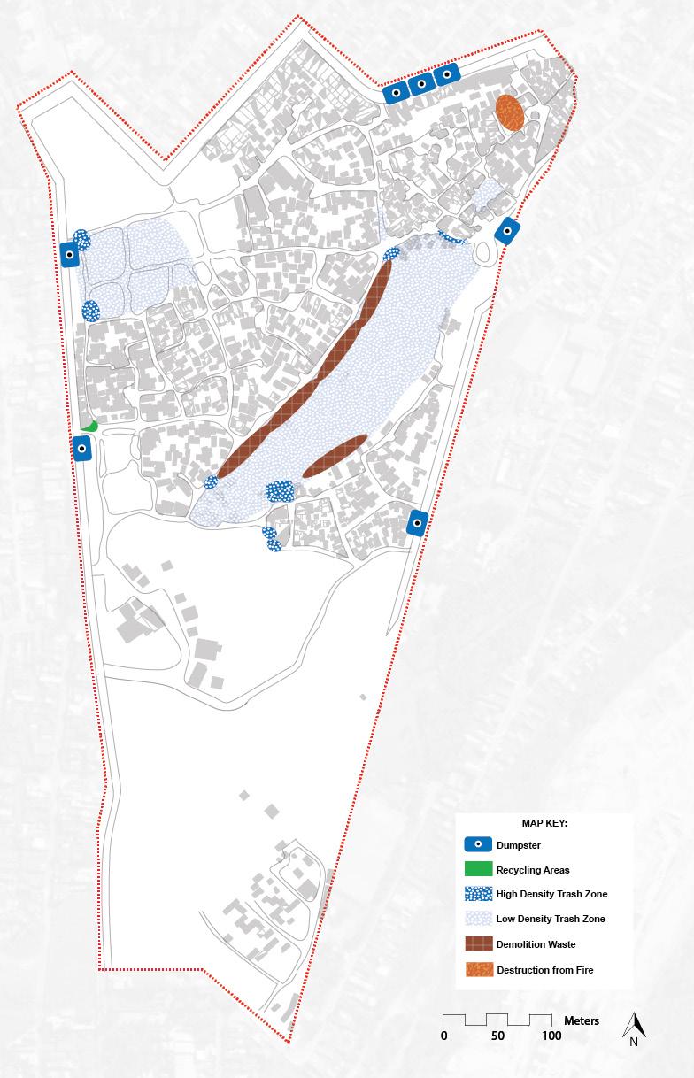
64 Waste.
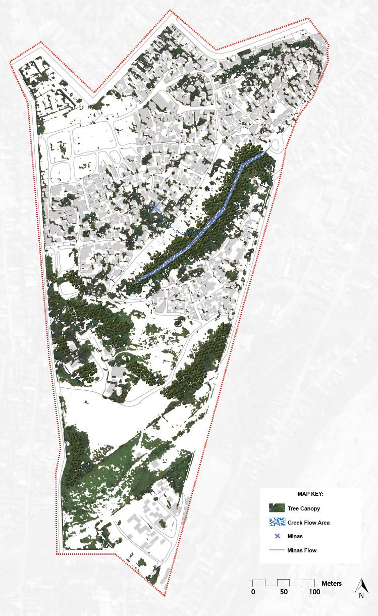
65 Natural Features.