AMANDA DIAS BASTOS

Adobe CC Suite
ArcGIS Pro
Figma
G-Suite
Keynote
Microsoft Office
Pages
SketchUp Pro
CERTIFICATION
Google UX Design Professional Certificate
LANGUAGES
Portuguese — expert
Spanish — intermediate
Urban Designer
Code Studio | Austin, TX | 2021 - 2023
Graduate Assistant
DAAP Library | University of Cincinnati | 2019 - 2020
Development Services Intern
Hamilton County Planning + Development | Cincinnati, OH | 2019
Senior Library Services Assistant
TechCenter + MakerSpace | Public Library of Cincinnati + Hamilton County | 2018
Classroom Teacher
Academy of Multilingual Immersion Studies | Cincinnati, OH | 2016 - 2017
EDUCATION
Master of Community Planning
University of Cincinnati | Class of 2020
B.S. in City + Regional Planning
The Ohio State University | Class of 2016
AWARDS
Director’s Choice DAAPcares Award
Food Access | 2020
Outstanding Student Project of the Year
The POD at Riverside North | 2015
Academic Excellence in Creative Nonfiction
Full Circle | 2015
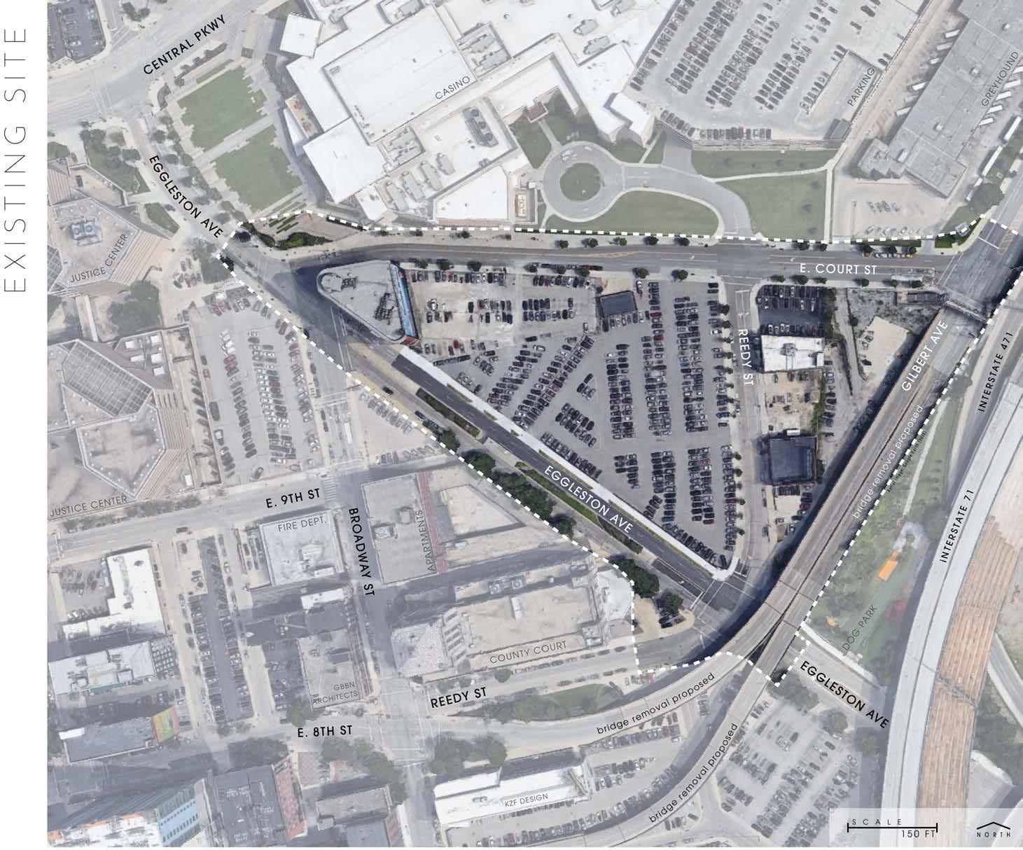
Honolulu Land Use Ordinance | HI
Project Manager and Lead
2021 - 2022 | Work Sample
Detroit Zoning Code | MI
Contributor – Analysis & Graphics
2021 - 2023 | Project Website
Lynnwood Title 21 | WA
Project Manager and Document Production
2022 - 2023
Merriman Valley Master Plan | OH
Contributor – Analysis, Mapping & Writing
2021 - 2022 | Adopted Plan
Los Angeles Zoning Code | CA
Contributor – Analysis & Graphics
2021 - 2023 | Adopted Code
Pomona Zoning Code | CA
Contributor – Analysis & Graphics
2022 | Adopted Code
CrossWaters East Master Plan | TX
Contributor – Analysis & Graphics
2021 - 2022 | Work Sample
San Antonio UDC | TX
Contributor – Graphics & Code
2022 | Posters | TOD Districts
Sammamish UDO | WA
Contributor – Document Production
2021 | Adopted Code
Najran Urban Code | Saudi Arabia
Contributor – Graphics
2022 - 2023 | Draft Code
Cleveland Form-Based Code | OH
Contributor – Graphics
2021 - 2023 | Adopted Code
Greenville Development Code | SC
Contributor – Graphics
2022 - 2023 | Adopted Code
Houston Development Regulations | TX
Contributor – Graphics
2022 | Work Sample
Redmond Zoning Code Update | WA
Contributor – Graphics
2023 | Proposal


BRIEF
Unlike traditional zoning where a single district applies to a broad area, zone strings offer a modular approach. The development standards of Euclidean zoning are split into categories, then strung together in unique combinations to create a zone string. This allows more flexibility for zoning to focus on function and user experience rather than the regulation of land use. Various zone strings are applied throughout a city to accommodate a range of user needs.
In Najran, the zone strings include a Form District, a Frontage District, and a Use District. The Form District ensures that building forms are compatible with their context. The Frontage District guarantees the built environment supports the vitality of the public realm. The Use District regulates the activities on each lot.
March 2023
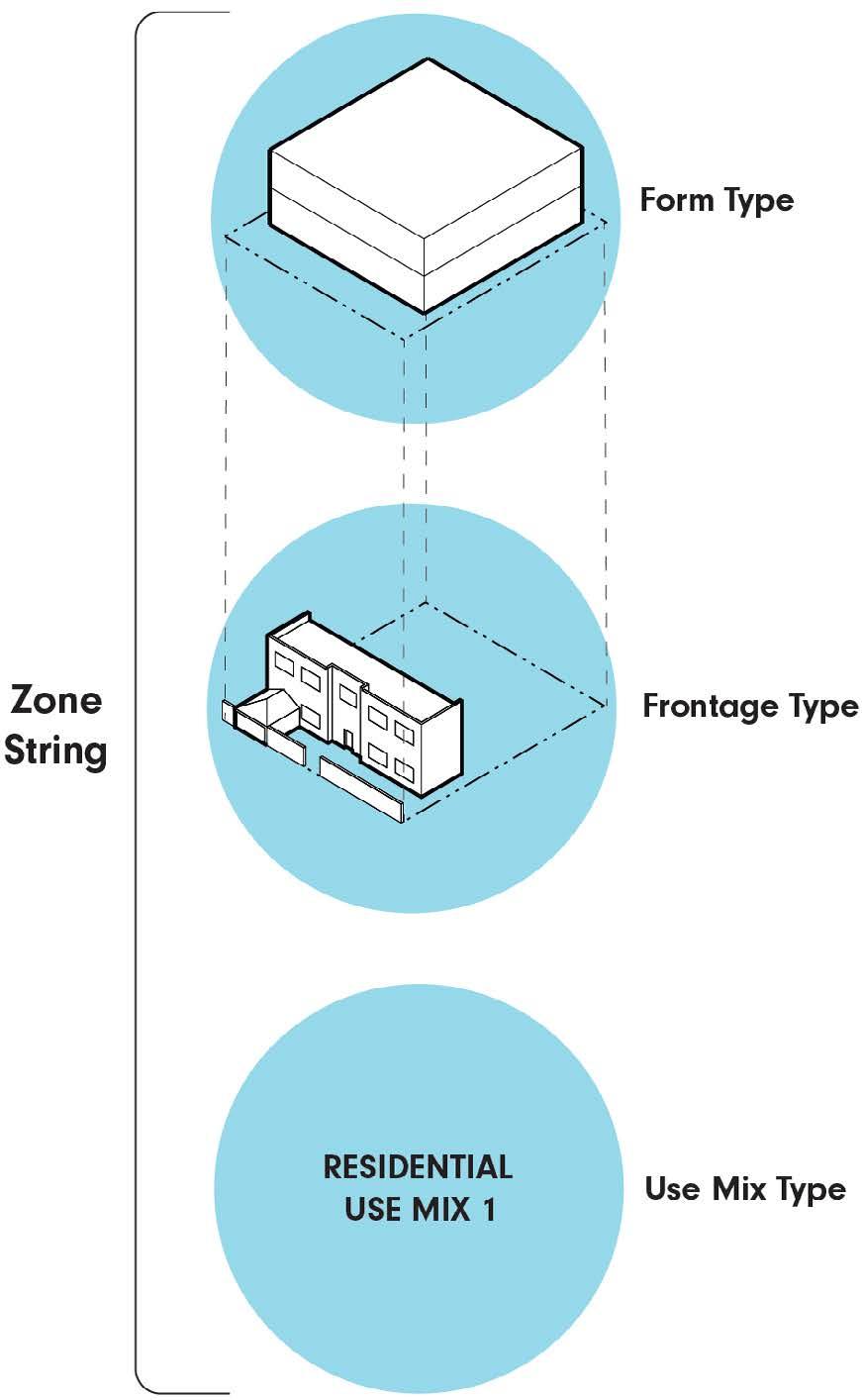
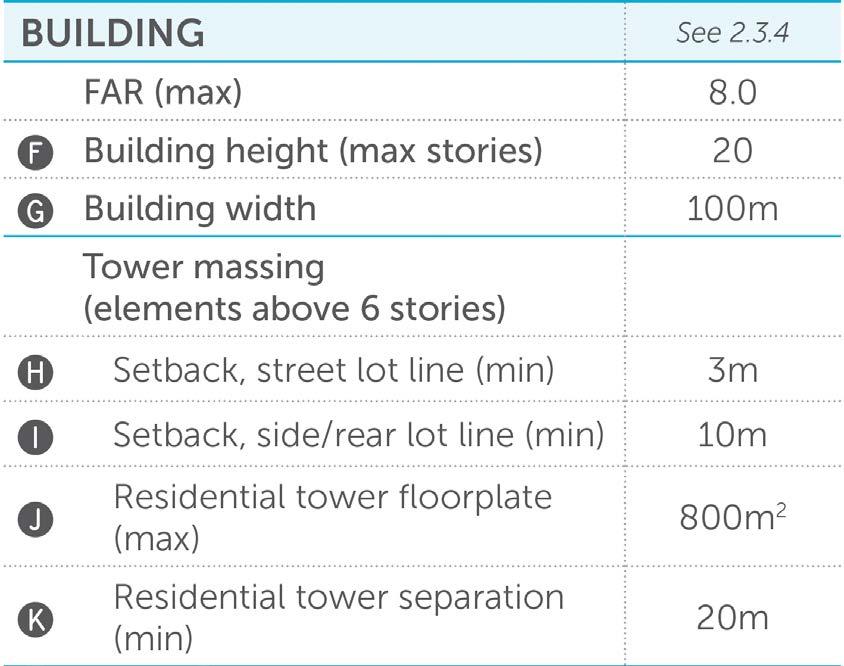
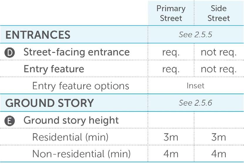
Form Districts refer to building massing and placement on a site. They regulate lot sizes, lot widths, setbacks, building heights, and building widths.
Setbacks determine how close a building is to the street. Pulling buildings up to the street creates a consistent ‘street wall’ that frames and defines the public realm. Users feel oriented, engaged, and safe when they can look down the street and clearly see the area that belongs to them.
When setbacks are deep, there are often parking lots between the building facade and the street, and the sidewalk is riddled with curb cuts. This widens the public realm beyond the human field of vision, leaving the user feeling aimless, disoriented, and at the mercy of vehicular traffic.
High-Rise Wide (HR-W) District
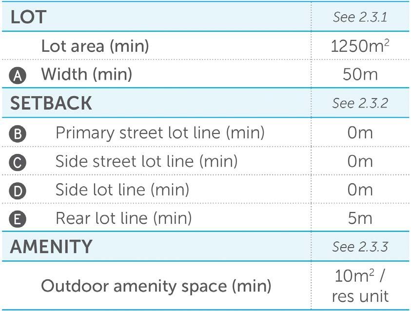
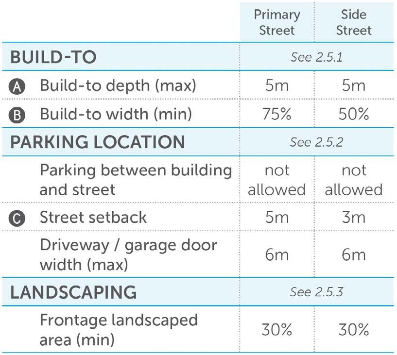
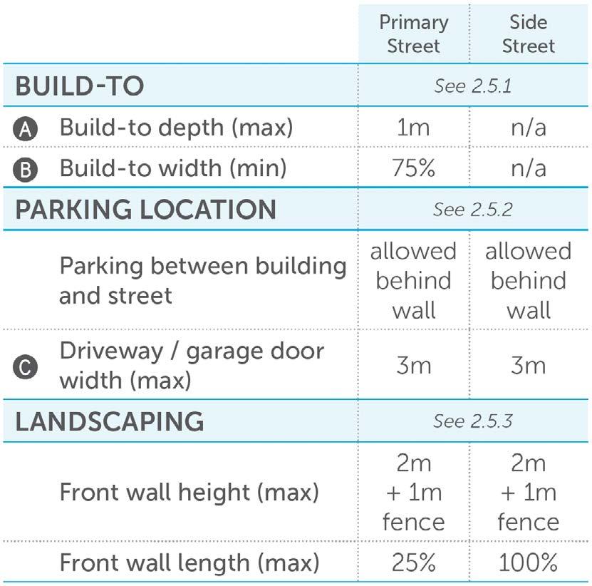
Frontage types refer to the appearance of the street-facing side of a building. They regulate build-to lines, parking location, transparency, entrances, ground story height and elevation, and front walls.
Build-to is measured in width and depth. The build-to depth is an extension of the setback regulated by the Form District. The build-to width is measured as a percentage of the lot width that must be occupied by the building. The higher the percentage, the less likely it is that public spaces that belong to people will belong to cars. Also, since parking and vehicular access is relegated to the rear, high build-to widths often result in shorter block lengths and alley networks, thereby improving walkability and enhancing the pedestrian experience.
Site Front Design General (G) District
Street-Facing Facade
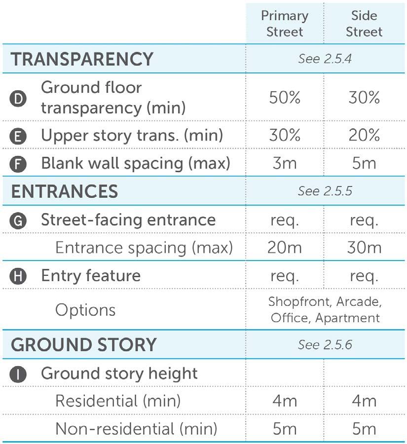
Transparency requirements provide visual interest and encourage connections between the street and building interiors. When people can see activities occurring within buildings they are more likely to engage in those activities. Ever passed by a new store with an attractive window display and decided to go inside? That’s the transparency requirement at work.
Transparency has another benefit: it improves public safety. As the urbanist Jane Jacobs said, transparency allows for “eyes on the street”, meaning people feel safer on the street when they know someone else can see them. The bigger the windows on the ground floor, the safer the city.
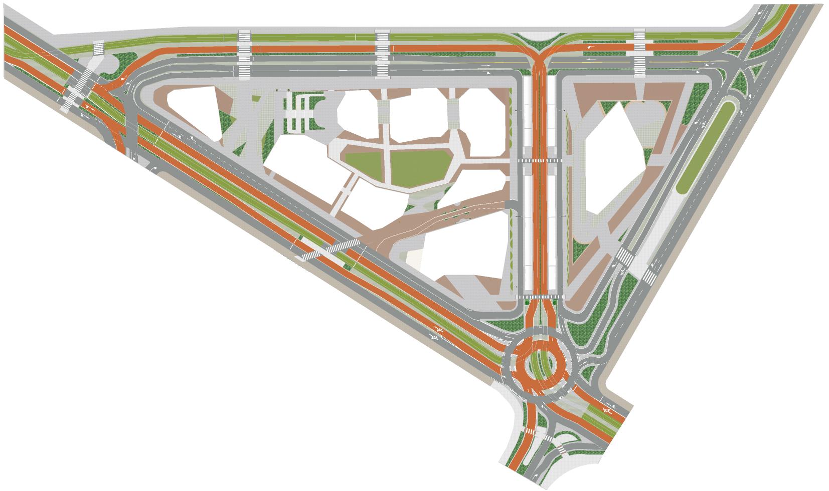
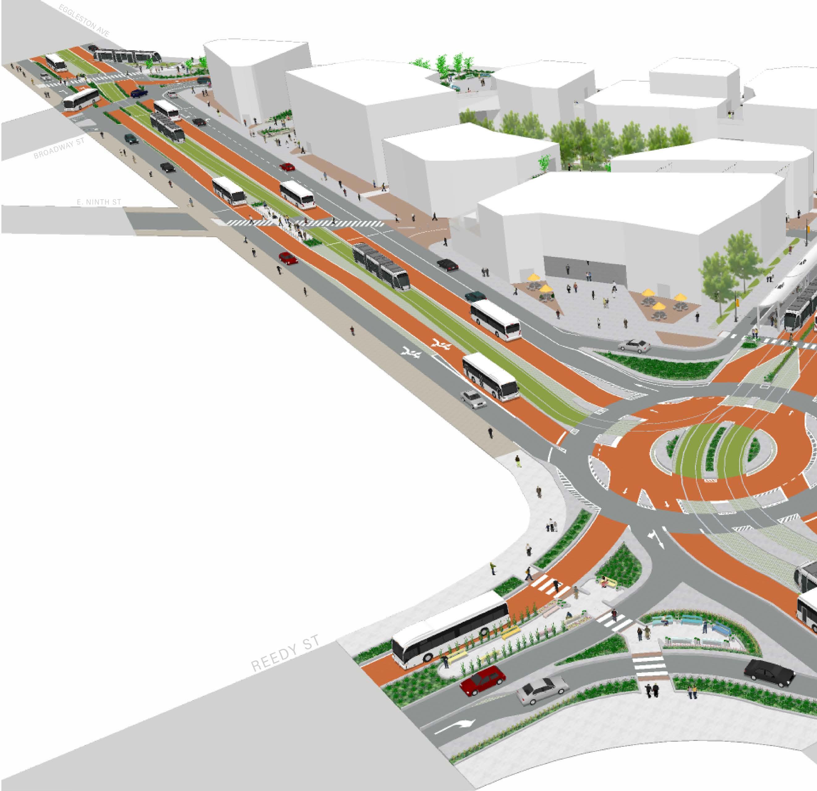
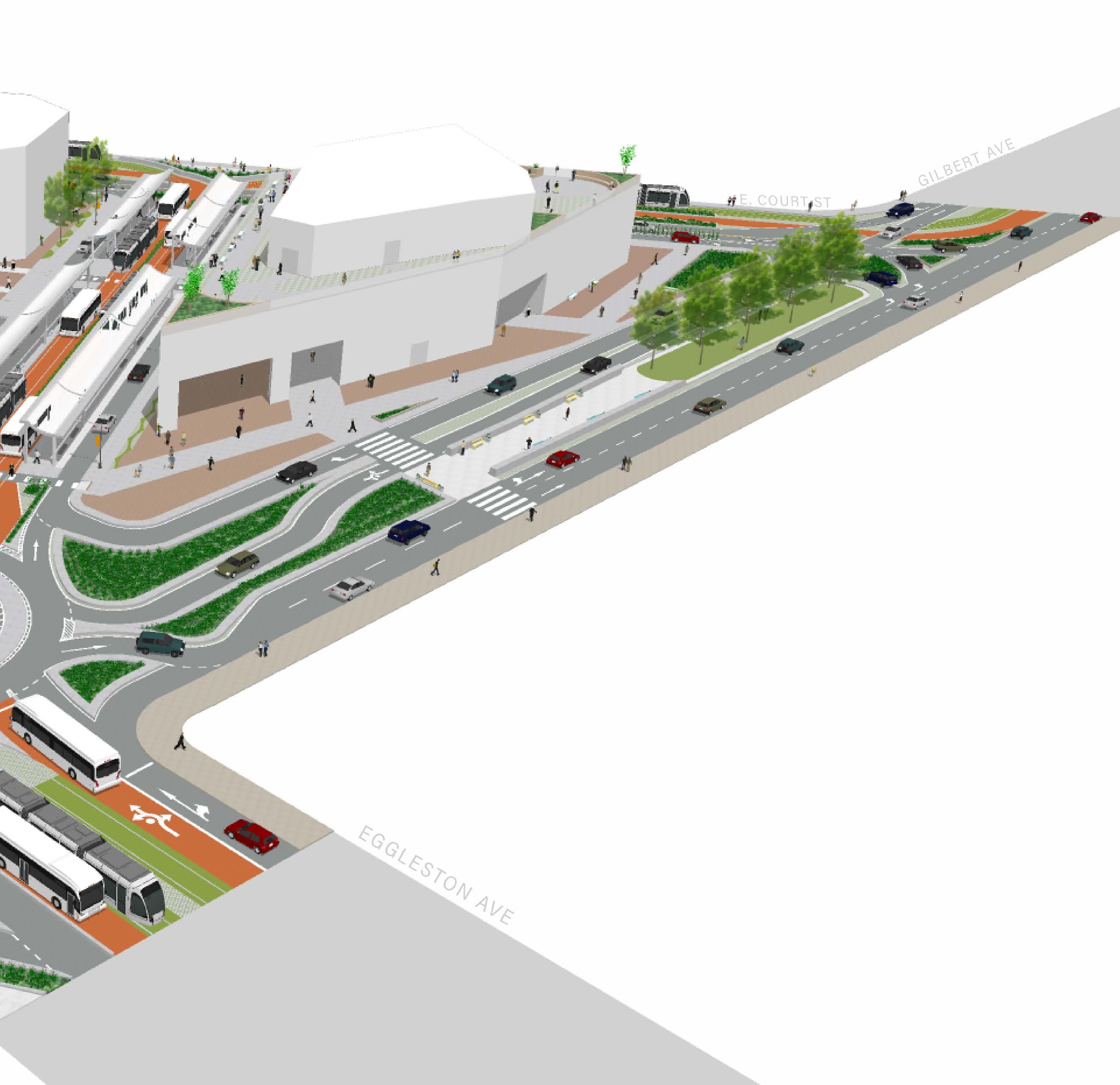
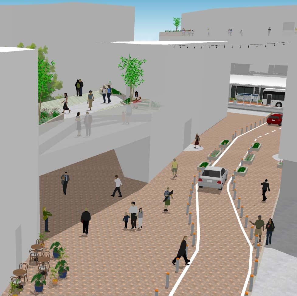
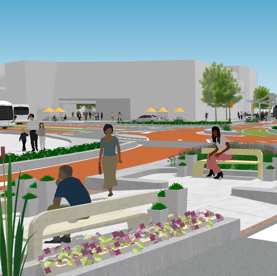
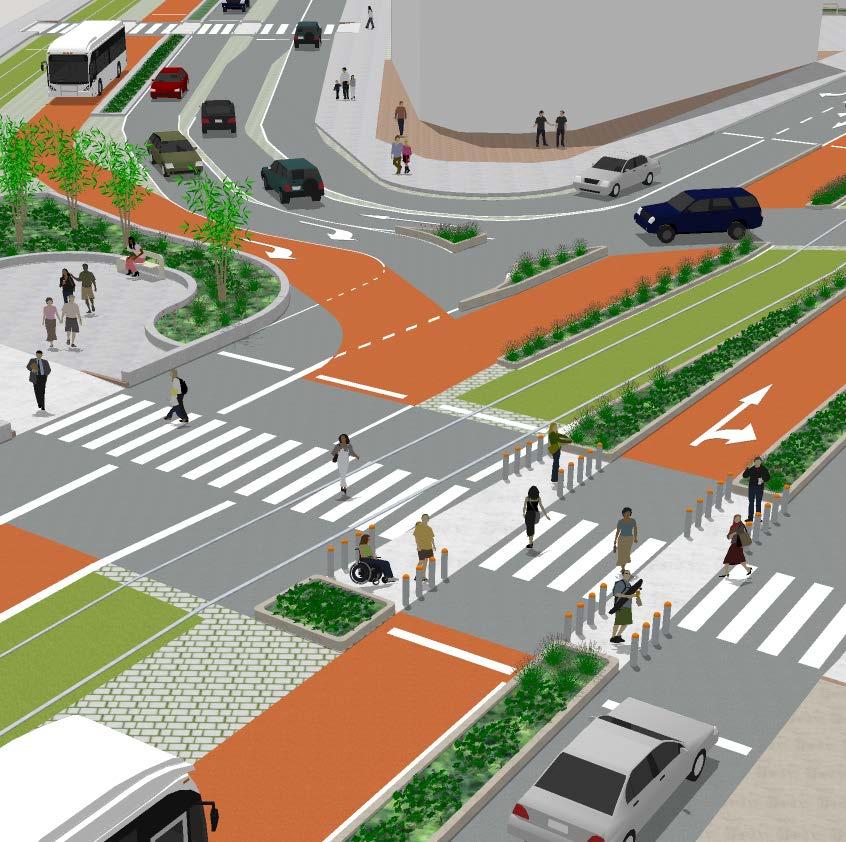
This project began with a vision of Downtown Cincinnati with 50% less parking and a development plan to replace lots, garages, and curbside spaces. A city with less parking infrastructure is a city that can be more Public, Social, Mobile, and Green.
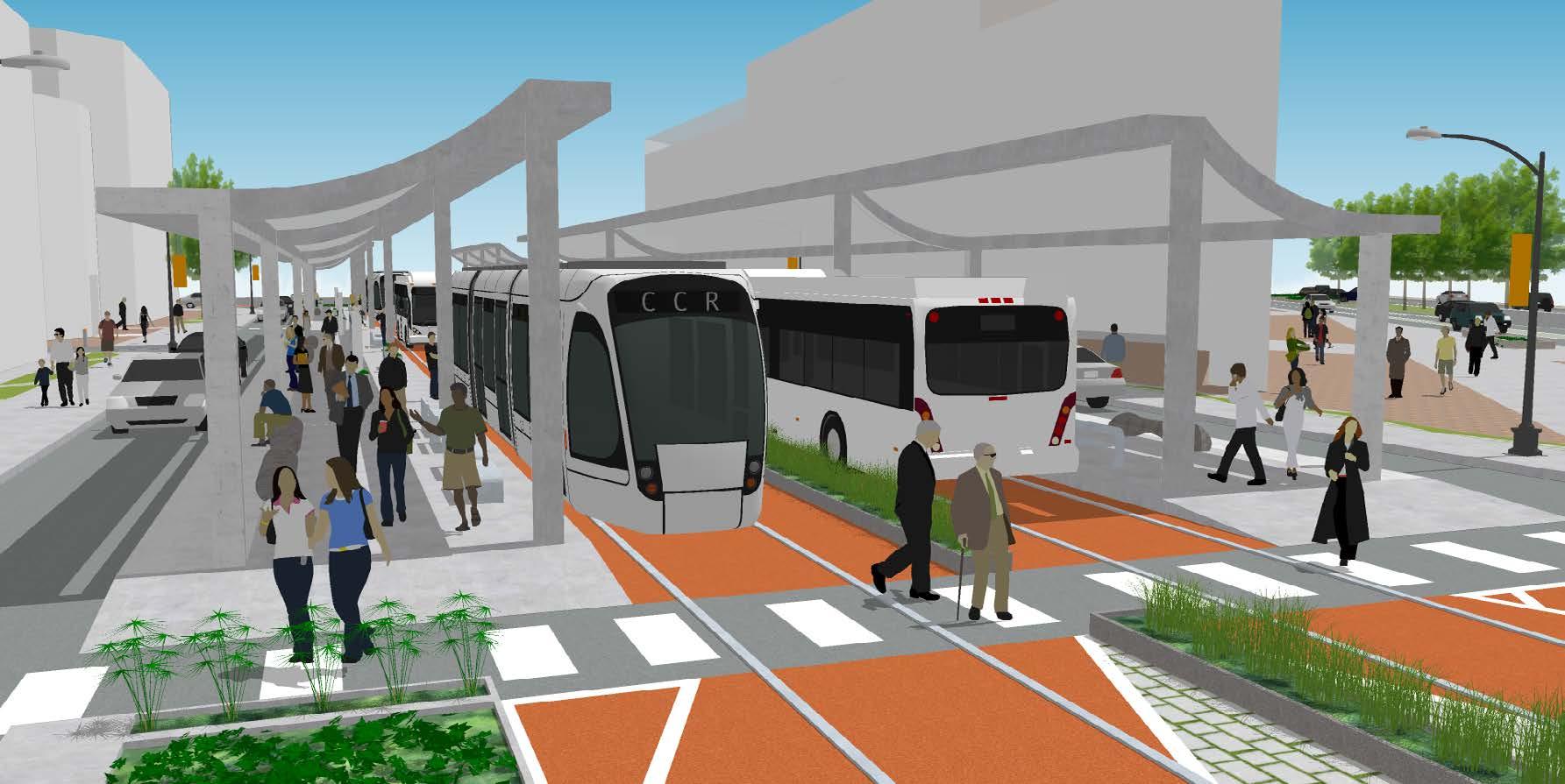
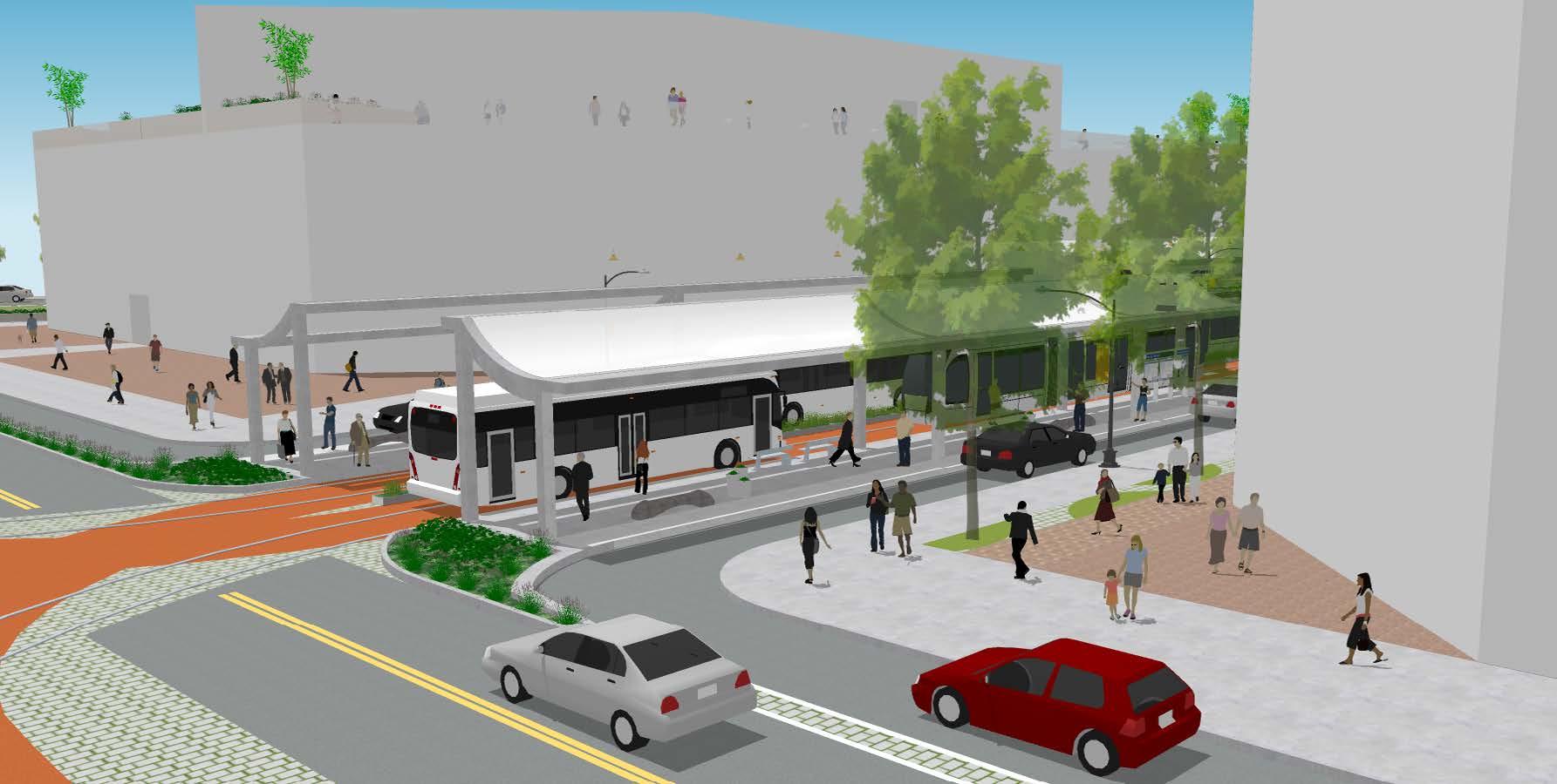
Given the projected demand for multimodal transportation, the plan’s Downtown Mobility Strategy ( right ) proposes protected two-way cycle tracks, Bus Rapid Transit lanes, the creation of the Cincinnati Commuter Rail network, and the construction of a public transit hub—Queen City Station—that serves as a gateway into the Downtown. This project aims to unite people by creating a place that values social responsibility, communal fortitude, and individual worth and integrity.
COURSE MCP Plan-Making Workshop: The Future of Parking
August 2019
Project Lead


This project seeks to actualize the full potential of Downtown Cincinnati by transforming it into a desirable, flexible, synergistic, and people-oriented place for everyone. The project will achieve this vision by incorporating the Four Dimensions ( right ) in all new developments and activations of former parking lots and garages. One of these locations is the chosen site for the new Queen City Station. Tucked between several major corridors in an underserved area, it is perfect for a transit hub and human-oriented development.
Four Dimensions
Goals for New Development
Public
Prioritizes equity, inclusivity, and civic pride by building landmark public centers and affordable housing.
Social
Prioritizes quality of life, social capital, and vibrancy through arts + culture and community gathering.
Prioritizes connectivity, flexibility, and walkability with complete streets and new multi-modal networks. Mobile
Green
Prioritizes the environmental resilience and sustainability with green infrastructure and renewable energy.


The Director’s Choice DAAPcares Award honors outstanding capstone projects that identify humanitarian issues and apply exceptional skill, knowledge, and creativity to improve quality of life.
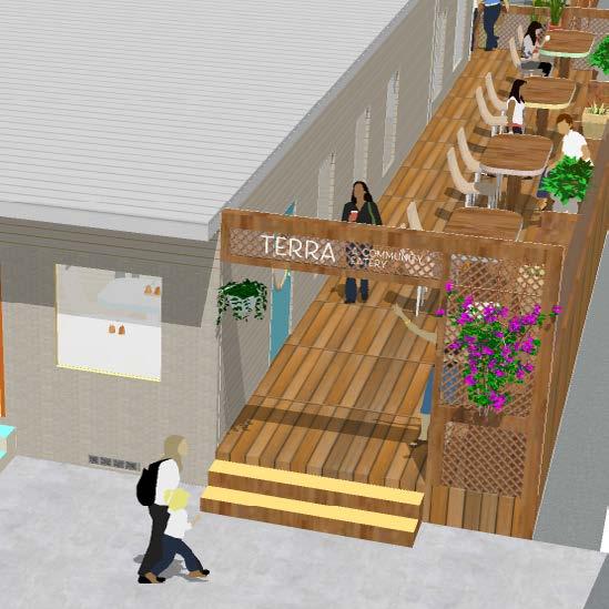
This project addresses food access and the complex issues surrounding it in Price Hill, Cincinnati. According to a 2017 study,1 four out of every ten neighborhood residents experience food insecurity.
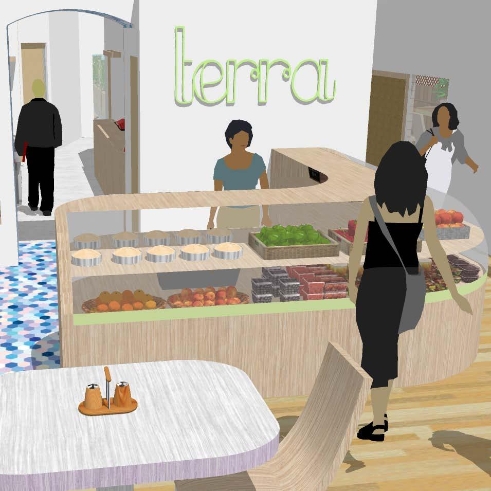
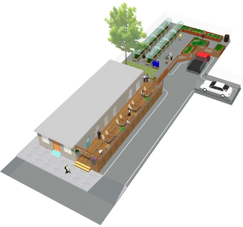
The Guide to Food Access facilitates community planning efforts to implement effective food access solutions. It provides a step-by-step plan using mapping, surveys, and local knowledge to identify the best solution. For Price Hill, that solution is Terra: A Community Eatery.
Health, 2017.
April 2020
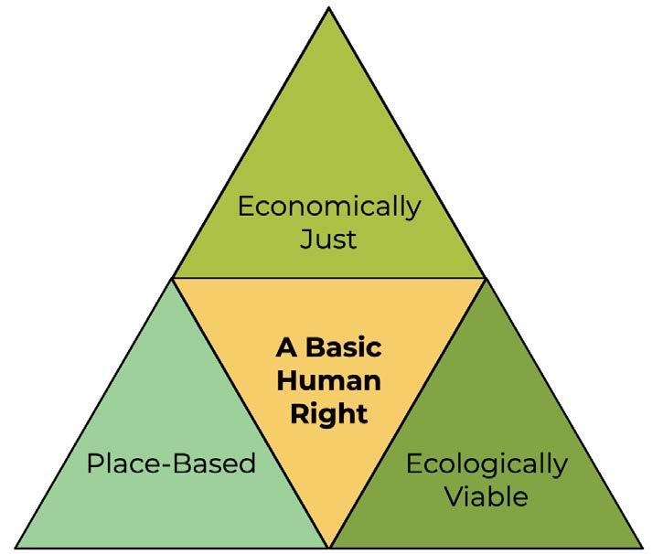
Any system operating under the assumption that food is a privilege is inhumane. All people depend on food for survival.
Food is not a privilege to be reserved only for those who can afford it.
PLACE - BASED
Food cannot be separated from culture, and both are important for community wellbeing. All cultures of a place are to be represented and celebrated.
Food systems must support the health of the land base so that it can continue to supply nutritious food.
Analyze your community’s food system:
Food to Take Home Food Away from Home Grocery Stores
+ Gardens
+ Other Use analysis results to create the Existing Food Access Map
Asses your community’s social needs Use results to create the Services Needed Map
Job Training Youth/Elderly Centers
Food Education Food Bank/Pantry
Identify areas that would most benefit from walkable food access. Consider:
Population Density No-Car Households
Commercial Districts
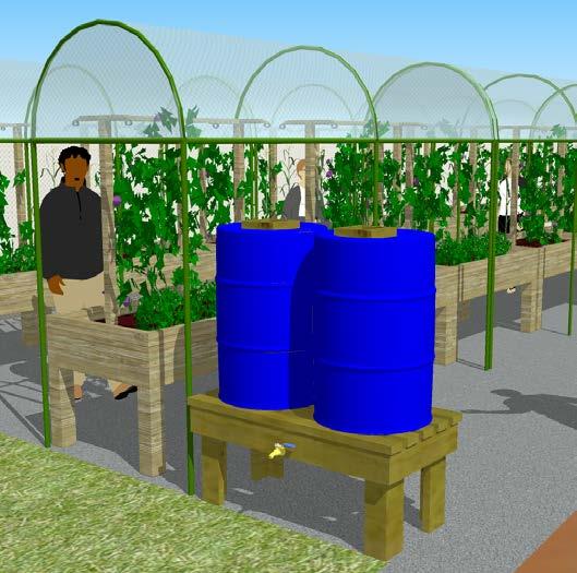
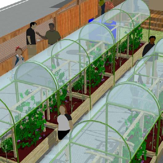
Determine potential for urban farming and community gardens. Consider:
Slope + Soils Sun Exposure Water
Walkability Map and
Create the Maximizing compare with the Existing Food Access Map. Use results to create the Outdoor Site Feasibility Map.
Identify gaps in representation and prioritize filling them. Consider:
Local Ownership Cultures Represented
Abilities + Identities
Identify partnerships and management:
Partner to Provide Space
Partner to Operate Project
Partner to Fund Development
Create the Place-Based Map compare with the Services Needed Map and the and Maximizing Walkability Map.
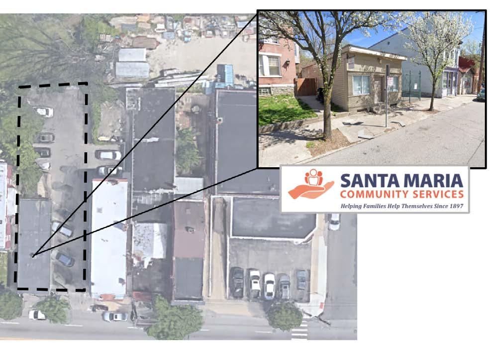
The building on the site is a one-story facility owned by Santa Maria Community Services, a highly supportive project partner. Currently, the site is an office and community gathering space. A large parking lot wraps around two sides of the building, and a single tree occupies a small patch of grass in the backyard. This property is ideal for the site proposal because it is located centrally, owned by a community-driven organization, and sized for highly impactful small-scale development. Site conditions are also optimal for gardening as it has the appropriate sun exposure, windshield, and water catchment.
The Guide to Food Access results reveal Price Hill is a food swamp. Plenty of food options are available, but few are healthy or nutritious. Drive-thrus and diners dominate the food supply, and there is only one grocery store in a four-mile radius. Price Hill urgently needs fresh produce, healthy food options, and grab-and-go establishments.
In addition to offering fast-casual dining, the proposed development at the selected site will address several of the neighborhood’s social needs by providing culinary classes, after-school programs, gardening workshops, business seminars, job training, skill-building, and more.
December 2018 BRIEF
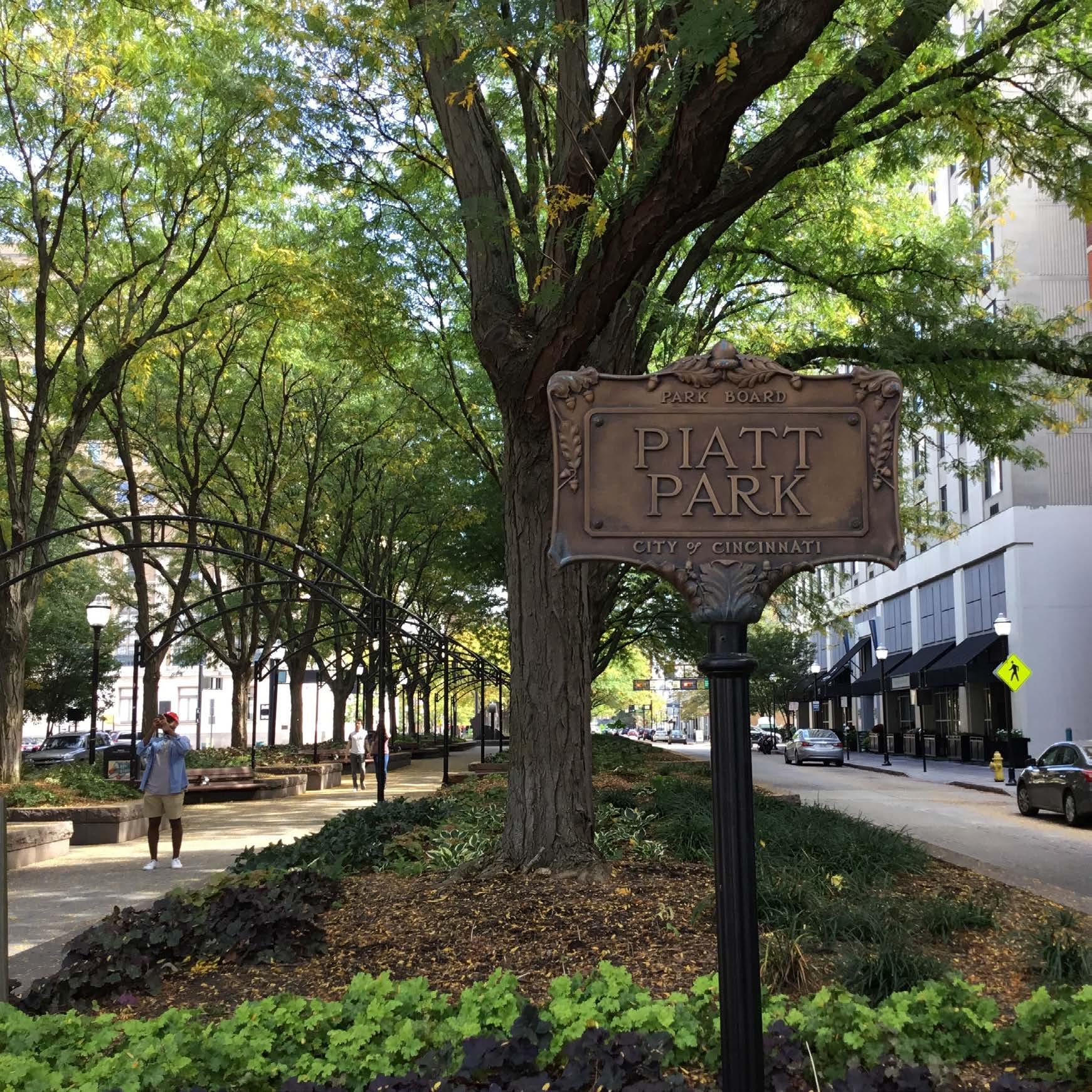
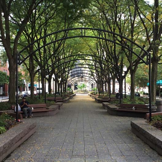
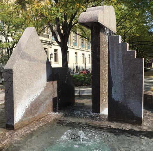
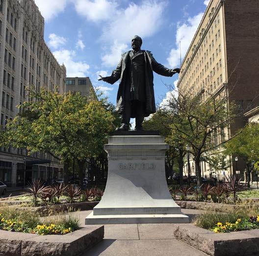
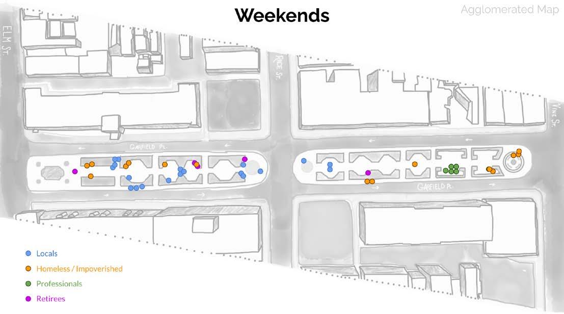
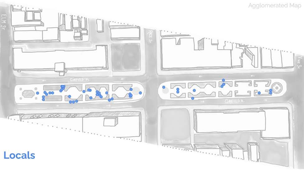
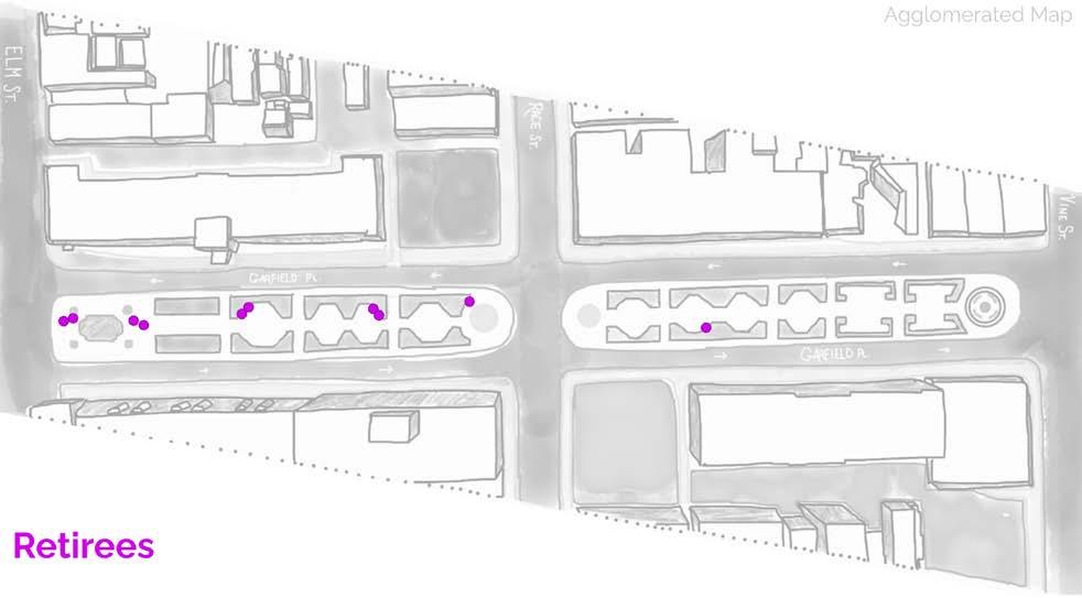
Good public space is responsive, democratic, and meaningful. As a site of daily collective action, social response, and ritualized behaviors, Piatt Park qualifies as a good public space. It is a tree-lined escape from the bustle of Downtown Cincinnati. It has held markets, art and culinary festivals, peaceful protests, and other community gatherings. It elevates the status of the civic with its grand trees, gardens, presidential statues, reflecting pools, and sculptures by local artists. Piatt Park is a site of remarkable urban design and rich history in a dense, narrow space.
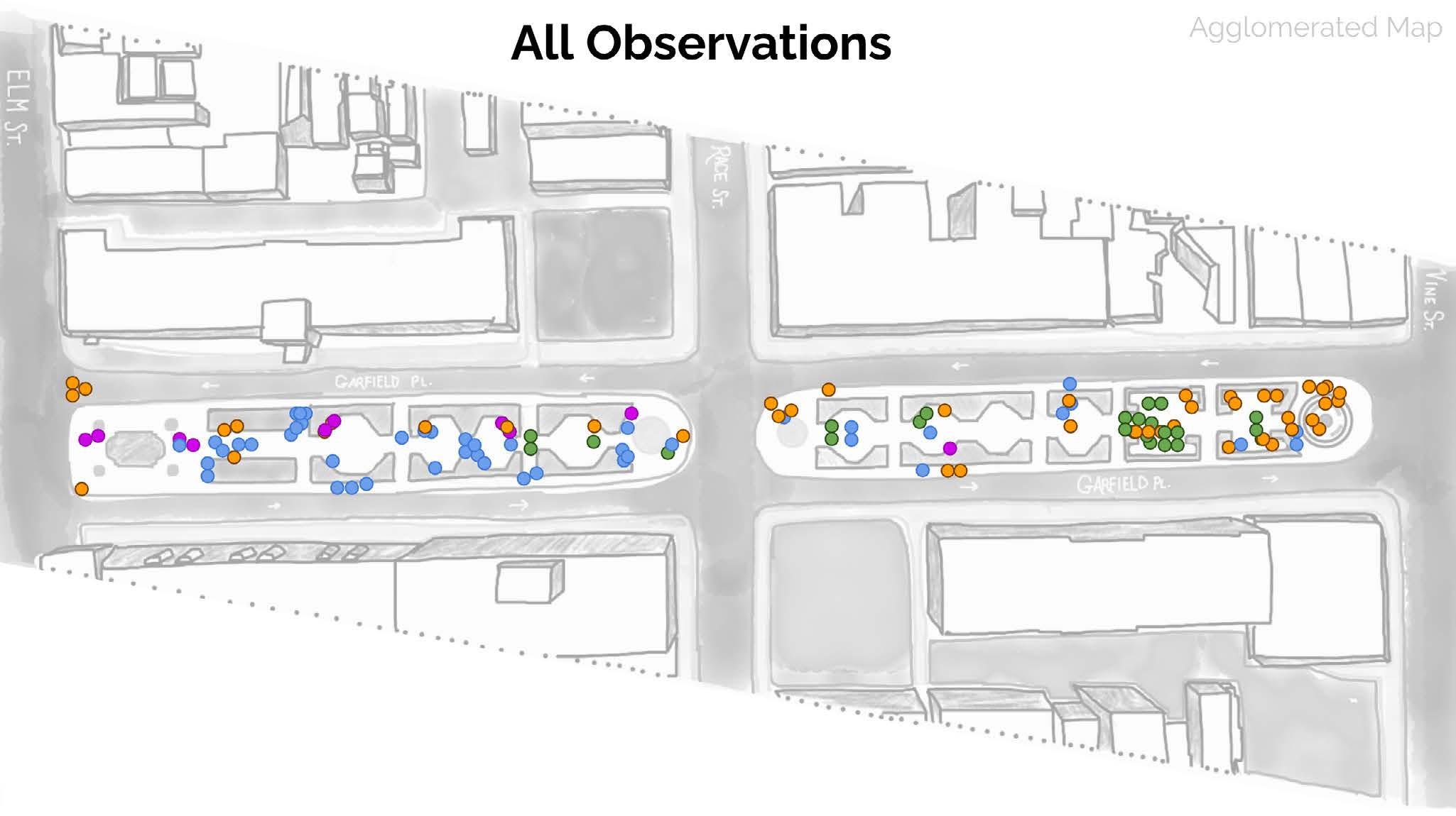
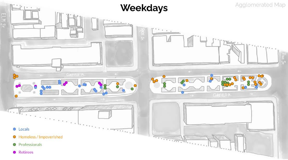
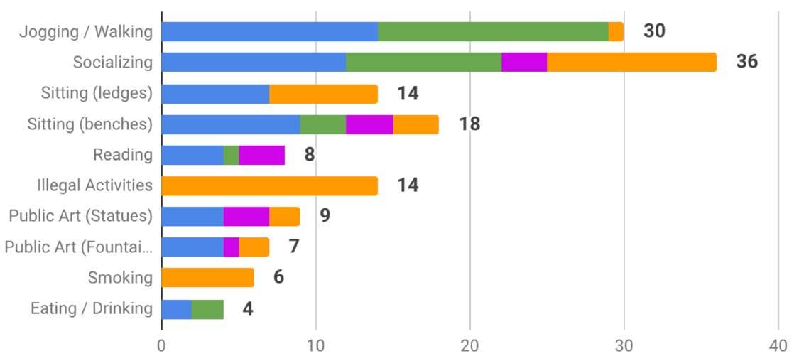
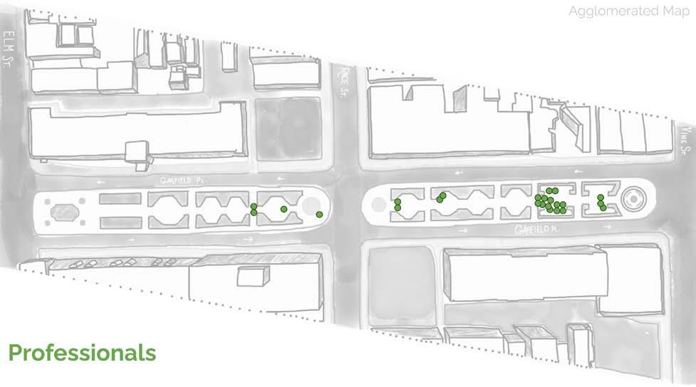
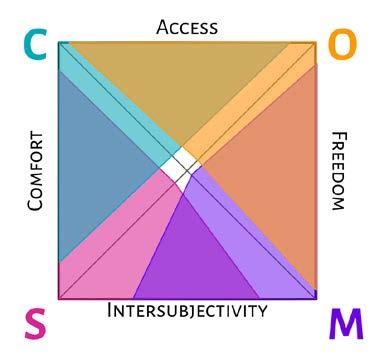
This course had us conduct a user analysis of public space over four months with no less than fourteen site visits. The results of these observations informed our assessment of whether the public space qualifies as “good public space” based on an analysis model of our creation (Carr, Francis, Rivlin, Stone).
MCP Public Space: Possibilities + Potentialities
Individual Project
Weekdays
Weekends
User Profiles
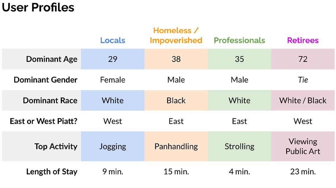
Locals Unhoused Professionals Retirees
Locals
BIPOC White / BIPOC
Retirees
Observed Activities
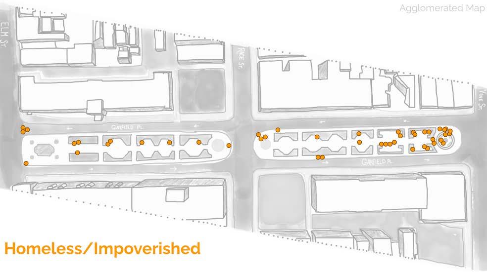
Unhoused Professionals
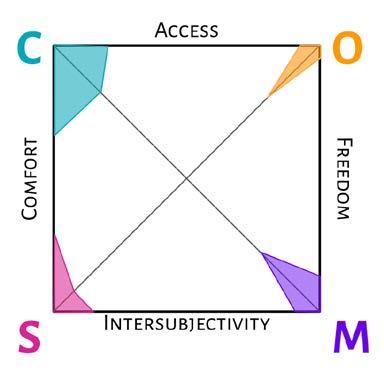
Users respect others within the space. Fear + anxiety are not present. All users are treated as equals.
Space is inclusive of all people, regardless of identity, status, or ability.
isthedegreetowhichambienceanduser behaviorcreateademocraticandrespectful environment.

Conviviality is evident. All users coexist successfully. Spatial design supports many forms of interaction.
Space does not legally or visibly exclude individuals or groups.
ownedisthedegreetowhichthespaceispublicly+operated,accessibletothepublic,and usedfreelybythepublic.
Users feel free to use the space however they wish. Activities and preferences are not limited.
FREEDOM
isthedegreetowhichthepeopleperceivethe spaceassignificant,showrespecttothespace, andviewthespaceaspublic. informationalisthedegreetowhichthepublicspaceallowsfor andexchange,personaldevelopment, sociallearning.
Users interact with strangers. Difference is diminished through interaction.
INTERSUBJECTIVITY
This model measures the observed qualities of Piatt Park to assess whether it qualifies as good public space.
Significance is flexible and personal. Public chooses to respect the space and honor it.
Space is welcoming and inclusive of new users. Users see familiar faces. Space is part of personal routines.
INTERSUBJECTIVITY
FREEDOM
2.5 of 4 criteria met
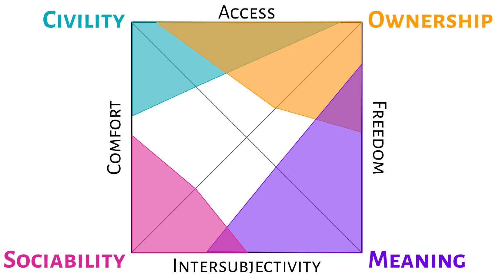
2 of 4 criteria met
1.5 of 3 criteria met
Good Public Space
4 of 5 criteria met
Bad Public Space