PREFACE
Winston Churchill famously observed, “we shape our buildings; thereafter buildings shape us.” With only slight modification, that pronouncement could apply equally to the influence of topography as the foundation for all landscape architecture. We shape the land; thereafter, it shapes how we live upon it. Transforming the earth is the primary act in realizing any landscape design— whether an act minimal or momentous, whether applied to unspoiled natural terrain or a polluted brownfield. It provides the base and basis for all subsequent planting and paving; it is the ground from which all buildings rise. Most commonly, the acts of digging, piling, and reshaping first address issues of function and performance. At other moments, however, the earth is altered for purely aesthetic reasons, at an extreme making sculpture of the land. In real estate, it is said that the three most important factors are “location, location, location.” That adage applies in equal measure to the reconfiguring of the earth, as on location depend soil composition, its stability and fertility, and the vegetation that thrives there.
Held at the University of California, Berkeley, in March 2020, the symposium The Shape of the Land: Aesthetics and Utility gathered a select group of twelve landscape architects and historians hailing from eight countries, who presented their thoughts on the place of topography in their own work and in the works of others, both contemporary and historical. The range of scales represented by these projects was staggering, spanning the intimacy of backyard gardens to the grandeur of major infrastructure—here represented by the reworkings of the Don River in Toronto and the River Aire outside Geneva. One might humorously suggest that as an opening foray exploring the subject of topography, this book can only “scratch the surface.” It is intended to question, inform, and provoke rather than provide an exhaustive study. Together, the chapters confirm topography’s elemental and exquisite significance, whether in the design of an urban fountain or a “renaturalized” river.
The subtitle of the symposium, Aesthetics and Utility, emphasized the importance of the actual terrain, its forms, spaces, and materials— and that aesthetic concerns remain crucial, even in designs focused on social and/ or environmental issues. Intended or not, all modifications to topography have an aesthetic consequence, a consequence that should be considered in the design. This is true even for landscapes we judge unsightly or blatantly deleterious, such as the toxic tailings of mineral extraction. Making form always has consequences.
ORO Editions
8
Fewer than half the talks at the symposium originated as complete texts, which made producing chapters from the presentations a considerable challenge. For those talks without texts, the videos of the presentations were transcribed and substantially rewritten. For others, the original texts were heavily reworked, augmented by missing information and transitions, and in some cases even introducing issues I felt necessary to render the essay more focused or comprehensive. The speakers/authors then reviewed the suggested revisions of their talks, commenting and correcting as needed. The final form of the chapters represents a version mutually agreed upon as final. The book’s fourteen commentaries reflect particular and personal points of view as well as the broader factors, constraints, and ideas that bear on their authors’ own work. As no attempt was made to impose any standard template on all the texts, considerable variety is evident in the approaches and structures of the essays. Despite the differences in discourse and terminology, each of the authors has positioned an aesthetic regard for topographic design within a greater social and environmental context. I would offer that most of the projects, despite their focus on ground form, are ecologically based and socially aware—and beautiful, if in varying ways. All began with topography, a consideration of the ground itself, the shape of the land.
Marc Treib Berkeley, December 2021
ORO Editions
9
REFORMING TERRAIN 1.
ORO Editions
10
[Marc Treib]
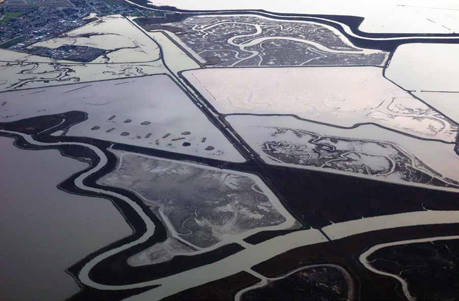
In Genesis it is written, “Let the waters under the sky be gathered into one place, so that the dry land may appear. . . . And it was so” [1-1].1 Although water is said to still occupy two-thirds of our planet’s surface, we live primarily on the land, on terra firma. In making landscape architecture, this land—topography—is primary in all but the most unusual of commissions. Earth is the surface upon which we work, and earth is the material with which we begin our designs. As soil, it provides the nutrients necessary for vegetal life. As a medium for landscape design, it is shaped, excavated, piled, and graded into varied levels and specific forms. Cutting and filling are primary acts in making almost every landscape. Although perhaps instigated by pragmatic concerns, grading inherently constitutes a sculptural act enfolding both need and expression. Today’s landscape architect emulates what in the Beginning represented only divine intervention. As proclaimed in George Frideric Handel’s Messiah, modeling the land was part of the Creation: “Every valley shall be exalted: Every mountain and hill made low, the crooked straight, the rough places plain.” If not quite to the same extent, the landscape architect also intervenes by reshaping the land, according to a plan.2 At times humans do play God and make their own land, however; Venice and much of the Netherlands provide excellent examples of this form of creation. When asked what plans had been made for the architecture and landscape of the recently constructed Ijmeer housing development in Amsterdam, Dirk Sijmons responded: “We don’t have any specific plans as yet; we have to finish designing the land first.”3 A related story involves Máxima, or Leidsche Rijn Park designed by West 8, also in the Netherlands, whose construction began in 1997. On a bicycle tour on the park’s loop path when construction was still underway, West 8 principal Adriaan Geuze pointed to the sand and earth piled where the then-dammed river would eventually flow and told me: “The Rhine will be over there, but we haven’t finished making it yet” [1-2].4 Or consider the seemingly natural landscape of New York’s Central Park that in actuality demanded the complex conversion of diverse terrains to shape a landscape to
MARC TREIB 1-1
Salt evaporation ponds. San Francisco Bay, California.
11
ORO Editions
accommodate social use, traffic, address environmental demands, and provide water storage. The Olmsted-Vaux design for the park bundled all those needs within a landscape that appears to have survived from some primordial era, long before Manhattan was settled by Europeans. Not so, not at all. From these historical references and contemporary anecdotes we understand that land can be made as well as remade, and that the form of that land is consequential.
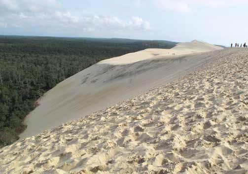
While we often consider land a static entity, it is in fact an active material continually reshaped by environmental forces and human efforts. Sand dunes, whether those of the great African deserts or the anomalous Grand Dune du Pilat in southwestern France, are always on the move [1-3]. Mountains erode; their sediment and debris fill estuaries and rivers or are carried to the sea. Displaced by glaciers, uncounted tons of rock, soil, and rubble may travel hundreds, even thousands of miles. Ultimately, then, we recognize that land is created through explosion, erosion, and sedimentation, by building up and wearing down, by inorganic and organic processes and through human intervention. The Grand Canyon in Arizona may be America’s most dramatic exemplar of erosion, but it has resulted from forces and processes that act upon all land, although their resulting forms are rarely so spectacular [1-4].
Animate yet nonhuman activities also remake the land. Animals dig holes to bury food, others make burrows for habitat, or some, such as ants and termites, build structures that can rise meters above the ground. A beaver dam can instigate the inundation of vast areas of territory, modifying local ecosystems to a significant degree. The human transformation of the land, then, is but the culmination and perhaps most rapid and consequential of the geologic and animal processes. Humans possess the means to effect major transformations in a short period of time; occasionally, we determine the need and exert our will. We do not always make these decisions wisely, however, as the 1930s attempt to build the Cross-Florida Barge Canal clearly revealed: an unfortunate example of bad digging.5
Humans reshape the land for environmental management by blocking the wind; trapping the sun; and storing, stifling, and redirecting the flow of water. By modifying the land we address functional needs such as transportation and defense, and spiritual needs such as worship, burial, and remembrance. While the scales of these applications may vary to an exponential degree, the acts remain basic: digging, piling, and shaping singly or in combination.
ORO Editions
1-2
West 8.
Leidsche Rijn (Máxima) Park. Utrecht, the Netherlands, 1997–2012. [Marc Treib, 2011]
1-3
Dune de Pyla, France. [Marc Treib]
1-4
MARC TREIB > REFORMING TERRAIN
Grand Canyon, Arizona. [Marc Treib]
ORO Editions

protect and preserve the sacred. The kofun, the circular or keyhole-shaped burial mounds of seventh-century Japan, still dot areas of the Yamato plain between Kyoto and Osaka. Constructed in staged layers, the mounds have served to protect the imperial remains while their impressive elevation above the ground plain in itself bestowed significance on their sacred deposits. Soil was thus a medium to ensure a presence in eternity. The pyramids at Giza in Egypt, or those constructed by several cultures in Mesoamerica, represent the extreme efforts in this class and call into question at what point piles of earth faced with stone are more fairly regarded as architecture rather than earthworks.
On a smaller scale is the memorial knoll at Woodland Cemetery in Enskede, outside Stockholm, the work of architects Sigurd Lewerentz and Gunnar Asplund [1-12; see also 7-10, 7-11]. Much of the power of this moving landscape, whose design spanned 1915 through 1940, results from the subtle management of its grading. The ground of the cemetery’s central meadow is formed as a single sweep of earth and lawn, while the architecture of the three chapels at its limit appears to stiffen the edge of the pine forest, almost as if a retaining wall. These sites demonstrate that the two basic acts of adding and subtracting acts that always reform and transform govern all our interventions on and into the surfaces of the Earth.
Shaping
Piling and digging are inherently interrelated acts. Between them, though to some extent requiring both, is the reshaping of the land. Many works in this topographic category are functionally based: terracing a hillside for building construction or cultivation, or flattening hills to facilitate urban development, as was the case in making Seattle or Rio de Janeiro in the modern period. At the eighteenth-century Middleton Place plantation outside Charleston, South Carolina, the existing riverbank and slope were recontoured as a series of terraces to more smoothly link the plantation’s main house with the Ashley River, the principal point of arrival and departure [1-13]. Two earthen moles embraced plots of river land converted to rice growing, while providing the transition between water and land. It should be noted that at the time of their construction mechanical earth movement had yet to exist, and as in innumerable related stories throughout history from around
1-13
Middleton Place. Charleston, South Carolina, late eighteenth century. Terracing seen across the former rice fields.
[Marc Treib]
1-14
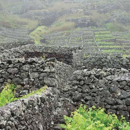
Terraced vineyards. Maia, São Miguel, Azores, Portugal. [Marc Treib]
22
MARC TREIB > REFORMING TERRAIN
ORO Editions
ORO Editions
ORO Editions
36
STEPHEN DANIELS > REPTON FOR REAL: THE PRACTICAL AND PICTORIAL
ORO Editions
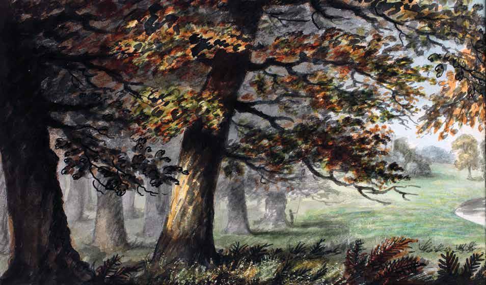
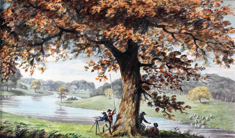
Humphry Repton. Welbeck. Nottinghamshire, England. Lake view with Repton at the theodolite. First Red Book for Welbeck, 1790. [Portland Collection, Bridgeman Images]
2-2
37
ORO Editions
44
STEPHEN DANIELS > REPTON FOR REAL: THE PRACTICAL AND PICTORIAL
ORO Editions
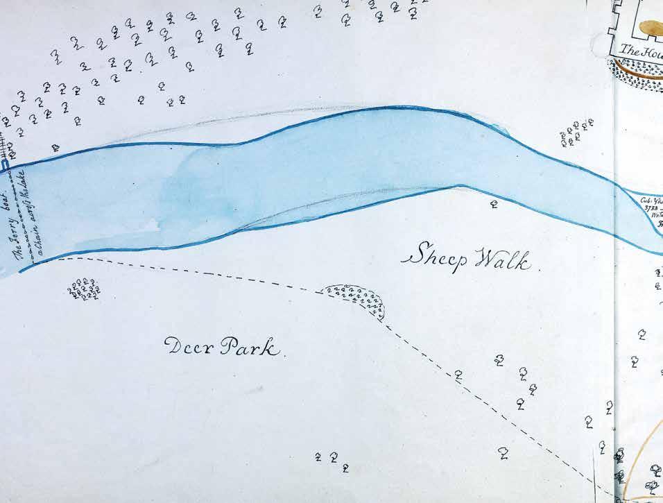
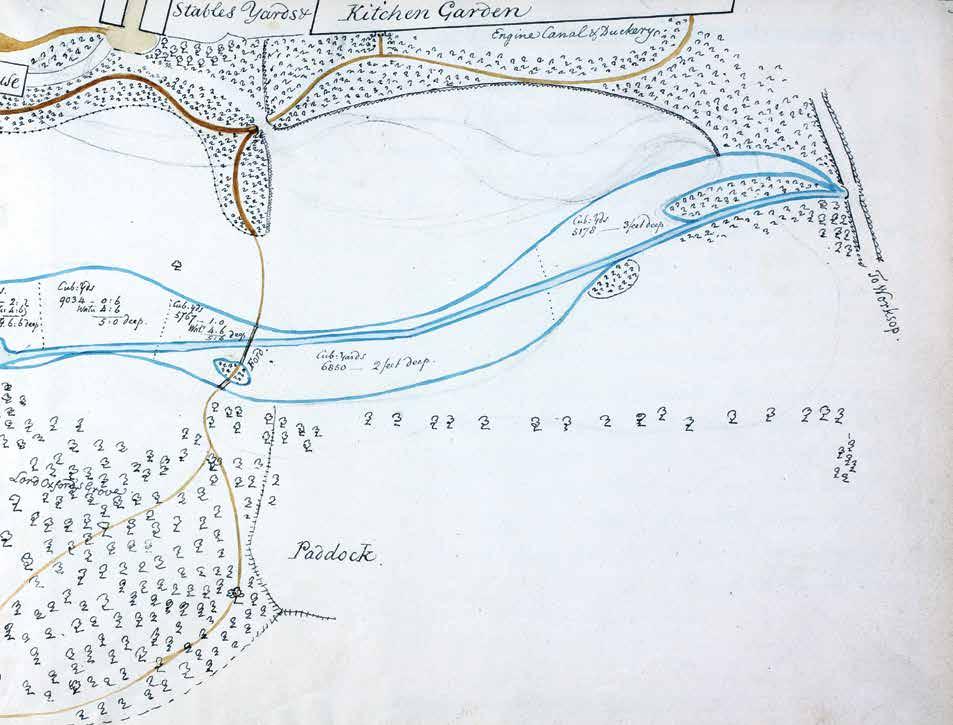
Humphry Repton. Welbeck. Nottinghamshire, England.
Map showing excavation for extension of the lake. First Red Book for Welbeck, 1790. [Portland Collection, Bridgeman Images]
2-6
45
TRASH TOPOGRAPHY: SHAPING POSTINDUSTRIAL LAND
ORO Editions
168
9.
ELISSA ROSENBERG
Form and Formlessness
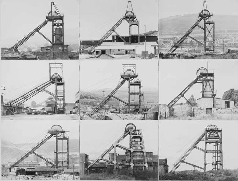
In the 1950s, long before apocalyptic views of emptiness and picturesque urban decay filled photography collections and popular magazines such as Time and Life, photographers Bernd and Hilla Becher began their systematic documentation of Germany’s industrial architecture [9-1]. 1 The abstract quality of the Bechers’ images aestheticized these abandoned water towers, blast furnaces, gas tanks, mineheads, and grain elevators; they were shot frontally in black and white, stripped of their contexts, and generally organized in a grid. The Bechers referred to them as “anonymous sculptures.”2 By transforming these derelict structures into objects of beauty and granting them architectural value, the Bechers’photographs made an important contribution to a nascent industrial aesthetic.
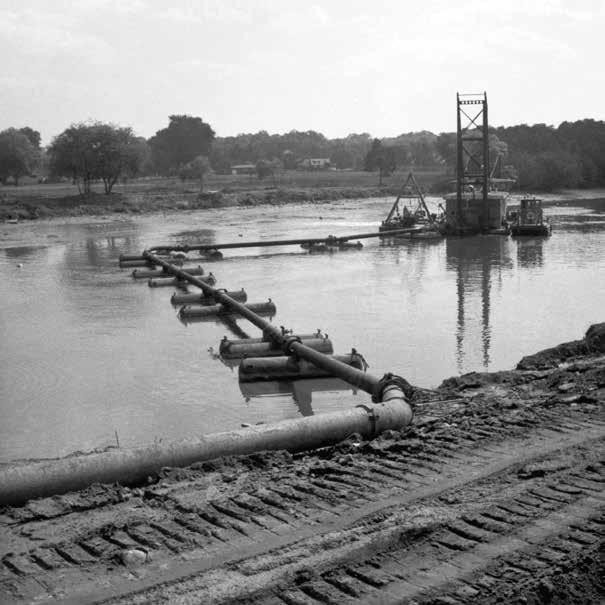
Around the same time the Bechers were recording abandoned mining sites, artist Robert Smithson was exploring the postindustrial landscape. “My own experience,” he wrote, “is that the best sites for ‘earth art’ are sites that have been disrupted by industry, reckless urbanization or nature’s own devastation.”3 In 1967, he published his celebrated essay “The Monuments of Passaic” in Artforum, a tribute to the industrial remnants of Smithson’s hometown in New Jersey.4 Using a cheap Instamatic camera, he extolled the banal decaying “monuments” of the contemporary American city: the steel bridge, the “fountain monument” of sewage-outfall pipes, parking lots, and a suburban sandbox [9-2].
A year later Smithson joined the Bechers on a “field trip” to Oberhausen, one of the largest industrial complexes in the Ruhr district, not far from Düsseldorf, where Smithson was to have his first solo exhibition. Smithson’s snapshots from that visit stand in stark contrast to the Bechers’ analytic and even elegiac photographs. While the Bechers were preoccupied with the subtle formal aspects of the industrial structures, Smithson was drawn to the formlessness and disintegration of the surrounding landscape: the wasted ground, the mounds of slag, the marks left by tires. Terrain, he held, was a constantly changing, physical material, subject to what he called “chance and change in the material order of nature.”5
ORO Editions
9-1
Bernd Becher and Hilla Becher. Pitheads, 1974. [© Estate of Bernd Becher & Hilla Becher, Tate Collection]
169
ORO Editions

170
9-2
Robert Smithson. The Pumping Derrick. “The Monuments of Passaic,” Artforum (December 1967).
[Robert Smithson; © Holt/Smithson Foundation / VAGA at Artists Rights Society (ARS), NY]
9-3
Andrew Moore. Birches Growing in Decayed Books
Detroit Public Library Book Depository, 2010.
[© Andrew Moore, from Detroit Disassembled]
With the shift from a production economy to a serviceoriented consumer economy, the abandoned sites of industry and disused infrastructure have become the new ground of our public realm. Parks built on the sites of empty blast furnaces; abandoned quarries; or decommissioned rails and railyards, landfills, and ports have generated a renewed fascination with industrial sites. Much has been written about the current “ruin craze,” which has sparked a voyeuristic interest in industrial heritage in ghost towns and waste sites, from Fukushima to Detroit.6 Ruins have become aestheticized and stripped of social context as sites for “ruin tourism,” destinations that today attract outsiders with no stake or interest in the city a trend derisively termed “ruin porn.”7 A new postindustrial aesthetic has come into focus, largely as viewed through the photographer’s lens.8
Many of the images of urban decay that feed this aesthetic draw upon romantic notions of inevitability, showing images of empty lots reverting to fields or trees sprouting in abandoned buildings [9-3]. Nature seems to be reclaiming the city as a powerful yet external force that exists beyond human life and history.
The conversion of these sites to public use has required landscape architects to think and work in new ways, transforming landscapearchitectural practice as well as its theories.9 To what extent do recent designs play to prevailing landscape conventions, such as the picturesque or the sublime, or even ruin porn and how do they challenge them? Geographer Matthew Gandy has argued that “urban wastelands unsettle the familiar terrain of cultural landscapes, designed spaces, and the organizational logic of modernity.”10 In response to these conditions an alternate aesthetic is emerging from recent postindustrial landscape projects marked by their engagement with terrain. Rather than focusing on the Romantic imagery of ruin, the key element in the remediation of these sites is the earth itself: disturbed, eroded, toxic soils; or oozing trash. In his 1973 essay “Frederick Law Olmsted and the Dialectical Landscape,” Smithson underscored the primacy of the earth: “a consciousness of mud and realms of sedimentation is necessary in order to understand the landscape as it exists.”11 He and other land artists working on reclamation sites in the 1960s and 1970s used earth as a sculptural medium to express a range of themes that ranged from disruption, devastation, and entropy (Smithson), to earth as “a thing in itself” used to support living systems (Helen and Newton Harrison).12
171 ORO
Editions
10-11
Studio AKKA
Grounds of the White Mansion. Bled, Slovenia, 2010. Topography enhanced by leveling.
[Peter Koštrun]
10-12
Studio AKKA
Grounds of the White Mansion. The sway of topography capped by a narrow platform directing the view.
[Peter Koštrun]

ORO Editions
200
ORO Editions
201
11-15
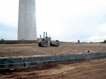
Washington National Monument.
Contouring the knoll. Washington, DC, 2004.
11-16
Laurie
Washington
[Kathleen John-Alder]
Olin and Project Design Team.
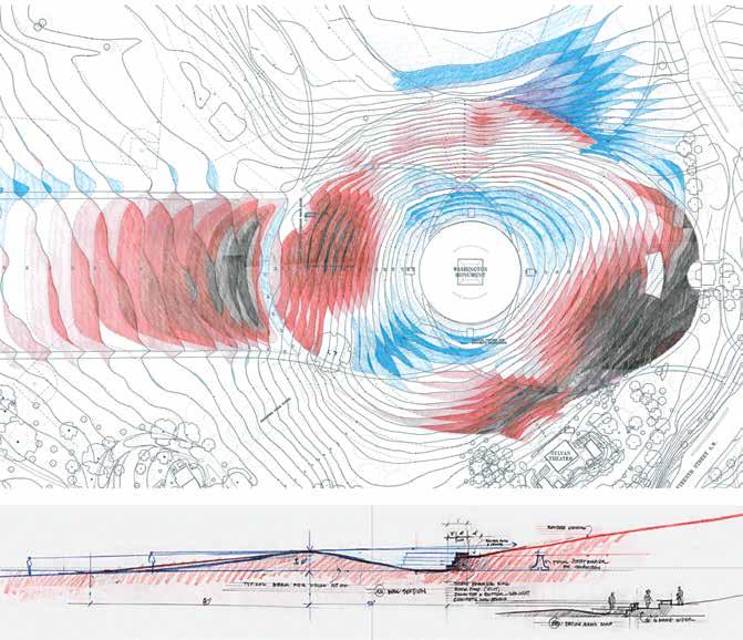
National Monument. Washington, DC, 2002. Security-design cut-and-fill grading plan.
(above): Within 200 feet of the obelisk less than one foot of soil was disturbed; (below): Cross section through the security wall, showing the care taken to screen it from the Lincoln Memorial.
222
[The Olin Studio]
ORO Editions
11-17
ORO Editions
11-18
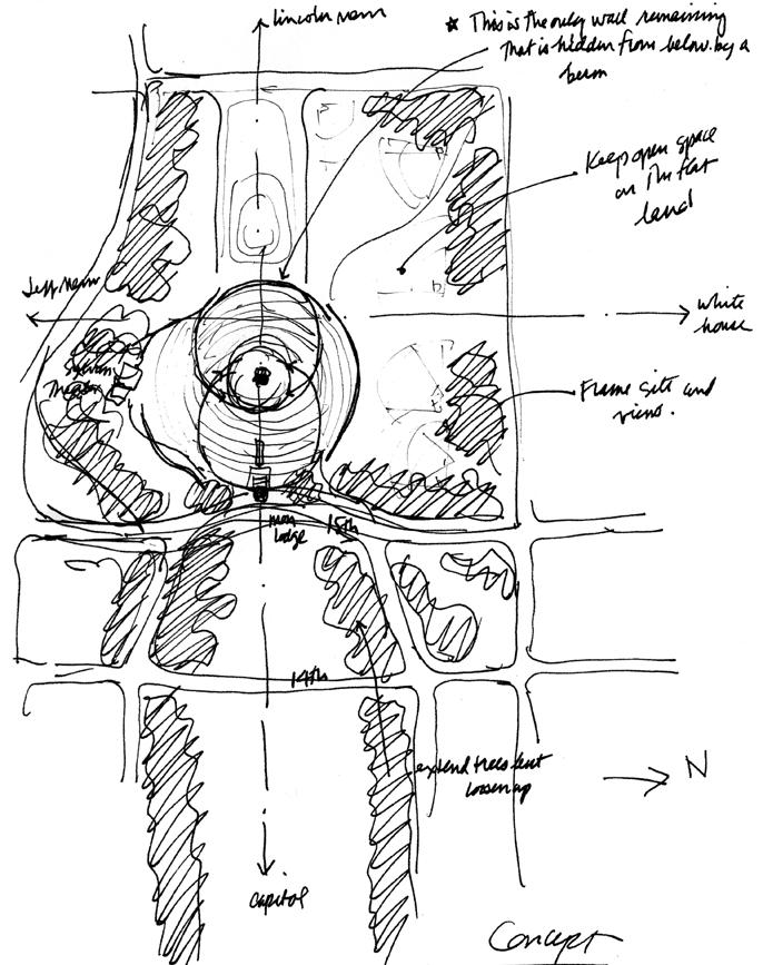
Laurie Olin. Washington National Monument security design. Washington, DC, 2001. Concept sketch. [The Olin Studio]
223
Laurie Olin. Buscot House and Park. England, late eighteenth century. Sketch of the lawn and ha-ha, 1995. [from Across the Open Field: Essays Drawn from the English Landscape]
ORO Editions
13-13
Michael Van Valkenburgh Associates.
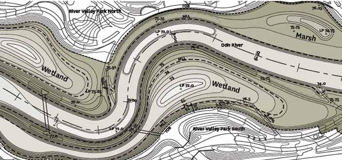
The Port Lands. Toronto, Ontario, 2017–23. New river grading plan. [MVVA, 2019]
13-14
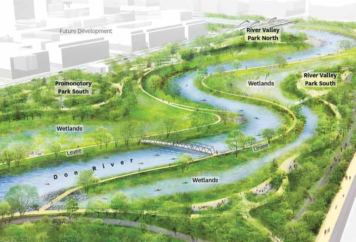
Michael Van Valkenburgh Associates.
The Port Lands. The three topographically defined corridors in the valley: river, levees, and wetlands. [MVVA, 2019]
260
13-15
Michael Van Valkenburgh Associates.
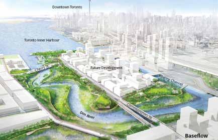
The Port Lands. Toronto, Ontario, 2017–23. Base-level river flow. [MVVA, 2018]
13-16
Michael Van Valkenburgh Associates.
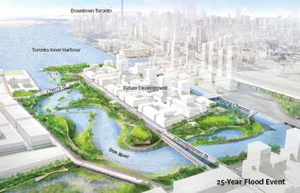
The Port Lands. Twenty-five-year storm event. [MVVA, 2018]
13-17
Michael Van Valkenburgh Associates.
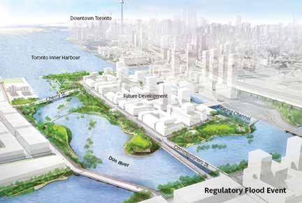
The Port Lands. Regulatory storm event (High Flood stage). [MVVA, 2018]
261 ORO
Editions
ORO Editions