


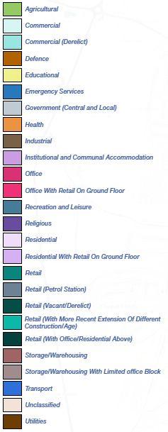
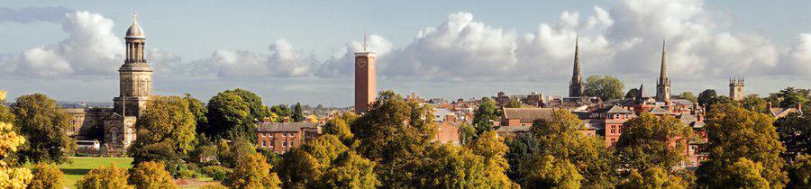
 LUDLOW SHREWSBURY


 The Parish Church, Ludlow
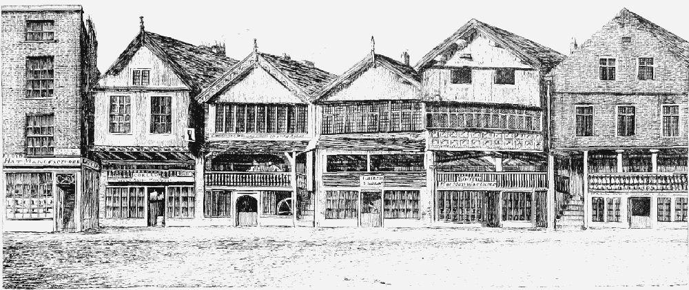
The Broad gate, Ludlow Feathers hotel, Ludlow
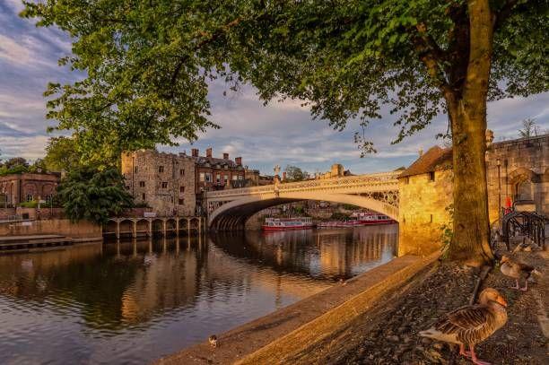
The York Minster, York
Model around York Minster, York Boating on the River Ouse, York
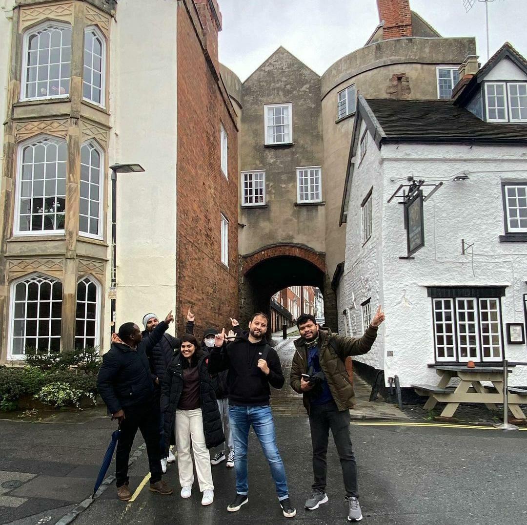
Eastgate Clock, Chester
King Charles Tower, Chester Crown Court, Chester
The Parish Church, Ludlow
The Broad gate, Ludlow Feathers hotel, Ludlow
The York Minster, York
Model around York Minster, York Boating on the River Ouse, York
Eastgate Clock, Chester
King Charles Tower, Chester Crown Court, Chester
Chester was originally settled by the Romans in the first century AD and called Fortress Diva, after the River Dee upon which it stands.
By the Middle Ages, Chester had become a wealthy trading port.

During Victorian times the magnificent gothic-style Town Hall was built and the Eastgate Clock was erected in honour of Queen Victoria’s Diamond Jubilee.
The famous city Walls, originally built by the Romans and today a walk of around two miles, offer a superb elevated view of the city on one side and a view of the distant Welsh mountains on the other.
Sketch of 15th century timber framed house on Goodramgate Street in York. York is a cathedral city of Roman origin, located at the confluence of the rivers Ouse and Forth in North Yorkshire, England.


It is the historic city of Yorkshire. The city boasts historic buildings and other structures such as churches, castles and city walls.
Many of the buildings in York remain essentially unchanged from medieval times. One striking example of this is the Shambles, a neighborhood of narrow streets and passages known as snickelways.
The building shown in the sketch is in Goodramgate Street, also of medieval origin and of timber framed construction. It is now a unique style of restaurant bar and shop.
Sketch of Eastgate clock Chester


INTRODUCTION


 Historic image of Broadstreet from 1934
Historic image of Broad gate from 17th century
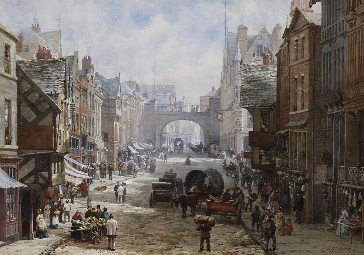
Historic image of Eastgate Street from 1924
View of Chester by William Smith from 16th century
Historic drawing of York from 15th century
Historic image of York from 1920
Shrewsbury in ‘The Great Frost’ of 1739
Historic image of Broadstreet from 1934
Historic image of Broad gate from 17th century
Historic image of Eastgate Street from 1924
View of Chester by William Smith from 16th century
Historic drawing of York from 15th century
Historic image of York from 1920
Shrewsbury in ‘The Great Frost’ of 1739


Shrewsbury Chester
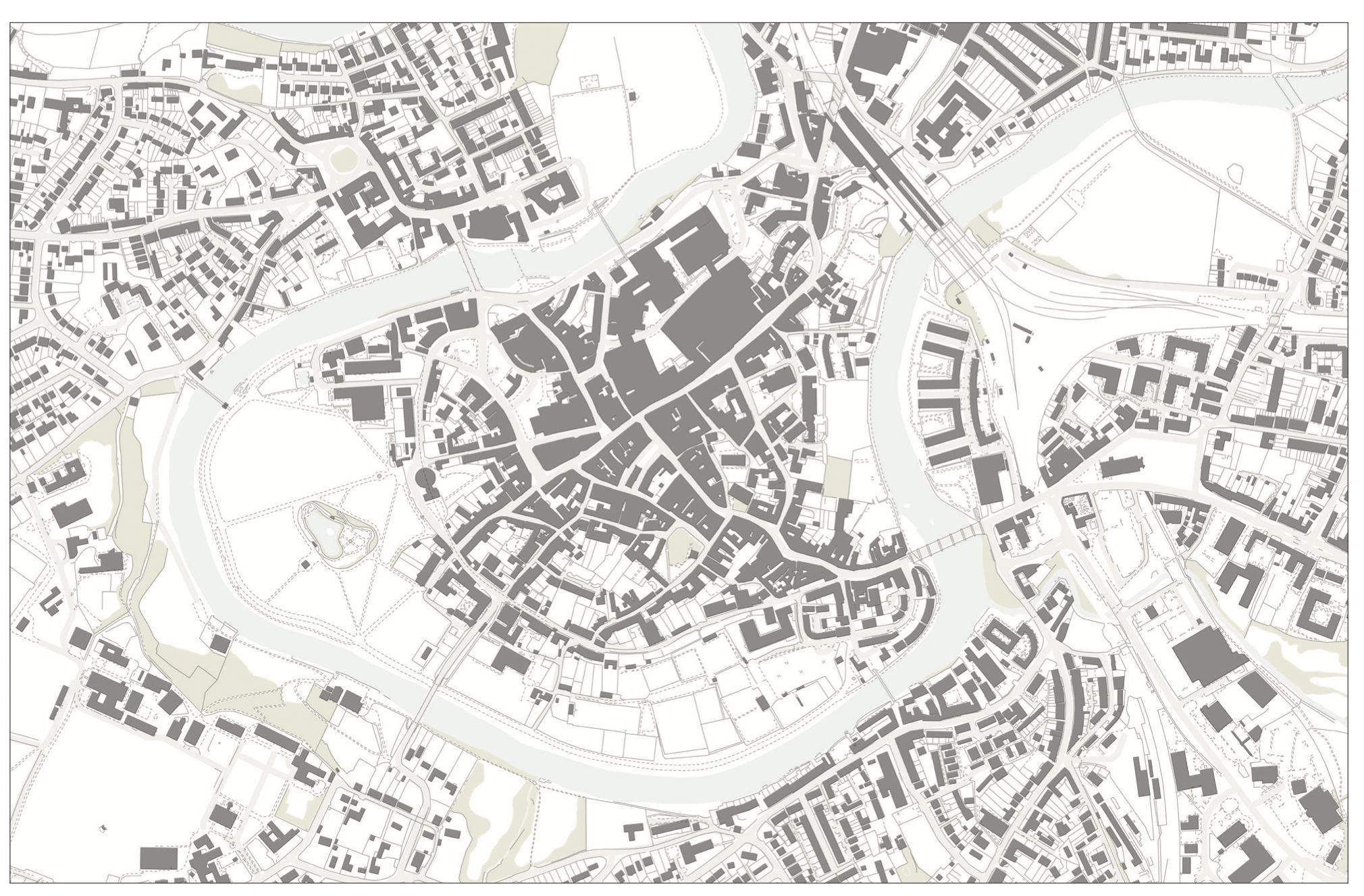
ChesterTown Plan 1880
ChesterTown Plan 1900s
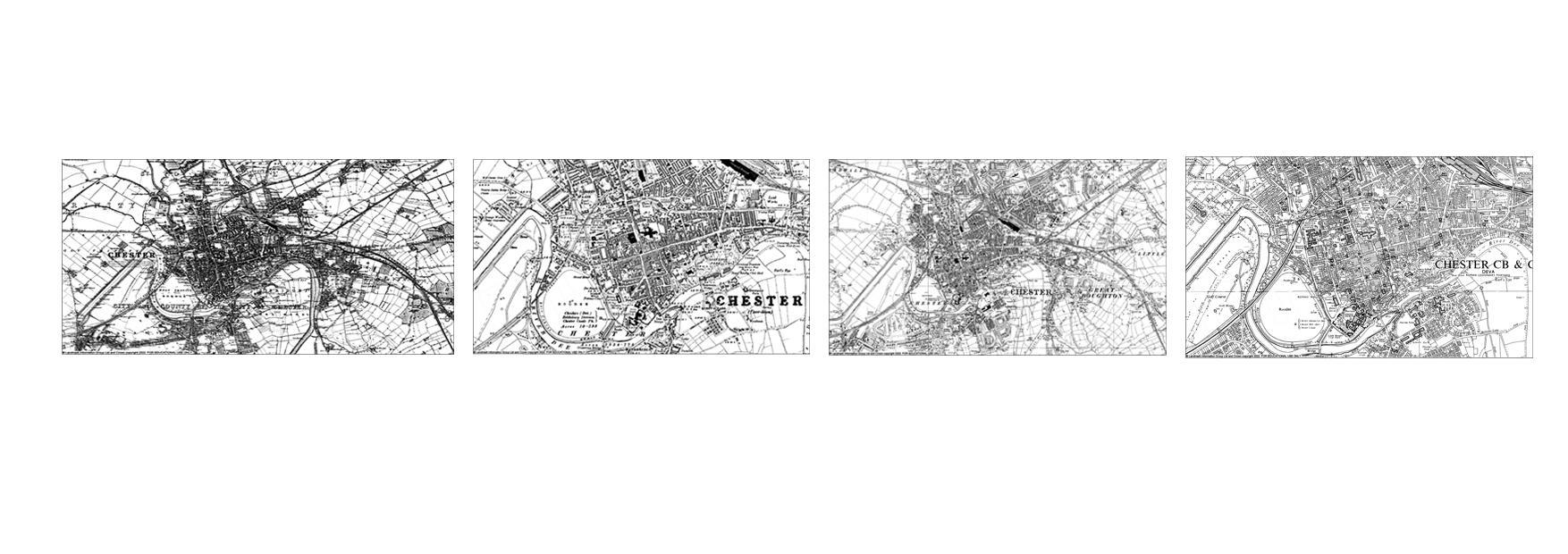
ChesterTown Plan 1930s
ChesterTown Plan 1960s
ShrewsburyTown Plan 1800s
ShrewsburyTown Plan 1900s
ShrewsburyTown plan 1930s
ShrewsburyTown Plan 1980s
Ludlow York
Ludlow Town plan 1880


Ludlow Town plan 1900s

Ludlow Town plan 1930s
Ludlow Town plan 1980s
York Town plan 1850
York Town plan 1910s
York Town plan 1940s


York Town plan 1990s

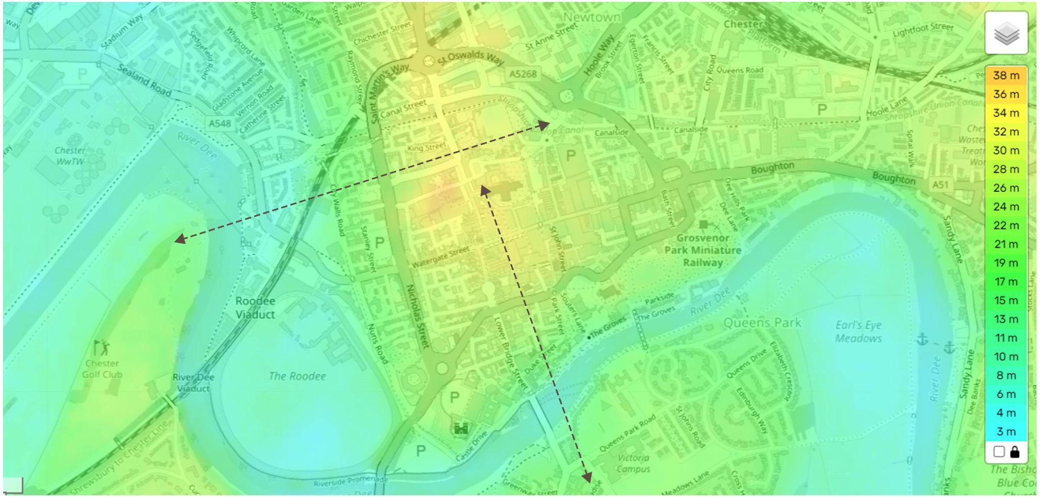
Chester is a gently sloped town.The Highest point in Chester is Bulkeley Hill, and the lowest point is in Chester is River Dee.
Average elevation is approximately 61m.


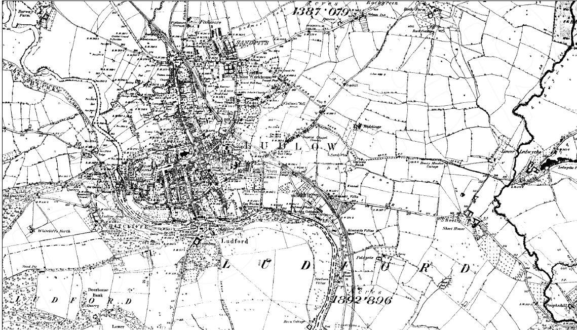
Ludlow is located on a small hill with the castle and the church located at the highest point. The streets slope downwards towards the Rivers Corve and Teme ,to the north and south respectively.
Average elevation is approximately 110m.
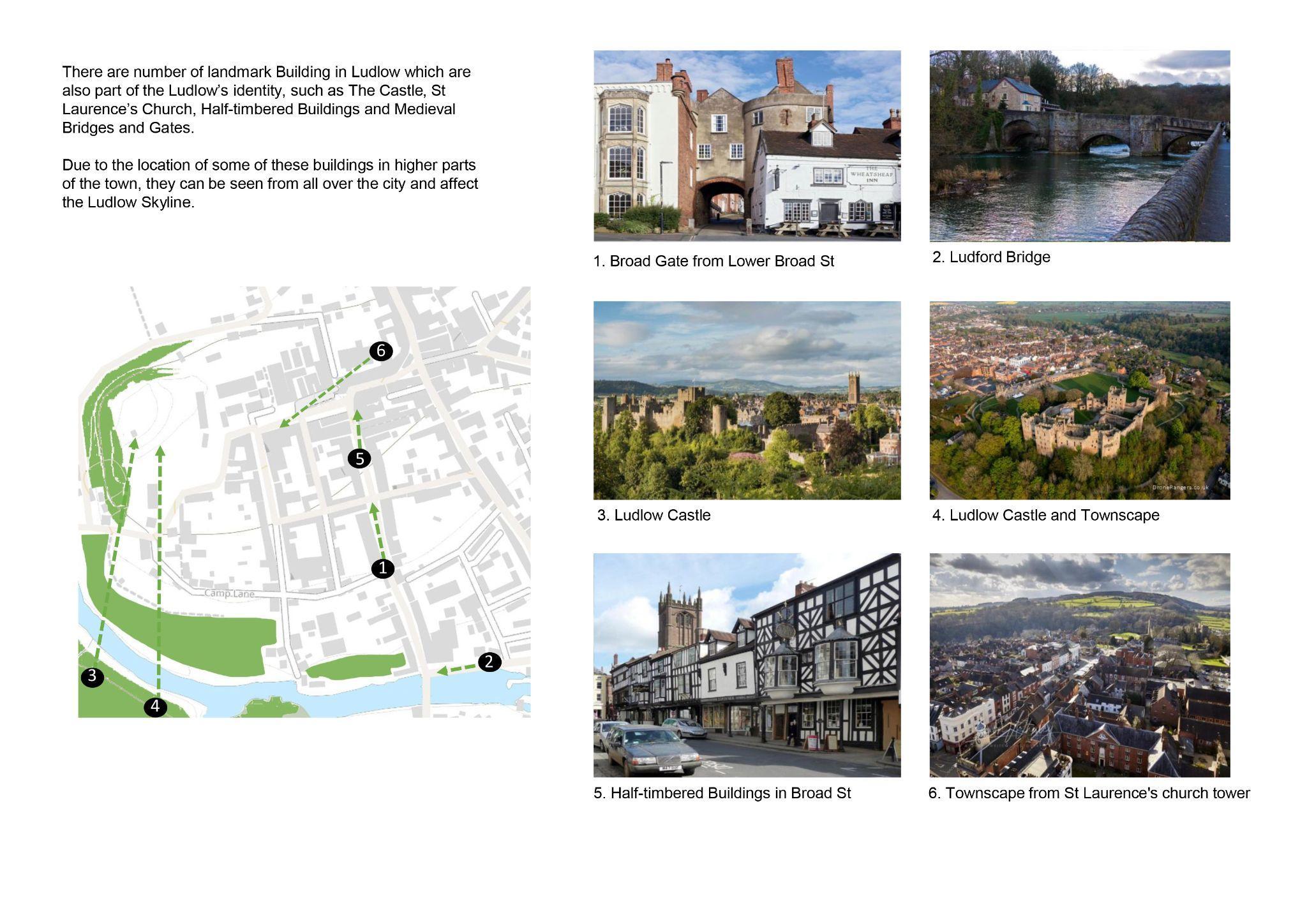
Topographically the center of the town is at a height, this allows to get a panoramic view of most of the landmarks.
The topography also reduces flood risks in the center.
The area of intervention around rivers Ouse and Foss is exposed to a serious risks of flooding, since it is the lowest area on height, compared to more westward and eastward areas of the city
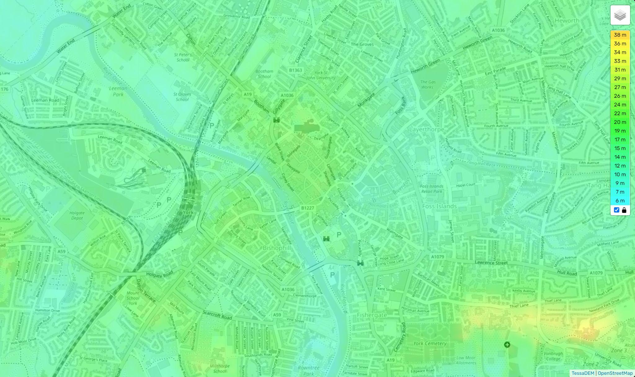


Map displaying elevation Section through York city core


Shrewsbury York
Historical Maps
● All 4 towns were established near prominent rivers.
● All 4 towns have castles and churches as their first buildings.
● All 4 towns were fortified by walls built around them.
Growth patterns and Town development
● All 4 towns were initially surrounded by open farm lands that were built upon as the town expanded.
● Chester, Shrewsbury and York grew rapidly largely due to industrialisation whilst Ludlow experienced a stagnated growth in the 19th century due to various factors including economic decline due to inaccessibility to the canal network


● York is the largest town in terms of area and population whereas Ludlow is the smallest town
● All the towns are defined by medieval, tudor and georgian architecture Some of the historical buildings in York, Chester and Shrewsbury have been transformed due to rapid growth and modernisation and lately tourism. Ludlow has largely preserved its historic buildings with the same function to date.
● All the towns have maintained the medieval planning patterns, with expansion away from its core.
● Town centres are located within the walls with mixed-use (retail on ground and residential above) with the suburban development towards the outskirts.
● Most residential buildings are restricted in elevation up to 3 stories, which allows the city landmarks to stand out and be visible from far off distances.
Topography
● While York and Chester are relatively flat, Shrewsbury is higher at the centre of the town and Ludlow has a steep slope towards the river.
Plot typologies
● All four towns initially had long and narrow plots which have now been subdivided into smaller plots due to demand.
Chester Ludlow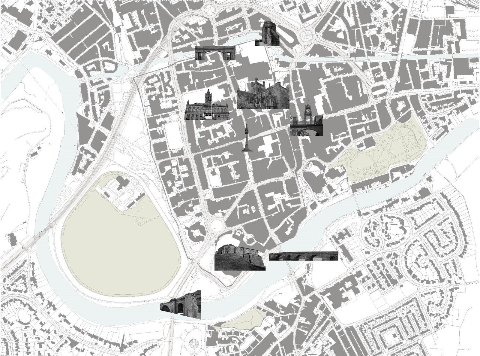


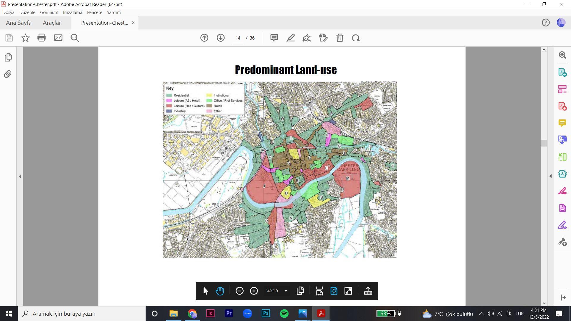
Land use plan


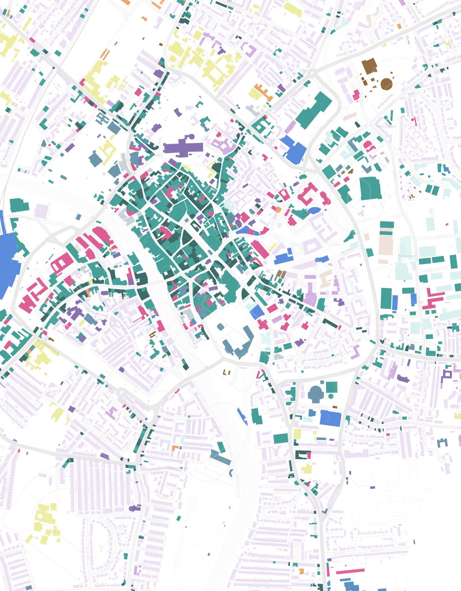


Building morphology Plan
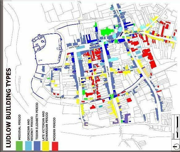
BUILDING ERA, YORK
 Source -Comert and Hoskara ,2021 -Journal titled “Typo-morphological assessment of Ludlow and Famagusta


Chester’s strong grid layout and historic built form means that in general the city has strong building lines and well-defined and well-enclosed streets and spaces. The exception to this is the ring road, particular the purpose built sections which cut across the historic urban grain. This creates some streets and spaces with poorer enclosure at some of the key entry points to the city. In addition, many of the internal side streets within perimeter blocks tend to have weaker building lines, resulting in pockets of incoherent urban form.


The street currently acts as akey vehicular thoroughfare into the town, providing movement for cars, service vehicles and buses. The street is home to a number of shops and restaurants which require drop-off and pick-up facilities. All of which contributes to a busy street scene, dominated by traffic.
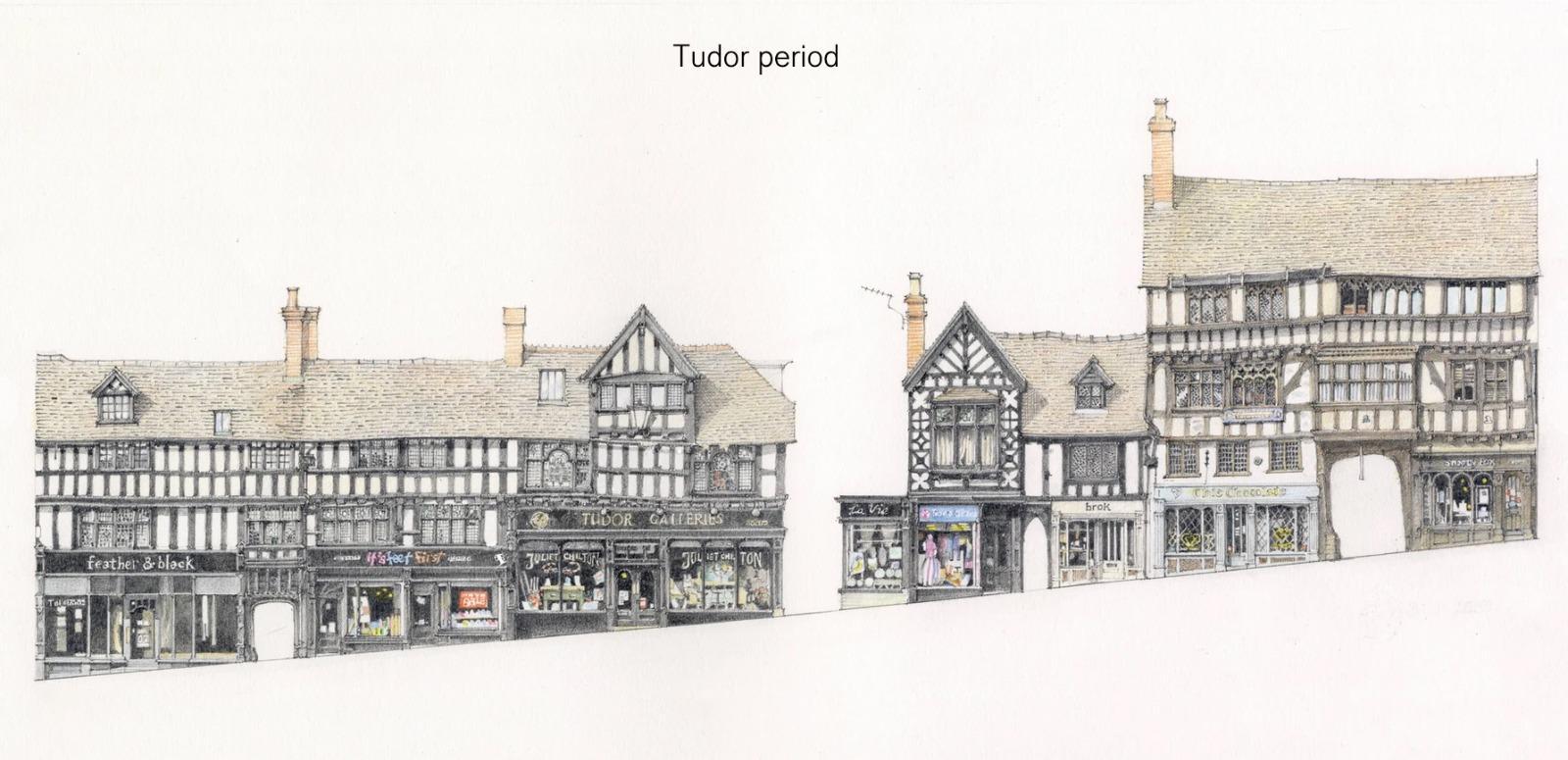
The area has a rich palette of architecture with the medieval and Tudor styles prevalent. More recent Victorian architecture is seen within infill plots to the north and south. The meandering street scene creates a number of interesting corners and edges up and down the main street. This provides a key features along the route, including gable ends, building frontages and spaces. The form of the area, however, does mean that legible routes into the town are not instantly recognisable. Wayfinding would help in terms of guiding people towards Pride Hill via Castle Street.
There are dozens of streets in York which are worthy of preservation. The above plaques were installed separately, at different periods and for a variety of reasons. Although they present a mixed picture, in combination they are a valuable illustration of how the development of York streets exemplifies the city’s history. Four of them are named by the authoritative Royal Commission on Historical Monuments as of ‘paramount importance to preserve’: Minster Gates, High and Low Petergate, Shambles and Stonegate.

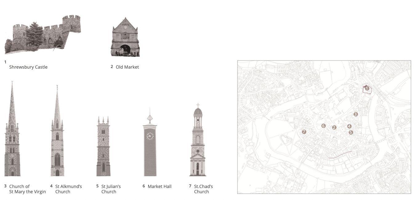
Shrewsbury


York


The primary retail area is concentrated around The Rows and extends along the ‘cross streets’ to the city walls to the north and south. The Rows themselves provide a unique first floor galleried walkway edged by shops and businesses, many of which are independent.

Within and around the City Walls there is a rich mix of other uses including offices and professional services, residential developments including city apartments and more traditional housing, cultural and civic uses and leisure uses.
The most important attraction of the town is the market square This public area is used as thelocal hub for centuries.It is the commercial heart for the town that encourages local entrepreneurs


Other site of Public realm is the riverside recreational areas. Lush green natural landscape lead to a serene environment.


 Chester Roman Amphitheatre
Chester Roman Garden
The Groves
Chester Race cousre
The Rows
Chester Roman Amphitheatre
Chester Roman Garden
The Groves
Chester Race cousre
The Rows
The walled city is not a place of formal public spaces, such as grand squares. They did not form a part of the medieval townscape. Instead, the characteristic public spaces of the walled city are the intimate, informal squares at the junctions of streets and where markets are held and churches were located. These are a part of the organic street network and architecturally are defined by variety and juxtaposition: there are few unified or formal frontages. There is little green space within the densely-packed walled city. What there is is either a legacy of the medieval church the Minster precinct, the parish churchyards and the grounds of St Mary's Abbeyor the medieval defences - the ramparts and mound of Clifford's Tower


 St Peter School Ground Public Realm in front of York Cathedral
Green open Spaces on the backside of St Peter School King Staith public gathering
St Peter School Ground Public Realm in front of York Cathedral
Green open Spaces on the backside of St Peter School King Staith public gathering
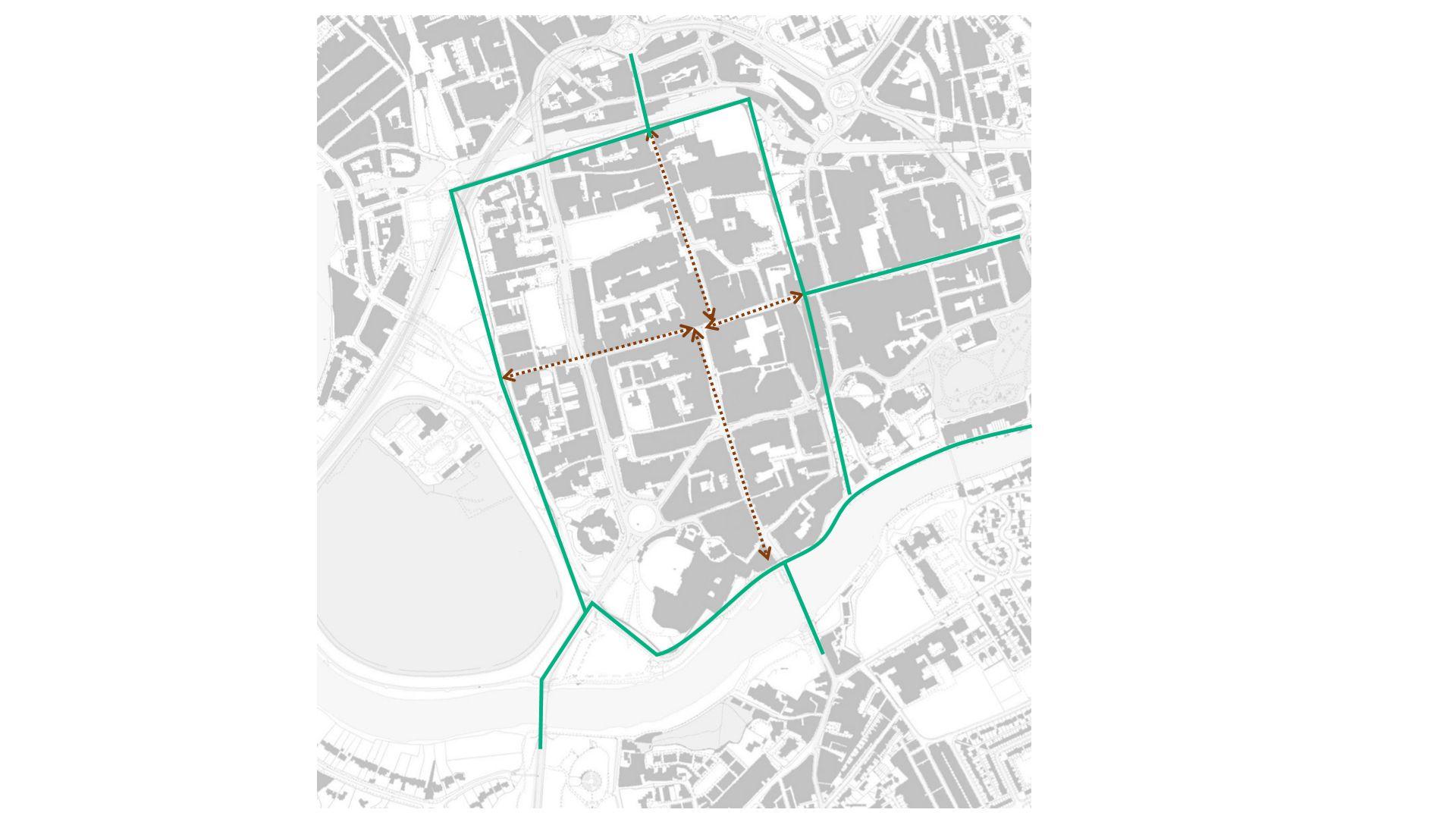
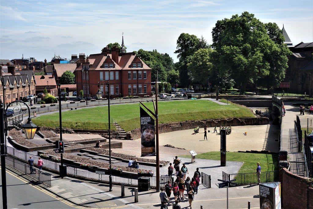
Chester offers many distinguished landmarks, from architectural and heritage features like the city wall, bridges, castle, cathedral, and the Cross. Most of these buildings are visible from the city wall and different locations within the grid.


The city wall offers an elevated view of the city on one side with the canal, Dean’s field with the Cathedral, and a view of the distant Welsh mountains. Moreover, the city walk on the west provides an endless view of the racecourse. The Cross at the junction provides a vista of Watergate Street and Bridge Street. Another location with viewpoints is the Old Dee bridge which provides a magnificent vista approaching the city.
There are a number of landmark buildings in Ludlow which are part of its identity. The castle, the Parish church, half timbered buildings and medieval bridges form the townscape views. The contour of the town allows stunning views of the tow from its heighting point where the castle is placed. One can climb up the tower in the church as well.


The skyline is dominated by medieval buildings. Shrewsbury and York have better views to the skyline compared to Chester and Ludlow. Shrewsbury’s street planning pattern, along with the topography, enhances visual vistas to landmark buildings.Most of the residential buildings are three-storey with Georgian architecture but the undulating topography creates an interesting pattern.


Their proximity to nearby farms gives the skyline a natural feel.Though the towns have changed over time, they still relate to their rural and farming surroundings.

Present wall location Past wall location
Present wall location
Past wall location
Ludlow York
Present wall location


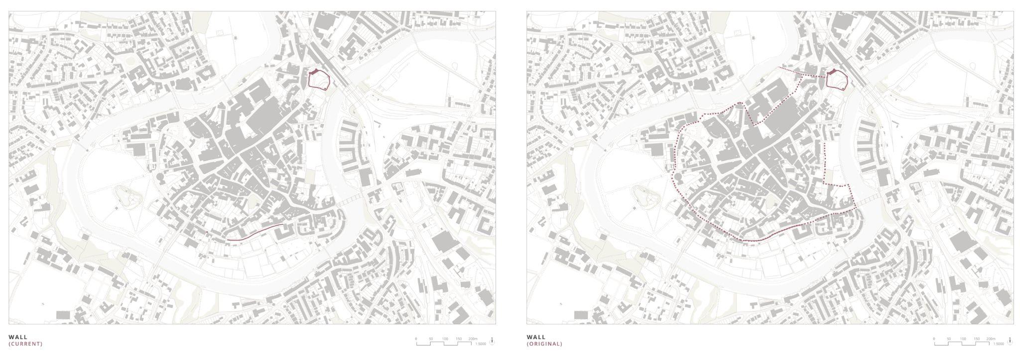
Past wall location
Present wall location Past wall location
Ludlow
●
Construction period: 11th to 14th century
● First Builder: Walter de Lacy
● Purpose: defend the Welsh border and subdue the local Anglo Saxon population.
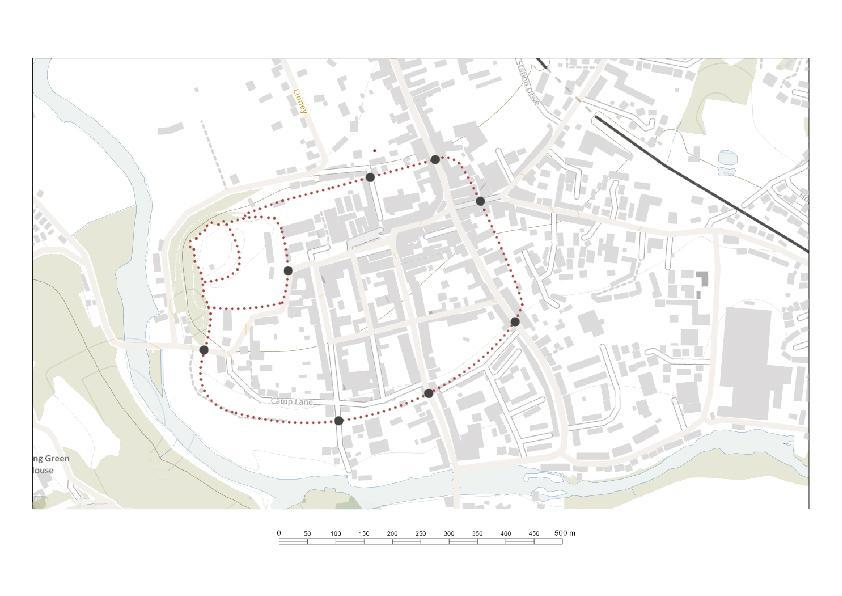
● Ludlow's city walls date back to the 13th century, when they were built to protect the town of Ludlow in Shropshire, England from Welsh raids and the threat of civil war.

● They include parts of the existing town, utilizing Ludlow Castle, including eight gates and at least three frescoed towers.

● After the 16th century, they gradually declined.
● Broad gate, at the bottom of Broad Street is the sole surviving medieval gate


Material
● Constructed of local grey calcareous siltstone rubble
● A somewhat brittle grey calcareous siltstone
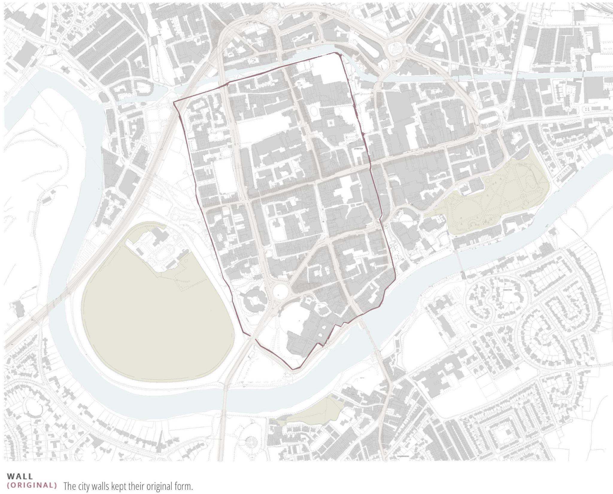
York
YORK CITY WALLS

Construction period: 71AD (into stone walls in 13th centuryAD)

First Builder: Romans (IX Legion under Quintus Petillius Cerialis
Purpose:
● Military fortress against the Brigantes tribes of Northern England
● Military headquarters for the Vikings during Danelaw
● Defence against outside enemies during the War of Roses, English Civil War, and Jacobite Rebellion
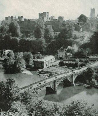
York has, since Roman times, been defended by walls of one form or another. Initially erected with timber, the castle walls were rebuilt into stone during Henry III’s reign in the 13th century. They were fully restored with footpaths during the Victorian era. To this day, substantial portions of the walls remain, and York has more miles of intact wall than any other city in England.
They are generally 4m high and 1.8m wide.
The walls are punctuated by four main gatehouses, or 'bars’. These restricted traffic in medieval times, and were used to extract tolls, as well as being defensive positions in times of war
CITY WALLS
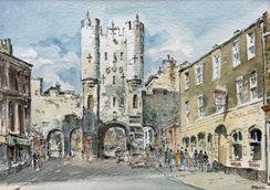
Built mostly during the 14th century, although the inner gateway dates from the 12th century. It is most notable for its barbican, the sole surviving one on a town gate in England. It also retains its portcullis and has reproduction 15th century oak doors.
Βuilt in the early 14th century, this four-storey gatehouse is the tallest and most elaborate of the four. It was intended as a self-contained fort, with each floor capable of being defended separately.Today, Monk Bar houses a museum called the Richard III
Experience at Monk Barand retains its portcullis in working order.
Built in the 14th and 19th centuries, has some of the oldest surviving stonework, dating to the 11th century. It stands almost on the site of porta principalis dextra the north western gate of Eboracum.
It was the traditional ceremonial gate for monarchs entering the city, who, in a tradition dating to Richard in 1389, touch the state sword when entering the gate.
Walmgate Bar Monk Bar Bootham Bar Micklegate BarChester Shrewsbury
•The City Wall is the oldest, longest, and most complete in Britain.
•The only complete circuit wall in England is rectangular in plan, on a continuously elevated walkway overlooking the bank of the River Dee with the Shropshire Union Canal connecting the river in the North.
•The four main gateways are–Northgate, Eastgate, Watergate, and Bridgegate. Also, there are many other steps around the city wall, some including access ramps.
•There are two main towers- Phoenix Tower (formerly known as King Charles Towers in the northeast corner and Water Tower in the northwest corner of the city wall.
•In 70 AD, the original walls were ramparts of earth and turf topped by a timber palisade, with towers and gates, and an outer ditch. In 90 AD, the walls began to be rebuilt in sandstone.
Construction period 1218 - 1242

First Builder King Henry III
Purpose defences from the Welsh
The walls of Shrewsbury shows little remains. It is not as significant as the walls in York and Chester. The Shrewsbury’s Town Walls Road runs alongside the ancient walls, with remaining tower (Wingfield’s Tower) along. The walls separate the town and the large recreational green space, the Quarry.
The walls gradually decayed after the Second Jacobite Rebellion in 1745.
Ludlow
York
● Ludlow's city walls date back to the 13th century, when they were built to protect the town of Ludlow in Shropshire, England from Welsh raids and the threat of civil war.
● They include parts of the existing town, utilizing Ludlow Castle, including eight gates and at least three frescoed towers.
● After the 16th century, they gradually declined.
● Broad gate, at the bottom of Broad Street is the sole surviving medieval gate
At 3.4 kilometres long, the York walls are the longest and most complete and well-preserved town walls in the entirety of England.
They were built mainly in the 13th century on top of older earth banks. There are a few bits of dry moat left around the banks. The slopes are well known for their daffodils in March and April. At other times they are grassy or covered with wildflowers.
The Walls are built almost entirely of magnesian limestone. This is a very variable stone but it often looks warmer, with variable shades of light brown-yellow than other, uniformly white-grey, limestones.
Walking the trail around the Walls is roughly like walking the edge of a kilometre square [but more interesting than this sounds!]. Each side in this square has a grand medieval fortified gateway called a “bar”.

SOURCE
Upper Reaches : From the source of the river at springs on the slopes of "Black Hill" Dduallt above Llanuwchllyn in the mountains of Snowdonia, through Wales, to its emergence from the Vale of Llangollen
Middle Reaches Through England and the Welsh borders to Chester; the "middle aged" river slows down and the valley becomes broader.
The name Teme is similar to many other river names in England, testament to the name's ancient origin.
HOW LONG IS THE RIVER TEME?
The River Teme is 130 miles (81 km) long It is the sixteenth-longest river in the UK

The River Dee - its Upper Reaches (pale blue) from the source (red dot) pass eroding and tempestuous through Wales; the Middle Reaches (dark blue) slow and meander about along the borders, and the Lower Reaches (purple) are estuaraine waters that dip to the sea dumping sediment from upstream.
WHY IS THE RIVER CALLED DEE?
Lower Reaches Back in Wales, below Chester to Hilbre Island and the sea; the river is now in "old-age" and while there is little erosion a lot of material is deposited
HOW MANY TRIBUTARIES DOES DOES RIVER DEE HAS?
River Teme’s tributaries include the River Clun, River Onny, River Corve, River Rea, Leigh Brook, and Kyre Brook.
Deva was the name given to their fortress by the Romans, which translates as divine or Goddess, and was taken from the British (Celtic) name for the then-mighty river beside which the fortress was built.
HOW LONG IS THE RIVER DEE?
The River Dee, which is about 70 miles long, rises in the hills above Llanuwchllyn in the 'Dolgellau gold belt' of Merioneth (Gwynedd) and, before it passes through Llyn Tegid (Bala Lake) it is known as Afon Dyindwy or 'The Little Dee'.
HOW MANY TRIBUTARIES DOES DOES RIVER DEE HAS?


The River Dee has three tributaries, the River Killary, the Gara River and the White River, all of which are known to have stocks of Brown Trout, Sea Trout and Atlantic Salmon. The River Dee in Wales Afon Dyfrdwy - is a sixty eight mile long river which starts life at Llanuwchllyn in Snowdonia.
Shrewsbury York
WHY THIS RIVER CALLED SEVERN?
The River Severn gets its name from the Latin word Sabrina, named by the Romans which means boundary.
HOW LONG IS THE RIVER SEVERN?
The River Severn length is 220 miles long (354 kilometres), the River Severn is the longest river in the UK.
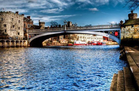
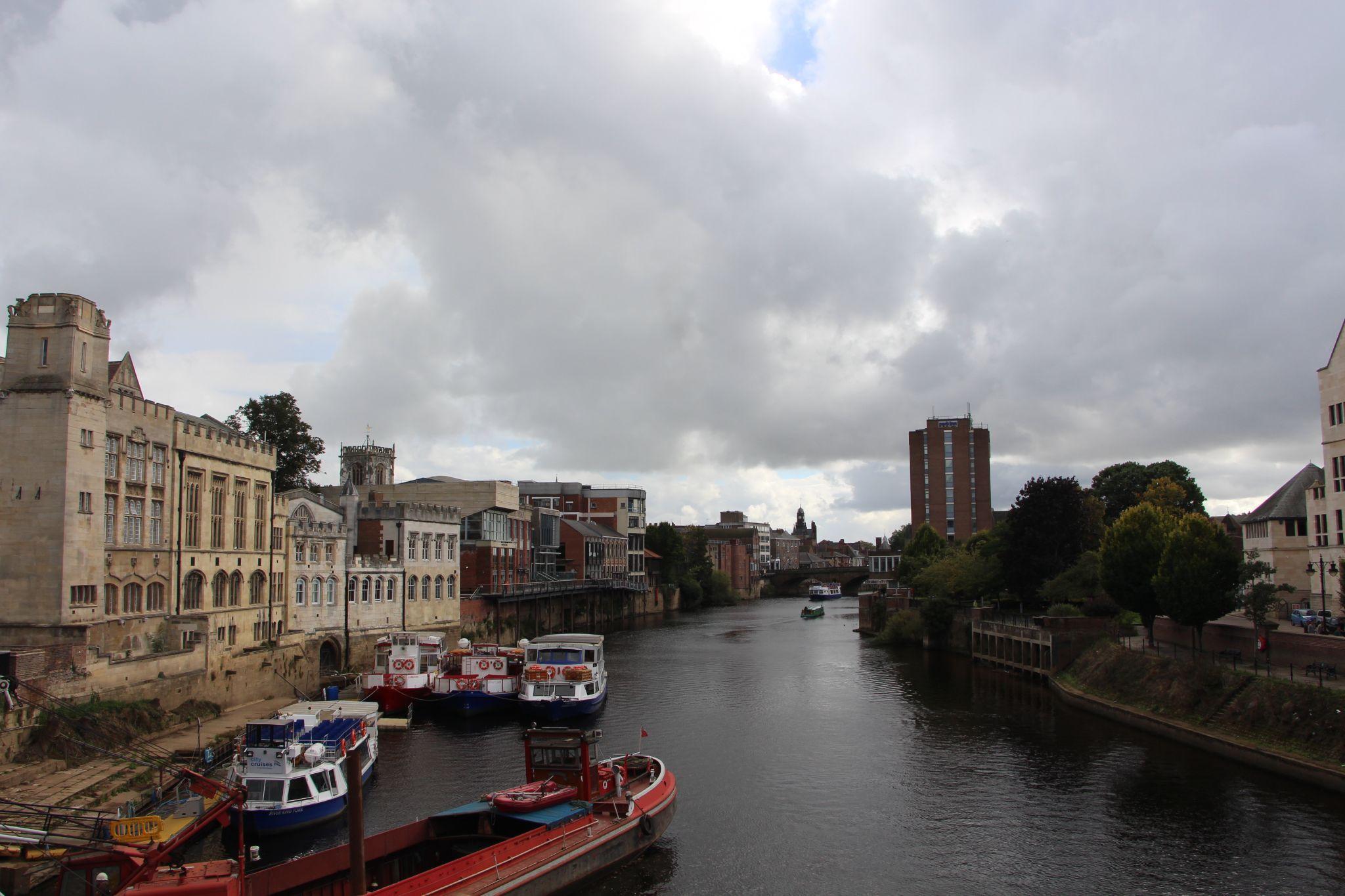
The Ouse and the Foss, the two rivers of York, have very different characters. The Ouse is the principal river. It is much the wider, used by pleasure craft, crossed by major bridges and lined with parks, public walks, quaysides and significant buildings such as the Guildhall. By contrast the Foss is much narrower, no longer navigable.
HOW LONG ARE THE RIVER OUSE AND FOSS?
The River Ouse is 52 miles (84 miles) long

The River Foss is 19.5 miles (31 miles) long
The Ouse valley is a wide, flat plain; heavy rainfall higher in the river's drainage basin can bring severe flooding to settlements. In recent years York, Selby and villages in between have been flooded.
HOW MANY TRIBUTARIES DOES THE RIVER SEVERN HAVE?
There are 21 tributaries that flow into the River Severn.

The River Foss is a tributary of the River Ouse.The River Foss was dammed, and even though the elevation to the River Ouse is small, a waterfall was formed. This may have led to the name Fos which became Foss.

HOW MANY TRIBUTARIES DOES DOES RIVER OUSE HAS?
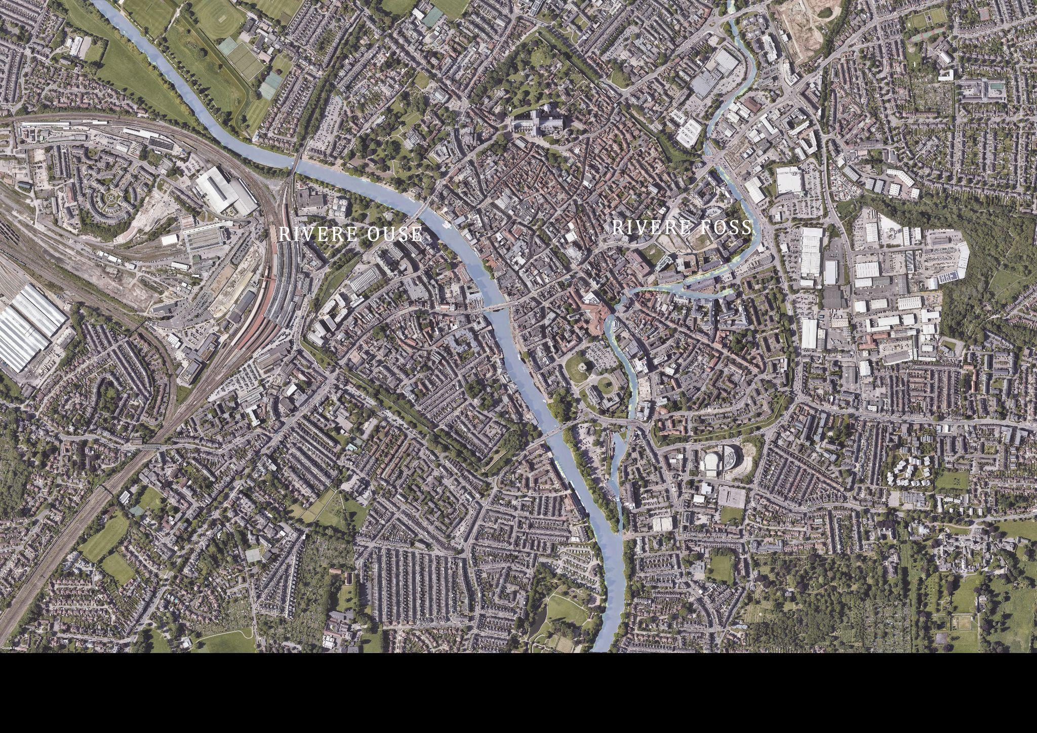
The Ouse's system of tributaries includes the Derwent, Aire, Don, Wharfe, Rother, Nidd, Swale, Ure and Foss. Together they drain a large part of the Pennines, and much of the Yorkshire Dales and North York Moors..

WHERE ARE THE SOURCES OF THE RIVERS OUSE AND FOSS?

The start of the Ouse is now considered to be the point where Ouse Gill Beck joins the River Ure, 1.6 miles (2.5 km) south-east of Great Ouseburn.
The source of the Foss is a spring in the Howardian Hills adjacent to, and flowing into, Oulston Reservoir near Newburgh Priory, four miles (6.5 km) north of Easingwold.
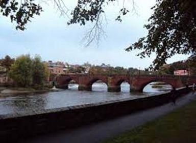
THE DEE BRIDGE

Built byr Romans, the bridge is made of red sandstone.

It consists of seven arches varying between 23ft and 60ft in span.
GROSVENOR BRIDGE
The Grosvenor Bridge is a single-span stone arch road bridge crossing the River Dee and constructed by James Trubshaw of Staffordshire.

DINHAM BRIDGE
A beautiful Stone bridge crossing the Teme in Whitcliffe Park, in the shadow of Ludlow Castle.
It was built in 1823 by Thomas Telford
LUDFORD BRIDGE
Ludford Bridge which is a three-arch Grade
I-listed masonry bridge crossing the River Teme and connects the village of Ludford with Ludlow. Built in the 15th century.


LENDAL BRIDGE
Lendal Bridge is an iron bridge with details in the Gothic style popular in Victorian England. The ornate parapet of the bridge features the white rose of York, the crossed keys of the Diocese of York and the lions of England.
OUSE BRIDGE
The oldest known site, dating to the 9th century, of a bridge spanning the Ouse is that of the current Ouse Bridge (built 1821). It was the first modern road bridge to cross the River Ouse in York.


SKELDERGATE BRIDGE
Skeldergate Bridge was the third of the modern road bridges to cross the River Ouse at York. Skeldergate Bridge, like Lendal, is an iron bridge with Gothic details. The parapet is decorated with ornate ironwork featuring trefoils, six-pointed stars and the white rose of York.
The usual range of the River Teme at Ludlow Teme is between 0.86m and 3.00m. It has been between these levels for 90% of the time since monitoring began.

The typical recent level of the River Teme at Ludlow Teme over the past 12 months has been between 0.87m and 3.35m. It has been between these levels for at least 150 days in the past year.
The highest level ever recorded at the River Teme at Ludlow Teme is 5.22m, reached on Saturday 21st July 2007 at 8:15am.
This map shows the areas of the city which have been hit by flooding and to what depth.

The River Dee catchment is obviously the area most affected but it also shows its tributaries as well as the River Gowy.


 Hedges & Waterbody
Stone Pavement
Hedges & Waterbody
Stone Pavement


 INTERVENTION 04- York by Aasif Nur Shadman


