

city of contradictions
STUDIO LEADER
STUDENT
ARCHIP
WERTIG JAROSLAV JAKUB KOPECKY
YU SAI YIU2023/2024

Hong Kong – a city of contradictions between nature and city, land and population


Prologue
Introduction to the book
Hong Kong’s urban status quo between nature and city between land and population
Hung Hom
Location in Hong Kong
Development history
Reclamation development
Traces of industry
Hung Hom & nature
Site location
Site specific issues
To be built
Current situation of residential area
Hong Kong
Residential in Hong Kong
Type of housing
Tranformation of urban grid
Urbanization development example
Keywords
Case study of Hong Kong housing
Private housing
Building regulation for G.F.A. concession
Summary of private house
Public housing
Summary of public housing
Residential should closer to nature
Project Program
Commerial appproach
Concept diagram
The edge corner of Hung Hom
Axonometric
Site plan & floor plans
Sections
Elevations
Balcony/ terrace arrangment
Facade arrangment
Materials
“we borrow from nature the space upon which we build”
Tadao Ando
INTRODUCTION
Hong Kong is located in southern China, bordering Shenzhen, with a land area of 1114.35 square kilometers and is surrounded by sea on three sides. It has rich marine resources. Through a series of historical factors, Hong Kong has developed into one of the world’s most densely developed cities, with a population of 7,498,100 people in 2023 and a population density of 6,728 people per square kilometer. In this objective environment, Hong Kong’s housing development is one of the issues that the society needs to pay great attention.
In the future, as the population continues to rise, Hong Kong will need higher-density housing to meet population needs. Today’s residential development comes at the expense of height and density between buildings, and is developed in an inverted pattern, with the ground floor used for commercial purposes and the upper floors used for commercial purposes. Residential. However, people living in Hong Kong are constantly surrounded by man-made buildings, and the city has lost the coexistence and balance with nature.
Through this project, I hope to study the relationship between high-density residential complexes and natural development to change the existing boring urban space.

HONG KONG’S URBAN STATUS QUO
Against a background with a large number of natural elements, Hong Kong’s tall buildings, residential buildings, commercial buildings, and factory buildings intersect with each other to form Hong Kong’s unique urban landscape.
Hong Kong’s urban landscape can be divided into 3 categories:
1. Among nature
2. At the boundary between city and nature
3. Among cities


among cities between city and nature

HONG KONG’S URBAN STATUS QUO
Among the above three types of urban landscapes, what is more concerning is that natural elements have lost traces in the city.
If we use a human perspective to navigate between urban areas, it is difficult for us to find large-scale natural landscapes.
This is what this project focuses on. The natural environment and housing needs are inseparable. Architecture is born because of people. As far back as the Stone Age, people lived in trees and caves, and later built houses. The uniqueness of Hong Kong It has large areas of greenary and natural elements such as the ocean. However, due to population density and residential demand, Hong Kong’s urban landscape has become only highrise buildings.
We need to find a balance between nature and high-density housing.


HONG KONG’S URBAN STATUS QUO
There is an interesting scenery in the urban landscape. Some long-developed streets are filled with various signboards without unified standards. Their respective combinations bring a messy but harmonious feeling to the streets, just like It resembles a naturally growing forest and turns the street into a space under the sign, and attach to the building.
These signs replace the role of trees in the streets and provide shade for pedestrians. It is a kind of “man-made nature”.
But now that the government has begun to regulate the size and design of signboards, this “manmade nature” is on the way to disappearing.


URBAN
BETWEEN NATURE AND CITY
Hong Kong is located in the south of China, bordering Shenzhen, with a land area of 1114.35 square kilometers and is surrounded by sea on three sides. It has rich marine resources.
Hong Kong consists of Hong Kong Island, Kowloon, and the New Territories. The developed land in these three parts is 24%. The high-density population requires Hong Kong to be highly urbanized to meet employment and housing needs.
In addition to urban areas, Hong Kong also has a large number of hills of different heights, country parks and “green belts” accounting for 67% of Hong Kong’s land area. They are distributed in different parts of Hong Kong rather than concentrated in certain areas.
Distribution of Nature and Urban Area
NATURE


HONG KONG’S URBAN STATUS QUO
As one of the world’s most well-known cities, the reason why Hong Kong has only 24% of its developed land is because Hong Kong has many and steep mountains, which are evenly distributed and difficult to develop and connect between mountains.
There is no incentive for the government to spend a lot of resources on development. So the natural features of Hong Kong are preserved and very close to the developed areas.

(above Hong Kong Principal Datum)
Tai Mo Shan
Fung Wong Peak
Tai Tung Shan
Ma On Shan
Wong Leng
Fei Ngo Shan
Castle Peak
Tai Lo Shan
Kai Kung Leng
Tai To Yan
Victoria Peak
Neelde Hill
Mount Parker
Lion Rock
High West
Nam She Tsim
Beacon Hill
Violet Hill
Tiu Yue Yung


BETWEEN LAND AND POPULATION
Since Hong Kong was ceded to Britain in 1841, it has developed from a small fishing village of about 4,000 people to an international city with ~7.5 million people in 2023. The important moments that affected the demographic transformation are reflected in the picture on the right and below:
Ceded Kowloon to Britain and incorporated British Hong Kong
Lease the New Territories to the UK for 99 years
Japan invaded China and Chinese refugees poured into Hong Kong
Hong Kong fell and Chinese refugees were deported
Japan surrenders and civil war breaks out
Famine in China, the outbreak of the Cultural Revolution, and a large number of Chinese people smuggled to Hong Kong
Implementing the barrier policy, as long as they arrive in the urban area of Hong Kong south of Boundary Street, illegal immigrants will be treated as legal temporary residents
The 64 Incident in Bejing led to a wave of immigration
Return to China
Mainland children born in Hong Kong have the right of abode in Hong Kong

8 7 6 5 4 3 2 1 0
A series of social issue led to a renewed wave of immigration.

The British Hong Kong government reached an agreement with the mainland Chinese government to allow blood-related Chinese residents to permanently immigrate to Hong Kong. Before 1995, the quota was 75 per day, and after 1995 it was 150.
BETWEEN LAND AND POPULATION
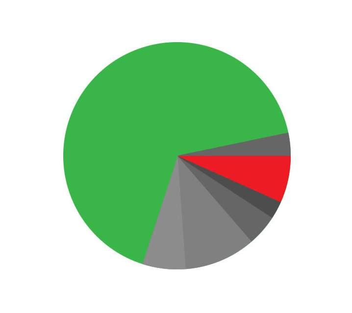
Hong Kong has a land area of 1,114.35 square kilometers, with natural environment accounting for 67% and built-up land accounting for 24%. The amount seems to be quite large, but a closer look at the land use shows that only 6.9% of the land is used for housing development. Compared with other developed cities such as Singapore (14%), London (33%), and New York (34%) are much less.
BETWEEN LAND AND POPULATION
To accommodate ~7.5 million people under 78 square kilometers, Hong Kong’s per capita living area is only ~170 square feet. High population and limited land for housing development are factors that cause Hong Kong to become a high-density city, and housing development needs attention.

As one of the most well-known cities in the world, Hong Kong has only 24% of its developed land. It also has a large number of hills of different heights, country parks and “green belts”, accounting for 67% of Hong Kong’s land area. Because these natural environments are mountainous, steep and evenly distributed, it is difficult to develop and connect the mountains. They are very close to the developed urban areas, but the living environment in the city cannot be seen due to the height of the buildings and the narrow streets. There seems to be an invisible wall between nature and urban residences, and they cannot meet. This is a contradiction that belongs to Hong Kong.
I am imagining a residential building complex that can coexist with nature. Making improvements based on the existing residential building development pattern, adding different public spaces and uses on different floors in a taller and denser building pattern It provides different viewing platforms to enjoy Hong Kong’s natural scenery.
Based on higher density development, will sunlight be blocked by buildings, can wind pass through the building, where can natural elements occur? What views does this building bring to the community when seen from different streets... etc. These issues are all considerations when designing a residential complex so that architecture and nature can coexist.

PROJECT LOCATION
From 1842 to the present, Hong Kong’s coastline has been constantly changing to meet various infrastructure and land needs. Hong Kong’s reclamation area is 78.20 square kilometers, accounting for 7% of the total area. What is interesting is the land reclaimed from the sea and the size of Hong Kong Island. The area is about the same (78.64sq.km). In addition to commercial, industrial and infrastructure uses, they also include some residential parts, such as the project location - Hung Hom.
DEVELOPMENT HISTORY - HUNG HOM

Hung Hom is the chosen site of the project, located in the southeast of Hong Kong’s Kowloon Peninsula, facing the Kai Tak Cruise Terminal across the sea to the east, and Victoria Harbor and Causeway Bay to the south.
Beginning in 1884, the Hong Kong government began to reclaim Hung Hom Bay, and the reclaimed areas were subsequently used as docks. In the early years, in addition to the shipbuilding and ship repair industries, Hung Hom also had an industry for manufacturing clay.


RECLAMATION DEVELOPMENT
Initially, only a small part of Hung Hom was land. It was not until the development of reclamation projects in the 1990s that all the original corners of the bay were filled in and the coastline was straightened. Its core area (i.e., the area around the MTR Hung Hom Station) was transformed from the ocean into residential buildings district.
In the 1980s, as Japanese and Korean companies expanded to China and Southeast Asia and set up bases in Hong Kong, the housing in the area attracted many Japanese and Korean families working in Hong Kong to rent. In recent years, there have been many Japanese and Korean shops in Hung Hom.
At present, most of the buildings in the area are residential buildings, mainly private housing estates, with a few public housing estates. A small part of Hung Hom is still reserved as an industrial area. Now the newly reclaimed land contains private housing estates, student dormitories, hotels, office buildings, funeral parlors and warehouses, etc.
1840-1849
1850-1859
1860-1869
1880-1889
1890-1899
1900-1909
1910-1919
1920-1929
1930-1939
1940-1949
1950-1959
1960-1969
1970-1979
1980-1989
1990-1999
2000-2009
2010-PRESENT


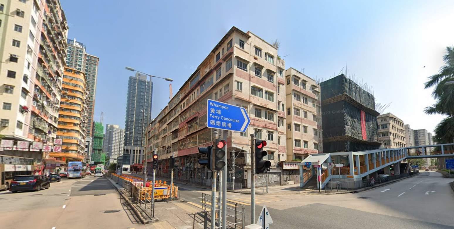
In recent years, there have been many single buildings in Hung Hom.
 HUNG HOM (ARTIFICIAL LAND)
VICTORIA HARBOUR
HO MAN TIN (NATURAL LAND)
HUNG HOM (ARTIFICIAL LAND)
VICTORIA HARBOUR
HO MAN TIN (NATURAL LAND)
HUNG HOM AND NATURE
Hung Hom is located between Ho Man Tin and Victoria Harbour, between natural land and the ocean. Most of the land in Hung Hom is now reclaimed from the sea, and the terrain is very flat. On the contrary, most of Ho Man Tin is built on small hills, like A community built based on the natural environment. Compared with Ho Man Tin, Hung Hom has no obvious relationship with nature. It is a man-made community that focuses more on the self-development of buildings, while making Victoria Harbor increasingly narrow.
The project site was chosen here as a statement to re-examine the relationship between housing and the natural environment between the manmade community environment.
In the picture on the left you can see 3 levels:
Natural land – Artificial land – Harbour


SITE LOCATION
Hung Hom’s location in Kowloon is very important. There is an undersea tunnel connecting Hong Kong Island to the south, Hung Hom also connecting Kowloon East and Kowloon West to the east and west respectively. It is a major transportation hub between Hong Kong Island and Kowloon. There is also a pedestrian foot bridge connects the Hung Hom residential area and the transportation hub. The site is the first stop connecting this transportation hub to the Hung Hom residential area. It takes about 8 minutes to walk.
Hung Hom’s metro was expanded in 2022 and connecting 2 different metro lines, and the train station will connect to mainland China. It not only brings convenience to the community, but also attracts people from outside the area to go and live. As a result, the local community has become busier and Demand for nearby housing increases.
Site
Transportation Hub
Main Traffic Road
Metro Line & Train Line above ground
Pedestrian Foot Bridge to Transportation Hub

SITE SPECIFIC ISSUES
The site is very important to the Hung Hom residential area. As the first stop from the Hung Hom transport hub to the Hung Hom residential area, the old buildings at the site have been demolished and are waiting to be rebuilt as new residential areas. The nearby buildings have different heights, counterclockwise from short to tall.
Site location serves as the entrance from the MTR line to the Hung Hom community. There is a 170-meter-high residential building on the south side, which will partially block the view. The west and north sides are used for private residences, funeral parlors and warehouses.
There are 3 blocks and a dead-end car road within the site. The car road itself serves two of the residential blocks and is mainly used for car parking and U-turns. In the new design, this road will be cancelled and become part of the building, while car parking will be arranged underground.
SITE SPECIFIC ISSUES
The site is surrounded by 4 roads, of which the southwest and northwest roads are relatively busy and are the main highways. The southeast road is a dead-end road, not busy and suitable as an entrance and exit for underground carparking. The northwest and northeast roads have a large flow of people, so they can be used as the entrance and exit of the shopping mall.
At the same time, there is a pedestrian bridge to the southwest connecting the site and the transport hub. This bridge will bring a large amount of people, and the design needs to consider how to bring these people to the ground level.
There are some green facilities on the ground level in the southeast, southwest, and west, and the site is like their meeting point.
Site Area: ~7650 S.Q.M. (85m x 90m)

TO BE REBUILT
The residential redevelopment plan of Hung Hom is ongoing to meet the needs of higher density housing and population. The original 3 blocks of 6-storey tenement buildings in the site have been demolished and are waiting to be rebuilt. The advantages of this empty site are already on the analysis above, the artificial land that has replaced the ocean; many residential buildings; developing into a higher density community. It is very suitable for the starting point of this project - the contradiction between nature and architecture, the symbiosis experiment of nature and residential complex.
Surrounding Photos of the Hung Hom Residential Zone


Residential in Hong Kong
Type of housing
Tranformation of urban grid
Urbanization development example
Keywords
Case study of Hong Kong housing
Private housing
Building regulation for G.F.A. concession
Summary of private house
Public housing
of public housing
RESIDENTIAL IN HONG KONG
There are many types of housing in Hong Kong, which we can simply summarize as small houses, private housing, and public housing estates. The median living area per capita in Hong Kong is only 16 square meters in 2021.
The small house is specially designed for the original residents of Hong Kong. It has only 3 floors and the area of each floor is 65 square meters.
There are many types of private housing, such as villas, tenement houses, single buildings, largescale development complexes, and gated communities. The current development trend tends to be dominated by large-scale development complexes. We will have detailed explanation in the “Housing Development” chapter.
Public housing estates are large-scale government development projects that emerged in the 1970s to rent out to low-income citizens. They are mainly located on the fringes of cities, making it easier to access, enjoy and respect nature than in centers.


TYPE OF HOUSING
Common residential building types in Hong Kong include the single building, block development and gated community studied above, all of which are very similar.
A single building type can easily lead to a monotonous urban space under modern planning, because the same type means that the relationship between the building and the surrounding environment is also the same, and it is easy to lose your sense of direction when wandering in the city.
This single urban appearance has replaced Hong Kong’s unique natural environment and become Hong Kong’s urban characteristics.

TRANFORMATION OF URBAN GRID
In terms of urban planning for housing, Hong Kong has several strategies. The first is to utilize the foothills of hills, and the second is to reclaim the sea.
Based on the fact that Hong Kong has more hills and less land, part of the foothills serves as part of urban and residential development. This sign is easy to find in the early development of Hong Kong Island. The higher the location of the residences, the higher the social status of the residents. The urban pattern of grid system(regular) from the flat land will slowly changes to follow the shape of the foot of the mountain(irregular).
From this urban form, we can find that Hong Kong’s urban development will be affected by the natural geographical environment.


URBANIZATION DEVELOPMENT EXAMPLE
This urbanization development example is located from Sai Ying Pun to Mid-Levels, Hong Kong Island, and contains a representative sample of Hong Kong’s “characteristics”, including forested hillsides, cascading artificial slopes, land obtained through reclamation, and urban structural tramformation from flatland to hillside.
At the same time, The urban development analysis model of Hong Kong Island reflects the shift in building density to a highrise development pattern that began in the 1970s.


KEYWORDS
In the research stage of Hong Kong’s residential, relevant searches were conducted based on the following Hong Kong’s characteristics.
Kong

At the end of 19th century, it became an international metropolis. It slowly developed from a small fishing village into a city with a high population density and urbanization level.

Hong Kong has a large amount of natural environment. Country parks and “green belts” account for 67% of Hong Kong’s land area.
High Density

The high population density has brought vitality to Hong Kong, and it has sufficient human resources. In addition, there is also a large demand for housing.
High population density and geographical factors (developed land is 24%) require a high degree of urbanization in Hong Kong to meet employment and housing needs.
Under the small living environment and high-density buildings, there is no open landscape outside the window. And usually, it will be the building opposite.
CASE STUDY OF HONG KONG HOUSING
The case study of the Hong Kong Housing will be distributed in different places and at different period in the urban area of Hong Kong, concentrated on both sides of Victoria Harbor, including Hung Hom. The case study will cover private housing and public housing to understand the existing housing and Natural relationship:
Private Housing
Building
1947 - b: 1962 - c: 1977
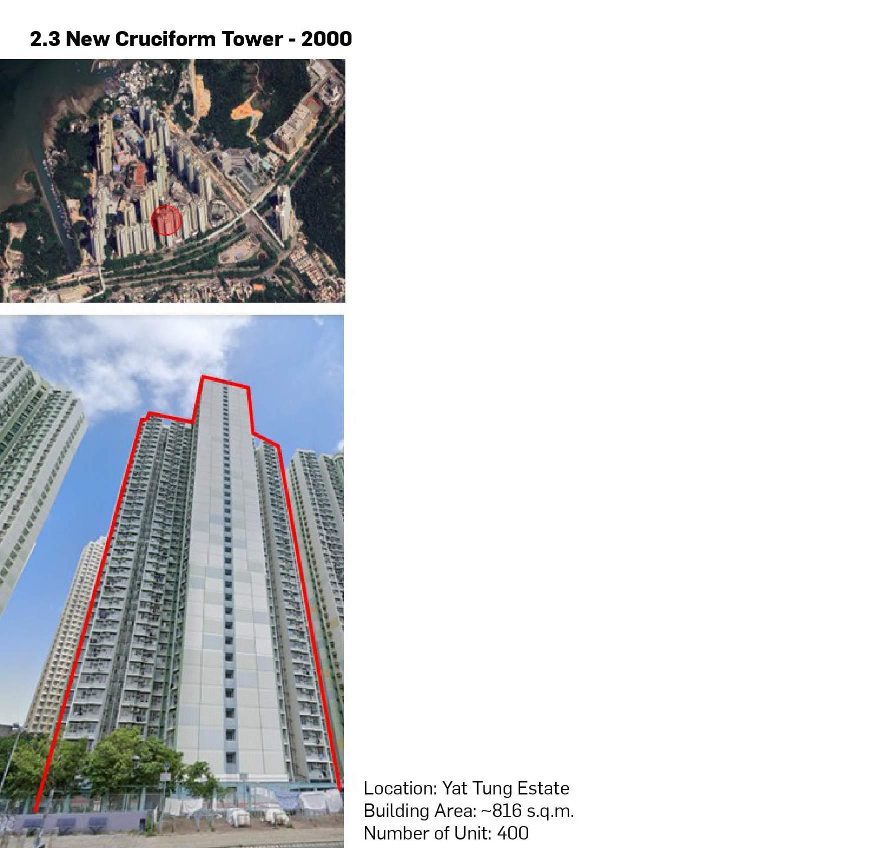
1986 - e: 2023 Block Development
1968 - b: 1983 - c: 2023
Gated Community a: 2023


SUMMARY OF PRIVATE HOUSING
The trend in private residential building is toward ever-higher densities.
Single buildings have been built since a long time ago and are still being built today. However, with the emergence of new development models such as block development and gated community, single buildings no longer dominate the market.
Block development began to emerge in the midto-late 20th century and has now become a mainstream trend in urban redevelopment.
Gated communities are mainly concentrated in the suburbs. The development in the city center is mainly due to the reclamation of the adjacent sea and the re-planning of the airport land after the relocation of Kai Tak Airport.
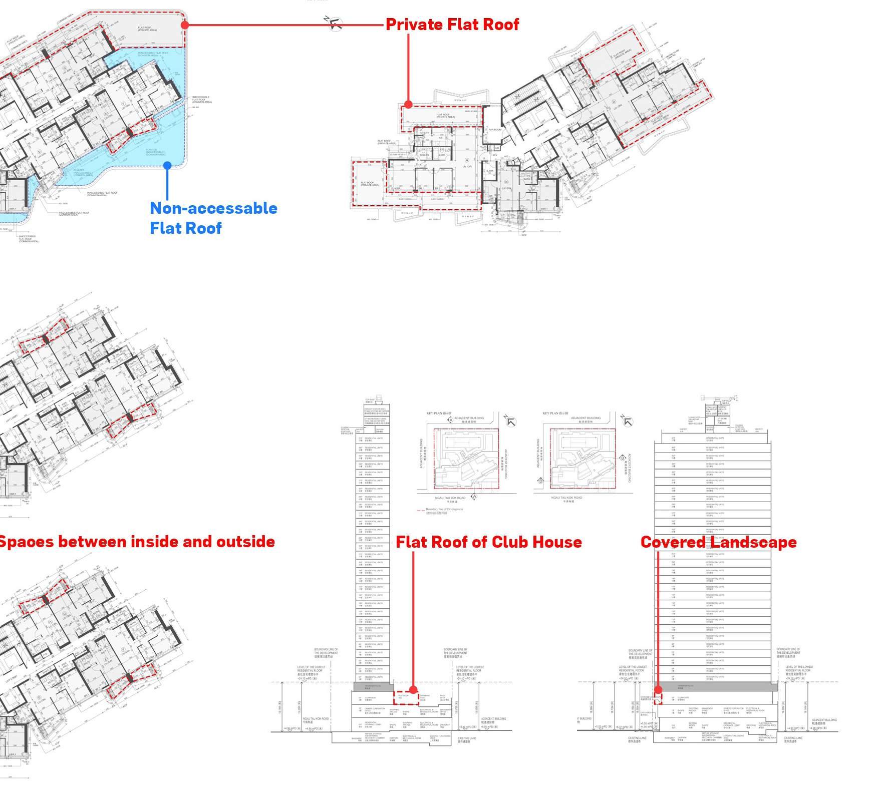
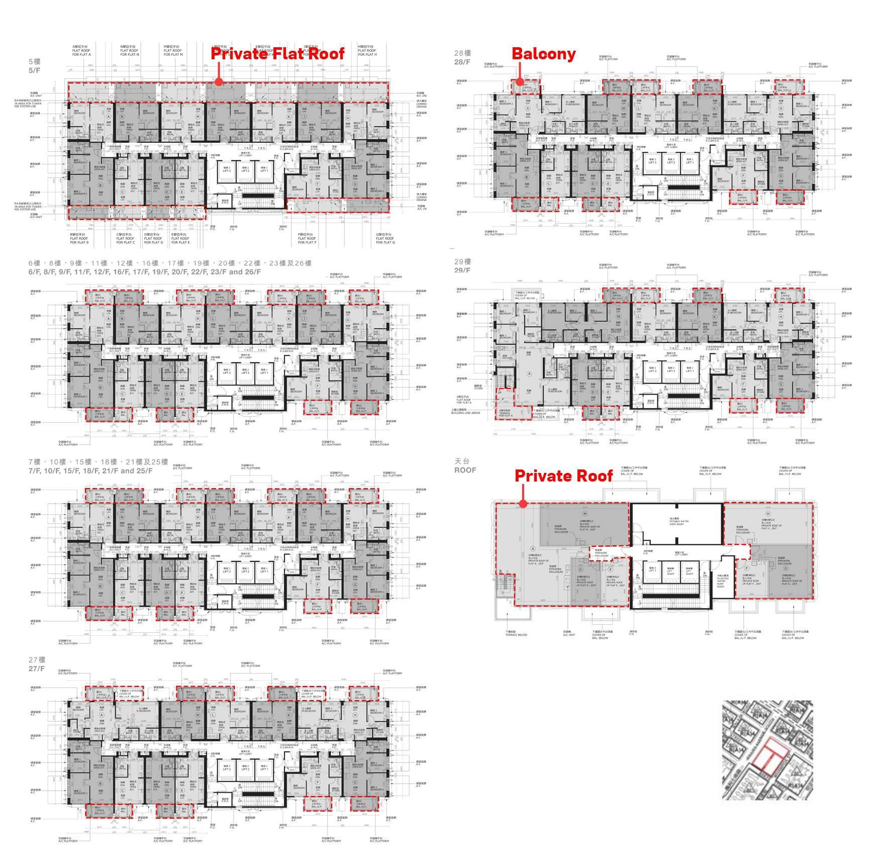
Residential buildings in 2023 all have one thing in common, they all have attached balcony to meet regulations and make more money. This greenary feature is superficial and does not really respond to Hong Kong’s natural environment.
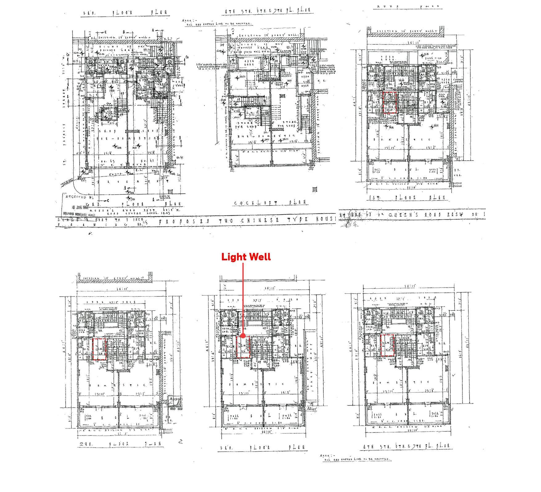
Most of the old residential buildings are crossshaped. This design method allows natural light can be obtained to meet different rooms in the unit include toilets to meet the regulations at the time.
SITE SPECIFIC ISSUES
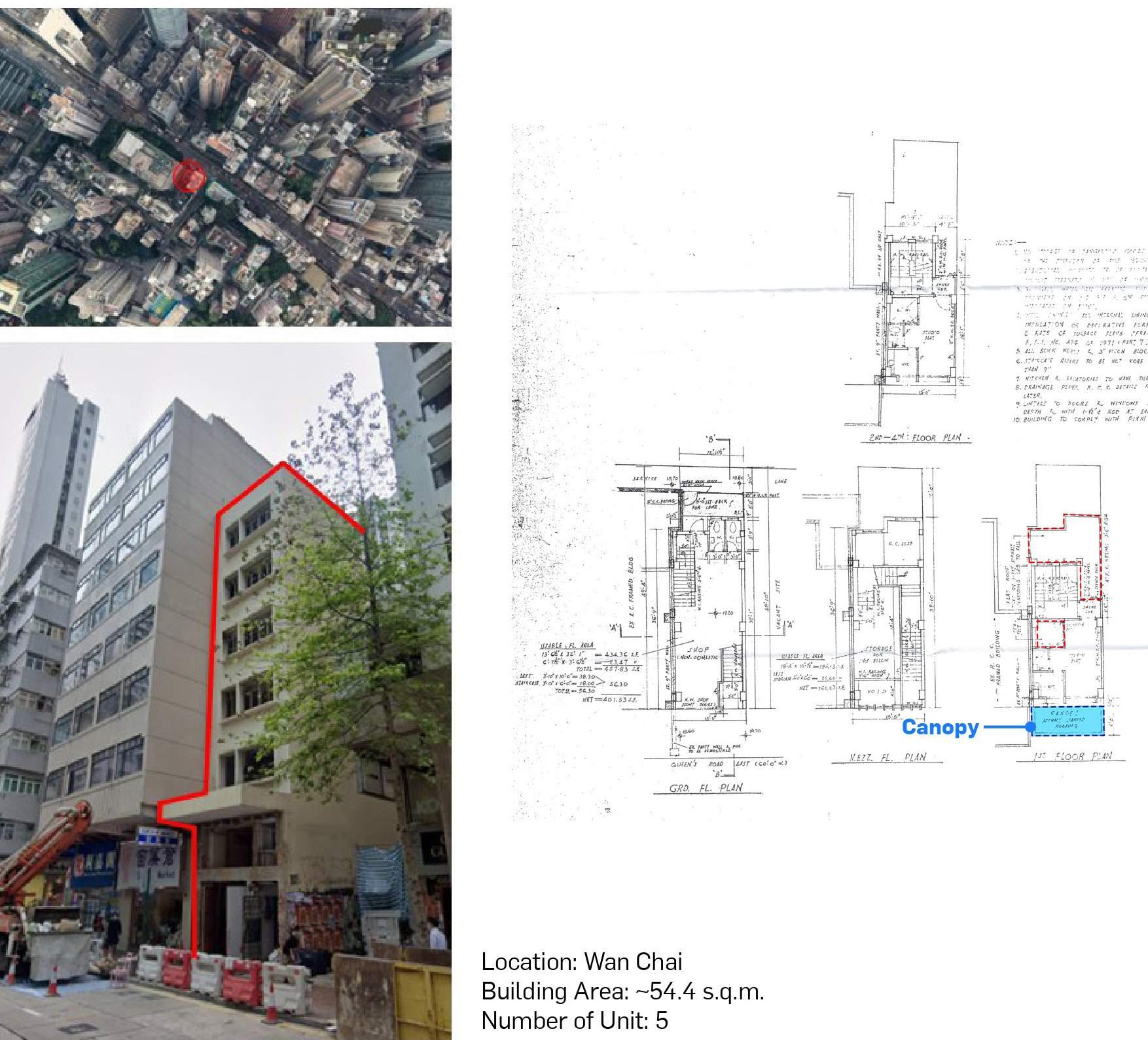
Newer and under-construction residential buildings tend to be rectangular because of the emergence of open kitchens and toilets no longer need lighting. Rectangular residential buildings can provide more units. And these 2 All kinds of common residential buildings have low-rise podiums for commercial purposes to meet the daily needs of residents.
In addition, there are some low-density tenement buildings, which are being replaced by new rectangular residences.
The cross shape have 1 core serving 6-8 units per floor. The rectangular residential have 1 core serving 9-13 units per floor, they are taller than cross-shaped residential, and provide balcony to allow residents to contact the outside environment.
Newer rectangular shape has higher density than older cross-shaped residential, and the rectangle can be extended if conditions allow. Cross-shaped houses Based on the regulations and controls on area at the time. They could not become longer. And the 2 common types lacked green facilities and public spaces on the residential floors.
The older cross shape slowly transforming into the newer rectangle, and the process of transformation between them can become the potential reapplication of the project.


SUMMARY OF PUBLIC HOUSING
Since the original housing for low-income people had many safety and health hazards, the emergence of public housing in the 1970s aimed to solve the above problems.
Public housing is mainly located on the edge of the city, with an overall layout designed in the form of an estate and being larger in size. They were easier to get in touch with the natural environment maintain than housing in the city center.
In the early days, public housing had more natural elements and limited the views outside residents’ windows. However, with more efficient design methods, public housing became smaller and smaller in paying attention to the natural environment. Instead, it focused more on smaller Land to build more units to meet population needs.


4 PROJECT
Program
Commerial appproach
Concept diagram
The edge corner of Hung Hom
Axonometric
Site plan & floor plans
Sections
Elevations
Balcony/ terrace arrangment
Facade arrangment Materials

PROGRAM
Most of the existing residential towers in Hong Kong have a common concept. The floors (podium) below 15 meters are mostly used for commercial purposes such as shopping malls. The floors above 15 meters are residential, and most of them are stacked upwards from typical floors. Most of the newer buildings are equipped with a balcony. This is because of the Hong Kong government regulations mentioned in the above study that as a green feature, the balcony can be exempted from half of the floor area.
Based on the above reasons and the residential development model of Hung Hom District, the combination of residential and shopping malls will be the subject of this design. At the same time, as the residential space in Hong Kong becomes smaller and smaller, public space will become a part of daily life in the residence. share.
Public space will become a bridge of symbiosis between architecture and nature. Green features such as balcony will complement public space and will no longer be just a tool for making money.
Therefore, the program of this project will focus on four aspects: residences, shopping malls, natural elements and public spaces, while adding some different commercial elements to ensure that this higher-density residential complex than the existing one can meet the daily needs of residences.


HOTEL
LIBRARY
FITNESS/ SPORT OFFICE
COMMERCIAL APPROACH
Depending on the site surrounding conditions such as the voice of the site environment, convenience, views, and the user’s purpose, there will be different program responses in different corners of the site:
Oiffce: The office will be arranged on the busiest road, close to the main routes of external flow, such as bus stops and footbridges connecting the transportation hub. And it is far away from the community, so people going to work will not cause much confusion to the residents of the Hung Hom community.
Fitness/sport: A good landscape matches the exercise. Facing nearby buildings is more conducive to relaxation and concentration during exercise. At the same time, the flow of people on the street is minimal compared to other corners, and people on the treadmill will not be distracted by people on the street and avoid an awkward situation for pedestrians to watch.
Hotel: The location of the Hotel is closest to the Hung Hom community, making it easier for travelers to connect with the community. At the same time, the main route for travelers to the hotel is the footbridge connecting the transportation hub. From the train/subway station, you can directly access the public platform of this building. And enter the hotel lobby located on 2/F without going through the ground.
Library: The library is located facing a relatively busy street, but library users are more focused on reading, and it is connected to the outdoor space of the inner garden.


 Outdoor garden on the first floor
Ground floor courtyard landscape
Outdoor garden on the first floor
Ground floor courtyard landscape


 Inner garden view of the office on the 7/F


