UPWEY TOWN CENTRE


Yarra Ranges Council acknowledges the Wurundjeri and other Kulin Nations as the Traditional Owners and Custodians of these lands and waterways. We pay our respects to all Elders, past, present, and emerging, who have been, and always will be, integral to the story of our region. We proudly share custodianship to care for Country together.

First Peoples are advised that this document may contain images and names of people now passed and content of cultural significance.

Upwey nestled in the foothills of the Dandenong Ranges and characterised as a foothill village, offers a unique charm
Upwey Township, nestled in the foothills of the Dandenong Ranges and characterised as a foothill village, offers a unique charm with its main shopping strip tucked away from the busy Burwood Highway arterial road while train station is directly adjacent to the Main Street.
It currently faces prolonged flooding issues behind the Main Street retail precinct, posing challenges for businesses and infrastructure. Traffic and pedestrian movements require continuous risk management to ensure safety and accessibility. Additionally, community facilities and infrastructure need upgrades to meet growing demands and modern standards, enhancing shared community value and pride
This masterplan will provide a long-term design vision that will shape future public realm development and investment in Upwey Town Centre.
Upwey is a connected and resilient village where idyllic rural setting meets a dynamic community spirit. It thrives as a hub of local culture and commerce, enriching the quality of life for residents and visitors alike.

The driving force behind this masterplan is to develop an integrated approach that aligns with the organisation’s strategy and vision for future-focused growth. It supports services and resources through a clear understanding of the community’s aspirations, needs, and culture. This masterplan seeks to address current challenges while fostering cohesive and sustainable development for the community
This masterplan document primarily focuses on enhancing the public realm, providing detailed design guidance through:
• Context analysis
• A summary of the community engagement process to date
• A community vision for the village
• Concept plans for each precinct
• Proposed materiality and planting palette
• Suggested steps for implementing the masterplan

In February 2023, a community-led workshop, supported by Yarra Ranges Council, was held to shape a vision for Upwey’s future. A key focus was understanding “what I love about Upwey” and identifying the priorities for improvements. The discussion was based around seven themes: Transport and Access, Community, Village Feel, Shops and Services, Environment, Culture and Facility.
As part of this effort, Upwey Community Plan (2023) was finalised and shared with Yarra Range Council to assist with upcoming community engagement and inform future planning.
The Masterplan is developed in conjunction with below Strategic Plans and Community Feedback
• Yarra Ranges Council Plan 2021 - 2025
• Yarra Ranges Council Recreation and Open Space Strategy
• Yarra Ranges Council, Tree Canopy Strategy 2024-2044
• Innovate - Reconciliation Action Place 2024 - 2026
• Yarra Ranges Council Gender Equality Action Plan
• Yarra Ranges Council Integrated Transport Strategy 2020 -2040
• Yarra Ranges Council Economic Development Strategy
• Yarra Ranges Council Stormwater Management Plan
• Yarra Ranges Council Parking Management Framework
• Upwey Township Masterplan Consultation Summary Report 2023
• Upwey Community Plan 2023


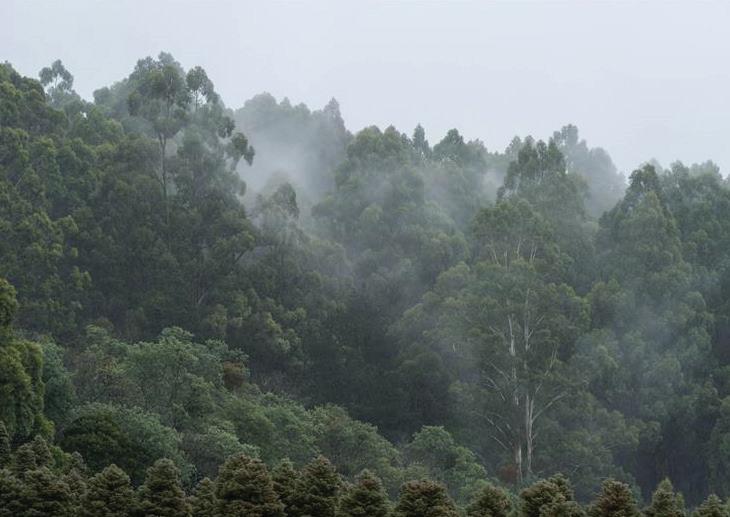
Upwey is a suburb approximately 33 kilometres (21 miles) east of Melbourne’s CBD. It sits at the southwestern edge of the Yarra Ranges Council area and serves as the foothill village to the Dandenong Ranges. Locals refer to this region as the ‘Hills,’ a series of low-rise mountains that extend further east as part of the Great Dividing Range.
Upwey’s population has grown steadily since the early 1930s. Today, it is home to nearly 10,000 residents. The suburb is bounded by Tremont and Ferny Creek to the north, Belgrave to the east, Lysterfield to the south, and Upper Ferntree Gully to the west.


Upwey’s landscape character is shaped by its diverse ecological setting, classified under Ecological Vegetation Classes (EVC) 23, Herb-Rich Foothill Forest, 18 Riparian Forest, 128 Grassy Forest, and 29 Damp Forest. This ecological richness enhances the area’s natural beauty, contributing to its distinctive green and bushland character. The presence of significant waterways, including Ferny Creek and Mast Gully Creek, adds to the environmental and cultural sensitivity of the region. These waterways play a crucial role in the local ecosystem but also contribute to periodic inundation in low-lying areas, reinforcing the need for careful land management and planning.

The town centre sits in a low-lying area just south of Burwood Highway and the Belgrave train line, with a gentle rise behind the shops leading to View Street —true to its name.
To the south, the rolling terrain forms natural vantage points, offering sweeping views of Upwey’s township and the distant low hills. This distinctive foothill landscape defines Upwey’s village character but also presents challenges for stormwater management, where localised flooding highlights the need for resilient infrastructure and sustainable water management solutions to protect the township.
Water and flooding are part of our natural environment and landscape. We aim to control and improve conditions in some rainfall events. But there is not always an engineering solution for every stormwater issue. In response to recurring flooding along the southern side of Main Street in Upwey, Council is undertaking a flood modeling and mitigation assessment to better understand how water flows through the landscape. This study will help identify areas prone to flooding and inform flood mitigation strategies.
Figure 8 outlines the Main Street study area, highlighting key flood-prone locations residential and commercial properties. It illustrates the modeled 1 in 100 year flood levels (or 1% AEP).

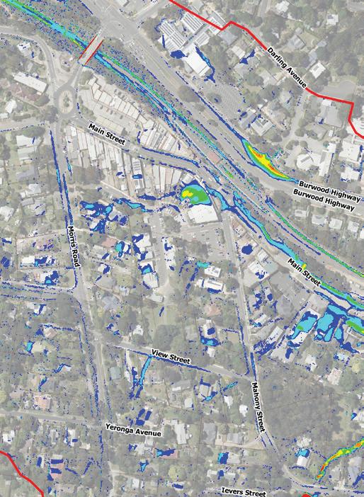
The proposed mitigation works aim to capture and redirect local runoff and overland flow toward Main Street via an open space. They will provide surface stormwater management through landscape treatment, along with an additional underground drainage system, helping to manage excessive water flows
These works align with Council’s Stormwater Management Strategy, which also focuses on
• Utilising stormwater as a resource

• Increase cross-consideration of flood mitigation and integrated water management, such as collecting stormwater to irrigate parks and open spaces, promoting sustainable water use.
• Future oriented design solution in response to climate change and maximise local cooling
• Reduce the total urban stormwater runoff volume discharge
• Decrease pollutants
This initiative is a key catalyst project in the Masterplan and will be the first scheduled works for Upwey Township.


The scope of the Masterplan encompasses the Morris Road intersection, the Main Street shopping precinct, and the Village Green—an open space with amenities located behind Main Street. It also includes the section of the Burwood Highway corridor that connects the eastern and western gateways of Upwey Town Centre. The Masterplan scope is outlined in Figure 11.
The masterplan is informed by in-depth engagement with a diversity of Upwey community groups and voices.
We received a total 222 comments for Upwey from the drop-in, letters, emails, and the the Shaping Yarra Ranges Webpage. The majority of the comments are categorised into relevant themes, then tallied and summarised as a bar chart with key explanations of the core comments below.
A number of community and stakeholder engagement activities have been held over the course of the Upwey Township Study including community meetings and engagement with community groups.
Streetscape: the comments on the streetscape highlight the need for improvements in various aspects. Suggestions include enhancements to pathway amenities, improvements in lighting, upgrades to the covered area on Main Street, and the identification of general opportunities for the overall development of Upwey Main Street.
We received a total 222 comments for Upwey from the drop-in, letters, emails, and the Shaping Yarra Ranges Webpage.
Trees & Planting: Increased planting within the Upwey Township and advocacy for more greenery, including indigenous plants, across various locations such as near the train station and the skatepark. Improved street tree planting to maximise the experience for visitors and improve the visibility of the main street.
Pedestrian Crossings & Roundabouts: Concerns have been raised about the aesthetic and dangerous conditions that are present at the roundabouts as well as the need for more frequent pedestrian crossings.
Parking: Community feedback emphasizes the importance of increased parking with the possibility for more EV parking spaces. Increased support for active modes of transport through better infrastructure and better connections to alleviate pressure on parking spaces for those that need them.
Maintenance: Community feedback highlights concerns about the maintenance of landscaping, particularly in the roundabout and median strips. Issues such as weed growth, graffiti, and the need for better upkeep are emphasized.
Community Buildings: Community feedback suggests a strong desire for consolidation and modernization of community facilities in Upwey. Proposals include replacing individual sheds with a centralized, multi-level community center, incorporating features like an amphitheater and community garden.
In late August 2023, Council launched predesign engagement to seek community insights into the issues and opportunities that are present in Upwey. One of the key drivers behind the Upwey Town Centre Masterplan was the growing community demand for improvement in and enhancement of public spaces. Building on insights from the Upwey Community Plan (2023), the aim is to shape the future through meaningful conversations with those who experience Upwey every day.
Toilets: Community feedback underscores dissatisfaction with the current state of public toilets in Upwey, emphasizing concerns such as poor maintenance, lack of accessibility, and unhygienic conditions.

Drainage: Community feedback highlights the concern of drainage and subsequent flooding. Appropriate flood mitigation measures are to be implemented to manage overland flow in peak rain events.
Streetscape: the comments on the streetscape highlight the need for improvements in various aspects. Suggestions include enhancements to pathway amenities, improvements in lighting, upgrades to the covered area on Main Street, and the identification of general opportunities for the overall development of Upwey Main Street.
Trees & Planting: Increased planting and advocacy for more greenery, including indigenous plants, across various locations such as near the train station and the skatepark. Improved street tree planting to maximise the experience for visitors and improve the visibility of the main street.
Pedestrian Crossings & Roundabouts: Concerns have been raised about the aesthetic and dangerous conditions that are present at the roundabouts as well as the need for more frequent pedestrian crossings.
“Add in one big Community Hall and remove all the individual sheds”
“Love the village feel, and beautiful shops and cafes!”
Parking: Community feedback emphasises the importance of increased parking with the possibility for more EV parking spaces. Increased support for active modes of transport through better infrastructure and better connections to alleviate pressure on parking spaces for those that need them.
Maintenance: Feedback highlights concerns about the maintenance of landscaping, particularly in the roundabout and median strips. Issues like weed growth, graffiti, and the need for better upkeep are emphasised.

Community Buildings: Feedback suggests a strong desire for consolidation and modernisation of community facilities in Upwey. Proposals include replacing individual sheds with a centralised, multi-level community center, incorporating features like an amphitheatre and community garden.
Toilets: Feedback underscores dissatisfaction with the current state of public toilets in Upwey, such as poor maintenance, lack of accessibility, and unhygienic conditions.
Drainage: Feedback highlights the concern of drainage and subsequent flooding. Appropriate flood mitigation measures are to be implemented to manage overland flow in peak rain events.
Targeted consultation took place from August 2024 to April 2025 and included meetings and workshops with:
• Members of the Disability Advisory Committee (DAC)
• Upwey Community Group
• Upwey High School (Years 7–12 cohort)
• Sherbrooke Foothills Historical Society
• Upwey Girl Guides Group
• 1st Upwey Scouts Group


• Upwey Men’s Shed
• Sherbrooke U3A Group
Their feedback provided valuable insights into the inner workings of Upwey Township and how it can better support businesses, organisations, community groups, and service providers.
The workshops focused on identifying key opportunities and constraints under core themes. The main issues that emerged during consultation have directly influenced the draft Upwey Town Centre Masterplan and are summarised into five core principles, which underpin the vision of “Village Feel” outlined in the Place Principles on page 32


Upwey
is made up of four precincts each with unique characteristics
The Masterplan has identified four precincts, each with their own unique character and function.
A critical traffic node transitioning from the high-speed Burwood Highway into local roads. It serves as a key gateway into Upwey Village, shaping first impressions and movement flow
A vibrant commercial zone featuring a mix of retail, including cafés, restaurants, specialty shops, and services. The streetscape is the primary focus of this precinct, serving as the true heart of the village.
A large open space behind Main Street, featuring playgrounds, community buildings, car parks, and parkland to the south, serving as the backbone of Upwey Village.
Acts as both a barrier and a connection between Upwey Town Centre and the recreation reserve and neighbourhoods to the north. As a major transport corridor, it also has the potential to enhance links between Upwey and neighbouring townships ( Belgrave, Upper Ferntree Gully).


• Morris Road Bridge to Roundabout is lack of a clear Upwey Village gateway statement to define the town’s identity.
• The roundabout intersection poses a significant risk to pedestrian safety.
• Insufficient safe footpath connections in the area, limiting accessibility and walkability.
• On-street parking and all-day parking provision
• Pedestrian crossings and safety
• Outdoor dining, seating and streetscape improvements
• Issues around street tree locations and canopy health
• Flooding in low-lying areas on the eastern side of the street
• Public amenities lack a safe and well-connected pedestrian linkage from Main Street to the reserve
• Limited passive surveillance reduces safety and visibility
• Car-dominated precinct weakens pedestrian connectivity and impedes potential for more open space
• A group of community halls and a public toilet with potential for upgrade and integration
• Burwood Highway is an arterial road (70 km/h) and a major barrier dividing north and south
• Pedestrian crossing improvements to the existing underpass and a proposed signalised intersection at Chosen Avenue and Main Street
• Improvements needed to Belgrave Rail Trail to support active transportation


The Upwey Town Centre offers a range of services and retail options to offer the community, primarily concentrated in the Main Street Shopping Precinct. The outdoor seating space provides active street interface and economic benefits.
Within the Village Green, there are some key community facilities, including a public toilet, skate park, playground, and community halls. However, the playground’s location—situated between two buildings and bordered by a driveway and car parks—poses an ongoing safety hazard for children and families.
There are five community halls in the Village Green Precinct :
• Blue Hills Centre (Senior Citizens Centre)
• Upwey Girl Guides Hall
• Upwey Townhip Hall
• Upwey Scout Hall
• Upwey Men’s Shed
Each building operates independently, offering kitchen and toilet facilities to accommodate various community groups at different times throughout the day and week.
However, feedback from key leaseholders indicates that many of the buildings are not fit for purpose and limit their operational needs. Challenges include ageing infrastructure, asbestos risks that restrict upgrade potential, and a lack of modern technology to support classes and meetings.
The fragmented and disconnected buildings across the site creates barriers to movement and sightlines, reducing opportunities for passive surveillance and limiting community integration.
Currently, all buildings are on Council-owned land, however the Scout Hall has a history of the Scout building being a Scouts Victoria owned asset.
The age of the buildings means there are limitations on how long interim improvements can continue before significant renewal investment is needed. This presents both challenges and opportunities in developing a long-term vision for optimising these buildings.
This masterplan presents a future-oriented vision for an integrated community facility that not only accommodates existing user groups and functions, but also responds to the ongoing and growing demand for accessible, fit-for-purpose community spaces. (See page 44)


In the Main Street Precinct, there is no pedestrian crossing at the upper end of Upwey Main Street, near the Morris Road intersection. On the eastern side of Main Street, where the crossing connects to the train station underpass, poor nighttime lighting creates safety concerns, and there is no pedestrian crossing between the bus stop and the station. Additionally, the existing footpaths on both sides of Main Street contain multiple trip hazards.
The pedestrian connection from the car park next to IGA to the Main Street shops is extremely unsafe. The car park driveway is shared with IGA loading dock and a narrow footpath, further hindering the pedestrian-friendly streetscape.
In the Village Green Precinct, the area between the playground, stakepark and the reserve on View Street is heavily car-dominated and lacks a continuous pedestrian link, further impacting accessibility and walkability.

The railway underpass is one of the few pedestrian-prioritised crossings on Burwood Highway; however, its lighting and overall presentation require improvement.
The Belgrave–Ringwood Rail Trail runs along Burwood Highway in the Upwey section, but the limited space creates an unsafe and compromised shared-use experience. Additionally, the linkage between the rail trail and the town centre is not well established and feels unsafe, further impacting accessibility.


Upwey town centre has a unique setting where the train station directly connects to the heart of the town centre, presenting a strong opportunity to integrate various transport modes. Enhancing this integration will improve connectivity, safety, sustainability, and overall community well-being.
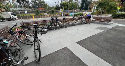
Currently, two bus routes run through Main Street and both roundabout intersections. The Belgrave Rail Trail in the Upwey section is located on the north side of the railway line but lacks a direct connection to the town centre. Strengthening this connection, along with providing improved bicycle facilities within the town centre, would encourage more cyclists and enhance active transportation options. Establishing safe and convenient cycling links between key destinations, such as the train station, shops, and surrounding residential areas, would further support sustainable transport choices.
Parking shown in the Masterplan Study Area is made up of public off-street parking, on-street parking, and privately owned off-street parking, primarily concentrated around Main Street and the Village Green precinct.
In 2024, Council conducted a parking study to capture total parking capacity in Upwey Town Centre is estimated around 300 spaces (including unmarked spaces), average occupancy is maximum at 80% throughout the week and weekend. However, feedback from stakeholder engagement and community consultations has highlighted significant pressure on parking. The key issue is the lack of all-day parking in the vicinity of commercial area, leading to conflicts between commuters, staff, business owners, and customers in general. Given these challenges, there is an urgent need to assess the current parking facilities in Upwey, review and update parking restrictions to better meet community needs.


Five core principles to guide future place-based work in Upwey Town Centre.
A holistic design and analysis process has been undertaken to understand the characteristics of the Village to inform the Masterplan concept.
To address the challenges and enhance the ‘Village Feel’, a series of actions/ projects have been identified.
The five place principles are:
• Community
p Qualities: safe, pride, The Village Feel, welcoming, clean, stewardship
p Focus areas: lighting, maintenance, meeting spaces, street furniture and event spaces
• History and Culture
p Qualities: stewardship, diverse, truth, eclectic, vibrant, heritage
p Focus areas: event spaces, art installations, yarning circle and interpretive signage
• Environment
p Qualities: thriving, maintained, resilient, attractive, shade, sustainable
p Focus areas: parks and open spaces, stormwater management, and street trees
• Facilities and Services
p Qualities: inclusive, inviting, accessible, flexible, fun, active
p Focus areas: universal access, train underpass, public transport, community buildings, playground, skatepark, and public toilets
• Accessibility and Inclusion
p Qualities: safe, connected, walkable, convenient, wellbeing, inclusive
p Focus areas: lighting, footpaths, crossings, roundabouts, parking, wayfinding and universal access


Key Design Objectives:
• Improve pedestrian connectivity
• Improve road safety
• Strengthen the sense of arrival at Upwey Village

Raised pedestrian crossing
Reshaped roundabout with a new landscaped center, enhancing the entrance to Upwey
Kerb outstand and bicycle facility
Proposed paved parklet( Sit, Meet and Eat Space)
Proposed footpath and planted buffer
on-street group
nook
Proposed paved parklet( Sit, Meet and Eat Space)
Proposed street tree with permeable paving
Proposed on-street group seating nook
Upgrade the IGA forecourt with bespoke street furniture, landscape treatments, and public festoon lighting
Raise pedestrian crossing
Resurface footpaths with new materials and patterns to ensure consistency with the surrounding streetscape
Improved access to the train station underpass with a new alignment and a potential public art installation in collaboration with the community Formalise


Key Design Objectives:
• Improve pedestrian connectivity
• Increase tree canopy coverage for better shade and streetscape
• Activate street frontages to enhance vibrancy
• Enhance accessibility for all users


Note: this represents the design intent and is conceptual only, and may inform future detail design
Key Design Objectives:
• Enhance pedestrian connectivity to create safer, more accessible walking routes
• Improve stormwater management to reduce flooding risks and enhance environmental sustainability.
• Increase safety and accessibility for all users, ensuring an inclusive and welcoming space
• Optmise community infrastructure to better serve diverse user groups and support local activities.
• Maximise open space usability for recreation, events, and everyday community use
Community Recreational and Activity Space
Existing Condition


A central pedestrian connection is a vital element in improving the Village Green Precinct, anchored by the proposed Village Square. The space provides additional seating and gathering spaces, integrated with stormwater management and landscaping, and features a flexible design to accommodate markets and community events.
The existing playground will be relocated to a less constrained area within the reserve, offering improved natural shade and access (see page 44)
Permeable paving
Picnic seats and tables
Lawn area with garden beds and trees
Dry creek bed for stormwater and sensory play
Sensory/musical play elements Festoon lighting and Gallery Wall (building facade)


Note: this represents the design intent and is conceptual only, and may inform future detail design
The proposed integrated community facility will feature a range of flexible, multi-use spaces, including function rooms, multiple meeting rooms, an activity/sports hall, shared co-working areas, and a makers’ space equipped for tools and workshops. It will also incorporate new accessible public toilet facilities. The design allows for the inclusion of a Council Community Link front desk service, ensuring the facility is staffed and able to provide on-site support and assistance to the community.
A new car park will be provided with accessible parking bays, pedestrian connections, and an expanded passive recreation lawn area for youth activities and community events.
Further investigation and consultation will be carried out to review and inform the final proposal and detailed design.
Community Recreational and Activity Space
Integrated Facility
Community Halls and Public Toilet (Ground Level footprint)
Raised pedestrian crossing with vehicular bollards (Shares Zone)
Community Hub Forecourt
New Integrated Community Hub with a front desk, multifunctional rooms, and hire-able spaces
Public toilet integrated into the Community Hub with external access
The forecourt garden integrated with the existing Yarning Circle, offering more picnic opportunities
Lawn area with canopy trees, seating, and a youth activity node
New playspace with picnic settings.
Communal social node with shelter and seating opportunities
Informal stage and amphitheatre for community gatherings and events
New car park with footpath connection and passive infiltration garden bed (44no. parking bays)
Others (driveway, laneway, services, off-limits area, ramp and stairs):


Note: this represents the design intent and is conceptual only, and may inform future detail design
View 4 : Artist’s impression of Integrated Community Hall

Note: this represents the design intent and is conceptual only, and may inform future detail design
Key Design Objectives:
• Enhance pedestrian connectivit
• Increase road safety
• Create a stronger sense of arrival at Upwey Village
• Improve the cycling route for better integration with transport network
Widen the existing Belgrave Rail Trail to improve safety and shared use
Proposed ramp connection to link the drop-off and landing space with the footpath, rail trail, and underpass access.
A new bus stop with an indented bus bay, integrated with the bus replacement location and drop-off area
Upgrade the intersection by removing the slip lane and installing traffic lights
Reclaim the slip lane for road reserve, incorporating a new footpath connection, garden beds, and tree planting. A potential public art installation in collaboration with the community
Install a signalised pedestrian crossing to improve accessibility and safety
stop with an indented bus bay


A cohesive design palette to enhance the ‘village feel’ of Upwey


and use Bird attracting, feature flowers, pollinator attracting
display, feature foliage, winter sun, feature flowers Feature flowers, summer deciduous, shade, bird attracting

The masterplan will be delivered over time as the funding becomes available


These projects have been proposed, and assessed at a concept design level and the costings, in turn, reflect the high level nature of these estimates that have been generated through comparison projects and square metre rates.
[Disclaimer - The costs included in this section of the report are indicative rates calculated at the time of the design and does not take into account future price increases or decreases. Proper detailed cost estimates are to be undertaken for each individual project immediately prior to seeking any formal budget.]
1 Upwey Town Centre Flooding Mitigation Project
Prepare detailed stormwater catchment analysis, provide detail design and construction focusing on improvement of the existing flooding impacted area including kerb & channel installation, provision of overland flow path and Civil and Drainage Works for Village Square ( Existing Playground Reserve)
2 Village Square Following the Flooding Mitigation project, the overland flow path (currently the existing playground Reserve) will be redeveloped into Upwey Village Square. The redevelopment will include:
• Permeable surfaces
• Additional garden beds and tree plantings
• Outdoor seating
• Festoon lighting
• Sensory based play elements
3 Upwey Town Centre Playspace Relocation
Relocate the existing playspace to the proposed location to accommodate stormwater overland flow requirements. Improve the safety and inclusivity by providing improved access, inclusive play equipment, and new adjacent footpath connections to existing infrastructure in Upwey.
4 Road Safety Improvement Upgrading the Morris Road & Main Street intersection and Mahony Street & Main Street intersection, including the installation of new raised pedestrian crossings on each approach and new landscape treatment for Morris Road roundabout. The project also includes one of the proposed Sit Meet and Eat space directly adjacent to the crossing.
5 Upwey Main Street Revitalisation Design and construction of Main Street Streetscape Upgrade including:
• New street tree planting with porous paving
• Installation of 1no. Permanent Sit, Meet and Eat Space
• Resurface footpath
• Outdoor group seating nooks (including IGA forecourt)
• Festoon lighting
6 Car Park Improvement ( next to IGA)
Modification of the existing car park entry and provision of designated loading zone for IGA
Design and Place (YRC)
Design and Delivery (YRC)
and Place (YRC)
Design and Delivery (YRC)
- Design and Place (YRC) - Infrastructure Services (YRC)
- Design and Place (YRC)
- Infrastructure Services (YRC)
- Design & Place (YRC) - Infrastructure Services
Conduct a car park assessment and report around Upwey Town Centre to update current parking restrictions within the township and address evolving demands.
the
• Lawn area with seating space
• New car park
• Lighting
Youth activation nodes
• Informal amphitheater
• Garden bed with new tree planting
12 Community Hub Review and optimise the existing community sheds including: undertaking full scope of building surveying and report
Provide architectural design for integrated community hall.
13 Burwood Hwy Intersection
Parks and Facilities (YRC)
- Vic Track (VG)
*Note: The price shown excludes demolition costs and allowances for unknown contingencies - Design & Place (YRC)
Signalise the intersection including
• Removal of the right hand turn split lane
• Installation pedestrian crossing
• Reclaimed road reserve with new landscape treatment
- Design and Delivery (YRC)
Exclusions:
• Excludes anticipated State Government subsidies.
• Excludes upgrading of existing services other than services clarifies in the cost plan.
• Excludes Goods and Services Tax (GST). Timing terms:
• Short = 1 5 years
• Medium = 5 10 years
• Long = 10 20 years
- Design & Place (YRC)
- Infrastructure Services (YRC)
- Department of Transport and Planning (VG)
Total anticipated implementation budget: $9.8M to $10M
Council recommends anyone having difficulties viewing or interpreting elements of this document due to accessibility needs to contact us for assistance
Published MARCH 2025
© Yarra Ranges Council 2023 ABN: 21 973 226 0120
15 Anderson Street, Lilydale PO Box 105, Anderson Street, Lilydale 3140
Phone: 1300 368 333
Email: mail@yarraranges.vic.gov.au
Web: yarraranges.vic.gov.au