
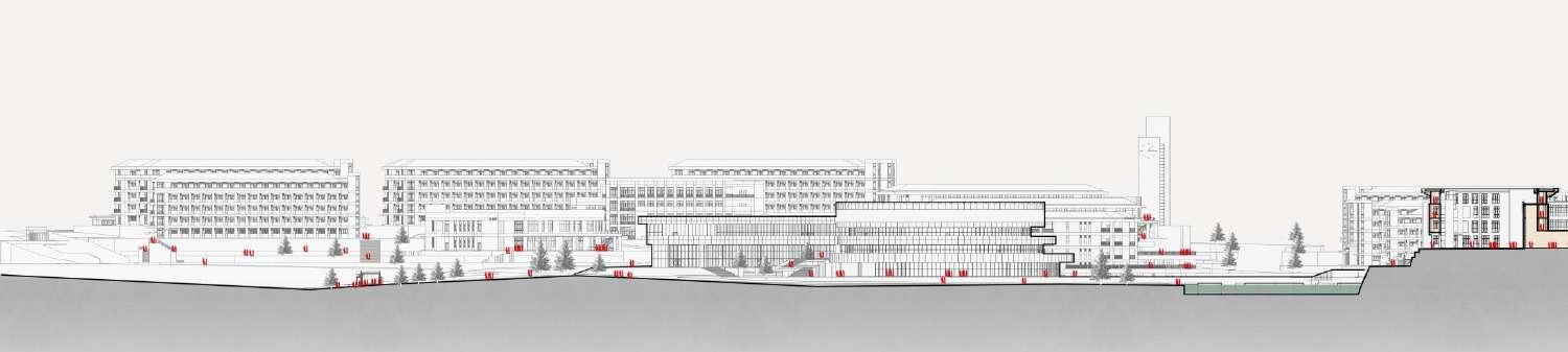
1 1 8 9 14 15 20 24 27 20 23 3 4 Contents The Cloud 6 28 30 Hydroponic Ceramic Wall 5 Case Study: Lewis Art Complex 34 35 8 City Plaza 2 Raising Community Bicycle Highway Urban Valley 31 33 7 Library and Art Gallery Complex
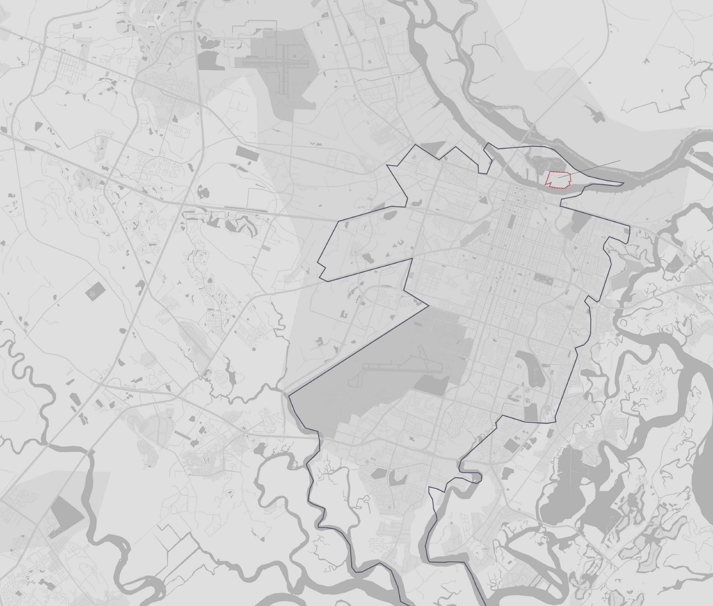
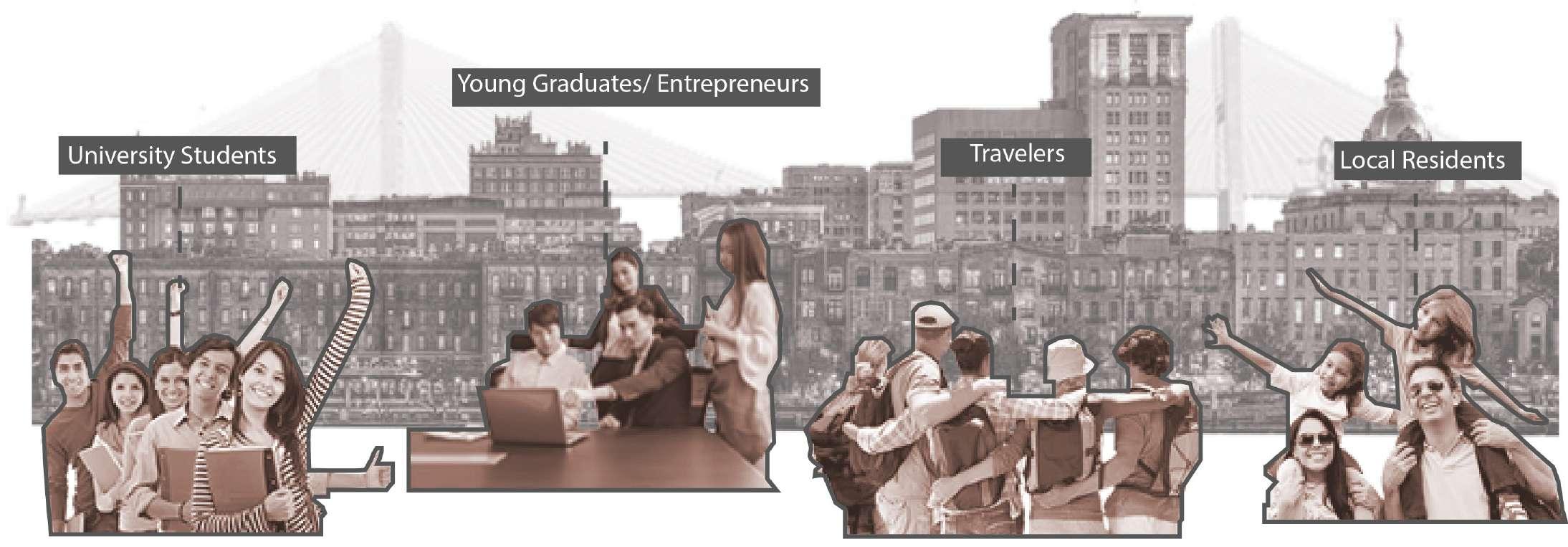
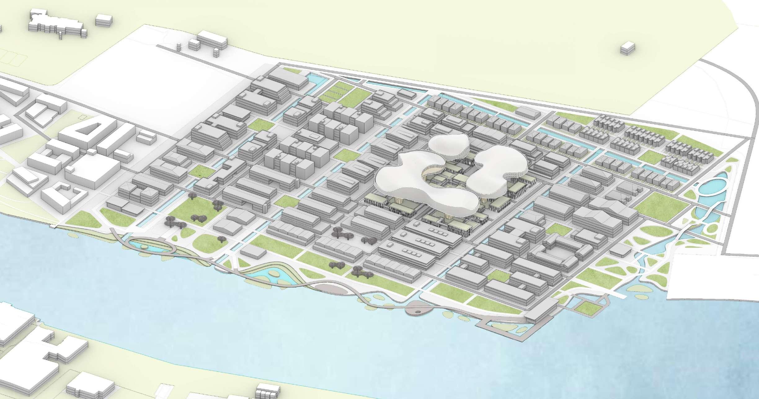
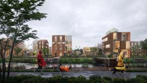
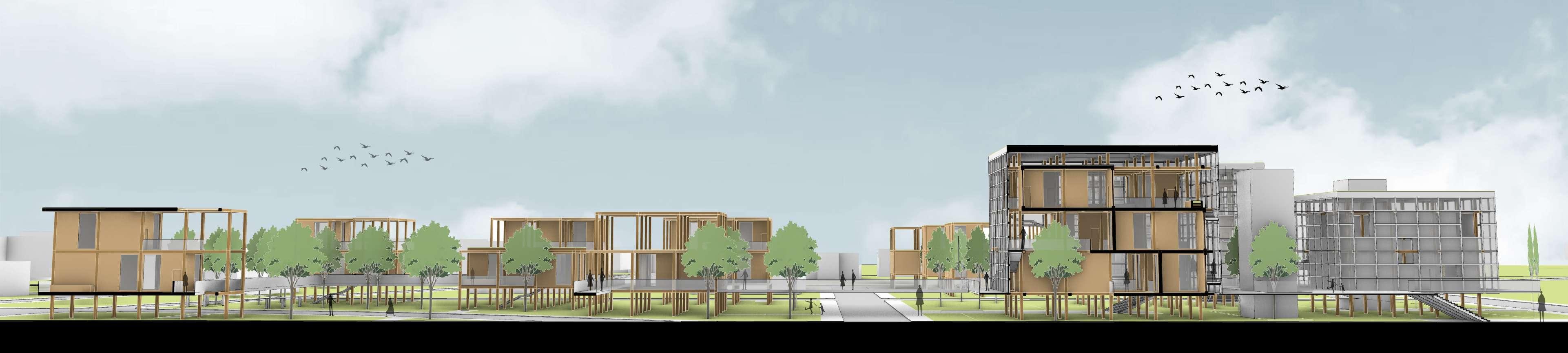
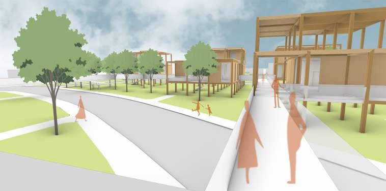
“The Cloud” is committed to providing an incubator park for the Savannah Port on Hutcheson Island, north of Savannah’s urban area, with more living and working places for local shipping companies and attracting more entrepreneurs to live and work here.
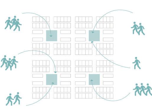
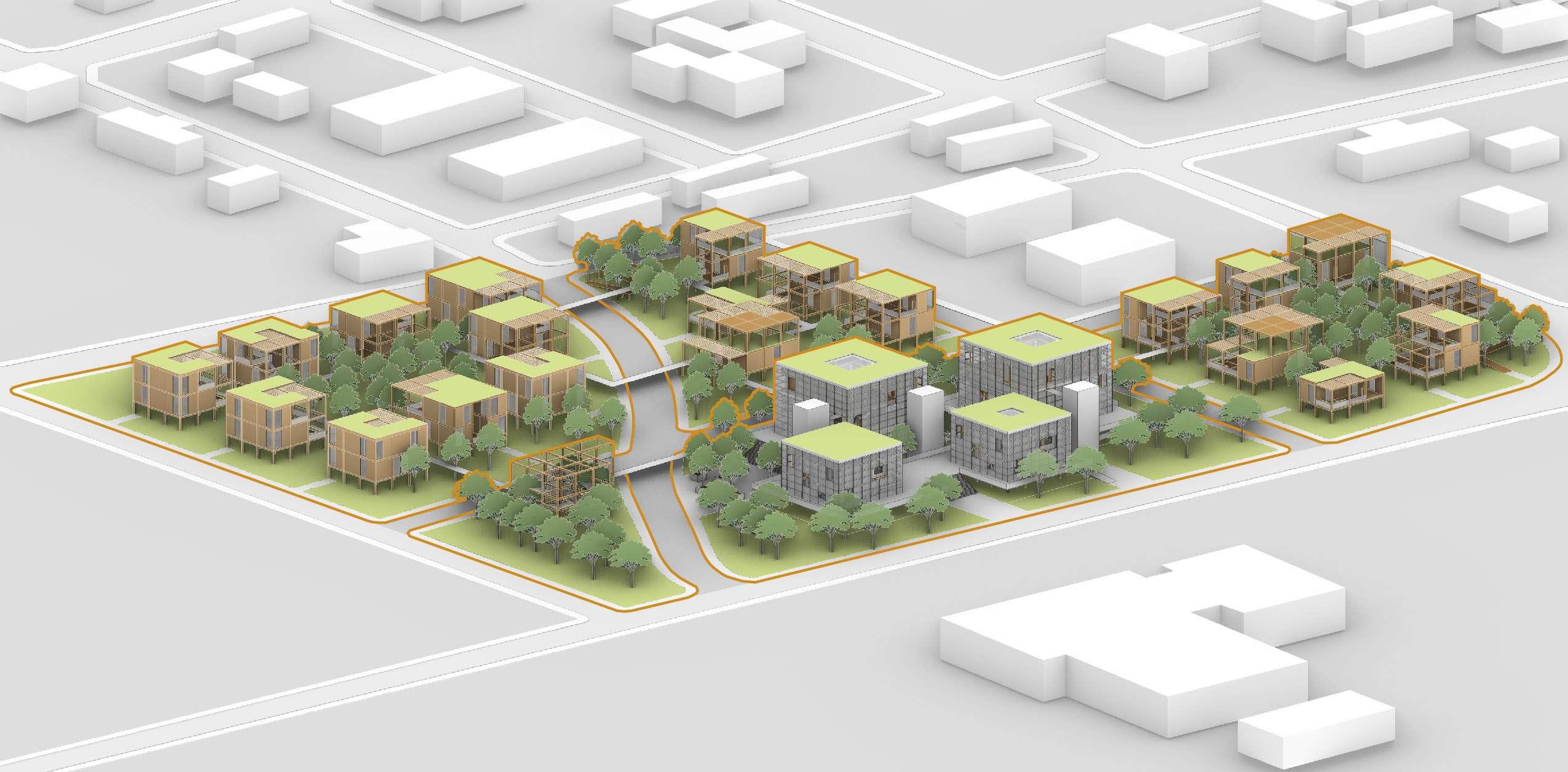
By using shape machine to analyze and reconstruct the local urban grid (Savannah Ward) of Savannah, we recognize and understand the importance of the savannah ward for local urban planning. In order to use the existing urban texture of the savannah in the design of the island technology park, our design is based on the concept of the fractal, which will reconstruct the savannah ward, thereby forming savannah wards of different sizes. With Solving the existing and potential problems of the site while inheriting the original urban texture and providing people with a variety of activity spaces.
In addition, with the continuous development of cities and the continuous progress of science and technology, people gradually realize the importance of environmental protection and energy conservation and emission reduction. As a technology park design, we designed a parametric canopy with the unique oak tree in Savannah as a design element, which is committed to the concept of sustainable development and green building, through the use of passive design strategies to provide entrepreneurs with a healthy, sustainable, and biophilic working and living environment.
 Hutchison Island, Savannah, GA
Personal Academic Work, Spetember, 2022-Decmeber, 2022
Hutchison Island, Savannah, GA
Personal Academic Work, Spetember, 2022-Decmeber, 2022

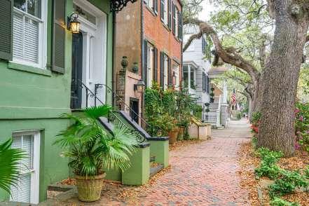
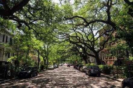
The squares and parks are the icons in Savannah. Originally designed with 24 squares, 22 remain today to be enjoyed by millions who grace their grassy utopias every year. These squares provide places for receation and entertainment for local residents and visitors.


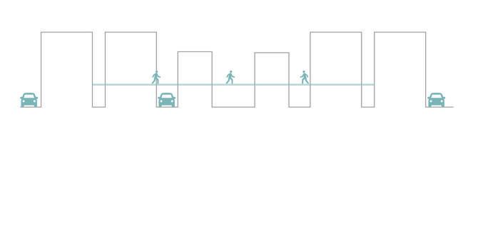
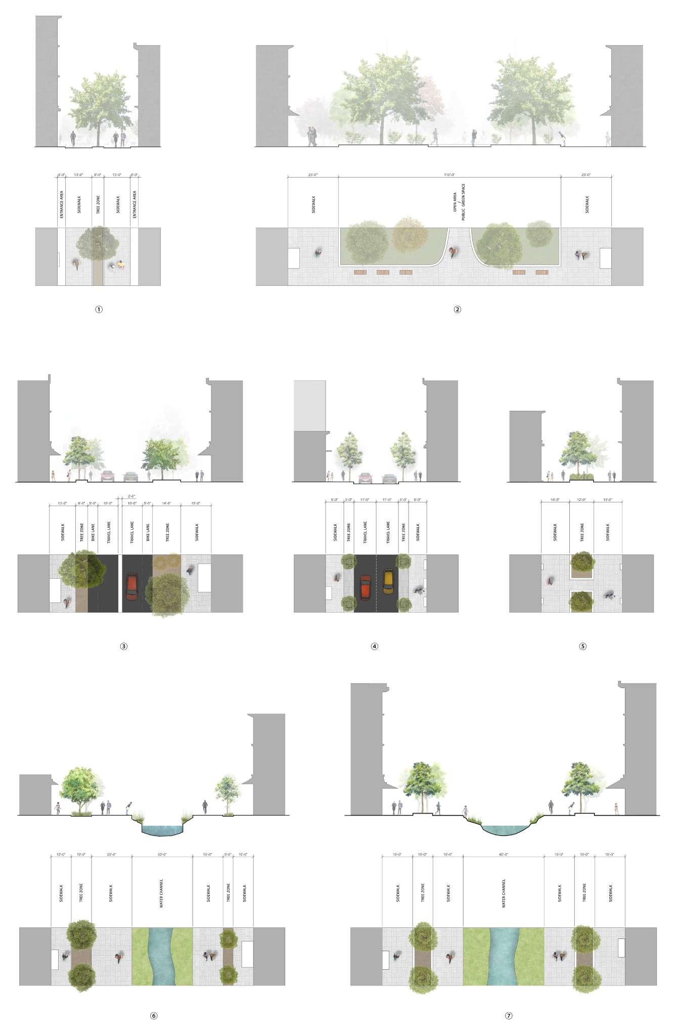
Walkability is excellent, walking in the Savannah is a pleasant experience. The combination of shops and canopies has also become a feature Savannah Street. This friendly space will engage the tourists and improvethe living comfort of residents.


The Savannah River is one of the most elements in Savannah, it is related to the lives of citizens attract tourists from all over the world. Besides, the river create the local business (shipping compaines).

2

short distance
Connectivity Greenery Space
Cross Road Multiple times in one ward

The block limits the size of the building The distance between the buildings is too narrow
Enlarge the block size while retaining the advantages of traditional grids


Provide a secondary circulation system for pedestrians


During the pandemic, park and out door space visitation increased. However, the greenery space inside the ward is not big enough for large scale and crowded events
In the future, sea levels will rise year by year, leading to potential flooding risk in Savannah
Using shape machine to divide spaces in different ways, creating different scales of spaces that can put different functions in. Such attempts allows us to conceive the construction form of grids of different scales in the city, as well as the layout of the overall texture.

1. The dna was extracted from the savannah plan as the basic shape of the road
2. The largest-scale basic form is arranged in the center of the site, which becomes the core with important function.
3. Add small-sized similar patterns around the central pattern to divide different levels of grids.

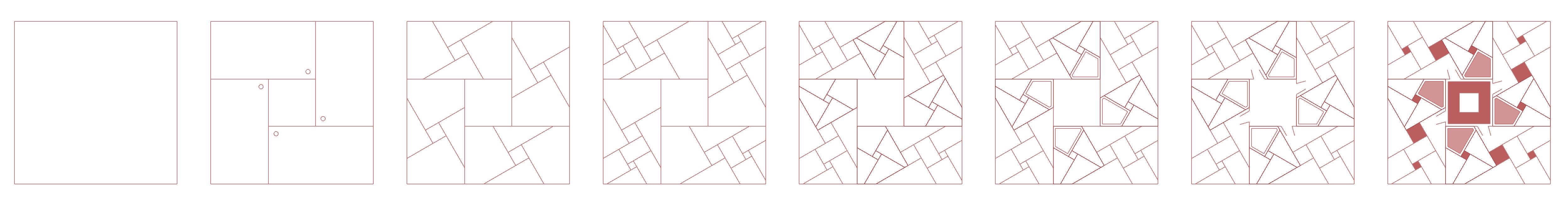
4. Add a third-level pattern to divide the overall space of the site in more levels.
Create different scales of passages.
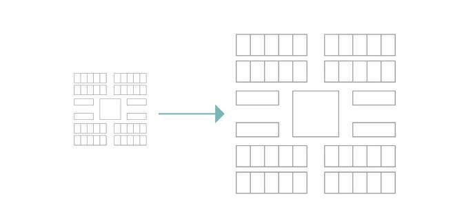
5. Add the divided fractal grid into the site, and adjust the grid considering the roads around the site.


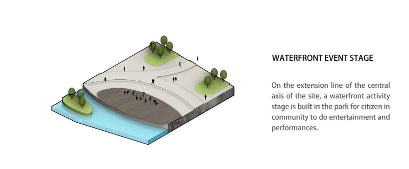
6. The center of each fractal pattern is used as an outdoor public space, and a large park is placed in the waterfront area.
7. Introduce water sources, build circulating waterways that run through the site, and design the site in detail.
8. Arrange the waterfront wetland park, lay out the buildings, and generate a relatively overall general plan.


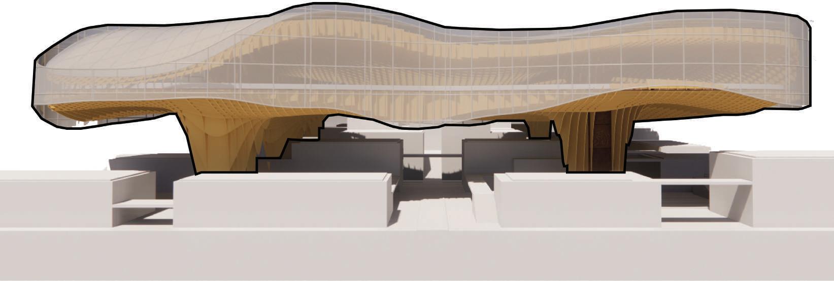


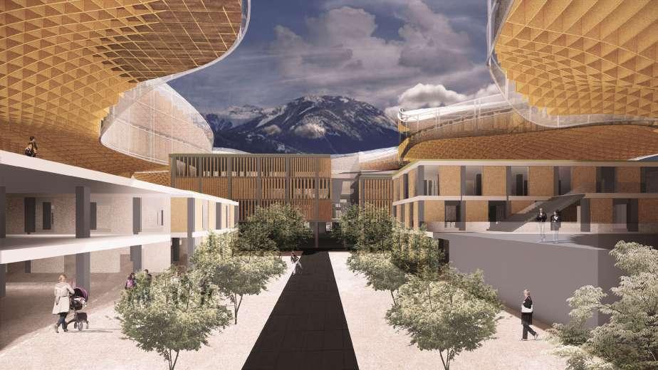
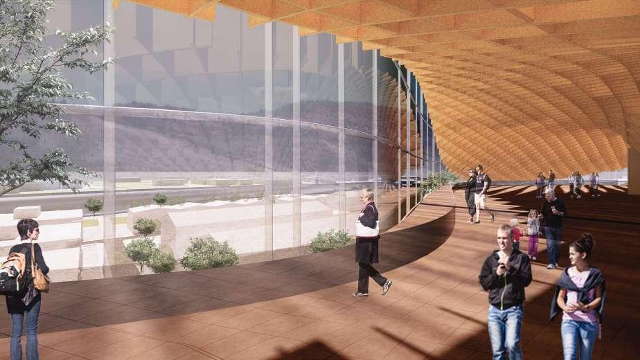
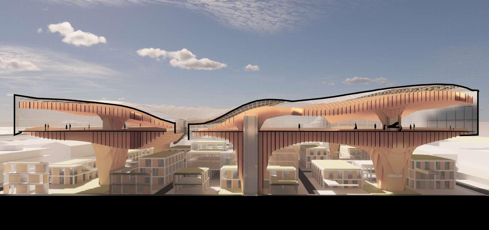
T he initial idea of canopy design comes from a large number of oak trees in the area. In addition, the symbiotic relationship between trees, animals and fungi also gave us inspiration for the design of the incubator. In nature, plants provide nourishment and living space for fungi, and shelter and food for birds in trees. In the design, the canopy will collect rainwater and solar energy, which will provide water and energy for the buildings and green plants below.
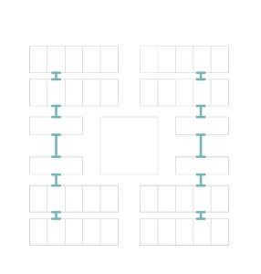
1. The urban design of the central area start with the Savannah Ward.

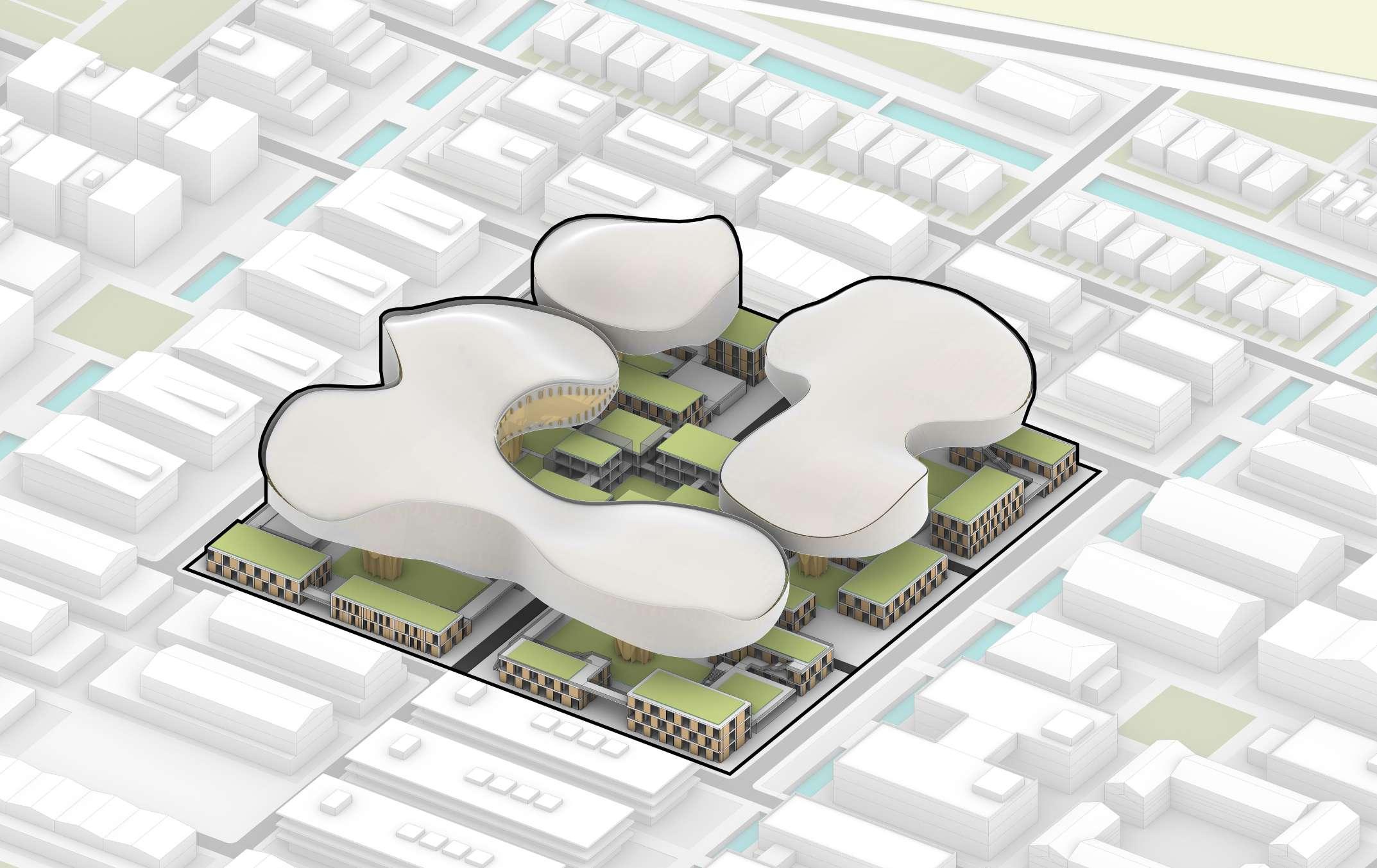
2. Continue with the Factral idea, the central area separated with six different parcels surrounding the initial square.
3. According to the Savannah Ward, the buildings will be designed on the sites.

4. Based on the functions, the greenery space will be expand and provide more opening space for the entrepreneurs.
5. In order to provide more convenience and dynamic working experience, buildings will be connected by the path/ bridges.
Savannah Oak Trees Fungus Fungus Symbiotic Relationship Trees Bird Nests Bird Nests

T he initial idea of canopy design comes from a large number of oak trees in the area. In addition, the symbiotic relationship between trees, animals and fungi also gave us inspiration for the design of the incubator. In nature, plants provide nourishment and living space for fungi, and shelter and food for birds in trees. In the design, the canopy will collect rainwater and solar energy, which will provide water and energy for the buildings and green plants below.


Residential (hotel/apartment), Public green space, River walk, Ferry berth


The buildings on the opposite bank are closely related to the tourism industry and were shot at our design site. The design needs to ensure the scenery of the coastal area.

A intergrated office space, combined with bionic design ideas. Built as a high-tech entrepreneurial working area with bursts of inspiration and collision of ideas.


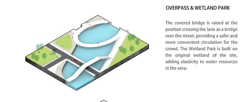
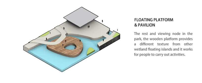
Introducing watercourses, adding different experience to urban spaces, reducing surface runoff, and increasing regional water resiliency. Combine the waterfront wetland and wetland park to build a circulating water channel around the site.

 ACCELERATORS, OFFICES)
WATER FRONT WETLAND PARK
Retain the original wetlands along the shoreline of the site, and echo the waterfront space built in the Savannah neighborhood, build a wetland park as a public space for waterfront leisure and entertainment
ACCELERATORS, OFFICES)
WATER FRONT WETLAND PARK
Retain the original wetlands along the shoreline of the site, and echo the waterfront space built in the Savannah neighborhood, build a wetland park as a public space for waterfront leisure and entertainment
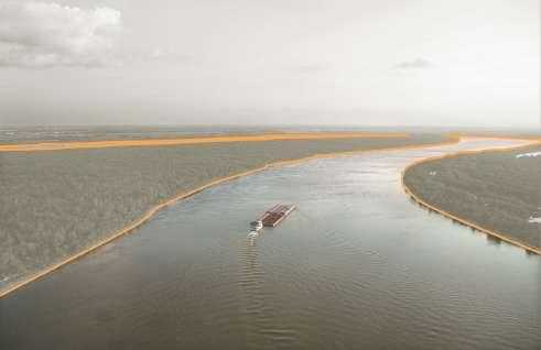
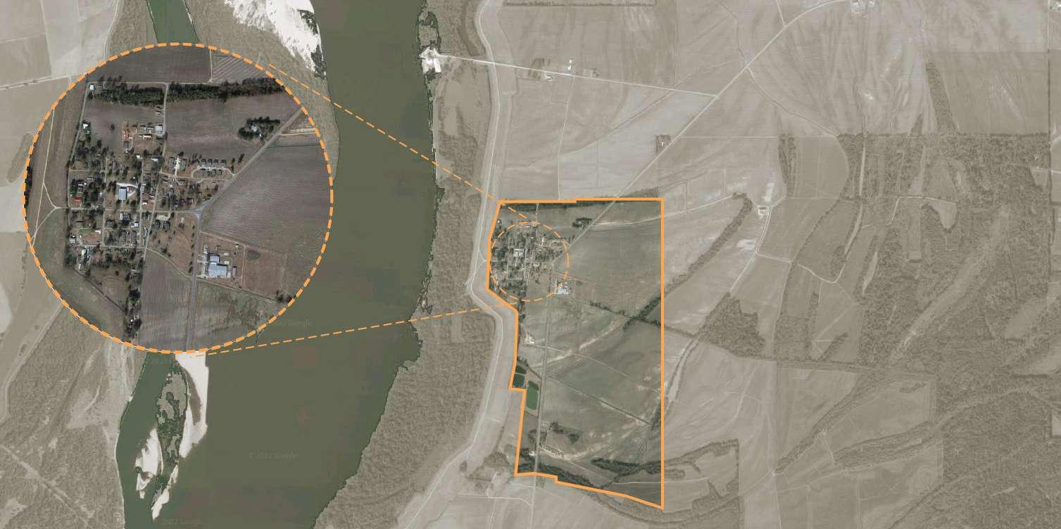
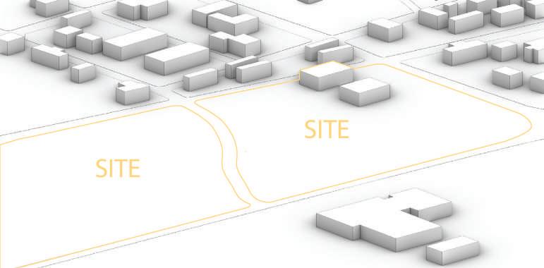
Mayersville, mississipi Personal Academic Work, April, 2022


This project is dedicated to providing a series of affordable housing for those who live in a small town called Mayersville on the coast of the Mississippi Delta. The town was plagued by flooding, and local residents had to live in their flooded homes for long periods of time. Once the flood hits, the flood may last for several days here. It is very important for the local residents to have a normal life during the flood period.
This project is a pilot project of flood housing, and I will choose a site in the east of Mayersville for development. In order to solve their problems, I connected all the residential areas with bridges. When the flood comes, people can also go to the community center area to buy food and exercise. Besides, based on a modular design, I added and assembled a series of 16’x16’ wooden “boxes” in a raised wooden frame (48’x48’x48’) to provide local residents with Quick-to-assemble and unique modular homes. Once the project is successful, the local area can extend this building module to the interior of the city to replace the existing local houses.
1. Mayersville is a town on the east bank of the Mississippi River, and the county seat for Issaquena County, Mississippi, United States.
2. It is located in the Mississippi Delta region, known for cotton cultivation in the antebellum era. Today, the residents of the city are still mainly agricultural
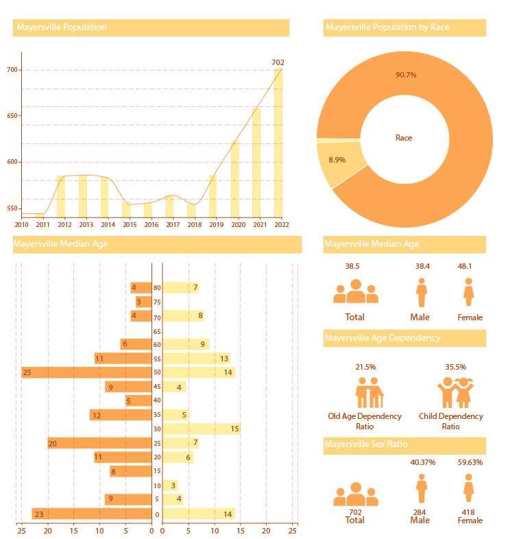
3. As of the 2020 United States Census, there were 433 people, 155 households, and 66 families residing in the town. In this majority-black town African American, 90.2% were African American, 9.7% White and 0.2% from some other race. 0.2% were Hispanic or Latino of any race.Besides, most of the citizens are over 50 years old.
4. Because the city is located along the Mississippi River, local residents are often suffered from the flood. Although in most cases the height of the flood is 2-3 feet, with the effects of the greenhouse effect and climate change, the height of the flood is likely to rise in the future and greatly affect people’s lives.

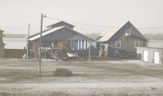
5. The towns are mainly flat, and most houses are one- or two-story dwellings and mobile houses. Most of these houses are not flood protected.

6. The local houses are not treated with flood protection. When the flood comes, most of these houses will be submerged by the flood. In severe cases, the flood may last for several months or even half a year, causing serious damage to local houses and seriously affecting the lives of residents.
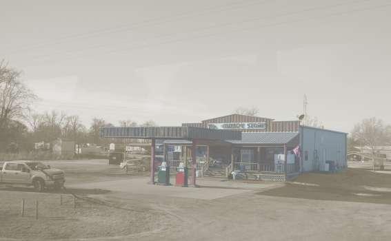
8. If local residents want to go out to buy supplies during the flood, they have to choose to travel by boat. For a town with an underlying aging population, long-term boating out to buy supplies can be a problem.

Normal Time: In most of the time,

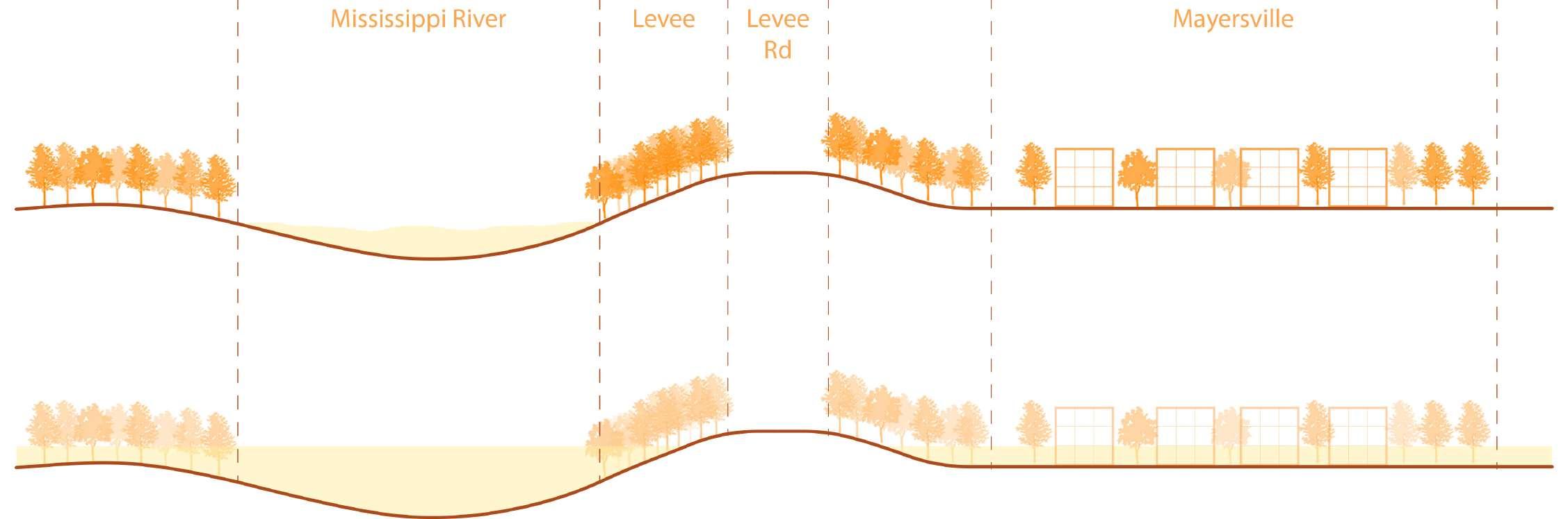
Flood Time: During floods, the Mississippi River will be raising tide which will flood the houses in Mayersville, and people have to choose to travel by boat. In order to provide more convenient and safe living conditions, I will have to renovate the houses in this small town
 Mayersville, Mississippi


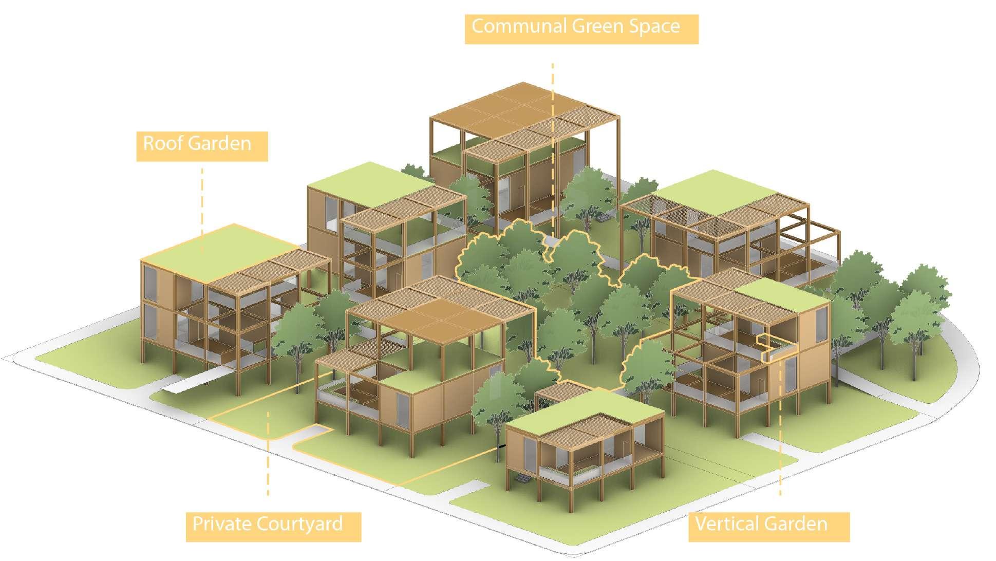
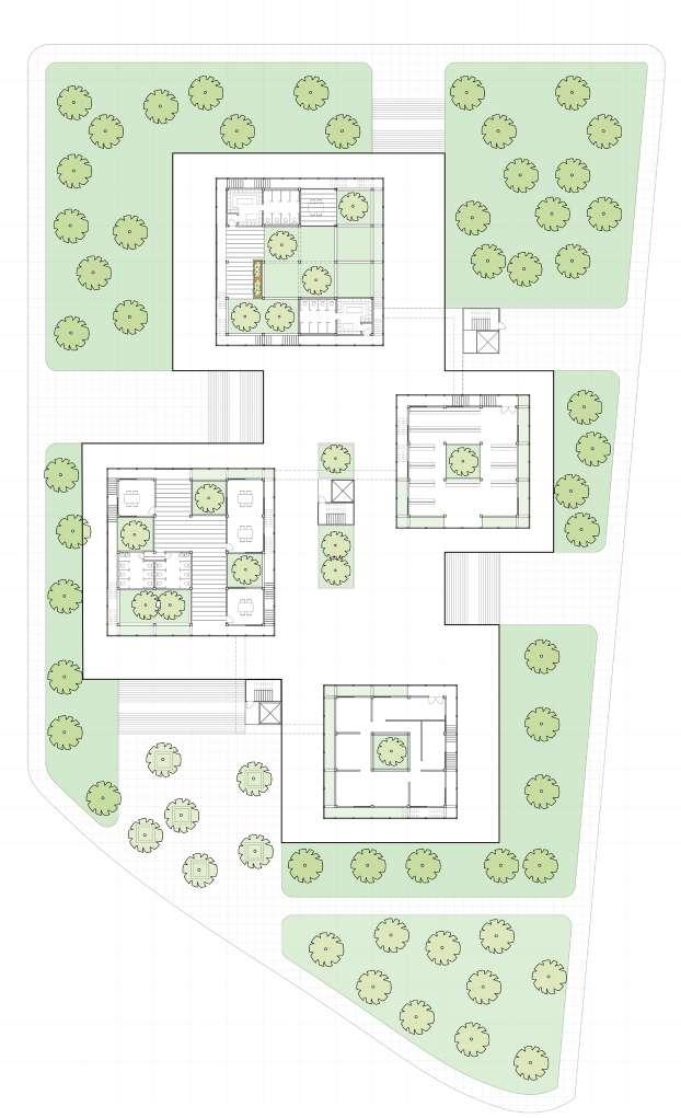
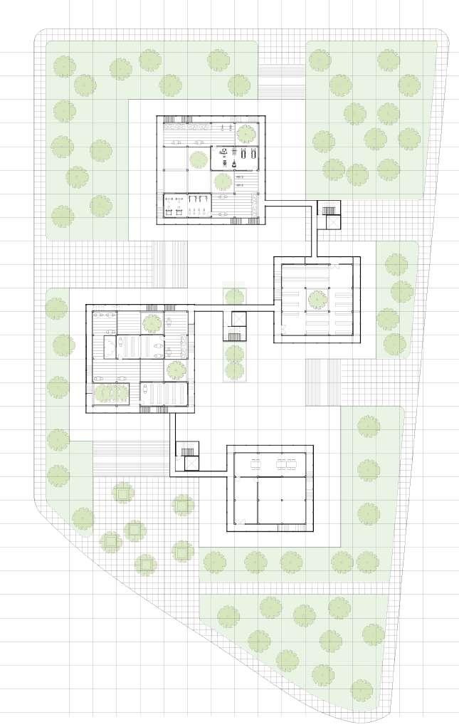
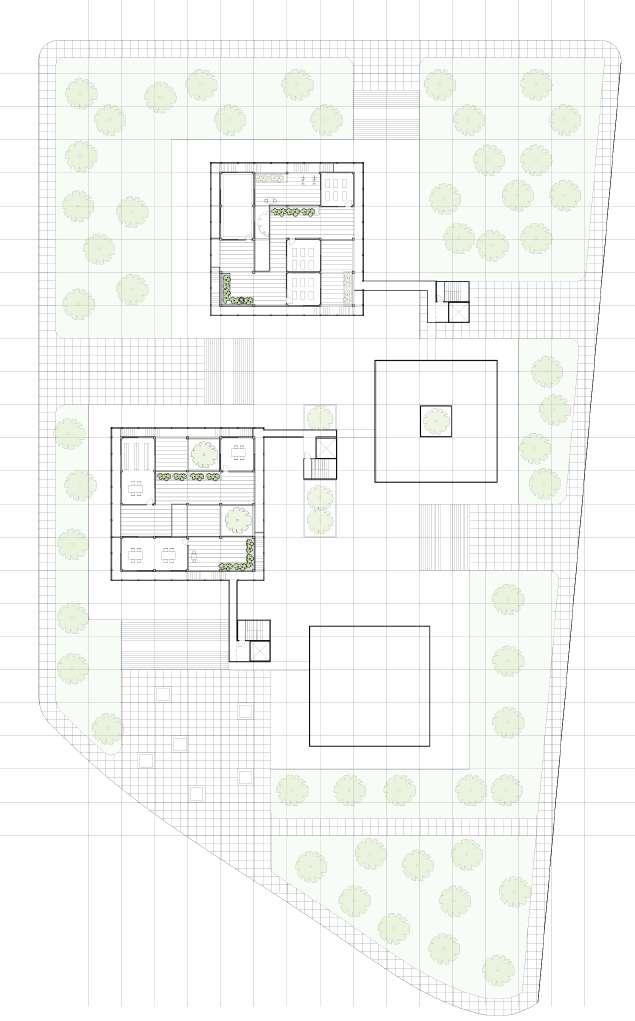
In the town scale, the urban design is based on the grid system, besides, with the surrounding of the family houses, the center of residential block will become a co-living space (communal sunken park and community center) for serving the residents.


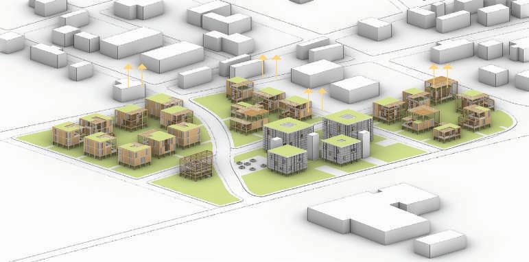


Each of the block will connected by the elevated pedestrian path to the community area. During the flooding period, people can still have their daily life on the elevated pedestrian path, go to the community house to work and study, exercise, and buy foods.
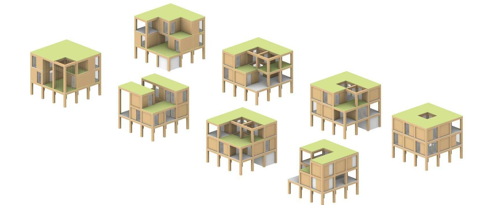
The Strategy of family and community house is modular design. The building frame is a 16x16 feet heavy timber structure, with adding 250 sq ft modular cubes, the building structure will become different size and variation based on the family composition.
1. Located in the central Mayersville, this project includes single family houses, duplex houses and community center.

1. The family house design based on the modular house.
2. Rasing the building structure to prevent the flooding.
3. Using the pedestrian path to connect all neighborhoods in one residential block.
4. All the residential blocks conncet to the community center, which will provide a normal life during the flood period.
4. The idea of house and communtiy center is based on the modular design, the house owner can add the “box” into the heavy timber frame to expand their house in the future.
2. In order to arrage the programs of this project, the site is separated into six parts, which are duplex house, single family house, community center, park and future use.

The project’s strategy is based on the passive design Despite its location along the hot Mississippi River, the project is dedicated to using wind energy and green roofs to reduce indoor temperatures to provide comfortable spaces for local residents.

5. In order to get rid of the problem of flooding, the houses and community center will lift 10’ above the ground by wood frame structure.
3. The organization of each block is based on the 16’ x16’ grid system.Each family/a house will have a minimum area of 9216 square feet (96’ x96’).
6. Each block will connected by the elevated path,residents can easily go to the community area during the flooding period.
 Residential Area Community Area Residential Area


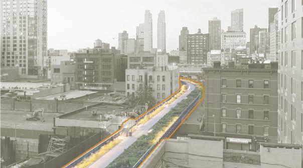
Urban Intervention in Jackson Square, Boston, MA Personal Academic Work, Spetember, 2019-Decmeber, 2019
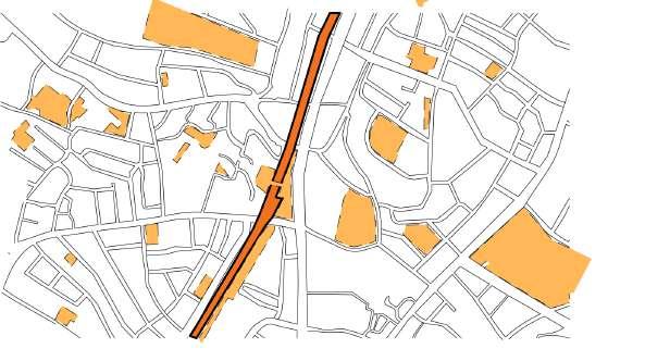
This project is located in Jackson Square, Botson, MA. Jackson Square is one of the stations on the Orange Line of the Boston Metro, and the orange line is located on the Southwest Corridor (a linear landscape attraction is Boston). The Jackson Three miles away from the downtown Boston, Jackson Square is located in a residential area of Boston, most of the residents are black and Hispanic in this area.
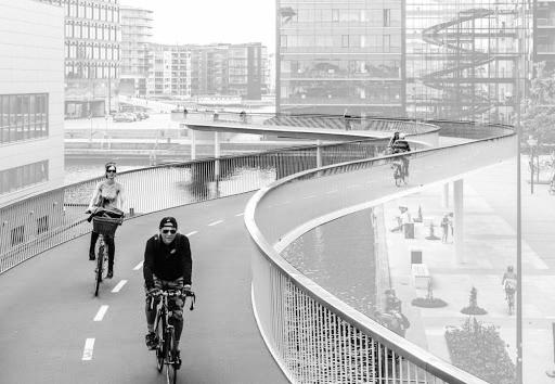
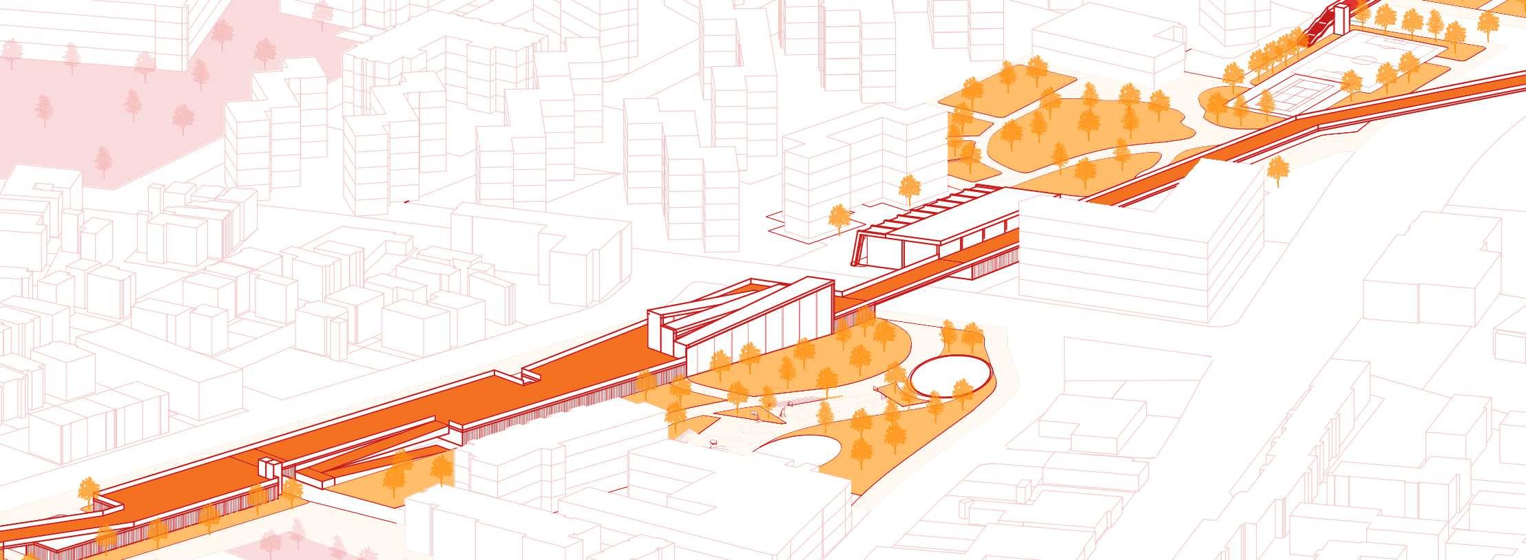
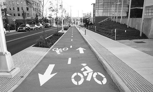
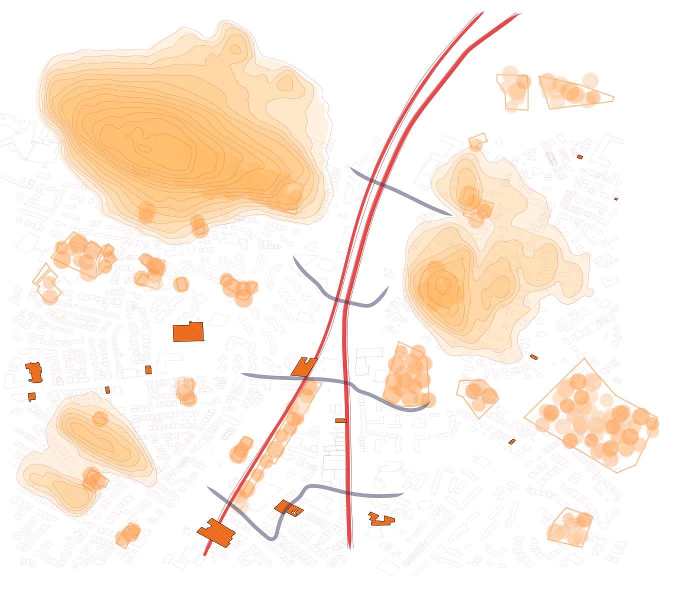
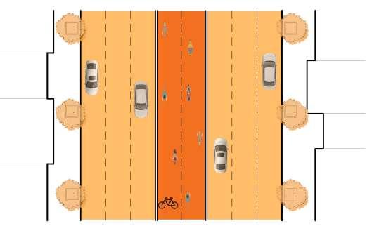
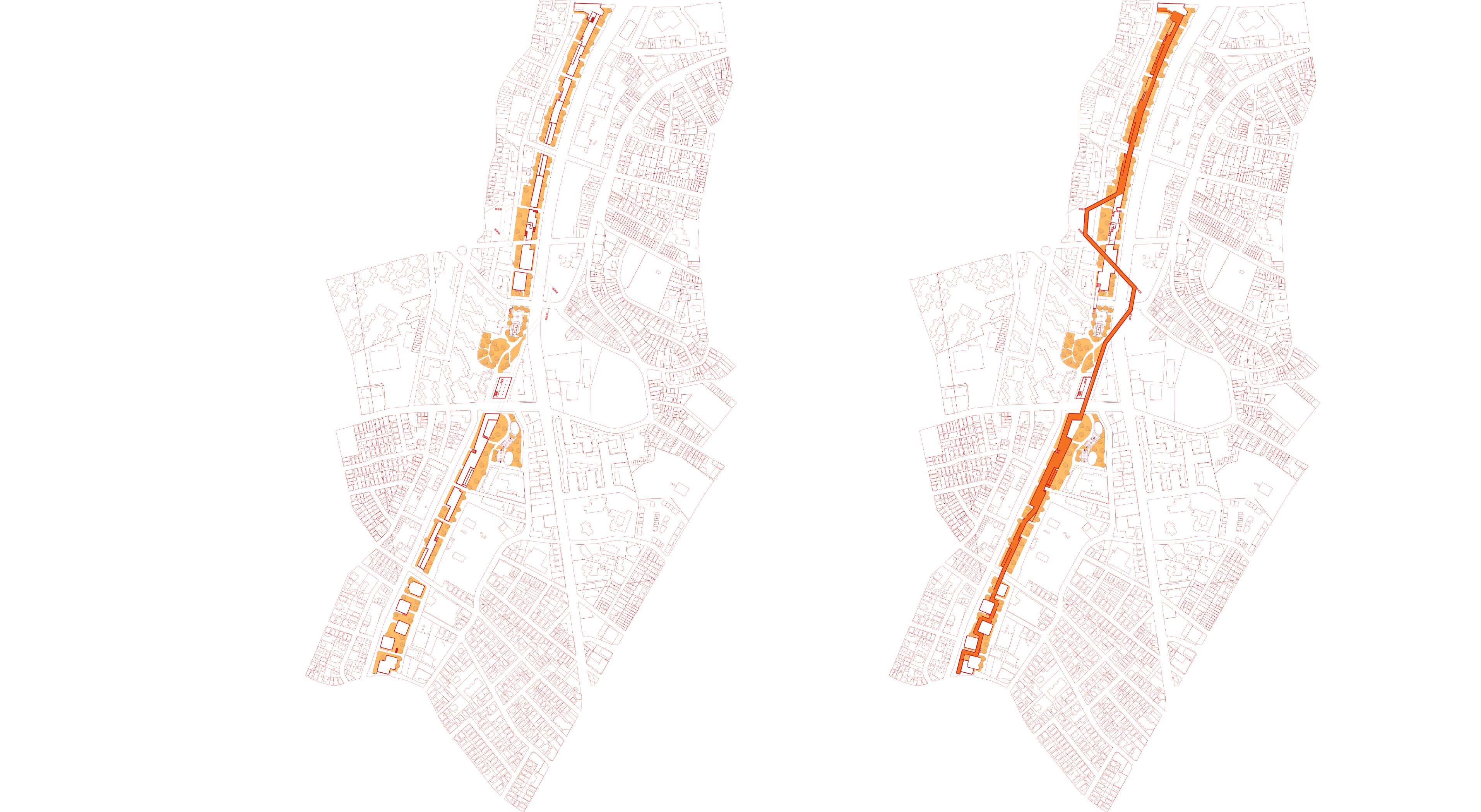
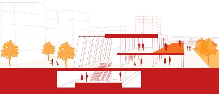
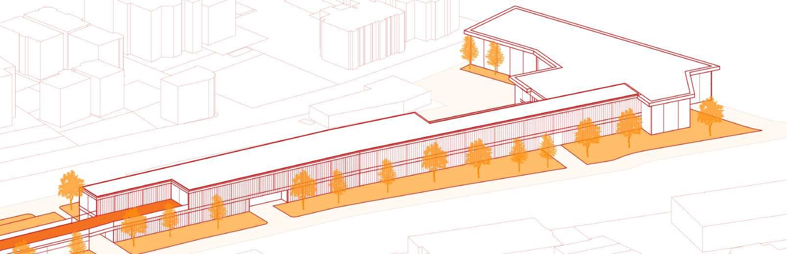
Based on the investigation and observation of the current situation, a metro station with the subway tracks exposed to the air, divided the city into two separate communities. Moreover, cycling was a popular outdoor sport among Boston people, but the cycle paths near Jackson Square were too simple and inconvenient. With all those factors into consideration, I designed to build an urban complex above to cover the metro rail with a cycle super-highways on the roof of the urban complex to reduce the negative impact of this barrier on the city and promote more communication between the two communities, and strengthen the importance of South Corridor as a landmark landscape.
1. In recent years, global warming has become increasingly serious, and low-carbon travel has become a trend.

3. Bicycle highway has become an indispensable public facility all over the world.
2. In April 2018, the United Nations General Assembly declared June 3 as International World Bicycle Day.
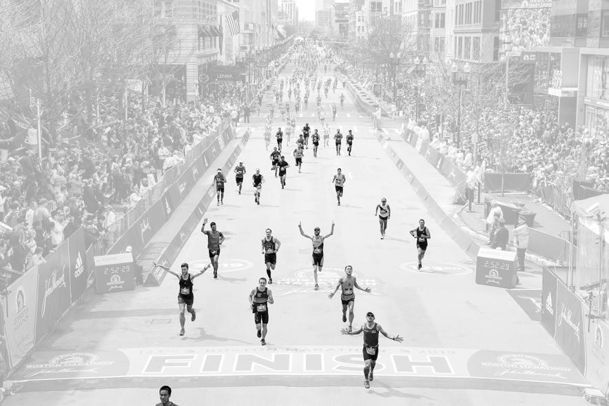
4. In Boston, outdoor sports are very popular, the annual Boston Marathon is the goal of many sports enthusiasts
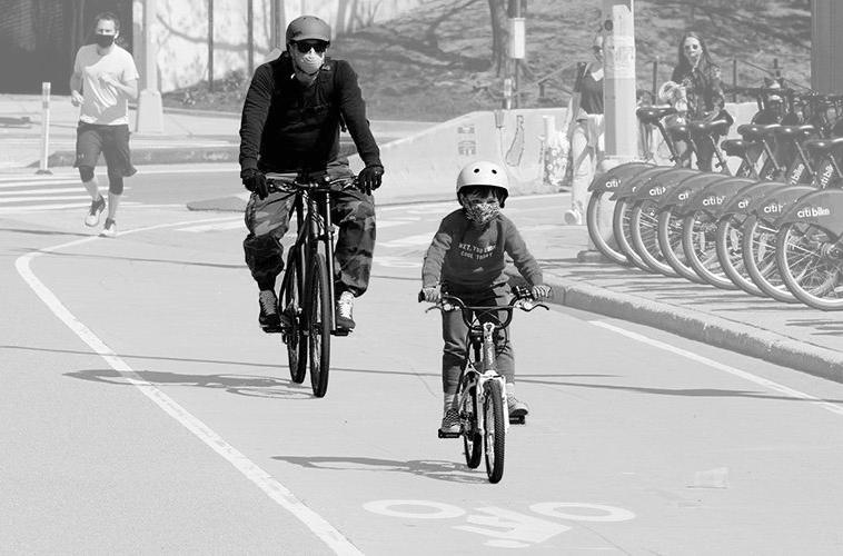
5. Nowadays, during the epidemic of coronavirus, many people still choose outdoor sports.
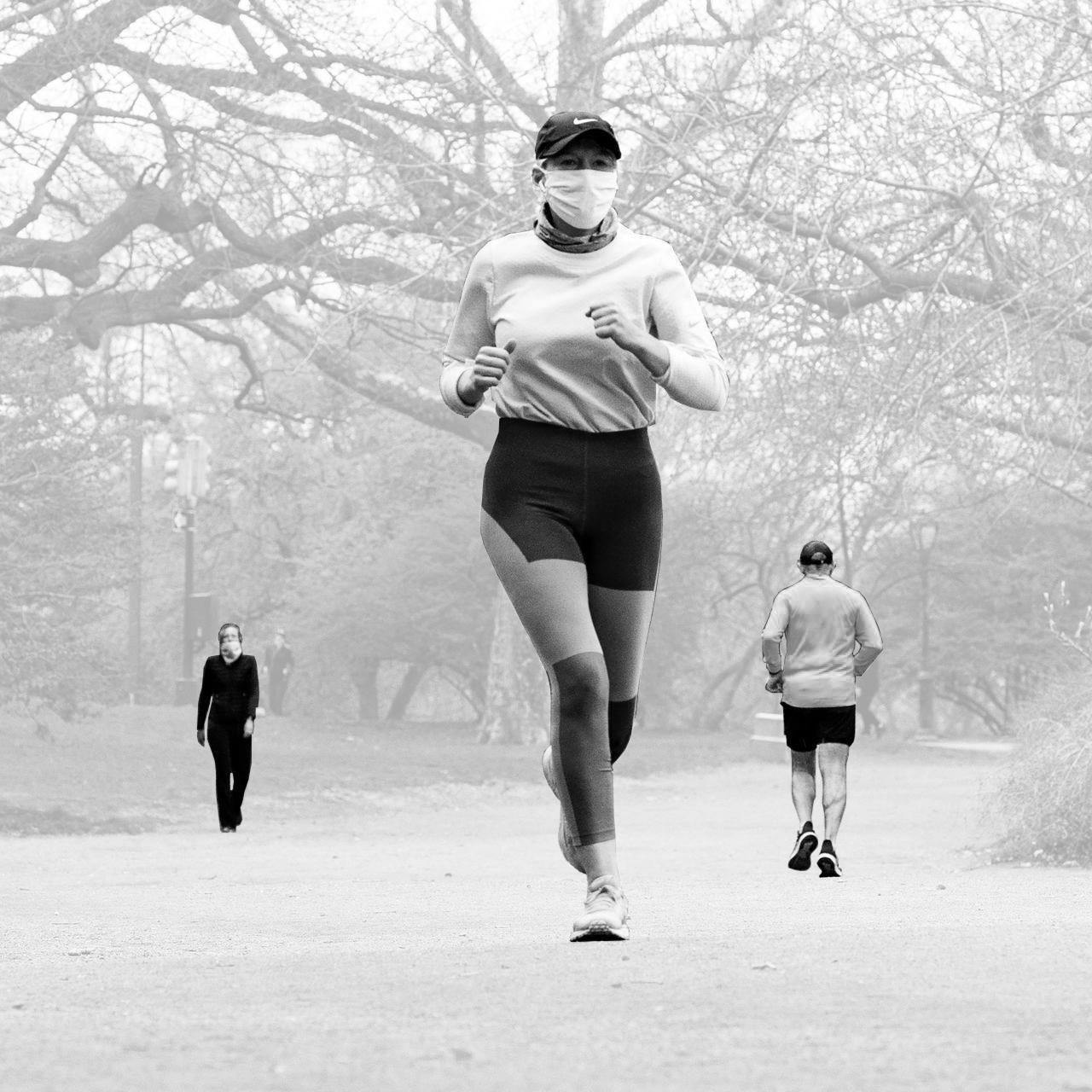
6. Compared with the jogging, cycling may be a better choice for exercise and travel in current situation.
7. For this project, the site is located in the Jackson Square, which belongs to the South West Corridor. In the SW Corridor, the bike path becomes a really important element.
8. The underground train track occupies too much land in the South West Corridor. If this land can be fully utilized, the bicycle highway will provide a place for local residents taking exercise during the epidemic of coronavirus.

Step One: Create a striped shape of building complex to overlay the current open-air train track. People will asscess

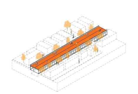


Step Two: The roof of the building structure will become the bicycle highway, which starts from Roxbury Crossing Station to Jackson Square Station and the Stony Brook is the final destination of the bicycle highway.
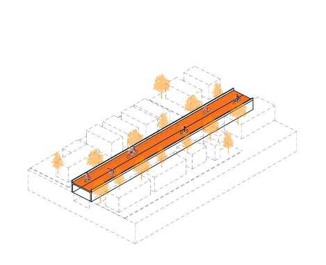
Step Three: With a serious of buildings will be built above the current train track, more horizontal connection will be provide to the local residents.

Step Four: With different function of landmark buildings built in Southwest Corridor, more and more visitors will be engaged to the Southwest Corridor, which will enhance communication between communities and reshape local popularity.


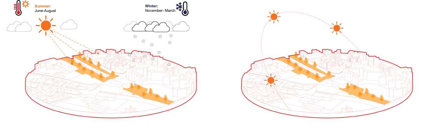
Due to the existence of the hills (Mission Hill and Fort Hill), the terrain of Jackson Square are slopes which become an obstacle in local residents’ life.
Around the Jackson Square, Greenery spaces are the most important elements, it can be the boundary and it also improve a comfortable space for local residents.
The main street and train track become the boundary of the Jamaica Plain, it sprits the Jamaica Plain and Roxbury.
Landmark
Although Jackson Square is far from the central Boston, it still several local landmark building structures, like train station, Churchs, and supermarkets like Wholefood and Stop Shop.
Connection
Going cross the train track and Columbus Ave, paths connect Jamaica Plain and Roxbury.
One: Reducing the aggravating impact of subway tracks on urban segmentation


Two: Reshaping the landscape design of the Southwest Corridor and Increasing local visibility
Three: Gathering all the local landmark buildings around two sides of the train track to the Southwest Corridor
Four: Providing a professional bicycle highway to the local residents and cyclists

Five: Through this project design to enhance the communication between local communities


 Train Station Jackson Square
Train Station Stony Brook
Train Station Jackson Square
Train Station Stony Brook

The horizontal circulation shows the connection between two communities after the project built above the orang line. Residents who live on the two sides of the train track can easily go to the other side any times and any where.
The Vertical circulation shows how to access the bicycle highway on different spots of this project. The Bicycle Highway start from Roxbury Crossing Station to Stony Brook Station, cyclists can easily arrive at the Bicycle Highway level and start their journey by stairs, ramp and elevators.
 Apartment
Grocery Store
Community Center
Art Gallery Gathering Space
Train Station Jackson Square
Train Station Roxbury Crossing
Train Station Stony Brook
Restaurant
Gym
Supermarket
Apartment
Grocery Store
Community Center
Art Gallery Gathering Space
Train Station Jackson Square
Train Station Roxbury Crossing
Train Station Stony Brook
Restaurant
Gym
Supermarket
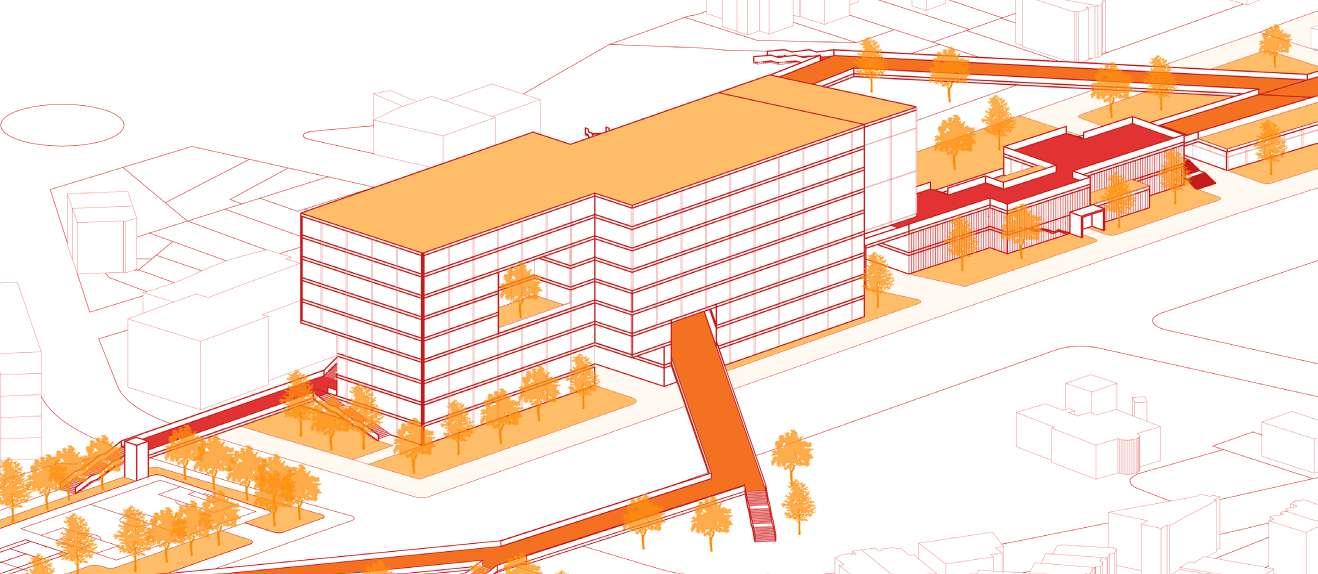
The Roxbury Crossing is one of the train station of Orange line in Boston, and it is also the strating point of the bicycle highway. After the renovation of the Roxbury Crossing Station, it will become a two-floor building structure. On the ground floor it is the station hall and supermarket, the second floor is the bicycle highway which start in the station hall and it is the interior path at the very beginning of this project.
Section
Axonometric Diagram
The circulation diagram shows that bicycle highway in the office part will split into two part. The orange path is the bicycle highway and the red path is the pedestrian path from the roof of resturant, crossing the office and it finally go to the street park.


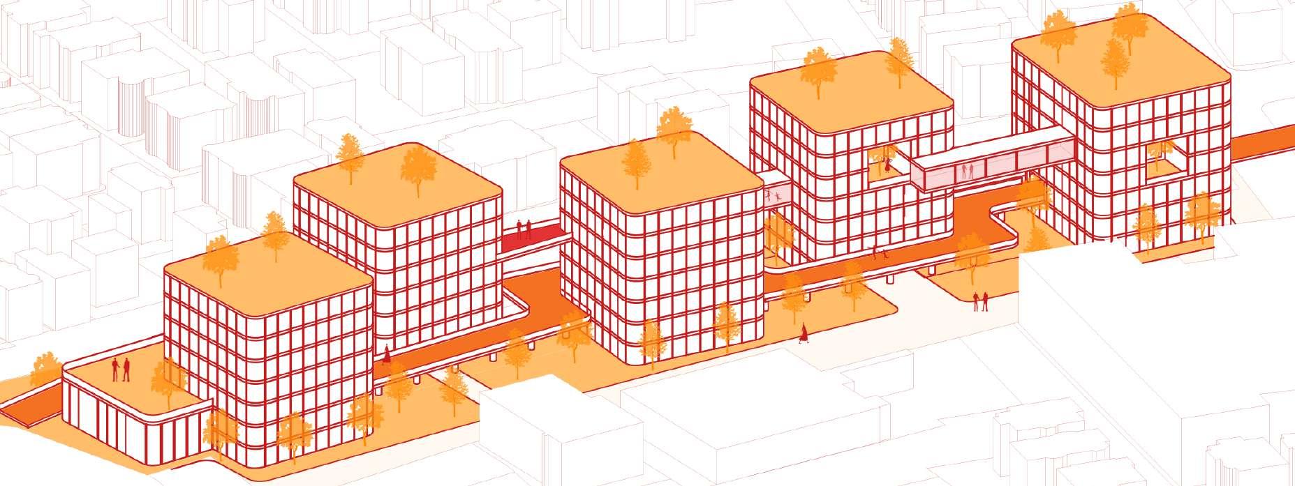


The Second spot of this project is the office. The exterior bicycle highway will penetrate the office building and it will go cross the Columbus Ave to the other side. Thus, residents from two commuinties can easily go to the other side.
Bridge View
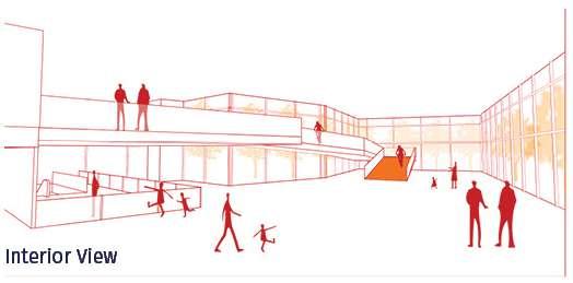
The interior view from the apartment shows the relationship between residents who are inside the building and the cyclists.

Interior View
Section
This project will end up at the Stony Brook Station and apartment buildings. The bicycle bridge will connect all the buildings together at the same level. The residents are easily arrive at the bicycle path and go to other spots on this Southwest Corridor.
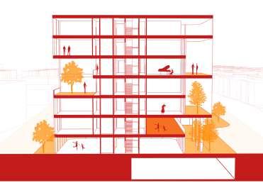
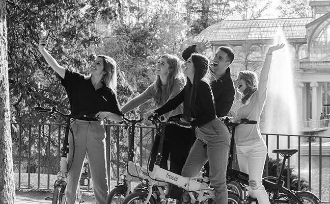
This project is a Receation and Training center in Madrid during my study abroad in IE University. The site is located in Calle de Mejía Lequerica, downtown, Madrid. On the site, there is a site building, we can use it and redesign it as one part of my design.
Based on the local culture and residents hobbies in Madrid, Real Madrid is the symbol of Madrid sports, football and basketball will become the mainstream sports. Thus, The Receation and Training center mainly focus on football(soccer), basketball, running, boxinng, swimming and so on.

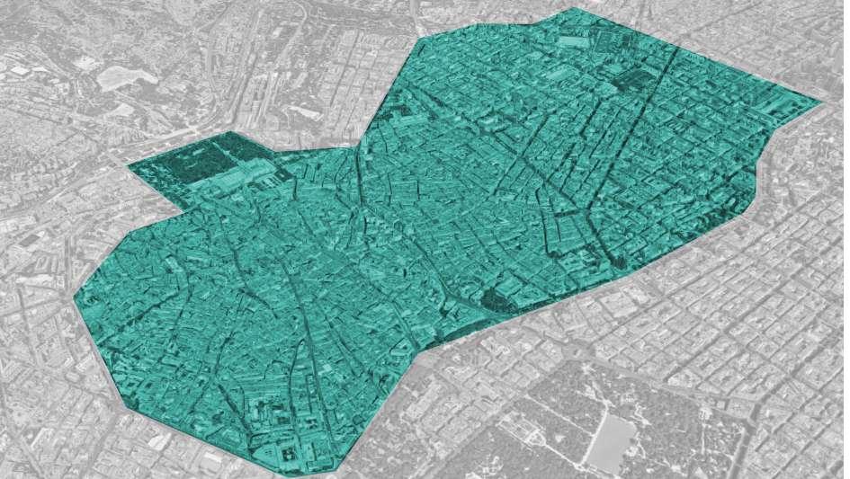
Besides, because of the high density of building structure in old downtown Madrid, The city center (Centro and Chamberi) lacks city parks and green spaces, residents have nowhere to go, and they do not have too much gathering space for daily use, even the quality of citizens’ health may also be affected by the lack of green plants. Therefore, the concept of “urban valley” is proposed to provide a healthy sports venue for citizens’ daily life.
1. . One of the most popular spectator sports in Madrid is football. Real Madrid and Atlético are the two main professional football clubs in the city. Local residents are fall in love with these two teams and football.
2. In addition to a fan of Real Madrid and Atlético, locals also particularly like sports. People also do the exterior exercise around the downtown area (Centro and Chamberi).

5. In the downtown area, the street are narrow, so local sports lovers cannot do outdoor exercise.


3. Accroding to the data, more than 64.5% of people are 18-64 ages, which means the target group of this project focus on young and middle-aged citizens.
4. Most of the local gyms around the site only has simple machine exercises, and people cannot do large-scale team sports like football in these gyms.
6. Around the site, reidental buildings cover more than 90% of the area. Both Chamberi and Centro areas are particularly lack of greenery space and gathering space for exterior exercise.
7. In order to give local sports enthusiasts a better exercise experience. This project focuses on providing a green space for local residents while providing multifunctional recreation and training center.
Chamberi
This diagram shows the site location and the serving area in downtown Madrid(Chamberi and Centro). Inside this two districts, there are several fitness places, however, most of them are interior gyms, local residents only can do interior exercise rather than large scale sports like football(soccer), basketball, swimmAing and so on in old downtown area.
In oder to provide a space for Real Madrid’s fans to play football and basketball, and other citizens to do the daily exercises, this project will be a recreation and training center for different sports.
Age: 0~17 years 517,651
Sports Football(Soccer), Basketball, Tennis, Swimming Fitness, Running
In Madrid, because the successful of Real Madrid football (soccer) and basketball are quite popular among eenagers However in Downtown Madrid, there is not enough open space for teenagers o play football and basketball
Age: 18~64 years 2,048,653 Age: 65+ years 657,030

Sports: Football(Soccer), Basketball, Swimming Fitness, Running Yoga, Dance
Sports Walking, Nordic Walking Swimming , Yoga, Dance
In Centro and Chamberi, based on the excessive density of the city, the streets are narrow, therefore, citizens do not have too much open space for exterior exercises.

Moreover, most of the sports venues in Centro and Chamberi are indoor gyms, people cannot do the large scale sports, like soccer and basketball in downtwon area.
In the downtown Madrid, the high building density leads to a lack of greenery and exterior activities venue.

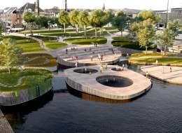
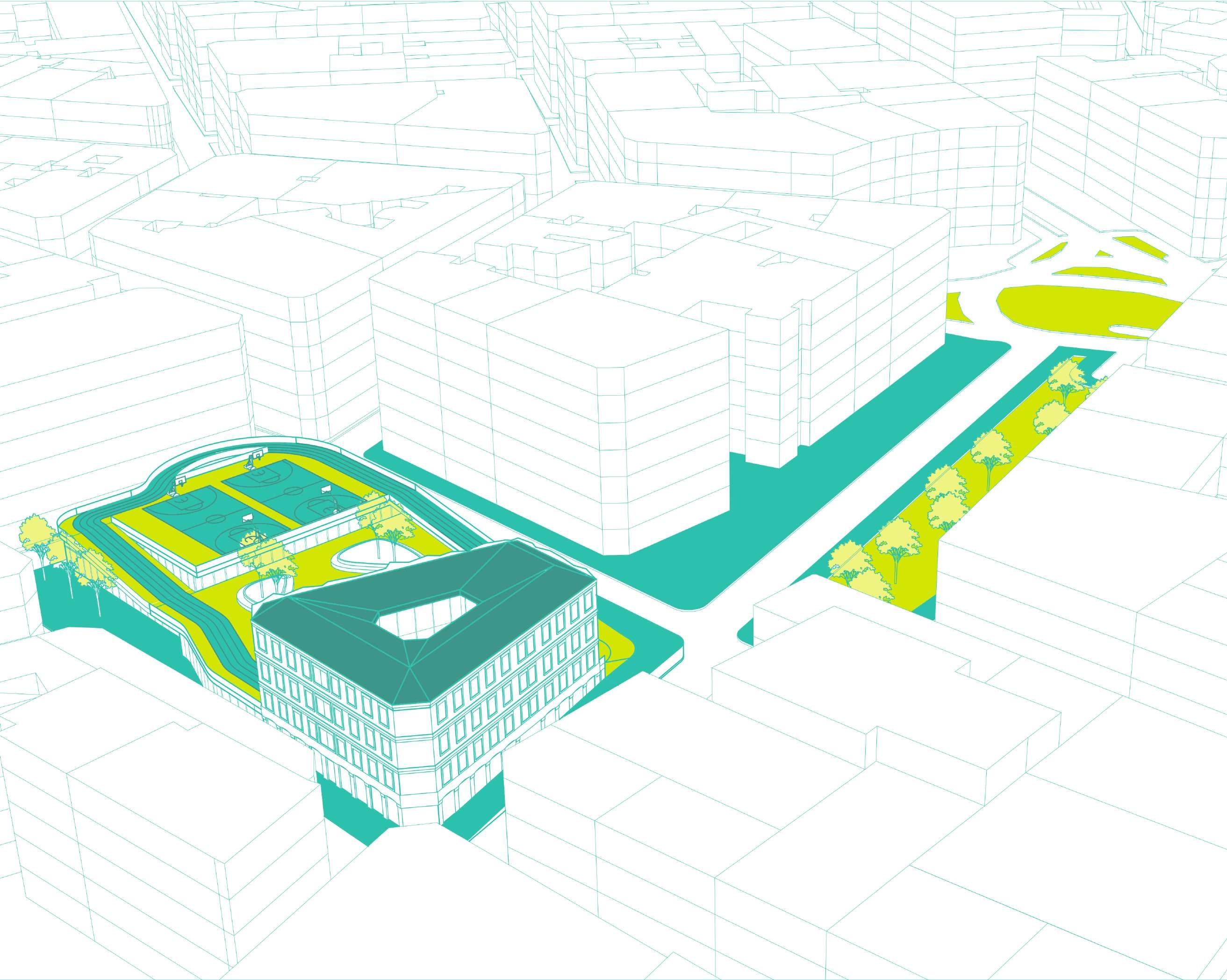
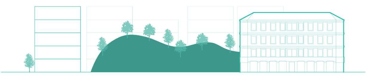
In order to improve the quality of citizens’ life, a “Valley” as the greenery space and outdoor gathering space is created in the downtown area.
Besides, Downtown Madrid also lack of urban parks, citizens do not have too much gathering space for daily use, thus, the quality of citizens’ health may also be affected by the lack of green plants.

A new building structure will be built ndernearth the the “Valley”, and the new building and the site building will combine together as a whole.
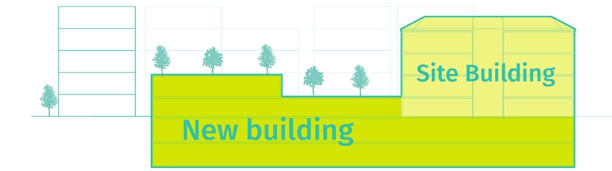


The concept of this project is City valley, and the complex of site building and the new building could be seem as a mountain, therefore, when citizens running on the roof, they will seem to be in the valley; besides, when residents climbing the climbing wall, they feel that they are climbing in nature.


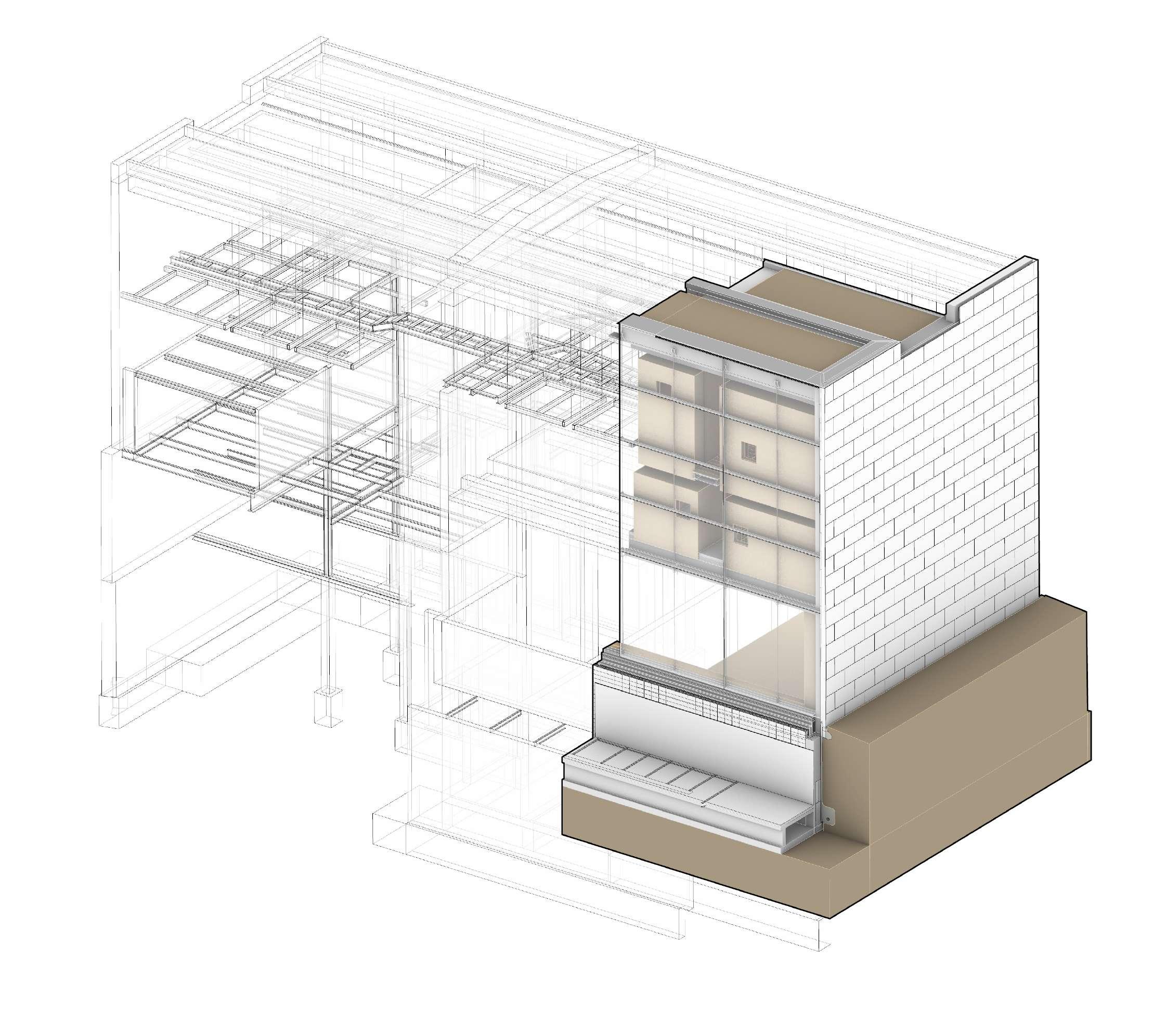
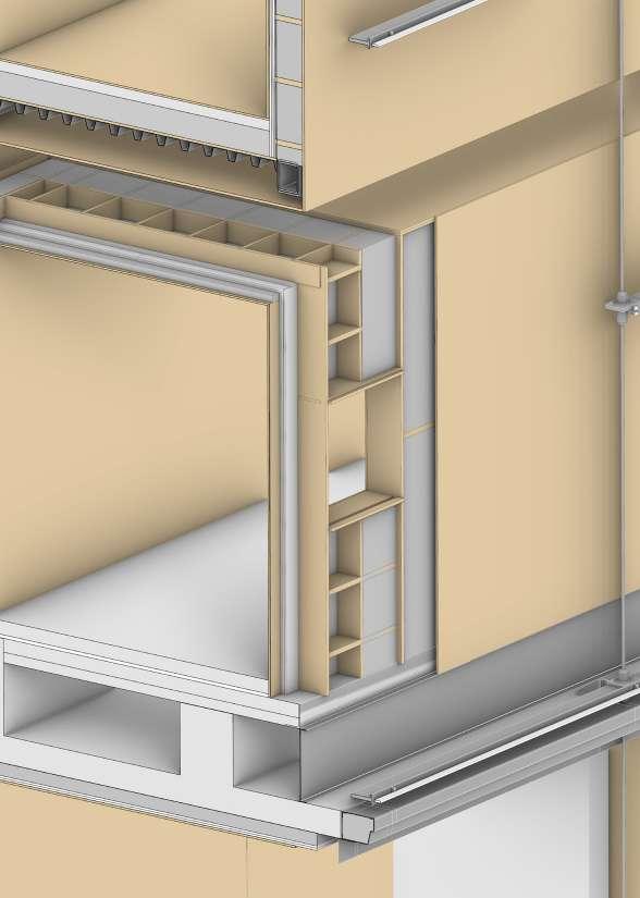
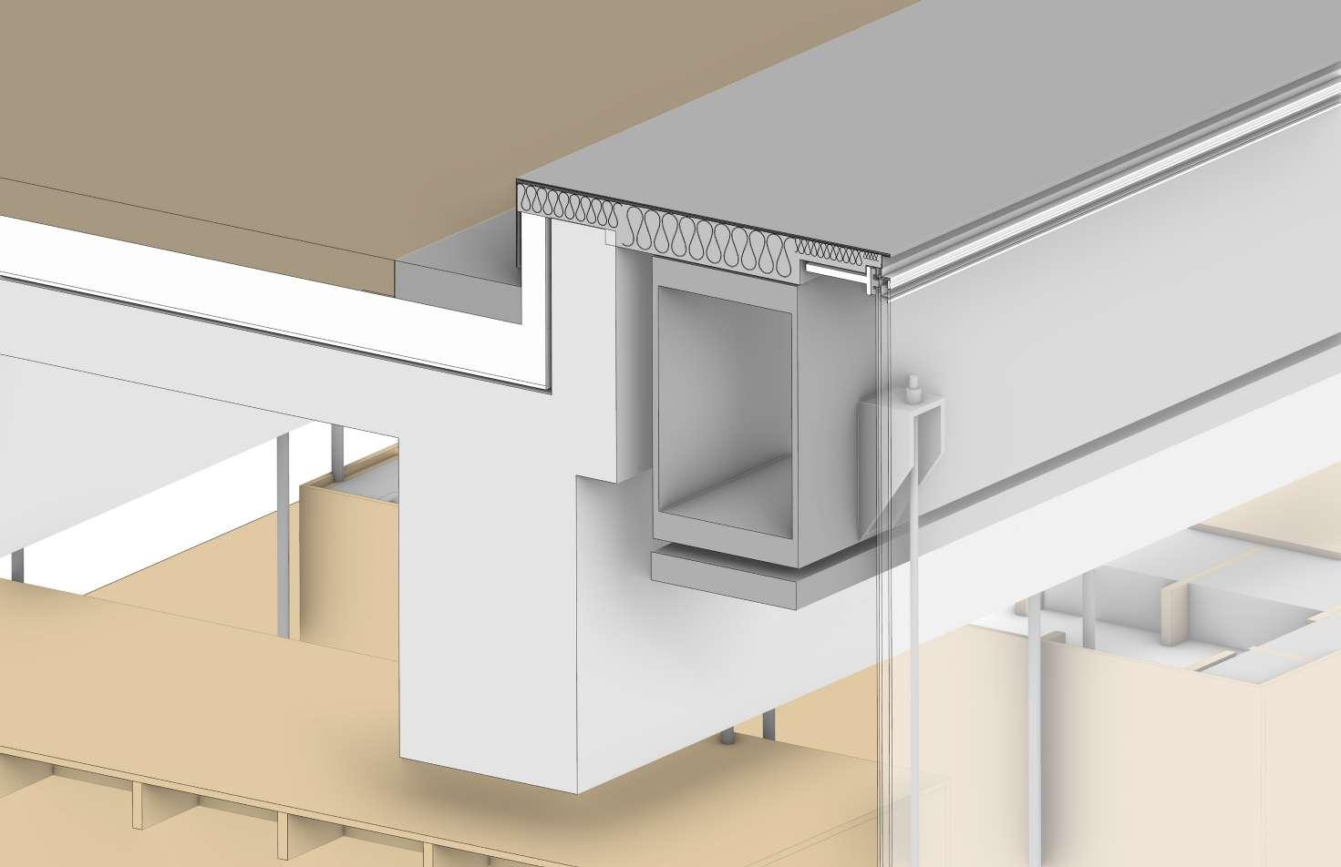
This case study is an integrated building system project. This project is dedicated to the study of steel-structured buildings. We analyze the structure of the building through architectural construction drawings and architectural photos, and use Revit or Rhino to reconstruct the model.
The model analyzed and reconstructed by our group is Steven Holl’s LEWIS ARTS COMPLEX, PRINCETON UNIVERSITY. Four of our classmates shared this building design, through our joint study and discussion, each person restored a corner of the building. My section is the southwest corner of the building. Through the analysis and study of this building, I have a deep understanding of the composition of steel structure and wood structure, as well as the assembly of glass curtain wall.
 LEWIS ARTS COMPLEX,PRINCETON
Legend:
1. Post-Tensioned Concrete Roof Structure
2. W30x18 Steel Plate Girder
3. Steel Rod
4. Flame Retardant Plywood Framing

5. Steel Curtain Wall Framing
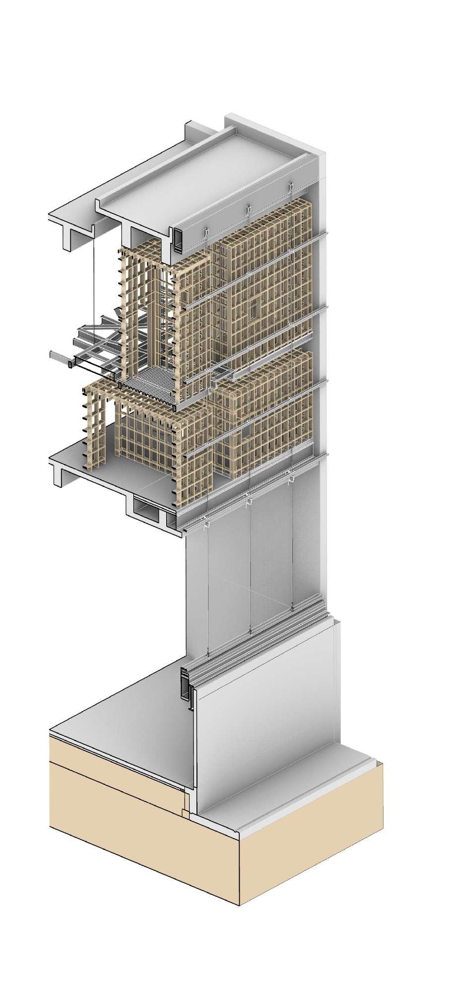
6. W 12x50 Wide Flange Beam
7. HSS 4x4x12 Suqare Hollow Beam 8 Steel Decking
9. Cast-in-Place Concrete Structure
10. 45mm Fully-Locked SS Spiral Strand Cable 11. W30x18 Steel Plate Girder
12. Concrete Masonry Unit
Substructure
Legend:
1 3 4 6 8 9 10 11 12 13
2 5 7


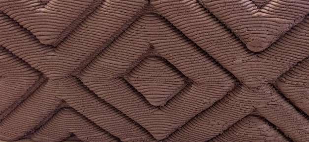
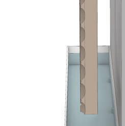
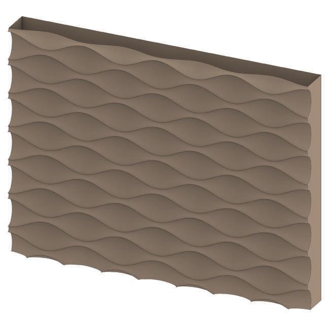
This is one of the project design from Robotic Ceramics course. The design of this course is based on the 3D printing ceramics. We program through grasshopper and then translate it into g-code to print the model. This project, we mainly focus on the architectural green wall/green facade.
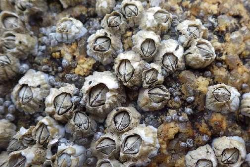
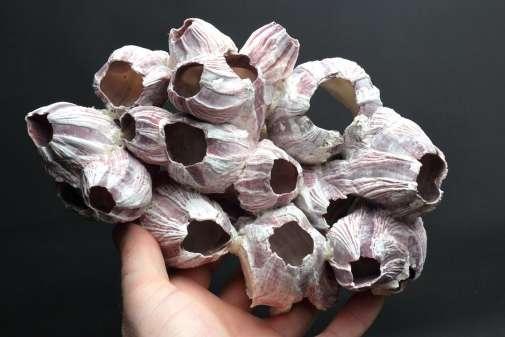
We were inspired by barnacles. As a marine animal, it often attaches to boats, rocks, and animals. Its shell is hexagonal with a hole in the middle. The idea was to attach plants to the facade wall similar to barnacles, with recesses in the wall as cultivation locations for the plants.
In order to use robotic ceramic technology to design green walls, we apply the principle of hydroponic plants to the vertical green walls. Based on the original permeability of ceramics, the sink located behind the wall will continuously deliver water and nutrient solution to the plants attached to the wall.


Hydroponics is a type of horticulture and a subset of hydroculture which involves growing plants, usually crops or medicinal plants, without soil, by using water-based mineral nutrient solutions in aqueous solvents. Terrestrial or aquatic plants may grow with their roots exposed to the nutritious liquid or in addition, the roots may be mechanically supported by an inert medium such as perlite, gravel, or other substrates.
The bodies of these organisms are totally enclosed by a stony gray-whitish shell. The size of these shells ranges from 5 millimeters to 10 centimeters. They take the form of a cone consisting of six plates fixed on the rocks. The active animal can only be observed within the water when the shell opens and the barnacles expose two branched appendages (cirri ) regularly hitting the water to catch food. They mainly feed on plankton.


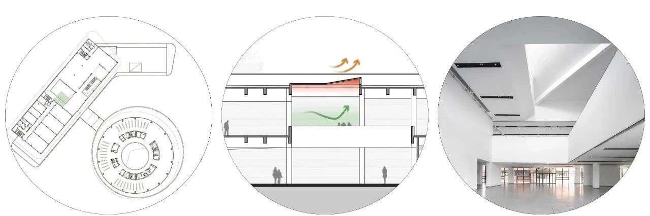
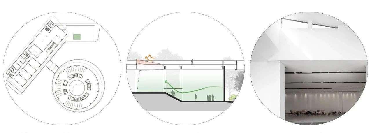
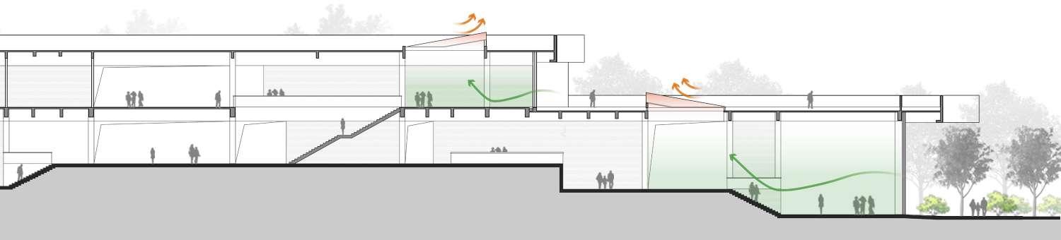
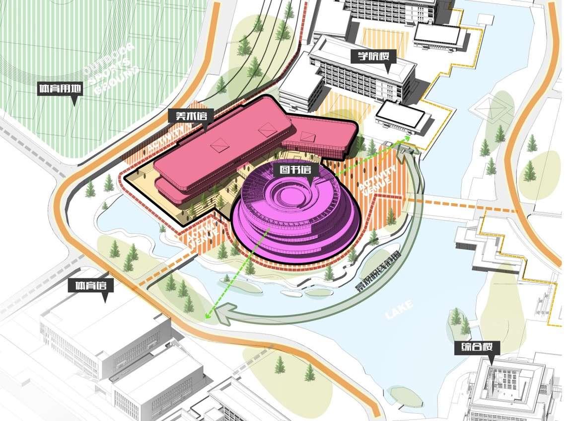
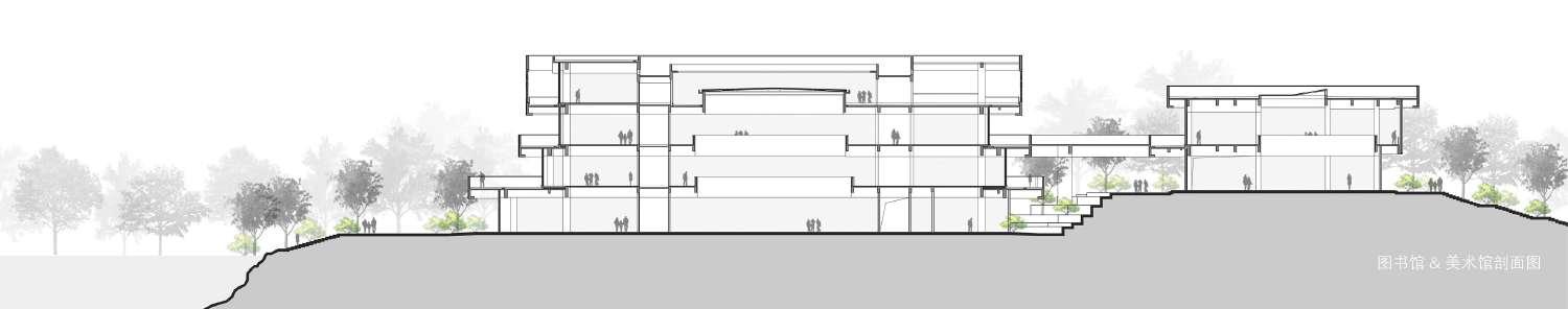
This project is a University design, this university was completed in early 2020 and is already in use in summer. I was working on the Library and Art Gallery Complex design. During the internship, I mainly focused on the diagram and technical drawings like plan, section and elevation drawing of the library and art gallery, and the digital model of this building structure.


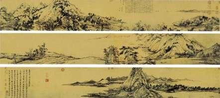
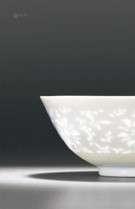
The shading components of the library are divided into two parts: overall (overall concept-landscape paintings) and detailed concept (detailed concept-Linglong Porcelain), which can be deepened into two basic architectural elements-repeated polylines as the interference basis of the module. The perforated plate serves as the skin foundation of a single module.


Yantai, Shangdong Province, China


Architectural Design& Research Institute of SCUT

Lead Architect: Jingtang He, Yang Wang, Yudan Pan
Yantai has a unique landscape pattern, with mountains, seas, cities and people coexisting. The site is adjacent to Fenghuang Mountain in the west, the Yellow Sea in the east, and Jindou Mountain in the south. Spatial shaping will take these three points as control elements to form a mountain and sea charm in the urban dimension.


The Chengfa City Plaza is a government project in Yantai, Shangdong,China. This project includes three individual part, city park design, the renovation of the government office building and Administrative service center. My task is to design the Administrative service center, the design intention is from the mountain, village and the sea and it reflects the integration and innovation of regionality, timeliness, and culture.
In this project, our team has three proposals,Yudan Pan and I was working on one proposal. I was working on diagram drawing, and digital model design of this project.
Project Competition Design: August, 2019 Image rendered by Yudan Pan
Fog Mountain Sea Rock


Step One: Place cube according to site.
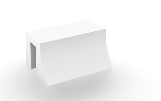

Step Two: Open up East-West relationship
The friendly platform facing the government building is formed by the retreating platforms. And implanted an ecological digression change system to strengthen spatial penetration.
The overall shape of the building conforms to the principle of planning the landscape pattern, and the shape of the mountain is constructed on the back of the city government to form a solemn and ritualized overall image.

Step Three: Create a friendly interface for the city government
Step Four: Strengthen the relationship of space penetration and form a building with backward terrace


The building pays attention to the continuation of the mountain-sea relationship from east to west. While opening the mountain-sea relationship of “Phoenix Mountain-Yellow Sea”, the building will form the spatial intention of the urban green valley by enclosing the two functional blocks.


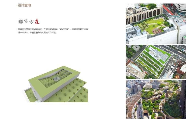
This plan also pays attention to the activation of the roof space and constructs an urban courtyard in the roof space. Getting clean land in a noisy city can also improve the working environment for office workers.

Step Five: Connecting NorthSouth architectural relations and introducing people
Step Six: Create a three-dimensional ecological building