
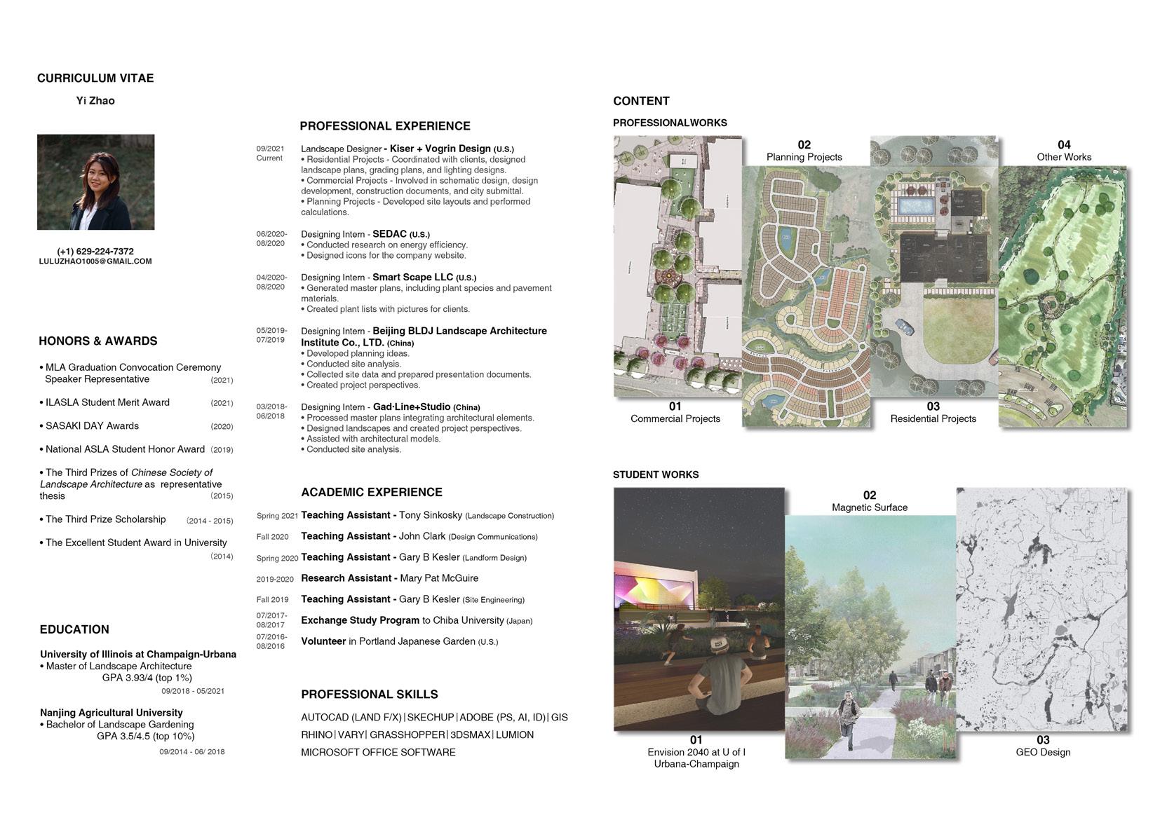
PROFESSIONAL WORKS -
COMMERCIAL PROJECTS
Welcome to the Commercial Projects section of my portfolio. Here, you will find a selection of my work in creating functional, sustainable, and visually appealing landscapes for commercial properties. My approach integrates the needs of businesses with environmental considerations, ensuring spaces that not only attract and retain customers but also contribute to the overall well-being of the community. Each project showcases my ability to blend aesthetic appeal with practical functionality, meeting the unique demands of commercial clients.
01
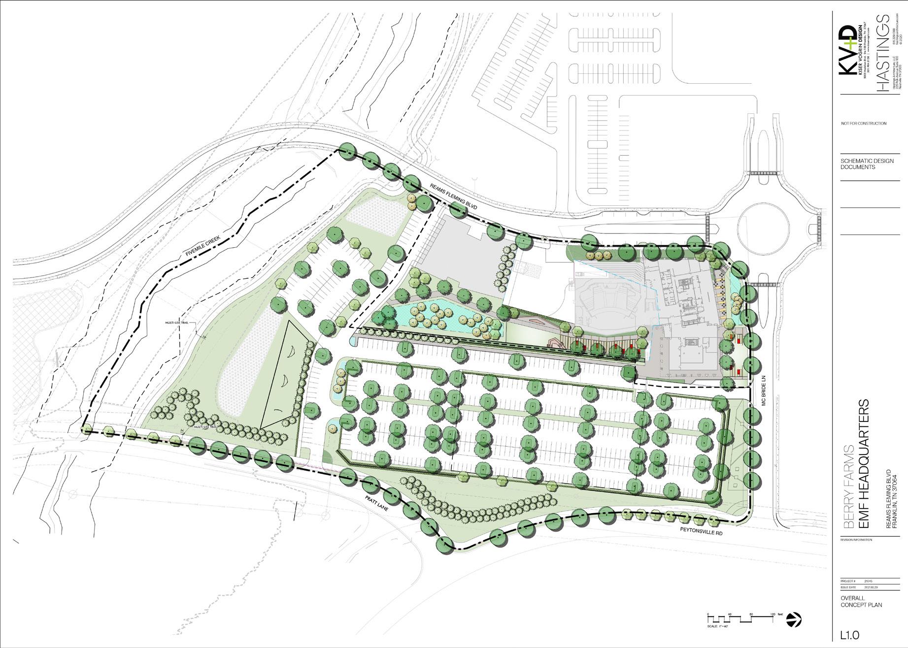
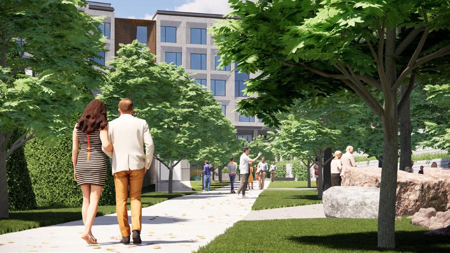
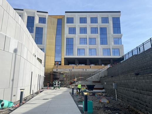
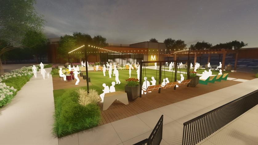
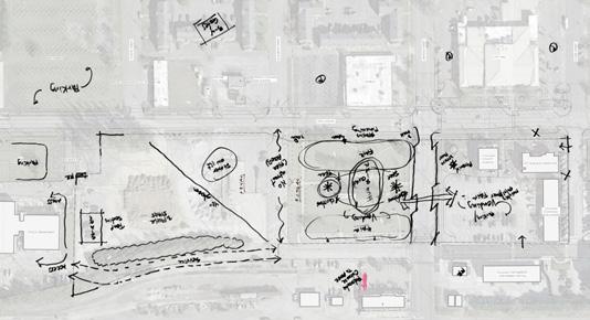
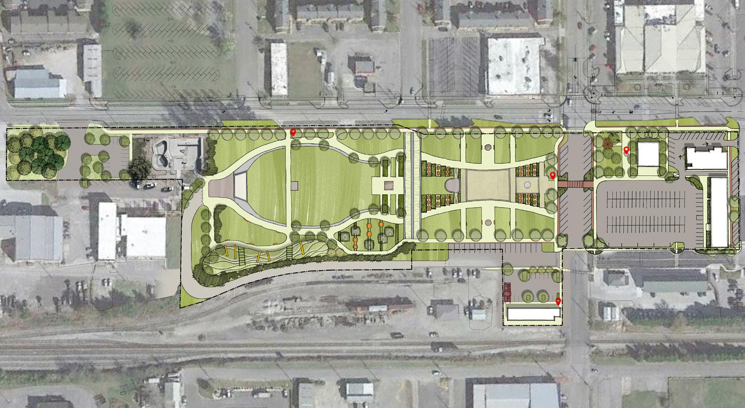
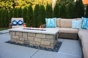
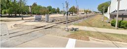
Radio Headquarter Site Area: 12.91 acres Design Scope: 3 open spaces for gatherings, 6 bio-retention areas for stormwater management, and a comprehensive landscape plan that complies with local zoning requirements. SCHEMATIC DESIGN - OVERALL SITE PLAN
OUTDOOR CAFÉ POCKET PARK
THE VALLEY
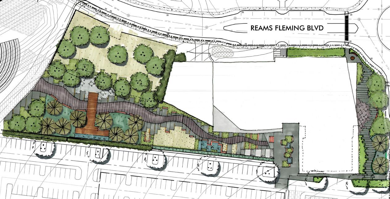

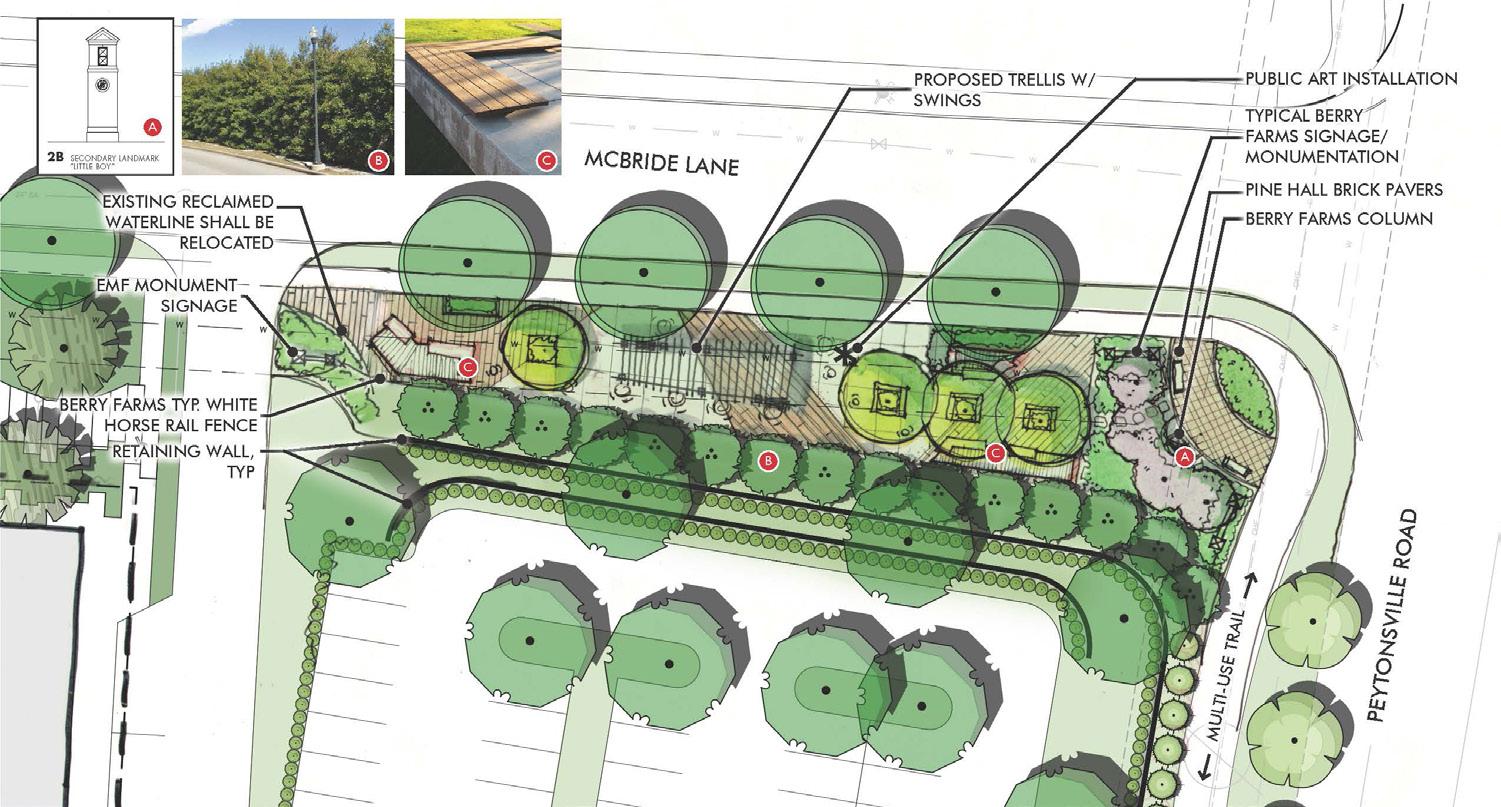
20’ X 40’ TENT TURF, TYP OUTDOOR MUSICAL INSTRUMENT CRUSHED LIMESTONE WITH 48’’ ROUND TABLES AND SEATING SERVICE PATH LANDSCAPE AREA, TYP MILENIO BENCH, TYP OUTDOOR MUSICAL INSTRUMENT Radio Headquarter Site Area: 12.91 acres Design Scope: 3 open spaces for gatherings, 6 bio-retention areas for stormwater management, and a comprehensive landscape plan that complies with local zoning requirements. SCHEMATIC DESIGN - THE VALLEY & OUTDOOR CAFÉ FRANKLIN, WILLIAMSON COUNTY, TN BERRY FARMS
FLEMING - EMF HQ 0’ 20’ 40’ 60’ SCALE: 1”=20’ REV. August 8, 2022 Project #21082 20’ X 40’ TENT TURF, TYP OUTDOOR MUSICAL INSTRUMENT CRUSHED LIMESTONE WITH 48’’ ROUND TABLES AND SEATING SERVICE PATH LANDSCAPE AREA, TYP MILENIO BENCH, TYP THE VALLEY - PHASE I OUTDOOR MUSICAL INSTRUMENT WATER PEATURE WATER PEATURE TURF, TYP OUTDOOR GATHERING OUTDOOR CAFE WALKING PATH WALKING PATH ENTRANCE PLAZA ENTRANCE
REAMS
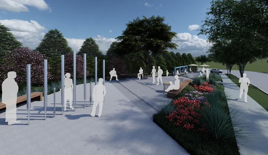
07/07/2022 6 2022 EDUCATIONAL MEDIA FOUNDATION | VALLEY UPDATE © 2022 EDUCATIONAL MEDIA FOUNDATION | VALLEY UPDATE Radio Headquarter Site Area: 12.91 acres Design Scope: 3 open spaces for gatherings, 6 bio-retention areas for stormwater management, and a comprehensive landscape plan that complies with local zoning requirements. THE VALLEY RENDERINGS
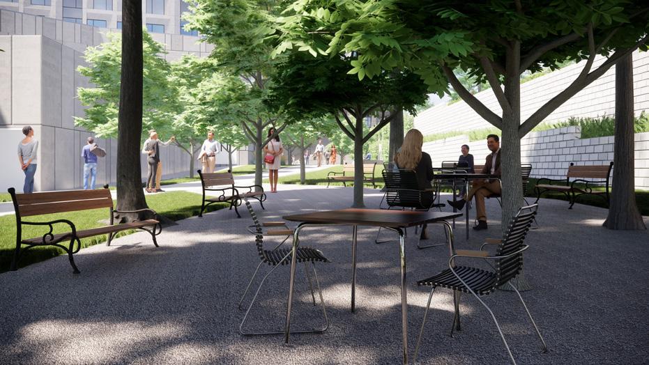
This perspective looks towards a crushed limestone area featuring tables and seating.
This perspective looks towards the main walking path in the Valley area, leading to the main building.
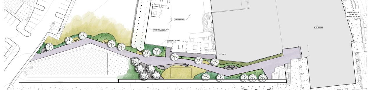
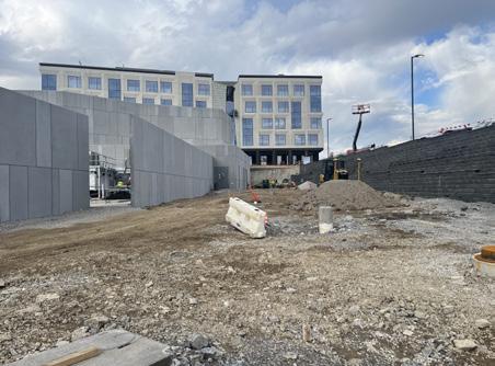
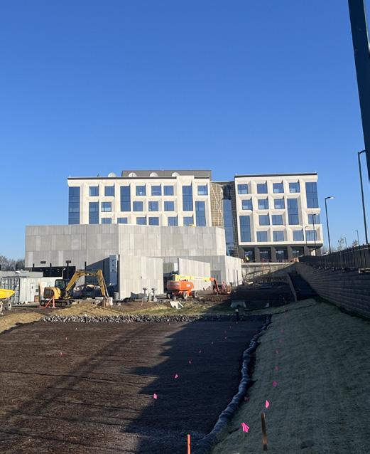
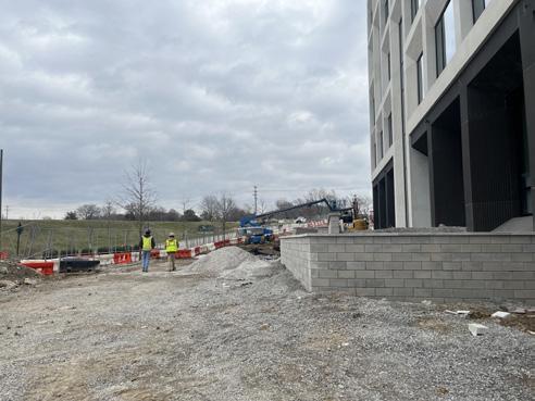
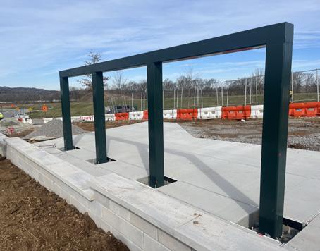
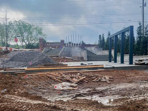
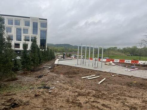
CONSTRUCTION ADMINISTRATION - THE VALLEY
CONSTRUCTION ADMINISTRATION - OUTDOOR CAFÉ
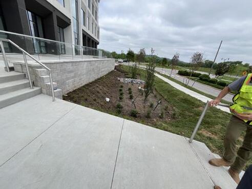
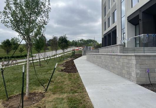
Radio Headquarter Site Area: 12.91 acres Design Scope: 3 open spaces for gatherings, 6 bio-retention areas for stormwater management, and a comprehensive landscape plan that complies with local zoning requirements.
2024-01-30 2024-02-13 2024-05-16 2024-05-16 2024-05-02 2024-02-22
Radio Headquarter Site Area: 12.91 acres Design Scope: 3 open spaces for gatherings, 6 bio-retention areas for stormwater management, and a comprehensive landscape plan that complies with local zoning requirements. SCHEMATIC DESIGN - POCKET PARK 0’ 20’ 40’ 60’ SCALE: 1”=20’ REV. August 8, 2022 Project #21082 FRANKLIN, WILLIAMSON COUNTY, TN BERRY FARMS REAMS FLEMING - EMF HQ 0’ 20’ 40’ 60’ SCALE: 1”=20’ REV. August 8, 2022 Project #21082 20’ X 40’ TENT TURF, TYP OUTDOOR MUSICAL INSTRUMENT CRUSHED LIMESTONE WITH 48’’ ROUND TABLES AND SEATING SERVICE PATH LANDSCAPE AREA, TYP MILENIO BENCH, TYP THE VALLEY - PHASE I OUTDOOR MUSICAL INSTRUMENT FRANKLIN, WILLIAMSON COUNTY, TN BERRY FARMS REAMS FLEMING - EMF HQ 0’ 20’ 40’ 60’ SCALE: 1”=20’ REV. August 8, 2022 Project #21082 20’ X 40’ TENT TURF, TYP OUTDOOR MUSICAL INSTRUMENT CRUSHED LIMESTONE WITH 48’’ ROUND TABLES AND SEATING SERVICE PATH LANDSCAPE AREA, TYP MILENIO BENCH, TYP THE VALLEY - PHASE I OUTDOOR MUSICAL INSTRUMENT 20’ 40’ 60’ REV.August 8,2022 Project #21082

Radio Headquarter Site Area: 12.91 acres Design Scope: 3 open spaces for gatherings, 6 bio-retention areas for stormwater management, and a comprehensive landscape plan that complies with local zoning requirements. POCKET PARK RENDERINGS
This perspective looks towards the musical instruments at the East entrance of the Pocket Park.
This perspective looks towards the swings at the West entrance of the Pocket Park.
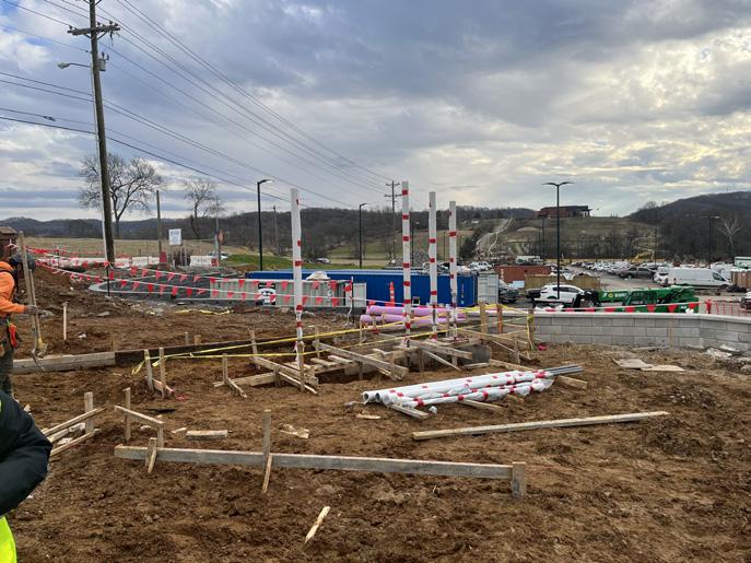
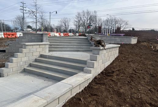
CONSTRUCTION ADMINISTRATION - POCKET PARK

Radio Headquarter Site Area: 12.91 acres Design Scope: 3 open spaces for gatherings, 6 bio-retention areas for stormwater management, and a comprehensive landscape plan that complies with local zoning requirements.
2024-04-11 The Musical Instruments
2024-01-30 The Swing and the Stairs
2024-02-29 The Stairs
2024-02-29 The Swing
2024-04-11 The Swing and the Stairs
2024-01-30 The Musical Instrument
FRANKLIN, WILLIAMSON COUNTY, TN 990 MERIDIAN 05/25/2023 Project #22008 2 - AMENITY CONCEPT B 0’ 10 20 30 SCALE: 1”=10’ 1 3 2 4 KEY: MOVEABLE SEATING CUSTOM LIGHTED COLUMN BIKE RACKS RAISED PLANTER TYP. 5 7 6 8 10 12 11 13 SYNTHETIC TURF EVENT LAWN CONCRETE WITH DECORATIVE FINISH WOOD PLANKS SCORED CONCRETE DEEP SEATING SHADE STRUCTURE DOUBLE SIDED LINEAR FOUNTAIN STEPS AND HANDRAIL 2 7 3 1 13 11 12 4 5 6 8 10 15 14 16 PATIO FENCE AND GATE (PROVIDED BY FUTURE TENANTS) VESTRE LOUNGE BENCH CUSTOM BENCH SWINGS 17 RETAINING WALL 18 BOULEVARD LANDSCAPE ENHANCEMENTS 1 4 4 5 5 5 6 7 7 11 12 14 15 16 17 18 14 16 9 9 12’ PEDESTRIAN LIGHT POLE 9 DISCLAIMER: • The drawing shown is conceptual only and for reference and illustrative purposes only. This drawing may change and should not be relied upon as a final representation of the final built project. Landscape Architect shall be onsite with contractor for final placements. CAROTHERS PARKWAY EXISTING WALL MERIDIAN BLVD COMPASS WAY EXISTING TREE, TYP. LOADING ZONE EXISTING SWITCH AND TRANSFORMER PATIO PATIO PATIO PROPOSEDBUILDING PROPOSED BUILDING CROSSWALK FRANKLIN, WILLIAMSON COUNTY, TN 990 MERIDIAN 05/25/2023 Project #22008 1 - AMENITY CONCEPT A 0’ 10 20 30 SCALE: 1”=10’ 1 3 2 4 KEY: MOVEABLE SEATING CUSTOM LIGHTED COLUMN BIKE RACKS RAISED PLANTER TYP. 5 7 6 8 10 12 11 13 SYNTHETIC TURF EVENT LAWN UNILOCK DIAMOND PAVER WOOD PLANKS SCORED CONCRETE DEEP SEATING SHADE STRUCTURE WITH STRING LIGHTS DOUBLE SIDED LINEAR FOUNTAIN STEPS AND HANDRAIL 16 14 17 PATIO FENCE AND GATE (PROVIDED BY FUTURE TENANTS) VESTRE LOUNGE BENCH CONCRETE EVENT STAGE 18 RETAINING WALL 19 BOULEVARD LANDSCAPE ENHANCEMENTS 9 CATENARY LIGHTS 1 2 3 4 6 5 7 8 9 10 11 12 13 14 16 17 1 3 4 4 7 6 5 7 12 12 18 19 15 RAISED SEATING AREA 15 15 DISCLAIMER: The drawing shown is conceptual only and for reference and illustrative purposes only. This drawing may change and should not be relied upon as a final representation of the final built project. Landscape Architect shall be onsite with contractor for final placements. CAROTHERS PARKWAY MERIDIAN BLVD COMPASS
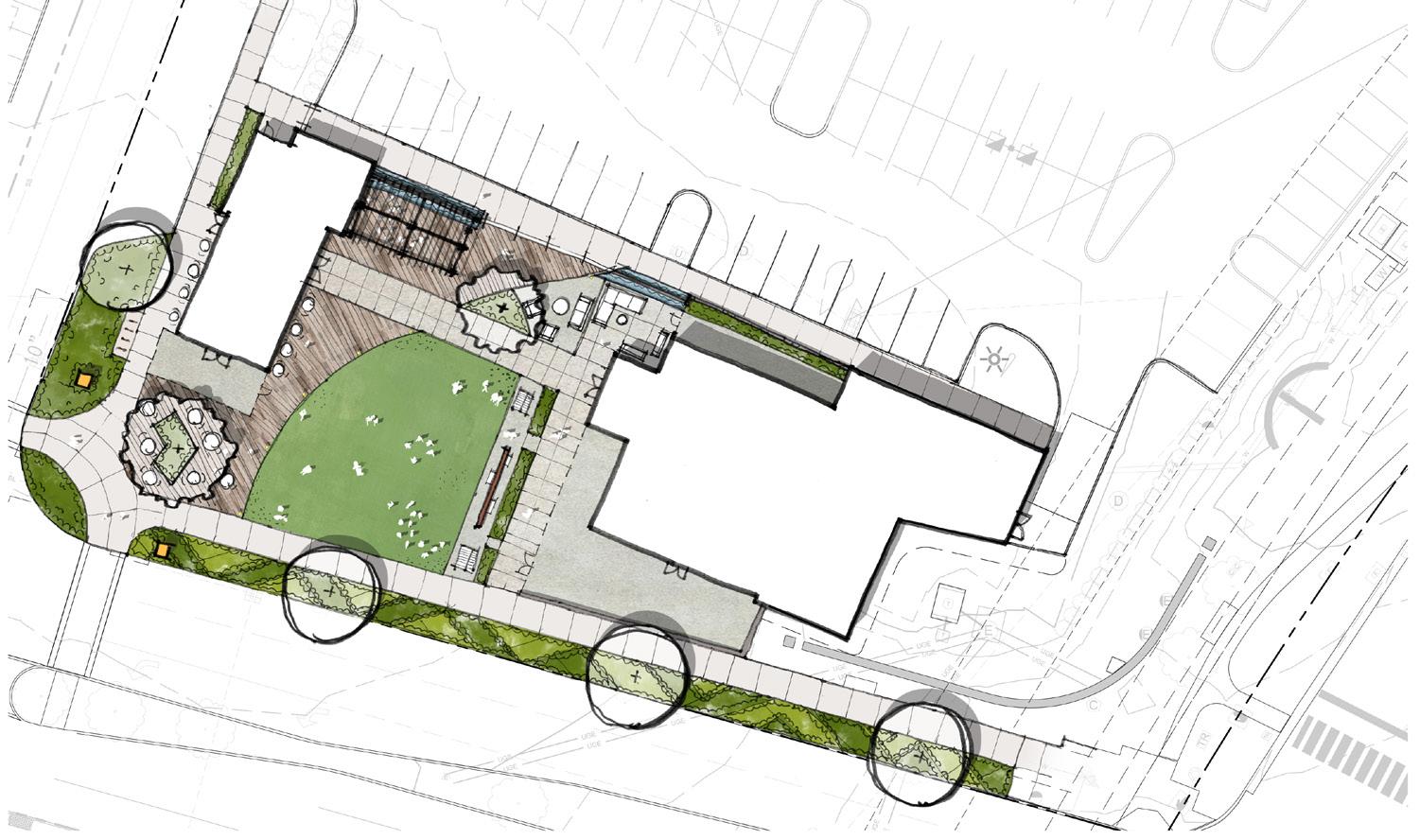
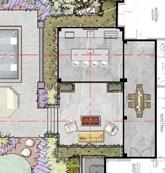
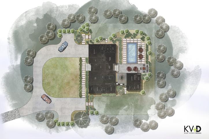
EXISTING TREE, TYP. LOADING ZONE PATIO PATIO PATIO PROPOSEDBUILDING PROPOSED BUILDING EXISTING WALL EXISTING SWITCH AND TRANSFORMER CROSSWALK FRANKLIN, WILLIAMSON COUNTY, TN 990 MERIDIAN 05/25/2023 Project #22008 1 - AMENITY CONCEPT A 0’ 10 20 30 SCALE: 1”=10’ 1 3 2 4 KEY: MOVEABLE SEATING CUSTOM LIGHTED COLUMN BIKE RACKS RAISED PLANTER TYP. 5 7 6 8 10 12 11 13 SYNTHETIC TURF EVENT LAWN UNILOCK DIAMOND PAVER WOOD PLANKS SCORED CONCRETE DEEP SEATING SHADE STRUCTURE WITH STRING LIGHTS DOUBLE SIDED LINEAR FOUNTAIN STEPS AND HANDRAIL 16 14 17 PATIO FENCE AND GATE (PROVIDED BY FUTURE TENANTS) VESTRE LOUNGE BENCH CONCRETE EVENT STAGE 18 RETAINING WALL 19 BOULEVARD LANDSCAPE ENHANCEMENTS 9 CATENARY LIGHTS 1 2 3 4 6 5 7 8 9 10 11 12 13 14 16 17 1 3 4 4 7 6 5 7 12 12 18 19 15 RAISED SEATING AREA 15 15 DISCLAIMER: The drawing shown is conceptual only and for reference and illustrative purposes only. This drawing may change and should not be relied upon as a final representation of the final built project. Landscape Architect shall be onsite with contractor for final placements. CAROTHERS PARKWAY MERIDIAN BLVD COMPASS WAY EXISTING TREE, TYP. LOADING ZONE PATIO PATIO PATIO PROPOSEDBUILDING PROPOSED BUILDING EXISTING WALL EXISTING SWITCH AND TRANSFORMER CROSSWALK OFFICE PARK Site Area: 0.75 acres Design Scope: The landscape design features functional public spaces that enhance the user experience, complementing the existing restaurant and jewel box structures. Our goal was to create a cohesive outdoor environment that promotes relaxation, social interaction, and connectivity within the office area. SCHEMATIC DESIGN - OVERALL SITE PLAN
WAY
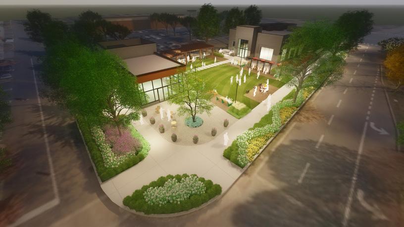
OFFICE PARK Site Area: 0.75 acres Design Scope: The landscape design features functional public spaces that enhance the user experience, complementing the existing restaurant and jewel box structures. Our goal was to create a cohesive outdoor environment that promotes relaxation, social interaction, and connectivity within the office area.
This perspective looks towards the event lawn at the outdoor patio of the restaurant.
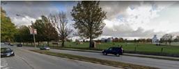
This perspective looks towards the site at the intersection of the streets.
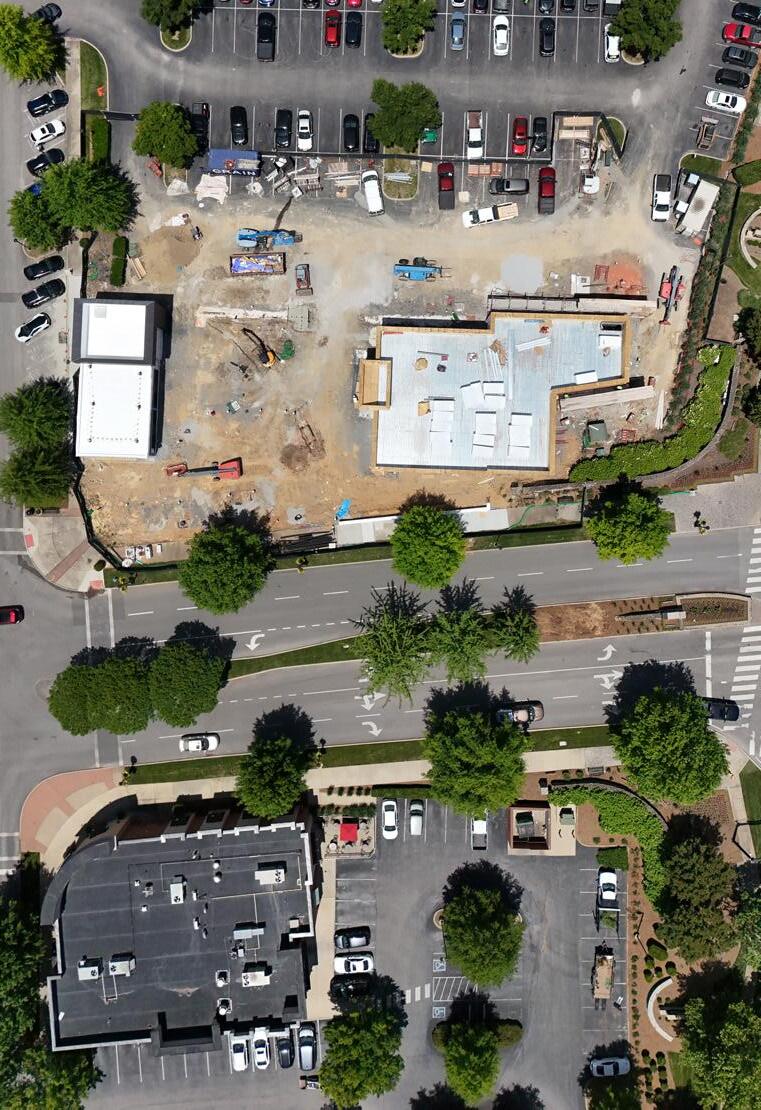
Drone photo of the construction site taken on 2024-05-31.
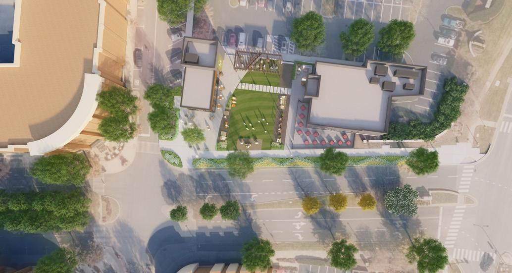
Rendered plan view of the site.
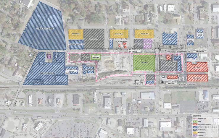
LAND USE ANALYSIS
NORTH
NORTH
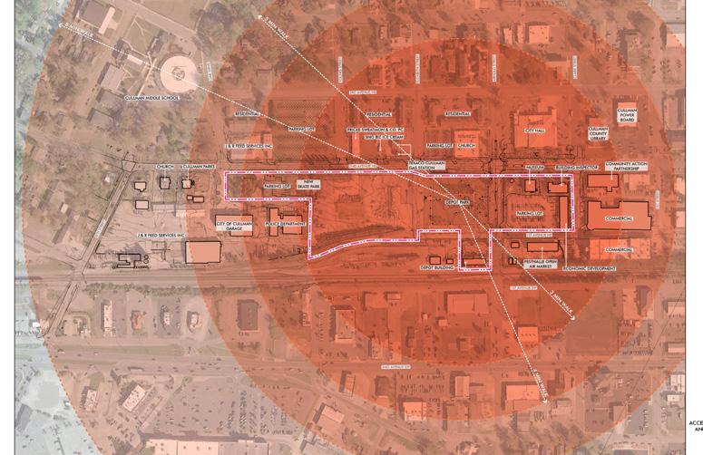
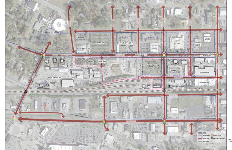
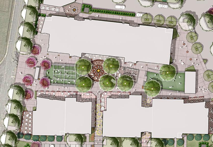
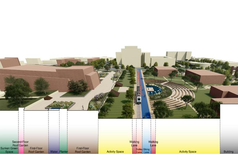
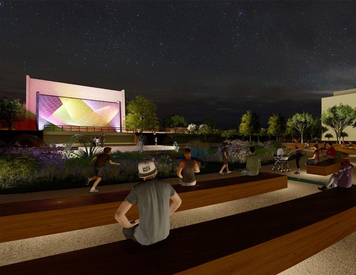
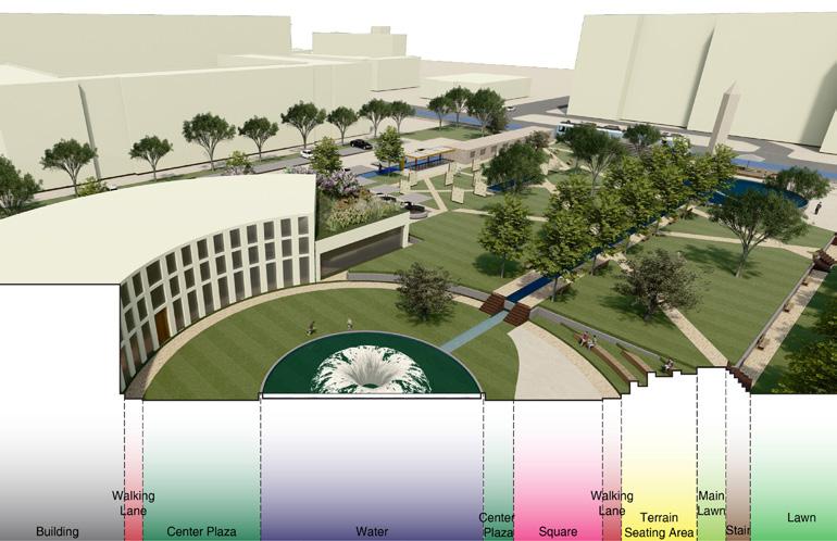
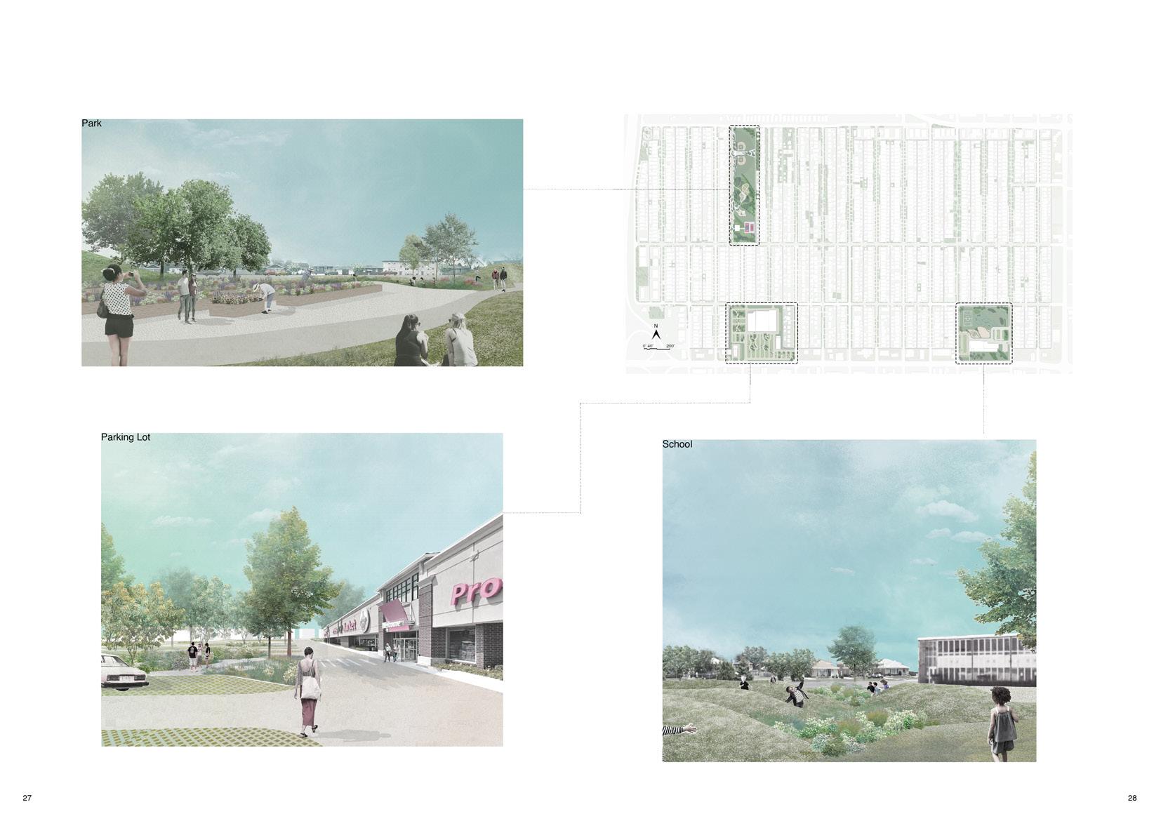
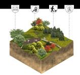
ANALYSIS NORTH ACCESSIBILITY ANALYSIS City Central Park Site Area: 12.91 acres Design Scope: The park is designed to accommodate large-scale events while providing ample space for community activities. The goal was to create a versatile and inviting urban green space that serves as a hub for both major events and everyday use by city residents. EXISTING CONDITIONS ANALYSIS
CIRCULATION
City Central Park Site Area: 12.91 acres Design Scope: The park is designed to accommodate large-scale events while providing ample space for community activities. The goal was to create a versatile and inviting urban green space that serves as a hub for both major events and everyday use by city residents.
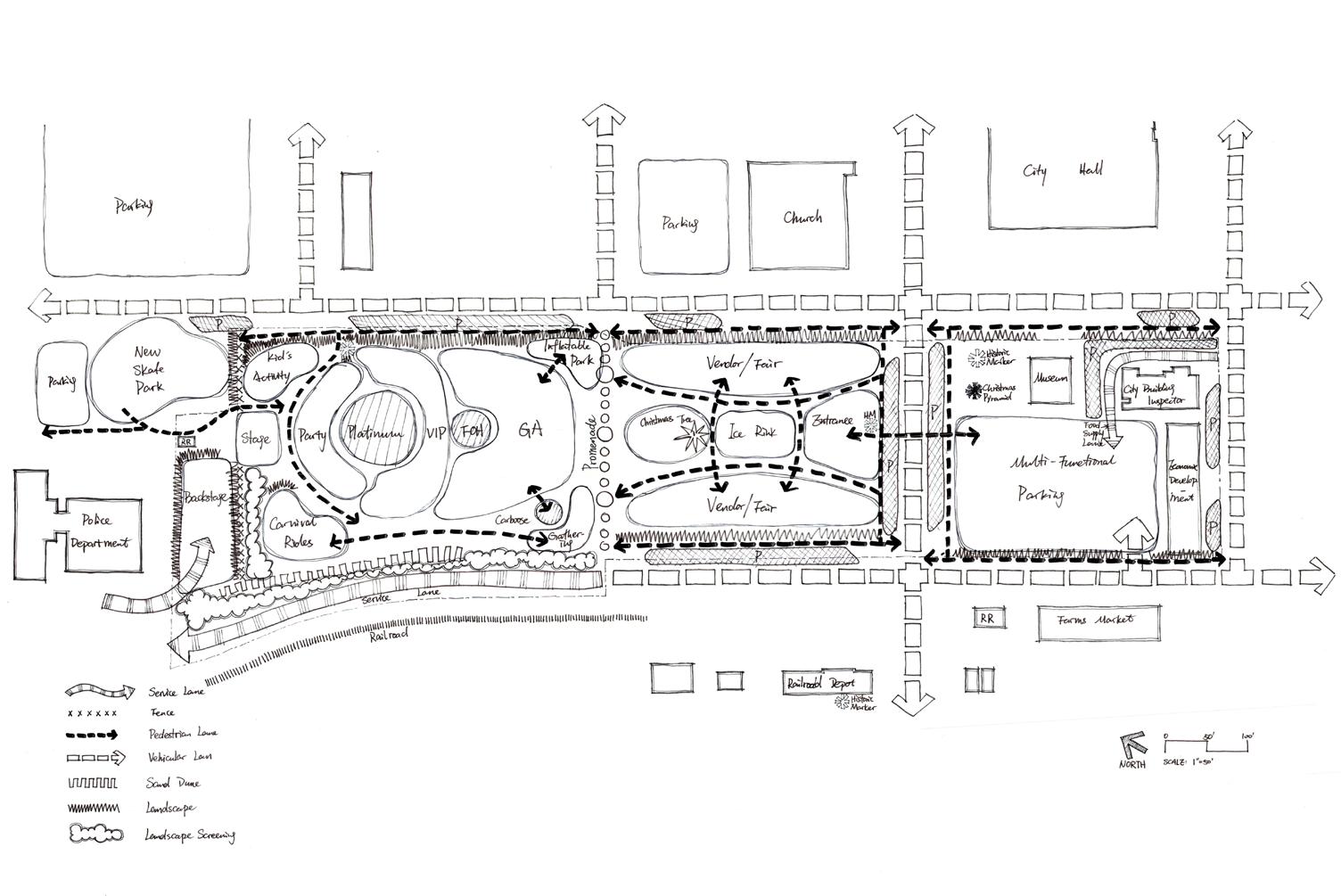
DESIGN CHARRETTE AND BUBBLE DIAGRAM
MASTER PLAN
NORTH 0 50 100 150 SCALE: 1”=100’ feet
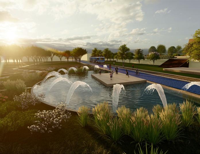
PARKING MUSEUM DEPOT BUILDING CITY BUILDING INSPECTOR ECONOMIC DEVELOPMENT THE GREAT LAWN FESTIVAL PLAZA 2ND AVENUE SE 1ST AVENUE SE LEARN / HISTORY PLAY SPACE STAGE THE GROVE ARNOLD STREET NE City Central Park Site Area: 12.91 acres Design Scope: The park is designed to accommodate large-scale events while providing ample space for community activities. The goal was to create a versatile and inviting urban green space that serves as a hub for both major events and everyday use by city residents. MASTER PLAN
PROFESSIONAL
WORKS -
02 PLANNING PROJECTS
The Planning Projects section highlights my experience in large-scale landscape planning and design. This includes master planning for urban developments, public parks, and mixed-use spaces. My planning philosophy centers on creating cohesive, sustainable, and accessible environments that enhance urban life and foster community engagement. Through thoughtful layout and strategic foresight, I aim to create spaces that are both functional and inspiring for future generations.
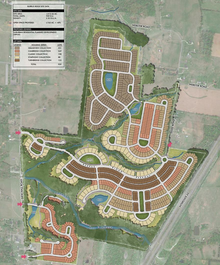
Integrated Site Planning: Balancing Building Diversity and Open Space
Project Description: This project involves planning a 412.66 AC site with various building types. The objective is to layout the site to accommodate different building types while adhering to density requirements and ensuring a specified percentage of open space. The planning process aims to create a harmonious balance between built environments and natural landscapes, optimizing land use while preserving the site's character and functionality.and functionality.
ILLUSTRATIVE RENDERING
SENIOR HOUSING
MULTI-FAMILY
TOWNHOMES
LODGING

2
SPRING
CREEK
(MIN.
MIXED-USE DISTRICT PLANNING Project Description: A specific goal of the master plan/visioning plan was to highlight pedestrian access of the site and overall community walkability, including providing opportunities for organized pedestrian network, common open spaces/streetscapes and trail connectivity. The master plan has been designed to be flexible providing opportunities for
STORY RESIDENTIAL
STORY COMMERCIAL/RETAIL
3 STORY RESIDENTIAL ABOVE 1 STORY COMMERCIAL/RETAIL & 3 STORY RESIDENTIAL ABOVE 3 STORY RESIDENTIAL 1 STORY COMMERCIAL/RETAIL & 3 STORY RESIDENTIAL ABOVE 1 STORY COMMERCIAL/RETAIL & 3 STORY RESIDENTIAL ABOVE 3 STORY RESIDENTIAL 3 STORY RESIDENTIAL 3 STORY RESIDENTIAL 3 STORY RESIDENTIAL 3 STORY SENIOR HOUSING CLUB HOUSE/AMENITY/POOL
3
1
&
OR 3 STORY
SPACE/OUTDOOR
OPEN LAWN/EVENT SPACE/OUTDOOR
DETENTION POND PROJECT SIGNAGE TRAILS TRAIL CONNECTOR TO TRACT 2 (COMMUNITY CENTER) 17 27 D 18 28 E 19 25 B 26 C 20 21 23 24 A 22 F
TOWNHOMES
16’ WIDE) ROUNDABOUT PLAZA/EVENT
DINING
DINING
PARKWAY (FUTURE) 16 17 18 19 20 21 22 23 24 25 26 27 28 A B B C C D D D D G E E E F G SITE DATA ALLOWED USES: Residential Multifamily, Residential Senior Housing, Residential Townhomes, Restaurant, Retail Shops Office, Brewery/Brewpub, Medical Office, Financial Institution, Art Gallery, Pharmacy, Apparel Shop, ATM, Bakery Retail, Barber/Beauty Shop, Café/Coffee Shop, Child Care, Consignment Store, Convenience Store, Florist, Gift/Card Shop, Jewelry Store, Laundromat, Open Space and Playgrounds APPROXIMATE DISTRICT SIZE: +/- 45.48 AC SETBACKS: Spring Creek Parkway: Minimum 25’ Mixed Use Internal Street Setbacks: 5’-15’ Townhomes: Minimum 20’ to Garage. Minimum 5’ to Main Façade
Preliminary Plans for Perimeter Buffers MAXIMUM BUILDING HEIGHT: 4 Stories OPEN SPACE: +/-17.87% Open Space MIXED-USE DISTRICT - WEST PARKING TOWNHOMES (61 UNITS): 61 Units - 122 Spaces Provided MULTI-FAMILY (260 UNITS): 260 Units - 406 Spaces Provided SENIOR HOUSING (130 UNITS): 130 Units + Employee Parking - 59 Spaces Provided COMMERCIAL/RETAIL (47,500 SF): 47,500 SF - 238 Spaces Provided PARKING REQUIRED: 824 Spaces TOTAL PARKING PROVIDED: 879 BLACK OAKS MXU-PUD DEVELOPMENT CLARKSVILLE, MONTGOMERY COUNTY, TN PROJECT# 23059 SEPTEMBER 21, 2023 PAGE: 5 0’ 100’ 200’ 300’ SCALE: 1”= 200’ SEE PAGE 4 FOR EAST ENLARGEMENT EXISTING ZONING: R2- 1&2 FAMILY RESIDENTIAL DISTRICT EXISTING ZONING: AG - AGRICULTURAL DISTRICT EXISTING ZONING: AG - AGRICULTURAL DISTRICT KEY RETAIL/COMMERCIAL MIXED-USE OFFICE SENIOR HOUSING MULTI-FAMILY TOWNHOMES LODGING 30’ AND 60’ STREAM BUFFERS, TYP. TOP OF BANK, TYP. DEVELOPMENT PLAN 16 LEGEND 3 STORY RESIDENTIAL 1 STORY COMMERCIAL/RETAIL & 3 STORY RESIDENTIAL ABOVE 1 STORY COMMERCIAL/RETAIL & 3 STORY RESIDENTIAL ABOVE 3 STORY RESIDENTIAL 1 STORY COMMERCIAL/RETAIL & 3 STORY RESIDENTIAL ABOVE 1 STORY COMMERCIAL/RETAIL & 3 STORY RESIDENTIAL ABOVE 3 STORY RESIDENTIAL 3 STORY RESIDENTIAL 3 STORY RESIDENTIAL 3 STORY RESIDENTIAL 3 STORY SENIOR HOUSING CLUB HOUSE/AMENITY/POOL 2 OR 3 STORY TOWNHOMES (MIN. 16’ WIDE) ROUNDABOUT PLAZA/EVENT SPACE/OUTDOOR DINING OPEN LAWN/EVENT
DETENTION POND PROJECT SIGNAGE TRAILS TRAIL CONNECTOR TO TRACT 2 (COMMUNITY CENTER) 17 27 D 18 28 E 19 25 B 26 C 20 21 23 24 A 22 F SPRING
PARKWAY (FUTURE) 16 17 18 19 20 21 22 23 24 25 26 27 28 A B B C C D D D D G E E E F G SITE DATA
Restaurant, Retail Shops Office, Brewery/Brewpub, Medical Office, Financial Institution, Art Gallery, Pharmacy, Apparel Shop, ATM, Bakery Retail, Barber/Beauty Shop, Café/Coffee Shop, Child Care, Consignment Store,
Store, Florist, Gift/Card Shop, Jewelry Store, Laundromat, Open Space and Playgrounds APPROXIMATE DISTRICT SIZE: +/- 45.48 AC SETBACKS: Spring Creek Parkway: Minimum 25’ Mixed Use Internal Street Setbacks: 5’-15’ Townhomes: Minimum 20’ to Garage. Minimum 5’ to Main Façade See Preliminary Plans for Perimeter Buffers MAXIMUM BUILDING HEIGHT: 4 Stories OPEN SPACE: +/-17.87% Open Space MIXED-USE DISTRICT - WEST PARKING TOWNHOMES (61 UNITS): 61 Units - 122 Spaces Provided MULTI-FAMILY (260 UNITS): 260 Units - 406 Spaces Provided SENIOR HOUSING (130 UNITS): 130 Units + Employee Parking - 59 Spaces Provided COMMERCIAL/RETAIL (47,500 SF): 47,500 SF - 238 Spaces Provided PARKING REQUIRED:
Spaces TOTAL PARKING PROVIDED:
BLACK OAKS MXU-PUD DEVELOPMENT CLARKSVILLE, MONTGOMERY COUNTY, TN PROJECT# 23059 SEPTEMBER 21, 2023 PAGE: 5 0’ 100’ 200’ 300’ SCALE: 1”= 200’ SEE PAGE 4 FOR EAST ENLARGEMENT EXISTING ZONING:
1&2 FAMILY RESIDENTIAL DISTRICT EXISTING
- AGRICULTURAL DISTRICT EXISTING
AG - AGRICULTURAL DISTRICT KEY
See
SPACE/OUTDOOR DINING
CREEK
ALLOWED USES: Residential Multifamily, Residential Senior Housing, Residential Townhomes,
Convenience
824
879
R2-
ZONING: AG
ZONING:
RETAIL/COMMERCIAL MIXED-USE OFFICE
30’ AND 60’ STREAM BUFFERS, TYP. TOP OF BANK, TYP.
1 STORY OFFICE
1 STORY COMMERCIAL/RETAIL
1 STORY COMMERCIAL/RETAIL
1 STORY COMMERCIAL/RETAIL
1 STORY COMMERCIAL/RETAIL
1 STORY JEWEL BOX - RETAIL/RESTAURANT
1 STORY COMMERCIAL/RETAIL
1 STORY COMMERCIAL/RETAIL & 1 STORY OFFICE/RESIDENTIAL ABOVE
1 STORY COMMERCIAL/RETAIL
1 STORY COMMERCIAL/RETAIL
LODGING
1
1 STORY COMMERCIAL/RETAIL
1 STORY COMMERCIAL/RETAIL ROUNDABOUT
PLAZA/EVENT SPACE/OUTDOOR DINING
DINING
OPEN LAWN/EVENT SPACE/OUTDOOR DINING
DETENTION POND
ALLOWABLE USES: Residential Multifamily, Restaurant, Retail Shops,
DEVELOPMENT PLAN
STORY
STORY COMMERCIAL/RETAIL
1 STORY OFFICE/RESIDENTIAL ABOVE
COMMERCIAL/RETAIL 1
&
1 STORY COMMERCIAL/RETAIL
PROJECT
LEGEND 1 2 12 D 3 13 4 10 B 11 C 5 6 8 9 A 7 14 15 1 2 3 4 5 6 7 8 9 10 11 12 13 14 15 A B C B B D D D SPRING CREEK PARKWAY (FUTURE) E E E E SITE DATA
SIGNAGE
Financial Institution, Art Gallery,
ATM, Liquor Sales, Bakery
Bar,
Shop, Café/Coffee
Care,
Store,
Store,
Gift/Card Shop, Jewelry Store, Open Space and Playgrounds APPROXIMATE DISTRICT SIZE: +/- 28.83 AC SETBACKS: Spring Creek Parkway: Min. 25’ Mixed-Use Internal Street: 5’-15’ See Preliminary Plans for Perimeter
MAXIMUM BUILDING HEIGHT: 4 Stories OPEN SPACE: +/- 6.19% Open Space MIXED-USE DISTRICT - EAST PARKING MULTI-FAMILY (38 Units): 38 Units - 47 Spaces Provided *Note: 20% Reduction Applied RETAIL/COMMERCIAL (146,140 SF): 146,140 SF - 585 Spaces Provided *Note: 20% Reduction Applied OFFICE (15,000 SF): 15,000 SF - 36 Spaces Provided *Note: 20% Reduction Applied OFFICE/COMMERCIAL (41,640 SF): 41,640 SF - 333 Spaces Provided *Note: 20% Reduction Applied PARKING REQUIRED: 1,001 Spaces TOTAL PARKING PROVIDED: 1,074 Spaces BLACK OAKS MXU-PUD DEVELOPMENT CLARKSVILLE, MONTGOMERY COUNTY, TN PROJECT# 23059 SEPTEMBER 21, 2023 PAGE: 4 0’ 100’ 200’ 300’ SCALE: 1”= 200’ SEE PAGE 5 FOR WEST ENLARGEMENT EXISTING ZONING: AG - AGRICULTURAL DISTRICT EXISTING ZONING: AG - AGRICULTURAL DISTRICT EXISTING ZONING: AG - AGRICULTURAL DISTRICT KEY RETAIL/COMMERCIAL MIXED-USE OFFICE SENIOR HOUSING MULTI-FAMILY TOWNHOMES LODGING 30’ AND 60’ STREAM BUFFERS, TYP. TOP OF BANK, TYP. 16 LEGEND 3 STORY RESIDENTIAL 1 STORY COMMERCIAL/RETAIL & 3 STORY RESIDENTIAL ABOVE 1 STORY COMMERCIAL/RETAIL & 3 STORY RESIDENTIAL ABOVE 3 STORY RESIDENTIAL 1 STORY COMMERCIAL/RETAIL & 3 STORY RESIDENTIAL ABOVE 1 STORY COMMERCIAL/RETAIL & 3 STORY RESIDENTIAL ABOVE 3 STORY RESIDENTIAL 3 STORY RESIDENTIAL 3 STORY RESIDENTIAL 3 STORY RESIDENTIAL 3 STORY SENIOR HOUSING CLUB HOUSE/AMENITY/POOL 2 OR 3 STORY TOWNHOMES (MIN. 16’ WIDE) ROUNDABOUT PLAZA/EVENT SPACE/OUTDOOR
PROJECT SIGNAGE TRAILS TRAIL CONNECTOR TO TRACT 2
CENTER) 17 27 D 18 28 E 19 25 B 26 C 20 21 23 24 A 22 F SPRING CREEK PARKWAY (FUTURE) 16 17 18 19 20 21 22 23 24 25 26 27 28 A B B C C D D D D G E E E F G SITE DATA
Residential Townhomes, Restaurant, Retail Shops Office, Brewery/Brewpub, Medical Office, Financial Institution, Art Gallery, Pharmacy, Apparel Shop, ATM, Bakery Retail, Barber/Beauty Shop, Café/Coffee Shop, Child Care, Consignment Store, Convenience Store, Florist, Gift/Card Shop, Jewelry Store, Laundromat, Open Space and Playgrounds APPROXIMATE DISTRICT SIZE: +/- 45.48 AC SETBACKS: Spring Creek Parkway: Minimum 25’ Mixed Use Internal Street Setbacks: 5’-15’ Townhomes: Minimum 20’ to Garage. Minimum 5’ to Main Façade See Preliminary Plans for Perimeter Buffers MAXIMUM BUILDING HEIGHT: 4 Stories OPEN SPACE: +/-17.87% Open Space MIXED-USE DISTRICT - WEST PARKING TOWNHOMES (61 UNITS): 61 Units - 122 Spaces Provided MULTI-FAMILY (260 UNITS): 260 Units - 406 Spaces Provided SENIOR HOUSING (130 UNITS): 130 Units + Employee Parking - 59 Spaces Provided COMMERCIAL/RETAIL (47,500 SF): 47,500 SF - 238 Spaces Provided PARKING REQUIRED: 824 Spaces TOTAL PARKING PROVIDED: 879
MXU-PUD DEVELOPMENT CLARKSVILLE, MONTGOMERY COUNTY, TN PROJECT# 23059 SEPTEMBER 21, 2023 PAGE: 5 0’ 100’ 200’ 300’ SCALE: 1”= 200’ SEE PAGE 4 FOR EAST ENLARGEMENT EXISTING ZONING: R2- 1&2 FAMILY RESIDENTIAL DISTRICT EXISTING ZONING: AG - AGRICULTURAL DISTRICT EXISTING ZONING: AG - AGRICULTURAL DISTRICT KEY RETAIL/COMMERCIAL MIXED-USE OFFICE
HOUSING
Office, Brewery/Brewpub, Medical Office,
Pharmacy, Apparel Shop,
Retail,
Barber/Beauty
Shop, Child
Consignment
Convenience
Florist,
Buffers
DINING OPEN LAWN/EVENT SPACE/OUTDOOR
DETENTION POND
(COMMUNITY
ALLOWED USES: Residential Multifamily, Residential Senior Housing,
BLACK OAKS
SENIOR
MULTI-FAMILY TOWNHOMES
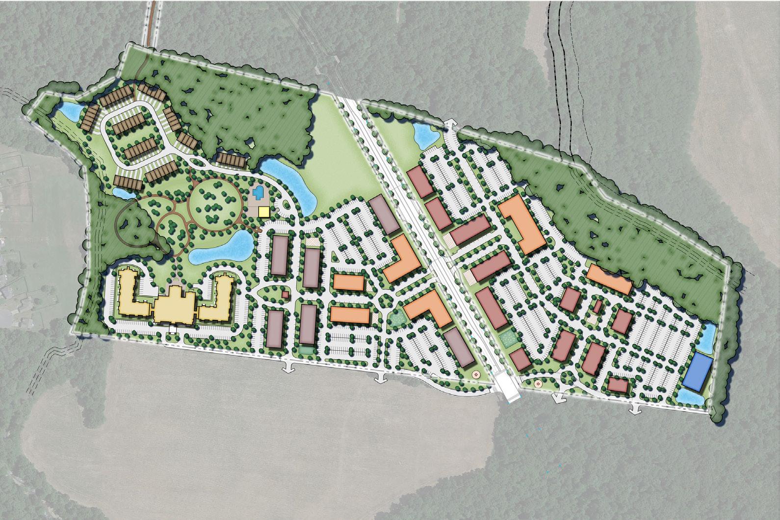
30’ AND 60’ STREAM BUFFERS, TYP. TOP OF BANK, TYP. MIXED-USE DISTRICT PLANNING Project Description: A specific goal of the master plan/visioning plan was to highlight pedestrian access of the site and overall community walkability, including providing opportunities for organized pedestrian network, common open spaces/streetscapes and trail connectivity. The master plan has been designed to be flexible providing opportunities for multiple uses within an organized street network which should serve as a vision to guide development of the site.
PROFESSIONAL WORKS -
RESIDENTIAL PROJECTS
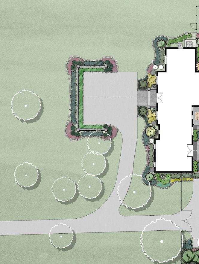
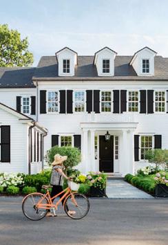
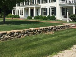
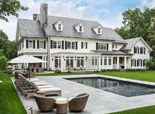
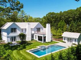
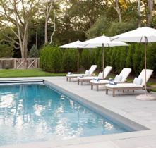
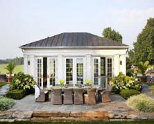
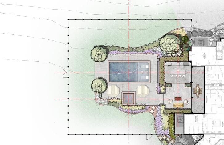
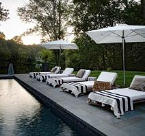
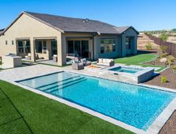
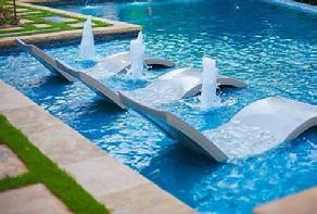
In the Residential Projects section, you will see my passion for transforming private outdoor spaces into personal sanctuaries. I work closely with homeowners to understand their visions and needs, crafting bespoke landscapes that enhance their living experience. From intimate gardens to expansive estates, my designs prioritize beauty, comfort, and harmony with nature. Each project reflects a tailored approach to creating outdoor spaces that are as unique as the people who inhabit them.
03

NEW LIMESTONE CHIP AGGREGATE DRIVEWAY NEW GUEST PARKING AREA
COBBLESTONE
COBBLESTONE
EXISTING
FRANKLIN, WILLIAMSON COUNTY, TN
WEELDEN
12/15/2021 Project #21090 DISCLAIMER: The drawing shown is conceptual only and for reference and illustrative purposes only. This drawing may change and should not be relied upon as a final representation of the final built project. Site base information was provided by the homewowner and site visit measurements performed by KVD on 21-11-12. 0’ 10 20 30 SCALE: 1”=10’ 2 - FRONT YARD CONCEPT PLAN 1 3 2 5 6 7 8 8 4 7 9 KEY: 1 9 5 3 7 2 6 4 8 FRONT PORCH WITH BLUESTONE PAVERS AND STEPS BLUESTONE PAVER WALKWAY
LIMESTONE
(TO BE CENTERED WITH THE FRONT DOOR) 30” HT. FREESTANDING
WITH COLUMNS TO WRAP AROUND THE GUEST PARKING
EXISTING TREES
VAN
RESIDENCE
NEW
CHIP AGGREGATE DRIVEWAY NEW GUEST PARKING AREA
STONE WALL
AREA
EDGER AROUND LANDSCAPE
REMOVE/RELOCATE TREES THAT DIRECTLY BLOCK VIEW TO THE FRONT DOOR OF THE HOUSE FROM DEERFIELD LANE STONE COLUMNS WITH CHEEK WALLS CENTER LINE OF FRONT DOOR SEE SHEET 3REAR YARD CONCEPT PLAN FRANKLIN, WILLIAMSON COUNTY, TN
WEELDEN RESIDENCE 12/15/2021 Project #21090 DISCLAIMER: The drawing shown is conceptual only and for reference and illustrative purposes only. This drawing may change and should not be relied upon as a final representation of the final built project. Site base information was provided by the homewowner and site visit measurements performed by KVD on 21-11-12. 0’ 10 20 30 SCALE: 1”=10’ 2 - FRONT YARD CONCEPT PLAN 1 3 2 5 6 7 8 8 4 7 9 KEY: 1 9 5 3 7 2 6 4 8 FRONT PORCH
BEDS
VAN
WITH BLUESTONE PAVERS AND STEPS BLUESTONE PAVER WALKWAY
BE CENTERED
THE
DOOR) 30” HT. FREESTANDING
WITH
TO WRAP AROUND THE GUEST PARKING AREA
(TO
WITH
FRONT
STONE WALL
COLUMNS
TREES
AROUND LANDSCAPE
THAT DIRECTLY BLOCK VIEW TO THE FRONT DOOR OF THE HOUSE FROM DEERFIELD LANE STONE
CENTER LINE OF FRONT DOOR SEE SHEET 3REAR YARD CONCEPT PLAN DYNAMIC FAMILY RESIDENCE CONCEPTUAL LANDSCAPE PLAN - FRONT YARD
EDGER
BEDS REMOVE/RELOCATE TREES
COLUMNS WITH CHEEK WALLS
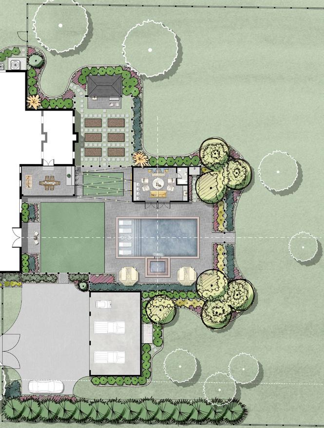
KEY:
GARDEN SHED (EXISTING STORAGE SHED - RELOCATED)
GARDEN SHED PATIO (+/- 6’ x 16’ )
+/- 10’ x 12’ HOT TUB WITH BENCH SEATING (HOT TUB WITH SPILLWAY INTO THE POOL)
COBBLESTONE EDGER AROUND THE BLUESTONE PATIOS AND LANDSCAPE BEDS
FENCE/GATES AROUND THE GARDEN
HOUSE ADDITION (15’ EXPANSION)
+/- 14’ x 25’ COVERED BLUESTONE PATIO WITH A HANGING DAYBED (COVERED ROOF LINE TO BE ATTACHED TO HOUSE)
OUTDOOR KITCHEN WITH BAR HEIGHT SEATING
FAMILY ACTIVITY SPACE WITH SYNTHETIC TURF AND STRING LIGHTING
MOVIE PROJECTION WALL
+/- 17’ x 27’ INDOOR/OUTDOOR POOL HOUSE WITH COFFEE BAR AND BATHROOM
FIREPLACE WITH LOUNGE FURNITURE
OUTDOOR SHOWER WITH A BLUESTONE STEPPER WALKWAY
SMALL BLUESTONE PATIO (+/- 9’ x 15’ )
OPEN LAWN WITH SYNTHETIC TURF
+/- 20’ x 40’ POOL WITH AN 8’
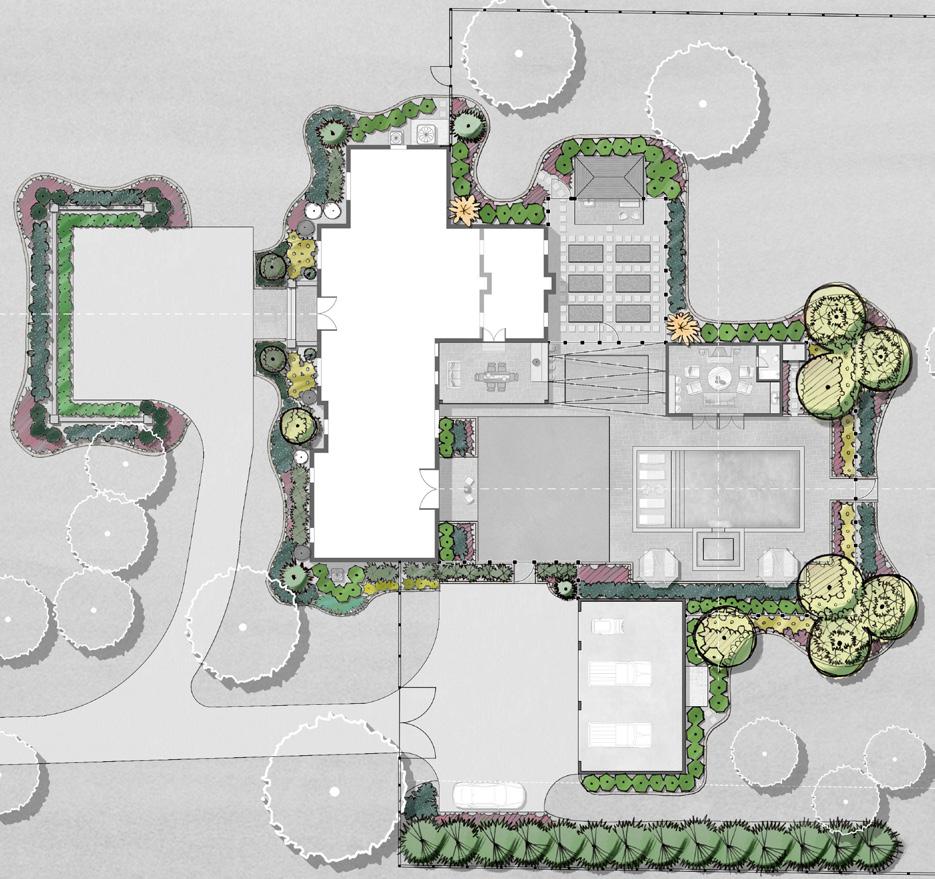
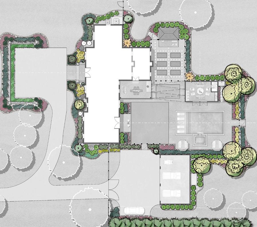
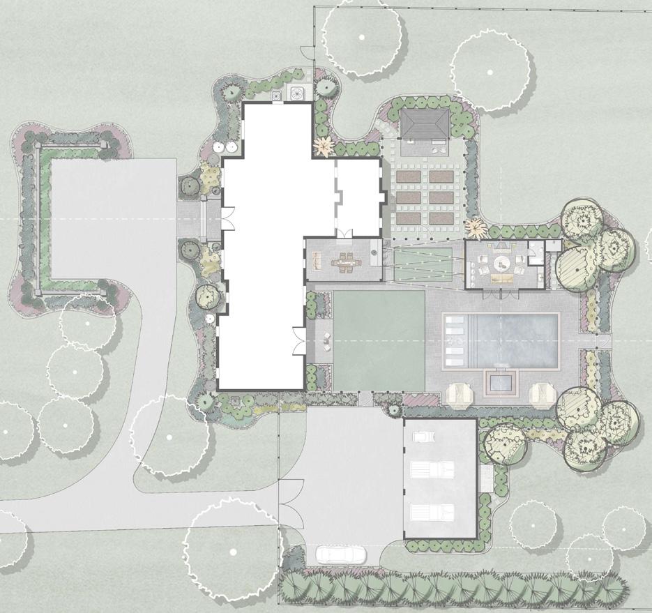
VAN WEELDEN RESIDENCE
DECK LOUNGE FURNITURE WITH UMBRELLAS
48’ HTPOOL FENCING WITH SELF CLOSING GATES, PER LOCAL CODES
WALKWAY WITH GATE TO ACCESS THE GARAGE AND DRIVEWAY
25’ x 41’ GARAGE WITH SECOND FLOOR GUEST QUARTERS
GUEST PARKING / TURN AROUND AREA
FRANKLIN, WILLIAMSON COUNTY, TN
12/15/2021 Project #21090 DISCLAIMER: The drawing shown is conceptual only and for reference and illustrative purposes only. This drawing may change and should not be relied upon as a final representation of the final built project. Site base information was provided by the homewowner and site visit measurements performed by KVD on 21-11-12. 3 - REAR YARD CONCEPT PLAN 0’ 10 20 30 SCALE: 1”=10’ MINIMUM BUILDING SETBACK LINE CENTER LINE OFF DOOR CENTER LINE FUTURE ADDITION 1 2 3 8 7 9 11 10 12 13 14 15 16 17 19 23 24 25 1 9 23 5 19 13 27 3 11 25 7 21 15 30 29 17 2 10 24 6 20 14 28 4 12 26 8 22 16 18
SUNSHELF WITH CHAISE
EXISTING
POOL
+/-
BLUESTONE PAVER POOL DECK WALKWAY WITH GATE TO ACCESS THE REST OF THE REAR YARD POOL EQUIPMENT AND STORAGE EVERGREEN TREE PRIVACY SCREENING BLUESTONE STEPPERS EXISTING TREES PROPOSED LANDSCAPING GARDEN WITH RAISED PLANTER BEDS AND BLUESTONE STEPPERS IN DECORATIVE GRAVEL 4 5 6 28 28 27 18 20 21 18 20 22 26 26 29 29 SEE SHEET 2FRONT YARD CONCEPT PLAN SEE SHEET 5PLAY ZONE CONCEPT PLAN 30 30 FRANKLIN, WILLIAMSON COUNTY, TN VAN WEELDEN RESIDENCE 12/15/2021 Project #21090 DISCLAIMER: The drawing shown is conceptual only and for reference and illustrative purposes only. This drawing may change and should not be relied upon as a final representation of the final built project. Site base information was provided by the homewowner and site visit measurements performed by KVD on 21-11-12. 0’ 10 20 30 SCALE: 1”=10’ 2 - FRONT YARD CONCEPT PLAN 1 3 2 5 6 7 8 8 4 7 9 KEY: 1 9 5 3 7 2 6 4 8 FRONT PORCH WITH BLUESTONE PAVERS AND STEPS BLUESTONE PAVER WALKWAY NEW LIMESTONE CHIP AGGREGATE DRIVEWAY NEW GUEST PARKING AREA (TO BE CENTERED WITH THE FRONT DOOR) 30” HT. FREESTANDING STONE WALL WITH COLUMNS TO WRAP AROUND THE GUEST PARKING AREA EXISTING TREES
EDGER AROUND LANDSCAPE BEDS REMOVE/RELOCATE TREES THAT DIRECTLY BLOCK VIEW TO THE FRONT DOOR OF THE HOUSE FROM DEERFIELD LANE STONE COLUMNS WITH CHEEK WALLS CENTER LINE OF FRONT DOOR SEE SHEET 3REAR YARD CONCEPT PLAN CONCEPTUAL LANDSCAPE PLAN - BACK YARD DYNAMIC FAMILY RESIDENCE
WIDE
LOUNGE FURNITURE
FENCE AND GATE
COBBLESTONE
PLANTING KEY:
EVERGREEN TREES OPTIONS
• TEDDY BEAR MAGNOLIA
PLANTING KEY:
• GREEN GIANT ARBORVITAE
EVERGREEN COLUMNAR TREES OPTIONS
EVERGREEN TREES/SCREENING OPTIONS
• EMERALD ARBORVITAE
• TEDDY BEAR MAGNOLIA
• TAYLOR JUNIPER
• GREEN GIANT ARBORVITAE
EVERGREEN COLUMNAR TREES OPTIONS
FLOWERING ORNAMENTAL TREE OPTIONS
• NATCHEZ CRAPE MYRTLE
• EMERALD ARBORVITAE
• TAYLOR JUNIPER
• AUTUMN BRILLIANCE SERVICEBERRY
FLOWERING ORNAMENTAL TREE OPTIONS
SMALL FLOWERING ORNAMENTAL TREE OPTIONS
• NATCHEZ CRAPE MYRTLE
• AUTUMN BRILLIANCE SERVICEBERRY
• LIMELIGHT HYDRANGEA (TREE FORM)
• DAPPLE WILLOW (TREE FORM)
SMALL FLOWERING ORNAMENTAL TREE OPTIONS
• LIMELIGHT HYDRANGEA (TREE FORM)
EVERGREEN FOUNDATION/LOW SHRUB OPTIONS
• DENSE YEW
• DAPPLE WILLOW (TREE FORM)
• OTTO LUYKEN LAUREL
EVERGREEN FOUNDATION/LOW SHRUB OPTIONS
• DENSE YEW
• OTTO LUYKEN LAUREL
EVERGREEN SCREENING SHRUB OPTIONS
• SKIP LAURELS
EVERGREEN SCREENING SHRUB OPTIONS
• HICKI YEW
• SKIP LAURELS
• HICKI YEW
EVERGREEN HEDGE PLANT OPTIONS
EVERGREEN HEDGE OPTIONS
• BABY GEM BOXWOOD
• BABY GEM BOXWOOD
• HOOGENDORN HOLLY
• HOOGENDORN HOLLY
EVERGREEN SHRUBS OPTIONS
EVERGREEN SHRUBS OPTIONS
• WINTERGREEN BOXWOOD
• WINTERGREEN BOXWOOD
• CHESTNUT HILL LAUREL
• CHESTNUT HILL LAUREL
LARGE FLOWERING SHRUB OPTIONS
• LIMELIGHT HYDRANGEA
LARGE FLOWERING SHRUB OPTIONS
• LIMELIGHT LIGHT HYDRANGEA
• JUDDI VIBURNUM
• JUDDI VIBURNUM
FLOWERING SHRUB OPTIONS
• BOBO HYDRANGEA
FLOWERING SHRUB OPTIONS
• ENCORE AZELEA
• BOBO HYDRANGEA
• DRIFT ROSE
• ENCORE AZELEA
• DRIFT ROSE
FLOWERING PERENNIAL OPTIONS
• WALKER’S LOW CATMINT
• PINK PANTHER CORAL BELL
FLOWERING PERENNIAL OPTIONS
• WALKER’S LOW CATMINT
• PINK PANTHER CORAL BELL
GROUNDCOVER OPTIONS
• VARIGATED LIRIOPE
• LAMB’S EAR
GROUNDCOVER OPTIONS
• HOSTAS
• VARIGATED LIRIOPE
• LAMB’S EAR
HOSTAS
FRANKLIN, WILLIAMSON COUNTY, TN
12/15/2021 Project #21090 DISCLAIMER: The drawing shown is conceptual only and for reference and illustrative purposes only. This drawing may change and should not be relied upon as a final representation of the final built project. Site base information was provided by the homewowner and site visit measurements performed by KVD on 21-11-12. 7 - LANDSCAPE CONCEPT PLAN 0’ 10 20 30 SCALE: 1”=10’ LANDSCAPE PLAN CONCEPT
VAN WEELDEN RESIDENCE
•
EVERGREEN HEDGE EVERGREEN SHRUBS RELOCATED ARBORVITAE GROUNDCOVER EVERGREEN HEDGE COLUMNAR EVERGREEN TREE EVERGREEN FOUNDATION SHRUB RELOCATED ARBORVITAE EXISTING ARBORVITAE RELOCATED ARBORVITAE FLOWERING PERENNIALS EVERGREEN TREE FLOWERING SHRUBS GROUNDCOVER EVERGREEN SCREENING SHRUBS GROUNDCOVER LOW EVERGREEN SHRUBS EVERGREEN FOUNDATION SHRUBS FLOWERING PERENNIALS FLOWERING PERENNIALS FLOWERING SHRUBS EVERGREEN SCREENING SHRUBS LOW EVERGREEN SHRUBS LOW EVERGREEN SHRUBS LOW EVERGREEN SHRUBS LOW EVERGREEN SHRUBS EVERGREEN SCREENING SHRUBS LARGE FLOWING SHRUB FLOWERING PERENNIAL FLOWERING ORNAMENTAL TREE FLOWERING SHRUBS FLOWERING PERENNIALS EVERGREEN TREE SCREENING FLOWERING SHRUBS FLOWERING SHRUBS FLOWERING SHRUBS FLOWERING SHRUBS EVERGREEN FOUNDATION SHRUBS FLOWERING PERENNIALS EVERGREEN SCREENING SHRUBS EVERGREEN TREES SMALL ORNAMENTAL TREES EXISTING ARBORVITAE COLUMNAR EVERGREEN TREE FLOWERING ORNAMENTAL TREES FLOWERING ORNAMENTAL TREES GROUNDCOVER FLOWERING SHRUBS FLOWERING SHRUBS FLOWERING PERENNIALS EVERGREEN FOUNDATION SHRUB EVERGREEN HEDGE EVERGREEN FOUNDATION SHRUB LARGE FLOWING SHRUB EVERGREEN SCREENING SHRUBS FLOWERING PERENNIALS FLOWERING PERENNIALS
FRANKLIN, WILLIAMSON COUNTY, TN VAN WEELDEN RESIDENCE 12/15/2021 Project #21090 DISCLAIMER: The drawing shown is conceptual only and for reference and illustrative purposes only. This drawing may change and should not be relied upon as a final representation of the final built project. Site base information was provided by the homewowner and site visit measurements performed by KVD on 21-11-12. 0’ 10 20 30 SCALE: 1”=10’ 2 - FRONT YARD CONCEPT PLAN 1 3 2 5 6 7 8 8 4 7 9 KEY: 1 9 5 3 7 2 6 4 8 FRONT PORCH WITH BLUESTONE PAVERS AND STEPS BLUESTONE PAVER WALKWAY NEW LIMESTONE CHIP AGGREGATE DRIVEWAY NEW GUEST PARKING AREA (TO BE CENTERED WITH THE FRONT DOOR) 30” HT. FREESTANDING STONE WALL WITH COLUMNS TO WRAP AROUND THE GUEST PARKING AREA EXISTING TREES COBBLESTONE EDGER AROUND LANDSCAPE BEDS REMOVE/RELOCATE TREES THAT DIRECTLY BLOCK VIEW TO THE FRONT DOOR OF THE HOUSE FROM DEERFIELD LANE STONE COLUMNS WITH CHEEK WALLS CENTER LINE OF FRONT DOOR SEE SHEET 3REAR YARD CONCEPT PLAN LANDSCAPE PLAN - SPECIES SUGGESTION DYNAMIC FAMILY RESIDENCE
VAN WEELDEN RESIDENCE
VAN WEELDEN RESIDENCE
FRANKLIN, WILLIAMSON COUNTY, TN
WILLIAMSON COUNTY, TN
FRANKLIN,
12/15/2021 Project #21090 DISCLAIMER: The drawing shown is conceptual only and for reference and illustrative purposes only. This drawing may change and should not be relied upon as a final representation of the final built project. Site base information was provided by the homewowner and site visit measurements performed by KVD on 21-11-12. 8 - LIGHTING CONCEPT PLAN 0’ 10 20 30 SCALE: 1”=10’ ACCENT LIGHTING PATHWAY LIGHTING HARDSCAPE LIGHTING LIGHTING KEY: STRING LIGHTS QTY: 34 QTY: +/- 166 LF QTY: 22 QTY: 28 QTY: +/- 64 LF LED STRIP LIGHTS
12/15/2021 Project #21090 DISCLAIMER: The drawing shown is conceptual only and for reference and illustrative purposes only. This drawing may change and should not be relied upon as a final representation of the final built project. Site base information was provided by the homewowner and site visit measurements performed by KVD on 21-11-12. 0’ 10 20 30 SCALE: 1”=10’ 2 - FRONT YARD CONCEPT PLAN 1 3 2 5 6 7 8 8 4 7 9 KEY: 1 9 5 3 7 2 6 4 8 FRONT PORCH WITH BLUESTONE PAVERS AND STEPS BLUESTONE PAVER WALKWAY NEW LIMESTONE CHIP AGGREGATE DRIVEWAY NEW GUEST PARKING AREA (TO BE CENTERED WITH THE FRONT DOOR) 30” HT. FREESTANDING STONE WALL WITH COLUMNS TO WRAP AROUND THE GUEST PARKING AREA EXISTING TREES COBBLESTONE EDGER AROUND LANDSCAPE BEDS REMOVE/RELOCATE TREES THAT DIRECTLY BLOCK VIEW TO THE FRONT DOOR OF THE HOUSE FROM DEERFIELD LANE STONE COLUMNS WITH CHEEK WALLS CENTER LINE OF FRONT DOOR SEE SHEET 3REAR YARD CONCEPT PLAN CONCEPTUAL LIGHTING PLAN DYNAMIC FAMILY RESIDENCE

PUCKETT RESIDENCE
SHELBYVILLE, BEDFORD COUNTY, TN
02/08/2022 Project #21051 DISCLAIMER: • The drawing shown is conceptual only and for reference and illustrative purposes only. This drawing may change and should not be relied upon as a final representation of the final built project. • Site base information was provided by the homewowner. 0’ 10 2030 SCALE: 1”=10’ OUTDOOR LIVING CONCEPTUAL MASTER PLAN 9 13 13 13 14 KEY: COVERED SHADE STRUCTURE WITH OUTDOOR KITCHEN AND KITCHEN ISLAND WITH COUNTER HEIGHT SEATING (KITCHEN COMPONENTS INCLUDE GRILL, TREAGER, SINK, OUTDOOR REFRIGERATOR) OUTDOOR TV FIRE PIT PATIO WITH DEEP SEATING FURNITURE PLANTERS PULL DOWN MOVIE PROJECTION (SCREEN LOCATED IN THE COVERED SHADE STRUCTURE) EXISTING COVERED PORCH WITH DINING TABLE AND CHAIRS STEPS DOWN TO THE POOL DECK 1 5 3 7 2 6 4 +/- 15’ x 30’ POOL WITH AN 8’ WIDE SUNSHELF WITH CHAISE LOUNGE FURNITURE +/- 10’ x 10’ HOT TUB WITH BENCH SEATING POOL DECK LOUNGE FURNITURE WITH UMBRELLAS POOL DECK 24” HT. STONE SEATING WALL WITH COLUMNS PROPOSED LANDSCAPING STONE STEPPERS 48” HT. POOL FENCING WITH SELF CLOSING GATES, PER LOCAL CODES 11 13 12 10 8 14 15 9 1 3 2 6 7 10 12 4 8 11 CENTER LINE CENTER LINE CENTER LINE CENTER LINE 5 NOTE: PROPOSED COVERED SHADE PATIO AND FIRE PIT PATIO TO RAISED UP TO BE FLUSH WITH THE EXISTING COVERED PORCH ELEVATION 15 15 02/08/2022 Project #21051
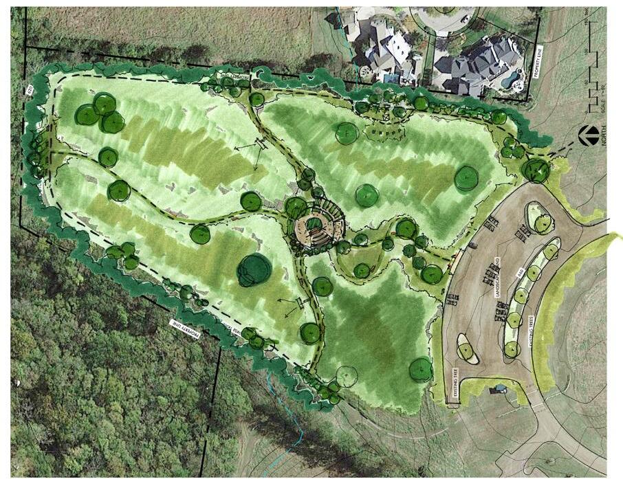
10 2030 SCALE: 1”=10’ CONCEPTUAL SITE PLAN MOUNTAIN TOP RETREAT
0’
This section, Other Works, showcases the breadth of my skills beyond standard project design. Here, you will find detailed renderings, precise grading plans, and technical details that illustrate my commitment to excellence and precision in landscape architecture. These elements demonstrate my proficiency in the technical aspects of design, my ability to visualize and communicate complex ideas, and my dedication to crafting landscapes that are both beautiful and technically sound.
04
OTHER WORKS PROFESSIONAL WORKS -
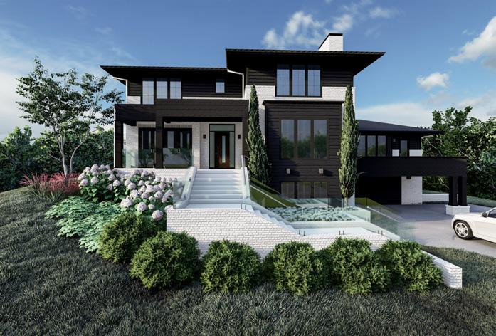
Residential Plan Rendering for Market Use
Commercial Project Plan Rendering
Sheet Name Project Number: Issue Date: 04/01/22 HOLLYWOOD 18 GRAPHIC ILLUSTRATIVE 5005 MERIDIAN BLVD. 615.719.1943 DISCLAIMER: The drawing conceptual and and illustrative drawing can be revised at prior notification not be relied representation project. GRAPHIC PLAZA ENLARGEMENT MARKET HALL BUIILDIING A BUIILDIING B ENTRY BAND SHELL THE PARK AT HARLINSDALE FARM NATURE PRESERVE FRANKLIN, WILLIAMSON COUNTY, TENNESSEE SITE CONCEPT OVERALL AERIAL PARKING LOT NEARBY NEIGHBORHOOD TRAIL HEAD MARKER INTERPRETIVE PANEL SITE 100’ 150‘ OTHER DRAWINGS
Conceptual Sketch for Prairie Landscape Design
3D Model Rendering for Residential Development

STUDENT WORKS -
Envision 2040 at U of I-Urbana-Champaign
Collaboration for Holistic Sustainable Solutions Champaign, Illinois, US.
Studio- Group work (Leader) / Individual work
University and neighbor cities, as a community with same destiny,through complementary and collaboration, to achieve sustainable co-development and co-prosperity.
01
2021 ILASLA Student Merit Award
Climate Change
Carbon Emissions
Water Resource


 Champaign
University of Illinois
Champaign
University of Illinois
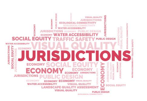
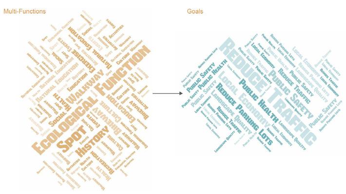
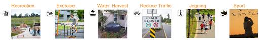
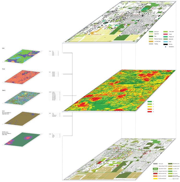
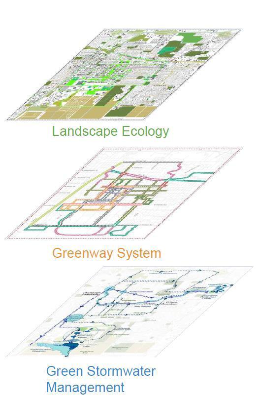
Reduce motor vehicle utilization Improvement of tree canopy Save precious rainwater resources Improve water visibility for education Stormwater purification and reutilization Create recreational water features Replenishment of groundwater resources Mitigate the urban heat island effect Improve Ecosystem service value Enhance Landscape Connectivity Urban runoff reduction Reduce carbon emission Improve street safety Provide urban green space Enhance streetscape quality Tree Canopy Green Parkings Urban green space Green Traffic Pedestrian Friendly Campus Stormwater Purification Clean Water Recycle Save rainwater resources Transportation system Background 1 2
Urbana
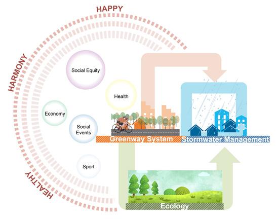
This project is trying to create a pedestrian-friendly transport system in order to reduce the number of parking lots and increase the safety level of transportation, which will help to reduce carbon emissions. It will explore trade-offs between three key elements: safety, usability, and aesthetics. It will propose a suitable balance between these elements by developing a framework for reshaping the existing infrastructure.

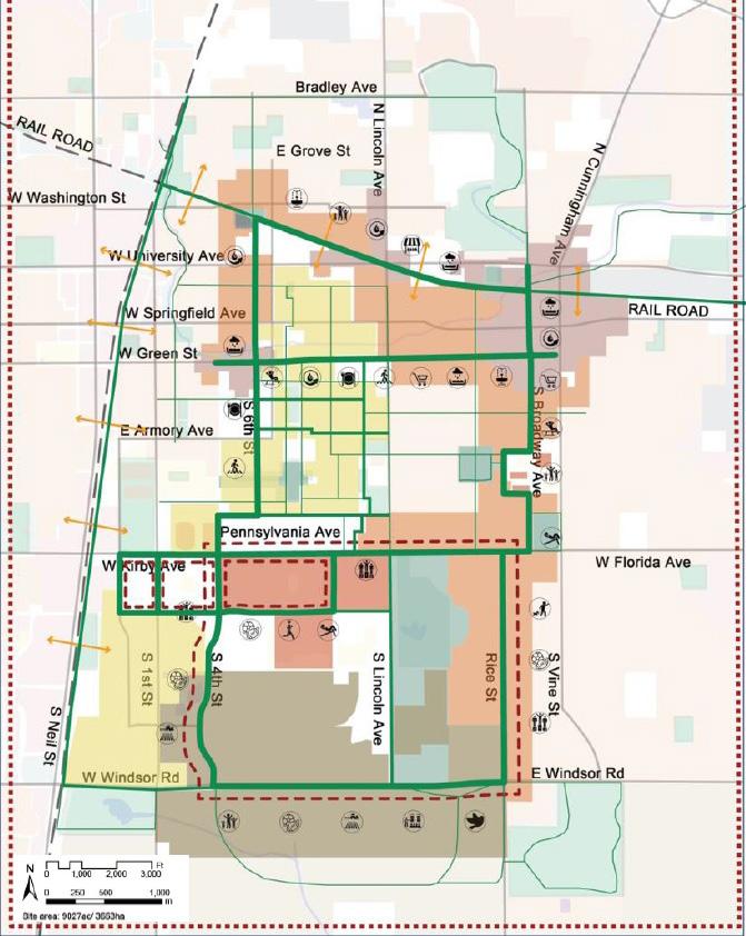
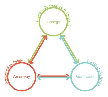
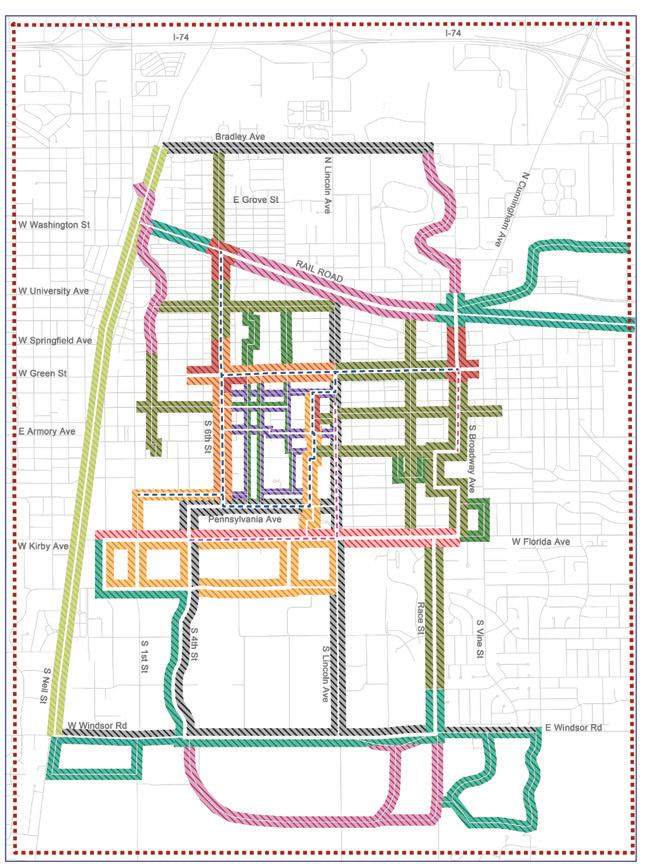
Greenway System
Multi-Functional
North Railway Low utilization rate
Commercial Opportunities
Apartments & Facilities
Abundant green spaces
Service facilities
Green Street
Sixth Street
Florida Avenue
Broadway Avenue
3 4

Research Walk Sport
Commercial
Trolley
5 6
Shared-Street Ecology-Landscape
Existing Green Network
Environment Sensitivity
This project aims to increase biodiversity, restore the ecology value and achieve urban rehabilitation. In order to help promote the economy, recall the culture and improve the environmental quality to meet the nationwide goals of alleviating global warming, rebuilding infrastructure, and reducing carbon emissions.
Ecology-Landscape System
7 8
Proposed Green Space
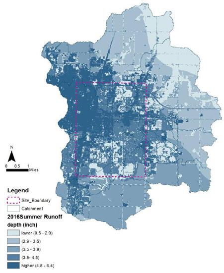
Depth Analysis
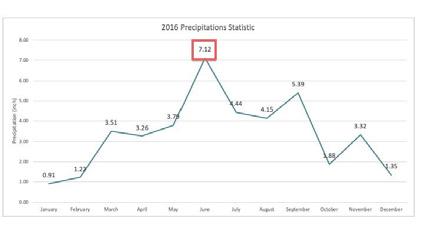
Precipitation Statistics
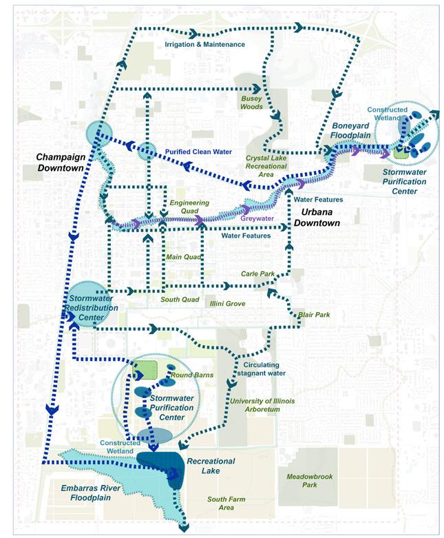
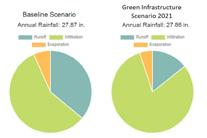
In the past, the designers have already successfully made the flood water drain out by using advanced technology and construction. But this project is pursuing a more challenging goal – stormwater harvest, recycle and reuse. The project tends to use stormwater to improve the environment quality, promote the ecologic value and increase the visual quality.
Monthly
Strategy Stormwater Management System 9 10
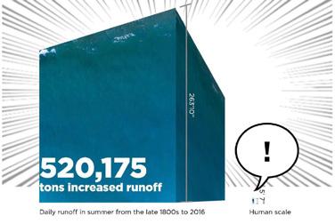
Daily Runoff Analysis
Runoff
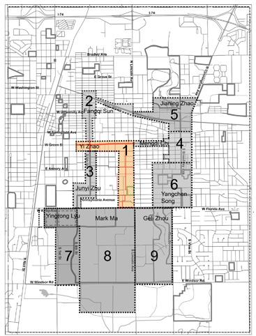

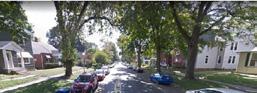
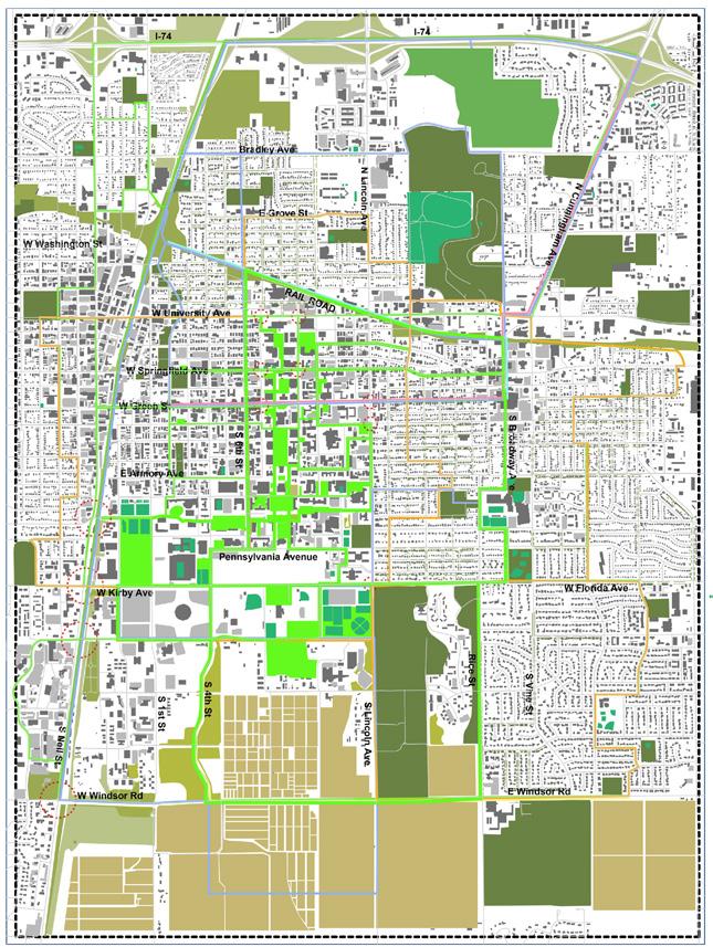
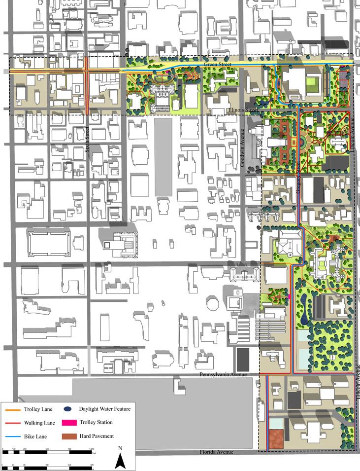
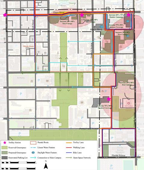
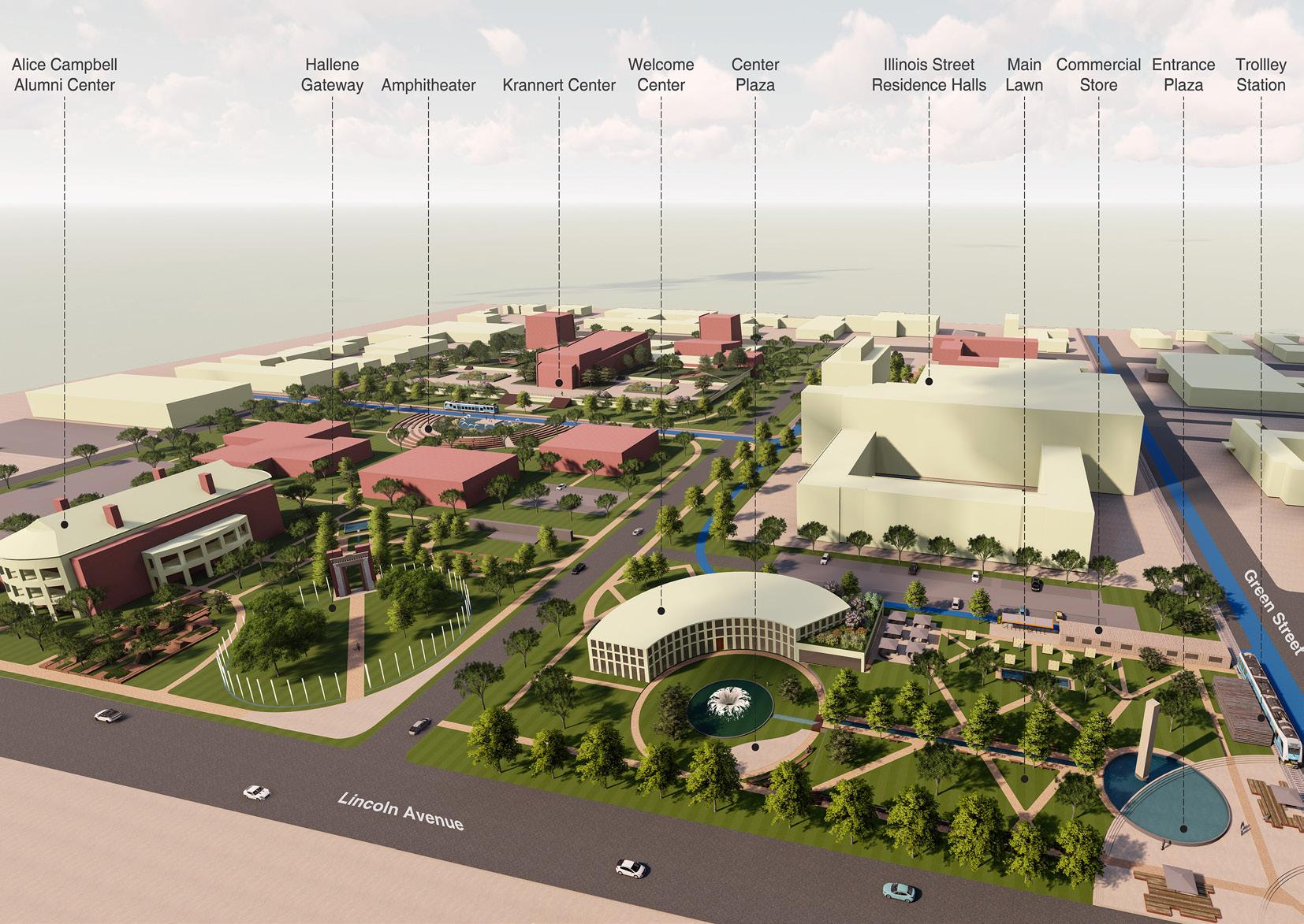
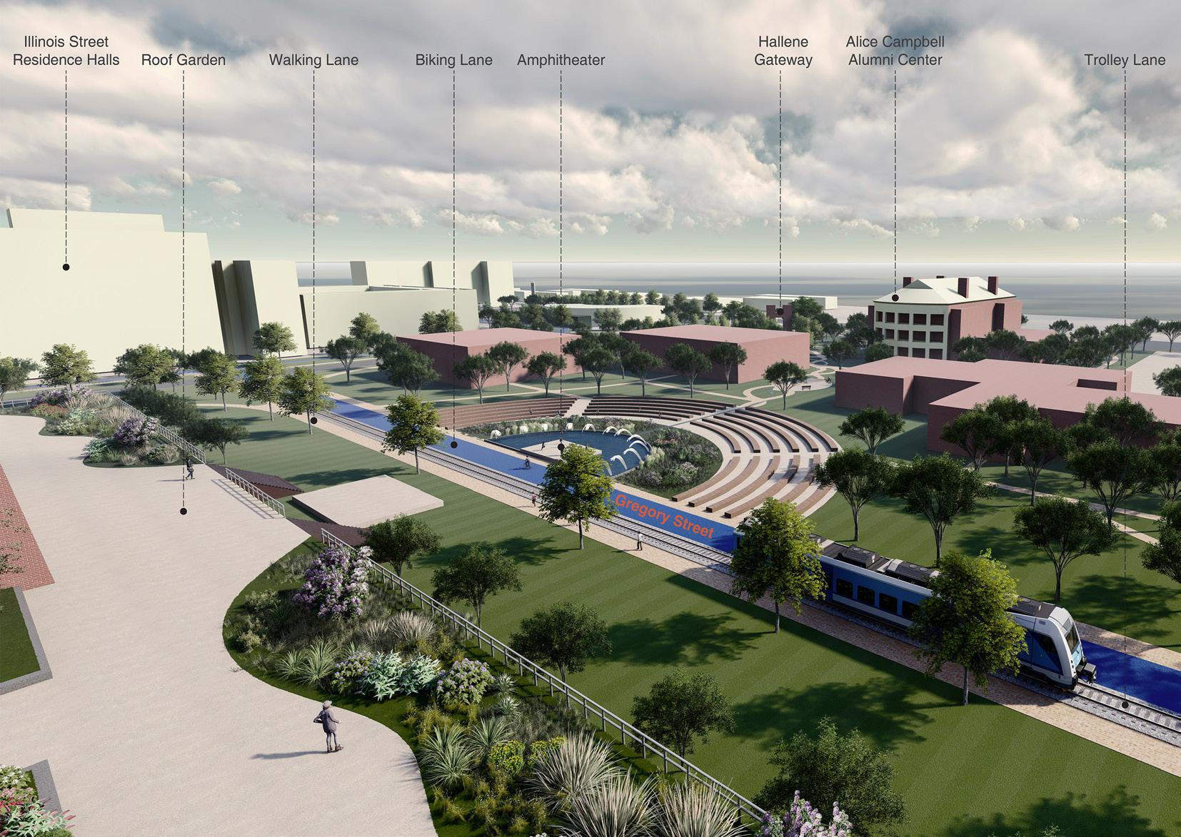
The site is located along the Green Street and Gregory Street, where has a lot of available space to design for various activities. And these two streets themselves have different characteristics. For the Green Street, there are more commercial facilities along it and there is more space on the street for people. Combing with the greenway planning system we did in the previous modules, we are tent to transfer Green Street into a Leisure greenway. And for Gregory Street. It connects one of the gateways of UIUC and surrounded by a lot of student dorms. Also it joins the Sport Loop with the Doner Drive and the Maryland Drive to the south. Based on the previous greenway planning system, we will transfer this street into a Sport greenway.
11 12

13 14
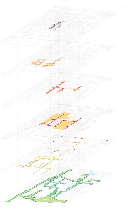
Urban Design Sturctural Diagram
Urban Design Master Plan Sketch
Urban Design Master Plan
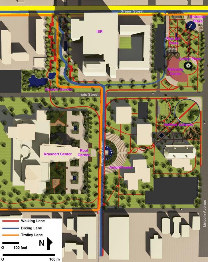
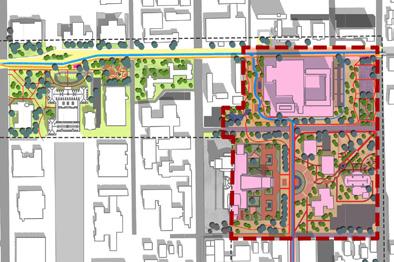
Site Design Location Site Design Master Plan 15 16
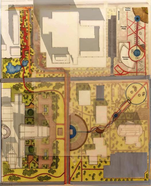
Site Design Sketch
17 18
STUDENT WORKS2019 National ASLA Student Honor Award
27 28

29 30
31 32
33 34
35 36
Research 37 38
39 40
41 42

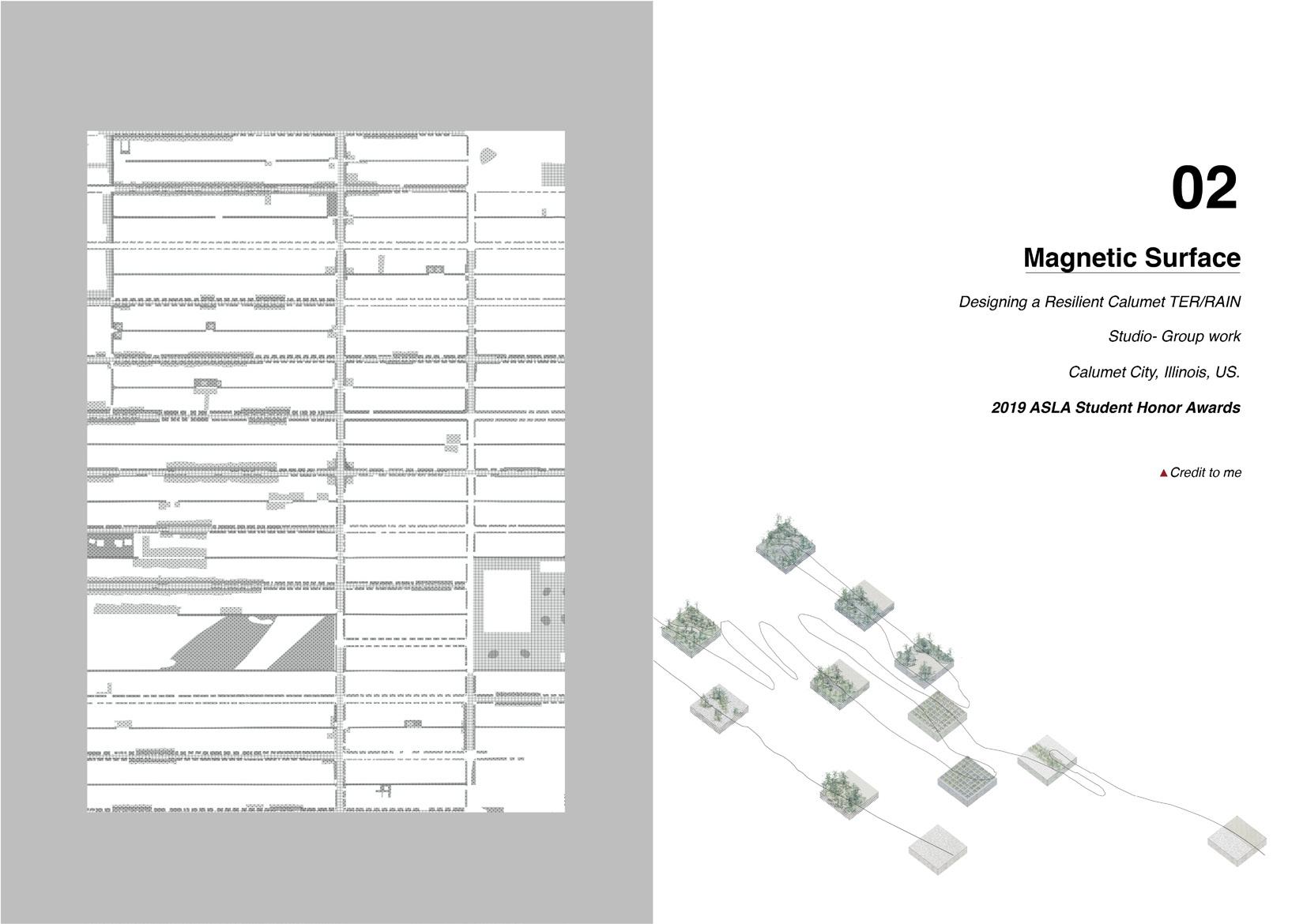
Exploring Demographic Vulnerability in the Context of Flood

GEO Design
Studio- Group work (Leader)
03
McHenry City, Illinois
STUDENT WORKS -
Regional Scale
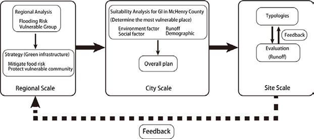
At the beginning, we start without predetermined goal: we examine the distribution of vulnerable people with flooding area to determine the area suffering most. In this area, we prove old people is the most vulnerable group comparing to other vulnerable groups. In this case, we consider how changes in the future will influence those old people and come up with two strategies: one is compact city, and another is greener city. Finally, we validate those two strategies and determine the most feasible strategy and scale it down into site scale.
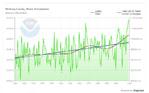
Precitipation Tendency
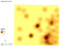
McHenry County Vulnerability Analysis Over 65 PopulationChange Rate Under 14 Population Change Rate
Why are older people more vulnerable?
•normal effects of aging
•limited mobility
•more likely to have chronic disease and disability
•communication (seeing, hearing or speaking)
•mental functioning (Alzheimer’s, senility, dementia)
•physical functioning (difficulty walking, climbing stairs, lifting or grasping objects)
•financial insecurity
•social isolation and marginalization
•strong attachment to place
•less comfortable with digital information
What are the impacts on older people?
•disruption to medical care
•lack of access to food stores, pharmacies
•lack of access by emergency services
•separation from familiar social structures
•exposure to contaminated water
•lasting effects of trauma
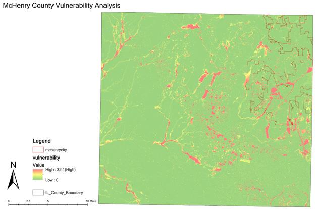


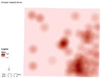
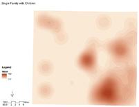
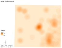
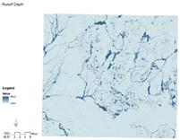
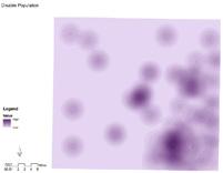
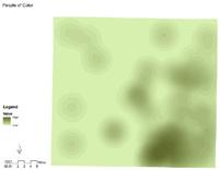
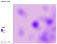
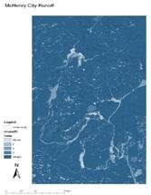
Based on literature reviews, we determined several criteria to analysis the vulnerability within McHenry County. The criteria is: single family with children, disability, population over 65 years old, renter occupied home, people of color, female headed home, runoff depth and low income home. We give them equal weight to get the final result. And based on this result, we decided to narrow down the scale into McHenry City.
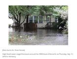
Flood in 2019
91 92 Flood
Timeline
From 2000 to 2010, McHenry County has a relatively high negative growth in population of under 14 years old, compares to other counties in Illinois.
From 2000 to 2010, McHenry County has a relatively high possitive growth in population of over 65 years old, compares to other counties in Illinois.
Background
Reducing risk of fooding will benifit everyone, and especifically for older peeople because floods will be more likely to:
Cut them off from stores, library
Cut off access by ambulances if they need them
Cause significant financial harm
Require them to do the difficult physical work of evacuating, placing sandbags or moving all their stuff to higher ground


City Scale
Potential Migration Site
Migrate older people to suitable places will make them have a more convenient environment and less likely to be impacted by floods.
Key features of suitable locations for older people include:
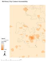
Accessibility to grocery stores, pharmacies, medical centers and cultural resources
Walkability
Low possibility of flood
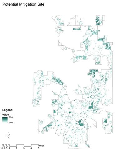
Mitigration Site

* * *
* * * *
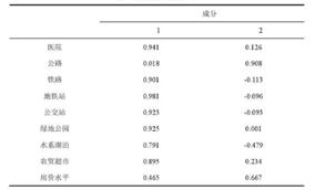
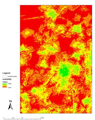
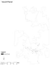
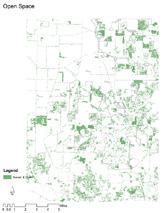
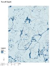
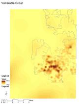
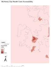
Criteria Criteria Vacant Parcel Slope Open Space Runoff Depth Runoff Depth Health Care Accessibility Volunerable Group Potential
Cultural Center Accessibility 93 94 28 % 22 % 28 % 22 % 28 % 28 % 16 % 28 %
Potential Mitigation Site
Mitigation Site
Potential
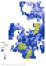
For strategy I – Potential Mitigation Site, we use four criteria to filter the whole site to choose the mitigation site which has more potential to reduce the impact for vulnerable people. For strategy II – Potential Migration Site, we use four different criteria to choose the most suitable site for vulnerable people to live, avoiding the impact of flood. And make those places as potential sites for vulnerable people migrate to.
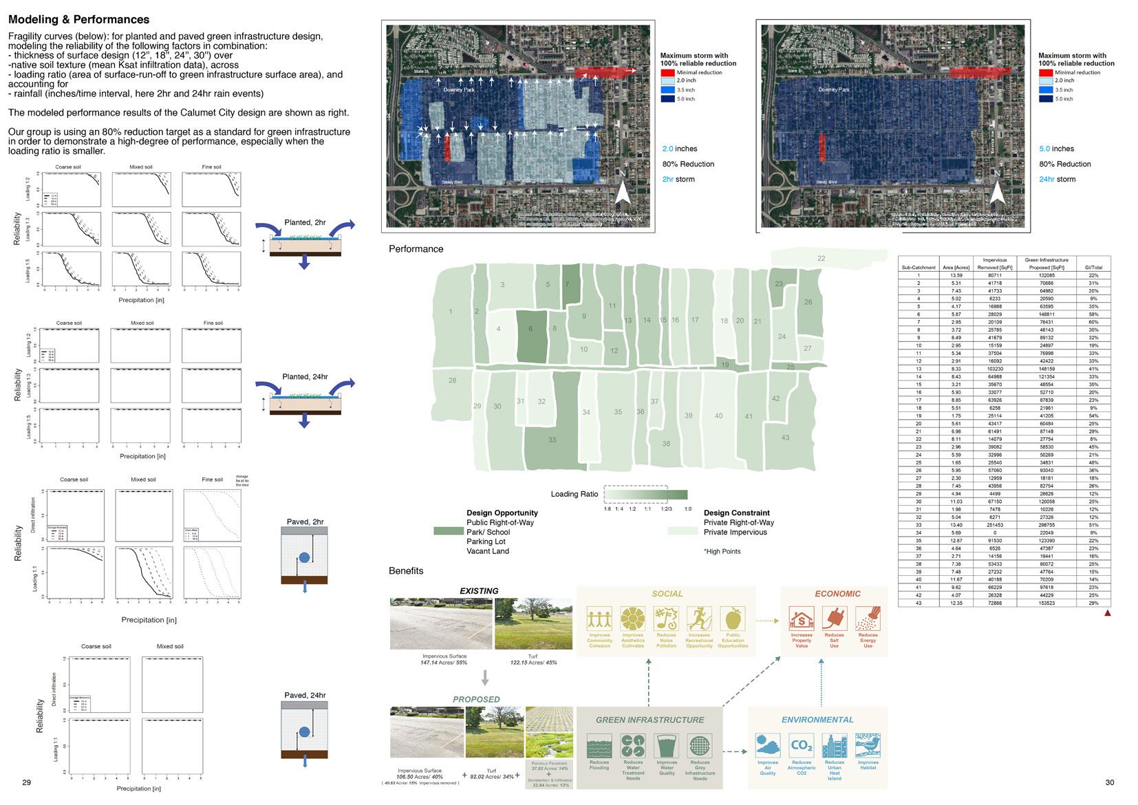
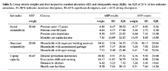
After we pick up three areas which have highest density of vulnerable people as research areas, we made a comparison among their mean runoff.
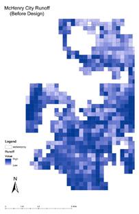
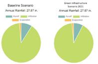
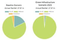
Comparing design strategy I and II with business as usual (no action), result shows that runoff depth in design strategy I decreases, but design strategy II’s runoff depth increases. In this case, design strategy I seems like a better idea. However, we also admit this validation has some limitations: first, we fail to condiser the effect of topography to runoff concentration; second, design strategy II concentrates more people in certain area, which results in higher percentage of urbanization. Without change of other factors, increasing urbanization definitely increases runoff.
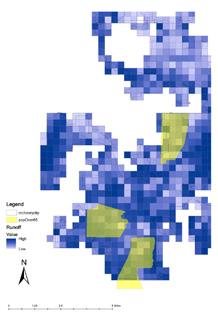
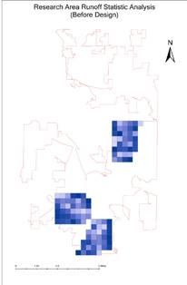
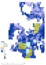
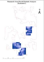
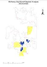
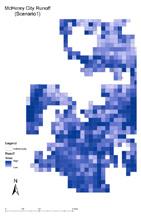
The result shows that this strategy does reduce the runoff in every research area.
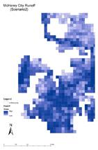
The result shows that this strategy reduces one of the research areas, but the runoff of the other two areas is increased due to the higher urbanization level.
1.73 inch 2.01 inch 1.52 inch
Land Cover 1.72 inch 1.98 inch 1.43 inch Strategy I Land Cover Land to be Changed 1.94 inch 1.60 inch 2.79 inch Strategy II Land Cover Land to be Changed 95 96
Validation
Current Condition
Site Scale
In this scale, we began by exploring the communities, landscapes and environmental quality of the county at a regional scale. We discovered that the area has lots of good things, including varied topography, relevant history, rich agricultural land, many parks and nature preserves, good air quality, public transportation connecting to Chicago and much more. We chose to focus at a local scale on the town of McHenry, specifically the area along Boone Creek, as our initial site for design interventions to change flooding patterns and to protect vulnerable communities living in this flood-prone area.
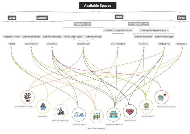
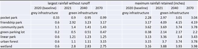
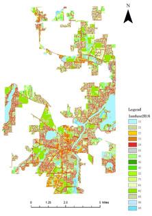
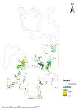
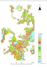
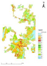
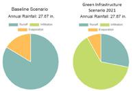
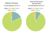
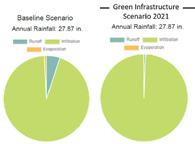
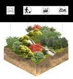
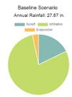
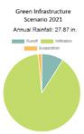
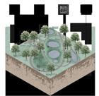
As there exists various available spaces in site and they are not well distributed. Our group decides to divide them into several types according to their common characteristics. Characteristics involve size and surrounding environment. Seven types of green infrastructures with their functions are listed at left.
97 98
Green Parking Lot
Urban Forest
Friendship Park
Community Park
Linear Space
(>25 ha) (12 - 25 ha) (<12 ha)
Pocket Park
Wetland
Validation for Typology
Typology