Regional planning West Bank As A Case Study - Palestine- Yanah Enayah
Regional planning
West Bank As A Case Study - Palestine
ENPL537
PRINCIPLES OF REGIONAL PLANNING
Dr. Salem Thawaba Eng. Maha Abu Maria
Yanah Enayah 1172103 | Dana Musaffer 1171203 | Alia Jamhour 1172470
Abstract
This paper examines regional planning in the northern region of the West Bank, Palestine, and analyze its components in order to come up with a new regional plan and suggest a new framework which solves the main issues in the the regional context. The article intends to gather and evaluate data on the site in order to provide a future vision for the whole area, which will encompass several variables. This vision will serve as the foundation for the suggested alternative. To define the proposed vision, the ultimateoutcomewillbeasuggestedconceptualcomprehensivemasterplanforaportionoftheareainthenortherndistrict.
Regional planning is the science of efficient placement of infrastructure and zoning for the sustainable growth of a region” (Krigul and Lepik, 2008). This paper focuses on regional planning,which will examine the features, concepts, and principles that regional planning aspires to. This study will be conducted in Palestine West Bank, which was chosenasacasestudy.Palestinehasvariousgatesfordifferent functions.
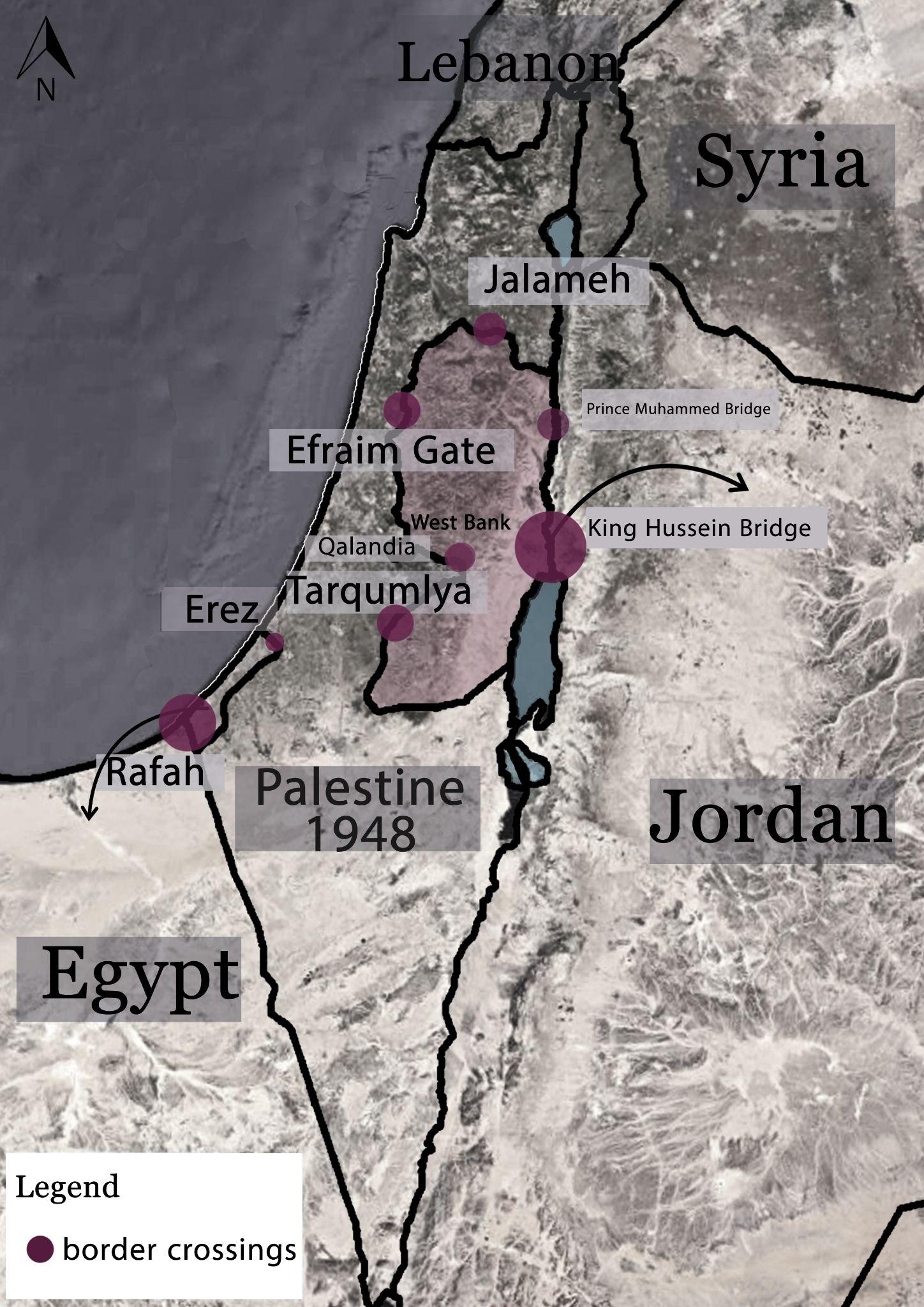
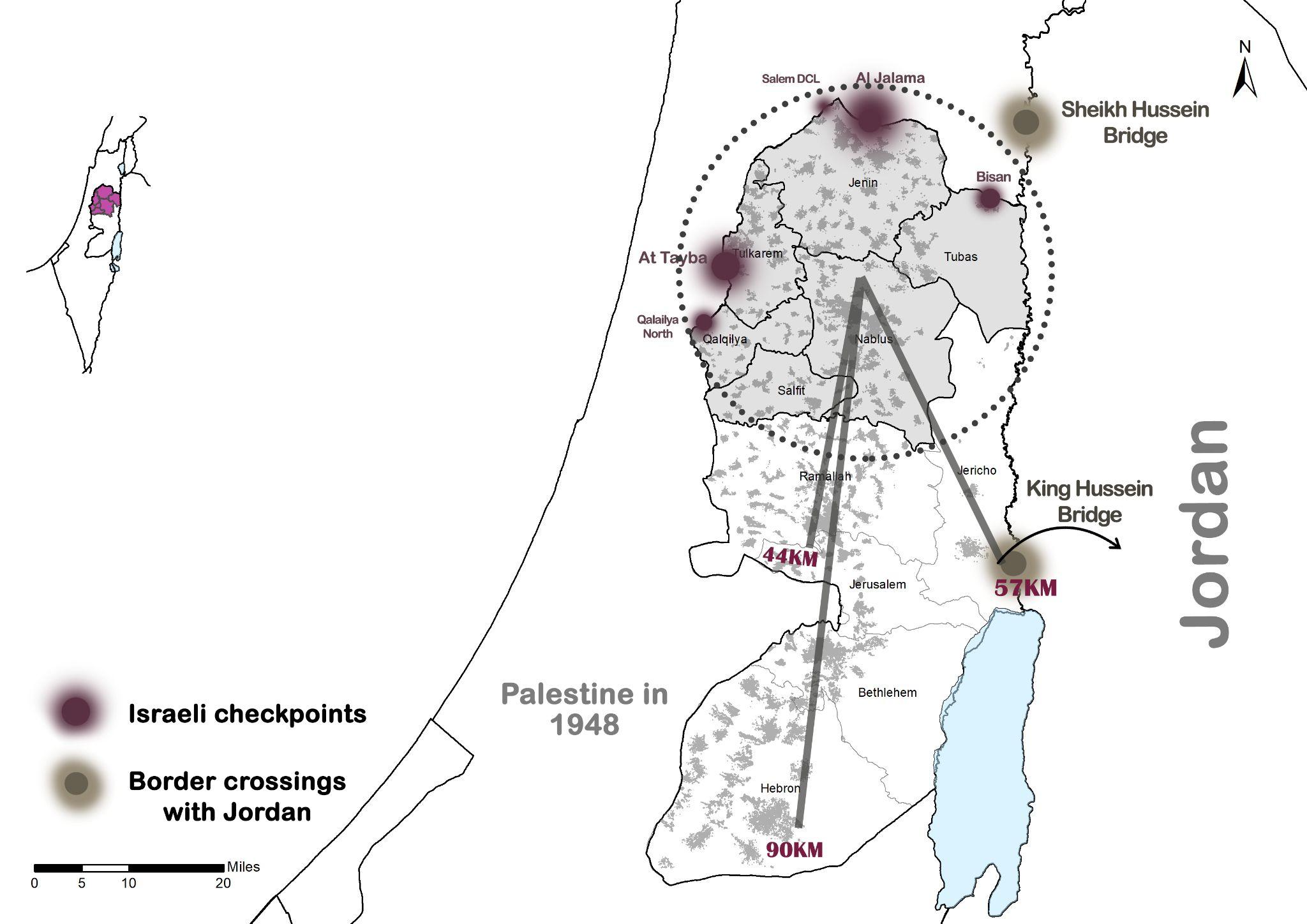
Palestinians from the west bank can travel out from palestine through the King Hussein Bridge. In Gaza palestinians travel through the Rafah gate , Prince Mohammed Bridge is used for commercial uses. In the west bank area we can notice that there is four paths to visit “1948 land” , Al-Jalameh gate, Qalandia gate , Tarqumiya gate and Efraim gate. These gates mostly creates a traffic congestion and obstruct the palestinian movment, see map (1) (WAFA, Palestinian News & Info Agency, 2020) .The State of Palestine has a total population of more than 4.5 million. The state consists of sixteen administrative divisions, of which the Hebron district ,The Gaza division . The state considers East Jerusalem to be its capital, although the city of Ramallah functions as its administrative center. The number of the Palestinian population at the end of 2020 residing in the State of Palestine is estimated at about 5.2 million, including3.1millionintheWestBank(59.8%),and2.1million(40.2%)intheGazaStrip.
Map (1): location and main border crossings
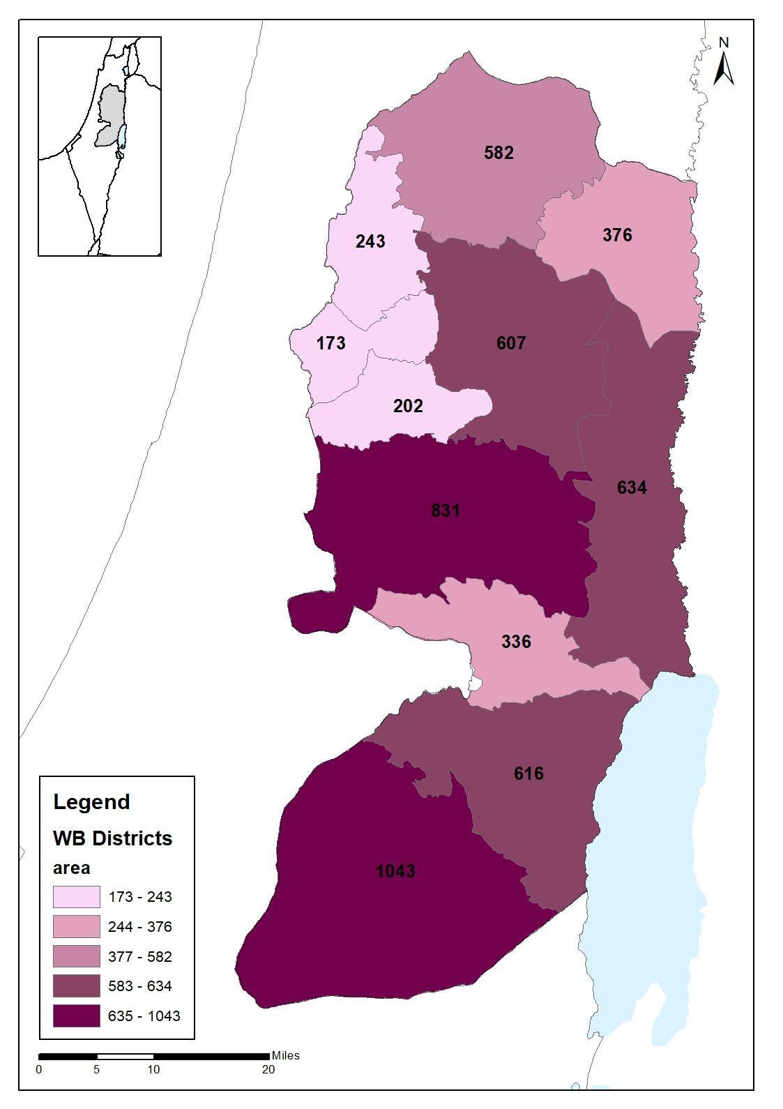
Governorate Areas
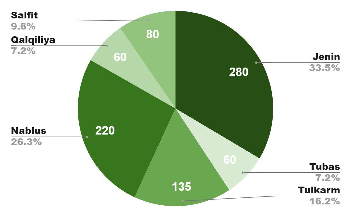
As shown in the map, the differences in the governorate areas is noticed. the largest Palestinian governorate in the West Bank is Hebron, and the smallest one is Qalqilya Governorate. Some cities form agglomerations with other towns or cities. Cities area affects the population and the growth. (Statistics from Geomolg, 2020))
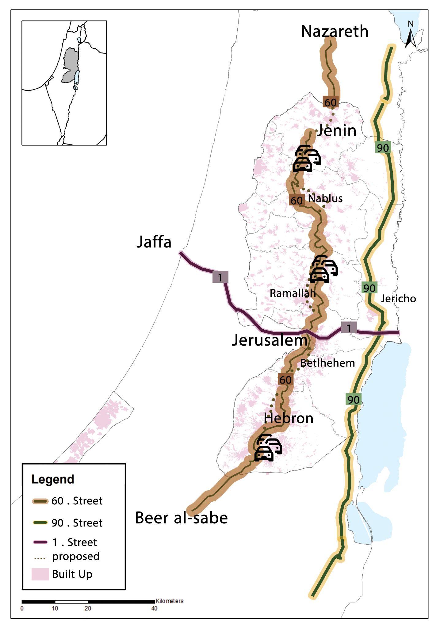
Regional Roads
Tow regional streets are existed in the West Bank. The 60 Street is a regional road that splits the West Bank vertically, starts from the north in Nazareth, ends at Ber Al-Sabe in the south. It passes through Hebron, Bethlehem, Jerusalem, Ramallah and Jenin. The road basically connects the settlements in the West Bank to each other. It is divided into two parts. (Statistics of the Ministry of Transport and Communications, 2020)
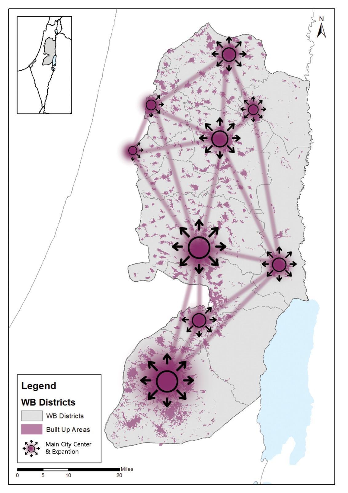
City Centers
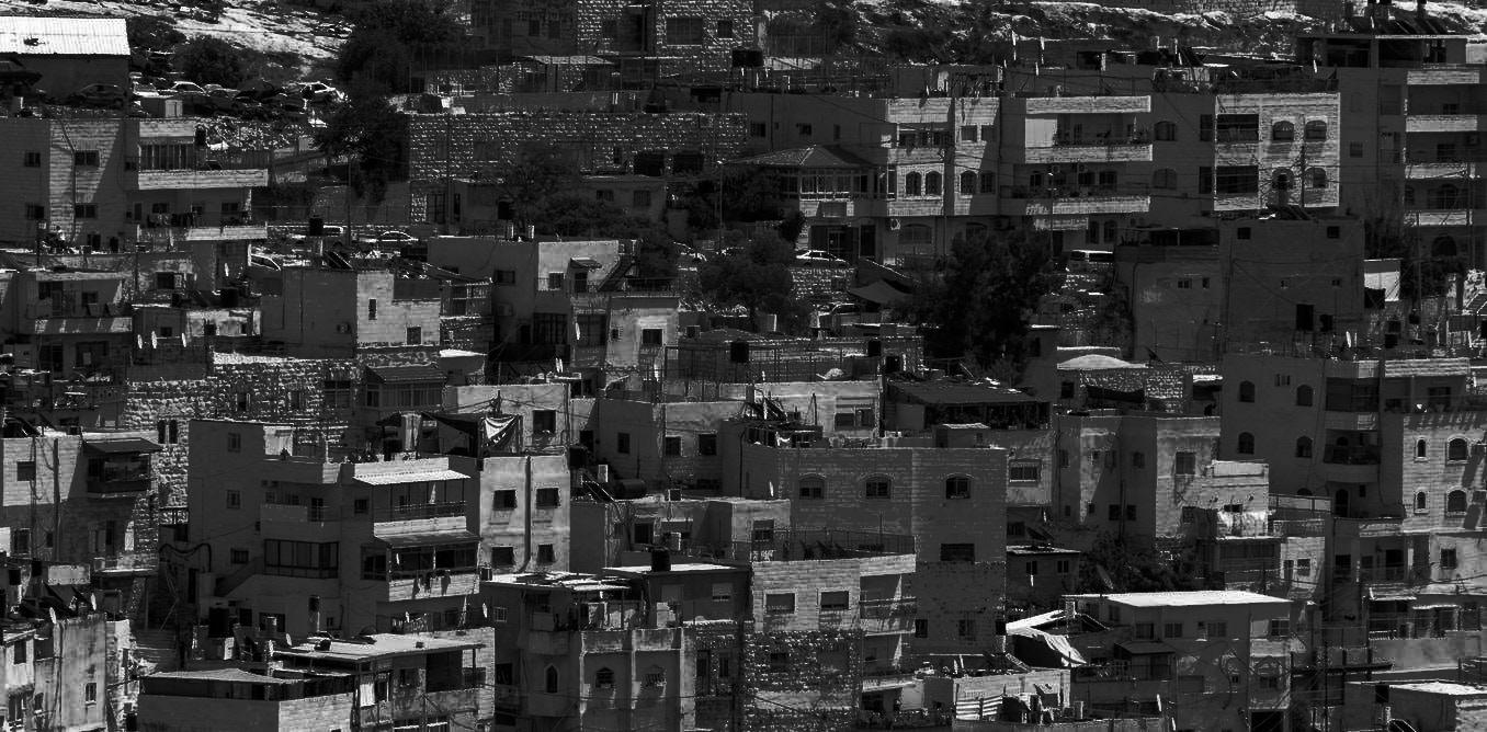
Many regional areas suffer from the absence of urban expansion management and direction, which leads to creating problems in the infrastructure and transportation sectors, in addition to the unbalanced distribution of services between urban and rural centers with the weak relationship between urban centers functionally and physically, and therein lies the need for a plan Cites expansion is limited by mainly israeli settlements and the aparthied wall as we can an example in Qalqilya which is surroundedbythewallfrom3sides. (WAFA, Palestinian News & Info Agency, 2020)
Map (2): Governorate area
Source Geomolg,2021, Edited by the students
Map (3): Regional Roads
Source : Geomolg,2021, Edited by the students
Map (4): The city Center & its interconnectedness
Source : Geomolg,2021, Edited by the students
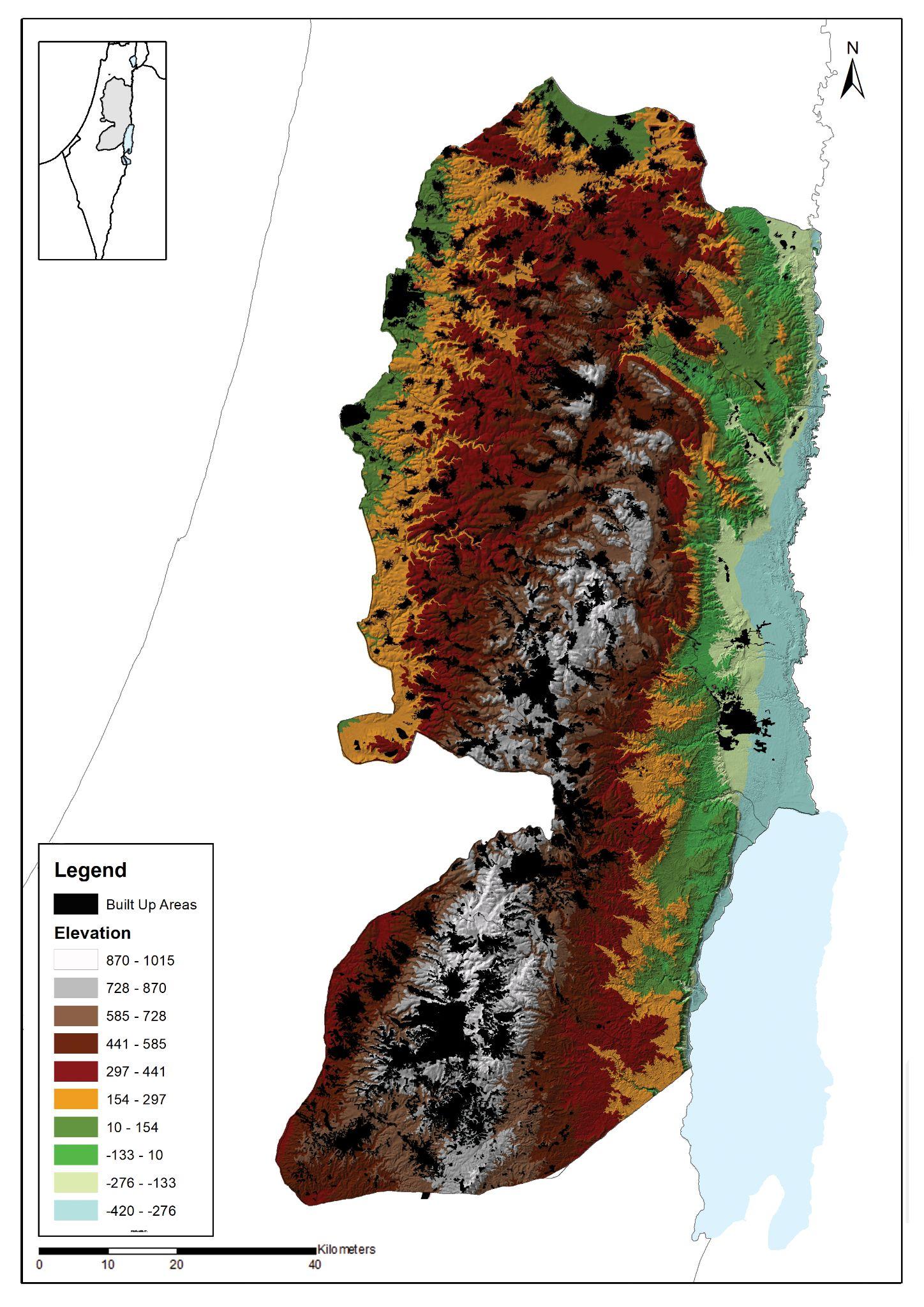
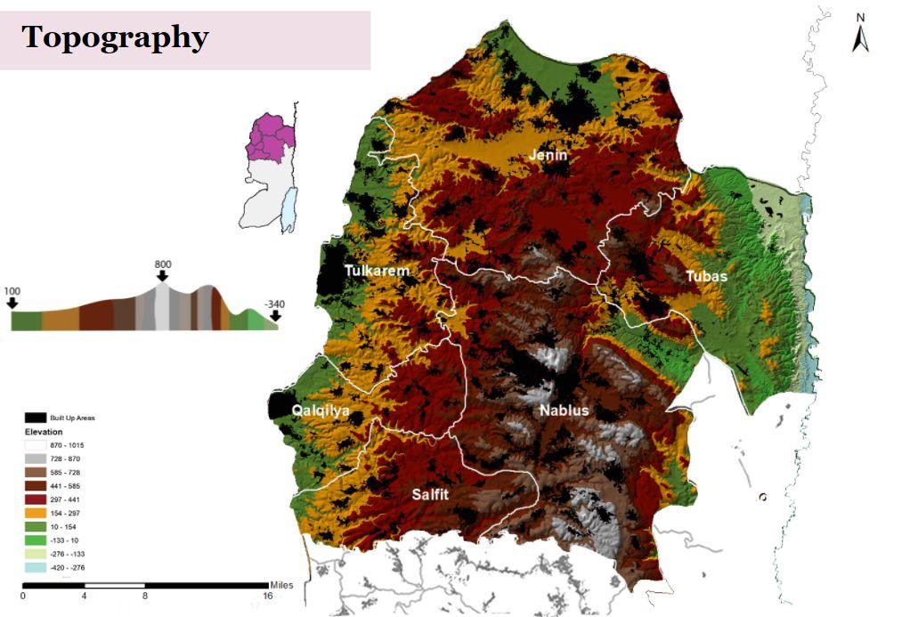
Palestine Geography consists of four regions in the country. The four regions of Palestine Geography are Jordan valley and Ghawr, coastal and inner plains, Mountain and Hills and Southern Desert. The coastal plains of Palestine are divided by Saruunah plain, Mount Carmel plain and the Acre plain. The population density is concentrated on the central areas of the West Bank, which are characterized by their mountainous terrain, as shown in the map(5). (WAFA, Palestinian News & Info Agency, 2020)
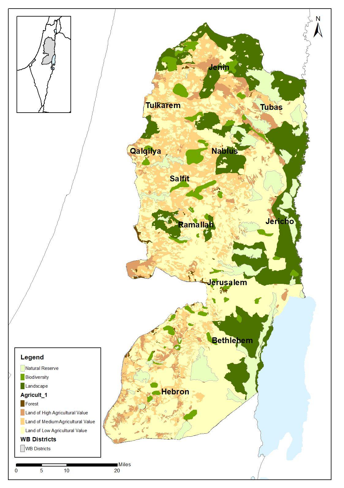
The agricultural sector
The agricultural sector is developing rapidly and is working on the export of many products such as medicinal plants, in addition to citrus fruits, olives, tomatoes, spices and fruits. Urban expansion at the expense of agricultural land is a serious problem in the occupied Palestinian territories. It is noted that the governorates of Nablus and Jenin have concentrated vegetable cultivation; while the cultivation of fruit trees was concentrated in the governorates of JerusalemandNablus. (WAFA, Palestinian News & Info Agency, 2020).
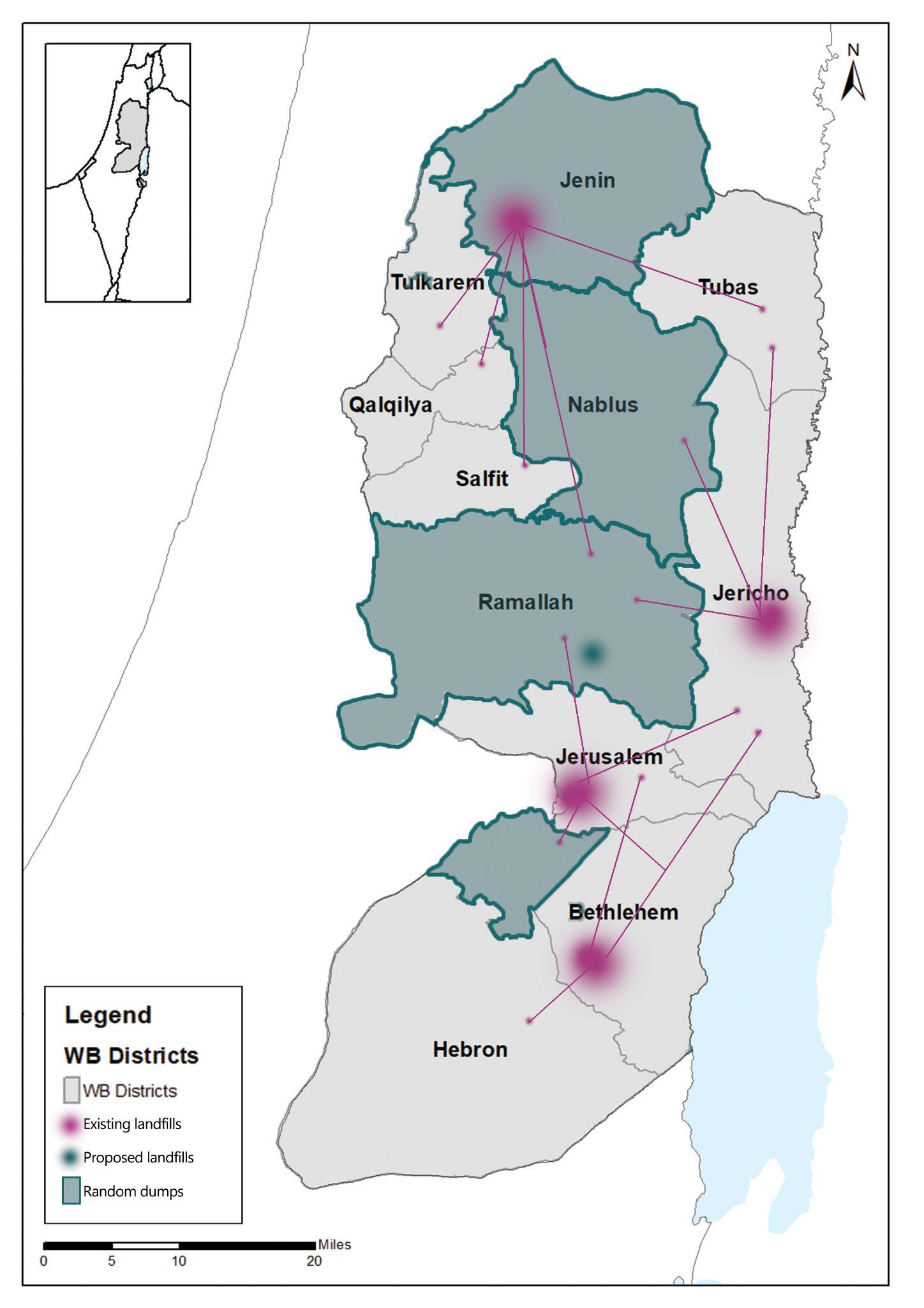
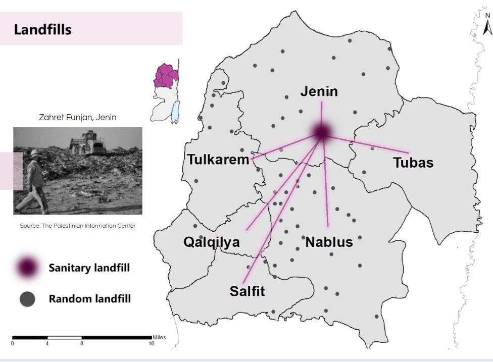
There are 4 existing landfills counted as Zahret al-Finjan landfill in Jenin , the Mina landfill in Bethlehem, and the Jerusalem landfill were operated. Plus another landfill in Jericho, while the proposed landfills are in Ramallah Governorate (such as the Ramon landfill. Ramallah , Qalqilya and Salfit lack sanitary landfills and depend on random landfills to dispose of waste, in addition to the presence of transfer stations to facilitate and organize waste management for health landfills. (WAFA, Palestinian News & Info Agency,
2020)
Map (5): Topography
Source : Geomolg,2021, Edited by the students
Map (6): Agricultural Lands
Source : Geomolg,2021, Edited by the students
Map (7): Existing Landfills
Source Geomolg,2021, Edited by the students
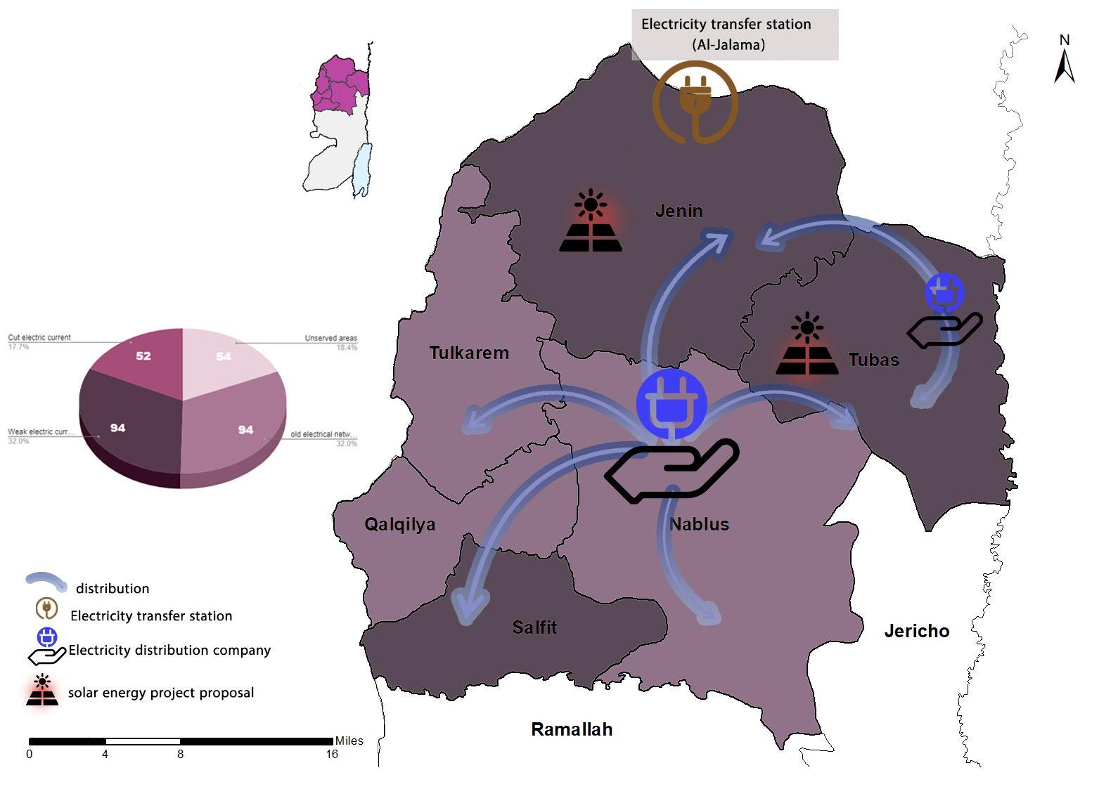
Energy and electricity Unemployment
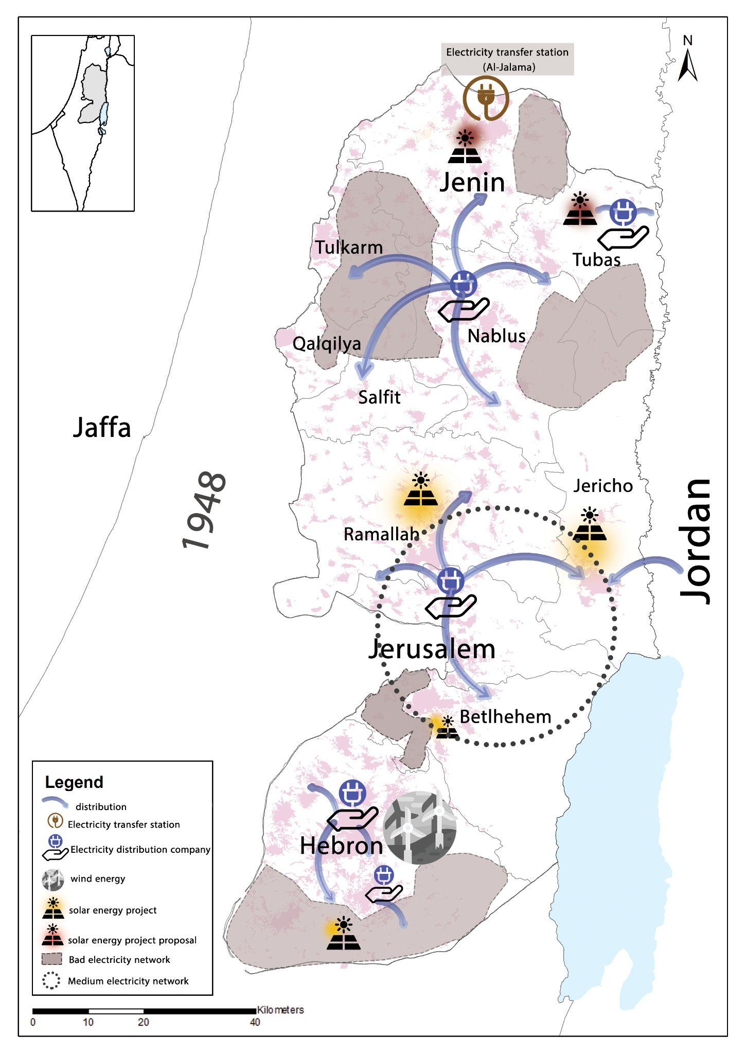
The West Bank is supplied with electricity by the Israel Electricity Company through 237 interconnection points. This system leads to a high rate of technical losses and electrical interruptions frequent, and the lack of capacity in many areas. The managed system currently distributionintheWestBankbyfivedistribution companies are the Electricity Company of Jerusalem, JDECO province) and feed the central WestBankareas. (WAFA, Palestinian News & Info Agency, 2020)
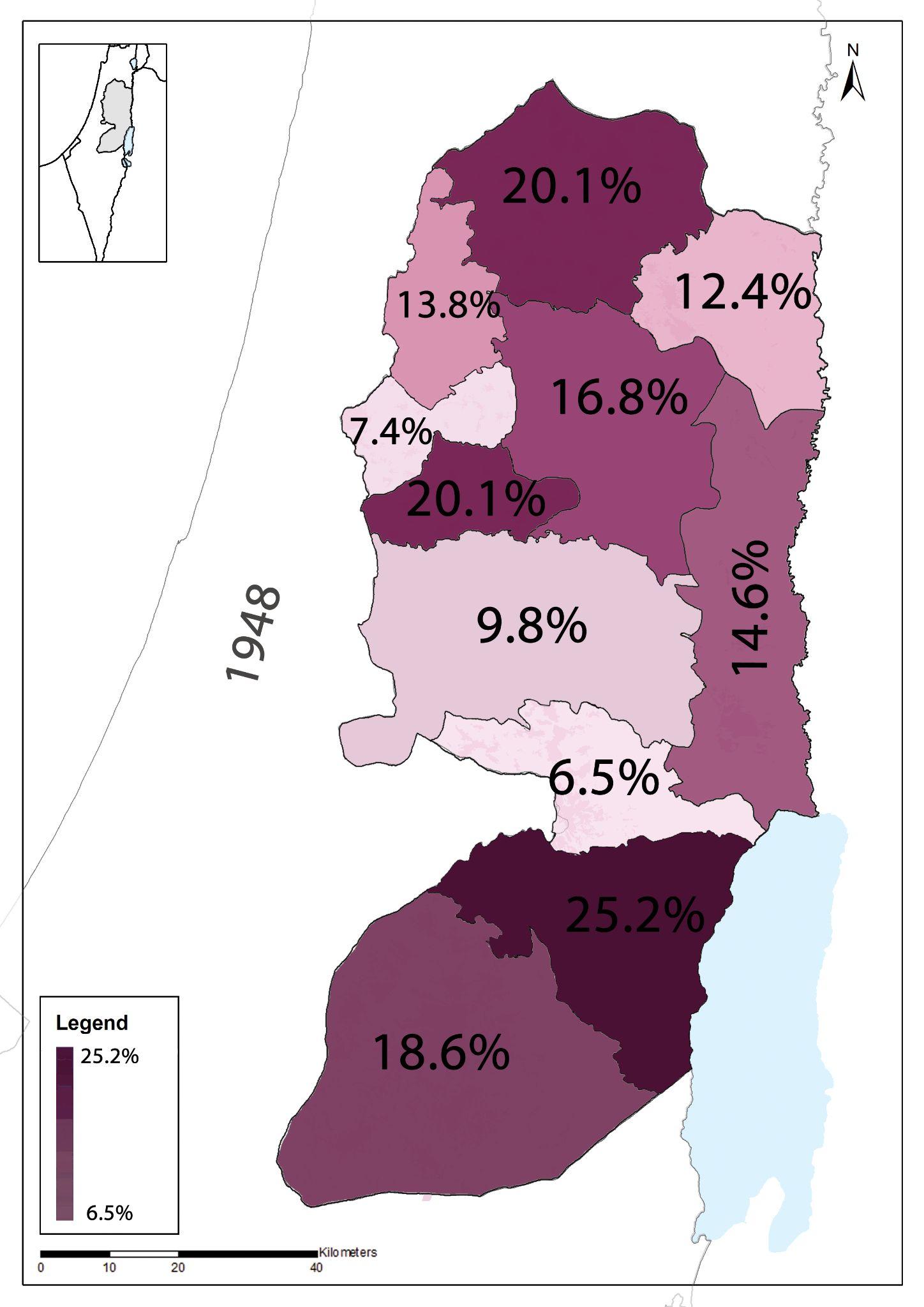
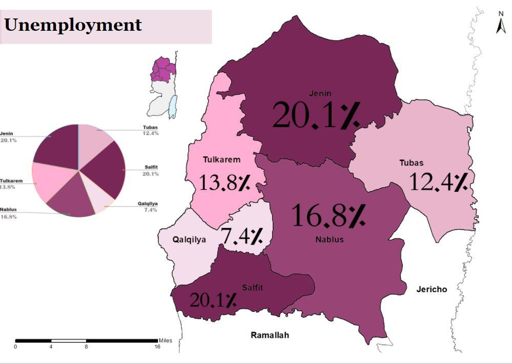
Unemployment levels has been clearly increasing after the pandemic. The unemployment rates are the highest mainly in the southern governorates. As shown in the map () Jerusalem governorate has the lowest rates , It’s noticed in Ramallah and Al-Bireh governorate how the unemployment rates are low, this is because it is considered an administrative capital and the presence of ministries in Ramallah and Al-Bireh governorate contributed to the availability of job opportunities there and the influx of Palestinians to work there from the variousgovernorates. (Palestinian Central Bureau of Statistics, 2020)
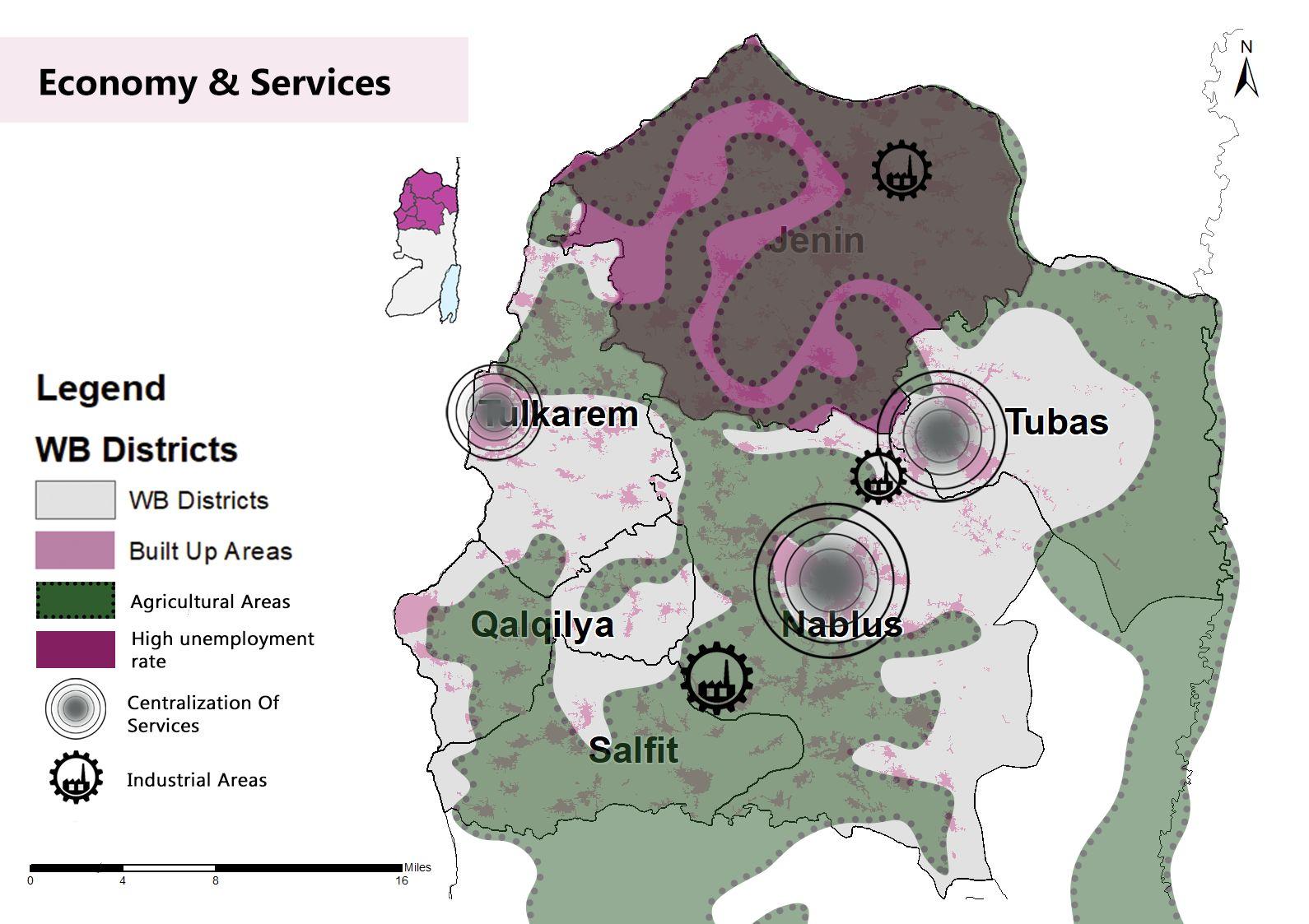
Economy and Services
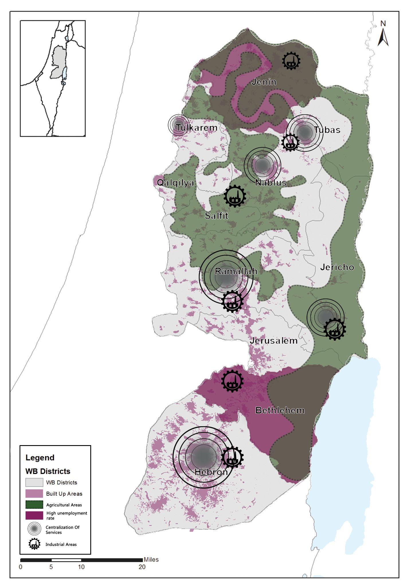
One of the most important components is the high-value agricultural areas located in the northern West Bank and northern Hebron, which constitute an opportunity to form a food basket. There are also areas that has the opportunity to form industrial areas or strengthen existing areas, such as Al-Jalama area. The urban centers were characterized by a high level of education, health and other services, the presence of high employment rates in Tubas, Bethlehem, Nablus, Qalqilya and Hebron. The presence of industrial cities in several governorates, namely: Jenin, Jericho, Ramallah and Al-Bireh, BethlehemandHebron. (Palestinian Central Bureau of Statistics, 2020).
Map (8): Energy & Electricity
Source : Geomolg,2021, Edited by the students
Map (9): Unemployment
Source : Pcbs,2021, Edited by the students
Map (10): Economy & Services
Source : Pcbs,2021, Edited by the students
Literature Review
The term ‘regional planning’ consists of the spatial entity of ‘region’ and the practice of ‘planning.’ The notion of a ‘region’ varies widely in different contexts and encompassesawholevarietyofregions. HarveyPerloff(1968)pointedoutthatregionalplanninghaddevelopedalongpragmaticlineswithrelativelylittleattention toformaltheoryanddefineditasthe‘ordering’ofactivitiesandfacilitiesinspaceatascalegreaterthanasinglecommunityandlessthananation,or,inthecaseof acommonmarketsituationwhereanumberofnationsareeconomicallyintegrated,lessthanthatofintegratedtotality.(Perloff,1968)
Comprehensive regional plans have also been devised for polynucleated urban areas and for open regions such as river basins. Because, for historical reasons, regions often lack governmental organization congruent with their natural or economic characteristics, the realization of regional planning goals, policies, and projects has often been constrained or limited. Nevertheless, significant instances of the successful implementation of regional plans or elements of plans can be cited.(Johnson,2015)
Greater London, Paris, New York, and Chicago, for example, all have benefited from past efforts at regional planning. In an increasingly interdependent world faced with environmental degradation, economic development needs, and social inequities, there is a growing awareness of the need for effective regional planning in the form of integrated regional resource management. But pervasive fragmentation of political jurisdictions, dominance of short-term over long-term decision-making, growing inequities between economic classes, and the frequent absence of consensus on goals or future visions still present formidable obstacles to the realization of regional planning in both developed and developing nations. Powerful new tools for data management and monitoring, such as geographic information systems and computer-based visioning simulation, promise to be of considerable help in overcoming barriers to effective regional planning. However, these tools are no substituteforimaginativeplanning,politicalwill,andabroadagreementonwhatfutureregionscanandshouldbecome.(Johnson,2015)
The main purpose of urban and regional planning is to pursue the interests of the community as a whole. However, with the increasingly diverse social and multiculturalstructureofourcontemporaryurbansocieties,thatpurposeisnolongerasstraightforwardasitmayhaveappearedinthepast,sincecitizenswithsuch highlydifferentsocialandculturalbackgroundshavepotentiallydifferentandconflictinggoals.Inpartforthisreason,urbanandregionalplanningisnolongerseen as a politically neutral activity, contrary to the prevailing perspective during most of the twentieth century, namely within the framework of the rational planning paradigm. Planners and other professionals and officials in city government need to gain the confidence of the community they serve and for that reason he or she mustcommittoastandardofconductthatisfarhigherthanwhatisstrictlyrequiredbytheplanninglaw.(Silva,2015)
After determining the location of the site study, a literature review was done for a better understanding of the regional planning. After that, data is collected, evaluated and analyzed by using ArcMap GIS for the different sectors that play an essential role in the urban textile includes: infrastructure, communities population, economyandservices,geographyandlandscapes,andthechallengesthatarebeingstudied.Youwillfaceitandtheopportunitiesandpotentialsthatcanbeutilizedto achievethebestresultsformasterplan.SeeDiagram(1)
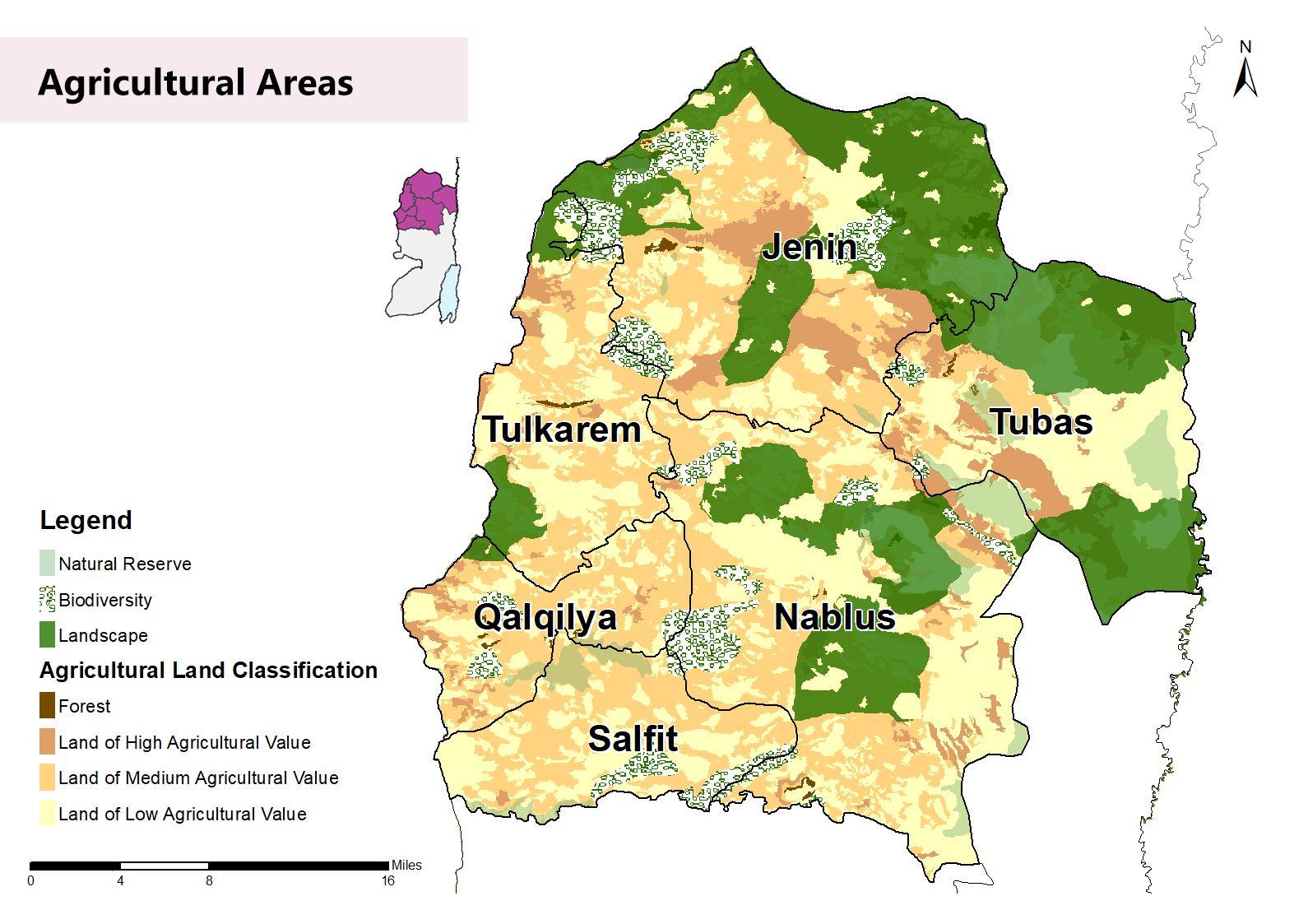
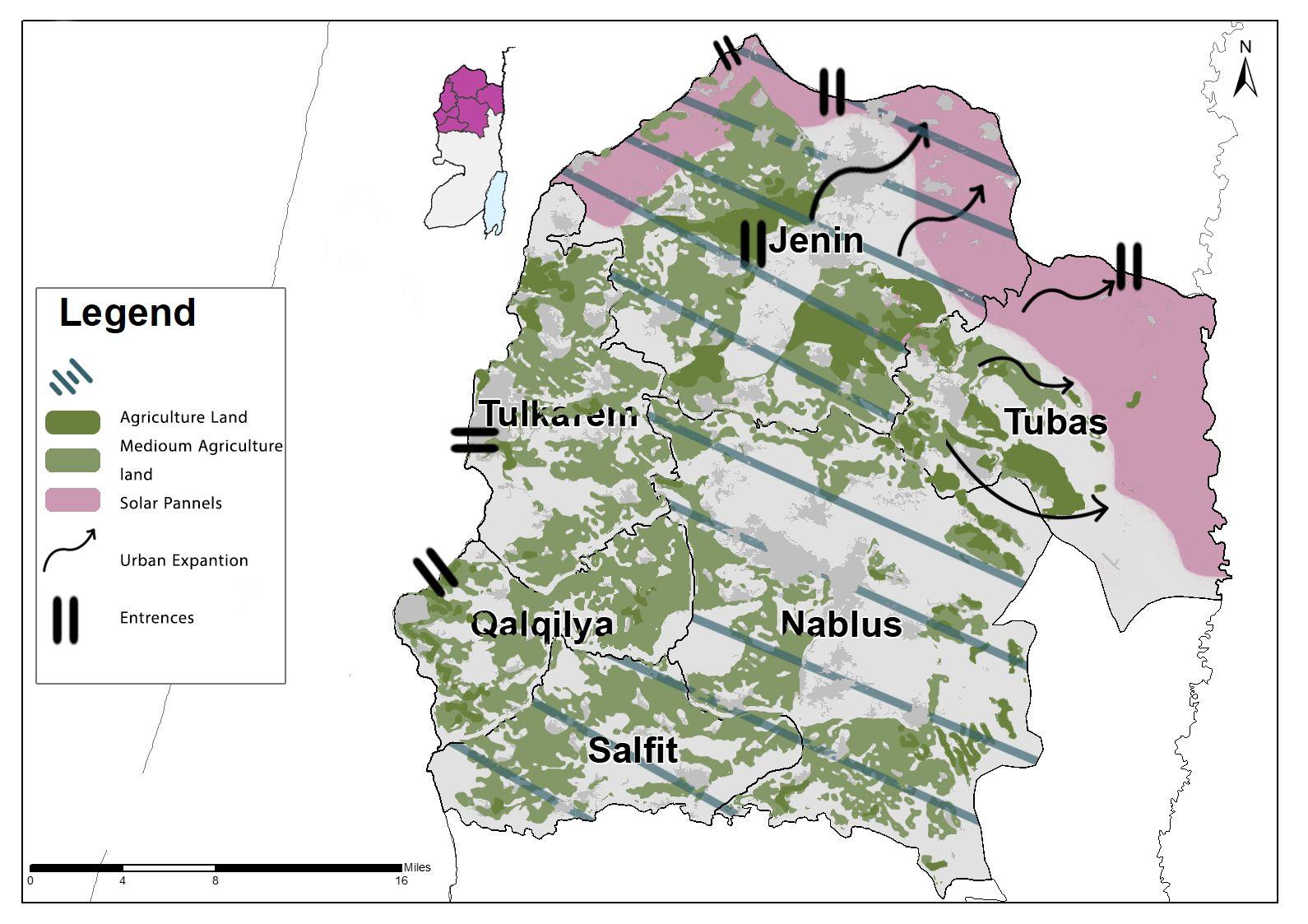
Agricultural lands are an important component to bedemonstratedandtakenintoconsideration,as they forms a large part of the study area with highandmediumvalue,seemap(13).
Northern governorates lacks of job opportunities in general, the highest unemployment was found in Jenin, Salfit and Nablus governorates, as showninmap(14).
Unemployment Rates
Map (11): Location and Surroundings
Source : Geomolg,2021, Edited by the students
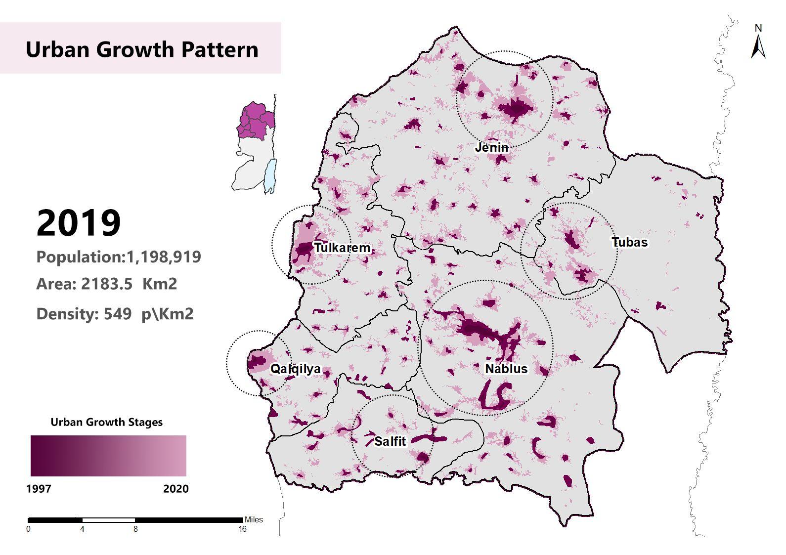
Map (12): Urban Growth Pattern Source : Geomolg,2021, Edited by the students
Map (13): Agricultural Lands Source : Geomolg,2021, Edited by the students
Map (14): Unemployment Rates Source : Geomolg,2021, Edited by the students
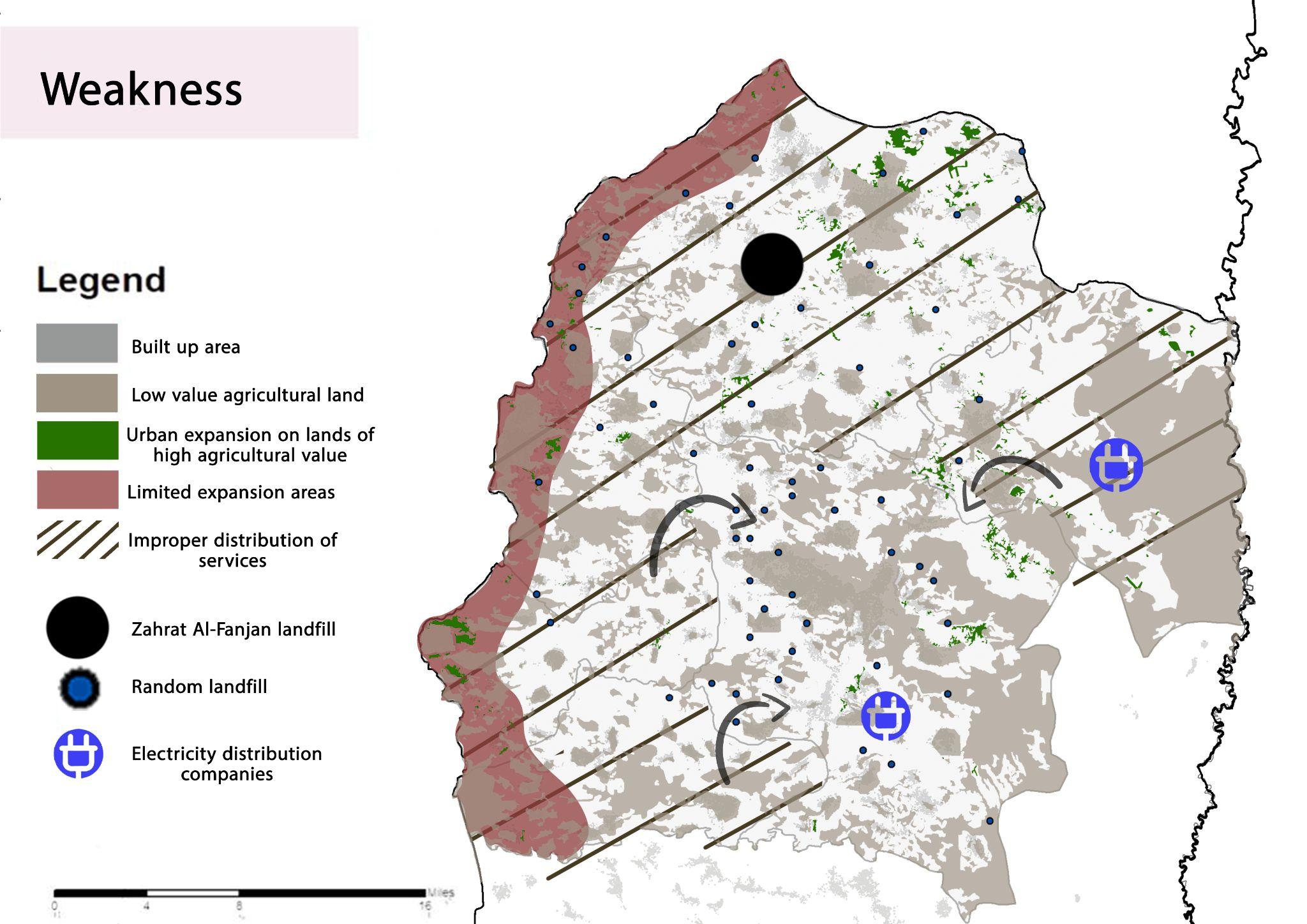
Northern region has a bad distribution in services, mostly services are located in city centers with neglecting the rural and surrounding areasasinthemap(16).
Tow electricity distribution companies are found as in the map(18), and the area has an electricity transfer station in Sarrah and Aljalamah. Some of the cities usessolarpanelstoproduserenewableenergy.
Map (15): Topography
Source : Geomolg,2021, Edited by the students
Map (16): Economy and Services
Map (17): LAndfills
Source : Geomolg,2021, Edited by the students
Source : Geomolg,2021, Edited by the students
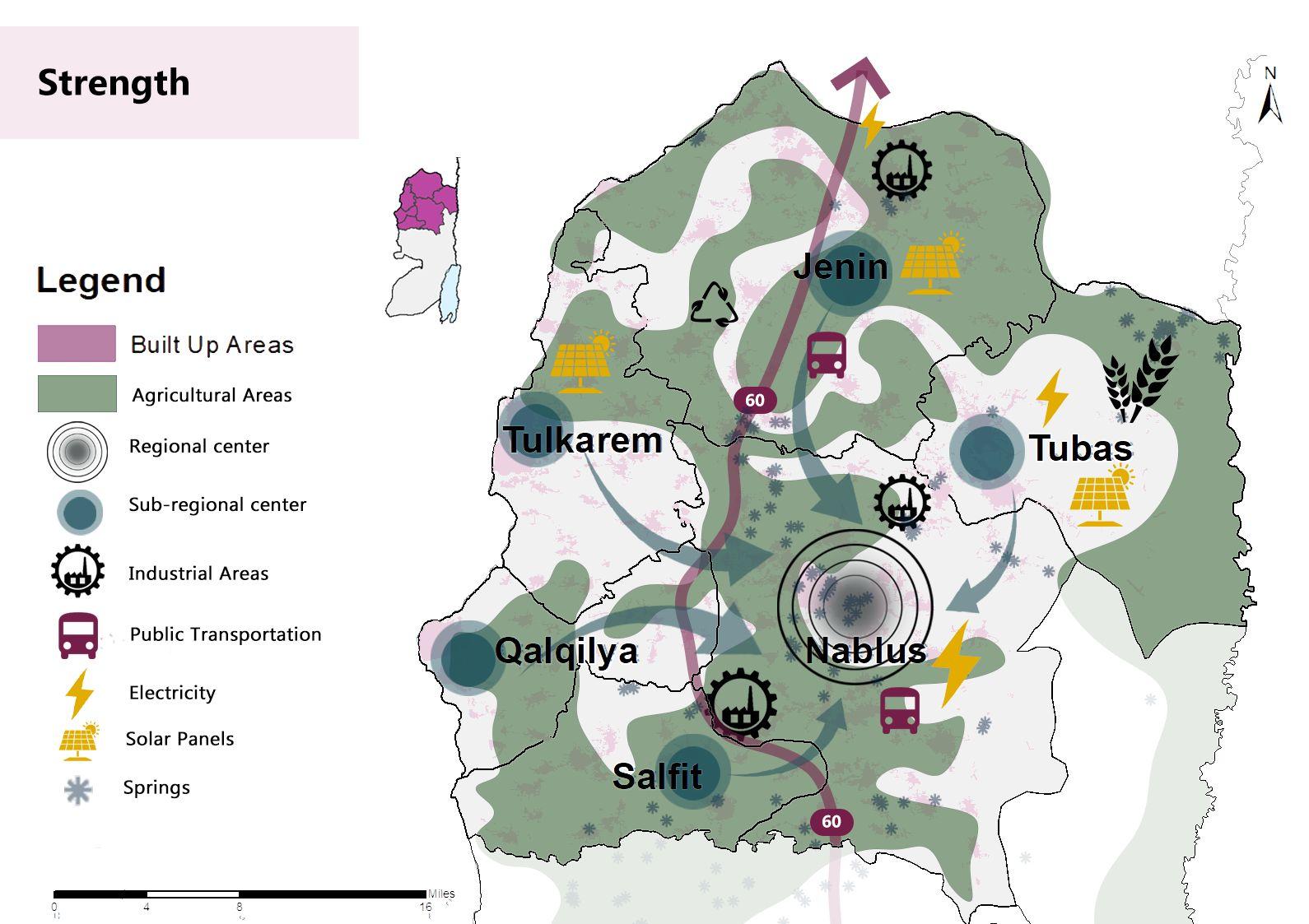
Strengths
Strengths
● A strong economy, especially in Nablus governorate, due to the presence of regional services
● The existence of industrial zones in the governoratesofNablusandJenin
● There are tourist areas in Nablus (the old city), theJordanValley,agriculturallandsinTubas,and marketsinJenin
● The location of the gatherings near the main streetssuchas60.Street
● The unemployment rate is high in Jenin and Salfit20%andNablus16.8%
● There are no commercial centers serving SalfitandQalqilyagovernorates
● Agricultural lands of low agricultural value are weak in terms of agriculture and plant wealth
● Random burials and dependence on one landfill,andthisleadstoahealthhazard
● Drillingnewwells,
● Connecting networks of communities to purificationplants
● Eyesourcesconfiscated
● Reliance on the import of energy and the presence of distribution companies and thereisnoenergyproduction.
Opportunities
Opportunities Threats
● Existence of low-value agricultural lands to beusedasareasforurbanexpansion
● The possibility of joint planning, making a future expansion based on a study and prior planning, and the possibility of expanding in theeasternpartoftheWestBankinTubas
● Multiple entrances in the study area with the occupiedland
● Expansion of networks to include all localities, road expansion and maintenance, suggestion of alternative roads, the possibility of increasing the efficiency of transportation in some areas such as Salfit QalqilyaandTulkarm
● Increasing employment opportunities in areaswithweakemployment
● Existence of lands of medium agricultural valueforagriculturalexploitation
● Drillingnewwells,
● Connecting networks of communities to purificationplants
● The presence of distribution stations proposed to move towards the use of solar cells
Threats
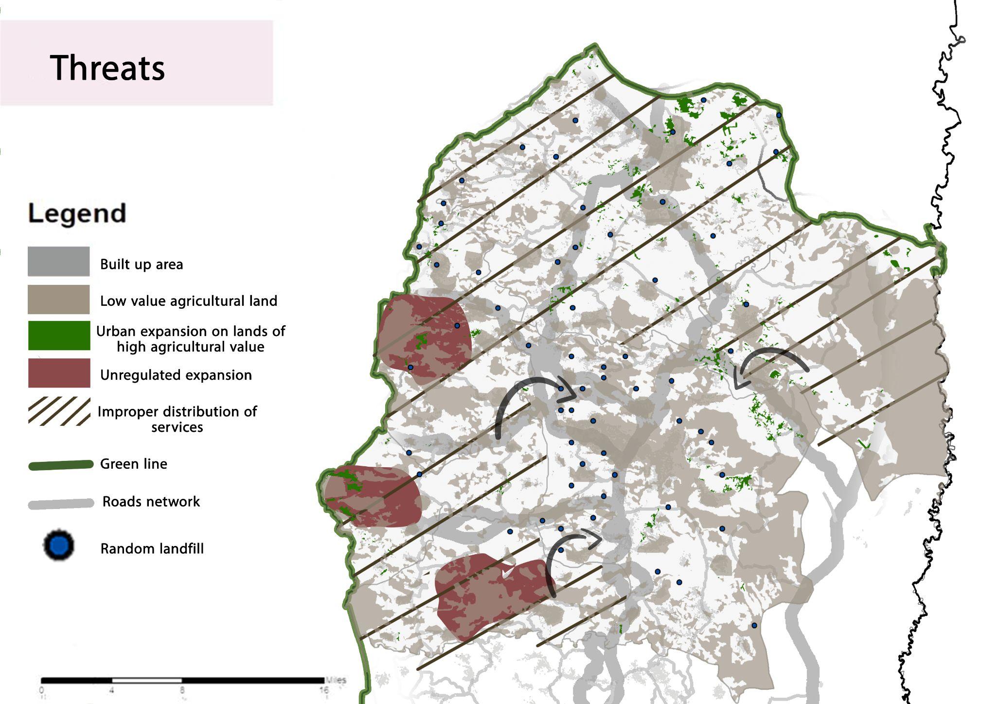
● The inability of the localities to absorb the futureexpansionoftheirlimitedlands,such asQalqilya
● The emergence of a random pattern in the future due to an unorganized division of land
● The current road network does not accommodate the future population expansion, the streets are unpaved, and there is a weakness in the infrastructure of thestreetnetwork
● Decreased job opportunities and high unemploymentrate.
● Urban growth and expansion towards villages pose a threat to the preservation of ruralcharacterandagriculturallands
● Groundwater pollution and the destruction of the surface environment due to the lack of sewage networks, and the filling of wells bytheIsraelioccupationauthorities
● Lack of electricity pumping by Israeli companies
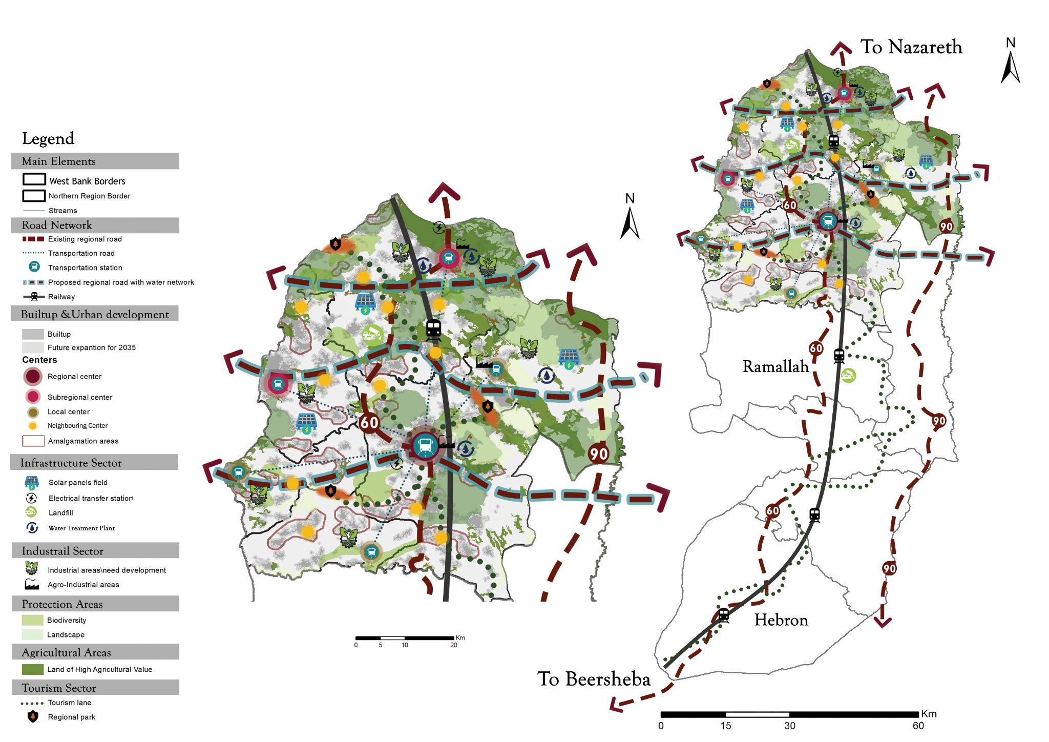
A self-sufficient northern area with joint planninglinkedtoamajorregionalserviceand commercial center (Nablus), sub-regional
Map (23): Conceptual Map
Source : Geomolg,2021, Edited by the students
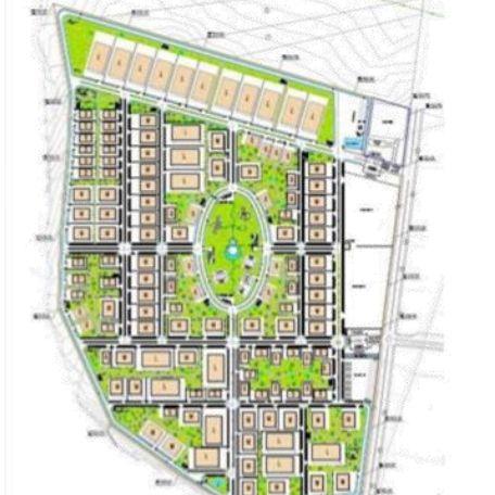
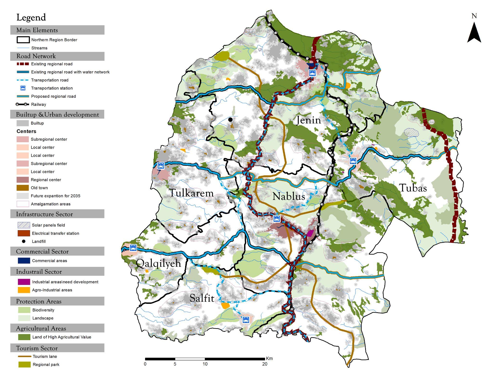
Master Plan
Each governorate was distinguished with a specific character in order to arrange and distribute services, so the levels classifications was arranged for each urban center as follows ; regional, sub-regional and local centers . In the transportation sector, a regional streets from east to west was proposed , which would feed the eastern region in particular, with a longitudinal railway linking all of the West Bank, not just the northern region.Public transportation has been improved and a system has been
Map (24): Conceptual Map
Source : Geomolg,2021, Edited by the students
Conclusion
The ideas and concepts of regional planning were examined as they were applied to the West Bank. The regional planning process was followed in the paper. There is a wide range of issues that affect the West Bank as a whole, and those issues may be found in each of these factors: urban/rural context, economics, unbalanced decentralization of services and future growth and extension are all aspects of infrastructure. This leads us to the need of a new master plan, which the paper suggested a vision that is based on the analysis, later on the master plan was proposed.
References:
- Daniels, Thomas, 1998, When City and Country Collide: Managing Growth In The Metropolitan Fring, Growth Management Strategies and the Law of the Fringe.
- Geospatial information system in Palestine, 2021
- Johnson, David, 2015. History of Regional Planning
- Palestinian Central Statistics Authority, Estimated Population in Palestine by Governorate, 1997 - 2021
- Perloff, Harvey, 2007. Key Features of Regional Planning
- Silva, Carlos, 2015. Planning Ethics
- Statistics of the Ministry of Transport and Communications, 2020
- The National Information Center, Wafa, Agricultural Regions in the Palestinian Territories, 2019
- The National Information Center, Wafa, Water and Sanitation in Palestine, 2017