Contact Information
Email: xiaoranzhang619@gmail.com
Cell: NL: +31 6 57212791 US: +1 (412)-519-4283
Address: Coolsestraat 82, 3014 LN Rotterdam, Netherlands
Studio Team Research Instructor: Prof. Stefan Gruber, Prof. Jonathan Kline Duration: 09/2020 - 12/2020
Team : Clover Chau, Sharleen Devjani, Cassandra Howard, Longney Luk, Sameedha Mahajan, Bingjie Sheng, Harvest Su, Yashasvi Tulchiya, Yiya Wang, Xiaoran Zhang
Role in Team: Case study and toolkit development, worked on individual vision and proposal.

Commoning the City is a research-based-design studio focused on the bottom-up transformation of cities and explores how designers and planners can tap into the self-organizing behavior of cities in order to empower citizens to claim their right to the city.
In the year of 2020, the studio focused on conceptualizing neighborhoods as commons, with a particular scrutiny towards contemporary notions of community in relation to the school wide theme of propinquity, also in corresponse to the the COVID-19 pandemic exploring many alternative solutions tackling the existing emergent chanllenges.

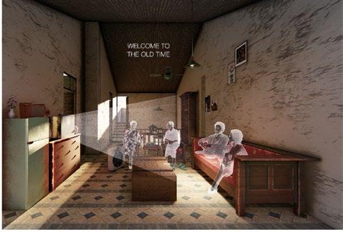
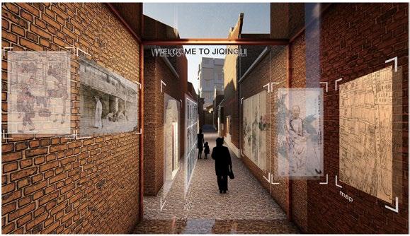
Case study is one of the most significant practices in the first semester team research process. By studying the community cases from the international setting, the research team can build a solid toolkit—ranging from concepts to spatial design methods and practical experiences. These tools will aid the students in re-imagining the methodologies of architecture and urban design: shifting from an obsession with form to exploring collaborative design, from the authoritarian control of design rights to open and participatory design, and from an excessive focus on construction details to viewing randomness and uncertainty as new opportunities. Each case study is illustrated as a composition of there layers of scales. The background is usually a regional mapping practice with diagram interpreting the understanding of the macro mechanisms of how the project works from social, economical and political perspectives. The middle ground analyzes the spatial structure from design and program perspectives, and the foreground demonstrates the social scene with diverse activities from the communities. In the class, the research team was able to discuss and learn from different case studies, refine the case study posters, and later contribute to the case study toolkit.


Commoning Cards
The commoning cards practice is a newly created research process in the fall of 2020. The creation of the card set is to develop a participatory toolkit for not only designers, but all the participants with non-design background to understand the commoning concepts and new strategies towards decision making and resource sharing. During the mid-term review, a discission session happened using this card set as a classification tool identifying each of the topics around the difinition of commoning.


Site Visits and Visioning
Although during COVID-19 pandemic, international site visit trip was canceled, the studio still had the chance to make two site visits to the local projects (Garfield Community Farm and The Octopus Garden, Pittsburgh), with a focus on local placemaking, selfsufficiency and sustainability.
With the inpsirations from the case studies and site visits, was able to create a collage, mostly using the characters from the case studies to illustrator an initial vision for my thesis proposal.

Full Link: https://pittsburghair.cargo.site/
Studio Team Research Instructor: Prof. Nida Rehman Duration: 01/2020 - 05/2020
Team : Sameedha Mahajan, Harvest Su, Yashasvi Tulchiya, Yiya Wang, Xiaoran Zhang Role in Team: Researched on city air pollutant sources - developed storytelling sectional maps.
The studio research project Soot and the City explores Pittsburgh’s air quality through urban design, focusing on how the built environment contributes to and can mitigate air pollution. By examining materiality, form, and development processes, the project highlights the stories of underprivileged communities. Using multi-scale mapping, it explores potential interventions for addressing environmental justice issues in the city.
Neighborhood Study

“I will never forget the first time experienced that smell”
“We need to operationalize actions we can take now to address this problem”
“There are so many statistics in here I was floored with. I’m shocked to learn how bad this problem is”

Plants

Valley
This map overlays median income with childhood asthma rates, and we see a pattern of environmental injustice happening along the river and around the hill district.
Income & Health Map

“I had run two marathons, and I couldn’t get up and down the stairs without my inhaler here” “It was dangerous to sleep with the windows open at night because you didn’t want to be awoken by the stench”

Cheswick and Springdale Boroughs

windowsills, dirt on my furniture. It’s a constant cleaning. Filthy. It’s a filthy place to live, and we’re breathing this in”
“It’s like hell. Living in hell. It’s filthy; it’s dirty; it’s noisy—it’s unhealthy”
“The smoke is always there. Wherever you go, you see it”
“Living next to a coal plant is like a neighbor from hell just moved in”
Vermont Homes for All Toolkit
Urban Planning and Design Project in Utile, Inc, with State of Vermont
Location: State of Vermont
Status: Complete - adopted
Duration: 06/2023 - 03/2024
Role in Team: Urban design lead- developed spatial analytical workflow on community site selection and visualizations for housing typology infill studies.
Vermont’s home production is principally producing large and expensive single-households. The housing options in-between, like a duplex or fourplex, cooperative housing, senior housing units, age-friendly homes, or townhouse condominiums are very limited. With the goal of alleviating regulatory and financial complocations of developing diverse homes on a small footprint for local residents, a systematic overview from development to design of new Missing Middle Homes (MMH) typologies in local communities was introduced in this toolkit.

The purpose of community case studies was to explore how the environmental, infrastructural, design, and regulatory characteristics of each community interacted with the developed Missing Middle Home typologies, which is a process of “groundtruthing” how these proposed home typologies best fit into the actual physical and regulatory conditions.


Infill Site Selection and Home Typology Test-fit
For the community infill design case studies, worked on developing a comprehensive spatical analysis workflow for better understanding of community environmental and regulartory constrains for missing middle home development, and identification and selection of infill focus areas with high development potentials. Additionally, participated the local site visits for each community and interviews with each property owner for finally identified infill sites, in order to better understand different site conditions and develop a hypothetical infill test-fit for each community. The test-fit visualizations illustrate an approach to bringing new Missing Middle Homes to that community through site plan and perspective rendering, along with the regulatory information and development metrics listed.

MBTA Communities Multi-Family Zoning Technical Assistance
Urban Planning and Design Project in Utile, Inc, with Massachusetts Housing Partnership
Location: State of Massachusetts
Status: In progress
Duration: 11/2023 - 09/2024
Role in Team: Urban Planning Analyst - worked on zoning schemes and calculations to make sure communities’ zoning submission compliant, and visualize 3D buildout scenarios.
Over the course of 2023 and 2024 Utile has been working with a communities across Massachusetts to develop local responses to the statewide MBTA Communities policy, which was enacted to address the statewide housing crisis. The policy requires all communities with MBTA public transit access to have at least one zoning district of reasonable size in which multi-family housing is permitted by-right and meets other criteria set forth in the statute such as a minimum gross density, and specific contiguity and transit station area relationships.
As a planning analyst in the consulting team providing technical support, urban design and engagement, worked closely with public agencies, using data visualization tools including GIS systems and Rhino to create zoning scenarios and models. Other than technical and design support, one notable challenge is to integrate and balance housing production goals with the preservation of valuable community retail, commercial, and industrial uses.


toolkit for housing creation calculation and model compliance


City of Newton On-Call Zoning Assistance
The zoning redesign work began with testing an existing draft form-based code. Utile analyzed the proposed zoning in residential districts, creating illustrations to clearly present the impacts to the Zoning and Planning Committee (ZAP) for feedback and refine the code to suit the needs of stakeholders.
As the urban designer and planning analyst, prepared the submission materials for the proposed zoning scenario in response to MBTA Communities Zoning Policy, and developed perspective visualizations for development schemes following proposed form-based code.


Watertown Square Area Plan
The Watertown Square Area Plan explores all physical and human-centered aspects of the study area, with a special emphasis on the configuration and design characteristics of the public realm – including streets, sidewalks, and open spaces – and the buildings that define and activate it.
In the urban planning and design team, worked as a planning analyst conducting existing site analysis, calculating and proposing zoning schemes in response to both form-based code and the MBTA Communities Law.

Town of Cohasset Zoning Technical Support
The town of Cohasset, located in Norfolk County, Massachusetts, is intersected by a commuter rail line and must comply with the MBTA Communities Law to meet multifamily housing creation goals. Given the town’s low-density character and the presence of environmentally sensitive wetlands, extensive discussions arose about balancing the priorities of creating new housing and preserving existing community assets.
As a planning analyst, supported the technical consulting team to develop and evaluate multiple zoning scenarios. This involved creating maps, building calculation models, and visualizing potential development outcomes. The goal was to identify the most balanced solution that supports housing creation while preserving the town’s valued assets.


The Andover Comprehensive Plan: Envision, Preserve, Enhance
Urban Planning and Design Project in Utile, Inc, with Town of Andover
Location: Andover, MA, US
Status: Complete - adopted
Duration: 01/2023 - 08/2023
Role in Team: Urban designer - worked on existing spatial analysis, town planning vision maps and developed urban design scenarios for priority districts.
A Comprehensive Plan is a planning tool which develops a strategic vision and road map for the Town’s future. As the Town of Andover prepares for the coming decades after last completed comprehensive plan in 2012, the design team worked with the town in a 2-year time frame to help better understanding the existing development and planning policies, enhancing local character, and developing a road map for the town to broaden policies and create urban development visions, which will reflect the values and goals for residents, business owners and other key stakeholders.
Existing Spatial Analysis
Existing Analysis - Mobility and Transportation Network

Development Prototypes
The designed prototype scenarios help contextualizing the planning strategies. Focusing on large-scale industrial office parks, the design emphasizes creating an environment with better mobility and accessibility, as same as job creations to the community. As an opportunity for providing more housing to the town, the housing infill scenario illustrates opportunity zones where smaller-scale neighborhoods can locate closer to the commuter rail and riverfront.
Prototype Design - Industrial - Office Park
Riverfront Opportunity Zones
Existing Analysis - Environment & Ecosystem


Vision Planning and Urban Design


“Learning from present” is the first step of visioning planning and scenario design. Based on comprehensive understanding of databases, I created a series of maps to visualize where most opportunities and challenges exist in the town: Shawsheen River, as the most important corridor of the town, brings the highest potential for local development and peacemaking, as same as facing the complication of zoning, transportation and ecosystem.
Following public hearings and community engagement, my team initiated the visioning and design process, incorporating feedback gathered from workshops and surveys. As a community-driven plan, it reflects the priorities identified by residents: “Grow along Interstate 93, Enhance along the Shawsheen River, and Connect East to West.”

Prototype Design - Industrial - Housing Infill


Pittsburgh Green Space System Optimization Design
Urban Design Media Lab Work Instructor: Prof. Nico Azel Duration: 01/2020 - 05/2020
Downtown Pittsburgh experiences high air pollution, primarily from traffic and industrial emissions, which negatively affects public health. Green spaces can act as natural air filters, reducing pollution and improving urban air quality. Through data analytical and visualization tools, the project strategically proposed a green space system that is better connected and allows multiple micro-scale interventions to exist.
Walking Accessibility Network Evaluation Issuu
Comparing the 5-minute walksheds between the current situation and the proposed design scenarios reveals that most of the previously underserved areas are now within accessible walking distances due to the added green spaces. These enhancements create a more cohesive spatial network, particularly along the riverfront, which gains increased connectivity and ecologica benefits from the newly integrated green spaces. Similarly, an analysis of the isovist view range shows a significant improvement in visual connectivity, with a more continuous and expansive line of sight along the river. This fosters a stronger sense of openness and accessibility, contributing to a more inviting and integrated urban environment.
Isovist View Range Evaluation
In this scenario, more accessible entrances can and recreation components can reform the walking and cycling trail along the river.

In this scenario, filtration components can reduce the air pollution along the river and bring more renewable energy installations.
In this scenario, filtration components can reduce the spread of air and noise pollution along the highway.
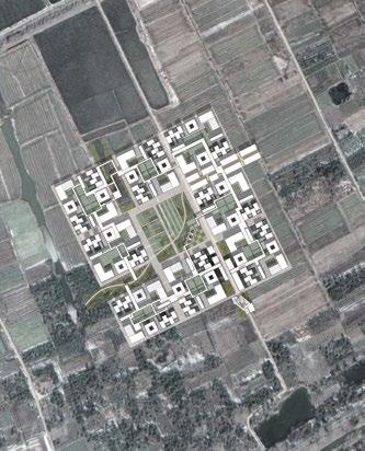
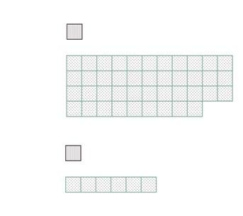
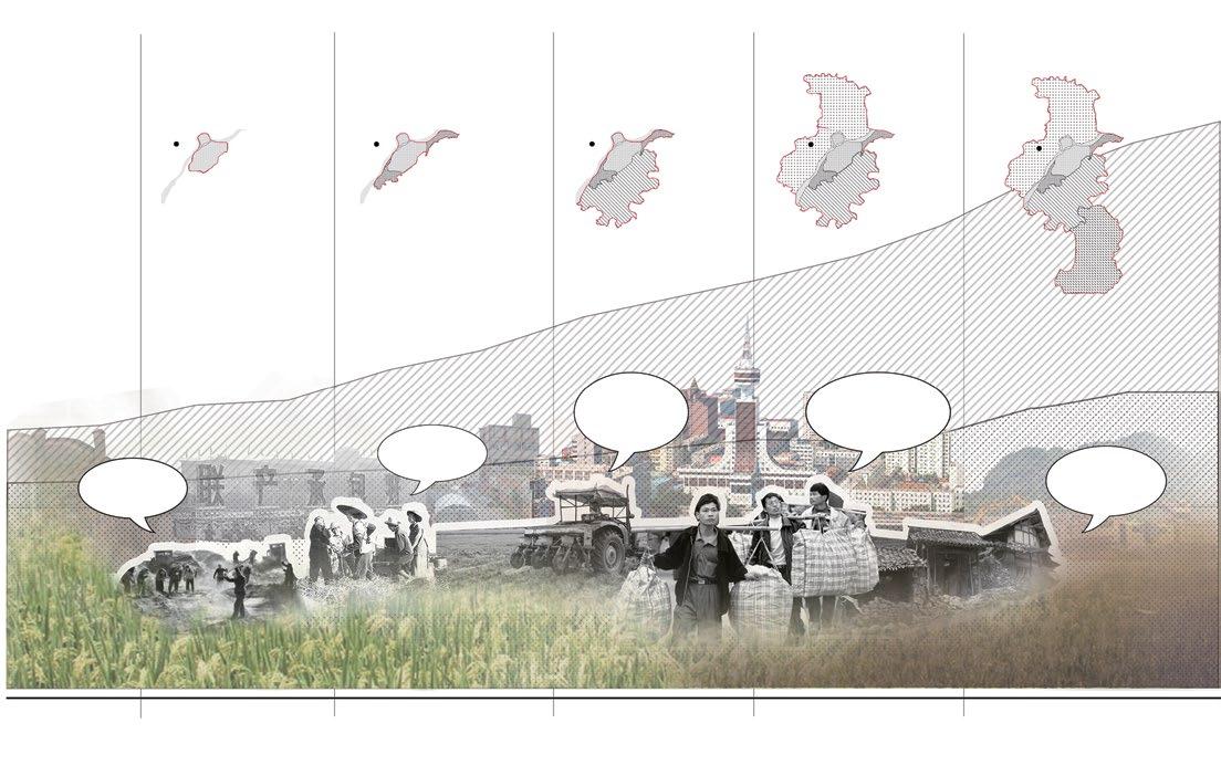
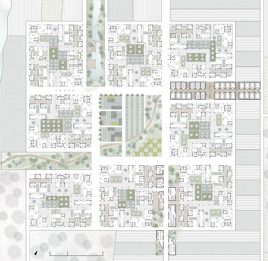
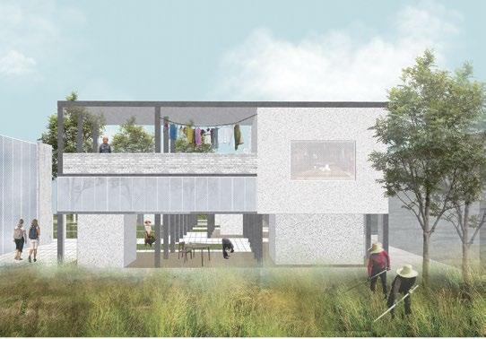
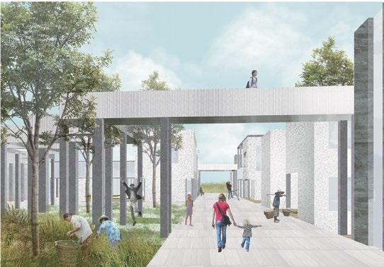
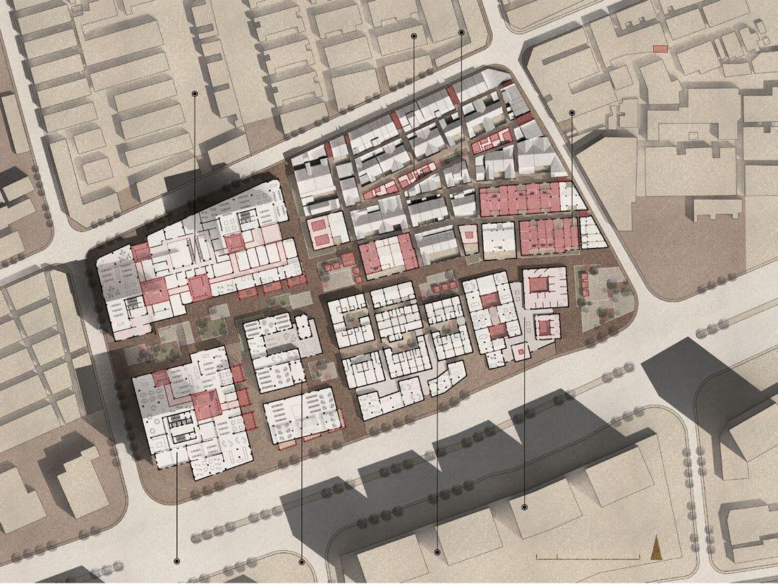
Instructor: Prof. Renchao Luo, Zhou Xu Site: Nanjing, China
Duration: 03/2017 - 06/2017 Individual
This project envisions a rural cooperative system through diverse housing types. It reconnects villagers and urban residents with shared living spaces and public areas, fostering a locally-driven live-work community. By leveraging nearby tourism resources, it boosts the local economy and builds connections between travelers and residents, preserving the traditional rural lifestyle while revitalizing the village economy in a modern, sustainable way.