Green Roads for Water

Page 120

96 | Green Roads for Water
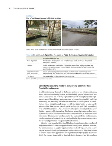
PHOTO 5.8

Use of turfing combined with jute netting

Source: © The Vetiver Network. Used with permission. Further permission required for reuse.

TABLE 5.4  Recommended

practices for roads as flood shelters and evacuation routes

RECOMMENDED PRACTICE

Road alignment

Prioritize the development and heightening of roads leading to designated emergency shelters.

Polders

Create heightened road bodies in low-lying areas of the polder to create safe routes and safe temporary shelters during flood events and refuge areas in the post-flood scenario.

Embankment and flood protection

Create levees along vulnerable sections of the roads to protect roads and embankments and create flood and post-flood shelters for humans and livestock.

Evacuation

Plan evacuation routes using road infrastructure.

Source: MetaMeta (www.roadsforwater.com).

Consider levees along roads to temporarily accommodate flood-affected persons In addition to raising the roads in the lowest sections of low-lying coastal areas, levees may be created along internal roads and along specific embankment sections. These levees can shelter people and livestock during floods and high-­ water events. These higher sections should be created in especially high-risk areas using the remaining silt from the excavation of canals, ponds, or rivers. Such sections along the roads could provide the opportunity to temporarily accommodate flood victims (people, cattle, and goods) until their homes have been rehabilitated (photo 5.10). Levees should be spaced at strategic distances so that they are accessible throughout flood-prone areas, placing them along more exposed sections of flood embankments so they can serve as additional reinforcements. The same may also be done for the area outside the embankments. Finally, use of these levees should be regulated by local governments to prevent the undesired permanent occupation of flood shelters. Plans for emergency facilities should be based on estimates of the number of people and livestock that will depend on them during floods. As a rule of thumb, the minimum space needed for a person to take shelter lying down is 1.5 square meters. Although that is sufficient space over the short term, 3.5 square meters of covered area is more appropriate for longer-term emergency space (Red Cross 2013). An average household in Bangladesh, for instance, has 4.6 members


Turn static files into dynamic content formats.

Create a flipbook

Articles inside

Ethiopia

3min
pages 254-255

A.1 Making a community map

1min
page 262

15.3 Road maintenance group using work safety measures, Nepal

1min
page 256

A.2 Transect walk

1min
pages 263-265

15.2 How to engage communities in road development

4min
pages 252-253

15.1 Different stages in community engagement

12min
pages 246-250

Examples of community engagement at scale

2min
page 251

15.1 The scope for community engagement under different roads programs

5min
pages 243-244

water sector, agriculture, and universities, Malawi

1min
page 237

Note

1min
pages 239-240

Scope for community engagement

2min
page 242

for road programs

2min
page 238

Getting the process going Annex 14A. Sample supplemental terms of reference

2min
page 236

Governance for roads for water

2min
page 232

Conclusions

6min
pages 222-223

of seedlings

1min
page 220

Combining water harvesting and tree planting

3min
pages 217-218

12.2 Roadside tree barriers and dust movement

1min
page 216

Design of roadside vegetative barriers

2min
page 215

12.1 Roadside vegetation and road safety measures

1min
page 213

12.1 Tree planting and road visibility

1min
page 212

Opportunities

2min
page 209

Site selection

2min
page 211

Recommended practices

1min
page 210

11.1 Infiltration rates of different soils

7min
pages 197-199

References

1min
pages 205-206

11.3 Suitable pond side slopes for different soils

6min
pages 202-204

References

1min
page 192

Recommended practices

1min
pages 195-196

10.3 Rolling drainage dip in low-volume road

1min
page 190

Opportunities

2min
page 183

Recommended practices

8min
pages 184-187

8.1 Geotextile materials for reservoir lining

1min
page 169

Opportunities Recommended practice: River crossings as sand dams and bed

1min
page 172

9.2 Overview of nonvented drift with preventable failure features

1min
page 178

Recommended practices

13min
pages 162-168

Opportunities

2min
pages 160-161

Recommended practices and preferred options

5min
pages 149-151

7.1 Road culvert spacing and dimensions for floodplains

6min
pages 152-154

Alternative road option in floodplains: Submersible roads

1min
page 155

References

1min
pages 145-146

Opportunities

1min
page 148

Notes

2min
page 144

6.7 Technique for creating artificial glaciers in mountain areas

2min
pages 142-143

6.6 Snowshed in Alpine environment

1min
page 141

6.3 Recommended practices for spring management along roads

1min
page 138

6.4 Infiltration bunds

1min
page 136

6.2 Effect of road development on different types of springs

3min
page 137

5.2 Minimum cross-drainage opening for Bangladesh lowlands

9min
pages 110-115

routes

4min
pages 120-122

Changing the mountain environment

2min
pages 127-128

6.2 Tilted causeways

1min
page 134

6.3 Dissipation block placement on the road

1min
page 135

Opportunities

4min
pages 104-105

Recommended best practices

2min
page 106

3.1 Typical concentrations of pollutants in highway runoff

2min
page 65

4.11 Water-spreading weir, Ethiopia

1min
page 100

Kotomor, Agago (northern region, Uganda

1min
page 99

4.2 Fodder grown from road culvert water, South Gondar, Ethiopia

1min
page 87

Techniques for road-water harvesting

2min
page 89

Road safety principles

2min
page 88

Amhara, Ethiopia, 2018

1min
page 85

3.2 Roadside spring with inadequate collection reservoir, Sardinia, Italy

1min
page 76

Recommended practices

9min
pages 66-69

Opportunities

2min
page 64

Notes

1min
page 60

References

2min
pages 61-62

2.4 V-shaped floodwater spreader

4min
pages 58-59

harvesting

3min
page 57

Recommended practices

2min
page 51

References

2min
pages 43-46

The three levels of promoting resilience: Protective, adaptive, and proactive

2min
page 34

3 Drift construction in sand river bed: General section of nonvented

2min
page 33

Road safety considerations

5min
pages 41-42

The benefits and costs of roads for water

2min
page 35

1.2 Three levels of road resilience for different road elements

2min
page 37

2 Community mobilization for road-water harvesting in Amhara

2min
page 39

3 Roadside spring opened after road construction in Tigray, Mulegat

1min
page 27

Changing the paradigm: Concept and principles of roads for water

4min
pages 31-32
Issuu converts static files into: digital portfolios, online yearbooks, online catalogs, digital photo albums and more. Sign up and create your flipbook.
Green Roads for Water by World Bank Publications - Issuu