Data and Methodology l 51
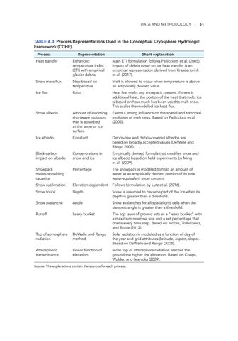
TABLE 4.3 Process Representations Used in the Conceptual Cryosphere Hydrologic Framework (CCHF) Process
Representation
Short explanation
Heat transfer
Enhanced temperature index (ETI) with empirical glacier debris
Main ETI formulation follows Pellicciotti et al. (2005). Impact of debris cover on ice heat transfer is an empirical representation derived from Kraaijenbrink et al. (2017).
Snow mass flux
Step based on temperature
Melt is allowed to occur when temperature is above an empirically derived value.
Ice flux
Ratio
Heat first melts any snowpack present. If there is additional heat, the portion of the heat that melts ice is based on how much has been used to melt snow. This scales the modeled ice heat flux.
Snow albedo
Amount of incoming shortwave radiation that is absorbed at the snow or ice surface
Exerts a strong influence on the spatial and temporal evolution of melt rates. Based on Pellicciotti et al. (2005).
Ice albedo
Constant
Debris-free and debris-covered albedos are based on broadly accepted values (DeWalle and Rango 2008).
Black carbon impact on albedo
Concentrations in snow and ice
Empirically derived formula that modifies snow and ice albedo based on field experiments by Ming et al. (2009).
Snowpack moisture-holding capacity
Percentage
The snowpack is modeled to hold an amount of water as an empirically derived portion of its total water-equivalent snow content.
Snow sublimation
Elevation dependent
Follows formulation by Lutz et al. (2016).
Snow to ice
Depth
Snow is assumed to become part of the ice when its depth is greater than a threshold.
Snow avalanche
Angle
Snow avalanches for all spatial grid cells when the steepest angle is greater than a threshold.
Runoff
Leaky bucket
The top layer of ground acts as a “leaky bucket” with a maximum reservoir size and a set percentage that drains every time step. Based on Moore, Trubilowicz, and Buttle (2012).
Top of atmosphere radiation
DeWalle and Rango method
Solar radiation is modeled as a function of day of the year and grid attributes (latitude, aspect, slope). Based on DeWalle and Rango (2008).
Atmospheric transmittance
Linear function of elevation
More top of atmosphere radiation reaches the ground the higher the elevation. Based on Coops, Wulder, and Iwanicka (2009).
Source: The explanations contain the sources for each process.


