July 2021
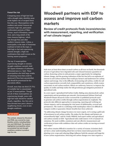
Forest fire risk Comparing areas of high fuel load with a drought index identifies areas at the highest risk of escaped forest fires this year. Municipalities in the southern and central Amazon are extremely high risk, particularly northwestern portions of Mato Grosso, much of Rondonia, eastern Acre, and a long stretch of the trans-Amazon highway, which cuts through Para and other southern Amazon states. Lábrea, a municipality in the state of Amazonas (outlined in bold on the map), is both high in fuel and experiencing extreme drought, a high-risk combination that could worsen as the burning season progresses. The top 10 municipalities experiencing drought or extreme drought conditions currently hold 283 square kilometers of unburned, deforested area (i.e. fuel). These municipalities also hold large swaths of remaining forest that could be destroyed if fires burn uncontrolled, and should be prioritized for fire prevention efforts. Overall, more than one third (35.5%) of available fuel is concentrated in just 10 municipalities. Though not all of these municipalities are experiencing drought, areas with high fuel loads should be watched closely, regardless. Any fires set to burn downed trees pose a threat to neighboring forests, even in nondrought conditions. IN THE NEWS
This outlook, released by Woodwell and IPAM, was covered by major Brazilian outlets, including Globo. com and CNN Brazil. The analysis highlighted municipalities where accumulated fuel and drought conditions combine to produce high fire risk.
03
Woodwell partners with EDF to assess and improve soil carbon markets Review of credit protocols finds inconsistencies with measurement, reporting, and verification of net climate impact
Soils store at least three times as much carbon as all trees on Earth, but thousands of years of agriculture have degraded soils and released immense quantities of carbon. Restoring carbon in soils presents a major opportunity for mitigating climate change, and the growing realization of this fact has led to an explosion of interest in soil carbon markets that would pay farmers and landowners for carbon capture and storage. Due to the difficulty of measuring soil carbon, credits for soil carbon sequestration currently lack comparability and consistency, which creates uncertainty in soil carbon markets. Efforts are underway, however, to improve the quality of credits and help realize the full greenhouse gas mitigation potential of agricultural soils. In a new report—Agricultural Soil Carbon Credits: Making sense of protocols for carbon sequestration and net greenhouse gas removals—Environmental Defense Fund and Woodwell Climate Research Center reviewed the 12 published protocols used to generate soil carbon credits through carbon sequestration in croplands. The protocols take different approaches to measuring, reporting and verifying net climate impacts, and to managing the vital issues of additionality, reversal and permanence. The result is a confusing credit marketplace where it is difficult to compare credits or guarantee climate benefits have been achieved. “As addressing climate change becomes ever more urgent, we’re seeing a gold rush of investment in soil carbon credits. The stakes for the climate and farmers are extraordinarily high,” said Dr. Emily Oldfield, lead report author and agricultural soil carbon scientist at EDF. “Agricultural soils could remove 4-6% of annual U.S. emissions. We need credible, consistent and cost-effective measurement and verification to know with confidence that soil carbon credits are moving us toward that target.” Soil carbon remains difficult to monitor for a variety of reasons. Scientists don’t yet have a clear understanding about how on-farm conservation practices like planting cover crops and reducing tillage influence both the amount and longevity of new carbon sequestration. Detecting soil carbon changes over time requires a


