

that had begun to deregulate their foreign exchange and capital markets. The economic integration and globalization that began in the eighties is picking up speed in the 1990s via privatization. Privatization is the process by which a country divests itself of the ownership and operation of a business venture by turning it over to the free market system Trade liberalization and economic integration continued to proceed at both the regional and global levels. In Europe, many EU member countries have adopted the common currency, euro, that has become the
second global currency after the U S dollar
4. How is a country’s economic well-being enhanced through free international trade in goods and services?
Answer: According to David Ricardo, with free international trade, it is mutually beneficial for two countries to each specialize in the production of the goods that it can produce relatively most efficiently and then trade those goods By doing so, the two countries can increase their combined production, which allows both countries to consume more of both goods This argument remains valid even if a country can produce both goods more efficiently than the other country International trade is not a ‘zero-sum’ game in which one country benefits at the expense of another country Rather, international trade could be an ‘increasing-sum’ game at which all players become winners.
5. What considerations might limit the extent to which the theory of comparative advantage is realistic?
Answer: The theory of comparative advantage was originally advanced by the nineteenth century economist David Ricardo as an explanation for why nations trade with one another. The theory claims that economic well-being is enhanced if each country’s citizens produce what they have a comparative advantage in producing relative to the citizens of other countries, and then trade products. Underlying the theory are the assumptions of free trade between nations and that the factors of production (land, buildings, labor, technology, and capital) are relatively immobile. To the extent that these assumptions do not hold, the theory of comparative advantage mayl not realistically describe international trade.
6. What are multinational corporations (MNCs) and what economic roles do they play?
Answer: A multinational corporation (MNC) can be defined as a business firm incorporated in one country that has production and sales operations in several other countries. Indeed, some MNCs have operations in dozens of different countries. MNCs obtain financing from major money centers around the world in many different currencies to finance their operations. Global operations force the treasurer’s office to establish international banking relationships, to place short-term funds in several currency denominations, and to effectively manage foreign
exchange risk.
7. Ross Perot, a former Presidential candidate of the Reform Party, which is a third political party in the United States, had strongly objected to the creation of the North American Trade Agreement (NAFTA), which nonetheless was inaugurated in 1994. Perot feared the loss of American jobs to Mexico where it is much cheaper to hire workers What are the merits and demerits of Perot’s position on NAFTA? Considering the recent economic developments in North America, how would you assess Perot’s position on NAFTA?
Answer: Since the inception of NAFTA, many American companies indeed have invested heavily in Mexico, sometimes relocating production from the United States to Mexico. Although this might have temporarily caused unemployment of some American workers, they were eventually rehired by other industries often for higher wages At the same time, Mexico has been experiencing a major economic boom It seems clear that both Mexico and the U S have benefited from NAFTA Perot’s concern appears to have been ill founded
8. In 1995, a working group of French chief executive officers was set up by the Confederation of French Industry (CNPF) and the French Association of Private Companies (AFEP) to study the French corporate governance structure The group reported the following, among other things:
“The board of directors should not simply aim at maximizing share values as in the U K. and the U S Rather, its goal should be to serve the company, whose interests should be clearly distinguished from those of its shareholders, employees, creditors, suppliers and clients but still equated with their general common interest, which is to safeguard the prosperity and continuity of the company” . Evaluate the above recommendation of the working group.
Answer: The recommendations of the French working group clearly show that shareholder wealth maximization is not a universally accepted goal of corporate management, especially outside the United States and possibly a few other Anglo-Saxon countries including the United Kingdom and Canada. To some extent, this may reflect the fact that share ownership is not wide spread in most other countries. In France, about 15% of households own shares.
9. Emphasizing the importance of voluntary compliance, as opposed to enforcement, in the aftermath of such corporate scandals as those involving Enron and WorldCom, U S President George W Bush stated that while tougher laws might help, “ultimately, the ethics of American business depends on the conscience of America’s business leaders ” Describe your view on this statement
Answer: There can be different answers to this question If business leaders always behave with a high ethical standard, many of the corporate scandals we have seen lately might not have happened. Since we cannot fully depend on the ethical behavior on the part of individual business leaders, the society should protect itself by adopting the rules/regulations and governance structure that would induce business leaders to behave in the interest of the society at large.
10. Suppose you are interested in investing in shares of Nokia Corporation of Finland, which is a world leader in wireless communication. But before you make investment decision, you would like to learn about the company. Visit the website of Yahoo (http://finance.yahoo.com) and collect information about Nokia, including the recent stock price history and analysts’ views of the company. Discuss what you learn about the company. Also discuss how the instantaneous access to information via internet would affect the nature and workings of financial markets.
Answer: As students might have learned from visiting the website, information is readily available even for foreign companies like Nokia. Ready access to international information helps integrate financial markets, dismantling barriers to international investment and financing. Integration, however, may help a financial shock in one market to be transmitted to other markets
MINI CASE: NIKE AND SWEATSHOP LABOR
Nike, a company headquartered in Beaverton, Oregon, is a major force in the sports footwear and fashion industry, with annual sales exceeding $ 12 billion, more than half of which now come from outside the United States The company was co-founded in 1964 by Phil Knight, a CPA at Price Waterhouse, and Bill Bowerman, college track coach, each investing $ 500 to start The company, initially called Blue Ribbon Sports, changed its name to Nike in 1971 and adopted the “Swoosh” logo recognizable around the world originally designed by a college
Another random document with no related content on Scribd:
A visit to the family of a Tchuktche chief is thus described by one of Admiral Wrangell’s companions:—
We entered the outer tent, or namet, consisting of tanned reindeer-skins outstretched on a slender framework. An opening at the top to give egress to the smoke, and a kettle on the hearth in the centre, showed that antechamber and kitchen were here harmoniously blended into one. But where might be the inmates? Most probably in that large sack made of the finest skins of reindeer calves, which occupied, near the kettle, the centre of the namet. To penetrate into this “sanctum sanctorum” of the Tchuktch household, we raised the loose flap which served as a door, crept on all fours through the opening, cautiously refastened the flap by tucking it under the floor-skin, and found ourselves in the polog—that is, the reception or withdrawing-room. A snug box, no doubt, for a cold climate, but rather low, as we were unable to stand upright in it; nor was it quite so well ventilated as a sanitary commissioner would require, as it had positively no opening for light or air. A suffocating smoke met us on entering: we rubbed our eyes; and when they had at length got accustomed to the pungent atmosphere, we perceived, by the gloomy light of a train-oil lamp, the worthy family sitting on the floor in a state of almost complete nudity. Without being in the least embarrassed, Madame Leütt and her daughter received us in their primitive costume; but to show us that the Tchuktche knew how to receive company, and to do honour to their guests, they immediately inserted strings of glass beads in their hair.
Their hospitality equalled their politeness; for, instead of a cold reception, a hot dish of boiled reindeer flesh, copiously irrigated with rancid train-oil by the experienced hand of the mistress of the household, was soon after smoking before them. The culinary taste of the Russians, however, could not appreciate this work of art, and the Leütt family were left to do justice to it unaided.
The Tchuktche are polygamous. Their women are regarded as slaves, but are not badly treated. Most of the Tchuktche have been baptized, but they cling in secret to their heathen creed, and own the
power of the shamans, or necromancers. They form two great divisions: the reindeer, or wandering Tchuktche, who call themselves Tennygk; and the stationary Tchuktche, or Oukilon, who exhibit affinities with the Eskimos, and subsist by hunting the whale, the walrus, and the seal. The Oukilon are supposed to number 10,000, and the Tennygk about 20,000.
CHAPTER X.
HISTORICAL SKETCH OF ARCTIC DISCOVERY

n the reign of Henry VIII., Dr. Robert Thorne declared that “if he had facultie to his will, the first thing he would understande, even to attempt, would be if our seas northwarde be navigable to the Pole or no.” And it is said that the king, at his instigation, “sent two fair ships, well-manned and victualled, having in them divers cunning men, to seek strange regions; and so they set forth out of the Thames, the 20th day of May, in the nineteenth year of his reign, which was the year of our Lord 1527.” Of the details of this expedition, however, we have no record, except that one of the vessels was wrecked on the coast of Newfoundland.
In 1536, a second Arctic voyage was undertaken by a London gentleman, named Hore, accompanied by thirty members of the Inns of Law, and about the same number of adventurers of a lower estate. They reached Newfoundland, which, according to some authorities, was discovered by Sebastian Cabot in 1496, and here they suffered terrible distress; in the extremity of their need being reduced to cannibalism. After the deaths of a great portion of the crew, the survivors captured by surprise a French vessel which had arrived on the coast, and navigated her in safety to England.
But the true history of Arctic Discovery dates, as Mr. Markham observes, from the day when the veteran navigator, Sebastian Cabot, explained to young Edward VI. the phenomena of the variation of the needle. On the same day the aged sailor received a pension; and immediately afterwards three discovery-ships were fitted out by the Muscovy Company under his direction. Sir Hugh Willoughby was appointed to their command, with Richard Chancellor in the Edward Bonadventure as his second. The latter, soon after quitting England, was separated from the squadron, and sailing in a northerly direction, gained at last a spacious harbour on the Muscovy coast. Sir Hugh’s ship, and her companion, the Bona Confidentia, were cast away on a desolate part of the Lapland coast, at the mouth of the river Arzina. They entered the river on September
18, 1563, and remained there for a week; and “seeing the year far spent, and also very evil weather, as frost, snow, and hail, as though it had been the deep of winter, they thought it best to winter there.” But as day followed day, and week followed week, in those grim solitudes of ice and snow, the brave adventurers perished one by one; and many months afterwards their bleached bones were discovered by some Russian fishermen.
In the spring of 1556, Stephen Burrough, afterwards chief pilot of England, fitted out the “Search-thrift” pinnace, and sailed away for the remote north. He discovered the strait leading into the sea of Kara, between Novaia Zemlaia and the island Waigatz; but he made up his mind to return, because, first, of the north winds, which blew continually; second, “the great and terrible abundance of ice which we saw with our eyes;” and third, because the nights waxed dark. He arrived at Archangel on September 11, wintered there, and returned to England in the following year.
Twenty years later, on a bright May morning, Queen Elizabeth waved a farewell to Martin Frobisher and his gallant company, as they dropped down the Thames in two small barks, the Gabriel and the Michael, each of thirty tons, together with a pinnace of ten tons. They gained the shores of Friesland on the 11th of July; and sailing to the south-west, reached Labrador. Then, striking northward, they discovered “a great gut, bay, or passage,” which they named Frobisher Strait (lat. 63° 8’ N.), and fell into the error of supposing that it connected the Atlantic Ocean with the Pacific. Here they came into contact with some Eskimos; and Frobisher describes them as “strange infidels, whose like was never seen, read, nor heard of before: with long black hair, broad faces and flat noses, and tawny in colour, wearing seal-skins, the women marked in the face with blue streaks down the cheeks, and round about the eyes.”
Frobisher’s discoveries produced so great an impression on the public mind, that in the following year he was placed at the head of a larger expedition, in the hope that he would throw open to English enterprise the wealth of “far Cathay.” About the end of May 1577, he sailed from Gravesend with the Ayde of one hundred tons, the Gabriel of thirty, and the Michael of thirty, carrying crews of ninety
men in all, besides about thirty merchants, miners, refiners, and artisans. He returned in September with two hundred tons of what was supposed to be gold ore, and met with a warm reception. It was considered almost certain that he had fallen in with some portion of the Indian coast, and Queen Elizabeth, naming it Meta Incognita, resolved to establish there a colony. For this purpose, Frobisher was dispatched with fifteen well-equipped ships, three of which were to remain for a twelvemonth at the new settlement, while the others, taking on board a cargo of the precious ore, were to return to England.
In the third week of June Frobisher arrived at Friesland, of which he took possession in the queen’s name. Steering for Frobisher Strait, he found its entrance blocked up with colossal icebergs; and the bark Dennis, which carried the wooden houses and stores for the colony, coming in collision with one of these, unfortunately sank. Then, in a great storm, the fleet was scattered far and wide,—some of the vessels drifting out to sea, some being driven into the strait; and when most of them rejoined their admiral, it was found they had suffered so severely that no help remained but to abandon the project of a colony. They collected fresh supplies of ore, however, and then made their way back to England as best they could. Here they were met with the unwelcome intelligence that the supposed gold ore contained no gold at all, and was, in truth, mere dross and refuse.
The dream of a northern passage to Cathay was not to be dissipated, however, by an occasional misadventure. Even a man of the keen intellect of Sir Humphrey Gilbert felt persuaded that through the northern seas lay the shortest route to the treasures of the East; and having obtained from Queen Elizabeth a patent authorizing him to undertake north-western discoveries, and to acquire possession of any lands not inhabited or colonized by Christian princes or their subjects, he equipped, in 1583, with the help of his friends, a squadron of five small ships, and sailed from England full of bright visions and sanguine anticipations. On board his fleet were smiths, and carpenters, and shipwrights, and masons, and refiners, and “mineral men;” not to speak of one Stephen Parmenio, a learned
Hungarian, who was bound to chronicle in sonorous Latin all “gests and things worthy of remembrance.”
Sir Humphrey formed a settlement at Newfoundland; and then, embarking on board the Squirrel, a little pinnace of ten tons burden, and taking with him the Golden Hind and the Delight, he proceeded on a voyage of exploration. Unhappily, the Delight ran ashore on the shoals near Sable Land, and all her crew except twelve men, and all her stores, were lost. The disaster determined Sir Humphrey to return to England; and his companions implored him to embark on board the Golden Hind, representing that the Squirrel was unfit for so long a voyage. “I will not forsake,” replied the chivalrous adventurer, “the brave and free companions with whom I have undergone so many storms and perils.” Soon after passing the Azores, they were overtaken by a terrible tempest, in which the tiny pinnace was tossed about by the waves like a straw. The Golden Hind kept as near her as the rolling billows permitted; and her captain has left on record that he could see Sir Humphrey sitting calmly in the stern reading a book. He was heard to exclaim—“Courage, my lads; we are as near heaven by sea as by land!” Then night came on, with its shadows and its silence, and next morning it was perceived that the pinnace and her gallant freight had gone to swell the sum of the irrecoverable treasures of the deep.

THE LOSS OF THE “SQUIRREL ”
But neither Frobisher’s mishap nor Sir Humphrey Gilbert’s melancholy fate could check that current of English enterprise which had set in for the North. There was an irresistible attraction in these remote northern seas and distant mist-shrouded lands, with all their possibilities of wealth and glory; and Arctic Discovery had already begun to exercise on the mind of the English people that singular fascination which the course of centuries has not weakened, which endures even to the present day. So, in 1585, Sir Adrian Gilbert and some other gentlemen of Devonshire raised funds sufficient to fit out
a couple of vessels—the Sunshine of fifty, and the Moonshine of thirty-five tons—for the great work of discovery; and they gave the command to a veteran mariner and capable navigator, Captain John Davis, a countryman, or county-man, of their own. Towards the end of July he reached the west coast of Greenland, and its cheerless aspect induced him to christen it the “Land of Desolation.” His intercourse with the Eskimos, however, was of the friendliest character. Standing away to the north-west, he discovered and crossed the strait which still bears his name; and to the headland on its western coast he gave the name of Cape Walsingham. Having thus opened up, though unwittingly, the great highway to the Polar Sea, he sailed for England, where he arrived on the 20th of September.
In his second voyage, in 1586, when, in addition to the Sunshine and the Moonshine, he had with him the Mermaid of one hundred and twenty tons, and the North Star pinnace of ten, he retraced his route of the previous year. The Sunshine and the North Star, however, he employed in cruising along the east coast of Greenland; and they ascended, it is said, as high as lat. 80° N.
Davis in his third voyage pushed further to the north, reaching as far as the bold promontory which he named Cape Sanderson. He also crossed the great channel afterwards known as Hudson Bay.
The next Englishman who ventured into the frozen seas was one Captain Waymouth, in 1602; but he added nothing to the scanty information already acquired. An Englishman, James Hall, was the chief pilot of an expedition fitted out in 1605 by the King of Denmark, which explored some portion of the Greenland coast. He made three successive voyages; but while exhibiting his own courage and resolution, he contributed nothing to the stores of geographical knowledge.
We now arrive at a name which deservedly ranks among the foremost of Arctic explorers—that of Henry Hudson. He contributed
more to our acquaintance with the Polar seas than any one who had preceded him, and few of his successors have surpassed him in the extent and thoroughness of his researches.
He first appears, says Mr. Markham, fitting out a little cock-boat for the Muscovy Company, called the Hopewell (of eighty tons), to discover a passage by the North Pole. On the 1st of May 1607 he sailed from Greenwich. “When we consider the means with which he was provided for the achievement of this great discovery, we are astonished at the fearless audacity of the attempt. Here was a crew of twelve men and a boy, in a wretched little craft of eighty tons, coolly talking of sailing right across the Pole to Japan, and actually making as careful and judicious a trial of the possibility of doing so as has ever been effected by the best equipped modern expeditions.... Imagine this bold seaman sailing from Gravesend, bound for the North Pole, in a craft about the size of one of the smallest of modern collier brigs. We can form a good idea of her general appearance, because three such vessels are delineated on the chart drawn by Hudson himself. The Hopewell was more like an old Surat buggalow than anything else that now sails the seas, with high stern, and low pointed bow; she had no head-sails on her bowsprit, but, to make up for this, the foremast was stepped chock forward. There was a cabin under the high and narrow poop, where Hudson and his little son were accommodated; and the crew were crowded forward.”

SHIP OF THE SEVENTEENTH CENTURY
Hudson first sighted land beyond the Arctic Circle in lat. 70°. It was the cold, grim coast of East Greenland. Three degrees further north a chain of lofty peaks, all bare of snow, rose upon the horizon, and Hudson’s men noted that the temperature daily increased in mildness. Steering to the north-east, the great navigator arrived off the shores of Spitzbergen, where some of his men landed and picked up various fragments of whalebone, horns of deer, walrusteeth, and relics of other animals. To the north-west point of Spitzbergen he gave the name which it still bears—Hakluyt’s
Headland. At one time he found himself as far north as 81°; and it seems probable that he discovered the Seven Islands: he remarked that the sea was in some places green, in others blue; and he says, “Our green sea we found to be freest from ice, and our azure-blue sea to be our icy sea;” an observation not confirmed by later navigators. The greenness was probably due to the presence of minute organisms.
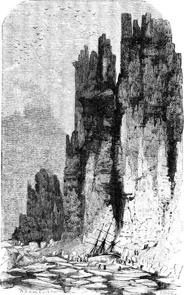
 SCENERY OF JAN MAYEN
Having completed a survey of the west coast of Spitzbergen, he resolved on sailing round the north end of Greenland, which he supposed to be an island, and returning to England by Davis Strait. With this view he again examined the sea between Spitzbergen and Greenland, but from the strong ice-blink along the northern horizon felt convinced that there was no passage in that direction. After sighting Spitzbergen, therefore, he determined to return to England; and on his homeward voyage discovered an island in lat. 71° N., which he named Hudson Sutches, and which has since been improperly named Jan Mayen. The Hopewell arrived in the Thames on the 15th of September.
The results of this voyage, says Mr. Markham, were very important, both in a geographical and a commercial point of view. Hudson had discovered a portion of the east coast of Greenland; he had examined the edge of the ice between Greenland and Spitzbergen twice—in June and in the end of July; and he had sailed to the northward of Spitzbergen until he was stopped by the ice, reaching almost as high a latitude as Scoresby in 1806, which was 81° 12′ 42″ N. Hudson’s highest latitude by observation was 80° 23’, but he sailed for two more days in a north-easterly direction. The practical consequence of his voyage was that his account of the quantities of whales and sea-horses in the Spitzbergen seas led to the establishment of a rich and prosperous fishery, which continued to flourish for two centuries.
In the following year Hudson made a second voyage, in the hope of discovering a north-eastern passage to China between Spitzbergen and Novaia Zemlaia. He exhibited his characteristic resolution, and forced his way to the very gate of the unknown region, which is still closed against human enterprise by an impenetrable barrier of ice; but all his efforts proved in vain, and he returned to Gravesend on the 26th of August.
In 1610, in a vessel of fifty-five tons, he once more entered the Polar seas, and gained the extreme point of Labrador, which he named Cape Wolstenholm. Here burst upon him the view of that magnificent sea which has since been associated with his name; and there can be no doubt that his enterprise would have anticipated the
discoveries of later navigators, but for the mutiny which broke out among his crew, and eventually led to his being sent adrift, with nine faithful companions, in a small open boat. He was never again heard of.
The spirit of commercial enterprise and the love of maritime adventure were still strong enough in England to induce the equipment of further expeditions. In 1612 sailed Captain Button,— who discovered a stream, and named it Nelson River; where, at a later date, the Hudson Bay Company planted their first settlement. Here he wintered. In April 1613, on the breaking up of the ice, he resumed his work of exploration, and discovered, in lat. 65°, an island group, which he named Manuel, now known as Mansfield, Islands. Then he bore away for England, arriving in the Thames early in September.
Robert Bylot and William Baffin undertook a voyage in 1615. The latter had had some previous experience of Arctic navigation, which he turned to advantage in 1616, when he accompanied Bylot on a second expedition. Their ship, the Discovery, of fifty-five tons, reached Cape Hope Sanderson, the furthest point attained by Davis, on the 30th of May; and after meeting with some obstruction from the ice, proceeded northwards to 72° 45’, where she dropped anchor for awhile among the Women’s Islands. Baffin kept to the north until he found ice in 74° 15’ N., and he then ascended Melville Bay, touching the head of the great basin now known by his name, and sailing down its western coast. He arrived in Dover Roads on the 30th of August, after a brilliantly successful voyage, which had opened up the principal north-west channels into the Arctic Sea.
It is necessary here to interpolate a few remarks in explanation of the difficulties which beset the Baffin Bay route of Arctic exploration.
Geographers assert, and the assertion seems confirmed by the experience of navigators, that a surface-current is constantly flowing down this bay, and carrying great fleets of icebergs and shoals of ice-floes into the Atlantic from its southern channels—Lancaster, Jones, and Smith Sounds. Hence, at the head of the bay there exists a considerable open and navigable expanse, which extends for some distance up Lancaster and Smith Sounds during the summer and early winter, and is known as the “North Water.” But between this open expanse and Davis Strait lies an immense mass of ice, averaging from one hundred and seventy to two hundred miles in width, and blocking up the centre of Baffin Bay, so as to interrupt the approach to the north-west end. This is known as the “middle pack,” and consists of some ancient floe-pieces of great thickness, which may have been brought down from a distant part of the Arctic seas; of a wide extent of ice accumulated during each winter, about six or eight feet in thickness; and of the grand and gigantic icebergs which are so characteristic a feature of the Melville Bay scenery. A very large quantity of this pack is destroyed in each succeeding summer by the thaws, or by the swell and warm temperature of the Atlantic as the ice drifts southward.
It is remarked of the Baffin Bay ice, that it is much lighter than that found in the Spitzbergen seas. The latter often occurs in single sheets, solid, transparent, and from twenty to thirty, and even forty, feet in thickness. In Baffin Bay the average thickness of the floes does not exceed five or six feet, and eight or ten feet is of very rare occurrence.
From Baffin’s voyage, in 1616, until 1817, no attempt was made to force this “middle pack” and enter the North Water; but now the voyage is made every year, and three routes have been opened up. The first is called the “North-about Passage,” and lies along the Greenland coast; the second, or “Middle Passage,” only possible late in the season, is by entering the drift-ice in the centre of the bay; and the third, or “Southern Passage,” also only possible late in the season, along the west side of Baffin Bay. Once in the North Water, whichever route be attempted, all obstacles to an exploration of the
unknown region may be considered at an end. From Cape York to Smith Sound the sea is always navigable in the summer months.
It will thus be seen that the great highways to the Pole were discovered by William Baffin.
Our limits compel us to pass over the voyages of Stephen Bennet (1603–1610), Jonas Poole (1610–1613), and Captain Luke Fox (1631). In 1631 the merchants of Bristol despatched Captain Thomas James, but he made no additions to the discoveries of his predecessors. And then for nearly two centuries England abandoned her efforts to open up a communication between the Atlantic and the Pacific.
In 1818, however, the question of the existence of a North-West Passage once more occupied the public mind; and the British Government accordingly fitted out an exploring expedition, the Isabella and the Alexander, under the command of Captain Ross and Lieutenant Parry.
They sailed from England on the 18th of April, reached the southern edge of the Baffin Bay ice on the 2nd of July, and, after a detention of thirty-eight days, reached the North Water on August 8th. The capes on each side of the mouth of Smith Sound, Ross named after his two ships; and having accomplished this much, he affirmed that he saw land against the horizon at a distance of eight leagues, and then retraced his course, and sailed for England.
The British Government, however, refused to be discouraged by the failure of an expedition which had obviously been conducted with an entire absence of vigour and enterprise. They therefore equipped the Hecla and the Griper, and gave the command to Lieutenant Parry; who sailed from the Thames on the 5th of May 1819, and on the 15th of June sighted Cape Farewell. Striking northward, up Davis Strait and Baffin Bay, he found himself checked by the ice-barrier in lat. 73° N. A man of dauntless resolution, he came to the determination of forcing a passage at all hazards; and in seven days, by the exercise of a strong will, great sagacity, and first-rate seamanship, he succeeded in carrying his ships through the pack of ice, which measured eighty miles in breadth.
He was then able to enter Sir James Lancaster Sound; and up this noble inlet he proceeded with a fair wind, hopeful of entering the great Polar Sea. But after advancing a considerable distance, he was once more met by the frozen powers of the North, and this time he was forced to own himself vanquished. He accordingly returned towards the south, discovering Barrow Strait; and, more to the westward, an inlet which has since figured conspicuously in Arctic voyages—Wellington Channel. Bathurst Island he also added to the map; and afterwards he came in sight of Melville Island. On the 4th of September he attained the meridian of 110° W long., and thus became entitled to the Parliamentary grant of £5000. A convenient harbour in the vicinity was named the “Bay of the Hecla and the Griper,” and here Lieutenant Parry resolved upon passing the winter.
In the following spring he resumed his adventurous course, and completed a very careful survey of the shores of Baffin Sea; after which he repaired to England, and reached the Thames in safety, with his crews in good health, and his ships in excellent condition, about the middle of November 1820.
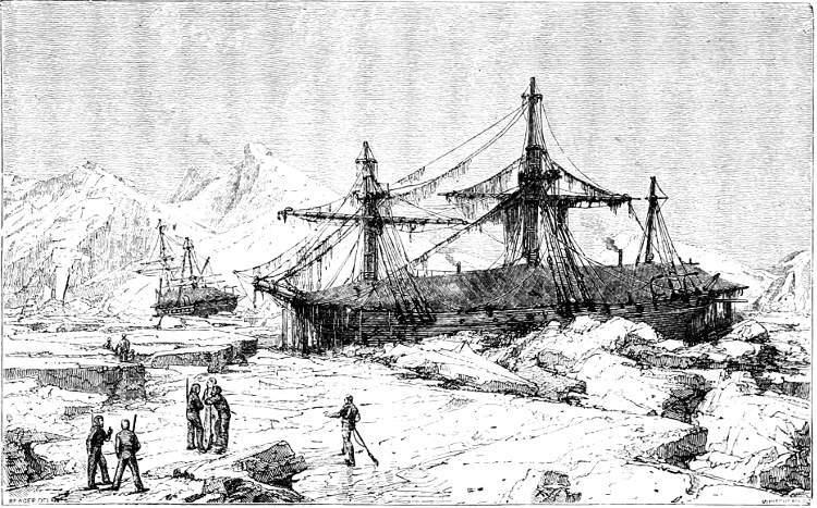 THE “HECLA” AND “FURY” WINTERING AT WINTER ISLAND
Having done so much and so well, it was natural that Captain Parry should again be selected for employment in the Arctic seas in the following year. He hoisted his flag in his old ship, the Hecla, and was accompanied by the Fury; both vessels being equipped in the most liberal manner. He sailed from the Nore on the 8th of May 1821; he returned to the Shetland Islands on the 10th of October 1823. In the interval, a period of seven-and-twenty months, he discovered the Duke of York Bay, the numerous inlets which break up the northern coast-line of the American continent, Winter Island, the islands of Anatoak and Ooght, the Strait of the Fury and Hecla, Melville Peninsula, and Cockburn Island. During their winter sojourn on Winter Island, the English crews were surprised by a visit from a party of Eskimos, whose settlement Captain Parry visited in his turn. He found it an establishment of five huts, with canoes, sledges, dogs, and above sixty men, women, and children, as regularly, and, to all appearance, as permanently fixed as if they had occupied the same spot the whole winter. “If the first view,” says Parry, “of the exterior of this little village was such as to create astonishment, that feeling was in no small degree heightened on accepting the invitation soon given us to enter these extraordinary houses, in the construction of which we observed that not a single material was used but snow and ice. After creeping through two low passages, having each its arched doorway, we came to a small circular apartment, of which the roof was a perfect arched dome. From this three doorways, also arched, and of larger dimensions than the outward ones, led into as many inhabited apartments—one on each side, and the other facing us as we entered. The interior of these presented a scene no less novel than interesting: the women were seated on the beds at the sides of the huts, each having her little fireplace or lamp, with all her domestic utensils about her. The children crept behind their mothers, and the dogs shrank past us in dismay. The construction of this inhabited part of the hut was similar to that of the outer apartment,—being a dome, formed by separate blocks of snow laid with great regularity and no small art, each being cut into the shape requisite to form a substantial arch, from seven to eight feet high in the centre, and having no support whatever but what this principle of building supplies. Sufficient light was admitted
into these curious edifices by a circular window of ice, neatly fitted into the roof of each apartment.”
In 1824–25 Captain Parry undertook a third voyage, but with less than his usual success. The Fury was driven ashore by the pressure of the pack-ice, and so damaged, that Parry found it needful to abandon her, and remove her crew and stores to the Hecla.
Sir John Parry’s fourth and last expedition, in 1827, was characterized by his bold attempt to cross the icy sea in light boats
THE “FURY” ABANDONED BY PARRY—1824.and sledges; resorting to the former when his progress was interrupted by pools of water, and to the latter in traversing the unbroken surface of the ice-fields. He was soon compelled, however, to abandon the sledges, on account of the hummocks and irregularities of the ice.
We agree with Mr. Cooley, that voluntarily to undertake the toil and brave the danger of such an expedition, required a zeal little short of enthusiasm. When the travellers reached a water-way, they were obliged to launch their boats and embark. On reaching the opposite side, their boats were then to be dragged, frequently up steep and perilous cliffs, their lading being first removed. By this laborious process, persevered in with little intermission, they contrived to accomplish eight miles in five days. They travelled only during the night, by which means they were less incommoded with snow-blindness; they found the ice more firm and consistent; and had the great advantage of lying down to sleep during the warmer portion of the twenty-four hours. Shortly after sunset they took their breakfast; then they laboured for a few hours before taking their principal meal. A little after midnight, towards sunrise, they halted as if for the night, smoked their pipes, looked over the icy desert in the direction in which the journey was to be resumed; and then, wrapping themselves in their furs, lay down to rest. Advancing as far north as 82° 40’, they were then compelled by the drifting of the snow-fields to retrace their steps. They regained their ships on the 21st of August, and sailed for England.
We must now go back a few years. In May 1819, an overland expedition was despatched to ascertain the exact position of the Coppermine River, to descend it to its mouth, and to explore the coast of the Arctic Sea on either hand. The command was given to Lieutenant Franklin, who was accompanied by Dr. Richardson the naturalist, by Messrs. Hood and Back, two English midshipmen, and two picked seamen. The expedition was spread over a period of two years and a half, and the narrative of what was accomplished and