
Gallants Channel Master Plan Update
“A Place for Everyone, by the Sea”

North Carolina Maritime Museum
Gallants Channel Master Plan Update
Prepared by Clark Nexsen Ann Beha Associates Stewart Engineering Biohabits
“A Place for Everyone, by the Sea”


CONTENTS PREFACE PROCESS AND ENGAGEMENT THE MASTER PLAN GUIDING PRINCIPLES DISCOVER AND UNDERSTAND EXPLORE REFINE AND EXECUTE PROGRAM ELEMENTS APPENDIX 2 4 6 6 8 20 26 38 62 1
PREFACE
The North Carolina Maritime Museum Master Plan for the Gallants Channel Campus aligns with the mission and vision to convey maritime history and the correlated natural history to future generations by establishing a framework for development that guides future decision making through the values and priorities articulated in the master plan. The implementation strategy that is put forward reflects these values and priorities and seeks to leverage the resources available in the near term to have the greatest impact with activation the site in Phase I and setting the foundation for continued investment in the future as additional funding becomes available.

Mission Statement
“The North Carolina Maritime Museum documents, collects, and preserves the maritime history – and its correlated natural history – of coastal North Carolina for the purpose of interpreting this history through its educational services and exhibits for our contemporary society and passing intact its material culture to future generations.”
2
Executive Summary
The Gallants Channel site consists of a large tract owned by the State of North Carolina. The vision for the site is to expand The North Carolina Maritime Museum’s (NCMM) capacity for educational programs related to all aspects of North Carolina’s maritime heritage, past and present, along with development of partnerships with the marine research facilities in Carteret County.
The Masterplan builds upon previous studies of the past 20 years provided to Clark Nexsen by the Foundation in order to create a layout illustrating the location of the expanded NCMM and the Maritime Education Center (MEC) along with additional potential site features and uses.
Clark Nexsen, Ann Beha Architects, and Stewart Engineering make up the core of the design team. Clark Nexsen is leading the Masterplan project team. Ann Beha Architects is providing specialty planning expertise related to cultural campus development, specifically maritime museums. We are collaborating with Stewart Engineering, who is leading the site analysis of the 31 acre parcel and will facilitate engagement and documentation with key regulatory agencies impacting site development such as NCDOT and CAMA.
Our core team is augmented by the following sub-consultants:
Cost Estimating: Cost Services Group
Coastal Ecology : Biohabitats – Coastal Ecology
The design team will complete this work in three phases, the goals of each outlined as follows:
Phase I – Discover and Understand
The master planning begins with a process of discovery through data collection and analysis. This understanding of current conditions includes examination of natural and human-built systems as well as a comprehensive review of all previous studies to articulating the vision and aspirations for the masterplan. Working with the Masterplan Leadership Group, a Vision and draft of guiding principles, and priorities for the state will be established to begin to test alternative concepts for the organization and development of the Gallants Channel Campus.
Phase II – Explore
Based on the consensus direction from Phase I, the masterplan is finalized through refinement of design, cost models and phasing strategies that provide a map for implementation. A presentation will be made to the Masterplan Leadership Group for approval in advance of final submission of the completed masterplan.
Phase III – Refine and Execute
3
PROCESS AND ENGAGEMENT
A three-phase process guided the development of the master plan: Discover and Understand, Explore, and Refine and Execute. The initial Discovery phase gathered both qualitative and quantitative data on the site as well as a review of previous study documents review to inform site analysis drawings to guide the Engagement and exploration of alternative approaches for the future development of Gallants Channel. These first two phases then formed the basis of a development roadmap for phasing investments in site development over the next 20 years.
4
Phase 1 - Discover and Understand
The master planning begins with a process of discovery through data collection and analysis. This understanding of current conditions includes examination of natural and human built systems as well as community and stakeholder outreach necessary to articulating the vision and aspirations for the master plan.
Phase 2 - Explore
Working with the Master Planning Leadership team and key stakeholders, a Vision and draft of guiding principles are established to begin to test alternative concepts for the organization and development of the Gallants Channel Campus. Interactive workshops provide opportunities for exploring alternative strategies, testing, and validating opportunities to establish project site priorities.
Phase 3 - Refine and Execute
Based on the consensus direction from phase 2, the master plan is finalized through refinement of design, cost models and phasing strategies that provide a map for implementation. Presentations were made the Master Planning Leadership team and key stakeholders for approvals in advance of final submission of the completed master plan.
5
THE MASTER PLAN
GUIDING PRINCIPLES
• The North Carolina Maritime Museum at Gallants Channel will be a premier cultural center and an internationally recognized maritime center.
• The North Carolina Maritime Museum at Gallants Channel will be a collection of memorable spaces.
• The North Carolina Maritime Museum at Gallants Channel is a community of communities.
• The North Carolina Maritime Museum at Gallants Channel is a citizen of Beaufort, Morehead City, down east communities, the region and the state.
– Engage with surrounding neighbors and community
– Create a plan that promotes stewardship of the museum’s land and buildings.
• The North Carolina Maritime Musem at Gallants Channel will establish a vision for sustainability and resiliency appropriate for a coastal setting in the 21st century.
6
Vision Statement
Create a destination experience that deepens the understanding of maritime history, culture and environment within the context of the Beaufort community, the State of North Carolina, and along the southeastern seaboard.


Vision and Goals
1. Create an outdoor living room for North Carolina 2. Celebrate the significance and value of water 3. Create a diversity of outdoor spaces that are responsive to different needs and activities 4. Create Indoor/Outdoor Hybrid Spaces 5. Include a diversity of building scale and form 6. Provide visual interest 7. Plan for flexibility of indoor and outdoor spaces 8. Be responsive to human scale 9. Be a model of environmentally responsive building in a coastal environment 10. Accommodate current and future outdoor events 11. Offer something for everyone 12. Create a framework for future buildings, landscape, and activities
7


DISCOVER AND UNDERSTAND
Menhaden Factory Fishermen
8
Fish Meal Company - 1947. Formerly Located on the Gallants Channel Site
The Land | Human and Natural History
The Gallant’s Channel Site’s in Beaufort was acquired by the North Carolina Maritime Museum, a division of the North Carolina Department of Cultural Resources with the intent to develop the property as a natural and historic resource center to preserve and interpret the unique maritime heritage and coastal ecology of North Carolina.
The site is found at the western edge of Beaufort’s city limits and is approximately one mile from the core of downtown and located on historic Gallant’s Channel to the West. Gallants Channel is not only a part of the Intercoastal Waterway but along with the surrounding waterways also an integral part of North Carolina and U.S maritime history. Laid out as a colonial seaport in 1713, Beaufort is North Carolina’s third oldest town and home port for shore-based whaling at Cape Lookout and Shackleford Banks. The town served as a U.S. Customs port in the eighteenth century.
The long leaf pine covering eastern North Carolina provided a boundless supply of tar, pitch and turpentine that led to North Carolina becoming the leading exporter of naval stores and earned the designation as the ”Tar Heel” state. The long history of commercial maritime traffic served by Gallants Channel supported boat building, oyster canneries and fish houses lining the banks of the local waterways in the nineteenth and early twentieth century.
9


DISCOVER AND UNDERSTAND 10
During the initial phase of seeking to understand the site and discover design opportunities for future development, the inherent potential in the land itself to inform the master plan framework was quickly revealed. The site’s strategic location, reflection of the range of natural environments unique to the region and historical significance to North Carolina’s maritime story are all important threads in weaving together the fabric of the final master plan.
4 Landscapes • Gateway/Entry • MaritimeForest • Shoreline(EudyMarsh)
TheLawn
The
•
11

DISCOVER AND UNDERSTAND 12
Gateway / Entry
The Master Plan proposes a new entry sequence to welcome visitors to the North Carolina Maritime Museum at Gallant’s Channel. Adjacency to the recently completed US 70 and Town Creek bridges, provide direct access to the site from a major transportation artery and the entry threshold to historic Beaufort NC. As the intensity of access to the site increases with future development, the opportunity exists to strengthen these connections and provide improved safety of access for multiple modes of transportation. Through discussions with Michael J. Smith (KMRH) Airport, several opportunities exist for improving access for both KMRH and the NC Maritime Musuem. As part of the museum site development, the potential for access to the western part of the airfield between runways 3 and 8 would enhance the opportunity for future development adjacent to these runways. The exploration of access from the existing signaled intersection of US 70 and Turner Street could provide improved site access with modest adjustments to the existing taxiway to runway 3/21. This runway has an existing displaced landing threshold for approaches from southwest. This access point also provides the potential for connection to a potential future pedestrian / bikeway that follows the path of the rail path that served the Menhaden factory previously occupying the site. The signal at this intersection also provides a second potential future pedestrian / bikeway access along the southern edge of US 70 and grade separated access to the site near the current sailing school docks.

13

DISCOVER AND UNDERSTAND 14
Maritime Forest
The Northern and Eastern boundaries of the site is home to maritime forest and wetlands that contain trees and shrubs that connect to the state’s maritime history including Live Oak, Red Cedar, and Atlantic White Cedar Juniper that are all part of the traditional boat building woods utilized since the sixteenth century in North Carolina boat construction. Carolina Willow, Red Mulberry, and Silver Poplar also grow on the site as do Mimosa, Wild Cherry, Yaupon Holly, Purple Muhly, Medow Hay, Pennywort and Goldenrod. The recent addition of nature trails on the site is preserved in the Master Plan and provides the opportunity to interpret the historic flora and habitat of the region to the public and build knowledge of the fragility of the coastal ecology. Future development of the trails can serve to extend the NC maritime story into the surrounding landscape through outdoor exhibits illustrating the connection between boatbuilding and the forest, the importance of storm water features and wetland buffers as part of the regional ecosystem, and the maritime forest provides habitat for native birds like the Painted Bunting.

15

DISCOVER AND UNDERSTAND 16
Shoreline (Eudy Marsh)

The Shoreline of the Gallant’s Channel site is the focal point of the Master Plan. The placement of proposed structures on the site is intentionally designed to maximize on site view sheds to the shoreline and the Eudy Marsh beyond, extending the visitor experience beyond the land’s edge to the water. The diversity of maritime activity along Gallant’s Channel not only connects directly to the mission of the museum but also serves to animates this edge of the site.
One of the initial investments by the state of North Carolina in the Gallants Channel site was the dock structures that played host to the Pepsi America Tall Ships event in 2006. The development of the water’s edge has continued with the recent addition of the sailing school and rowing docks at the southern edge of the site. The Master Plan embraces the opportunity for the shoreline to serve the museum’s mission with an active working waterfront that can continue to accommodate a wide variety of maritime vessels from historic ships to active maritime research vessels. Active engagement of the shoreline extends to the possibility of providing visitors the opportunity to experience the surrounding waters of the region through a water taxi or ferry service.

The NC Maritime Museums’ Junior Sailing Program is located at the southernmost edge of the site. In addition to the recent construction of docks, the Master Plan includes a boat launch ramp that will provide additional access to the water.

17


DISCOVER
UNDERSTAND 18
AND
The Lawn
The Lawn is the centerpiece and heart of the Master Plan. The concept of the lawn builds on the emergence of the site as one the region’s most popular destinations for hosting large outdoor events in the community like the annual Beaufort Music Festival and Pirate Invasion.

The geometry, orientation and topography of the sloping Lawn and location of the performance area at the water’s edge is ideal as an amphitheater to host the community and visitors for outdoor group events ranging from the current concerts and music festivals to movie screenings and large community celebrations like the 4th of July fireworks and maritime events on the waterfront. The Lawn provides a Community Commons to not only support these scheduled events but also as a casual gathering place for outdoor activities with views to the water’s edge and Eudy Marsh beyond.
The Lawn also serves an important environmental function, providing a large area of pervious surface to strategically address issues of stormwater management, including absorbing storm surge and flooding.
19
EXPLORE 20


21

22
Shoreline

23

24
Design Option 1


Design
Design Option 3 25
Option 2
REFINE AND EXECUTE | Organizational Concept
The core planning principles identified during the Discovery Phase have informed the final Master Plan framework and will provide guidance in shaping the next steps in transforming the site’s future building design and construction. Responding to the inherent potential of the site that has been articulated in the Four Landscapes along with the Vision and Guiding Principles the organizational concept of the Master Plan weaves together the opportunities and aspirations for Gallant’s Channel into specific site and architectural planning concepts.

26


27
The final master plan builds on the inherent potential of the site as identified in the Discover and Explore phase of devzzelopment. The idea of creating a new Gateway to the site begins with the approach from the intersection of Turner Street and arrival on site at the edge of the southern portion of the Maritime Forest. This arrival threshold establishes the identity of the NC Maritime Museum with placement of the Coast Guard Cutter 44’ Motor Life Boat Display. The Cutter provides a visual icon to announce the entry rather than relying on simply signage and is the first element in the choreography of the arrival sequence. As the visitor approaches the heart of the campus, the Lawn serves as a central organizing element to orient and connect visitors to the major elements of the site. The Lawn also serves to orient and connect visitors that are arriving from the water at the western edge of the lawn.
The sequence of visitors moving along the eastern edge of the Lawn provides views of the water’s edge and the Lawn is framed by the two major program elements, the Maritime Education Center on the southern Edge and the future Maritime Museum on the northern edge, as a primary view along the approach road. The bosque of trees at the museum entry not only serves to integrate landscape into the arrival sequence but also provides a opportunity as a memorial garden. The porch opposite the bo of trees provides protected drop off for visitors arriving by car and bus. Visitors may also proceed directly to a new parking area at the northern edge of the site, passing alongside the 18th century Ward Hancock House. The House also serves as an important element in the pedestrian entry sequence and has been relocated to a higher elevation on the site and

28
restored to its original orientation. This parking area also makes what already exists more accessible by offering visitors the opportunity to access the nature trails that are woven into this edge of the site, connecting to the waterfront as well as to naturals areas to the east of the site.
For those visitors to the Maritime Education Center (MEC), the entry sequence also provides direct access to parking along the southern edge of the Lawn. The parking area is integrated into the existing wooded area and around the wetlands noted in the area. In addition to providing proximity to the MEC and a drop off area, the drive also connects to the gravel road that provides access to the Junior Sailing School docks and future boat launches.


29

30

31

32
The Maritime Forest provides a buffer to residential development to the North and the airport to the East. As noted above, visitors may choose to access the museum from the canopy adjacent to the parking area following the network of pathways that provide an alternative path to the water’s edge through the Maritime Forest. This natural area provides opportunity for moments of learning and exploration and experiencing the native landscape and biodiversity of the region.


33


34
The Lawn: Connecting to Place and a Place to Connect. As noted earlier, The Lawn is envisioned as the Heart of Gallant’s Channel. The Lawn encourages people to gather by the water for learning, play, entertainment or simply connecting in a more visceral way with the natural surroundings of Gallant’s Channel and Eudy Marsh. The orientation takes advantage of the area of the site which had previously been cleared and is oriented to the Southwest, responding to the micro-climate by opening the site to the prevailing winds. The porches of the adjoining structures take advantage of these prevailing winds by providing protection from the summer sun and orienting outdoor areas to the viewsheds of the water. The lawn provides an opportunity to gather, moments of prospect and overlook and a central place for visitor orientation. At places along the lawn extended vistas and focal points are possible and visibility between site elements is fostered. The “porch” of each of these buildings provides a porous edge to the lawn museum signaling the building entry.


35


36
By land and by Sea The Shoreline as noted earlier provides viewsheds to the water and the Eudy Marsh beyond. The interface with the water’s edge provides for engagement and learning as Beacon, Immerse, Engage and Learn.

37
PROGRAM ELEMENTS


38
Maritime Museum + Maritime Education Center
The concept for the Maritime Museum and MEC is to frame the Lawn with the buildings oriented to provide a porous edge, connecting indoors with outdoors through a series of porches and cascading stairs. The Porch is a significant cultural historical architectural element in Beaufort and a vehicle for hybrid spaces that connect inside to outside. The porch provides covered and protected areas adjacent to both Lawn and building, maximizing the Inside-Outside-Edge experience. These In-between spaces are landscape rich and invite people beyond the traditional “museum’ experience. The use of these “mid-door” spaces between buildings connect people to maritime places of the site and have a considerably longer useful season as well as a greater range of uses. Shutters, louvres, sliding doors and screens adapt such spaces to the exact needs of the use at different times. These spaces create opportunities for protected movement and provide shade on hot, sunny days. They also promote sociability by providing comfortable places to engage with others, sitting on a bench or the cascading steps overlooking the lawn.

39

40
Maritime Museum
The future museum anticipated to be more than 80,000 square feet represent a diversity of building scale. The master plan strategy is to compose the buildings as a series of connected smaller scale buildings with similar roof forms and porch edges that serve to mitigate the scale of the larger building by creating a composition of more modest scaled connected buildings. The architectural approach draws inspiration from vernacular forms as well as the humble industrial shed buildings that once occupied the site serving the menhaden fishing industry. These buildings were constructed with natural ventilation, access to daylighting and to provide large open floor areas providing openness and flexibility. The final detailed program for the future North Carolina Maritime Museum at Gallant’s Channel will be defined in the next phase of project development but is expected to include space for:
• Welcome Center and Orientation
• Retail Shop
• Waterfront Promenade
• Exhibit Spaces - Exhibit Halls - Childrens Learning Center - Maritime History - Conservation Exhibits and Laboratory
• Auditorium
• Large flexible space for museum presentations with connection to outdoors areas for prefunction and events.
• Administrative Offices
• Support Spaces for Maintenance and Fabrication
41


42
Maritime Education Center
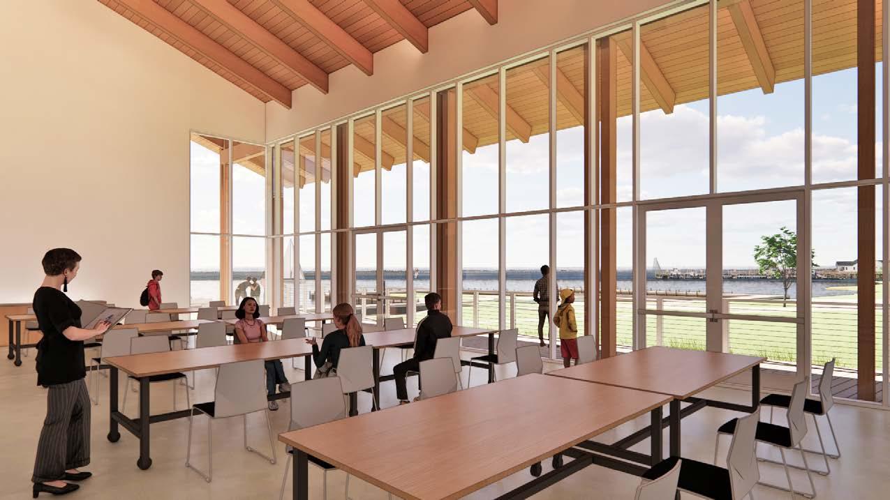
The MEC building of approximately 8,500 square feet and represents the primary building of the Phase I implementation of the master plan. The building anchors the southwestern edge of the Lawn and is oriented to visually connect with both the Lawn and the water’s edge and Eudy Marsh beyond. As the visitor approaches the MEC, the pitched metal roof forms and natural wood material palate are understated and familiar to the region. The approach along the path forming the edge of the Lawn gradually ramps up and connects to an elevated boardwalk. The framed timber and exposed rafters lift one’s view up and out, with uninterrupted vistas of the water and passing maritime traffic of Gallant’s Channel. The large interior classrooms connect visually and physically to the large surrounding porch. The program for the MEC includes:
• Classrooms with flexibility for configuring as two 50 seat classroom or combined as a one large event and presentation space.
• Library to provide access to collections and support small meetings
• Administrative Offices and Conference Spaces
• Bathroom and shower facilities for supporting the classroom, offices, sailing program participants and visitors to the site.
• Ticketing, exhibit, office and storage space for potential use by a partner providing water taxi or ferry service on site.
Additional Building Program Elements:
• A one-acre site for a future Animal Rescue and Rehabilitation Center has been designated for the eastern edge of the site adjacent to the airport. The site will accommodate a building of approximately 10,000 square feet, associated parking for 10 staff, a 500 square feet storage building and outdoor space for Pinniped and Saltwater storage tanks associated with the center’s operations. The center will occasionally use the waterfront docks for transporting rescued animals to the facility.
• • •
The Historic Ward Hancock House which was relocated to the Gallant’s Channel site is proposed to be relocated to a site adjacent to the future museum entry. This site provides greater visibility and access for visitors and placement in a more historically accurate orientation to the Southwest.
A small-scale housing area is provided at the northern edge of the site adjacent to the Maritime Forest and adjoining residential area. The housing is intended to support short term visitors collaborating with and supporting the museum’s programs.
A small maintenance building to support the boat maintenance as well as provisions for storage of site maintenance equipment are provided on site adjacent to the US 70 bridge and sailing docks at the southern edge of the stie.
43

44

45

46

47

48

49

50

51
52

53

54

55

56

57

58

59
60


61
!"#$%&!'(('#)*$
,($-).)/'(0&1"%#&2%#).'#$&3"(&4)(%#&45/6$6&,7'%$& '#&8'--'/#%&17'//$-
2%#).'#$&H'#$+ JI&S'(;7&NINN B0+
!"#$%+
2%#).'#)/@&,(';#);$%+&1"%#)/@&F$(*);$%&8("59E&O/;A&3"--"?%&%#();#&D5)6$-)/$%&3"(&'--&D5'/#)#0& #'>$P"33&6$%;()B$6&)/$&Q#7&26)#)"/&F#'/6'(6&2%#).'#)/@&,(';#);$&95B-)%7$6&B0$& R.$();'/&F";)$#0&"3&,("3$%%)"/'-&2%#).'#"(%&<RF,2=A

,5(9"%$&'/6&5%$&"3&$%#).'#$+&:7)%&$%#).'#$&)%&)/#$/6$6&#"&($3-$;#$&3')(&<"9$/=&.'(>$#& *'-5$&3"($&%;"9$&"3&?"(>&6$3)/$6&)/$&6$%)@/&6";5.$/#%A&&:7$&$%#).'#$&'%%5.$%& ($;$)*)/@&B)6%&3(".&'&.)/).5.&"3&<C=&D5'-)3)$6&@$/$('-&;"/#(';#"(%A&&:7$&$%#).'#$&)%&'/& "9)/)"/&"3&9("B'B-$&;"%#&'/6&)%&9("*)6$6&'%&'&#""-&3"($&6$%)@/&#$'.&'/6&"?/$(&#"&5%$&)/& .'>)/@&6$%)@/&6$;)%)"/%&($-'#)/@&#"&;"%#A&&:7$&$%#).'#"(&;'//"#&'/6&6"$%&/"#&@5'('/#$$& #7'#&B)6%E&9("9"%'-%&"(&';#5'-&;"/%#(5;#)"/&;"%#%&?)--&/"#&*'(0&3(".&'/0&$%#).'#$&"(&%#560A&&
H$%)@/&H('?)/@%&H'#$6+&IJKLMKNINN F9$;)3);'#)"/%K!'(('#)*$&H'#$6+&IJKLMKNINN
!"#$#%&'()&#$*+%&$'%$#%*),)&#-$&+$&"#$-)&#$%&)&#-$+.$&"#$/0(()12$3)4#$+5$&"#$ #%&'()&#%6$$!"'%$#%&'()&#$'%$.+&$'.&#.-#-$&+$1#5,#*&$*+.%&10*&'+.$*+%&%$7#2+.-$&"#$ #%*),)&#-$&+$-) F;"9$&"3&?"(>+&:7$&-)/$&)#$.%&)/;-56$6&)/$&$%#).'#$&($9($%$/#$&$%#).'#"(%& 5/6$(%#'/6)/@&"3$&%;"9$&"3&?"(>&'%&;"..5/);'#$6&B0$&6";5.$/#%&)6$/#)3)$6&)/$& B'%)%&"3&$%#).'#$&B$-"?A& G'%)%&"3&2%#).'#$+
APPENDIX 62
,();)/@&G'%)%+ F;"9$K,();)/@+
!$?&1"/%#(5;#)"/
15(($/#&,($*')-)/@&e'@$&f'B"(&g'#$% ,(";5($.$/#&S$#7"6+&1".9$#)#)*$&G)6&<.)/A&"3&<C=&D5'-)3)$6&-";'-&B)66$(%&3"(&9().$&;"/#(';#= R6$D5'#$&F5B;"/#(';#"(&1"*$('@$ !"(.'-&e"(>)/@&Z"5(%
:7)%&6";5.$/#&)%&'/&$%#).'#$&"3&9("B'B-$&;"/%#(5;#)"/&;"%#&"3"%$&;".9"/$/#%&/"(.'--0& )/;-56$6&?)#7)/$&7'(6&;"/%#(5;#)"/&B56@$#A&2%#).'#)"/&"3&"#7$(&6)%;)9-)/$%&'/6&9("_$;#& ;"%#%E&)/;-56)/@$&3"--"?)/@E&)%&$X;-56$6A
O#$.%&.'(>$6&`442`E&`!O1`&"(&%9$;)3);'--0&$X;-56$6&?)#7)/$&$%#).'#$&6$#')-&)/6);'#$6& ?)#7&'&`I`&D5'/#)#0
,("_$;#&a%"3#&;"%#%b&)/;-56)/@&V?/$(&9("_$;#&'6.)/)%#('#)"/E&H$%)@/&<RK2=&'/6&($-'#$6& 1"/%5-#)/@&3$$%
1"/%#(5;#)"/&'6.)/)%#('#)"/&;"%#%E&'/6K"(&"?/$(c%&($9($%$/#'#)*$&3$$% ,($.)5.%&'%%";)'#$6&?)#7&dRE&.)/"()#0K6)%'6*'/#'@$6&B5%)/$%%E&$#;AE&)3&.'/6'#$6
!"#$%&!'(('#)*$ TKPCECIIF4 8$/$('-&1"/6)#)"/%+LCU V*$(7$'6&W&,("3)# CU H$%)@/&1"/#)/@$/;0+LCU 2%;'-'#)"/&1"/#)/@$/;0+LNU F;7$65-$+ 8$/$('-&2X;-5%)"/%+ :7$&3"--"?)/@&'($&$X;-56$6&3(".$&$%#).'#$+ S$6);'-&%9$;)'-#)$% F0%#$.&6$*$-"9.$/#&;7'(@$%E&5#)-)#0&;".9'/0&%5(;7'(@$%E&"(&).9';#&3$$% F9$;)'-&)/%9$;#)"/%E&@$"#$;7/);'-&($9"(#%E&"(&"?/$(Y%&;"/#)/@$/;0 Z'['(6"5%&.'#$()'-&'B'#$.$/# 45(/)#5($&W&35(/)%7)/@%\&F0%#$.%&35(/)#5($ N]K^&%$;5()#0&@5'(6&65()/@&;"/%#(5;#)"/
:$-$K6'#'&7$'6P$/6 S'(>59%&3"(&1"/#)/@$/;)$%E&8$/$('-&1"/6)#)"/%E&1"/#(';#"(&4$$&'($&)/;-56$6&'%&3"--"?%+
63
,("_$;#+&G$'3"(#&S'()#).$&S5%$5. ,7'%$+&1"/;$9# ,("_$;#&!"A+&NNIJN 2%#).'#$&H'#$+&JI&S'(;7&NINN R(;7)#$;#+&1-'(>&!$X%$/ g$*)%)"/&H'#$+
FjSSRgk l2k1VS,V!2!:&H2F1gO,:OV! 2F:OSR:2
]KLCKNN&&LI+]d&RS 2h,R!H2H&1VS,V!2!:&2F:OSR:2 ,'@$&J
R#-'/#'E&8$"(@)'
LN^I&eA&,$';7#($$&F#AE&F5)#$&J1VF:O!8&F2giO12F&8gVj,E&O!1A
V,:OV!&L&P&S21&GjOfHO!8&P&L&F:Vgk
V,:OV!&N&P&S21&GjOfHO!8&P&N&F:Vgk
FO:2&V,:OV!F
64
mJECICE]Jd
mJE^]^EJQM
m]EQ]JENMN
,("_$;#+&G$'3"(#&S'()#).$&S5%$5. ,7'%$+&1"/;$9# ,("_$;#&!"A+&NNIJN 2%#).'#$&H'#$+&JI&S'(;7&NINN R(;7)#$;#+&1-'(>&!$X%$/ g$*)%)"/&H'#$+ V,:OV!&L&P&S21&GjOfHO!8&P&L&F:Vgk l2k1VS,V!2!:&H2F1gO,:OV! 2F:OSR:21VF:KF4
LJ^ELIINCAII 22h:2gOVg&eRff&FkF:2S LNMELJNNJAII 42h:2gOVg&HVVgF&R!H&V,2!O!8F JNQEI]IMIAII 8O!:2gOVg&HVVgF&R!H&V,2!O!8F LJLEMLMN]AII ZO!:2gOVg&,Rg:O:OV!F ^ME^^ML]AII OeRff&4O!OFZ2F ^ME^^ML]AII n4fVVg&4O!OFZ2F&R!H&GRF2 C]Ed]ILIAII l12OfO!8F&R!H&FV44O:F C]Ed]ILIAII fF:ROgF&R!H&gROfO!8F NE^]N IACI SR112FFVgO2F&R!H&F,21ORf:O2F LME]CN JAII !4Oh2H&2ojO,S2!: I IAII V1RF2eVgl&R!H&SOffeVgl ]LELJI ^ACI ,fVVF2&2ojO,S2!:&R!H&4jg!OFZO!8F LIEQMd NAII oS21ZR!O1Rf&1V!i2kR!12F I IAII g,VVfF&W&4Vj!:RO!F I IAII FeRF:2&eR:2g&HOF,VFRf&R!H&:g2R:S2!: I IAII :,fjSGO!8 NIdEJQNJdAII j4Og2&,gV:21:OV! JdEJdd ^AII iZiR1&FkF:2S LQLEQ]IJCAII e2f21:gO1Rf&,Ve2g LIQEMdINIAII hfO8Z:O!8 LIQEMdINIAII kF,21ORf&FkF:2SF&R!H&1VSSj!O1R:OV!F dNENMILCAII pFO:2&H2i2fV,S2!: I IAII RRFO:2&j:OfO:O2F I IAII GGH2SVfO:OV! I IAII
]KLCKNN&&LI+]d&RS
,'@$&]
R#-'/#'E&8$"(@)'
GjOfHO!8&1VS,V!2!:&2F:OSR:2&FjSSRgk R($'+CE]d]F4 R82!2gRf&1V!HO:OV!F&R!H&1V!:gR1:Vg&422&<LCU&81E&CU&4$$= m]M^EMdQmdCANd GGjOfHO!8&4Vj!HR:OV!F&R!H&FfRG&V!&8gRH2 LCJECCNNdAII 1F:gj1:jgRf&FkF:2S JILEMNICCAII HgVV4O!8&FkF:2S
F5B#"#'- mNE^NLEMLJm]QMANd H2:ROf2H&H2FO8!&K&SRgl2:&1V!HO:OV!F&1V!:O!82!1k LCU]IdEN]N^]A]] !"#$%$&'()#*+,"-),.#*()#+,(/()011234(5677819 :;<=>?<@AA:ABCDB> 2%;'-'#)"/ LNUmJ^CECdJ mMd !"#$%$&'()#*+,"-),.#*()#+,(/('9E87842F :;<ACA<G;@:H;?D>= 2%#).'#$&'%%5.$%&($;$)*)/@&B)6%&3(".&'&.).).5.&"3&<C=&D5'-)3)$6&@$/$('-&;"/#(';#"(%&P&V9$/&G)6 65
2h,R!H2H&1VS,V!2!:&2F:OSR:2
LN^I&eA&,$';7#($$&F#AE&F5)#$&J 1VF:O!8&F2giO12F&8gVj,E&O!1A
,("_$;#+&G$'3"(#&S'()#).$&S5%$5. ,7'%$+&1"/;$9# ,("_$;#&!"A+&NNIJN 2%#).'#$&H'#$+&JI&S'(;7&NINN R(;7)#$;#+&1-'(>&!$X%$/ g$*)%)"/&H'#$+ V,:OV!&N&P&S21&GjOfHO!8&P&N&F:Vgk l2k1VS,V!2!:&H2F1gO,:OV! 2F:OSR:21VF:KF4
CEdd]F4
]KLCKNN&&LI+]d&RS
,'@$&C
GjOfHO!8&1VS,V!2!:&2F:OSR:2&FjSSRgk R($'+
R82!2gRf&1V!HO:OV!F&R!H&1V!:gR1:Vg&422&<LCU&81E&CU&4$$= m]QQEQ^Lmd]AQ^ GGjOfHO!8&4Vj!HR:OV!F&R!H&FfRG&V!&8gRH2 LCNEQd]NMAII
2h,R!H2H&1VS,V!2!:&2F:OSR:2 F5B#"#'- mNEQIQE]MQm]Q]A]^ H2:ROf2H&H2FO8!&K&SRgl2:&1V!HO:OV!F&1V!:O!82!1k LCU]JME]NI^]AL^ !"#$%$&'()#*+,"-),.#*()#+,(/()011234(5677819 :;<;GA<@@?:AH@DHG 2%;'-'#)"/ LNUm]ILECI^ mMd !"#$%$&'()#*+,"-),.#*()#+,(/('9E87842F :;<BGB<;?H:H;HD@@ 2%#).'#$&'%%5.$%&($;$)*)/@&B)6%&3(".&'&.).).5.&"3&<C=&D5'-)3)$6&@$/$('-&;"/#(';#"(%&P&V9$/&G)6 66
LN^I&eA&,$';7#($$&F#AE&F5)#$&J 1VF:O!8&F2giO12F&8gVj,E&O!1A R#-'/#'E&8$"(@)'
1F:gj1:jgRf&FkF:2S NQ]ENIICIAII HgVV4O!8&FkF:2S
LICEQLNLdAII 22h:2gOVg&eRff&FkF:2S L]LENLMN]AII 42h:2gOVg&HVVgF&R!H&V,2!O!8F NQ]ENIICIAII 8O!:2gOVg&HVVgF&R!H&V,2!O!8F LJCEJJNNJAII ZO!:2gOVg&,Rg:O:OV!F ^JECCILNACI OeRff&4O!OFZ2F ^JECCILNACI n4fVVg&4O!OFZ2F&R!H&GRF2 CdEd]ILIAII l12OfO!8F&R!H&FV44O:F CdEd]ILIAII fF:ROgF&R!H&gROfO!8F JCEJI] MAII SR112FFVgO2F&R!H&F,21ORf:O2F L^EMCN JAII !4Oh2H&2ojO,S2!: I IAII V1RF2eVgl&R!H&SOffeVgl ]]ELJI ^ACI ,fVVF2&2ojO,S2!:&R!H&4jg!OFZO!8F LLE^Md NAII oS21ZR!O1Rf&1V!i2kR!12F LL^EMdINIAII g,VVfF&W&4Vj!:RO!F I IAII FeRF:2&eR:2g&HOF,VFRf&R!H&:g2R:S2!: I IAII :,fjSGO!8 NNJECQNJdAII j4Og2&,gV:21:OV! ]LELdd ^AII iZiR1&FkF:2S NICEQ]IJCAII e2f21:gO1Rf&,Ve2g LL^EMdINIAII hfO8Z:O!8 LL^EMdINIAII kF,21ORf&FkF:2SF&R!H&1VSSj!O1R:OV!F ddENMILCAII pFO:2&H2i2fV,S2!: I IAII RRFO:2&j:OfO:O2F I IAII GGH2SVfO:OV! I IAII
,("_$;#+&G$'3"(#&S'()#).$&S5%$5.
,7'%$+&1"/;$9# ,("_$;#&!"A+&NNIJN 2%#).'#$&H'#$+&JI&S'(;7&NINN R(;7)#$;#+&1-'(>&!$X%$/ g$*)%)"/&H'#$+ FO:2&V,:OV!F l2k1VS,V!2!:&H2F1gO,:OV! 2F:OSR:21VF:KF4
]KLCKNN&&LI+]d&RS
,'@$&M
2h,R!H2H&1VS,V!2!:&2F:OSR:2
LN^I&,$';7#($$&F#($$# 1VF:O!8&F2giO12F&8gVj,E&O!1A R#-'/#'E&8$"(@)'
GjOfHO!8&1VS,V!2!:&2F:OSR:2&FjSSRgk
R82!2gRf&1V!HO:OV!F&R!H&1V!:gR1:Vg&422&<LCU&81E&CU&4$$= mMCQECNLmLNIANM pFO:2&H2i2fV,S2!: NEM^IE]LC]dMAQC RRFO:2&j:OfO:O2F CIdEIIIQNAMJ F5B#"#'- mJEdJ^EQJMmMQQAd] H2:ROf2H&H2FO8!&K&SRgl2:&1V!HO:OV!F&1V!:O!82!1k LCUC^CEMQILI]AQd !"#$%$&'()#*+,"-),.#*()#+,(/()011234(5677819 :G<G=;<H>B:@CGD@> 2%;'-'#)"/ LNAIUCNQEMJCQMACd !"#$%$&'()#*+,"-),.#*()#+,(/('9E87842F :G<?G;<>H>:?C=DGC 67
R($'+CE]d]F4
,("_$;#+&G$'3"(#&S'()#).$&S5%$5.
,7'%$+&1"/;$9# ,("_$;#&!"A+&NNIJN 2%#).'#$&H'#$+&JI&S'(;7&NINN R(;7)#$;#+&1-'(>&!$X%$/ g$*)%)"/&H'#$+ FO:2&V,:OV!F &1VH21VS,V!2!:&H2F1gO,:OV!
ojR!:O:kj!O:j!O:&,gO12:V:Rf
pAFO:2&H2i2fV,S2!:
pIILH$."-)#)"/
LfFCIEIIIAII CIEIII pIINF)#$&1-$'()/@ IR1g2F IAII I pIIJg"5@7&8('6)/@ LfF NCEIIIAII NCEIII pII]4)/$&8('6)/@
LIIEIIIF4 IANC NCEIII pIICF#"(.&F$?$(%
If4 IAII I ,)9)/@ If4 IAII I ,)9)/@ If4 IAII I ,)9)/@ If4 IAII I ,)9)/@ If4 IAII I V5#-$#&1"/#("-&F#(5;#5($ I2R1Z IAII I S'/7"-$% I2R1Z IAII I H("9&O/-$#%E&15(B&O/-$#%E&1'#;7&G'%)/% I2R1Z IAII I pIIMH$#$/#)"/&F#(5;#5($ I2R1Z IAII I pII^g$#')/)/@&e'--% IF4 IAII I pIIdR%97'-#&,'*)/@ IFk IAII I pIIQR%97'-#&,'*)/@ IFk IAII I pILI1"/;($#$&,'*)/@ ]EddCF4 LCAII ^JEN^C pILL1"/;($#$&15(B% If4 IAII I pILNF)6$?'->%
LNENQIF4 MAII ^JE^]I pILJ8('*$-&,'#7?'0 LEMIIF4 ]AII ME]II pIL]2X#$()"(&F#$9%&q&8('6$ If4 IAII I pILC1'B-$&85'(6(')- ]ECIIf4 JNCAIILE]MNECII pILM8'#$% I2R1Z IAII I pIL^F"6&W&8('%%$% LfF LCIEIIIAII LCIEIII pILdG"'(6?'-> ]ELIIF4 ^CAII JI^ECII pILQF)#$&f)@7#)/@ LfF ^CEIIIAII ^CEIII ,'(>)/@&f"#&f)@7#)/@ I4Oh IAII I e'->?'0% I4Oh IAII I G5)-6)/@&O--5.)/'#)"/ I4Oh IAII I F9$;)'-&f)@7#)/@ I4Oh IAII I pINIF')-&F7'6$ L2R1ZCIEIIIAII CIEIII pINL2("%)"/&1"/#("- IfF IAII I pINNH5.9%#$(&2/;-"%5($ I2R1Z IAII I pINJS"/5.$/#'-&F)@/ IfF IAII I pIN]F)#$&45(/)%7)/@% IfF IAII I pINCG)"($#$/#)"/ LCEdIIF4 LCAII NJ^EIII pINMG"--'(6% I2R1Z IAII I pIN^F#'@$ LfF LIIEIIIAII LIIEIII pINdg$-";'#$&S"65-'(&G5)-6)/@&W&R%%";)'#$6&j#)-)#)$%
LfF JCEIIIAII JCEIII pINQO#$. IF4 IAII I pIJIO#$. IF4 IAII I ,#,%&(+.,'(5'I'&#!J'*, :><HBC<G=A
LN^I&,$';7#($$&F#($$#
1VF:O!8&F2giO12F&8gVj,E&O!1A R#-'/#'E&8$"(@)'
]KLCKNN&&LI+]d&RS 2h,R!H2H&1VS,V!2!:&2F:OSR:2 ,'@$&&
68
,("_$;#+&G$'3"(#&S'()#).$&S5%$5.
,7'%$+&1"/;$9# ,("_$;#&!"A+&NNIJN 2%#).'#$&H'#$+&JI&S'(;7&NINN R(;7)#$;#+&1-'(>&!$X%$/ g$*)%)"/&H'#$+ FO:2&V,:OV!F &1VH21VS,V!2!:&H2F1gO,:OV!
ojR!:O:kj!O:j!O:&,gO12:V:Rf
RRA&&FO:2&j:OfO:O2F
RRIILH".$%#);&e'#$(
MCIf4 CCAII JCE^CI e'#$(&:'9&4$$&R--"?'/;$ LfF dECIIAII dECII S$#$( I2R1Z IAII I ,)9)/@ If4 IAII I RRIINF'/)#'(0&F$?$(
MCIf4 ^CAII ]dE^CI F$?$(&:'9&4$$&R--"?'/;$ LfF dECIIAII dECII ,)9)/@ If4 IAII I S'/7"-$% I2R1Z IAII I RRIIJ2-$;#();'-&F$(*);$ If4 IAII I H5;#&G'/>
MCIf4 LdCAII LNIENCI S'/7"-$% I2R1Z IAII I ,().'(0&1'B-$ If4 IAII I ,'6&S"5/#$6&:('/%3"(.$( L2R1ZLNCEIIIAII LNCEIII RRII]45$-&F$(*);$ If4 IAII I
RRIIC4)($&S')/%
,#,%&(+.,'(-,.&.,.'+ :AC@<CCC
]KLCKNN&&LI+]d&RS 2h,R!H2H&1VS,V!2!:&2F:OSR:2 ,'@$&& LN^I&,$';7#($$&F#($$# 1VF:O!8&F2giO12F&8gVj,E&O!1A R#-'/#'E&8$"(@)'
MCIf4 dCAII CCENCI 4)($&S')/&:'9&4$$&R--"?'/;$ LfF dECIIAII dECII ,)9)/@ If4 IAII I 4)($&Z06('/#% I2R1Z IAII I F)'.$%$ I2R1Z IAII I i'-*$&G"X I2R1Z IAII I RRIIM:$-$97"/$&F$(*);$ If4 IAII I H5;#&G'/> MCIf4 LCIAII Q^ECII S'/7"-$% I2R1Z IAII I :$-$97"/$&1'B-$ If4 IAII I 4)B$(&V9#);%&1'B-$ If4 IAII I RRII^F9$;)'-&F)#$&j#)-)#0 If4 IAII I RRIIdj#)-)#0&:)$PO/ If4 IAII I RRIIQO#$. If4 IAII I RRILIO#$. If4 IAII I RRILLO#$. If4 IAII I RRILNO#$. If4 IAII I RRILJO#$. If4 IAII I RRIL]O#$. If4 IAII I RRILCO#$. If4 IAII I RRILMO#$. If4 IAII I RRIL^O#$. If4 IAII I RRILdO#$. If4 IAII I RRILQO#$. If4 IAII I ,#,%&(+.,'(-,.&.,.'+ :AC@<CCC 69
* 0 $% .- 1% 2 % . 0 3 4 4
$ ( , (' $ ( ' - (( & $ ( '
! " # $ % % &' ( ) ( ( !" # ! $ % & ! ! & ' ' ! ( & ' ' ! ) & ' * $ + , , " ( , ! & ' * '- -.-/ 0 ! )" 1) " ) ! 2 / , * *)" ) #" 0 ' 3 4 , ' 4 ) 0 #" ' 3 . , ) ) ! #" " ) * 3 * % #" ( $ ," #" ( $ ) ' ' ) ! + " ' * ," ' ' ) & #" ( $ ' * ! "" # * &' $ + ( + & # #" ' ' ," ' . ' ' ," ' . ) # ! + " ( , ' . ' . ' " ) ! + " $ + , ' , ' ( ! $ ) . . 4 ) . . . / " ) ' . . % # . / ," . # 5 " 6 " 7 / / ' , ) # / ," / / . 5 ) / * / * / ) & #" (( $ ' / / ' * , ) $ / * ," / 4 !)0 & # $ 8 #" / / !)0 & # 1 ' - . ' 8 / 42 / ' * ' !)0 & # ) * * * 4 &( $ ( ' ./ ./ )
* ' + + $ ( + ' 70
! " # " $ " %& " $ ' " ! " ! ( " % ) " , (' , (' ( ( $ ( ( $ ( ' ( ) $ ( ) 71


BEAUFORT MARITIME MUSEUM BEAUFORT, NORTH CAROLINA EXH-1.0 - SITE CONSTRAINTS MAP FEBRUARY 2022 30' FRONT BUILDING SETBACK BUILDING SETBACK BUILDING SETBACK 20' TYPE A US70 GALLANTSCHANNEL BRIDGE MICHAEL J. SMITH FIELD RESIDENTIAL (SINGLE FAMILY) (SINGLE FAMILY) ZONING: R-8 ECOLOGY (FOR REFERENCE ONLY) WATERS OF THE US 75' AREA OF ENVIRONMENTAL CONCERN MEAN HIGH WATER LINE LEGEND (SINGLE FAMILY) ZONING: R-20 DOCUMENTS - Site Constraints Analysis Maps 72


DOCUMENTS - Site Constraints Analysis Maps BEAUFORT MARITIME MUSEUM BEAUFORT, NORTH CAROLINA EXH-1.1 - SITE CONSTRAINTS MAP FEBRUARY 2022 SCALE:1"NORTH = 60' US70 GALLANTSCHANNEL BRIDGE 73


DOCUMENTS - Site Constraints Analysis Maps 0' BEAUFORT MARITIME MUSEUM BEAUFORT, NORTH CAROLINA EXH-1.1 - SITE CONSTRAINTS MAP FEBRUARY 2022 US70 GALLANTSCHANNEL BRIDGE 74


DOCUMENTS - Site Constraints Analysis Maps BEAUFORT MARITIME MUSEUM BEAUFORT, NORTH CAROLINA EXH-1.2 - SITE CONSTRAINTS MAP FEBRUARY 2022 SCALE:1"NORTH = 60' US70 GALLANTSCHANNEL BRIDGE MICHAEL J. SMITH FIELD RESIDENTIAL (SINGLE FAMILY) (SINGLE FAMILY) LEGEND EXISTING STORM LINE EXISTING STORM LINES 8" WATER MAIN PER AQUA 10 DEVELOPMENT PLANS 75


DOCUMENTS - Site Constraints Analysis Maps BEAUFORT MARITIME MUSEUM BEAUFORT, NORTH CAROLINA EXH-2.0 - SITE CONSTRAINTS MAP FEBRUARY 2022 US70 GALLANTS CHANNELBRIDGE TURNER ST. CEDARST. FRONTST. LIVEOAKST. QUEENST. BROADST. BUILDING SETBACK BUFFER YARD 404 WETLANDS SECTION 10 WATERS NON-JURISDICTIONAL DITCH KEY VIEW 76
77
78
Maritime Museum of Beaufort
Site Vulnerability and Shoreline Protection Alternatives Analysis

DOCUMENTS - Shoreline Protection/Stablization Alternatives Memorandum
Biohabitats, Inc. February, 2022 79
Google Earth Image
DOCUMENTS - Shoreline Protection/Stablization Alternatives Memorandum
Contents Introduction.....................................................................................................................3 Site Location and Description..........................................................................................3 Climate Change, Sea Level Rise, Flooding and Storm Surge Model Predictions...........4 Localized Site Analysis....................................................................................................6 Sea Level Rise Predictions.............................................................................................6 Shoreline Protection......................................................................................................23 Site Specific Conditions and Stabilization Opportunities...............................................24 References....................................................................................................................28 80
Maritime Museum at Beaufort Shoreline Protection Analysis
Maritime Museum at Beaufort Shoreline Protection Analysis
Introduction
The intent of this reportis to briefly summarize available information on climate change, sea level rise (SLR), flooding, storm surge and living shorelines for the Maritime Museum of Beaufort project site. It only utilizes information available on-line and in print, and does not include nearshore bathymetry, which is not available at this time, nor engineering recommendations nor information related to living shoreline design details. The information may seem repetitive in nature butis offered in the spirit of due diligence for climate-change scenario awareness.
Site Location and Description
The project site parcel and additional areas under consideration are approximately 32 acres, on the east bank of Gallant’s Channel and the Newport River. Most of the site’s shoreline is occupied by a dock. However, there is approximately 350 feet of natural shoreline north of the dock, and approximately 270 feet south of the U.S. 70 bridge (see clipped images below). From the shoreline landward, the site averages approximately 5 feet above mean sea level (MSL) and rises to 6 feet above MSL near West Beaufort Road Extension. North and east of West Beaufort Road Extension, the topography drops to approximately 3-4 feet above MSL. Biohabitats visited the site in winter during the dormant season, but the vegetation along the shore appeared to be healthy and providing adequate coverage and stabilization, with no signs of substantial shoreline erosion noted.

81
Climate Change, Sea Level Rise, Flooding and Storm Surge Model

Predictions
The following excerpt is from the North Carolina Climate Science Reportpublished by the North Carolina Institute for Climate Studiesin 2020. It summarizes climate change and the ramifications for the project site.
“Future increases in temperature are dependent on greenhouse gas emissions, with higher emissions resulting in greater warming. Qualitative projections are based on expert judgment and assessment of the relevant scientific literature and draw on multiple lines of scientific evidence as well as model simulations.
Global average temperature has increased about 1.8°F since 1895. Scientists have very high confidence that this warming is largely due to human activities that have significantly increased atmospheric concentrations of carbon dioxide (CO2) and other greenhouse gases.
It is virtually certain that global warming will continue, assuming greenhouse gas concentrations continue to increase.By the end of this century (2080–2099), global average temperature is projected to increase by about 4°–8°F compared to the recent climate (1996–2015) under the higher scenario (RCP8.5) and by about 1°–4°F under the lower scenario (RCP4.5).
Maritime Museum at Beaufort Shoreline Protection Analysis82
Maritime Museum at Beaufort Shoreline Protection Analysis
Global average sea level has increased by about 7–8 inches since 1900, with almost half of this increase occurring since 1993. It is virtually certain that global sea level will continue to rise due to expansion of ocean water from warming and melting of ice on land, such as the Greenland and Antarctic ice sheets.
Sea level along the northeastern coast of North Carolina has risen about twice as fast as along the southeastern coast, averaging 1.8 inches per decade since 1978 at Duck, NC, and 0.9 inches per decade since 1935 at Wilmington, NC. It is virtually certain that sea level along the North Carolina coast will continue to rise due to expansion of ocean water from warming and melting of ice on land, such as the Greenland and Antarctic ice sheets. Under a higher scenario (RCP8.5), storm-driven water levels that have a 1% chance of occurring each year (i.e. the 100-year flood) in the beginning of the 21st century may have as much as a 30%–100% chance of occurring each year in the latter part of the century. High tide flooding, defined as water levels of 1.6–2.1 feet (0.5–0.65 m)above Mean Higher High Water, is projected to become a nearly daily occurrence by 2100 under both the lower and higher scenarios. It is virtually certain that rising sea level and increasing intensity of coastal storms, especially hurricanes, will lead to an increase in storm surge flooding in coastal North Carolina.”
Just released in February of 2022, the latest National Oceanic and Atmospheric Administration (NOAA) publication on climate change and SLR (Sweet et al. 2022) updates a previous2017 report with larger data sets, more recent information, and a more rigorous and refined modeling strategy. The uncertainty level on the more near-term 2050 prediction has been reduced. In the screen shot from the 2022 report below, the observational extrapolation predicts a 1.34-foot SLR by 2050. Model output predicts a 0.36 meter (1.18 feet) SLR, relative to 2000 levels, a difference of about 2 inches.
Long-term SLR predictions for the entire U.S. from the report are below. The intermediate prediction for SLR by 2100 is 1.2 m or 3.9 feet.

DOCUMENTS - Shoreline Protection/Stablization Alternatives Memorandum
83
Localized Site Analysis
Sea Level Rise Predictions
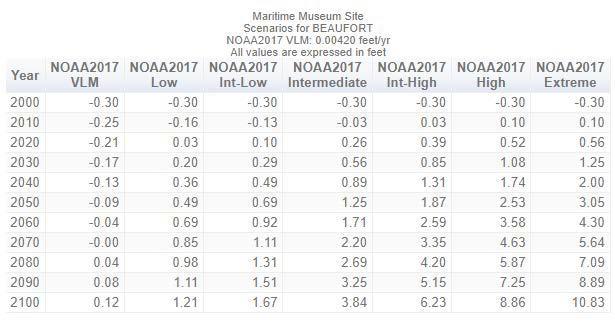
The U.S. Army Corps of Engineers (USACE) has been working on climate change adaptation research since the 1980s. The project site is less than 1 mile from a weather station whose data is used to calculate the relative sea level rise curves/predictions shown below with the USACE Sea Level Change Curve Calculator, based on the NOAA 2017 model developed and published in the report mentioned above. The Intermediate curve predicts a 1.25-foot rise in MSL by 2050 and an approximate 3.8-foot rise by 2100. See the graph and table below for low and high scenario predictions.
USACE Sea Level Change Curve Calculator (2021.12)


DOCUMENTS - Shoreline Protection/Stablization Alternative Memorandum
Maritime Museum at Beaufort Shoreline Protection Analysis
84
The USACE Sea Level Change Curve Calculator can also make predictions using other data models. The following output is based on the model presentedin the Regional Sea Level Scenarios for Coastal Risk Managementreport published by the Strategic Environmental Research and Development Program in the Department of Defense (2016) and assisted by scientists from government, universities and non-profits. It is shown here to compare with the more recentmodel predictionsand to show the similarities in the results.

Shoreline
Maritime Museum at Beaufort
Protection Analysis
85
The NOAA Office of Coastal Management hosts a website, the Coastal Flood Exposure Mapper (https://coast.noaa.gov/digitalcoast/tools/flood-exposure.html), which providesillustrations of the 2017model for various scenarios related to coastal climate change and SLR. Hazard layers of the model include Coastal Flood Hazard Composite, High Tide Flooding, FEMA Flood Zones, Storm Surge and Sea Level Rise.The following images are clipped from that web tool and summarize some of the model output for the project site.

Shoreline Protection Analysis
Maritime Museum at Beaufort
86
Maritime Museum at Beaufort Shoreline Protection Analysis
Sea Level Rise 0 Feet above Mean Higher High Water (MHHW) the average of the higher of the two high water heights of each tidal day, averaged over the U.S. National Tidal Datum Epoch

DOCUMENTS - Shoreline Protection/Stablization Alternative Memorandum
87
Maritime Museum at Beaufort Shoreline Protection Analysis

DOCUMENTS - Shoreline Protection/Stablization Alternative Memorandum
88
Sea Level Rise 1 Foot Above MHHW(just below the 2050 model prediction)
Sea Level Rise 2 Feet Above MHHW(2060’s)
 Maritime Museum at Beaufort Shoreline Protection Analysis
89
Sea Level Rise 3 Feet Above MHHW(2080’s)
 Maritime Museum at Beaufort Shoreline Protection Analysis
90
Maritime Museum at Beaufort Shoreline Protection Analysis
Sea Level Rise 4 Feet Above MHHW(2010-2110)

DOCUMENTS - Shoreline Protection/Stablization Alternative Memorandum
91
Maritime Museum at Beaufort Shoreline Protection Analysis

Sea Level Rise 5 Feet Above MHHW(~100 years from present)
The Coastal Flood Hazard Composite output is below. From the website, the descriptionof the Coastal Flood Hazard Composite model “shows areas prone to flooding from one or more of the following hazards:
High tide flooding
High risk (1% annual chance for A and V zones) and moderate risk (0.2% annual chance) flooding (designated by the Federal Emergency Management Agency)
Storm surge for category 1 through category 3 hurricanes
Sea level rise scenarios of 1, 2, and 3 feet.”
The darker the color on the map, the more flood hazard zones there are for that area.
DOCUMENTS - Shoreline Protection/Stablization Alternative Memorandum
92
The lowest rating on the site is a 4Hazard Zone (indicating FEMA floodplain and storm surge exposure to Category 2 and 3 hurricanes). Much of the forested area east of W. Beaufort Road Extension is rated 6 or 7, 7 indicating the same hazard exposure as a 4, with added high tide flooding and flooding with SLR of 2feet exposures. The highest ratings, 8-9, are mapped on the shoreline north of the docks. These areas have the same hazard exposure as 7 with SLR of 1, 2 and 3 feet exposures.
The Coastal Flood Exposure Mapper also illustrates High Tide Flooding, included below.From the website information, High Tide Flooding “illustrates low-lying coastal areasprone to flooding during extreme high tides. Extreme high tides occur a few times per year when the sun, moon, and earth align, or during storm events. Rainfall or wind pushing water over land can increase flooding levels. Annual occurrences of high tide flooding—exceeding local thresholds for minor impacts to infrastructure—have increased 5-to 10-fold since the 1960s in several U.S. coastal cities. In a sense, today’s flood will become tomorrow’s high tide, as sea level rise will cause flooding to occur more frequently and last for longer durations of time.”
 Maritime Museum at Beaufort Shoreline Protection Analysis
93
At current sea level, areas mapped along the shoreline and in the forested wetlands located on the east portion of the siteare prone to high tide flooding.
The FEMA 100-yr and 500-yr floodplains are mapped in the clip below.The entire project site is in the 100-year floodplain.
 Maritime Museum at Beaufort Shoreline Protection Analysis
94
Maritime Museum at Beaufort Shoreline Protection Analysis
The Coastal Flood Exposure Mapper’s Storm Surge mapping “shows storm surge inundation scenarios created by the National Hurricane Center (NHC) Storm Surge Unit with the Sea, Lake, and Overland Surges from Hurricanes (SLOSH) model. SLOSH is used to calculate storm surge heights and the extents of inundation for hurricane evacuation studies. Hurricane storm surge heights are influenced by many factors, including hurricane intensity (categorized by the Saffir Simpson hurricane wind scale, ranging from 1 to 5), size (radius of maximum winds), forward speed, the angle of approach to the shoreline, and the characteristics of the coastline. Since many factors influence storm surge heights, maximum inundations from multiple storm surge scenarios are composited into one data layer…..Areas within storm surge zones for a Category 1 hurricane have the greatest exposure.”

DOCUMENTS - Shoreline Protection/Stablization Alternative Memorandum
95
Storm Surge Category 1 Storm
Most of the site, except for the northern portion and part of the north side of the existing parking lot,is mapped as being flooded by 1-3 feet of water during a Category 1 storm surge.

DOCUMENTS - Shoreline Protection/Stablization Alternative Memorandum
Maritime Museum at Beaufort Shoreline Protection Analysis
96
Storm Surge Category 2
Mapping indicates that the entire site is flooded during a Category 2 storm surge. The developed area of the site’s flood level is morethan 3 feet and the forested area east of W. Beaufort Road Extension is morethan 6 feet.
 Maritime Museum at Beaufort Shoreline Protection Analysis
97
Storm Surge Category3
The mapping indicates that most of the site is inundated by morethan 9 feet of water during a Category 3 storm surge.
 Maritime Museum at Beaufort Shoreline Protection Analysis
98
Maritime Museum at
Storm Surge Category 4 below
Shoreline Protection Analysis
The modeled Category 4 hurricane surge covers all but a very small portion of the site on the north side with morethan 9 feet of water.

DOCUMENTS - Shoreline Protection/Stablization Alternative Memorandum
Beaufort
99
Maritime Museum at Beaufort Shoreline Protection Analysis
Category 5 Storm Surge below
The modeled Category 5 hurricane surge covers all of the site with morethan 9 feet of water. Finally, the Flood Factor website (https://floodfactor.com/) can produce an array of interactive analyses for flooding.It predicts risk factors for actual mapped infrastructure on the ground. From the description on the website, Flood Factor uses the First Street Foundation Flood Model to calculate and model risk. The model is a nationwide, probabilistic flood model that shows any location’s risk of flooding from rain, rivers, tides, and storm surge. It builds off of decades of peer-reviewed research and forecasts how flood risks will change over time due to changes in the environment.“Probabilistic” means the model considers uncertainty and outputsthroughout a range of likelihoods. It calculates the likelihood of a flood occurring in any given year based on climate data, proximity to water and elevation. It estimates a range of return periods for flooding events and analyzes select probabilities (0.2%, 1%, 10%, 20%, 50%) that flooding will occur, to build a set of hazard risk categories. Using 1980-2010 as a baseline period, the model analyzes multiple environmental possibilities under the RCP 4.5 carbon emissions scenario with high and low uncertainty bounds. The resulting high, median, and low environmental scenarios are then used as inputs when calculating current and future flood risks to show how flood risks will

DOCUMENTS - Shoreline Protection/Stablization Alternative Memorandum
100
change in fifteen and in thirty years.Flood Factor scores increase as the 30-year cumulative flood likelihood increases, or as the projected depth of flooding increases. Properties with higher Flood Factors are either more likely to flood, are more likely to experience high floods, or both.
The results for the site are included below, where the mapped structures are shown as having extreme flood risk.

Shoreline Protection
Based onthe predictive information presented above, it’s likely that the project site will experience increasing probabilityof shoreline erosionin the future. There are solutions to shoreline erosion that run the spectrum of design intensity from simply planting and establishing marsh vegetation to more intensively engineered solutions. Examples of different types of shoreline stabilization techniques are shown below, from those that use or mimic natural structures to restore and promote habitat, to highly engineered revetments and bulkheadsthat are poor habitat foraquatic species.
Maritime Museum at Beaufort Shoreline Protection Analysis101
Site Specific Conditions and Stabilization Opportunities
Scientists from the NOAA National Centers for Coastal Ocean Science's Beaufort Laboratory teamed with The Nature Conservancy andcreatedaweb-based interactive Living Shorelines application“by bringing in their research on the relationship between salt marsh distribution and shorelinewave energy in central coastal North Carolina.” (https://coastalscience.noaa.gov/news/nccos-partners-nature-conservancy-create-new-livingshorelines-app/). The app is an expansion of the Conservancy'sCoastal Resilience tool,in development since 2007.The app is not intended to be a substitute for detailed shoreline study and engineering, it is intended to be used by property owners seeking to determine if a living shoreline might be a feasible choice for shoreline stabilization, based on currently mapped wind/wave andboat wake energies and the width of the existing salt marsh. The output from the app for the site is presented below. It indicates thatbased on the model, an oyster reef living shoreline would be stable under current conditions.Of note is that some shoreline areas in the vicinity are mapped as requiringmore design engineering due to higher wave energies. The less-engineered solutions should stabilize the shoreline and improve habitat currently, however, in the future, more intensively engineered solutions may be necessary to protect the site’s shoreline.

Maritime Museum at Beaufort Shoreline Protection Analysis
102
Maritime Museum at Beaufort
Shoreline Protection Analysis

An example of an oyster bag/reefliving shoreline design and implementation from South Carolina (SCDNR 2019) is presented in the images below.

DOCUMENTS - Shoreline Protection/Stablization Alternative Memorandum
103
Maritime Museum at
Shoreline Protection Analysis
Appropriate site conditions of slope, bottom material, etc. should be confirmed before concluding that any type of oyster bag living shoreline design is feasible.
There is an oyster bag design living shoreline nearby at the Duke Marine Lab. Below are some images of it before hurricane Florence in 2018 and 9 days after. At this location,Florence was a Category 1 storm pushing a 2-5 foot surge. Maximum sustained windspeed was 75 miles per hour, with tropical storm force winds persisting for over 3 days. This structure remained stable and only minimal shoreline erosion was sustained.
There are a number of options for oyster bag/reef living shoreline design. TheN.C. Coastal Federation (NCCF) has a very well-developed living shoreline program that may prove very useful in determining the appropriate stabilization approach for the project site shoreline. Biohabitats contacted the NCCF and they have expressed interest in providing assistance in evaluating the site and potentially installing a living shoreline for it. They currently have funding, but it is cyclical and action would need to be taken soon to complete the process before funding is expended. The contactis Dr. Lexia Weaver lexiaw@nccoast.org

DOCUMENTS - Shoreline Protection/Stablization Alternative Memorandum
Beaufort
104

 Maritime Museum at Beaufort Shoreline Protection Analysis
105
Figure 1. Duke Marine Lab living shoreline before (above) and after (below) Hurricane Florence in September 2018.
References
Hall, J.A., S. Gill, J. Obeysekera, W. Sweet, K. Knuuti, and J. Marburger. 2016. Regional Sea Level Scenarios for Coastal Risk Management: Managing the Uncertainty of Future Sea Level Change and Extreme Water Levels for Department of Defense Coastal Sites Worldwide. U.S. Department of Defense, Strategic Environmental Research and Development Program. 224 pp.
Kunkel, K.E., D.R. Easterling, A. Ballinger, S. Bililign, S.M. Champion, D.R. Corbett, K.D. Dello, J.P. Dissen, G.M. Lackmann, R.A. Luettich, Jr., L.B. Perry, W.A. Robinson, L.E. Stevens, B.C. Stewart, and A.J. Terando, 2020: North Carolina Climate Science Report North Carolina Institute for Climate Studies, 233 pp. https://ncics.org/nccs
SCDNR. 2019. Summary of Living Shoreline Research to Inform Regulatory Decision-Making in South Carolina. Charleston, SC: South Carolina Marine Resources Division. Technical Report No. 110. 49 p. Sweet, W.V., R.E. Kopp, C.P. Weaver, J. Obeysekera,R.M. Horton, E.R. Thieler, and C. Zervas, 2017: Global and Regional Sea Level Rise Scenarios for the United States. NOAA Technical Report NOS CO-OPS 083. NOAA/NOS Center for Operational Oceanographic Products and Services. https://repository.library.noaa.gov/view/noaa/18399
Sweet, W.V., B.D. Hamlington, R.E. Kopp, C.P. Weaver, P.L. Barnard, D. Bekaert, W. Brooks, M. Craghan, G. Dusek, T. Frederikse, G. Garner, A.S. Genz, J.P. Krasting, E. Larour, D. Marcy, J.J. Marra, J. Obeysekera, M. Osler, M. Pendleton, D. Roman, L. Schmied, W. Veatch, K.D. White, and C. Zuzak, 2022: Global and Regional Sea Level Rise Scenarios for the United States: Up-dated Mean Projections and Extreme Water Level Probabilities Along U.S. Coastlines. NOAA Technical Report NOS 01. National Oceanic and Atmospheric Administration, National Ocean Service, Silver Spring, MD, 111 pp. https://oceanservice.noaa.gov/hazards/sealevelrise/noaa-nos-techrpt01-global-regionalSLR-scenarios-US.pdf
USACE Sea Level Change Curve Calculator (2021.12), https://cwbiapp.sec.usace.army.mil/rccslc/slcc_calc.html
Maritime Museum at Beaufort Shoreline Protection Analysis106
107
Maritime Museum ofBeaufort
Site Development Sensitivity Analysis Biohabitats, Inc.


108
March,2022
DOCUMENTS - Site Development Sensitivity Analysis Map and Memorandum Maritime Museum at Beaufort Ecological Sensitivity Analysis Contents Introduction & Data Collection.........................................................................................3 Site Area Descriptions.....................................................................................................3 Ecological Sensitivity Analysis........................................................................................5 Results............................................................................................................................7 Figures and Table 1........................................................................................................8 109
Introduction& Data Collection
The site for the future Maritime Museum at Beaufort comprises 30+ acres and is situated mostly north of the US 70 bridge. West Beaufort Road Extension splits the site diagonally from northwest to southeast. Gallant’s Channel borders the site on the west side. Elevation ranges from approximately 3 to 5 feet above meansea level.
This report provides an overview of the site’s ecological status and defines Areas of the site in terms of their ecological sensitivityand values they offer, which can be usedas a guide to their suitability for development.Areas were considered to be ecologically sensitive based on community type, quality, and configuration. Generally, wetlands and mature forest add to the biodiversity of the landscape, so those areas were scored as more sensitive. Areas that had a heavy presence of invasive species or small areas of intact, contiguous habitat were deemed less ecologically sensitive.
Biohabitats gathered background desktop information on the site, including soils mapping, parcel boundaries, and aerial photography and created field maps. Using the materials gathered and maps, Biohabitats visited the site on January 27, 2022.
Biohabitats staff walked the site and collected information on vegetation communities present, notable natural features, and areas of disturbance. The information was recorded and synthesized in the office.
Site Area Descriptions
Based on the field review, the site was divided into individual Areas definedby combination of similar ecological characteristics and parcel lines. Vegetation and natural conditions within each area are described below. An environmental sensitivity index, based on the presence of jurisdictional features such as wetlands or Areas of Environmental Concern, presence of healthy native vegetation, presence of invasive species, habitat patch size and level of disturbance/development was used to differentiate Areas of the site according to ecological value and sensitivity. Development in jurisdictional wetlands requires permitting through the U.S. Army Corps of Engineers and N.C. Department of Environmental Quality, Division of Water Resources. Development in coastal Areas of Environmental Concern ispermitted through the Coastal Area Management Act, administered by the N.C. Division of Coastal Management. Please refer to Figure 1 (at the end of the document) for locations of the following Areas and Table 1 (included at the end of the document) for a list of vegetation species identified in each Area. Descriptions of the Areas follow.
Area1
This Area occupies approximately 1.1 acre. The majority of it is a jurisdictional wetland. Most of the vegetation appears to be approximately 30 years old, although the stature of the trees doesn’t reflect that age, probably due to past site disturbanceand constant wet conditions that limit growth rates. The Area is ecologically sensitive due to the wetland status and intact native vegetation. Characteristics that moderate or detract from ecological value are the relatively young vegetation age and the presence of invasive species, which can spread and diminish habitat value, species diversity and ecological resilience.
DOCUMENTS - Site Development Sensitivity Analysis Map and Memorandum
Maritime Museum at Beaufort
Ecological Sensitivity Analysis
110
Area 2
This Area occupies approximately 0.3 acre. Similar to Area 1, Area 2 is predominantly a jurisdictional wetland, the vegetation appears to be approximately 30 years old and of comparable stature. Area 2 is ecologically sensitive due to the presence of jurisdictional wetlands and intact native vegetation. Characteristics that moderate or detract from ecological value are the relatively young vegetation age, small size of the Area and the presence of invasive species, which can spread and degrade habitat value, species diversity and ecological resilience.
Area 3
This Area is approximately 1.4 acre underneath and south of the bridge. The boundary isn’t specifically defined, but the Area is estimated to be approximately 1 acre and has been cleared of woody vegetation. There is a picnic shelter that appears to be recently constructed in the landward portion. It supports a narrow band of Spartina and salt cordgrass along the shoreline, which indicatescoastal wetlands by definition, though it has not been delineated. There are a few scattered bushy bluestem stems in the upland area, and a stand of invasive Phragmites in a semi-circular ditch around the picnic shelter. Except for the coastal wetland area, this is not an ecologically sensitive area due to past disturbance.
Area 4
This Area is approximately 0.4 acre. It is almost entirely a jurisdictional wetland, with coastal or tidal wetlands along the shoreline. Similar to Areas 1 and 2, the vegetation is approximately 30 years old. Area 4 is ecologically sensitive due to jurisdictional wetlands and intact native vegetation and the presence of stabilizing vegetation along the shoreline. Characteristics that moderate or detract from ecological value are the relatively young vegetation age, small size of the Area and the presence of invasive species, which can spread and degrade habitat value, species diversity and ecological resilience.
Area 5
This narrow shoreline Area (~1.2 ac) is where the docks and pier are located and consists primarily of salt marsh (coastal wetlands) and a smaller area of non-tidal wetland and scattered uplands along the shoreline. The vegetation is mostly herbaceous wetland marsh, with scattered shrubs (see Table 1). This area is ecologically sensitive due to regulatory protection and landscape position.
Area 6
This is a relatively large area characterized by both native forest (predominantly loblolly pine and red maple), disturbed areas, and areas of invasive species infestation. It is approximately 6.9 acres and includes an apparent sand borrow or potentially a remediation area of approximately 0.45 acre, and an area of heavy invasive species presence of approximately 3.6 acres. Within the entire Area are sensitive areas, interspersed with disturbed or ecologically degraded areas with dominant invasive species.
Maritime Museum at Beaufort Ecological Sensitivity Analysis
111
Area 7
Area 7 is approximately 6.2 acres and is defined by the parcel property lines on the east side of West Beaufort Road Extension. It is completely forested, the dominant canopy species in the northwestern end is loblolly pine, approximately 50 to 60 years-old and multiple live oaks in the sub-canopy. This is a typical coastal forest community (species listed in Table 1). There is a substantial amount (~2.5 acres) of jurisdictional wetland delineated in the Area. Red maple is the dominant canopy species in the wetland area. Area 7 is ecologically sensitive due to jurisdictional wetlands and intact, maturing, native vegetation, with a relatively low invasive species presence observed in the rapid field assessment.
Area 8
Area 8 is approximately 3.4 acres (based on GIS measurements, not the County web GIS site) and is defined by parcel boundaries. Similar to Area7 it has areas of loblolly pine dominated canopy, along with a freshwater wetland dominated by red maple forest, which is mapped to cover most of the parcel. There are also two coastal wetlands mapped, and a small area of maritime salt marsh, dominated byblack needlerush. Area 8 is ecologically sensitive due to the jurisdictional wetland extents, the wetland diversity present, and the maturing native forest canopy.
Area 9
Area 9 is approximately 1.25 acres and is a teardrop-shaped area, apparently in theNC DOT right of way. While not within the current wetland delineation boundary, it visually appears to be a jurisdictional wetland, both coastal and freshwater. The vegetation is similar to that ofAreas 1 and 2.
Area 10
Area 10 is approximately 10 acres, and is occupied predominantly by pavement, turfgrass and buildings, with a small pond and wetland area located in the northwestern end. This area, except for the jurisdictional wetland, has a substantially lower ecological sensitivity than the other areas.
Ecological Sensitivity Analysis
For this master planning effort, ecological sensitivity is described using a selected set of ecological characteristics, which are indicators of site ecological resiliency, such as vegetation maturity, vegetation and habitat diversity, invasive species presence, etc. Sensitive areas contribute to local resilience by providing habitat and services such as carbon sequestration, soil stabilization, stormwater runoff control, and native seed sources which, if lost to development, would reduce the species richness of the site. Through the ecological sensitivity analysis,areas that are less ecologically sensitive (i.e. most suitable for development) can be identified and their boundaries defined and mapped for use in the site design process.
Jurisdictional wetlands and streams and shoreline areas that have regulatory development restrictions (Clean Water Act and CAMA respectively) are allclassed as sensitive areas. An area with mature, intactnative vegetation, which provides ecosystem services such as carbon sequestration, air purification, wildlife habitat and heat island buffering is another familiar
Maritime Museum at Beaufort Ecological Sensitivity Analysis
112
example of an ecologically sensitive area. Levels of sensitivity vary, and examples of less sensitive areas include those that are occupied by less mature vegetation with a lower opportunity cost for replacement, areas where fewer vegetation species occur, and areas infested with invasive species.
The sensitivity analysis identifies site ecological assets and uses a “scoring” system to assign points based on assets present in that area. Point values for the assets are assigned based on a qualitative relative ecological value or sensitivity. Categories were chosen and points were assigned to category ranges based on basic ecological principles and best professional judgement.
Points are intended to do two things; to qualitatively assign a sum of values (point total) to a particular area based on its unique characteristics, and to create numeric values (point totals for all the respective areas) that allow for the placement of individual areas of the site along a “low to high” value continuum bounded by the lowest and highest scores, i.e. the range of scores. For this analysis, the ecological attributes or categories utilized were:
1.Wetlands (freshwater and tidal)
2.Areas of Environmental Concern (CAMA 75’ shoreline buffer)
3.Forest Age (in years)
4.Woody Vegetation Species Diversity (number of species observed)
5.Invasive Species Percent Cover
6.Habitat PatchSize (acres)
A single,high point score was assigned to all wetlands by default based on their sensitivity and legal protection. Areas of Environmental Concern received slightly lower score than wetlands to reflect the marginally more flexible CAMA permitting process. The remaining four categories were divided into 6 levels with increasing points for each level. For example, points were assigned to forested areas based on estimated age, younger tree ages received less points, higher ages received more points (See Table 2). Similarly, points were assigned to the remaining categories, with fewerpoints to the less sensitive areas, more points to the more sensitive (Table 2.). Each Area of the site was assigned points for each category based on conditions observed. Determination of how many points an area received was based on field and desktop review and best professional judgement. To reiterate, the purpose of this analysis was to assess the site and determine in a comparativeand science-based qualitative way, which areas have higher ecological integrity vs. the areas with less ecological value, and map the locations of the differences as a planning exercise, rather than to quantitatively assess the various areas and derive absolute scientific values for forest habitat (or commercial value for that matter) value, Shannon-Weaver vegetation diversity index, etc. This is a ranking technique, not a quantitative scientific parameters study.
The scores for each of the Areas were compiled and classed into groups with aJenks Natural Breaks statistical procedure. The Natural Breaks procedure analyzes the scores and assigns the scores to the number of groups or categories that the analyst specifies. From the ESRI GIS Dictionary (https://support.esri.com/en/other-resources/gis-dictionary), the Jenks Natural Breaks procedure is a “method of manual data classification that seeks to partition data into classes based on natural groups in the data distribution.” In this analysis,3 categories or classes were
DOCUMENTS - Site Development Sensitivity Analysis Map and Memorandum
Maritime Museum at Beaufort
Ecological Sensitivity Analysis
113
specified, dividing the scores into 3 groups or classes-low, medium and high, which translate into low, medium and high ecological sensitivity areas.
Table 2. Sensitivity Analysis Categories and Values
Points
Forest Age (yrs)
Woody Species Diversity (# of spp.)
Invasive Species % Cover Patch Size (ac) 0 >33 2 0-15 0-3 25-33 <0.5 4 15-30 4-5 15-25 0.5-1.5 6 30-45 6-8 10-15 1.6-3 8 45-60 9-11 5-10 3.1-5 10 60+ 12+ <5 >5.1
Results
The results of the Natural Breaks analysis are: Ecological Sensitivity Points Range Area (ac) # of Areas in Class Low 12-16 (5 pt.range) 13.3 5 Medium 17-22 (6 pt.range) 6.1 4 (including AEC) High 23-36 (14 pt.range) 12.9 3
There are 5 Areas in the Low class, 4 in the Medium class (including the 75’ shoreline AEC outside of wetland areas) and 3 in the High Ecological Sensitivity classes. There are approximately 13 acres in the Low and High classes, and 6 acres in the Medium Ecological Sensitivity class (see Figure 2 at the end of the document).
The ecological sensitivity analysis illustrates the areas of high ecological sensitivity northeast of West Beaufort Road Extension and on the northwestern end of Area 6, along with the wetlands. The portion of Area 6 that is heavily infested with invasive species has medium sensitivity, because the area could be restored to a high ecological value area if the invasive species were eradicated. Area 9 is a medium sensitivity area in the analysis, but it needs a wetland delineation to determine if additional jurisdictional wetlands are present besides the marsh area visible from the road and aerial photography. The low sensitivity class has the most areawhere developmentwill not impact any sensitive ecological resources (Areas 3 and 10).
DOCUMENTS - Site Development Sensitivity Analysis Map and Memorandum
Maritime Museum at Beaufort Ecological Sensitivity Analysis
114
Figures and Table 1

Ecological
Maritime Museum at Beaufort
Sensitivity Analysis
115

Ecological
116
Maritime Museum at Beaufort
Sensitivity Analysis
Table 1. Species Observed by Area
Area 1 Southeast of Parking Lot, NE Side of Abandoned House
Common Name Botanical Name
wax myrtle Morella cerifera black willow Salix nigra Japanese privet Ligustrum japonicum red bay Persea borbonia multiflora rose Rosa multiflora Eastern red cedar Juniperis virginiana
Area 2 Small Area Southwest of Abandoned House
Common Name Botanical Name
wax myrtle Morella cerifera black willow Salix nigra Japanese privet Ligustrum japonicum red bay Persea borbonia multiflora rose Rosa multiflora Eastern red cedar Juniperis virginiana honeysuckle Lonicera japonica Chinese privet Ligustrum sinense
Area 3 Area South and Underneath Bridge
Common Name Botanical Name Phragmites Phragmites australis bushy bluestem Andropogon glomeratus smooth cordgrass Spartina alternaflora/Sporobolus alternaflora salt meadow cordgrass Spartina patens
Area 4 Area North of Bridge and South of Docks Along Shoreline
Common Name Botanical Name bagpod Sesnania vesicarium flatsedge Cyperis strigosus wax myrtle Morella cerifera
DOCUMENTS - Site Development Sensitivity Analysis Map and Memorandum
10
Maritime Museum at Beaufort Ecological Sensitivity Analysis
117
Table 1. Continued
red maple Acer rubrum Chinese privet Ligustrum sinense
Area 5 Docks and Shoreline
Common Name Botanical Name smooth cordgrass Spartina alternaflora/Sporobolus alternaflora sea ox-eye Borrichia frutescens groundsel tree Baccharis halimifolia bushy bluestem Andropogon glomeratus Virginia wildrye Elymus virginicus Canada goldenrod Solidago altissima
salt penny wort Hydrocotyl bonariensis groundsel tree Baccharis halimifolia smooth cordgrass Spartina alternaflora/Sporobolus alternaflora saltmarsh finger grass Eustachys glauca
Area 6 NW forested area-nature trail and sand borrow
Common Name Botanical Name live oak Quercus virginiana Eastern red cedar Juniperis virginiana black cherry Prunus serotina wax myrtle Morella cerifera loblolly pine Pinus taeda greenbrier Smilax bona-nox yaupon Ilex vomitoria dog fennel Eupatorium cappillfolium privet Ligustrum ssp common reed Phragmites australis
Area 7 N parcel on E side of W Beaufort Rd Extension, where nature trail is
Common Name Botanical Name loblolly pine Pinus taeda
DOCUMENTS - Site Development Sensitivity Analysis Map and Memorandum
11
Maritime Museum at Beaufort Ecological Sensitivity Analysis
118
Table 1. Continued
black needle rush Juncus roemerianus salt grass Distichlis spicata
Area 9 traffic island Common Name Botanical Name
red maple Acer rubrum wax myrtle Morella cerifera Eastern red cedar Juniperis virginiana live oak Quercus virginiana loblolly pine Pinus taeda yaupon Ilex vomitoria black willow Salix nigra groundsel tree Baccharis halimifolia winged sumac Rhus copallina privet Ligustrum spp. Saltmarsh
black needle rush Juncus roemerianus salt grass Distichlis spicata
Area 10 Cleared and Developed Area in the Middle of the Site
Bermudagrass Cynodon spp. loblolly pine Pinus taeda red maple Acer rubrum wax myrtle Morella cerifera
13
Maritime Museum at Beaufort Ecological Sensitivity Analysis
119

120

121

122

123

124

125

126

127

128

129

130

131

132

133
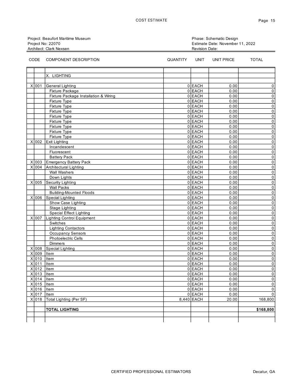
134

135

136

137

138

139

140

141

142
143
“A Place for Everyone, by the Sea”