
by

Robert Raker CEO/GM
When I stepped into this role, I knew there would be more meetings—but I didn’t realize how many directions I’d be pulled in. Welcome to 2025.
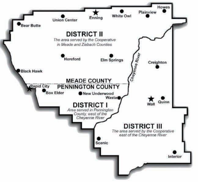
One of those meetings I attended was a public forum in New Underwood focused on utility scale solar, more specifically, the Wild Springs Solar Project. It was well attended and, let’s just say, lively. The community raised valid concerns—land use, transparency, and local tax impacts among them. I appreciated the opportunity to hear directly from folks in our service area. 100488
As much as I’d have liked to sit quietly in the back, it became clear that many had a genuine desire to understand what role electric cooperatives play in these decisions. The short answer? We don’t have much of a role at all in projects like Wild Springs Solar because we don’t control private land development or sit on permitting boards. Where we do have a responsibility is to be your trusted energy advisors. So, when it comes to energy development, our job is to share the full picture with lawmakers, regulators, and our members. As for Wild Springs, and utility scale solar in general, we have tried to get it so the taxes stay local. That’s proven to be difficult, and maybe now it’s time to have those discussions again. 11215300
The main driving factor as to what is built for generation is economics. If power providers can negotiate a good enough deal, they will purchase it. Especially power providers with the obligation
to serve, like our power provider Basin Electric Cooperative. They have the responsibility to supply electricity to 139 different electric cooperatives in 9 states. So, when they can secure the sale of electricity at a reasonable rate, they do.
Another major factor and what often drives the economics—is regulations and laws. Today, many current laws and market forces have set the industry toward more solar and wind. However, these resources are not always available when we need them most. On the bright side, we are seeing a shift that prioritizes reliable dispatchable loads like natural gas generation. But, building pipelines and new generation takes time, and the political landscape can shift before those projects are even completed. So, as I say to employees: let’s stay solutionfocused. Right now, the biggest solution we should be advocating for is a long-term national energy policy—one that gives utilities the certainty to make responsible investments. Next, we should ensure the communities that are most impacted by these federal decisions, receive the tax dollars.
Finally, we’ll continue advocating for an all of the above strategy, which currently needs reliable sources, because being diversified is our best option in today’s environment. Please stay safe this summer season, and as always, I enjoy hearing feedback from you, our members.
Stay safe,
Robert Raker | CEO

(USPS No. 675-840)
Our Mission:
To serve our members’ best interest.
Our Vision:
We will be a high performing co-op.
Our Values:
1. Safety 2. Accountability 3. Integrity 4. Innovation 5. Commitment to Community
This institution is an equal opportunity provider and employer.
Board President: Andy Moon Board of Directors
Stan Anders – Vice President
Jamie Lewis – Secretary
Chuck Sloan – Treasurer
Larry Eisenbraun
Peter Blake
Marcia Arneson
Steven Edoff
Sue Peters
CEO and General Manager:
Robert Raker –robert.raker@westriver.coop
Editor
Amanda Haugen –amanda.haugen@westriver.coop
WEST RIVER ELECTRIC COOPERATIVE CONNECTIONS is the monthly publication for the members of West River Electric Association. Members subscribe to Cooperative Connections as part of their electric cooperative membership for $6 a year. West River Electric Cooperative Connections purpose is to provide reliable, helpful information to electric cooperative members on matters pertaining to rural electrification and better living. Nonmember subscriptions are available for $12 per year. Periodicals Postage paid at Wall, S.D., and at additional mailing offices. Postmaster: Send address changes to West River Electric Cooperative Connections, PO Box 412 , Wall, SD 57790-0412.
Other correspondence to: West River Electric Cooperative Connections, 3250 E Hwy 44, Rapid City, SD 57703; telephone (605)393-1500, Exts. 6564, 6531 or 6522; fax (605)393- 0275; e-mail amanda.haugen@westriver.coop.

August marks the return to school for students across our community, and that means it’s time for all of us to slow down and stay alert.
Drivers:
• Always obey school zone speed limits, even if you don’t see children right away.
• Watch for students crossing streets, especially near buses and crosswalks.
• Never pass a school bus that is stopped with red flashing lights — stop and wait until the bus moves again.
• Stay alert for new bus routes and changing traffic patterns near schools.
• Remind children to look both ways before crossing the street and to cross only at marked crosswalks.
• Teach kids to avoid distractions, like using phones while walking.
• Encourage them to walk with a friend or group whenever possible.
• Stay distraction-free behind the wheel. Put your phone away and keep your eyes on the road.
• Expect the unexpected — kids can move quickly and unpredictably.
Working together, we can help make this school year a safe and successful one for every student. Let’s keep safety at the top of our class!

Source: National Safety Council
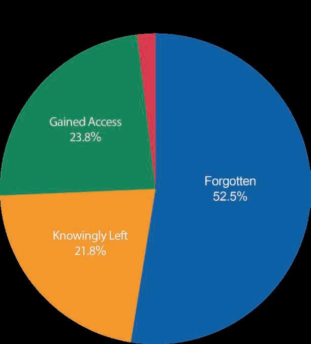
Since 1998, more than 1,010 children have died from vehicular heatstroke, an average of 37 per year. Parents and caregivers can act immediately to end these preventable deaths.
Even on mild or cloudy days, temperatures inside vehicles can reach life-threatening levels. Leaving windows slightly open doesn't help. Children should never be left unattended or be able to get inside a vehicle. Three primary circumstances resulting in deaths of children in hot cars are:
• A caregiver forgets a child in a vehicle - 53%
• A child gains access to a vehicle - 24%
• Someone knowingly leaves a child in a vehicle - 22% NSC advises parents and caregivers to stick to a routine and avoid distractions to reduce the risk of forgetting a child. Place a purse, briefcase or even a left shoe in the back seat to force you to take one last look before walking away. Keep car doors locked so children cannot gain access and teach them that cars are not play areas. There is no safe amount of time to leave a child in a vehicle, even if you are just running a quick errand.

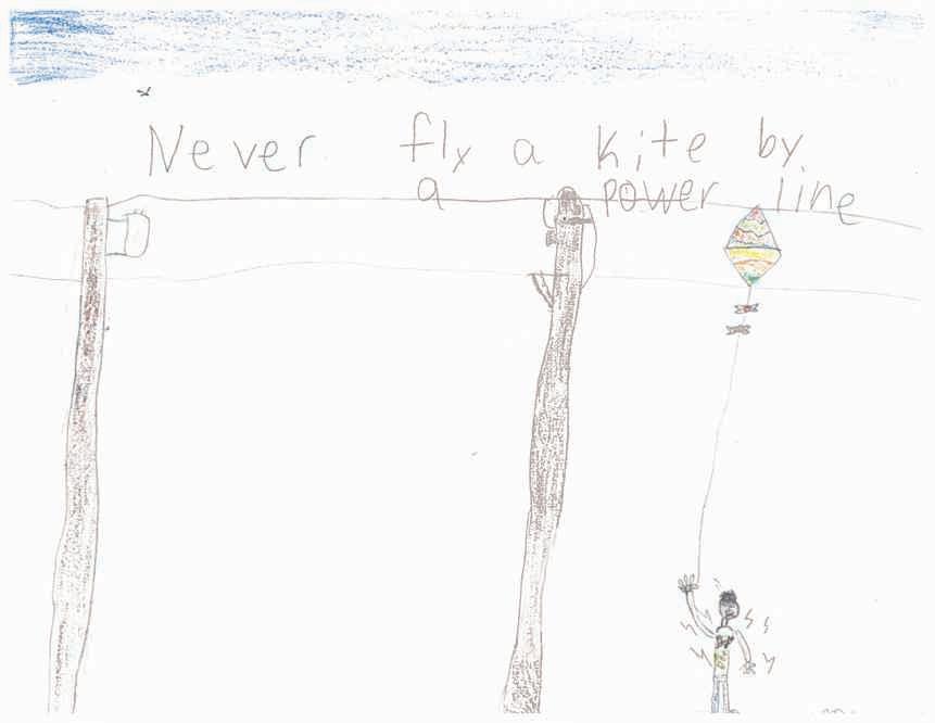
“Never fly a kite by a power line!”
Kasen warns readers about the dangers of flying a kite near power lines.Thank you for your picture, Kasen! Kasen's parents are Corey and Marcel Tikka from Lake Norden, S.D.
Kids, send your drawing with an electrical safety tip to your local electric cooperative (address found on Page 3). If your poster is published, you’ll receive a prize. All entries must include your name, age, mailing address and the names of your parents. Colored drawings are encouraged.

Ingredients:
1/2 cup butter
1 cup all-purpose flour
1 tbsp. sugar
8 oz. pkg. cream cheese
1 cup powdered sugar
8 oz. Cool Whip (reserve part for topping)
1qt. blueberries (fresh or frozen)
1 cup water
1 cup sugar
3 tbsps. cornstarch
Method
Ingredients:
1 angel food cake (baked and cut in pieces)
3.9 oz vanilla pudding
1 3/4 cups milk
3 cups sliced strawberries
¼ cup sugar
8 oz. Cool Whip, thawed
Method
Put the angel food cake in a 9"x13" pan. In a separate bowl, combine vanilla pudding and milk; whisk together until thick; set aside. In another bowl, combine sliced strawberries and sugar; pour over the cake. Spread pudding over strawberries. Top with 8 oz. Cool Whip. Add more strawberries on top. Chill 1 hour before serving.
Gladys Bauer
Cam Wal Electric
Ingredients:
stick butter
1/2 cups peanut butter
1/2 cups oatmeal
oz. chocolate chips 12 oz. plain M&Ms
Method
Mix butter, peanut butter, sugar, brown sugar, vanilla and eggs. Add dry ingredients and mix in chocolate chips and M&Ms. Bake at 350°F for 15 minutes (no longer) in a large jelly roll pan. They may not look done but they are. Enjoy!
Rhonda Tuscherer FEM Electric
Cut butter into flour and sugar. Press into a 9"x13" pan and bake at 350°F for 20 minutes. Chill. Beat cream cheese and powdered sugar until light and fluffy. Fold in Cool Whip. Spread over crust. Simmer one cup blueberries and 2/3 cup water for five minutes. Blend sugar and cornstarch; add 1/3 cup water and mix until smooth. Combine with cooked berries and boil until thick and transparent. Cool and add remaining berries. Chill thoroughly and spoon over cream cheese mixture. Chill several hours or overnight. Top with Cool Whip.
Janet Lefers
Douglas Electric
Please send your favorite recipes to your local electric cooperative (address found on Page 3). Each recipe printed will be entered into a drawing for a prize in December 2025. All entries must include your name, mailing address, phone number and cooperative name.
Amanda Haugen Communications Specialist
Now that summer is in full swing, like many of you, I welcome more opportunities to be outdoors and enjoy the warmer weather. Summertime brings many of my favorite activities like cooking out with family and friends, afternoons on the water and simply slowing down a bit to enjoy life.
But summer months also make conditions right for dangerous storms. These potential weather events can cause destruction to our electrical system, but I want you to know that West River Electric crews are ready and standing by to respond should power outages occur in our area. 1839400
When major storms knock out power, our line crews take all necessary precautions before they get to work on any downed lines. I would encourage you to also practice safety and preparedness to protect your family during major storms and outages. 443600
The Federal Emergency Management Agency recommends the items below as a starting point for storm and disaster preparedness, but you can visit www.ready. gov for additional resources.
• Stock your pantry with a threeday supply of non-perishable food, such as canned goods, energy bars, peanut butter, powdered milk, instant coffee, water and other essentials (i.e., diapers and toiletries).
• Confirm that you have adequate sanitation and hygiene supplies including towelettes, soap and hand sanitizer.
instructions to operate it safely.
• Ensure your First Aid kit is stocked with pain relievers, bandages and other medical essentials, and make sure your prescriptions are current.
• Set aside basic household items you will need, including flashlights, batteries, a manual can opener and portable, batterypowered radio or TV.
• Organize emergency supplies so they are easily accessible in one location.
In the event of a prolonged power outage, turn off major appliances, TVs, computers and other sensitive electronics. This will help avert damage from a power surge, and will also help prevent overloading the circuits during power restoration. That said, do leave one light on so you will know when power is restored. If you plan to use a small generator, make sure it’s rated to handle the amount of power you will need, and always review the manufacturer’s
Listen to local news or a NOAA Weather Radio for storm and emergency information, and check our Outage Map located on our website for power restoration updates.
After the storm, avoid downed power lines and walking through flooded areas where power lines could be submerged. Allow ample room for utility crews to safely perform their jobs, including on your property.
Advance planning for severe storms or other emergencies can reduce stress and anxiety caused by the weather event and can lessen the impact of the storm’s effects. Sign up for NOAA emergency alerts and warnings, and download our SmartHub app to stay updated of power restoration efforts and other important co-op news and information.
I hope we don’t experience severe storms this summer, but we can never predict Mother Nature’s plans. At West River Electric, we recommend that you act today because there is power in planning. From our co-op family to yours, we hope you have a safe and wonderful summer.


A trip to Washington, D.C., for a unique leadership experience.
A visit to Basin Electric, where you’ll see the cooperative business model in action.

Scholarships to support your future academic goals 605-393-1500 WWW.WESTRIVER.COOP powerup@westriver.coop


Jacob Boyko jacob.boyko@sdrea.coop
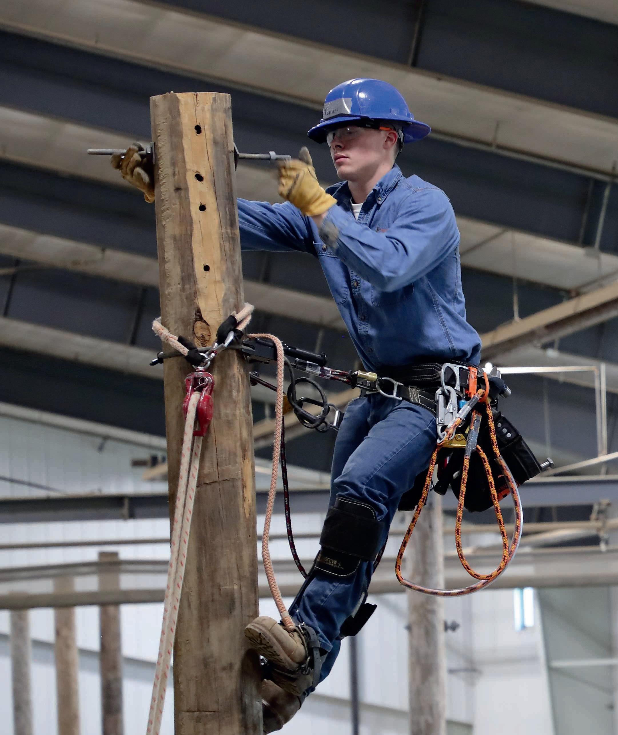
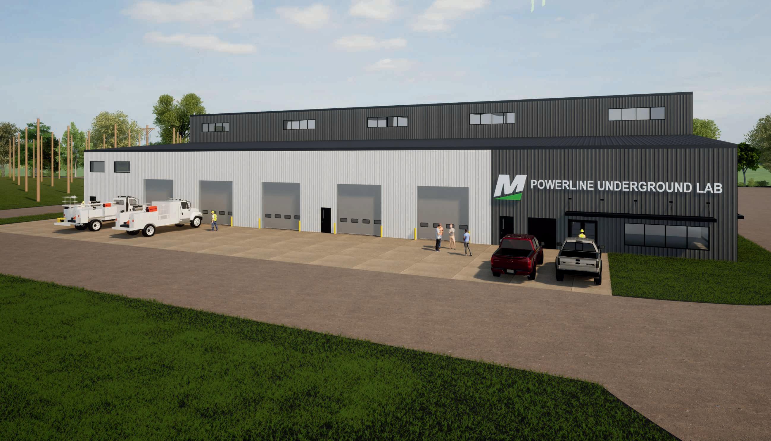
Mitchell Technical College is well known among the region’s rural electric cooperatives for its industry-leading lineworker training programs.
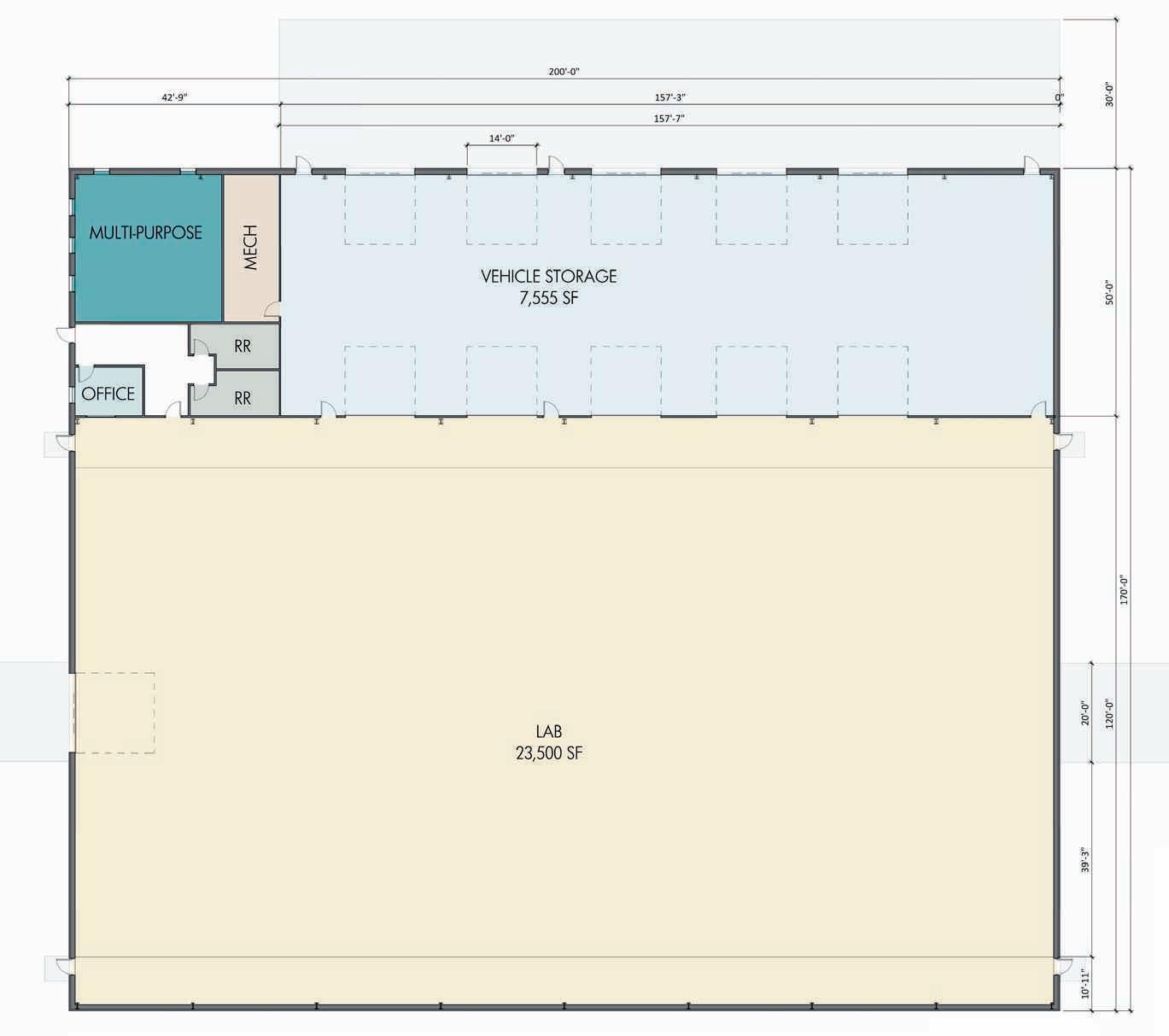
Now, that program is about to get even better, as MTC begins construction on a new, state-of-the-art underground cable equipment training facility.
The Power Line Underground Lab will allow students to learn how to trench, bore, and connect cables in an environment away from other labs and courses.
Additionally, being indoors and having a dirt floor, instructors have the added benefit of being able to plan courses without worry regarding outside weather and frozen ground during winter.
“The new facility allows us to be able to use our underground curriculum and teach it all throughout the school year, instead of just the beginning and the end when the ground is thawed out,” MTC’s president, Theresa Kriese said about the space.
“They get more equipment time because we’re not trying to
share a lab where we’re also planting poles.”
Kriese hopes spreading out the curriculum over the semester will allow MTC’s instructors to dive deeper into certain course topics with their students, making them overall better candidates for employment when they enter the workforce.
“We're seeing the energy industry making another transformation where underground is really gaining a larger presence than it had in the past”, Kriese added, noting the Federal Emergency Management Agency’s push to replace downed overhead lines with resilient underground cables after storms.
“We're finding that if we can have our students trained in both (overhead and underground), it opens some opportunities for them, because they may not be able to climb that pole their entire life,” she continued. “It gives some flexibility to the employer, because I can hire somebody that can climb but they can also do that underground connection. So wherever I need them, I can have them work in my employment area.”
Central Electric Cooperative General Manager Ken Schlimgen agrees, adding that with more and more electric co-ops working to replace their aging overhead infrastructure with underground line, MTC’s new underground focus will help alleviate future workforce challenges.
"When we support Mitchell Tech programs, it's an investment into our most important asset: our workforce," Schlimgen said. "Workforce challenges will continue for decades, and having a competent, qualified team of lineworkers to serve our members and keep the lights on is vital to our success."
Central Electric is just one electric co-op providing financial support for the expansion.
At the time of writing, more than 20 electric co-ops in South Dakota have pledged over $460,000 to MTC in support of the facility.
“Power line personnel are the backbone of our cooperative family, keeping the lights on for our members and being leaders in our communities,” said Steve Barnett, general manager for the South Dakota Rural Electric Association.
“Mitchell Technical College is a workforce pipeline for this profession and is vital to cooperatives across our region.”
Kriese said staff and student excitement is growing ahead of the facility’s expected 2026 completion and expressed appreciation to electric
co-ops for their support.
“Mitchell Tech is making a statement and a commitment to the energy industry that we are your partner in developing and training employees for you,” Kriese said.
“Without the partnership of the electric cooperatives, we really
wouldn’t be able to make this expansion."
The project is slated to celebrate its grand opening in the Fall of 2026, when students and Mitchell Tech faculty will begin using the facility to train tomorrow's electric cooperative workforce.


The deadline for petitions is August 12, 2025, by 5pm. No nominations are taken from the floor at the annual meeting. Candidates must be members of the cooperative and reside in the district they are seeking election from, be in good standing with the cooperative and not be employed or financially interested in a competing enterprise or major supplier to the cooperative. Petitions may be picked up at any of the West River Electric office locations.
Three incumbent directors, Jamie Lewis of Rapid City for District 1, Marcia Arneson of Rapid City for District 2, and Sue Peters of Wall for District 3, have announced their intent to seek re-election to the Board of Directors of West River Electric Association. 10439500

Jacob Boyko jacob.boyko@sdrea.coop
Midwest summers have a certain notoriety for their extreme summer weather events.
South Dakota is no exception. Between May 2015 and June 2025, the National Oceanic and Atmospheric Administration (NOAA) reported more than 200 tornadic events in South Dakota.
The Recipe for Severe Weather
According to Peter Rogers, warning coordination meteorologist for the National Weather Service (NWS) Office in Sioux Falls, there are four foundational components for the specific type of thunderstorms that produce tornadoes called supercells.
The first component is moisture – it's needed to form clouds. The second component, lift, refers to an upward motion of the air. In places without mountains like eastern South Dakota and western Minnesota, that occurs when a cold or warm front moves into the area and the laws of physics force warm air upward.
The third component, instability, is the
difference between the two air masses.
“If you have pockets of air that are hotter than the air around them, they’ll continue to rise,” Rogers explained. “And the instability is the extent to how far those parcels will rise.”
The final component, wind shear, is how the wind speed and direction changes with altitude.
“Here, at the surface, we’re normally only concerned about what the wind speed is doing at the surface,” Rogers explained.
“But as meteorologists, we want to know what’s happening at 5, 10, 15 … feet and so on. The more changes you have with wind speed and direction … with height increases your chances of going from just your garden-variety thunderstorm to a severe thunderstorm that's more capable of producing strong winds and tornadoes.”
Over the last 10 years, South Dakota has seen tornadoes mostly ranking EF-0, EF-1 and EF-2 on the Enhanced Fujita scale.
The scale, named for its developer, meteorologist Ted Fujita, ranks tornados on a scale from 0 to 5 based on recorded wind speed and the damage observed that can be attributed to the tornado, with an
EF-5 being the most severe.
An EF-0 tornado will leave behind damage indicators showing wind speeds between 65 and 85 mph, while an EF-1 tornado will show damage indicating wind speeds between 86 and 110 mph, an EF-2 111-135 mph, an EF-3 136-165 mph, an EF-4 166-200 mph and an EF-5 being anything over 200 mph.
But weak and strong tornadoes alike can be deadly without proper action.
Working at the National Weather Service, it's part of Roger's job to get severe weather alerts out to the public.
Weather radios are particularly helpful in severe weather scenarios, he explained, because you can set them to alert you any time the NWS sends out an alert for your area.
“Severe weather is not just an afternoon or evening phenomenon,” Rogers said.
“We often have some pretty big events in the middle of the night, so you want to have something that’s going to wake you up in the middle of the night so you can get to shelter.”

As any Midwest resident knows, there's far more summertime severe weather than just tornadoes.
Derechoes, which decimated much of eastern South Dakota and Western Minnesota in 2022, produces a wall of strong, fast gusts of wind that can be just as dangerous as a tornado.
According to the NWS, for a storm to be classified as a derecho, it must extend 250 miles with gusts of at least 58 mph and produce several gusts of at least 75 mph.
In western South Dakota, the Black Hills help create the optimal conditions needed for severe hail.
"What you need is a really strong thunderstorm that has a really strong updraft," explained Kelly Serr, warning coordination meteorologist for the National Weather Service Office in Aberdeen.
"When that updraft is really strong, it reaches the very coldest levels of the atmosphere where tiny droplets of rain start to freeze."
The stronger the draft, the longer the frozen rain drop will remain in the atmosphere. And the longer it's stuck in the updraft, the more water it collects, growing in size until finally the hail stone is too heavy to be suspended by the updraft anymore, and it plummets to the ground.
In western and central South Dakota, that process is exacerbated by the Black Hills, which help force the air up even higher and create fastdeveloping thunderstorms.
During severe weather events like thunderstorms, tornadoes and hail, the NWS encourages those in the pathway of the storm to seek shelter in a basement or a room without windows away from outside walls, as hail and other debris can shatter windows.
"Something we always tell people is to pay attention to the forecast," Serr said. "Know before you go: 'Are we expecting severe storms?' And then have a safety plan in plan for wherever you are."
Delmont Tornado – May 5, 2015
At about 10:45 a.m. on Mother’s Day, an EF-2 tornado struck Delmont. The tornado’s path began in Charles Mix County, making its way north into Douglas County where it reached Delmont and damaged numerous homes, including Delmont’s famous Onion House, and destroyed the Zion Lutheran Church and fire station. The NWS reported a peak wind speed of 130 mph, with the tornado covering 17.3 miles and reaching a width of 400 yards.
Derechos – May 12, July 5, 2022
In the afternoon, a wall of straight line wind known as a derecho moved northeastward through eastern S.D. and Western M.N., with wind speeds reaching over 100 mph. The storm brought with it numerous tornadoes, including an EF-2 tornado with wind speeds up to 120 mph in Castlewood. According to the NWS, the derecho was the "most extreme example on record in terms of the measured significant wind gusts." The National Centers for Environmental Information categorized the storm a billion-dollar disaster event. Less than two months after the May event, a derecho moving southeastward produced wind gusts reaching 99 mph in Howard and 96 mph in Huron. In Sioux Falls, the sky turned green – a rare phenomenon caused by refraction, or the bending of light when passing through and being warped by the water and ice contained within the storm system.
Black Hills Hail – June, 2, 2019
In the morning, a supercell thunderstorm moved through Rapid City, Hermosa and Fairburn, producing golf ball-sized hail that damaged vehicles, homes and crops.
Tripp Tornado – May 8, 1965
The strongest tornado ever recorded in S.D. was in Tripp County. The storm produced snow over the Black Hills, with Lead reporting 36 inches of snow. The Tornado touched down east of Wewela, with a maximum observed width of 1,760 yards, and moved northwest 30 miles. The tornado was classified an F-5.
Source: Event Summaries, Weather.gov
Pierre Hail – July 18, 2023
An afternoon warm front heading east across central S.D. developed into a supercell. Around 6:20 p.m. in Pierre, there were reports of softball-sized and larger hail, with one setting a Hughes County record at 5 inches in diameter.
Dupree Tornado – June 16, 2010
In the afternoon and evening hours, a thunderstorm over Dupree produced damaging winds, torrential rainfall and flooding, and at least 16 tornadoes, with multiple tornadoes being simultaneous. The storm damaged roofs, mobile homes and grain bins. The damage observed incidcated an EF-2 tornado.
Vivian Hail – July 23, 2010
A S.D. and U.S. hailstone record was set in Vivian after an evening thunderstorm formed a supercell moving southeastward. The NWS reported numerous hailstones exceeding 6 inch diameters as well as a record-setting 8 inch diameter, 18.625 circumference and 1 pound, 15 ounce hailstone. NWS estimates the hail stone fell at about 100 mph.
Sioux Falls Tornado – Sept. 11, 2019
In the late evening hours of Sept. 10 into the early morning hours of Sept. 11, severe thunderstorms moved across southeast S.D. into M.N. and I.A., bringing 80 to 100 mph straight line winds and three brief EF-2 tornadoes in Sioux Falls. The Avera Health Complex, several commercial spaces, and a neighborhood were damaged.
Tornadoes – June 18, 2014
In the evening, a thunderstorm over Jerauld County produced an EF-4 tornado that traveled over 11 miles from Lane to Alpena. The tornado measured 880 yards at its widest. The same storm produced several more tornadoes, including an EF-2 that ravaged Wessington Springs.
Bowdle Tornado – May 22, 2010
A supercell in north central S.D. produced multiple tornadoes, including an EF-4 and golf ball-sized hail near Bowdle. NWS reported nearly 100 downed utility poles.
SHINING THE LIGHT ON WEST RIVER ELECTRICS DEDICATED EMPLOYEES

HOW LONG HAVE YOU BEEN WORKING WITH WEST RIVER ELECTRIC?
WHAT DOES YOUR JOB ENTAIL?
WHAT DO YOU LOVE MOST ABOUT WEST RIVER ELECTRIC?
I
WHAT IS YOUR FAVORITE MEMORY SINCE STARTING WORK AT WEST
CLINT STANGLE
RIVER ELECTRIC?
JOUNREYMAN LINEMAN
There have been many memorable moments but one that stands out is going on a
storm job to North Dakota and being able to work with other co-ops to repair the storm damage quickly.
HOW WOULD YOU DESCRIBE WEST RIVER ELECTRIC IN THREE WORDS?
L o c a l , D e p e n d a b l e , H o
WHAT MOTIVATES YOU TO GET UP AND GO TO WORK EVERY DAY?
M y l o v e l y w i f e a n d k i d s .

CEO/GENERAL MANAGER
HOW LONG HAVE YOU BEEN WORKING WITH WEST RIVER ELECTRIC? I
. WHAT DOES YOUR JOB ENTAIL?
A s C E O a n d G e n e r a l M a n a g e r , m y j o b i s t o e x e c u t e t h e s t r a t e g i c d i r e c t i o n
s e t b y W e s t R i v e r E l e c t r i c ’ s B o a r d o f D i r e c t o r s . I n o t h e r w o r d s , I ’ m
r e s p o n s i b l e f o r e n s u r i n g w e c o n t i n u e t o b e a h i g h - p e r f o r m i n g c o o p e r a t i v e d e l i v e r i n g s a f e , r e l i a b l e , a n d a f f o r d a b l e e l e c t r i c i t y t o o u r m e m b e r s .
WHAT DO YOU LOVE MOST ABOUT WEST RIVER ELECTRIC?
W i t h o u t a d o u b t , t h e p e o p l e I ’ m a p e o p l e p e r s o n , a n d t h e r e ’ s n o t h i n g b e t t e r t h a n s e e i n g p e o p l e f o c u s t h e i r s t r e n g t h s t o m a k e t h e w o r l d a b e t t e r p l a c e . T h e p u r p o s e a n d p r i d e i s w h a t m a k e s W e s t R i v e r E l e c t r i c s t a n d o u t .
WHAT IS YOUR FAVORITE MEMORY SINCE STARTING WORK AT WEST RIVER ELECTRIC?
m o r o f o u r t e a m
n e v e r w a v e r e d . T h a t m o m e n t s h o w e d m e h o w r e s i l i e n t a n d c o m m i t t e d o u r c u l t u r e r e a l l y i s .
HOW WOULD YOU DESCRIBE WEST RIVER ELECTRIC IN THREE WORDS?
H i g h P e r f o r m i n g C o o p e r a t i v e
WHAT MOTIVATES YOU TO GET UP AND GO TO WORK EVERY DAY?
I l o v e a c h a l l e n g e . A n d k n o w i n g t h e d e c i s i o n s w e m a k e t o d a y s h a p e t h e f u t u r e f o r o u r m e m b e r s , o u r e m p l o y e e s , a n d o u r r e g i o n — t h a t s e n s e o f r e s p o n s i b i l i t y ( a n d o p p o r t u n i t y ) i s w h a t d r i v e s m e

If you locate your account number anywhere in this issue of West River Electric’s Cooperative Connections, you will be a winner. There will be five account numbers placed randomly throughout the publication. If you spot your account number and notify our office before the 10th of the next month, you will receive a $10 credit on your next bill.
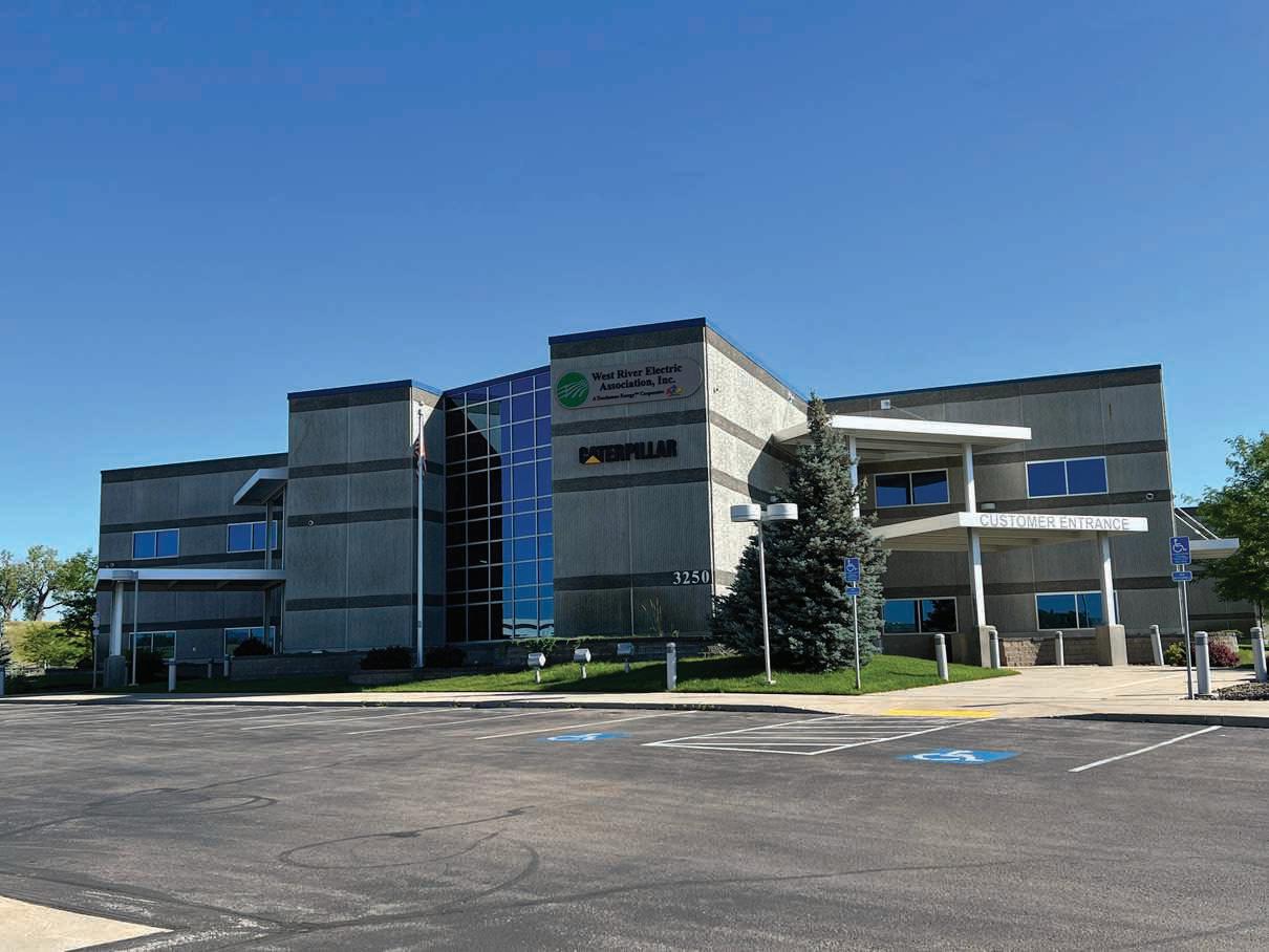
3250 E Hwy 44, Rapid City, SD
Monday-Friday 7 a.m. to 5 p.m.
605-393-1500
1200 W 4th Ave, Wall, SD
Monday-Friday 7 a.m. to 5 p.m.
605-279-2135
A night depository is available at both offices for your convenience.
Contact 605-279-2135 or 605-393-1500 during office hours. E-mail us at info@westriver.coop for questions on your account.
Contact 605-279-2135 or 605-393-1500 in the event of an outage or other emergency. Our calls are answered 24/7.
Bring this coupon and mailing label to the Touchstone Energy® Cooperatives booth at Dakotafest or the South Dakota State Fair to win a prize!
Your Phone Number:
Your E-mail Address:

UNTIL AUG. 10
To have your event listed on this page, send complete information, including date, event, place and contact to your local electric cooperative. Include your name, address and daytime telephone number. Information must be submitted at least eight weeks prior to your event. Please call ahead to confirm date, time and location of event.
AUG. 27-SEPT. 1
South Dakota State Fair Huron, SD
Annual Red Cloud Indian Art Show
Pine Ridge, SD (605) 867-8257
JULY 26
Flower Show
Hill City Center Hill City, SD
JULY 26
South Dakota Chislic Festival 10 a.m.-9 p.m. Freeman, SD www.sdchislicfestival.com
JULY 30-AUG. 3
Fall River County Fair Edgemont, SD
AUG. 1-10
Sturgis Motorcycle Rally Sturgis, SD
AUG. 1-9
Hill City Senior Citizens Biker Breakfast
Hill City Center Hill City, SD
AUG. 3, 9, 17
Mt. Rushmore Rodeo at Palmer Gulch
Palmer Gulch Resort Hill City, SD
AUG. 7-10
Custer County Fair
Custer County Fairgrounds Hermosa, SD
AUG. 9
Moon Walk
Bear Lodge Ranger District
Carson Draw Trail System #87
AUG. 13
Lions Club/Vitalant Blood Drive
Hill City Center Hill City, SD
AUG. 15
Lions Club Bingo Senior Center Hill City, SD
AUG. 15-17
Steam & Gas Threshing Bee 1:30 p.m. parade Fri.-Sun. Sturgis, SD 605-484-9787
AUG. 16
Black Hills Super 6 Mountain Bike Race Big Hills Trails bhsuper6.com
AUG. 16
Boyd’s Antiques Summer Flea Market
AUG. 17, 31
1880 Train Old West Shootout 5 p.m. Hill City, SD
AUG. 24
Sgt. Colton Levi Derr Foundation Barrels, Poles, Breakaway, Team Rope Fundraiser
New Underwood, SD
Facebook: Chase the Ace 605-391-8733
AUG. 26-31
Sturgis Mustang Rally 5 p.m. Hill City, SD
AUG. 30
Lions Club Rubber Duck Race Memorial Park Hill City, SD
AUG. 31
Studebaker & Packard Car & Truck Show
10 a.m.-3 p.m. Custer, SD 605-431-4502
Note: We publish contact information as provided. If no phone number is given, none will be listed. Please call ahead to verify the event is still being held.