
WESTPORTARCHITECTURAL.COM Townhomes Westport Architectural LLC. September 2022 PROJECT JUSTIFICATION REPORT
02 04 08 10 12 16 18 20 20 20 20 Introduction Physical context Proposed development Provencial Policy Statement PPS 2014 Growth Plan for Greater Golden Horseshoe Region of Peel Official Plan City of Brampton Official Plan Arborist report Traffic Impact Assessment study Heritage Impact Assessment study Conclusion Table of Contents Annual Reports 02
TOWN HOUSES, BRAMPTON, ONTARIO.

03 Annual Reports
Introduction
Westport has been retained by the owner to address and assess, from a planning and architectural perspective, a proposed residential development of the lands (“the Subject Site”). The Subject Site is located Southwest of McMurchy, Jessie Street towards the Southwest in the downtown Brampton neighbourhood of Brampton, Ontario. The Subject Site is currently occupied by Single Family Detached house. The property has a driveway from McMurchy South Ave.
An application for Zoning By-law Amendment has been submitted to facilitate the development of four 3-storey rear-lane town homes, with 8 units (“the Proposed Development”). The existing Single Family Detached house will be replaced by the Proposed Development as per the City’s policies. Landscaping is proposed along abutting road. Parking is proposed within the property on the surface in the rear and garage for the residents, with access from a driveway off Jessie Street. The report also provides a summary of the existing zoning context (under City of Brampton Zoning By-laws 438-86 and 569- 2013)

Annual Reports 04
The objective of this report is to examine the planning merits of the Zoning By-law Amendment application to permit the Townhouse development in Brampton, Ontario. The review includes an assessment of the Proposal in regard to its consistency/conformity with the Provincial Policy Statement, 2014, its conformity with the Growth Plan for the Greater Golden Horseshoe, 2017, and its conformity with the City of Brampton Official Plan.
Summary of Findings
The Proposal represents an appropriate form of infill development in the context of the Neighbourhoods designation. In summary, the Proposal:
• Is consistent with the Provincial Policy Statement, 2014 as it represents intensification and efficient development in an existing urban area that is well serviced by existing infrastructure, including transit;
• Conforms to the Growth Plan for the Greater Golden Horseshoe, 2017 as it represents appropriate intensification within a desirable and walk able builtup area;
• Conforms to the City of Brampton Official Plan by providing for appropriate infill development within the Neighborhoods designation that respects and reinforces the existing and emerging character.

• Has appropriate regard for the City’s built form guidelines by providing for the development of a building that appropriately transitions to adjacent neighborhood areas and provides a built form that frames existing public street;
• Provides an improved pedestrian friendly street facade along McMurchy Ave South;
• Can be accommodated by the existing transportation network and proposed parking supply; and
• Can be accommodated by the existing municipal storm sewer and sanitary sewer network. Additional considerations which support the approval of the Proposal are further examined in the report below, and other supporting reports which accompany the application.
05 Annual Reports
Physical Context
Surrounding land uses are varied. Single detached dwellings on properties zoned Residential One (R1) form the vast majority of the uses within a 100 metre radius of the property.
The Memorial Park recreational complex is approximately 200 metres south-east of the property. Curling, baseball, multifunction fields, playgrounds, cycling paths and a community centre are among the existing uses at this complex. The lands are zoned as Institutional Two (I2). To the property’s south are varied light commercial and industrial uses. A large vacant lot on Sheard Avenue is undergoing a zoning by-law amendment to permit 172 townhouse units and is appropriately 260 metres south-east of the property.
McHuge public School is located within close walking distance, to the South of the Subject Site at Elliot St and Craig St Fletcher’s Creek Park runs parallel to McMurchy Avenue South. The park contains environmental protection areas and passive recreational uses. The lands are zoned as Open Space (OS). To the property’s north, running along Queen Street West, properties are primarily zoned Residential One (R1B) or Central Area Mixed-Use (CMU).
Nearly all the properties directly abutting Queen Street West in the vicinity of the property are zoned under these two categories. Several pockets of medium density residential (R3 and above) exist in the areas around the property. Town homes are the predominant uses on these lands. The Subject Site is located within the Forest Hill neighbourhood of North Brampton, an area generally defined as containing a mix of low and medium density residential uses.

Annual Reports 06
The property is approximately 0.1 hectares (960 square metres) in area. There are no known encumbrances, liabilities, easements, or takings currently in force on the property. Approximately 620 square metres (~65%) of the property is soft landscaping. Another 45 square metres (~5%) are covered by driveways and walkways. The remainder is covered by the existing single detached dwelling. The property is lightly vegetated and is predominantly covered by sod. Three mature trees line the Jessie Street lot line. One young tree is immediately east of the existing house along the lot line with 19 Jessie Street. The same lot line is lined with mature hedges. Another three young trees line the lot line with 20 McMurchy Ave South. Miscellaneous small plantings surround the house. The land uses and building types located adjacent to the Subject Site include
:(Northwest: To the immediate northwest across Jessie St are 22 Jessie St and 18 Jessie St which are single family detached houses facing Jessie Street. 22 Jessie Street is a listed Concrete Block house.
Southwest: To the immediate southwest across McMurchy Ave South is 15 McMurchy Ave which is a single family detached house along with 17 McMurchy Ave and 19 McMurchy Ave which are semi detached houses facing McMurchy Ave South.

Northeast: To the immediate northeast is 19 Jessie St a single family detached house facing Jessie Street.
Southeast: To the immediate southeast is 20 McMurchy Ave which is a single family detached house facing McMurchy Ave South.
Municipal roads abut both the front and exterior lot lines. Municipal bus transit is available immediately outside the property on McMurchy Avenue South. The stop serves bus route 52/52A which provides local bus services between Downtown Brampton and the east Churchville area.
BT bus route 52 serves McMurchy Ave South directly adjacent to the Subject Site (with northbound and southbound stops McMurchy Ave South), and bus route 1 is located in proximity to the Subject Site serving Queen Street West. The property is well connected with bicycle track which serves the McMurchy street and Queen Street along with the memorial park.
The Orangeville Brampton Railway line runs diagonally from the north-east to the south-west due south-east of the property. The Orangeville Brampton Railway property does not abut the subject property.
The property is currently serviced by municipal stormwater, water and sanitary systems. The Subject Site is located in an area that is experiencing investment in the housing stock of the neighbourhood
07 Annual Reports
Proposed Develompent
The proposed development requires the redevelopment of the subject property into four 3-storey rear lane townhomes. The townhomes and the rest of the site will be developed in a way which is:

• Massed appropriately
• Transit supportive;
• Appropriate infill;
• Sensitive to surrounding land uses;
• Aesthetically appealing
The proposed build form constitutes appropriate redevelopment that will integrate harmoniously with surrounding land uses. The proposed development will have four 3-storey townhomes, with a combined gross floor area (GFA) of approximately 933.2 square metres. Each townhouse will contain all the spaces as required by the Ontario Building Code and will expand upon them to create a series of high-quality, liveable spaces.
The proposed development will not be mixed use and will be solely supporting residential uses. The front walls of the proposed townhomes will be set back a minimum of 3.05 metres from the McMurchy Avenue South property line. The exterior side lot line setbacks with Jessie Street and the property’s southern neighbour will be 4.33 metres and 1.31 metres respectively. On request from the City of Brampton, front yard treatments may be used to enhance the proposed development front yard.
Access to the proposed townhomes will be provided via private laneway in the subject property’s rear yard. The laneway will be accessed directly from Jessie Street. The laneway will permit full moves access from Jessie Street and is setback as far as possible from the intersection. Each townhome will ultimately be on its own lot. In total, four lots will be created, one for each townhome. Access easements will be registered on title to permit access to the interior townhomes via the private laneway.
A mix of hard and soft landscape elements will be employed to provide an aesthetically-pleasing mix of visual elements, contrast and a welcoming environment which wille enhance the public and private realms and the aesthetic nature of the proposed development and appropriately link the proposed townhomes with the street as well as enable direct, safe and pleasant active transportation connections
Two service areas will exist on the proposed development. The first is a 12 square metre garbage collection area. As per the Region of Peel’s waste collection guidelines, 3 square metres of waste storage space is provided for each townhome. Waste collection is proposed to occur along Jessie Street. Waste collection vehicles are not anticipated to enter the rear access lane. A Canada Post mailbox will also exist in the proposed development. The mailbox will be oriented towards Jessie Street and wholly accessible by the public. The subject property shares lot lines with two municipal roads, Jessie Street and McMurchy Avenue South.
Streetscaping and accompanying urban design elements will seek to enhance the appearance of the property from the public right-of-ways.
Annual Reports 08
Architectural Style
As per the guidelines the proposed structure adopts the architectural character of the forest hill neighbourhood. To preserve the street identity no alterations have been made that indicates a different style on the timeline. The common architectural elements have been borrowed from the street facades to maintain synchrony.
Roofs
Roofs give character to individual buildings and entire city districts. To preserve the street façade, the form of the roof is retained and cladded with wooden shingles which provides a natural and rustic look. It significantly increases the curb appeal of the property and is aesthetically pleasing.
Windows
As per the guide`lines the form and shape of the windows have been restored with distinguishing window details such as materials, frame, surroundings, shutters, sash, muntin and glazing.
Entrance
The style of porches is retained as they are the important elements in defying the character of the building.
Materials and colours
The basement of the subject property is cladded with rusticated concrete blocks acknowledging the listed building (18 Jessie street) opposite to the subject property on the Jessie street. The Upper floor is painted in cream colour to blend in to the neighbourhood.
Massing and height

To preserve the character of the streets the mass and height of the proposed construction does not dominate the exiting context the figure below shows the street elevations post development.
Parking
Three parking spots will be provided for each townhouse unit, for twelve parking spots in total. Access to the parking will be exclusively provided by the rear-lane. Two of each townhome’s parking spaces will be under a landscaped terrace.
On-site parking will be provided so as to accomplish the following objectives:
• To respect adjacent land sues
• Built upon the safety of the public and quasi-public realms
• Provide safe and inviting active transportation routes
• Provide shade and environmental protection
• Manage stormwater and other potential environmental concerns
The proposed construction is positions with favorable walking distance medium density residential high density residential, commercial units, public services, industrial institutional as well as well connected with high order transit services creating a more dynamic environment by ensuring that most people are within a 5 to 10-minute walk of schools, local shops, services, and transit. Retail, commercial and industrial units are positioned along the atrial roads that connect the site.
The proposed town house incorporates environmentally sensitive design with use of Green roofs, and LED lighting Beyond their attractive visual nature, Green Roofs offer many undisputable benefits such as:
• Improve the Microclimate
• Bind Dust and Toxic Particles
• Increase Rainwater Retention
• Improve Noise Protection
• Reduce of Energy Costs
• Protect the Waterproofing
• Offer a Natural Habitat Photometrics will be in accordance with the City of Brampton’s relevant by-laws and will be Dark Sky compliant. This is to ensure that adequate illumination is provided without compromising privacy, utility, or comfort of the proposed development’s future residents.
09 Annual Reports
Provincial Policy Statement
Natural Heritage: The PPS aims to protect environmental features within the natural heritage system. This system can include provincially-significant woodlots, wetlands, habitat for species at risk or any other environmental matters of provincial-significance.
Water: The subject property is located within the Etobicoke Creek Watershed Boundary. Through the preparation of a functional servicing brief, quantity and quality control elements will be recommended to mitigate the potential impacts to water runoff and infiltration.
Agriculture: The property is not located within a primary agricultural area, nor is the lot size suitable for modern agricultural uses. The lands have not been under an agricultural use since at least 1984.
Mineral, Aggregate and Petroleum Resources: The property does not contain any mineral, aggregate or petroleum deposits, nor have any historical extractive processes been undertaken thereon.
Cultural Heritage and Archaeology: The property does not contain any built or culturally significant heritage resources. However, it is proximate to a number of properties listed and designated under the City’s municipal register of cultural heritage resources. The closest of which is the Concrete Block House; the building is a class-B heritage resource and is located at 18 Jessie Street, immediately opposite the subject property. A Heritage Impact Assessment will be provided that will evaluate any potential impacts, if applicable.
Natural Hazards: Since the property is not close to bodies of water, steep slopes, environmentally sensitive areas, or other potentially hazardous environmental features, required natural hazard mitigation measures will largely relate to stormwater management and erosion control.
Human-made Hazards: The proposed development is not on or near to any sites currently or previously affected by mine, oil, gas, salt or aggregate hazards. A Phase 1 ESA and a Record of Site Condition will be submitted concurrently with the applications.

Annual Reports 10
The Provincial Policy Statement (PPS) is the overarching policy document that is intended to provide general direction regarding all matters of Provincial interest. The PPS provides direction on nearly every facet of how planning is undertaken in the Province.
The 2014 PPS governs all applications, matters and proceedings that began on or after April 30th, 2014. All governing provincial and municipal documents must be consistent with the PPS under the previous caveat. Further, all land use planning decisions made under these documents must too be consistent with the PPS.
Efficient Development and Land Use Patterns: Land resources in Ontario are finite. The proposed development makes efficient use of land by maximizing the use of existing, serviced land.
Coordination: Through the iterative planning process, the objectives of all government authorities will be met.
Housing: Demand for diverse land uses in Brampton is ever-growing. Since reliable, aggregate data has been collected (1971), Brampton’s population has been growing significantly faster than employment. This has driven strong demand for new housing, specifically in areas with existing servicing and facilities. The proposed development will be intensifying the number of residential dwellings on the property.
Public Spaces, Recreation, Parks, Trails, and Open Space: The proposed development will not be conveying any land to the City for parkland dedication. Instead, cash-in-lieu of parkland will be provided. The property has excellent access to natural and recreational facilities. The primary entrance to Memorial Park is located 230 metres away from the property, easily within the walkable distance threshold. Further, an entrance to the Fletcher’s Creek trail system is 800 metres away.

Infrastructure and Public Service Facilities: Necessary infrastructure and public service facilities already exist in proximity to the property. This eliminates the need for additional infrastructure or services. Municipal water, sanitary, solid waste and storm servicing is existing, and various public and private services are available nearby.
Multiple transportation options are available near the subject property. Municipal roads and provincial highways provide excellent access to the rest of Brampton, the surrounding municipalities and the province as a whole. Sidewalks and bike trails exist nearby. Several transit routes provide access to Brampton and nearby municipalities.
The property does not abut any provincially significant corridors. The property has not been identified as one necessary to the property requirements of energy transmission or generation infrastructure. The property is within the catchment area for two school boards. See below for enrolment and capacity date.
11 Annual Reports
Growth Plan for the Greater Golden Horseshoe

The Growth Plan for the Greater Golden Horseshoe (The Plan) is a provincial plan created under the authority granted by the Places to Grow Act (2005). The Plan defines a framework to implement the Province’s vision for building stronger, more prosperous communities by better managing growth in the Greater Golden Horseshoe (GGH) to 2041. The Plan guides decisions related to transportation, infrastructure, planning, land-use planning, urban form, housing, natural heritage and resource protection – in the interest of promoting economic prosperity. The Plan provides growth management policy direction for the GGH while working in conjunction with other provincial and municipal policy. The proposed development meets The Plan’s stated goals in a number of ways that will be examined below.
Public Service Facilities: Medical, law enforcement and fire emergency services are all available within a 4-kilometre radius of the property. Fire and medical services are most accessible with the nearest fire station and hospital being 1.4 and 1.6 kilometres away respectively. Government administrative services are also available in proximity to the property. The property, being close to Downtown Brampton, is near a high-density cluster of cultural and artistic services. A modest proportion of Brampton’s public cultural resources are located within less than 1 kilometre of the property.
Annual Reports 12
Integrated Planning: The Plan estimates that up to 30% of infrastructure capital costs and up to 15% of operating costs can be saved through the promotion of intensification and a compact built form. It is in the public interest that these efficiencies be realized whenever possible. While the subject lands are not within the strategic growth area (defined in policy as the urban growth centre), it is immediately adjacent to it. The Plan requires that infrastructure utilization within the strategic growth area be optimized. The concurrently-submitted Functional Servicing Brief will evaluate whether sufficient servicing infrastructure is available to accommodate the proposed development. Further, development charges will be levied, allowing for the funding of infrastructure deficits elsewhere in the City and Region.
Transportation / Moving People and Goods: The property has excellent access to several different transportation networks. Municipal roads and sidewalks provide complete access for motorists, cyclists and pedestrians. Municipal transit is available immediately outside the property. Regional transit is located within walking distance. Nearby trail and pathway networks facilitate active transportation. The property is within an anchor mobility hub, and is considered to be within the catchment area for existing high-order and regional transit. The property will not be generating any freight traffic, nor will it be compromising the integrity of any existing or planned freight routes.
Infrastructure Corridors: The property is not adjacent to any dedicated infrastructure corridors. It is, however, adjacent to municipal roads with existing servicing. Given the Orangeville-Brampton Railway’s current closure, there are no known plans to reconstitute the lands as an infrastructure corridor.
The property is located close to a Potential Rapid Transit Corridor along Queens Street West as defined in the Regional Official Plan.
Water, Wastewater and Stormwater Management Systems: Through the provision of a Functional Servicing Brief, the capacities and utilization rates of the existing water, stormwater and sanitary infrastructure will be evaluated.
The vast majority of future growth must be directed to settlement areas that are: within the delineated built boundary, have existing water / wastewater servicing, and that can support the achievement of complete communities. The proposed development meets all these criteria. The property is within the built boundary. Until 2031, a minimum of 40% of all new residential development must occur within the built boundary. The proposed development contributes to this targe. The proposal will support the achievement of a complete community by:
• Enhancing the supply and variety of housing options
• Intensifying in proximity to existing public and private services
• Intensifying in proximity to multiple centres of employment and transportation
• Accommodating through design people of all ages, abilities and incomes
The property is not within the City’s urban growth centre. The Plan’s stipulations for urban growth centres do not apply.
The property is within the City’s anchor mobility hub but is not, however, within a major transit station or transit corridor. Therefore, the property is not subject to the higher density targets and other related stipulations as defined in The Plan.
The property is not within a designated employment area. No employment uses are proposed. The employment stipulations in The Plan do not apply.
The proposed development will add townhomes to an area dominated by single detached residential dwellings and contributes to housing type mix.
The property is not a designated greenfield. The Plan’s stipulations for greenfield areas therefore do not apply.
The property’s development will not require a settlement area boundary expansion, The Plan’s requirements regarding settlement area expansion are not applicable.
The property is not located within a rural settlement area. The relevant policies of The Plan do not apply.
1.
2.
3.
4.
5.
6.
13 Annual Reports
Public Consultation Strategy
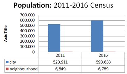
As part of the consultation process, the applicant and project team considered the demographics and population of the local area surrounding the subject site by referring to Statistics Canada census data from the City of Brampton 2016 Neighbourhood Profiles. Overall, this demographic snapshot reveals key highlights of the RidgeHill neighbourhood in comparison to the wider City of Brampton population.
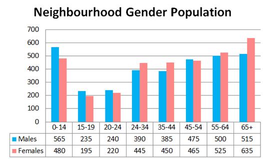

In 2016, Brampton had a total population of 593,638, an increase of 3.3% from the 2011 Census. Brampton ranked 2nd in population growth, between 2011 and 2016 when compared to other municipalities greater than 200,000 in population. At 36.5, Brampton had the lowest average age among Canada’s largest cities. 27.5% of Brampton's population was 19 years and younger and 11.2% was 65 years and older

The home ownership rate in Brampton is 81.7%. The average value of dwellings in Brampton was $570,344 according to Statistics Canada. 48.5% of households in Brampton have 4 or more people whereas it is the average household size for the neighbourhood is 2.90 with 2630 private households in 1252.58sqkms.

24.3% of Brampton's population aged 15 and over completed a University certificate, diploma or degree at a bachelor level or above - an increase from 20.1% in 2011. Business, management, and public administration was the largest post-secondary qualification by major field.
This was followed by Architecture, engineering, and related technologies, and health and related fields. Architecture, engineering, and related technologies was the leading field of study among males. Business, management, and public administration was the main field of choice among females

Annual Reports 14
Based on the context of the neighbourhood and stakeholder groups, the applicant and project team have implemented a series of engagement methods to both inform and consult with community members. Some of these methods are ongoing and may be adjusted based on initial feedback. This list of engagement methods has also taken into consideration the current COVID-19 public health situation, aiming to be flexible in response to up-to-date public health recommendations as well as City Staff’s directions regarding online consultation.
Our initial list of stakeholders is meant to represent those who have been active in the area in regard to other developments, who live close by, and/or represent the area the site is located within.
• Ward Councillor
• City of Brampton - Planning
• Adjacent Neighbours
• Broader Community
• Other Interested Groups/ Individuals
A dedicated project page on social media and email that will serve as an information hub for all stakeholders interested in learning about the project. It provides stakeholders with the opportunity to:
• Learn about the proposal
• Review plans and reports
• Get updates on the status of the project
• Submit comments and ask questions
These communications may come in the form of printed letters, email updates or phone calls. The project team will work with stakeholder groups to establish the most productive and constructive meeting format for those involved.
Brampton’s labour force grew to 319,620 in 2016 from 240,985 in 2006. 10.7% of the total employed workers were selfemployed. 14.6% of the employed labour force was aged 15 to 24 and 14% was aged 55 to 64. Between 2006 and 2016, the number of employed people (15 years and over) in Brampton increased by 30.2% to 293,075.
Brampton residents represented 9.9% of the Toronto CMA labour force, 4.5% of the Ontario labour force and 1.7% of the Canadian labour force Commuting by car and public transit are the most common modes in both the neighbourhood and City overall, while walking and cycling to work is less common in the neighbourhood.


At 14%, public transit was the second most popular method of transportation to work in 2016. Public transit was the method of transportation experiencing the fastest growth between 2001 and 2011, approximately 87% growth compared to cars at 42%.
We recommend that the Scope of Consultation for the proposed development be defined as an area of approximately 200 metres around the subject site, due to the proposal’s scale and significance. This area is in addition to the prescribed minimum notice area of 120 metres, as outlined in the Planning Act. Neighbouring residents along McMurchy South Avenue, Jessie Street and other members of the public may be interested in the proposed development due to their proximity or relationship to the site
Feedback collected through the project website/email, City Planner, Councillor, and other engagement events will inform future iterations of the proposal. The applicant will also continue to work with other stakeholders interested in the development application to understand their feedback and ideas. A summary of all of this feedback can be made available to anyone who is interested, upon request.
15 Annual Reports
Region of Peel Official Plan
2.2.4.1 (1)Promote and participate in watershed plans and sub watershed plans within Peel Region
The property is located within Etobicoke Creek watershed and the Upper Etobicoke Creek sub watershed. The Functional Servicing Brief will evaluate potential watershed impacts and propose mitigation measures, if applicable.
2.2.5.1 (1) Protect, maintain and enhance the integrity of ecosystems through the proper planning and management of groundwater resources and related natural systems in Peel. The subject property is not located within either a wellhead protection or aquifer vulnerability area. Given the property’s location outside of the Oak Ridges Moraine and the Niagara Escarpment plan areas, the lands are of limited concern with regard to groundwater recharge.
2.2.6.1 (3) Protect, maintain and enhance the quality of water resources for the supply of potable water and maintenance of ecosystem integrity in Peel. The property is not located along a river valley or stream corridor nor is it located within the headwater area. Despite this, the property is located within the Etobicoke Creek Watershed, and requires that the quantity and quality of the site’s runoff be adequately controlled.
2.2.7.1 Promote coordinated planning initiatives that recognize, protect, restore and enhance ecosystem integrity in a bioregional context jointly with the area municipalities, conservation authorities, Niagara Escarpment Commission and neighbouring municipalities. The subject property is located within the Greater Toronto Bioregion. The proposed development will, through modern design techniques, preserve the integrity of the Greater Toronto Bioregion.
2.2.8.1 (1) Support the designations and policies of the Niagara Escarpment Plan. Recognize the Oak Ridges Moraine as a provincially significant feature. The subject property is not within the Niagara Escarpment plan area and is not bound by any of the relevant policies. The subject property is not within the Oak Ridges Moraine plan area and is not bound by any of the relevant policies.
2.2.10.2 To implement the Greenbelt Plan through Regional planning documents and decisions in a manner that respects the Five Principles of this Plan, and refined the policies of the Greenbelt Plan to reflect the Regional and local context. To undertake Regional responsibilities in a manner that respects the intent of the Greenbelt Plan.
The subject property is not within the Greenbelt Plan area, and is not bound by any of the relevant policies.
Annual Reports 16
The Regional Greenlands System is composed of linked natural areas. The intent of the ROP is to protect these areas to preserve the integrity of the ecological services they offer. The Regional Greenlands System is composed of Core Areas that are buffered by Natural Areas and Corridors and Potential Natural Areas and Corridors. The Regional Greenlands System provides several non-ecological benefits as well, notably benefits to tourism, business development, employment and contributions to healthy communities. The subject property is not within the Regional Greenlands System, nor does it border any area designated as such. The relevant policies do not apply.
2.4.1.1 To ensure that development and site alterations are not permitted in areas where site conditions or location may pose a danger to public safety, public health or result in property damage.
2.4.1.2 To encourage a coordinated approach to the use of the land and the management of water in areas subject to flooding in order to minimize social disruption.
2.4.1.3 To ensure that methods used to protect existing development at risk from natural hazards, do not negatively impact the integrity of the ecosystem. Natural and human-made hazards lands are divided into two categories: either flood plains or hazard lands. Developments and people may be adversely affected by the characteristics inherent in these lands. The property is not classified as either type of hazard land and is not bound by any of the relevant policies.
2.6.2.1 Support Greenlands securement initiatives in Peel through planning policy, stewardship, monitoring and land acquisition;
2.6.2.5 Support the securement of natural areas through planning policy, stewardship and monitoring before land acquisition is considered.
2.6.2.6 Encourage environmental education to support land stewardship and to promote the value of natural heritage conservation to residents.
The ROP identifies the need for active management, securement and stewardship of the Regional Greenlands System. Stewardship relies on cooperation between both public and private stakeholders to protect, restore and enhance the Region’s environment and resources. While the subject property is neither within or adjacent to any portion of the Regional Greenlands System, the owner is committed to working with the Region in the achievement of its environmental goals.
2.5.1 To seek opportunities to enhance the Greenlands System in Peel by restoring and enhancing degraded components of the ecosystem and by extending the network of natural areas where ecologically beneficial. Human activities have degraded the integrity of Peel’s natural environment. This reduction in integrity has diminished the natural environment’s resilience, and thereby its ability to respond to both natural and human-made stresses. The degradation of the natural environment can be reversed through the restoration of a diminished site. The subject property is not located within the Greenland System. Through the planning process, mitigation measures for any of the proposed development’s potential negative environmental impacts will be proposed. Stormwater quantity and quality control will be evaluated through the Functional Servicing brief.
17 Annual Reports
City of Brampton Officail Plan
4.1 Continue to promote the Central Area and Urban Growth Centre as a prime location for business, shopping, living, dining, entertainment, tourism and cultural activities in the City of Brampton.
The subject property is located within the Central Area designation of the BOP. The BOP identifies a number of objectives for the development within the Central Area. The Central Area is envisioned as a medium to high density place which is attractive, multimodal, has a wide range of land uses, and has access to an equally broad array of public and private services.
The proposed development will contribute to the supply of housing options in the Central Area all while protecting the existing neighborhood and constituting intensification close to public and private services.
4.6 Ensure that land use planning contributes to the protection, improvement and restoration of land and water resources and that all new development, including intensification, shall have a minimum impact on the natural environment.
The BOP aims to be a leader in promoting natural heritage conservation and environmental management with regard to sustainable development. It is recognized that land use and the natural environment are intrinsically linked.
Since the subject property is not located within any Natural Heritage Features or Areas as identified in Schedule D of the BOP, Section 4.6’s policies’ impact on the proposed development is reduced. It is anticipated that any potential negative impacts of the proposed development will be addressed at the Site Plan Application and Building Permit stages of the
The City is comprehensively served by an expansive network of infrastructure and utilities. Said facilities are to be coordinated, constructed in a timely matter and financially sustainable. Insofar as the proposed development, municipal sanitary, water, storm and solid waste services already exist. Despite this, development charges will be paid to finance other public infrastructure projects. Whether additional utility infrastructure will be required to service the proposed development will be determined in the concurrently submitted Functional Servicing Brief.
Schedule F of the BOP identifies the location of existing and anticipated major infrastructure and utility installations.
The subject property is not located on or near any of the identified installations.
Waste Management
In accordance to the region of Peel a curbside collection of garbage, recyclable materials, household organics and yard waste subject to the site meeting the conditions of Sections 2 and 3 of the Waste Collection Design Standards Manual including the following:
Curbside Collection Area
The set out area along the curb, adjacent to the driveway is 3 square metres per unit in order to provide sufficient space for the placement of two carts: maximum 1 large garbage or recycling cart (360 litres) and 1 organics cart (100 litres), overflow waste (i.e. additional bags), yard waste receptacles and bulky items. Each unit within a development must have its own identifiable waste collection point (distinct set).
Annual Reports 18
4.7 Establish a system of parks and recreation facilities that accommodates a wide array of recreational, leisure, cultural and environmentally-focussed opportunities catering to persons of varying abilities and cultural background.
The BOP envisions a comprehensive network of active and passive recreational infrastructure that is available to all regardless of their characteristics. This network will promote healthy, active communities through the safe and equitable provision of public spaces and active transportation infrastructure.
Given the constrained nature of the proposed property, a cashin-lieu of parkland payment is proposed.
The proposed development is in close-proximity to a number of recreational open spaces, namely Fletcher’s Creek and Memorial Park. Said proximity improves the number of residents with good access to such facilities. Pedestrian walkways will provide access to municipal sidewalks, which, in turn, provide access to the City’s many nearby recreation facilities. Private garages will also be provided for each townhouse. The garages will provide storage space for recreational equipment, namely bicycles and other active transportation-enabling devices.
4.9 Ensure the equitable allocation and integration of Institutional and Public Uses throughout the City
The City of Brampton’s rapid growth has increased loads on existing public services and related infrastructure. The proposed development will increase demand for a broad range of services up to but not necessarily limited to social, recreational, educational, public safety, security and protection services. The proposed development’s impacts are anticipated to be minimal given the proposed scale.
4.12 (a) Protect the financial integrity of the City by ensuring that the provision of acceptable levels of service at the lowest possible cost
There is a marginal cost associated with the addition of any given person into the City. It is the BOP’s policy to ensure that costs associated with any given development are recovered on a cost-recovery basis. This is done on the City-level through application fees, cost recovery accounts, development charges, and, ultimately property taxes and user fees.
The appropriate fees, cost recovery payments and/or development charges will be paid by the owner and at the time at which they are required as per the BOP and other relevant policy and legislation.
4.11 (a) Achieve and sustain a physical environmental that is attractive, safe, functionally efficient, sensitive of its evolving character, and environmentally responsible
4.11 (b) Reinforce Brampton’s image as a modern, dynamic, beautiful and liveable city that is built on its rich cultural heritage, including its historical roots as the Flower City, and sustainable, compact and transit-oriented form.
4.11 (c) Promote the Central Area as a transit-oriented and pedestrian friendly destination
4.11 (e) Promote sustainable management practices and green building design standards (such as the principles of Leadership in Energy and Environmental Design (LEED)) which supports a framework for environmentally sustainable development
4.11 (f) Ensure that new development and redevelopment conforms to Brampton’ Development Design Guidelines
Urban design is the conceptualization and design of built forms. The BOP seeks to use urban design as a tool to enhance environmental health and the general well-being of the City’s residents, employees and visitors. Urban design is also specified to act a means to enhance the City’s economic vitality.
An Urban Design Report has been submitted concurrently with this PJR and examines how the City’s and the Province’s various urban design guidelines will be implemented in the proposed development. Broadly, the proposed development will be oriented towards the street, make prominent use of appropriate landscape elements, encourage alternative transportation use and prevent crime.
19 Annual Reports
Supporting Studies
Based on this PJR, Westport is of the opinion that the proposed zoning by-law amendment application constitutes good planning. The amendment will enable the orderly and efficient development of the subject lands and enhance the quality of the area’s built environment. We recommend that all the proposed amendment and eventual consent be granted in full.
As per the guidelines the design adapts the following
The employment level for Brampton is forecast to reach 314,000 jobs by 2031. With new growth, the City depends on its Official Plan to not only direct growth but to also provide the flexibility that is essential for mature neighbourhoods and business parks to adapt in the face of changing economic, social, physical and environmental considerations.
As per proposed BT transit plan the Queen street the IBC’s primary study area is centred on the Queen Street-Highway 7 corridor between Mississauga Road in Brampton in the west to Vaughan Metropolitan Centre in the City of Vaughan in the east. All of the BRT configuration options for the Queen Street-Highway 7 corridor will need to connect into the future Viva BRT Rapidway on Highway 7 west of Pine Valley Drive.
The use of similar architectural elements on the façade, to maintain harmony among the street facades. No specific alterations on the façade that indicates a different period of architectural style.
Use of similar roof pattern and dormers to maintain the chrecter of the street. Addition of chimney creating a balance.
Use of windows with similar architectural style as they are the integral part of the façade.
On facades that face streets, the proportion of a window opening respects the historic proportion of traditional buildings, with a height to- width ratio of 2:1 or more.
On facades that face streets, new window openings respects the traditional ratio of 20% of window-to-wall coverage
Arborist Report: Cinerea Urban Forestry Services was commissioned by Marco Botoletto to complete an Arborist Report and tree protection plan for the proposed construction at 23 Jessie St. Brampton ON. The construction will consist of demolishing the existing house and adding 4 townhouses and a public laneway. An inventory and general health assessment was performed for all trees located within the surveyed area as shown by the supplied drawings.
Tree Replacement Information: Trees #3, 4, 5 are city-owned trees and replacement trees/costs to be determined by the City of Brampton.
Pruning Plan: Bylaw protected, tree # 1, as well as privately-owned trees #6 and 7 will have root pruning within their dripline areas in those areas impacted by construction. See tree protection plan forfurther detail. No above ground pruning is required on any trees that were inventoried to facilitate construction. All root pruning is to be carried out by an ISA Certfied Arborist experienced in this work.
Arborist Recommendations: Removal of trees #3, 4, 5. To Hire ISA Certified Arborist to Airspade and root prune within impacted dripline areas of trees #1, 6, 7. To install tree protection fencing as per the tree protection plan
Construction Notes: No construction materials or debris are to be stored within the Minimum Tree Protection Zones ofany tree as noted on the Tree Protection Plan. All hoarding is to remain in place for duration of the construction. Hoarding is to be removed once construction is completed.
Conclusion: The 3 sugar maple trees on the north side of the property have been recommended to be removed due to their pre-exising condition as well the scale of construction. Trees # 1, 6, 7 are recommended to have AirSpading and root pruning both performed within their dripline area impacted by construction. This is to be performed by an ISA Certified Arborist familiar with these practices. All trees are expected to remain in their current health and structural condition from proposedconstruction.
Annual Reports 20
A Shadow Study has been prepared by Westport Structures Inc. for March 222 and September 22, in accordance with the requirements of the City of Brampton. The study has been prepared to identify incremental shadows cast by the Proposed Development both on its own and in relation to existing buildings in the immediate area. Proposed but not yet approved buildings in the vicinity have not been included in the study. The study indicates that shadows cast by the Proposed Building on neighboring streets, properties and open spaces have been adequately limited in accordance with Official Plan policy.
At no time will the Proposed Building cast any shadow on shadow-sensitive areas (such as parks, schools, cemeteries, etc.), during the time periods and time of year tested in these analyses.
The cumulative effect of the additional shadow cast by the Proposed Development is acceptable and adequately minimizes shadow impacts on neighbouring properties and open spaces, including City streets, in the immediate vicinity. Therefore, the Proposal conforms to the OP policies regarding sunlight access and shadow impact
As specified earlier 18 Jessie street is accommodated with a listed building which is Northwest to the city across Jessie street. Rusticated concrete block (concrete blocks created in a mold which gave them the appearance of rough stone) goes by many other names:
• ornamental concrete block
• decorative block
• cast block
• rock face block
• mold-formed block
• imitation stone
• artificial stone
Popularity
Concrete was prevalent in the structures of Ancient Rome though was not revived until the 19th century. Concrete blocks first appeared in North America in the late 19th century when several companies were granted patents and grants to mass produce concrete blocks. The concrete block making disappeared in the 1890’s when When Portland cement became widely available. The product gained its popularity with inexpensive stone making machinery when Harmon S. Palmer in 1900 designed the first block molding machine.
Function
These concrete blocks served as inexpensive alternative to stone or brick and could be manufactured from readily available raw materials and constructed in regular masonry style. When compared to stone and brick they are stronger, lighter fireproof and convenient.
Rusticated concrete blocks are best suited for American Foursquare style, where the whole house is constructed with these concrete blocks. These were sometimes coloured in white, brown, red or grey. With the change if architectural style the rusticated concrete blocks became a thing of the past. It is often observed on garages and old houses.
Transportation Impact Assessment
As part of a development application, the applicant will need to confirm that there are no plans to create a condominium on this property. A Transportation Impact Assessment (TIA) has been prepared by Westport Structures Inc. in support of the Proposed Development. The TIA evaluates the traffic impacts of the Proposal, the proposed parking and loading, and on-site vehicular movements. The TIA concludes the following:
• The Proposed Development will replace the existing residential land uses on-site with new residential units. A total of 12 units are proposed. The redevelopment of the subject site proposes to maintain the single access to Jessie Street.
• The Subject Site is situated in a walk able area with cycling facilities located nearby. BT (Zum) surface transit services are accessible on the doorstep of the site on the McMurchy Ave South.
• Under existing conditions, McMurchy Ave s/of Jessie St (Stop ID: 1683) serves at capacity during weekday AM peak hour.
• The Proposed Development will satisfy the vehicular parking requirements of the City of Toronto Zoning By-Law.
• The Proposed Development will satisfy the bicycle parking requirements of the City of Toronto Zoning By-Law. As per the City the following gratuitous conveyances for road improvements are accommodated:
• A 7.5 metre daylight triangle at the intersection of McMurchy Avenue and Jessie Street;
• A 2.5 metre conveyance along the entire frontage of Jessie Street; and,
• 2.5 metre conveyance along the entire frontage of McMurchy Avenue.
21 Annual Reports

6810 N State Rd 7, Coconut Creek, FL 33073 (954)257 9189 Email: design@westportarchitectural.com

