

WENTWORTH SHIRE COUNCIL
Notice is hereby given, in accordance with the provisions of the Local Government Act 1993 that an ORDINARY MEETING of Wentworth Shire Council will be held in the WENTWORTH SHIRE COUNCIL CHAMBERS, SHORT STREET, WENTWORTH, commencing at 6:30PM
The meeting is being livestreamed and/or recorded for on-demand viewing via Council’s website. Attendance at the meeting is to be taken as consent by a person to their image and/or voice being webcast.
All speakers should refrain from making any defamatory comments or releasing personal information about another individual without their consent. Council accepts no liability for any damage that may result from defamatory comments made by persons attending meetings –all liability will rest with the individual who made the comments.
The meeting must not be recorded by others without prior written consent of the Council in accordance with the Council’s code of meeting practice
Councillors & staff are obligated to declare Conflicts of Interest as required under the Local Government Act 1993 and Councils adopted Code of Conduct.
Councillors are reminded of their Oath of Office whereby they have declared and affirmed that they will undertake the duties of the Office of Councillor in the best interests of the people of Wentworth Shire and the Wentworth Shire Council and that they will faithfully and impartially carry out the functions, powers, authorities and discretions vested in them under the Local Government Act 1993 or any other Act to the best of their ability and judgment.
KEN ROSS GENERAL MANAGERORDINARY MEETING AGENDA
28 SEPTEMBER 2022
Ordinary Meeting AGENDA 28 September 2022 Page i TABLE OF CONTENTS ITEM SUBJECT PAGE NO 1 OPENING OF MEETING 1 2 PRAYER OR ACKNOWLEDGEMENT OF COUNTRY.......................................... 1 3 APOLOGIES AND APPLICATIONS FOR LEAVE OF ABSENCE........................ 1 4 DISCLOSURES OF INTERESTS 1 5 CONFIRMATION OF MINUTES............................................................................ 1 6 OUTSTANDING MATTERS FROM PREVIOUS MEETINGS .............................. 48 6.1 Outstanding Matters from Previous Meetings 48 7 MAYORAL AND COUNCILLOR REPORTS....................................................... 50 7.1 Mayoral Report 50 8 REPORTS FROM COMMITTEES ....................................................................... 52 Nil 9 REPORTS TO COUNCIL.................................................................................... 53 9.1 General Managers Report 53 9.2 Statutory Meeting Item - Council Meeting Dates and Times 66 9.3 Statutory Meeting Item - Review of Internal Committees........................ 68 9.4 Statutory Meeting Item - Review of External Committees....................... 71 9.5 Disposal of Vacant Land for the Junction Links Development 73 9.6 Union Picnic Day 74 9.7 Christmas Leave Arrangements 76 9.8 Monthly Finance Report 78 9.9 Monthly Investment Report 83 9.10 Wentworth Local Environmental Plan 2011 Rural Land Planning Controls Planning Proposal.................................................................... 89 9.11 NSW Department of Planning and Environment - Agritourism Reforms 164 9.12 Review of Determination DA2021/051 166 9.13 DA2021/050 Stages 1 to 6 (161 Lot Subdivision) of a 262 Lot Subdivision Lot 2 & 3 DP 878007 and Lot 2 DP 1014681 Buronga 177 9.14 Re-Establishement of Alcohol Free Zones 321 9.15 Delegated Authority Approvals as at end of August 2022..................... 326 9.16 Project & Works Update - September 2022.......................................... 329 10 NOTICES OF MOTIONS / QUESTIONS WITH NOTICE................................... 342
Ordinary Meeting AGENDA 28 September 2022 Page ii Nil 11 CONFIDENTIAL BUSINESS – ADJOURNMENT INTO CLOSED SESSION.... 343 12 OPEN COUNCIL - REPORT FROM CLOSED COUNCIL................................. 345 12.1 Plant Replacement - Approval for Tenders for Replacement Plant 504 Specialised Road Maintenance Truck VR2223/504 345 12.2 PT2223/02 - Supply of Bulk Automotive Fuel Tender 346 12.3 Bridge Lift and Maintenance - 12 Month Period PT2021/09 Tender Variation 347 12.4 Project Management of the Wentworth Shire Civic Centre Redevelopment by GSD Architects...................................................... 348 13 CONCLUSION OF THE MEETING ................................................................... 349 NEXT MEETING ............................................................................................................. 349
1
THE MAYOR REQUESTS THAT THE GENERAL MANAGER MAKES ANNOUNCEMENTS REGARDING THE LIVE-STREAMING OF THE MEETING.
5 CONFIRMATION OF MINUTES
Recommendation
That the Minutes of the Ordinary Meeting held 17 August 2022 be confirmed as circulated.
Recommendation
That the Minutes of the Extraordinary Meeting held 12 September 2022 be confirmed as circulated.
Ordinary Meeting AGENDA 28 September 2022 Page 1
OPENING OF MEETING
PRAYER OR ACKNOWLEDGEMENT OF COUNTRY 3 APOLOGIES AND APPLICATIONS FOR LEAVE OF ABSENCE 4 DISCLOSURES OF INTERESTS
2
WENTWORTH SHIRE COUNCIL
ORDINARY MEETING
MINUTES
17 AUGUST 2022
ORDINARY MEETING MINUTES 17 AUGUST 2022 Page 3 Minutes of Ordinary Meeting
17/08/2022
ORDINARY MEETING MINUTES 17 AUGUST 2022 Page 4 Minutes of Ordinary Meeting 17/08/2022 TABLE OF CONTENTS ITEM SUBJECT PAGE NO 1 OPENING OF MEETING 1 2 PRAYER OR ACKNOWLEDGEMENT OF COUNTRY.......................................... 1 3 APOLOGIES AND LEAVE OF ABSENCE............................................................ 1 4 DISCLOSURES OF INTERESTS.......................................................................... 1 5 CONFIRMATION OF MINUTES............................................................................ 1 6 OUTSTANDING MATTERS FROM PREVIOUS MEETINGS ................................ 2 6.1 Outstanding Matters from Previous Meetings 2 7 MAYORAL AND COUNCILLOR REPORTS 4 7.1 Mayoral Report 4 8 REPORTS FROM COMMITTEES ......................................................................... 5 8.1 Audit, Risk and Improvement Committee 5 8.2 Wentworth Showgrounds User Group Meeting 07 July 2022 6 8.3 George Gordon Oval User Group Meeting 13 July 2022 7 8.4 Carramar Drive User Group Meeting 28 June 2022 8 9 REPORTS TO COUNCIL...................................................................................... 9 9.1 General Managers Report........................................................................ 9 9.2 Change of Meeting Date 10 9.3 Local Government Representative Willandra Lakes World Hertiage Advsiory Committee 11 9.4 Council Branding 12 9.5 Monthly Finance Report 13 9.6 Monthly Investment Report 14 9.7 June Quarterly Budget Review............................................................... 15 9.8 Delivery Program Progress Update........................................................ 16 9.9 AF003 Requests for Financial Assistance 17 9.10 DA2022/061 Increasing weekly production of existing rural industry from 700 tonne to 4200 tonne 28 Jindalee Road and 623 River Road Lot 1 DP 1264484 and Lot 989 DP 759961 Coomealla 18 9.11 Wentworth Local Environmental Plan 2011 – Thegoa Lagoon Rezoning Planning Proposal 19 9.12 Health and Planning - Request for Policy Adoption................................ 20 9.13 Council stormwater infrastructure on 191 Pitman Avenue Buronga........ 21 9.14 Delegated Authority Approvals as at end of July 2022 22
ORDINARY MEETING MINUTES 17 AUGUST 2022 Page 5 Minutes of Ordinary Meeting 17/08/2022 9.15 Project & Works Update - August 2022 23 10 NOTICES OF MOTIONS / QUESTIONS WITH NOTICE..................................... 24 10.1 Funding for Australian Inland Botanic Gardens 24 11 CONFIDENTIAL BUSINESS – ADJOURNMENT INTO CLOSED SESSION 25 12 OPEN COUNCIL - REPORT FROM CLOSED COUNCIL................................... 27 12.1 Old Wentworth Road - Variation for Supply and Delivery of Road Base Material - PT2122/13..................................................................... 27 13 CONCLUSION OF THE MEETING ..................................................................... 28 NEXT MEETING 28
1 OPENING OF MEETING
The Mayor opened the meeting with a prayer at 6:30pm.
2 PRAYER OR ACKNOWLEDGEMENT OF COUNTRY
PRESENT:
COUNCILLORS:
Councillor Tim Elstone
Councillor Brian Beaumont
Councillor Steve Cooper
Councillor Peter Crisp
Councillor Steve Heywood
Councillor Daniel Linklater
Councillor Jane MacAllister
Councillor Jo Rodda
STAFF:
Ken Ross (General Manager)
Matthew Carlin (Director Health and Planning)
Geoff Gunn (Director Roads and Engineering)
Simon Rule (Director Finance and Policy)
Gayle Marsden (Executive Assistant to General Manager)
3 APOLOGIES AND LEAVE OF ABSENCE
Council Resolution
That Council notes the apologies and grants the Leave of Absence Request from Cr Susan Nichols.
Moved Cr. MacAllister, Seconded Cr Cooper
4 DISCLOSURES OF INTERESTS
Councillor Beaumont advised that he had a less than significant pecuniary interest in Item 9.9 as he is a member of the Wentworth Racing Club and Wentworth District Community Medical Centre Inc.
Councillor Rodda advised that he had a less than significant pecuniary interest in Item 9.10 as she had prior knowledge of the proposal before the matter has come to council.
Councillor Heywood advised that he had a significant pecuniary interest in Item 9.10 as his son is a contractor to the business.
Councillor Linklater advised that he had a less than significant pecuniary interest in Item 9.14 as his sister in law is an applicant in the delegated authority report.
ORDINARY MEETING MINUTES 17 AUGUST 2022 Page 6 Minutes of Ordinary Meeting 17/08/2022
CARRIED UNANIMOUSLY
5 CONFIRMATION OF MINUTES
Recommendation
That the Minutes of the Ordinary Meeting held 20 July 2022 be confirmed as circulated.
Council Resolution
That the Minutes of the Ordinary Meeting held 20 July 2022 be confirmed as circulated.
Moved Cr Rodda, Seconded Cr. Heywood
Council Resolution
That the Ordinary Council meeting be adjourned for the purpose of conducting a Public Forum.
The meeting was adjourned at 6:36pm
Moved Cr Linklater, Seconded Cr. Crisp
Mrs Glenis Beaumont spoke to Item 9.9
Mr Doug Alvey spoke to against Item 9.10
Mr James Golsworthy spoke in favour of Item 9.10
Council Resolution
That Council reconvenes into open session.
Moved Cr Linklater, Seconded Cr Crisp CARRIED UNANIMOUSLY
ORDINARY MEETING MINUTES 17 AUGUST 2022 Page 7 Minutes of Ordinary Meeting 17/08/2022
CARRIED UNANIMOUSLY
CARRIED UNANIMOUSLY
6 OUTSTANDING MATTERS FROM PREVIOUS MEETINGS
6.1 OUTSTANDING MATTERS FROM PREVIOUS MEETINGS
File Number: RPT/22/457
Responsible Officer: Ken Ross - General Manager
Responsible Division: Office of the General Manager
Reporting Officer: Gayle Marsden - Executive Assistant
Objective: 4.0 Wentworth Shire is supported by strong and ethical civic leadership with all activities conducted in an open, transparent and inclusive manner
Strategy: 4.2 A strong, responsible and representative government
Summary
The Outstanding Actions report provides details of activities raised at previous Council meetings that remain outstanding.
Officer Recommendation
That Council receives and notes the list of outstanding matters as at 9 August 2022. Council Resolution
That Council receives and notes the list of outstanding matters as at 9 August 2022. Moved Cr Crisp, Seconded Cr Rodda
ORDINARY MEETING MINUTES 17 AUGUST 2022 Page 8 Minutes of Ordinary Meeting 17/08/2022
CARRIED UNANIMOUSLY
7 MAYORAL AND COUNCILLOR REPORTS
7.1 MAYORAL REPORT
File Number: RPT/22/456
Recommendation
That Council receives and notes the information contained in the Mayoral report.
Council Resolution
That Council receives and notes the information contained in the Mayoral report.
Moved Cr. Elstone , Seconded Cr Linklater
ORDINARY MEETING MINUTES 17 AUGUST 2022 Page 9 Minutes of Ordinary Meeting
17/08/2022
CARRIED UNANIMOUSLY
8 REPORTS FROM COMMITTEES
8.1 AUDIT, RISK AND IMPROVEMENT COMMITTEE
File Number: RPT/22/514
Responsible Officer: Simon Rule - Director Finance and Policy
Responsible Division: Finance and Policy
Reporting Officer: Simon Rule - Director Finance and Policy
Objective: 4.0 Wentworth Shire is supported by strong and ethical civic leadership with all activities conducted in an open, transparent and inclusive manner
Strategy: 4.2 A strong, responsible and representative government
Summary
A meeting of the Audit, Risk and Improvement Committee was held on 26 July 2022 and the draft Minutes of the meeting are attached to this report for the information of Councillors.
The Committee considered the following items of business:
• Committee Induction and Overview
• Annual Audit Engagement Plan and Interim Audit
• Review of the OLG Guidelines for the Committee
• Review of the Committee Terms of Reference
• Future Committee Meeting Schedule and Agenda Format
• 2022-2023 Committee Workplan
The Committee has requested that the Reporting Officer seek a resolution of Council on the following item:
• Review of the Committee Terms of Reference
Officer Recommendation
That Council note the draft minutes of the Audit, Risk and Improvement Committee; and That Council approves the Terms of Reference for the Audit, Risk and Improvement Committee.
Council Resolution
That Council
a) Receive and note the draft minutes of the Audit, Risk and Improvement Committee; and
b) Approves the Terms of Reference for the Audit, Risk and Improvement Committee. Moved Cr. Crisp, Seconded Cr. Heywood
ORDINARY MEETING MINUTES 17 AUGUST 2022 Page 10 Minutes of Ordinary Meeting 17/08/2022
Council Resolution
Amendment
That Council
a) Receive and note the draft minutes of the Audit, Risk and Improvement Committee; and
b) Approve the Terms of Reference for the Audit, Risk and Improvement Committee with amendments as described
c) Schedules an external review of the effectiveness of the Committee to be completed by the end of August 2023
Cr. MacAllister, Seconded Cr. HeywoodUNANIMOUSLY
ORDINARY MEETING MINUTES 17 AUGUST 2022 Page 11
of Ordinary Meeting
Minutes
17/08/2022
Moved
CARRIED
8.2 WENTWORTH SHOWGROUNDS USER GROUP MEETING 07 JULY 2022
File Number: RPT/22/472
Responsible Officer: Geoff Gunn - Director Roads and Engineering
Responsible Division: Roads and Engineering
Reporting Officer: Chanelle Pilling - Administration Officer
Objective:
Strategy:
3.0 Wentworth is a community that works to enhance and protect its physical and natural environment
3.2 Ensure that community assets and public infrastructure are well maintained
Summary
A meeting of the Wentworth Showgrounds User Group was held on 07 July 2022 and the Minutes of the meeting are attached to this report for the information of Councillors.
Officer Recommendation
That Council receives and notes the report.
Council Resolution
That Council receives and notes the report.
Moved Cr Rodda, Seconded Cr Cooper
ORDINARY MEETING MINUTES 17 AUGUST 2022 Page 12 Minutes of Ordinary Meeting 17/08/2022
CARRIED UNANIMOUSLY
8.3 GEORGE GORDON OVAL USER GROUP MEETING 13 JULY 2022
File Number: RPT/22/482
Responsible Officer: Geoff Gunn - Director Roads and Engineering
Responsible Division: Roads and Engineering
Reporting Officer: Chanelle Pilling - Administration Officer
Objective:
3.0 Wentworth is a community that works to enhance and protect its physical and natural environment
Strategy: 3.2 Ensure that community assets and public infrastructure are well maintained
Summary
A meeting of the George Gordon Oval User Group was held on 13 July 2022 and the Minutes of the meeting are attached to this report for the information of Councillors.
Officer Recommendation
That Council receives and notes the report.
Council Resolution
That Council receives and notes the report.
Moved Cr Crisp, Seconded Cr Cooper CARRIED
ORDINARY MEETING MINUTES 17 AUGUST 2022 Page 13 Minutes of Ordinary Meeting 17/08/2022
UNANIMOUSLY
8.4 CARRAMAR DRIVE USER GROUP MEETING 28 JUNE 2022
File Number: RPT/22/483
Responsible Officer: Geoff Gunn - Director Roads and Engineering
Responsible Division: Roads and Engineering Reporting Officer: Chanelle Pilling - Administration Officer
Objective:
3.0 Wentworth is a community that works to enhance and protect its physical and natural environment
Strategy: 3.2 Ensure that community assets and public infrastructure are well maintained
Summary
A meeting of the Carramar Drive User Group was held on 28 June 2022 and the Minutes of the meeting are attached to this report for the information of Councillors.
Officer Recommendation
That Council receives and notes the report.
Council Resolution
That Council receives and notes the report.
Moved Cr Rodda, Seconded Cr Cooper CARRIED
ORDINARY MEETING MINUTES 17 AUGUST 2022 Page 14 Minutes of Ordinary Meeting 17/08/2022
UNANIMOUSLY
9 REPORTS TO COUNCIL
9.1 GENERAL MANAGERS REPORT
File Number: RPT/22/458
Responsible Officer: Ken Ross - General Manager
Responsible Division: Office of the General Manager
Reporting Officer: Gayle Marsden - Executive Assistant
Objective: 4.0 Wentworth Shire is supported by strong and ethical civic leadership with all activities conducted in an open, transparent and inclusive manner
Strategy: 4.2 A strong, responsible and representative government
Summary
The General Manager’s report details information pertaining to meetings attended and general information which are of public interest, and which have not been reported elsewhere in this agenda. Items of note in this report are:
1. OLG Circulars
Circular 22-19 to 22-21
2. Meetings As listed
3. Upcoming meetings or events As listed
4. Other items of note
Recommendation
That Council receives and notes the information contained within the report from the General Manager.
Council Resolution
That Council receives and notes the information contained within the report from the General Manager.
ORDINARY MEETING MINUTES 17 AUGUST 2022 Page 15 Minutes of Ordinary Meeting
17/08/2022
UNANIMOUSLY
Moved Cr Rodda, Seconded Cr Beaumont CARRIED
9.2 CHANGE OF MEETING DATE
File Number: RPT/22/509
Responsible Officer: Ken Ross - General Manager
Responsible Division: Office of the General Manager
Reporting Officer: Gayle Marsden - Executive Assistant
Objective:
4.0 Wentworth Shire is supported by strong and ethical civic leadership with all activities conducted in an open, transparent and inclusive manner
Strategy: 4.3 An effective and efficient organisation
Summary
The Murray Darling Association Annual Conference and Annual General Meeting are being held on 19-21 September 2022. The September 2022 Ordinary Council meeting is scheduled for the 21 September 2022. Due to three Councillors attending the Conference it is proposed that the Ordinary Council meeting scheduled for 21 September 2022 be rescheduled to be held on 28 September 2022.
Recommendation
That the Ordinary Council meeting scheduled for 21 September 2022 be rescheduled to be held at the Wentworth Shire Council Chambers at 6:30pm on 28 September 2022.
Council Resolution
That Council resolves:
a) That the Ordinary Council meeting scheduled for 21 September 2022 be rescheduled to be held at the Wentworth Shire Council Chambers at 6:30pm on 28 September 2022 and
b) Due to the timeframes for applications for the Stronger Country Communities Funding, the Resources for Regions funding and the Local Roads and Community Infrastructure funding an Extraordinary meeting be called for the 12 September 2022 to be held at the Wentworth Shire Council Chambers at 6:30pm to determine funding priorities.
ORDINARY MEETING MINUTES 17 AUGUST 2022 Page 16 Minutes of Ordinary Meeting 17/08/2022
CARRIED UNANIMOUSLY
Moved Cr. Heywood, Seconded Cr Rodda
9.3 LOCAL GOVERNMENT REPRESENTATIVE WILLANDRA LAKES WORLD HERTIAGE ADVSIORY COMMITTEE
File Number: RPT/22/510
Responsible Officer: Ken Ross - General Manager
Responsible Division: Office of the General Manager
Reporting Officer: Gayle Marsden - Executive Assistant
Objective: 4.0 Wentworth Shire is supported by strong and ethical civic leadership with all activities conducted in an open, transparent and inclusive manner
Strategy: 4.2 A strong, responsible and representative government
Summary
At the 20 April 2022 Ordinary Council meeting Council resolved to nominate Cr Nichols & Cr Beaumont to apply to be the Local Government representatives on the Willandra Lakes World Heritage Area Advisory Committee. Cr MacAllister who was formerly on the Committee has requested she be able to nominate as well. Cr MacAllister’s inclusion requires a resolution of Council.
Recommendation
That Council endorse Cr MacAllister to apply to be a Local Government representative on the Willandra Lakes World Heritage Area Advisory Committee
Council Resolution
That Council endorse Cr MacAllister to apply to be a Local Government representative on the Willandra Lakes World Heritage Area Advisory Committee
Moved Cr. MacAllister, Seconded Cr. Heywood
ORDINARY MEETING MINUTES 17 AUGUST 2022 Page 17 Minutes of Ordinary Meeting 17/08/2022
CARRIED UNANIMOUSLY
9.4 COUNCIL BRANDING
File Number: RPT/22/460
Responsible Officer: Ken Ross - General Manager
Responsible Division: Office of the General Manager
Reporting Officer: Lexi Stockman - Manager Tourism and Promotion
Objective:
4.0 Wentworth Shire is supported by strong and ethical civic leadership with all activities conducted in an open, transparent and inclusive manner
Strategy: 4.4 Provide strong leadership and work in partnership to strategically plan for the future
Summary
With the move into the Civic Centre planned within the next 18 months, the timing of the rebranding is imperative to Council’s fresh start within a new building, combining all operational areas of Council including the Council Offices, Visitor Information Centre, Library and Conference Centre.
Council has engaged Saunders Design to develop new branding in anticipation for our move to the Civic Centre and in line with our new tourism branding. Extensive research has been undertaken to develop the branding including a new council logo to highlight the Shire’s best assets. Council had previewed the work to date during an information session conducted by Saunders Design on 22 June 2022.
Recommendation
That Council endorse the Saunders Design branding proposal and progress the development of the custom style guideline previously presented to Council.
Council Resolution
That Council endorse the Saunders Design branding proposal and progress the development of the custom style guideline previously presented to Council.
Moved Cr Rodda, Seconded Cr Linklater
ORDINARY MEETING MINUTES 17 AUGUST 2022 Page 18 Minutes of Ordinary Meeting 17/08/2022
CARRIED UNANIMOUSLY
9.5 MONTHLY FINANCE REPORT
File Number: RPT/22/489
Responsible Officer: Simon Rule - Director Finance and Policy
Responsible Division: Finance and Policy Reporting Officer: Vanessa Lock - Finance Officer
Objective:
4.0 Wentworth is a caring , supportive and inclusive community that is informed and engaged in its future Strategy: 4.1 Provide strong and effective representation, leadership, planning, decision-making and service delivery
Summary
Rates and Charges collections for the month of July 2022 were $ 621,292.19. After allowing for pensioner subsidies, the total levies collected are now 6.95%. For comparison purposes 8.27% of the levy had been collected at the end of July 2021. Council currently has $42,090,756.10 in cash and investments.
Recommendation
That Council receives and notes the Monthly Finance Report.
Council Resolution
That Council receives and notes the Monthly Finance Report. Moved Cr Linklater, Seconded Cr Beaumont CARRIED UNANIMOUSLY
ORDINARY MEETING MINUTES 17 AUGUST 2022 Page 19 Minutes of Ordinary Meeting 17/08/2022
9.6 MONTHLY INVESTMENT REPORT
File Number: RPT/22/461
Responsible Officer: Simon Rule - Director Finance and Policy
Responsible Division: Finance and Policy Reporting Officer: Bryce Watson - Accountant
Objective: 4.0 Wentworth Shire is supported by strong and ethical civic leadership with all activities conducted in an open, transparent and inclusive manner
Strategy: 4.5 Adopt practices of prudent asset, financial and human resource management across Council to ensure long-term sustainability and efficiency
Summary
As at 31 July 2022 Council had $37 million invested in term deposits and $5,090,756.10 in other cash investments. Council received $12,520.03 from its investments for the month of July 2022.
In July 2022 Council investments averaged a rate of return of 1.59% and it currently has $8,440,396.07 of internal restrictions and $22,917,683.58 of external restrictions.
Recommendation
That Council receives and notes the monthly investment report.
Council Resolution
That Council receives and notes the monthly investment report.
Moved Cr Crisp, Seconded Cr Rodda
ORDINARY MEETING MINUTES 17 AUGUST 2022 Page 20 Minutes of Ordinary Meeting 17/08/2022
CARRIED UNANIMOUSLY
9.7 JUNE QUARTERLY BUDGET REVIEW
File Number: RPT/22/462
Responsible Officer: Simon Rule - Director Finance and Policy
Responsible Division: Finance and Policy
Reporting Officer: Bryce Watson - Accountant
Objective:
4.0 Wentworth Shire is supported by strong and ethical civic leadership with all activities conducted in an open, transparent and inclusive manner
Strategy: 4.5 Adopt practices of prudent asset, financial and human resource management across Council to ensure long-term sustainability and efficiency
Summary
A full analysis of Council’s Income, Operating Expenditure and Capital Expenditure has been undertaken. A number of variations have been identified against the original budget as outlined in this report. Council’s revenue and expenditure is reviewed on a quarterly basis to identify any potential areas requiring a variation.
If approved, the net result of variances for the June 2022 Quarter is a favorable operational variance of $1,952,000 and a favorable capital variance of $4,103,000 resulting in a total favorable budget variation of $6,055,000.
Recommendation
That Council approves the variations to the 2021/22 Operational Plan adopted at the 30 June 2021 Ordinary Council Meeting.
Council Resolution
That Council approves the variations to the 2021/22 Operational Plan adopted at the 30 June 2021 Ordinary Council Meeting.
Moved Cr Crisp, Seconded Cr. Heywood
ORDINARY MEETING MINUTES 17 AUGUST 2022 Page 21 Minutes of Ordinary Meeting 17/08/2022
YTD Actual
% of Original Budget % of Revised Budget Revenue $39,099,641 95.75% 93.10% Operational Expenditure $26,012,133 102.89% 93.09% Capital Expenditure $15,212,156 50.72% 65.94%
(30-JUN-22)
CARRIED UNANIMOUSLY
9.8 DELIVERY PROGRAM PROGRESS UPDATE
File Number: RPT/22/467
Responsible Officer: Simon Rule - Director Finance and Policy
Responsible Division: Finance and Policy Reporting Officer: Bryce Watson - Accountant
Objective:
4.0 Wentworth Shire is supported by strong and ethical civic leadership with all activities conducted in an open, transparent and inclusive manner
Strategy: 4.5 Adopt practices of prudent asset, financial and human resource management across Council to ensure long-term sustainability and efficiency
Summary
A progress report on the implementation of Council’s 4-year Delivery program is required to be presented at least every six (6) months (LGA s404(5)). This report details the activities implemented under the annual operational plan in the last quarter, as per the Delivery program. It aligns with the expenditure provided in the June Quarterly Budget Review.
This report utilises delivery program objectives from the 2017-2022 delivery program. The new delivery program adopted by council on 29 June 2022will be utilised from 1 July 2022.
Recommendation
That Council receives and notes the quarterly progress update on the 2021/22 Operational Plan activities.
Council Resolution
That Council receives and notes the quarterly progress update on the 2021/22 Operational Plan activities.
Moved Cr Linklater, Seconded Cr Cooper
ORDINARY MEETING MINUTES 17 AUGUST 2022 Page 22 Minutes of Ordinary Meeting 17/08/2022
CARRIED UNANIMOUSLY
9.9 AF003 REQUESTS FOR FINANCIAL ASSISTANCE
File Number: RPT/22/480
Responsible Officer: Simon Rule - Director Finance and Policy
Responsible Division: Finance and Policy Reporting Officer: Annette Fraser - Team Leader Customer Service
Objective: 2.0 Wentworth Shire is a great place to live Strategy: 2.4 A well informed, supported and engaged community
Summary
Council has provided an allocation of $160,000.00 for the 2022/23 financial year for consideration by Council, for the funding of requests from the community for financial assistance. In this financial year, $104,320.00 has been granted to a variety of organisations through the annual fees and charges “Exemptions from the Application” process.
The total value of requests granted so far under delegated authority is $739.00. The total value of requests for this August 2022 funding application period totals $27,040.11, which if granted in full would leave a balance in the financial assistance program of $27,900.89.
Councillor MacAllister requested that the first four requests be considered prior to Councillor Beaumont leaving the Chambers.
Recommendation
That Council having considered the current requests for financial assistance, makes appropriate recommendations on the level of funding to be provided to each of these applications from the Financial Assistance program.
Council Resolution
That Council grant $5000 to the Dareton Kennel Club Inc, $5000 to the Wentworth Show Society, $5000 to the RFDS Operation Pelican Inc and $4996.50 to the Gol Gol Preschool Association Corporation
Moved Cr. MacAllister, Seconded Cr Cooper
At 07:50 pm Councillor Brian Beaumont left the Council Chambers.
Council Resolution
That Council grants funding of $4,466 to the Wentworth District Racing Club and a rate reduction of 25% to the Wentworth District Community Medical Centre Inc and funding of $2100 to the Wentworth District Community Medical Centre Inc
Moved Cr Rodda, Seconded Cr. Heywood
Council Resolution
At 07:55 pm Councillor Brian Beaumont returned to Council Chambers.
ORDINARY MEETING MINUTES 17 AUGUST 2022 Page 23 Minutes of Ordinary Meeting 17/08/2022
CARRIED UNANIMOUSLY
CARRIED UNANIMOUSLY
9.10 DA2022/061 INCREASING WEEKLY PRODUCTION OF EXISTING RURAL INDUSTRY FROM 700 TONNE TO 4200 TONNE 28 JINDALEE ROAD AND 623 RIVER ROAD LOT 1 DP 1264484 AND LOT 989 DP 759961 COOMEALLA
File Number: RPT/22/498
Responsible Officer: Matthew Carlin - Director Health and Planning Responsible Division: Health and Planning Reporting Officer: George Kenende - Development Assessment Officer
Objective: 1.0 Wentworth Shire is a vibrant, growing and thriving Region Strategy: 1.1 Promote the Shire as an ideal location for investment and the establishment of innovative, sustainable and diversified industries
At 07:52 pm Councillor Steve Heywood left the Council Chambers.
At 07:52 pm Councillor Jo Rodda left the Council Chambers.
Summary
Recommendation
1. That Council approve DA2022/061 being increasing the weekly production of an existing rural industry from 700 tonne to 4200 tonne be located at 28 Jindalee Road & 623 River Road, Lot 1 DP 1264484 & Lot 989 DP 759961 Coomealla.
2. Call a division in accordance with S375A of the Local Government Act 1993 (NSW)
Council Resolution
That Council
a) Approve DA2022/061 being increasing the weekly production of an existing rural industry from 700 tonne to 4200 tonne be located at 28 Jindalee Road & 623 River Road, Lot 1 DP 1264484 & Lot 989 DP 759961 Coomealla.
b) Call a division in accordance with S375A of the Local Government Act 1993 (NSW)
Moved Cr. Linklater, Seconded Cr Cooper
Council Resolution
Amendment
That Council
a) Approve DA2022/061 being increasing the weekly production of an existing rural industry from 700 tonne to 4200 tonne be located at 28 Jindalee Road & 623 River Road, Lot 1 DP 1264484 & Lot 989 DP 759961 Coomealla.
b) Add a condition that the proponent provide a marc management plan
c) Modify Condition 6 to be amended to include “provide Council with weighbridge ticket receipts”
d) Call a division in accordance with S375A of the Local Government Act 1993 (NSW)
Moved Cr Crisp, Seconded Cr Cooper
ORDINARY MEETING MINUTES 17 AUGUST 2022 Page 24 Minutes of Ordinary Meeting 17/08/2022
CARRIED UNANIMOUSLY
In accordance with Section 375A of the Local Government Act the Mayor called for a division.
For the Motion : Clr.s Beaumont, Cooper, Crisp, Elstone (Mayor) and Linklater.
Against the Motion: Clr. MacAllister.
At 08:02 pm Councillor Steve Heywood returned to Council Chambers. At 08:02 pm Councillor Jo Rodda returned to Council Chambers.
ORDINARY MEETING MINUTES 17 AUGUST 2022 Page 25
of Ordinary Meeting
Minutes
17/08/2022
9.11 WENTWORTH LOCAL ENVIRONMENTAL PLAN 2011 – THEGOA LAGOON REZONING PLANNING PROPOSAL
File Number: RPT/22/492
Responsible Officer: Matthew Carlin - Director Health and Planning Responsible Division: Health and Planning Reporting Officer: George Kenende - Development Assessment Officer
Objective: 3.0 Wentworth is a community that works to enhance and protect its physical and natural environment Strategy: 3.3 Minimise the impact on the natural environment
Summary
Council resolved to support this Planning Proposal at its Ordinary Meeting held 16 February 2022. Following that resolution, the Planning Proposal was lodged with the Department of Planning and Environmental (DPE) for a gateway determination.
A Gateway Determination to proceed was issued by the Department of Planning and Environment (DPE) on 4 April 2022 to rezone Thegoa Lagoon Reserve and waterway from RU1 Primary Production & RU5 Village zone with a minimum lot size of 10,000 hectares to C2 Environmental Conservation zone with no minimum lot sizes.
Public exhibition and state agency consultation has been conducted in accordance with Conditions 2 and 3 of the Gateway Determination. Five (5) submissions were received from state agencies, with none of them being objections. One joint submission was received from of the notified adjoining land owners, with the submission being an objection.
The report also advises that in accordance with Condition 5 of the Gateway Determination, Council is authorised to act as the local plan-making authority.
Council is the Local plan-making authority for the Planning proposal including its finalisation. However, council will be requesting DPE to prepare the final mapping.
Recommendation
That Council
a) As the plan-making authority, resolve to proceed with the finalisation of the Planning Proposal as per section 3.36 of the Environmental Planning and Assessment Act 1979
b) Call a division in accordance with S375A of the Local Government Act 1993 (NSW).
Council Resolution
That Council:
a) As the plan-making authority, resolve to proceed with the finalisation of the Planning Proposal as per section 3.36 of the Environmental Planning and Assessment Act 1979
b) Call a division in accordance with S375A of the Local Government Act 1993 (NSW).
Moved Cr. MacAllister, Seconded Cr Crisp
In accordance with Section 375A of the Local Government Act the Mayor called for a division.
ORDINARY MEETING MINUTES 17 AUGUST 2022 Page 26 Minutes of Ordinary Meeting 17/08/2022
CARRIED UNANIMOUSLY
For the Motion : Clr.s Beaumont, Cooper, Crisp, Elstone (Mayor), Heywood, Linklater, MacAllister and Rodda.
Against the Motion: Nil.
17/08/2022
ORDINARY MEETING MINUTES 17 AUGUST 2022 Page 27
of Ordinary Meeting
Minutes
9.12 HEALTH AND PLANNING - REQUEST FOR POLICY ADOPTION
File Number: RPT/22/493
Responsible Officer: Matthew Carlin - Director Health and Planning
Responsible Division: Health and Planning
Reporting Officer: Matthew Carlin - Director Health and Planning
Objective: 4.0 Wentworth Shire is supported by strong and ethical civic leadership with all activities conducted in an open, transparent and inclusive manner
Strategy: 4.1 Consistently engage and consult the whole community to ensure that feedback is captured and considered as part of decision-making and advocating processes
Summary
After each general election of Councillors, the Local Government Act 1993 (the Act) requires Council to review all official policies of Council. There are currently 73 policies in place of which 15 are the responsibility of the Health and Planning Department.
Health and Planning undertook public exhibition of two policies for 28 days in accordance with Councils Community Participation Plan; and there being no submissions received, these policies are now presented for adoption
Recommendation
That Council, following the completion of the public exhibition period and there being no submissions, adopt the following draft policies:
a) PR008 Compliance and Enforcement Policy
b) PR015 Keeping of Animals at Residential Properties
Council Resolution
That Council following the completion of the public exhibition period and there being no submissions, adopt the following draft policies:
a) PR008 Compliance and Enforcement Policy
b) PR015 Keeping of Animals at Residential Properties
Moved Cr. Rodda, Seconded Cr. Cooper
ORDINARY MEETING MINUTES 17 AUGUST 2022 Page 28 Minutes of Ordinary Meeting 17/08/2022
UNANIMOUSLY
CARRIED
9.13 COUNCIL STORMWATER INFRASTRUCTURE ON 191 PITMAN AVENUE BURONGA
File Number: RPT/22/415
Responsible Officer: Matthew Carlin - Director Health and Planning
Responsible Division: Health and Planning Reporting Officer: Michele Bos - Strategic Development Officer
Objective: 3.0 Wentworth is a community that works to enhance and protect its physical and natural assets Strategy: 3.2 Plan for and develop the right assets and infrastructure
Summary
Council has received a planning proposal from Roy Costa Planning & Development seeking to rezone 191 Pitman Avenue Buronga from RU1 Primary Production zone to RU5 Village zone and remove the 10 hectare minimum lot size.
A previous report to Council in January, seeking to waive the LEP amendment fee of $6,367.00, was refused. The proponent has now paid the applicable fee.
However, to enable the planning proposal to proceed to the next stage, being lodgement on the planning portal and an assessment of the merits and justification for the rezoning, Council needs to determine if it intends to take up ownership of the area of land that contains existing stormwater infrastructure.
Recommendation
That Council resolves to:
1. Determine if it will take ownership, or not, a portion of land containing existing stormwater infrastructure at 191 Pitman Avenue, Buronga.
2. Advise Roy Costa Planning & Development, in writing, of its decision regarding ownership of the portion of land containing existing stormwater infrastructure at 191 Pitman Avenue, Buronga.
Council Resolution
That Council resolves to:
a) Take ownership of a portion of land containing existing stormwater infrastructure at 191 Pitman Avenue, Buronga.
b) Advise Roy Costa Planning & Development, in writing, of its decision regarding ownership of the portion of land containing existing stormwater infrastructure at 191 Pitman Avenue, Buronga.
Moved Cr. MacAllister, Seconded Cr Cooper
ORDINARY MEETING MINUTES 17 AUGUST 2022 Page 29 Minutes of Ordinary Meeting 17/08/2022
UNANIMOUSLY
CARRIED
9.14 DELEGATED AUTHORITY APPROVALS AS AT END OF JULY 2022
File Number: RPT/22/481
Responsible Officer: Matthew Carlin - Director Health and Planning
Responsible Division: Health and Planning
Reporting Officer: Kerrie Copley - Administration Officer
Objective:
3.0 Wentworth is a community that works to enhance and protect its physical and natural environment
Strategy: 3.1 Ensure our planning decisions and controls enable the community to benefit from development
Summary
For the month of July 2022, a total of nine (9) Development Applications and ten (10) S4.55 Modification Applications were determined under delegated authority by the Director Health and Planning.
The estimated value of the determined developments was $572,458.00. This brings the year to date total to sixty-three (63) Development Applications and thirty-two (32) S4.55 Applications approved, with an estimated development value of $8,115,171.00
Recommendation
That Council:
a) Receives and notes the report for the Delegated Authority Approval for the month of July 2022.
b) Publicly notifies, for the purposes of Schedule 1 Division 4 Section 20 (2) of the Environmental Planning and Assessment Act 1979, the applications as listed in the attachment on the Wentworth Shire Council website.
c) Calls a Division in accordance with S375A of the Local Government Act 1993 (NSW).
Council Resolution
That Council:
a) Receives and notes the report for the Delegated Authority Approval for the month of July 2022.
b) Publicly notifies, for the purposes of Schedule 1 Division 4 Section 20 (2) of the Environmental Planning and Assessment Act 1979, the applications as listed in the attachment on the Wentworth Shire Council website.
c) Calls a Division in accordance with S375A of the Local Government Act 1993 (NSW).
Moved Cr. Rodda, Seconded Cr. Crisp
CARRIED UNANIMOUSLY
In accordance with Section 375A of the Local Government Act the Mayor called for a division.
For the Motion : Clr.s Beaumont, Cooper, Crisp, Elstone (Mayor), Heywood, Linklater, MacAllister and Rodda.
Against the Motion: Nil.
ORDINARY MEETING MINUTES 17 AUGUST 2022 Page 30 Minutes of Ordinary Meeting 17/08/2022
9.15 PROJECT & WORKS UPDATE - AUGUST 2022
File Number: RPT/22/477
Responsible Officer: Geoff Gunn - Director Roads and Engineering
Responsible Division: Roads and Engineering
Reporting Officer: Chanelle Pilling - Administration Officer
Objective:
3.0 Wentworth is a community that works to enhance and protect its physical and natural environment
Strategy: 3.2 Ensure that community assets and public infrastructure are well maintained
Summary
This report provides a summary of the projects and major works undertaken by the Roads and Engineering Department which have been completed during the month of July 2022 and the planned activities for August 2022.
Recommendation
That Council receives and notes the major works undertaken in July and the scheduled works for the following month.
Council Resolution
That Council receives and notes the major works undertaken in July and the scheduled works for the following month.
Moved Cr Rodda, Seconded Cr Crisp
ORDINARY MEETING MINUTES 17 AUGUST 2022 Page 31 Minutes of Ordinary Meeting 17/08/2022
CARRIED UNANIMOUSLY
10 NOTICES OF MOTIONS / QUESTIONS WITH NOTICE
10.1 FUNDING FOR AUSTRALIAN INLAND BOTANIC GARDENS
File Number: RPT/22/459
Motion
That Wentworth Shire Council’s financial contribution to the Australian Inland Botanic Gardens be increased by 5% for the current financial year.
Council Resolution
That Wentworth Shire Council’s financial contribution to the Australian Inland Botanic Gardens be increased by 5% for the current financial year.
Moved Cr Rodda, Seconded Cr. MacAllister
CARRIED UNANIMOUSLY
Councillor Linklater provided the following:
I would like to congratulate and acknowledge Brendan Cullen who you may recall conquered the English Channel at the start of the month in a fantastic time of 17 hours. On Saturday 12 March this year Brendan attended a Wentworth Shire Council event “Mental Health Awareness” in Pooncarie where he was a guest speaker and is a Lifeline Ambassador. I would like to thank Brendan for his passion and commitment and commend the ongoing work of Lifeline, what a fantastic effort.
10.2 POONCARIE USER GROUP
Cr Jo Rodda asked if a meeting schedule has been arranged for the Pooncarie User Group.
10.3 DARLING STREET CROSSING NEAR BENDIGO BANK
Cr Steve Heywood asked if the crossing near the Bendigo Bank could be made a pedestrian crossing.
The current high pedestrian activity area being considered by TfNSW for the 40km an hour speed limit and works associated with that, there will be included traffic calming devices, line marking and signage. Council can also make a recommendation for this area to be looked at.
10.4 TENDER PANEL AGE LIMIT ON TRUCKS
Cr Steve Heywood asked for information regarding the Tender Panel age limit on trucks as he feels this is not a fair system and people are precluded for this reason.
The Director of Roads and Engineering advised that the age limit criteria does not preclude anybody and that it is one of the considerations with regard to looking at the total score for a vehicle. The tenders are assessed over a number of factors and we do this for all tenders. There is an assessment criteria and this is one component that is considered but overall comes down to a value for money decision.
10.5 WILLOWBEND CARAVAN PARK - LAWN
ORDINARY MEETING MINUTES 17 AUGUST 2022 Page 32 Minutes of Ordinary Meeting 17/08/2022
Cr Steve Heywood commented that the fill level is at the right height where is the capacity to add loam to grow the lawn.
The General Manager advised that the concrete pads will be set on top of the current fill level and there will be a further 125mm of loam for landscaping.
10.6 TENDERING ASSESSMENT TOOL GUIDELINES
Cr Peter Crisp asked that Councillors be provided with a copy of the Tendering Assessment tool guidelines.
Councillor Cooper advised he cannot attend the Lock 8 & 9 Stakeholder Advisory Group meeting next week. Councillor MacAllister will attend in Councillor Coopers place.
ORDINARY MEETING MINUTES 17 AUGUST 2022 Page 33 Minutes of
Meeting
Ordinary
17/08/2022
11
CONFIDENTIAL BUSINESS – ADJOURNMENT INTO CLOSED SESSION
Despite the right of members of the public to attend meetings of a council, the council may choose to close to the public, parts of the meeting that involve the discussion or receipt of certain matters as prescribed under section 10A(2) of the Local Government Act.
With the exception of matters concerning particular individuals (other than councillors) (10A(2)(a)), matters involving the personal hardship of a resident or ratepayer (10A(2)(b)) or matters that would disclose a trade secret (10A(2)(d)(iii)), council must be satisfied that discussion of the matter in an open meeting would, on balance, be contrary to the public interest.
The Act requires council to close the meeting for only so much of the discussion as is necessary to preserve the relevant confidentiality, privilege or security being protected. (section 10B(1)(a))
Section 10A(4) of the Act provides that a council may allow members of the public to make representations to or at a meeting, before any part of the meeting is closed to the public, as to whether that part of the meeting should be closed.
Section 10B(4) of the Act stipulates that for the purpose of determining whether the discussion of a matter in an open meeting would be contrary to the public interest, it is irrelevant that:-
(a) a person may misinterpret or misunderstand the discussion, or
(b) the discussion of the matter may -
(i) cause embarrassment to the council or committee concerned, or to councillors or to employees of the council, or
(ii) cause a loss of confidence in the council or committee.
Recommendation
That Council adjourns into Closed Session, the recording of the meeting be suspended, and members of the press and public be excluded from the Closed Session, and that access to the correspondence and reports relating to the items considered during the course of the Closed Session be withheld unless declassified by separate resolution.
This action is taken in accordance with Section 10A(2) of the Local Government Act, 1993 as the items listed come within the following provisions:-:
12.1 Old Wentworth Road - Variation for Supply and Delivery of Road Base Material - PT2122/13. (RPT/22/516)
This item is classified CONFIDENTIAL under the provisions of Section 10A(2) of the Local Government Act 1993, which permits the meeting to be closed to the public for business relating to (c) information that would, if disclosed, confer a commercial advantage on a person with whom the Council is conducting (or proposes to conduct) business. On balance, the public interest in preserving the confidentiality of information about the tender outweighs the public interest in maintaining openness and transparency in council decision-making because disclosure of this information would reveal pricing and confidential information submitted via the tender process which if disclosed would prevent council from achieving its 'value for money' objectives.
ORDINARY MEETING MINUTES 17 AUGUST 2022 Page 34 Minutes of Ordinary Meeting 17/08/2022
Council Resolution
That Council adjourns into Closed Session, the recording of the meeting be suspended, and members of the press and public be excluded from the Closed Session, and that access to the correspondence and reports relating to the items considered during the course of the Closed Session be withheld unless declassified by separate resolution.
Moved Cr Linklater, Seconded Cr RoddaCARRIED UNANIMOUSLY
ORDINARY MEETING MINUTES 17 AUGUST 2022 Page 35 Minutes of Ordinary Meeting
17/08/2022
12 OPEN COUNCIL - REPORT FROM CLOSED COUNCIL
12.1 OLD WENTWORTH ROAD - VARIATION FOR SUPPLY AND DELIVERY OF ROAD BASE MATERIAL
- PT2122/13
File Number: RPT/22/516
Responsible Officer: Geoff Gunn - Director Roads and Engineering
Responsible Division: Roads and Engineering
Reporting Officer: Lisa Kalemkeridis - Administration Officer
Objective: 3.0 Wentworth is a community that works to enhance and protect its physical and natural environment
Strategy: 3.2 Ensure that community assets and public infrastructure are well maintained
REASON FOR CONFIDENTIALITY
This item is classified CONFIDENTIAL under the provisions of Section 10A(2) of the Local Government Act 1993, which permits the meeting to be closed to the public for business relating to (c) information that would, if disclosed, confer a commercial advantage on a person with whom the Council is conducting (or proposes to conduct) business. On balance, the public interest in preserving the confidentiality of information about the tender outweighs the public interest in maintaining openness and transparency in council decision-making because disclosure of this information would reveal pricing and confidential information submitted via the tender process which if disclosed would prevent council from achieving its 'value for money' objectives.
The General Manager advised that Council approved a variation of $52,299.90 ex GST for the Supply & Delivery of Road Base Material for Old Wentworth Road construction Tender no. PT2122/13 with Mallee Quarries Pty Ltd.
ORDINARY MEETING MINUTES 17 AUGUST 2022 Page 36 Minutes of Ordinary Meeting
17/08/2022
13 CONCLUSION OF THE MEETING
The meeting closed at 8:36pm
NEXT MEETING
12 September 2022
CHAIR
ORDINARY MEETING MINUTES 17 AUGUST 2022 Page 37 Minutes of Ordinary Meeting 17/08/2022
WENTWORTH SHIRE COUNCIL
EXTRAORDINARY MEETING
MINUTES
12 SEPTEMBER 2022
EXTRAORDINARY MEETING MINUTES 12 SEPTEMBER 2022 Page 39 Minutes of Extraordinary Meeting 12/09/2022
EXTRAORDINARY MEETING MINUTES 12 SEPTEMBER 2022 Page 40 Minutes of Extraordinary Meeting 12/09/2022 TABLE OF CONTENTS ITEM SUBJECT PAGE NO 1 OPENING OF MEETING 2 2 ACKNOWLEDGEMENT OF COUNTRY................................................................ 2 3 APOLOGIES AND LEAVE OF ABSENCE............................................................ 2 4 DISCLOSURES OF INTERESTS.......................................................................... 3 5 CONFIRMATION OF MINUTES............................................................................ 3 6 REPORTS TO COUNCIL ...................................................................................... 4 6.1 Local Roads and Community Infrastructure Program Phase 3 Extension 4 6.2 Resources for Regions Round 9 5 6.3 Stronger Country Communities Fund - Round 5 6 7 CONCLUSION OF THE MEETING........................................................................ 7 NEXT MEETING ................................................................................................................. 7
1 OPENING OF MEETING
The Mayor opened the meeting with a prayer and Acknowledgement of Country at 6:30PM
2 ACKNOWLEDGEMENT OF COUNTRY
Following the passing of her majesty Queen Elizabeth 11 on the September 8 2022, we acknowledge the reign of our sovereign Queen Elizabeth 11, and commemorate her 70 years as Australia's head of state and leader of the Commonwealth.
On behalf of the citizens of Wentworth Shire, we offer our gratitude for a remarkable life lived. Her majesty's exceptional reign and legacy is defined by her dignity, faith, strength and unswerving dedication to service. Her life remains an example to all of us.
Queen Elizabeth 11 was our longest serving monarch, and brought stability throughout her reign, in spite of significant turbulence and change.
Through good times and bad, her majesty was a wise, compassionate and strong leader, earning the deep respect and affection of our nation.
A comforting overseer has departed from us. Our queen will be greatly missed, may she rest in peace.
May God save King Charles 111.
I invite Councillors and staff to pause for 1 minutes silence.
PRESENT:
COUNCILLORS:
Councillor Tim Elstone
Councillor Brian Beaumont
Councillor Steve Cooper
Councillor Peter Crisp
Councillor Daniel Linklater
Councillor Jane MacAllister
Councillor Susan Nichols
Councillor Jo Rodda
STAFF:
Ken Ross (General Manager)
Geoff Gunn (Director Roads and Engineering)
Simon Rule (Director Finance and Policy)
Gayle Marsden (Executive Assistant to General Manager)
3 APOLOGIES AND LEAVE OF ABSENCE
Council Resolution
That Council notes the apology and grants the Leave of Absence Request from Cr Heywood. Moved Cr Linklater, Seconded Cr. Nichols
CARRIED UNANIMOUSLY
EXTRAORDINARY MEETING MINUTES 12 SEPTEMBER 2022 Page 41 Minutes of Extraordinary Meeting 12/09/2022
4 DISCLOSURES OF INTERESTS
Councillor Nichols advised that he had a less than significant pecuniary interest in Item 6.2 as she is a member of the Bowling Club.
Councillor Beaumont advised that he had a less than significant pecuniary interest in Item 6.2 as he is a member of the Greater Murray Darling Junction Committee.
5 CONFIRMATION OF MINUTES
N/A
EXTRAORDINARY MEETING MINUTES 12 SEPTEMBER 2022 Page 42 Minutes of Extraordinary Meeting 12/09/2022
6 REPORTS TO COUNCIL
6.1 LOCAL ROADS AND COMMUNITY INFRASTRUCTURE PROGRAM PHASE 3 EXTENSION
File Number: RPT/22/552
Responsible Officer: Ken Ross - General Manager
Responsible Division: Office of the General Manager
Reporting Officer: Simon Rule - Director Finance and Policy
Objective:
3.0 Wentworth is a community that works to enhance and protect its physical and natural environment
Strategy: 3.5 Infrastructure meets the needs of our growing Shire
Summary
Wentworth Shire Council received notification from the NSW Government advising of an additional funding allocation equal to Council’s Phase 1 allocation of $1,278,207 under the NSW Government Local Roads and Infrastructure Program Phase 3 Extension.
This extended program will continue to assist local Councils to deliver local road and community infrastructure projects and create local job opportunities.
The funding will be available from 1 July 2023 and all approved projects must be completed by 30 June 2024.
Recommendation
That Council endorse the following projects under the Local Roads and Community Infrastructure Program Phase 3 Extension, subject to final confirmation from the funding body that the program will be funded.
1. Wentworth Astronomy Park $700,000 ex GST
2. Perry Sandhills Loop Road $200,000 ex GST
3. Wentworth Riverfront Short Term Mooring Upgrade $100,000 ex GST
4. Buronga Toilet Block Project $278,207 ex GST
Council Resolution
That Council endorse the following projects under the Local Roads and Community Infrastructure Program Phase 3 Extension, subject to final confirmation from the funding body that the program will be funded.
1. Wentworth Astronomy Park $700,000 ex GST
2. Perry Sandhills Loop Road $200,000 ex GST
3. Wentworth Riverfront Short Term Mooring Upgrade $100,000 ex GST
4. Buronga Toilet Block Project $278,207 ex GST
Moved Cr. Nichols, Seconded Cr Rodda
CARRIED UNANIMOUSLY
EXTRAORDINARY MEETING MINUTES 12 SEPTEMBER 2022 Page 43 Minutes of Extraordinary Meeting 12/09/2022
6.2 RESOURCES FOR REGIONS ROUND 9
File Number: RPT/22/553
Responsible Officer: Ken Ross - General Manager
Responsible Division: Office of the General Manager
Reporting Officer: Simon Rule - Director Finance and Policy
Objective:
3.0 Wentworth is a community that works to enhance and protect its physical and natural environment
Strategy: 3.5 Infrastructure meets the needs of our growing Shire
Summary
Wentworth Shire Council received notification from the NSW Government advising of an additional funding allocation of $3,608,069 under the Resources for Regions Round 9 funding stream. This is the total amount of funding allocated which is made up of a base amount of $2 million, with further weighted funding based on the mining employment location quotient.
Council is required to identify and submit eligible projects to the Department of Regional NSW for consideration.
Whilst the funding is a guaranteed amount, applications still have to be submitted closing on 30 September 2022. All approved projects must to be completed within 3 years of receiving the funds.
At 06:40 pm Councillor Susan Nichols left the Council Chambers.
At 06:40 pm Councillor Brian Beaumont left the Council Chambers.
Recommendation
That Council endorse the following projects under Resources for Regions Round 9 funding and that applications be submitted for:
a) Buronga Pump Track Stage 2 $400,000 ex GST
b) Greater Murray Darling Junction Viewing Platform $350,000 ex GST
c) Wentworth Showgrounds Camp Kitchen $200,000 ex GST
d) Pooncarie Racecourse Kitchen Upgrade $200,000 ex GST
e) Wentworth Sporting Complex Bowling Green $200,000 ex GST
f) Open Spaces Upgrades - $600,000 ex GST
g) Alcheringa Tennis Court upgrade $150,000 ex GST
h) Buronga/Gol Gol Sporting Master Plan $100,000 ex GST
i) Dareton Pioneer Museum Business Case $55,000 ex GST
j) Dareton Main Street Upgrade $400,000 ex GST
k) Buronga/Gol Gol Footpath & Sharedways $500,000 ex GST
l) Darling Street Footpaths $453,069 ex GST
Council Resolution
That Council endorse the following projects under Resources for Regions Round 9 funding and that applications be submitted for:
EXTRAORDINARY MEETING MINUTES 12 SEPTEMBER 2022 Page 44 Minutes of Extraordinary Meeting 12/09/2022
a) Buronga Pump Track Stage 2 $400,000 ex GST
b) Greater Murray Darling Junction Viewing Platform $350,000 ex GST
c) Wentworth Showgrounds Camp Kitchen $200,000 ex GST
d) Pooncarie Racecourse Kitchen Upgrade $200,000 ex GST
e) Wentworth Sporting Complex Bowling Green $200,000 ex GST
f) Open Spaces Upgrades - $600,000 ex GST
g) Alcheringa Tennis Court upgrade $150,000 ex GST
h) Buronga/Gol Gol Sporting Master Plan $100,000 ex GST
i) Dareton Pioneer Museum Business Case $55,000 ex GST
j) Dareton Main Street Upgrade $400,000 ex GST
k) Buronga/Gol Gol Footpath & Sharedways $500,000 ex GST
l) Darling Street Footpaths $453,069 ex GST
Moved Cr Linklater, Seconded Cr Rodda
CARRIED UNANIMOUSLY
At 06:45 pm Councillor Susan Nichols returned to Council Chambers. At 06:45 pm Councillor Brian Beaumont returned to Council Chambers.
EXTRAORDINARY MEETING MINUTES 12 SEPTEMBER 2022 Page 45 Minutes of Extraordinary Meeting 12/09/2022
6.3 STRONGER COUNTRY COMMUNITIES FUND - ROUND 5
File Number: RPT/22/554
Responsible Officer: Ken Ross - General Manager
Responsible Division: Office of the General Manager
Reporting Officer: Simon Rule - Director Finance and Policy
Objective: 3.0 Wentworth is a community that works to enhance and protect its physical and natural environment
Strategy: 3.5 Infrastructure meets the needs of our growing Shire
Summary
Wentworth Shire Council received notification from the NSW Government advising of a funding allocation of $1,351,833 of which $936,108 is available to Council as the applicant with the balance of the allocation open only to eligible community organisations. Council is encouraged to partner with community groups as the lead applicant where the project involves council-owned infrastructure. Whilst the funding is a guaranteed amount, applications still have to be submitted closing on 23 September 2022. All approved projects are required to be completed within 3 years of receiving the funds.
Recommendation
That Council endorse the following projects under the Stronger Country Communities Fund Round 5 funding and that applications be submitted for:
a) Carramar Drive Sporting Complex Cricket nets $200,000 ex GST
b) George Gordon Sporting Complex Netball courts and Female changerooms $560,000 ex GST
c) Wentworth Aerodrome Works $176,108 ex GST.
Council Resolution
That Council endorse the following projects under the Stronger Country Communities Fund Round 5 funding and that applications be submitted for:
a) Carramar Drive Sporting Complex Cricket nets $200,000 ex GST
b) George Gordon Sporting Complex Netball courts and Female changerooms $560,000 ex GST
c) Wentworth Aerodrome Works $176,108 ex GST.
Moved Cr Crisp, Seconded Cr Beaumont
EXTRAORDINARY MEETING MINUTES 12 SEPTEMBER 2022 Page 46 Minutes of Extraordinary Meeting 12/09/2022
CARRIED UNANIMOUSLY
7 CONCLUSION OF THE MEETING
Meeting closed at 6:47PM
NEXT MEETING
28 September 2022
CHAIR
EXTRAORDINARY MEETING MINUTES 12 SEPTEMBER 2022 Page 47 Minutes of Extraordinary Meeting 12/09/2022
6 OUTSTANDING MATTERS FROM PREVIOUS MEETINGS
6.1 OUTSTANDING MATTERS FROM PREVIOUS MEETINGS
File Number: RPT/22/546
Responsible Officer: Ken Ross - General Manager
Responsible Division: Office of the General Manager
Reporting Officer: Gayle Marsden - Executive Assistant
Objective: 4.0 Wentworth Shire is supported by strong and ethical civic leadership with all activities conducted in an open, transparent and inclusive manner
Strategy: 4.2 A strong, responsible and representative government
Summary
The Outstanding Actions report provides details of activities raised at previous Council meetings that remain outstanding.
Officer Recommendation
That Council receives and notes the list of outstanding matters as at 19 September 2022.
Attachments
1. Outstanding Actions as at 19 September 2022⇩
Ordinary Meeting AGENDA 28 September 2022 Page 48
19 Sep 2 022 3:18pm Marsden, Gayle Quotations received cost benefits for both s c enarios being considered
Transportab le Buildings Cr Steve Heywood requested an updated on the two transportable buildings that were earmarked for use at the landfills. The General Manager advised that quotations had been received to cut the buildings in half and fit out however, this was cost prohibitive and it may be a better option to buy a new unit off the shelf.
19 Sep 2022 3:19pm Marsden, Gayle Resolution of Council 12 September 2022 for funding application to investigate options. Arborist due December 2022.
Street Pavers Cr Brian Beaumont asked if Council should be focussing on the issue raised on Facebook with the pavers i n Darling Street
10.5
19 Sep 2022 4:34pm Kalemkeridis, Lisa Speed restriction application is part of High Pedestrian Activity Area (HPAA) Program. TfNSW currently assessing pr ogram approval and project funding.
Cr Brian Beaumont asked for an update on the speed restrictions from Wentworth Bridge to Adams Street.
to
19 Sep 2 022 4:32pm Kalemkeridis, Lisa Engineering Dep ar t ment to provide concept plan to next Local Traffic Committee (LTC) meeting November 2022. PS Ruby Cr Brian Beaumont requested that the PS Ruby be an item in the outstanding action list.
19 Sep 2022 3:21pm Marsden, Gayle Options being investigated prior to item being brought to Council.
Bay Parking Cr Brian Beaumont requested that Long Bay be parking be investigated in Wentworth directional including signage so Caravans are not parking in the main street.
Item 6.1 - Attachment 1 Outstanding Actions as at 19 September 2022 Page 49 Division: Committee : Officer: Date From: Date To: Outstanding Action Items Report Printed: Monday, 19 September 2022 4:36:49 PM InfoCouncil Page 1 of 1 Meeting Item Title Item Action Record (latest first) OrdinaryCouncil 20/07/202 2
10.1
Ordinary
20/07/202
Council
2
Darling
OrdinaryCouncil 20/07/202 2 10.6 Speed Restrictions Wentworth Bridge
Adams Street
OrdinaryCouncil 20/07/202
2 10.7 Long
7 MAYORAL AND COUNCILLOR REPORTS
7.1
Summary
The purpose of this report is to advise Council of meetings, conferences and appointments undertaken by Mayor Elstone for the period of 8 August 2022 – 16 September 2022
Recommendation
That Council receives and notes the information contained in the Mayoral report.
Report
The following table lists the meetings attended by Mayor Elstone for the period of 8 August 2022 – 16 September 2022
Ordinary Meeting AGENDA 28 September 2022 Page 50
MAYORAL
Number: RPT/22/547
REPORT File
Date Meeting Location 9 Aug 2022 Mayoral Meeting Wentworth 10 Aug 2022 Water Infrastructure NSW – Western Weirs Video Conference 11 Aug 2022 Department Regional Development Wentworth 16 Aug 2022 Mayoral Meeting Wentworth 17 Aug 2022 Mildura Rural City Council Coomealla 17 Aug 2022 Citizenship Ceremony Wentworth 17 Aug 2022 Pre Meeting Briefing Wentworth 17 Aug 2022 Ordinary Council Meeting Wentworth 18 Aug 2022 Wentworth Show Interview 1 Phone 22 Aug 2022 Wentworth Show Interview 2 Phone 23 Aug 2022 Mayoral Meeting Wentworth 24 Aug 2022 Wentworth Show Interview 3 Phone 24 Aug 2022 Council Advisory Meeting Wentworth 27 Aug 2022 Official opening Wentworth Show Wentworth 30 Aug 2022 Mayoral Meeting Travel west area of shire 1 Sept 2022 Paul Scully MP Shadow Minister Planning & Public Spaces Video Conference 6 Sept 2022 Mayoral Meeting Wentworth 12 Sept 2022 Extraordinary Council Meeting Wentworth 12 Sept 2022 Advisory Meeting Wentworth 13 Sept 2022 Mayoral Meeting Wentworth 19 Sept 2022 MDA Conference Albury
Attachments
Ordinary Meeting AGENDA 28 September 2022 Page 51
Nil
Ordinary Meeting AGENDA 28 September 2022 Page 52
COMMITTEES Nil
8 REPORTS FROM
9 REPORTS TO COUNCIL
9.1 GENERAL MANAGERS REPORT
File Number: RPT/22/548
Responsible Officer: Ken Ross - General Manager
Responsible Division: Office of the General Manager
Reporting Officer: Gayle Marsden - Executive Assistant
Objective:
4.0 Wentworth Shire is supported by strong and ethical civic leadership with all activities conducted in an open, transparent and inclusive manner
Strategy: 4.2 A strong, responsible and representative government
Summary
The General Manager’s report details information pertaining to meetings attended and general information which are of public interest, and which have not been reported elsewhere in this agenda. Items of note in this report are:
1. OLG Circulars
Circular 22-23 to 22-27
2. Meetings As listed
3. Upcoming meetings or events As listed
4. Other items of note
Recommendation
That Council receives and notes the information contained within the report from the General Manager.
Detailed Report
1. Circulars
Circular 22-23
Audit of written returns of interests
• Councillors, administrators, and other council officials (general managers, senior staff and other ‘designated persons’) should note that their written returns of interests may be subject to review as part of the OLG audit.
• Advance notice of the audit is being given to allow councillors, administrators, and designated persons the opportunity to ensure their returns are accurate and complete.
• Councils may wish to undertake their own review of returns to facilitate compliance, particularly to ensure all sections of the return have been completed, and that the return period and date are correct.
• Councillors and designated persons are required to lodge written returns of interest in accordance with the requirements set out in their council’s code of conduct.
• Councillors and designated persons are required to lodge a new return with their council’s general manager no later than 30 September 2022, unless exempt from doing so.
Ordinary Meeting AGENDA 28 September 2022 Page 53
• A failure to correctly lodge and/or disclose interests is misconduct and can result in disciplinary action being taken.
Circular 22-24
Consultation on draft Model Media Policy
• The Office of Local Government (OLG) has issued a consultation draft of a Model Media Policy.
• OLG is seeking the views of councils and other stakeholders on the consultation draft prior to finalising the model policy.
• The model policy has been developed drawing on best practice across the local government sector.
• The model policy will not be mandatory, and councils will be free to choose whether to use the policy or to adapt it for their own purposes. If adopted, the policy will operate to supplement the provisions of councils’ adopted codes of conduct.
Circular 22-25
New standard contracts of employment for general managers and executive officers and updated guidelines for the appointment and oversight of general managers
• Under section 338 of the Act, general managers and executive officers must be employed under contracts with terms of between 12 months and 5 years based on the standard contracts approved by the departmental chief executive of OLG.
• When appointing a new general manager or executive officer or renewing their contract, councils and joint organisations must use the new approved standard contracts.
• The approval of the new standard contracts does not affect existing employment contracts general managers and executive officers are employed under. However, clause 19.2 of existing contracts allows them to be varied by agreement between the employee and the council or joint organisation to be consistent with the provisions of the new approved standard contracts.
• A separate review is being undertaken of employment arrangements under the Act for “senior staff”. Until the review is completed, councils should continue to use the existing approved standard contract of employment for senior staff.
• Under section 23A of the Act, councils and joint organisations must consider the updated Guidelines when exercising their functions in relation to the recruitment and oversight of general managers.
Circular 22-26
Her Majesty the Queen
Australians woke to the news this morning that Her Majesty Queen Elizabeth II passed away on 8 September 2022 at the age of 96.
Her Late Majesty played a vital role in the shaping of NSW. She visited NSW cities, suburbs and regional areas on many occasions throughout her reign and will be forever linked to our State and to our Nation.
Today is a day of mourning, with flags lowered to half mast, and there will be a number of official steps taken to recognise the Sovereign’s death.
Ordinary Meeting AGENDA 28 September 2022 Page 54
Circular 22-27
Discussion paper – Senior staff employment
• Councils are invited to make submissions indicating whether they would support the making of the legislative amendments requested by the parties to the Award set out in the discussion paper.
• Submissions may be made by email to olg@olg.nsw.gov.au
• Submissions should be labelled ‘senior staff employment’ and marked to the attention of OLG’s Council Governance Team.
• Submissions should be made by COB 15 November 2022
• Under the current provisions of the Act, the holders of positions determined by councils to be “senior staff positions” must be employed using standard contracts of between 1–5 years duration.
• A council can only determine a position to be a senior staff position if the responsibilities, skills, and accountability of the position are generally equivalent to those applicable to the Executive Band of the Award (executive level employees) and the total remuneration package is equal to or greater than the minimum remuneration package payable with respect to senior executives whose positions are graded Band 1 under the Government Sector Employment Act 2013.
• Under the model proposed by the parties to the Award, only the general manager would be employed under a standard contract and all other council staff, including senior executives, would be employed under the Award.
Meetings
Following is a list of meetings or events attended by the General Manager for the period of 8 August 2022 – 16 September 2022
Ordinary Meeting AGENDA 28 September 2022 Page 55
Date Meeting Location 9 Aug 2022 Mayoral Meeting Wentworth 10 Aug 2022 Local Emergency Management Meeting Buronga 10 Aug 2022 Water Infrastructure NSW – Western Weirs Video Conference 16 Aug 2022 Mayoral Meeting Wentworth 17 Aug 2022 RZ Resources meeting Wentworth 17 Aug 2022 Mildura Rural City Council Dareton 17 Aug 2022 Citizenship Ceremony Wentworth 17 Aug 2022 Pre Meeting Briefing Wentworth 17 Aug 2022 Ordinary Council Meeting Wentworth
Aug 2022 Coomealla Health Aboriginal Corporation Dareton
2022 Mayoral Meeting Wentworth
Council Advisory Meeting Wentworth
22
23 Aug
24 Aug 2022
Buronga/Gol Gol Community Consultation Markets Buronga 27
2022 Official Opening Wentworth Show Wentworth 29
2022 Dareton Community Consultation Markets Dareton
25 Aug 2022
Aug
Aug
2022 Mayoral Meeting Travel West area
30 Aug
31 Aug 2022 Wentworth Community Consultation Markets Wentworth
1 Sept 2022 Paul Scully MP Shadow Minister Planning & Public Spaces Video Conference
6 Sept 2022 Mayoral Meeting Wentworth
12 Sept 2022 Extraordinary Council Meeting Wentworth
12 Sept 2022 Advisory Meeting Wentworth
13 Sept 2022 Mayoral Meeting Wentworth
2. Events
Following is a list of upcoming events, conferences or committee meetings, including out of region meetings where the Shire has been requested to attend in an official capacity from 16 Sept 2022 – 18 Oct 2022
Date
19 -21 Sept 2022 MDA Annual Conference Mayor & Deputy Mayor Albury
21 Sept 2022 NSW Public Libraries South West Zone Meeting Cr Nichols Video Conference
27 Sept 2022 Carramar Drive Sporting Complex User Group Cr Linklater & Cr Rodda Buronga
30 Sept 2022 Audit, Risk and Improvement Committee Meeting Cr Beaumont Wentworth
3 Oct 2022 Wentworth Regional Tourism Inc Cr Rodda Dareton
6 Oct 2022 Wentworth Showgrounds User Group Meeting Cr Beaumont & Cr Heywood Wentworth
12 Oct 2022 George Gordon Oval User Group Meeting Cr Cooper & Cr Crisp Dareton
18 Oct 2022
Wentworth Sporting Complex User Group Meeting Cr Beaumont, Cr Cooper & Cr Heywood Wentworth
Ordinary Meeting AGENDA 28 September 2022 Page 56
of Shire
Meeting Proposed Attendees Location
3. Other items
note Attachments 1. Circular 22-23⇩ 2. Circular 22-24⇩ 3. Circular 22-25 & attachments⇩ 4. Circular 22-26⇩ 5. Circular 22-27⇩
of
Strengthening


Circular Details Circular No 22-23 / 25 August 2022 / A826280
Previous Circular N/A
Who should read this Councillors / General Managers / ‘designated persons’ / council governance staff
Contact Investigations Team / 02 4428 4100 / olg@olg.nsw.gov.au
Action required Information
Audit of written returns of interests
What’s new or changing
• The Office of Local Government (OLG) will be undertaking an audit of written returns of interests lodged by councillors and designated persons
What this will mean for your council
• Councillors, administrators, and other council officials (general managers, senior staff and other ‘designated persons’) should note that their written returns of interests may be subject to review as part of the OLG audit.
• Advance notice of the audit is being given to allow councillors, administrators, and designated persons the opportunity to ensure their returns are accurate and complete.
• Councils may wish to undertake their own review of returns to facilitate compliance, particularly to ensure all sections of the return have been completed, and that the return period and date are correct.
Key points
• Councillors and designated persons are required to lodge written returns of interest in accordance with the requirements set out in their council’s code of conduct.
• Councillors and designated persons are required to lodge a new return with their council’s general manager no later than 30 September 2022, unless exempt from doing so.
• A failure to correctly lodge and/or disclose interests is misconduct and can result in disciplinary action being taken.
Where to go for further information
• The OLG has issued guidance on the completion of disclosure of interest returns, which is available here.
• For more information about the completion of returns of interests, please contact OLG’s Council Governance Team by telephone on 4428 4100 or by email to olg@olg.nsw.gov.au
Melanie Hawyes Deputy Secretary, Crown Lands and Local GovernmentOffice of Local Government
5 O’Keefe Avenue NOWRA NSW 2541
Locked Bag 3015 NOWRA NSW 2541
T 02 4428 4100 F 02 4428 4199 TTY 02 4428 4209
E olg@olg.nsw.gov.au W www.olg.nsw.gov.au ABN 20
Item 9.1 - Attachment 1 Circular 22-23 Page 57
770 707 468
local government
Strengthening local government
Circular Details Circular No 22-24 / 31 August 2022 / A832194
Previous Circular 21-08 Consultation on draft Model Social Media and Councillor and Staff Interaction Policies and on the development of a Model Media Policy
Who should read this Councillors / General Managers / All council staff
Contact Council Governance / (02) 4428 4100 / olg@olg.nsw.gov.au
Action required Response to OLG
Consultation on draft Model Media Policy
What’s new or changing
• The Office of Local Government (OLG) has issued a consultation draft of a Model Media Policy.
• OLG is seeking the views of councils and other stakeholders on the consultation draft prior to finalising the model policy
• The model policy has been developed drawing on best practice across the local government sector.
• The model policy will not be mandatory, and councils will be free to choose whether to use the policy or to adapt it for their own purposes. If adopted, the policy will operate to supplement the provisions of councils’ adopted codes of conduct
What this will mean for your council
• OLG is inviting submissions from councils and other stakeholders on the consultation draft of the Model Media Policy
Key points
• The draft Model Media PolicyisavailableonOLG’swebsite here.
• Submissions may be made by email to olg@olg.nsw.gov.au
• Submissions should be labelled “Model Media Policy” and marked to the attention ofOLG’sCouncilGovernanceTeam.
• Submissions should be made before 26 October 2022
Where to go for further information
• For further information, contact OLG’s Council Governance Team on (02) 4428 4100 or by email to olg@olg.nsw.gov.au
 Melanie Hawyes
Group Deputy Secretary Crown Lands and Local Government
Melanie Hawyes
Group Deputy Secretary Crown Lands and Local Government
Office of Local Government
5 O’Keefe Avenue NOWRA NSW 2541 Locked Bag 3015 NOWRA NSW 2541
T 02 4428 4100 F 02 4428 4199 TTY 02 4428 4209
E olg@olg.nsw.gov.au W www.olg.nsw.gov.au ABN
Item 9.1 - Attachment 2 Circular 22-24 Page 58
20 770 707 468
Strengthening local government
Circular Details
Circular No 22-25 / 31 August 2022 / A812271
Previous Circular 22-12 Proposed amendments to the standard contract of employment for general managers
Who should read this Councillors / General Managers / Joint Organisation Executive Officers / Human Resources Staff
Contact Council Governance Team / 02 4428 4100 / olg@olg.nsw.gov.au
Action required Councils and joint organisations to implement
New standard contracts of employment for general managers and executive officers and updated guidelines for the appointment and oversight of general managers
What’s new or changing
• The “departmental chief executive” has approved new standard contracts of employment for general managers of councils and executive officers of joint organisations under section 338 of the Local Government Act 1993 (the Act).
• The new standard contracts have been developed in consultation with the sector in response to recommendations arising from ICAC’s investigation of the former Canterbury City Council (Operation Dasha).
• New Guidelines for the Appointment and Oversight of General Managers have also been issued under section 23A of the Act to assist councils in the implementation of the new contracts.
• The Guidelines have been updated to reflect the new standard contracts and to implement ICAC’s recommendation that they include guidance that general managers’ performance agreements include performance indicators related to the promotion of an ethical culture. The Guidelines also contain guidance on the importance of good working relationships between councils and general managers.
• The changes are summarised in the attachment to this circular.
What this will mean for your council
• Under section 338 of the Act, general managers and executive officers must be employed under contracts with terms of between 12 months and 5 years based on the standard contracts approved by the departmental chiefexecutive of OLG.
• When appointing a new general manager orexecutive officer or renewing their contract, councils and joint organisations must use the new approved standard contracts
• The approval of the new standard contracts does not affect existing employment contracts general managers and executive officers are employed under. However, clause 19.2 of existing contracts allows them to be varied by agreement between the employee and the council or joint organisation to be consistent with the provisions of the new approved standard contracts
Office of Local Government
5 O’Keefe Avenue NOWRA NSW 2541 Locked Bag 3015 NOWRA NSW 2541
T 02 4428 4100 F 02 4428 4199 TTY 02 4428 4209
E olg@olg.nsw.gov.au W www.olg.nsw.gov.au ABN
Item 9.1 - Attachment 3 Circular 22-25 & attachments Page 59
20 770 707 468
• A separate review isbeing undertakenof employment arrangementsunderthe Act for “senior staff”. Until the review is completed, councils should continue to use the existing approved standard contract of employment for senior staff.
• Under section 23A of the Act, councils and joint organisations must consider the updated Guidelines when exercising their functions in relation to the recruitment and oversight of general managers.
Where to go for further information
• The new standard contracts of employment for general managers and executive officers and the updated Guidelines are available here
• Information about the amendments to the standard contracts is set out in the attachment to this circular.
• For further information please contact OLG’s Council Governance Team on (02) 4428 4100 or by email at olg@olg.nsw.gov.au
Melanie Hawyes Deputy Secretary, Crown Lands and Local Government
Office of Local Government
5 O’Keefe Avenue NOWRA NSW 2541 Locked Bag 3015 NOWRA NSW 2541
T 02 4428 4100 F 02 4428 4199 TTY 02 4428 4209
E olg@olg.nsw.gov.au W www.olg.nsw.gov.au ABN
Item 9.1 - Attachment 3 Circular 22-25 & attachments Page 60
20 770 707 468
ATTACHMENT
What changes have been made to the standard contracts of employment for general managers of councils and executive officers of joint organisations to ensure greater security of employment?
A key focus of the amendments to the standard contracts of employment for general managers and executive officers is to strengthen access to mediation under the contract to manage and address conflict in the relationship when it arises and to ensure more rigour in decisions by councils to terminate the employment of the general manager.
These amendments include the following:
• Before terminating a general manager’s or executive officer’s employment for poor performance, the council or joint organisation must have first conducted a performance review, concluded that the general manager’s or executive officer’s performance falls short of the performance criteria or the terms of their performance agreement, and afforded the general manager or executive officer a reasonable opportunity to utilise dispute resolution.
• Where a council or joint organisation intends to terminate the employment of its general manager or executive officer utilising the ‘no fault’ termination provision (clause 10.3.1(e)), if either party requests it and both parties agree, they may participate in mediation in relation to the proposed decision to terminate. If the council or joint organisation does not agree to participate in mediation, it must give the general manager or executive officer reasons for its decision where the general manager or executive officer requests it.
• Councils and joint organisations and their general managers or executive officer may agree on a mediator when the contract is made.
• Where a council or joint organisation terminates the general manager’s or executive officer’s employment under the “no fault” termination provision (clause 10.3.1(e)), the council or joint organisation must give the general manager or executive officer reasons for its decision to terminate their employment where the general manager or executive officer requests it.
• Serious and persistent breaches of the council’s code of conduct by the general manager or executive officer constitute grounds for summary dismissal.
What changes are being made to the standard contracts of employment for general managers and executive officers relating to their remuneration?
The following amendments havebeen made to theprovisionsof thecontracts relating to general managers’ and executive officers’ remuneration:
• Clause 8.4 of the contract has been amended to clarify that a discretionary performance-based pay increase only applies for one year unless the council or joint organisation determines that it is to apply for the balance of the contract
Office of Local Government
5 O’Keefe Avenue NOWRA NSW 2541 Locked Bag 3015 NOWRA NSW 2541
T 02 4428 4100 F 02 4428 4199 TTY 02 4428 4209
E olg@olg.nsw.gov.au W www.olg.nsw.gov.au ABN
Item 9.1 - Attachment 3 Circular 22-25 & attachments Page 61
20 770 707 468
• Clause 8.4 also allows for the payment of a retention bonus on one occasion during the term of the contract. This accrues on an annual, pro-rata basis for the remainder of the term of the contract and is to be paid to the general manager or executive officer at the end of the contract period.
What other changes are being made to the standard contracts of employment for general managers and executive officers?
Other changes include:
• Definitions and other provisions have been updated to reflect legislative and administrative changes made since the previous standard contracts were approved
• A new provision has been included (clause 5.5) empowering the departmental chief executive of OLG to approve an extension of the timeframes prescribed under clause 5 for the renewal of the contract in exceptional or unforeseen circumstances
• Minor amendments have been made to the functions and duties of general managers and executive officers prescribed under clause 6 to reflect legislative changes and to place an obligation on general managers and executive officers to ensure a safe workplace and to facilitate compliance with the Work Health and Safety Act 2011
• A new provision (clause 7.12) has been included that confirms that the performance agreement, action plan and any associated records that contain information about the work performance or conduct of the general manager or executive officer are to remain confidential unless otherwise agreed to by the general manager or executive officer or required by law
• The provision that provides that the contract automatically terminates where the employee becomes bankrupt (clause 10.4.2) has been extended to also apply if the employee is disqualified from managing a corporation under Part 2D.6 of the Corporations Act 2001
• The service of notice provisions, (clause 18), have been updated to allow service by email
Item 9.1 - Attachment 3 Circular 22-25 & attachments Page 62 Office of Local Government 5
Avenue NOWRA
Locked
E
ABN 20 770 707 468
O’Keefe
NSW 2541
Bag 3015 NOWRA NSW 2541 T 02 4428 4100 F 02 4428 4199 TTY 02 4428 4209
olg@olg.nsw.gov.au W www.olg.nsw.gov.au
Strengthening local government
Circular Details Circular No 22-26 / 09/09/2022
Who should read this Mayors / General Managers
Contact Council Governance Team
Action required Information
Her Majesty the Queen
Australians woke to the news this morning that Her Majesty Queen Elizabeth II passed away on 8 September 2022 at the age of 96.
Her Late Majesty played a vital role in the shaping of NSW. She visited NSW cities, suburbs and regional areas on many occasions throughout her reign and will be forever linked to our State and to our Nation.
Today is a day of mourning, with flags lowered to half mast, and there will be a number of official steps taken to recognise the Sovereign’s death.
Where to go for further information
More information on protocols and how NSW will pay tribute and observances will be provided at on the NSW Government website at https://www.nsw.gov.au/sovereign
Information is also available on the Department of Prime Minister and Cabinet website at: https://www.pmc.gov.au/frequently-asked-questions
These websites are being updated frequently as new information emerges.
Melanie Hawyes Deputy Secretary, Crown Lands and Local GovernmentOffice of Local Government
5 O’Keefe Avenue NOWRA NSW 2541 Locked Bag 3015 NOWRA NSW 2541
T 02 4428 4100 F 02 4428 4199 TTY 02 4428 4209
E olg@olg.nsw.gov.au W www.olg.nsw.gov.au ABN
Item 9.1 - Attachment 4 Circular 22-26 Page 63
770 707 468
20
Strengthening local government
Circular Details Circular No 22-27 / 19 September 2022 / A830472
Previous Circular N/A
Who should read this Councillors / General Managers / All council staff
Contact Council Governance Team / (02) 4428 4100/ olg@olg.nsw.gov.au
Action required Response to OLG
Discussion paper – Senior staff employment
What’s new or changing
• In response to the findings and recommendations of the Independent Commission Against Corruption arising from its investigation of the former Canterbury City Council (Operation Dasha), the parties to the Local Government (State) Award (the Award), have requested the Government to amend the Local Government Act 1993 (the Act) to remove the ability for councils todetermine positions in theirorganisation structure to be “senior staff positions”.
• The Office of Local Government (OLG) has issued a discussion paper to seek the views of the broader local government sector on the changes requested by the parties to the Award. This feedback will be used to inform the Government’s position on this issue.
• The discussion paper is available on OLG’s website here.
What this will mean for your council
• Councils are invited to make submissions indicating whether they would support the making of the legislative amendments requested by the parties to the Award set out in the discussion paper.
• Submissions may be made by email to olg@olg.nsw.gov.au.
• Submissions should be labelled ‘senior staff employment’ and marked to the attention of OLG’s Council Governance Team.
• Submissions should be made by COB 15 November 2022
Key points
• Under the current provisions of the Act, the holders of positions determined by councils to be “senior staff positions” must be employed using standard contracts of between 1–5 years duration.
• A council can only determine a position to be a senior staff position if the responsibilities, skills, and accountability of the position are generally equivalent to those applicable to the Executive Band of the Award (executive level employees) and the total remuneration package is equal to or greater than the minimum remuneration package payable with respect to senior executives whose positions are graded Band 1 under the Government Sector Employment Act 2013
Office of Local Government
5 O’Keefe Avenue NOWRA NSW 2541 Locked Bag 3015 NOWRA NSW 2541
T 02 4428 4100 F 02 4428 4199 TTY 02 4428 4209
E olg@olg.nsw.gov.au W www.olg.nsw.gov.au ABN 20
Item 9.1 - Attachment 5 Circular 22-27 Page 64
770 707 468
• Under the model proposed by the parties to the Award, only the general manager would be employed under a standard contract and all other council staff, including senior executives, would be employed under the Award.
Where to go for further information
• The discussion paper is available on OLG’s website here.
• For further information, please contact OLG’s Council Governance Team on 02 4428 4100 or by email at olg@olg.nsw.gov.au.
Melanie Hawyes Deputy Secretary, Crown Lands and Local Government
Office of Local Government
5 O’Keefe Avenue NOWRA NSW 2541 Locked Bag 3015 NOWRA NSW 2541
T 02 4428 4100 F 02 4428 4199 TTY 02 4428 4209
E olg@olg.nsw.gov.au W www.olg.nsw.gov.au ABN
Item 9.1 - Attachment 5 Circular 22-27 Page 65
20 770 707 468
9.2 STATUTORY MEETING ITEM - COUNCIL MEETING DATES AND TIMES
File Number: RPT/22/524
Responsible Officer: Ken Ross - General Manager
Responsible Division: Office of the General Manager Reporting Officer: Gayle Marsden - Executive Assistant
Objective: 4.0 Wentworth Shire is supported by strong and ethical civic leadership with all activities conducted in an open, transparent and inclusive manner
Strategy: 4.4 Provide strong leadership and work in partnership to strategically plan for the future
Summary
The purpose of this report is to set the dates and times for the ordinary meetings of council
Recommendation
That the Ordinary meetings of council be held in the Council Chambers Wentworth at a nominated time on the following days:-
• Wednesday 26 October 2022
• Wednesday 16 November 2022
• Wednesday 14 December 2022
• Wednesday 15 February 2023
• Wednesday 15 March 2023
• Wednesday 19 April 2023
• Wednesday 17 May 2023
• Wednesday 28 June 2023
• Wednesday 19 July 2023
• Wednesday 16 August 2023
• Wednesday 20 September 2023
Detailed Report
Purpose
The purpose of this report is to set the dates and times of Ordinary Meetings of Council.
Background
Section 365 of the Local Government Act 1993 requires that Council meets at least ten times each year, each time in a different month.
The Local Government Act 1993 or the Local Government (General) Regulations 2021 does not cover the time a Council meeting should start.
The meeting time and dates for Ordinary Council meetings are required to be advertised in accordance with the requirements of the Local Government Act 1993.
If an Ordinary Meeting of Council clashes with an event, Council is in a position to alter the date of a particular Council Meeting by resolution of Council. It is also possible for Council to call an Extraordinary meeting of Council for specific reasons on a different day and time from that of the Ordinary meeting of Council.
Ordinary Meeting AGENDA 28 September 2022 Page 66
The June meeting is typically held in the last week of June to ensure the draft Operational Plan, endorsed at the May meeting, has been on public exhibition for the required 28 days.
Report Detail
There are virtually no restrictions of what Council is able to resolve other than ensuring that at least ten meetings are held in the year. Council must decide the following:
1) The time of the Council meetings (currently 6:30pm).
2) The date and the day of the month of Council meetings (currently third Wednesday)
3) The Mayor has meetings organised with Minister’s in Sydney on 19 October 2022. This date is the only date available to fit with the Ministers’ calendars.
4) Whether a meeting will be held each month (the December & January meetings have in the past been discussed in relation to this) The next 12 month period sees the December meeting falling on 21 December 2022 which is the week of Christmas. The January meeting falls on the 18 January 2023 with staff having to have all reports written and approved by 6 January 2023 after returning to work from the Christmas shut down on Tuesday 3 January 2023. If the January meeting was moved back one week to 25 January 2023 it may clash with the Australia Day presentation night if Council chooses to have the same format as 2022. A possible solution to these issues is to move the December meeting forward by one week to the 14 December 2022 and not have a January meeting which has been the case in the past.
5) The date for the June meeting to allow the draft Operational Plan, endorsed at the May meeting, has been on public exhibition for the required 28 days
Conclusion
The Local Government Act 1993 requires Council to hold a minimum of ten meetings a year. Council is able to determine the day and time for each Council meeting and the meeting location.
Attachments
Nil
Ordinary Meeting AGENDA 28 September 2022 Page 67
9.3 STATUTORY MEETING ITEM - REVIEW OF INTERNAL COMMITTEES
File Number: RPT/22/523
Responsible Officer: Ken Ross - General Manager
Responsible Division: Office of the General Manager
Reporting Officer: Gayle Marsden - Executive Assistant
Objective: 4.0 Wentworth Shire is supported by strong and ethical civic leadership with all activities conducted in an open, transparent and inclusive manner
Strategy: 4.4 Provide strong leadership and work in partnership to strategically plan for the future
Summary
The Statutory meeting of Council is an opportunity for Council to review the committee structure that it requires for the upcoming 12 month period. Council is able to determine the number and type of committees that it wishes to establish and the functions of each committee.
For reference Attachment 1 provides a list of committees put in place in January 2022.
Recommendation
That Council:
a) Determine its preferred Committee structure for the upcoming 12 month period
b) Determine the Councillor representation on the Internal Committees and User Groups
Detailed Report
Report Detail
The following committees have been operating as Advisory Committees that have no delegated authority and no decision making responsibilities. All recommendations from the Committees are presented to Council for consideration.
• Internal Audit and Risk Management Committee (Independent Advisory Committee)
• Floodplain Risk Management Committee
Council has also established a number of User Groups namely:
• James King Park User Group
• George Gordon Oval User Group
• Carramar Drive Sporting Complex User Group
• Wentworth Showgrounds User Group
• Wentworth Sporting Precinct User Group
• Pooncarie Sporting Reserve User Group
These groups also require Councillor representation and meeting minutes will be reported back to Council.
Conclusion
Council strategically reviews its committee structure at the Statutory meeting each year, to ensure that the committee structure remains relevant to the needs of Council and its community and nominates representatives for the committees.
Ordinary Meeting AGENDA 28 September 2022 Page 68
Attachments
1. Internal Committees as at August 2022⇩
Ordinary Meeting AGENDA 28 September 2022 Page 69
INTERNAL COMMITTEES
Listing of Internal Committees and User Groups
Advisory Committees
Floodplain Risk Management Committee When required Mayor, Cr Linklater, Vacant 3 Community members, SES
Audit, Risk Improvement Committee Min Quarterly
User Groups
Carramar Drive Sporting Complex User Group
George Gordon Oval User Group
required
required
Beaumont 3 Independent members
Linklater and Cr Rodda N/A
Cooper and Cr Crisp N/A
James King Park User Group When required Cr Linklater and Cr Rodda N/A
Wentworth Showgrounds User Group When required
Wentworth Sporting Precinct User Group When required
Cr Beaumont, Cr Heywood & vacant N/A
Cr Beaumont, Cr Heywood and Cr Nichols N/A
Pooncarie Sporting Reserve User Group When required Cr Heywood Cr Rodda
Item 9.3 - Attachment 1 Internal Committees as at August 2022 Page 70
Meeting Frequency Council Delegate(s)
Other Advisory Officers
Cr
Meeting Frequency Delegate(s) Alternate Councillor(s)
When
Cr
When
Cr
9.4 STATUTORY MEETING ITEM - REVIEW OF EXTERNAL COMMITTEES
File Number: RPT/22/525
Responsible Officer: Ken Ross - General Manager
Responsible Division: Office of the General Manager
Reporting Officer: Gayle Marsden - Executive Assistant
Objective: 4.0 Wentworth Shire is supported by strong and ethical civic leadership with all activities conducted in an open, transparent and inclusive manner
Strategy: 4.4 Provide strong leadership and work in partnership to strategically plan for the future
Summary
In order to respond to the needs of its community, Council annually reviews the External Committees to which it has appointed representatives.
The nominated representatives on each committee are responsible for providing a delegate’s report to Council. As a Council representative on external committees the Councillors attend as observers, as such Councillors do not have voting rights unless the specific external committee charter nominates that they do.
Recommendation
That Council considers the list of External Committees and determines appropriate representation.
Detailed Report
Report Detail
Council generally reviews the listing of external committees on which it has representation annually. Additionally, the nominated delegate on each committee is also reviewed annually.
The current list of external committees with the previous membership is attached for reference.
Conclusion
In order to respond to the needs of its community, Council annually reviews the External Committees and determines appropriate representation.
Attachments
1. External Committees as at August 2022⇩
Ordinary Meeting AGENDA 28 September 2022 Page 71
EXTERNAL COMMITTEES
Council periodically determines its representatives to a number of external bodies as indicated in the table below.
Committee
Australian Inland Botanic Gardens
Barkandji Indigenous Land Use Agreement Working Group
Bottle Bend Reserve Land Manager
Bush Fire Management Committee
ClubGRANTS Category One (1) Funding Committee
Country Mayor’s Association of NSW
Community Safety Precinct Meeting
Critical Water Advisory Group
Far West Joint Organisation – Broken Hill, Wentworth, Balranald, Central Darling
Joint Regional Planning Panel
Menindee Lakes SDLAM Stakeholder Advisory Group (SAG)
Monthly
As required
Monthly
Twice per annum
Twice per annum
As required
As required
As required
As required
As required
As required
Murray Darling Association (Region 4) Min. 4 times per annum
NSW Locks 8 & 9 SDLAM Stakeholder Advisory Group (SAG)
Public Libraries NSW
Wentworth Regional Tourism Inc
Wentworth Shire Health Interagency Group (WSIG)
Wentworth Shire Liquor Accord Committee
As required
Twice per annum
Nominated Representative(s)
Cr. Rodda (Cr Linklater as alternate)
Mayor, Deputy Mayor, Cr Nichols and General Manager
Cr. Linklater (Cr. Nichols as alternate)
Cr. Linklater (Mayor as alternate)
Mayor
Mayor
Cr. Cooper
Mayor & Cr Heywood
Mayor and Deputy Mayor
Cr. Crisp and Cr. Nichols (Cr. Heywood as alternate)
Mayor
Cr Linklater, Cr Heywood & Vacant
Cr Cooper (alternate vacant)
Cr. Nichols
Monthly Cr Rodda
Monthly Cr Crisp and Cr Rodda
As required
Western Division Group of Councils Min. 3 times per annum
Willandra Lakes Region World Heritage Advisory Committee Min. 3 times per annum
1
Cr. Nichols
Mayor, Vacant
TBA (Await application process LGNSW)
Item 9.4 - Attachment 1 External Committees as at August 2022 Page 72
Page
Meeting Frequency
9.5 DISPOSAL OF VACANT LAND FOR THE JUNCTION LINKS DEVELOPMENT
File Number: RPT/22/549
Responsible Officer: Ken Ross - General Manager
Responsible Division: Office of the General Manager Reporting Officer: Gayle Marsden - Executive Assistant
Objective: 2.0 Wentworth Shire is a great place to live Strategy: 2.1 Continue to create opportunities for inclusion where all people feel welcome and participate in community life
Summary
The purpose of this report is to advise Council of a change to the purchaser’s name of the Junction Links Development site and provide a resolution for the execution of the documentation to reflect that change and affix the Council Seal.
Recommendation
That Council authorises the Deputy Mayor and the General Manager to sign the contract documentation and affix the Council seal.
Detailed Report
Purpose
The purpose of this report is to advise Council of a change to the purchaser’s name of the Junction Links Development site and provide a resolution for the execution of the documentation to reflect that change and affix the Council Seal. Report Detail
At the 20 March 2019 Ordinary Council meeting the following was resolved:
That Council authorises the Mayor and Acting General Manager to enter into contract negotiations for the sale of the parcel of land known as Junction Links (Lots 1, 2 & 3 DP 1084410 Lot 1 DP 767129 Lot 1 DP 1143037 Wentworth) and
That Council authorises the Mayor and Acting General Manager to sign the contract documentation and affix the Council seal.
At the 20 March 2019 meeting Cr Melisa Hederics held the position of Mayor and Cr Elstone declared a Conflict of Interest in this item. Ken Ross was also Acting General Manager and is now General Manager.
Following a lengthy procedure for an Aboriginal Heritage Impact Permit on this freehold land and consequently having to seek an Aboriginal Cultural Heritage Management Plan, which has now been completed, documentation is ready to execute.
During this extended period the proposed purchasers have also changed names and with the current Mayor having a conflict in this matter and the General Manager no longer being in an acting position as a formality a resolution of Council for the Deputy Mayor and General Manager to sign documentation is required.
Conclusion
To complete the documentation for the Junction Links Development site as a formality, a resolution of Council is required for the Deputy Mayor and General Manager to sign the documentation and affix the common seal.
Attachments
Nil
Ordinary Meeting AGENDA 28 September 2022 Page 73
9.6 UNION PICNIC DAY
File Number: RPT/22/550
Responsible Officer: Ken Ross - General Manager
Responsible Division: Office of the General Manager
Reporting Officer: Glen Norris - Manager Human Resources
Objective: 4.0 Wentworth Shire is supported by strong and ethical civic leadership with all activities conducted in an open, transparent and inclusive manner
Strategy: 4.3 An effective and efficient organisation
Summary
Union Picnic Day is an entitlement under the Local Government (State) Award for employees who are financial members of Union(s) only. Council is required to determine which day shall be regarded as the Union Picnic Day and the arrangements for the non-union members on the determined Union Picnic Day.
Recommendation
That Council:
a) Approves Tuesday 1 November 2022 as the Award holiday known as Union Picnic Day for those employees who are financial members of the United Services Union;
b) Authorise the closure of Council Offices, Council Depots, Libraries, Landfills and Visitor Information Centre
c) Requires Non-union members to apply for 1 November 2022 from leave entitlements to enable the above arrangements
Detailed Report
Purpose
The purpose of this report is to inform Council of the provisions under the Award to enable a resolution of Council to be made regarding the Union Picnic Day.
Background
Under section 21B of the Local Government (State) Award 2020:
i. Union Picnic Day shall for the purposes of this Award be regarded as a holiday for employees who are financial members of the union(s). The Union Picnic Day shall be on such day as is agreed between the employer and the union(s).
ii. The union(s) shall advise the employer of financial members as at the time of the Union Picnic Day. Such advice must be given at least two weeks prior to the Union Picnic Day.
iii. Employees who are not financial members of the union(s) and who are required to work on Union Picnic Day, shall be paid ordinary pay for their normal working day.
iv. Employees who are not financial members of the union(s) and who are not required to work on Union Picnic Day, may apply to the employer to take annual leave, long service leave, time off in lieu of overtime, leave without pay, such other leave as may be approved by the employer, or may be required by the employer to make up time.
Ordinary Meeting AGENDA 28 September 2022 Page 74
Council is requested to make a determination about which day is granted as the Union Picnic Day. Historically, Melbourne Cup Day has been the nominated day to fall in line with the Victorian Public Holiday and the Wentworth Races.
The United Services Union have respectfully requested that Council abide by Clause 21B of the Local Government (State) Award 2020 and ask Council to require non-union members to apply for leave if they wish to have the Union Picnic Day off. This effectively leaves areas of work under resourced and accordingly the previous arrangements have been to close the offices, depot libraries, landfills and Visitor Information Centre with those non-members of a Union being requested to take leave on that day.
Matters under consideration
As required by the Award, the Union is to advise management of the staff who are entitled this day. This will equate to 27 staff having the day off in accordance with the award. Last year this matter was reported to Council in the same manner and timeframe. The Council of the day resolved to endorse the Union Picnic Day on Melbourne Cup day and additionally grant a free good will day to all non-members. This was not accepted by the United Services Union due to the union members not having their entitlement respected. This inadvertently led to a good will Melbourne Cup Day Holiday being granted in accordance with the resolution of Council to all staff and an additional day granted separately to the Union Members
Conclusion
Union members have traditionally nominated Melbourne Cup Day as the preferred day for Union Picnic Day. Previously Melbourne Cup Day has been granted by Council to all staff as a holiday and that the office, depot, libraries, landfills and Visitor Information Centre be closed on that day. Last year this course of action was not received favourably by the United Services Union. This report provides the opportunity for Council to consider its position on this matter.
Attachments
Nil
Ordinary Meeting AGENDA 28 September 2022 Page 75
9.7 CHRISTMAS LEAVE ARRANGEMENTS
File Number: RPT/22/551
Responsible Officer: Ken Ross - General Manager
Responsible Division: Office of the General Manager
Reporting Officer: Glen Norris - Manager Human Resources
Objective: 4.0 Wentworth Shire is supported by strong and ethical civic leadership with all activities conducted in an open, transparent and inclusive manner
Strategy: 4.3 An effective and efficient organisation
Summary
This report sets out the proposed staffing arrangements for Council offices/areas closing over the Christmas and New Year period.
Recommendation
That Council approves the Christmas and New Year holiday arrangements.
Detailed Report
Purpose
Christmas Day in 2022 falls on a Sunday, as does New Year’s Day 2023.
The approved public holidays for 2022/23 Christmas/New Year period are Monday 26 December 2022, Tuesday 27 December 2022 and Monday 2 January 2023.
Additionally, the Australia Day public holiday is on Thursday 26 January 2023.
It is proposed that the Christmas close-down occurs at the close of business on Friday 23 December with Council Libraries, Main Office and Midway Centre to re-open on Tuesday 3 January 2023. The detailed list of arrangements is on the following table.
Council Area
Main Administration Office, Midway Service Centre, Council Libraries and Workshop
Visitor Information Centre
Council Landfill sites
Depot Store
• Closed from close of business Friday 23 December 2022.
• Re-open Tuesday 3 January 2023.
• Saturday 24 December 2021 – 9am to 1pm
• Closed Sunday 25 December and Monday 26 December 2022
• Tuesday 27 December 2022 – 9am to 1pm.
• Wednesday 28 December, Thursday 29 December and Friday 30 December 2022 –9am to 4pm.
• Saturday 31 December 2022 – 9am to 1pm
• Closed Sunday 1 January 2023
• Monday 2 January 2023 – 9am to 1pm
• Normal operating hours from Tuesday 3 January 2023
• Closed Sunday 25 December 2022, Monday 26 December 2022 and Sunday 1 January 2023.
• Closed Monday 26 December 2022, Tuesday 27 December 2022 and Monday 2 January 2023.
Ordinary Meeting AGENDA 28 September 2022 Page 76
In addition to the above mentioned arrangements, Council’s roads team traditionally have annual leave in the month of January.
Alternate arrangements are made for any staff member that does not have sufficient leave to cover these holiday arrangements.
Attachments
Ordinary Meeting AGENDA 28 September 2022 Page 77
Nil
9.8 MONTHLY FINANCE REPORT
File Number: RPT/22/565
Responsible Officer: Simon Rule - Director Finance and Policy
Responsible Division: Finance and Policy Reporting Officer: Vanessa Lock - Finance Officer
Objective: 4.0 Wentworth is a caring , supportive and inclusive community that is informed and engaged in its future Strategy: 4.1 Provide strong and effective representation, leadership, planning, decision-making and service delivery
Summary
Rates and Charges collections for the month of August 2022 were $2,921,363.72. After allowing for pensioner subsidies, the total levies collected are now 32.68%. For comparison purposes 33.58% of the levy had been collected at the end of August 2021. Council currently has $44,605,727.11 in cash and investments.
Recommendation
That Council receives and notes the Monthly Finance Report.
Detailed Report
The purpose of this report is to indicate to Council the position in relation to the rate of collections and the balance of cash books.
Reconciliation and Balance of Funds held as at 31 August 2022
The reconciliation has been carried out between the Cash Book of each fund and the Bank Pass Sheet as at 31 August 2022.

Ordinary Meeting AGENDA 28 September 2022 Page 78
Collection of Rates and Charges
Rates and Charges collections for the month of August 2022 were $2,921,363.72. After allowing for pensioner subsidies, the total levies collected are now 32.68%. A summary of the Rates and Charges situation as at 31 August 2022 is as follows:

Note: For comparison purposes 33.58% of the levy had been collected at the end of August 2021.
Ordinary Meeting AGENDA 28 September 2022 Page 79
Rates/Water write offs and adjustments
Rates and charges that have been written off or adjustments made under the delegated authority of the General Manager for the month of August 2022.

Ordinary Meeting AGENDA 28 September 2022 Page 80
Council Loans Report

Ordinary Meeting AGENDA 28 September 2022 Page 81
Overtime and Travelling

Conclusion
The report indicates to Council that its finances are in a favourable position.
Attachments
Nil
Ordinary Meeting AGENDA 28 September 2022 Page 82
9.9 MONTHLY INVESTMENT REPORT
File Number: RPT/22/561
Responsible Officer: Simon Rule - Director Finance and Policy
Responsible Division: Finance and Policy
Reporting Officer: Bryce Watson - Accountant
Objective: 4.0 Wentworth Shire is supported by strong and ethical civic leadership with all activities conducted in an open, transparent and inclusive manner
Strategy: 4.5 Adopt practices of prudent asset, financial and human resource management across Council to ensure long-term sustainability and efficiency
Summary
As at 31 August 2022 Council had $37 million invested in term deposits and $7,605,727.11 in other cash investments. Council received $13,711.05 from its investments for the month of August 2022.
In August 2022 Council investments averaged a rate of return of 2.04% and it currently has $8,400,217.07 of internal restrictions and $23,722,650.62 of external restrictions.
Recommendation
That Council receives and notes the monthly investment report.
Detailed Report
Purpose
The purpose of this report is to update Council on the current status of its investments.
Matters under consideration
As at 31 August 2022 Council had $44,605,727.11 invested with Nine (9) financial institutions and One (1) Treasury Corporation.
Breakdown
Ordinary Meeting AGENDA 28 September 2022 Page 83
Total Funds Available Financial Institution Amount Percentage of Available Funds AMP $1,000,000.00 2.24% Bank of Queensland $2,000,000.00 4.48% Bendigo Bank $6,572,075.80 14.73% Commonwealth Bank $4,000,000.00 8.97% IMB Bank $1,000,000.00 2.24% Macquarie Bank $6,033,651.31 13.53% ING Bank $7,000,000.00 15.69% National Australia Bank $8,000,000.00 17.93% Westpac $8,000,000.00 17.93% Northern Territory T-Corp $1,000,000.00 2.24% TOTAL $44,605,727.11 100.00%
of
Investments on Hand as at 31 August 2022
Note: Ratings provided are from Moody’s and Standard & Poors Rating Agencies
Meeting
28 September 2022 Page 84
Ordinary
AGENDA
Wentworth
Investments
2022 Investee DateInvested Dateof Maturity Effective InterestRate Investment Type Amount Invested Rating AMP 22/09/2021 22/09/2022 0.80% TermDeposit 1,000,000.00 $ BBB+ BankofQueensland 7/12/2021 5/09/2022 0.50% TermDeposit 1,000,000.00 $ BBB+ BankofQueensland 15/06/2022 15/03/2023 3.50% TermDeposit 1,000,000.00 $ BBB+ BendigoBank 24/02/2022 24/02/2023 0.85% TermDeposit 1,000,000.00 $ BBB+ BendigoBank 27/06/2022 22/12/2022 3.10% TermDeposit 1,000,000.00 $ BBB+ CommonwealthBank 8/04/2022 6/04/2023 1.87% TermDeposit 1,000,000.00 $ AACommonwealthBank 15/06/2022 15/12/2022 3.23% TermDeposit 1,000,000.00 $ AACommonwealthBank 27/05/2022 26/05/2023 3.01% TermDeposit 1,000,000.00 $ AACommonwealthBank 15/06/2022 15/06/2023 4.16% TermDeposit 1,000,000.00 $ AAIMBBank 9/06/2022 9/09/2022 2.43% TermDeposit 1,000,000.00 $ BBB+ Macquarie Bank 3/12/2021 2/11/2022 0.50% TermDeposit 1,000,000.00 $ A+ Macquarie Bank 23/03/2022 23/02/2023 1.25% TermDeposit 1,000,000.00 $ A+ Macquarie Bank 8/03/2022 6/09/2022 0.65% TermDeposit 1,000,000.00 $ A+ National AustraliaBank 19/04/2022 15/11/2022 1.29% TermDeposit 1,000,000.00 $ AANational AustraliaBank 19/07/2022 19/12/2022 3.05% TermDeposit 1,000,000.00 $ AANational AustraliaBank 21/01/2022 18/10/2022 0.62% TermDeposit 1,000,000.00 $ AANational AustraliaBank 19/04/2022 17/10/2022 1.20% TermDeposit 1,000,000.00 $ AANational AustraliaBank 11/03/2022 11/03/2024 1.85% TermDeposit 1,000,000.00 $ AANational AustraliaBank 25/03/2022 20/02/2023 1.18% TermDeposit 1,000,000.00 $ AANational AustraliaBank 15/06/2022 15/06/2023 3.70% TermDeposit 1,000,000.00 $ AANational AustraliaBank 1/07/2022 3/01/2023 2.98% TermDeposit 1,000,000.00 $ AAINGBank 23/03/2022 23/03/2023 1.24% TermDeposit 1,000,000.00 $ A+ INGBank 31/03/2022 31/03/2023 1.68% TermDeposit 1,000,000.00 $ A+ INGBank 19/04/2022 19/04/2024 3.09% TermDeposit 1,000,000.00 $ A+ INGBank 19/04/2022 20/03/2023 1.98% TermDeposit 1,000,000.00 $ A+ INGBank 19/04/2022 19/12/2022 1.42% TermDeposit 1,000,000.00 $ A+ INGBank 5/04/2022 5/04/2023 1.68% TermDeposit 1,000,000.00 $ A+ INGBank 18/05/2022 18/05/2023 3.11% TermDeposit 1,000,000.00 $ A+ NTT-Corp 16/09/2021 15/12/2025 1.35% FixedBond 1,000,000.00 $ AAWestpacBankingCorporation 24/11/2021 20/10/2022 0.52% TermDeposit 1,000,000.00 $ AAWestpacBankingCorporation 3/06/2022 3/06/2022 3.19% TermDeposit 1,000,000.00 $ AAWestpacBankingCorporation 28/02/2022 25/11/2022 0.63% TermDeposit 1,000,000.00 $ AAWestpacBankingCorporation 28/02/2022 28/12/2022 0.71% TermDeposit 1,000,000.00 $ AAWestpacBankingCorporation 5/08/2022 5/04/2023 3.38% TermDeposit 1,000,000.00 $ AAWestpacBankingCorporation 24/08/2022 24/08/2023 4.12% TermDeposit 1,000,000.00 $ AAWestpacBankingCorporation 24/08/2022 24/08/2023 4.12% TermDeposit 1,000,000.00 $ AAWestpacBankingCorporation 11/03/2022 11/03/2024 1.92% TermDeposit 1,000,000.00 $ AATotal $37,000,000.00 OtherCashInvestments Investee DateInvested Dateof Maturity Effective InterestRate Amount Invested Rating BendigoBank-OperatingA/c N/A Ongoing 4,572,075.80 $ BBB+ Macquarie Bank(4)-Ongoing 3/12/2020 Ongoing 1.75% 3,033,651.31 $ A+ TotalFundsAvailable
ShireCouncil
onHandasat31August
$44,605,727.11
Restrictions
Internal Restrictions
- Employee Entitlements
- Doubtful Debts
- Future Development Reserve
- Trust Account
-Caravan Park Loan Facility
- Capital Projects
- Plant Replacement Reserve
External Restrictions
- Water Fund
- Sewer Fund
$2,376,437.00
$124,556.00
$1,076,217.20
$1,500,000.00
$823,006.87
$1,000,000.00
$1,500,000.00 $8,400,217.07
$11,304,444.30
$4,941,130.42
- T-Corp Loan Balance $1,049,534.33
- Developer Contributions Reserve $663,375.97
- Unexpended Grants $4,991,413.31
- Crown Reserves Reserve $213,700.14
- Loan Guarantee Reserve $3,460.91
- Prepayments Cemeteries $555,591.24 $23,722,650.62
$12,482,859.42
$44,605,727.11
Breakdown

Ordinary Meeting AGENDA 28 September 2022 Page 85
Day
Total
Day to
Liquidity
Funds Available
Summary – Unexpended Grants as at 31 August 2022
Total Funds Invested

Three (3) deposits and One (1) other account matured or provided interest in August earning Council $13,711.05 in interest. The budget for August was $16,666.67. Year to date Council has received $26,231.08 in interest. The budget for the current financial year is currently set at $200,000.00.
Council’s investments pay interest upon maturity of their term. The exception to this is the NT-TCorp Investment and the Macquarie at Call Account.
Ordinary Meeting AGENDA 28 September 2022 Page 86
Grant Amount Library Infrastructure Grant $477,685.19 Resources For Regions VIC Relocation $423,300.55 SCCF Wentworth Rowing Club $52,639.94 Crown Reserve Improvement Fund Astronomy Park $656,000.21 Crown Reserve Improvement Fund Pooncarie Racecourse $3,200.00 Resources For Regions Junction Island Bridge $37,050.30 Wentworth Showgrounds Sewer Upgrade $2,702.62 Crown Reserve Improvement Fund Wentworth Caravan Park Grant $617,107.65 EDS Grant $119,776.80 Murray Darling Basin Civic Centre Upstairs Area $481,389.00 R4R Round 8 $596,904.50 LRCIP Phase 3 $1,277,290.15 Community Events Program $246,366.40 Total
$4,991,413.31
$13,711.05

Ordinary Meeting AGENDA 28 September 2022 Page 87
Investee Date Invested Date of Maturity Effective Interest Rate Amount Invested Interest Earned Term Deposits Westpac Banking Corporation (6) 7/01/2022 5/08/2022 0.46% $1,000,000.00 $2,646.58 Macquarie Bank 22/02/2022 23/08/2022 0.65% $1,000,000.00 $3,241.10 Macquarie Bank 7/10/2021 24/08/2022 0.40% $1,000,000.00 $3,517.81 Other Cash Investments Macquarie Bank 3/12/2020 Ongoing 1.00% $3,033,651.31 $4,305.56 Total
Investment
Investment Revenue in August 2022
Revenue received August 2022
Total Interest received July 2022 – June 2023

For August 2022 Council’s investments returned an effective average rate of 2.04%. Year to date the effective average rate has been 1.82%. The budget for 2021-2022 was set at 0.67%.

Conclusion
The Director Finance & Policy certifies that all investments have been made in accordance with the Local Government Act 1993 (NSW), Local Government (General) Regulations 2021 and Council’s Investment Policy. Council is investing its funds prudently to optimise returns and reduce exposure to risk in accordance with legislation and its own investment policy.
Attachments
Ordinary Meeting AGENDA 28 September 2022 Page 88
Nil
9.10 WENTWORTH LOCAL ENVIRONMENTAL PLAN 2011 RURAL LAND PLANNING CONTROLS PLANNING PROPOSAL
File Number: RPT/22/559
Responsible Officer: Matthew Carlin - Director Health and Planning Responsible Division: Health and Planning Reporting Officer: Michele Bos - Strategic Development Officer
Objective: 1.0 Wentworth Shire is a vibrant, growing and thriving Region Strategy: 1.1 Promote the Shire as an ideal location for investment and the establishment of innovative, sustainable and diversified industries
Summary
Wentworth Shire Council resolved to proceed with a Planning Proposal to amend planning provisions in the Wentworth Local Environmental Plan 2011 (WLEP) that specifically relate to rural land, at its Ordinary Meeting held 20 October 2021.
The Department of Planning and Environment (DPE) issued a Gateway Determination to proceed on 11 February 2022.
The Planning Proposal sought to amend the following provisions:
- RU1 Primary Production land use table
- Part 4 Principal Development standards relating to rural land
- Part 5 Miscellaneous provisions Clause 5.5
- Schedule 1 Additional permitted uses
Public exhibition and state agency consultation was conducted in accordance with the Gateway Determination. Two (2) public submissions and one (1) state agency objection were received.
As an outcome of public exhibition and agency consultation, the following amendments have been made to the Planning Proposal:
- Introduce RU4 Primary Production Small Lots zone over irrigation districts
- Addition of reference to RU4 Primary Production Small Lots in applicable Part 4 Principal Development standards
- Rezone Pooncarie, Wentworth and Dareton waste/landfill sites to SP2 Infrastructure
- Additional development criteria for permitted with consent uses (Tourist and visitor accommodation, Hazardous and Offensive industry (Heavy industry), Self-storage units, Transport depots, Truck depots, Vehicle repair stations)
This report seeks Council endorsement of the final Planning Proposal V3 and approval to proceed with finalisation of the amendment to the Wentworth Local Environmental Plan 2011.
Recommendation
a) That Council endorse the post exhibition and consultation amendments made to the Rural Land Planning Controls Planning Proposal (Version 3) as outlined in this report.
Ordinary Meeting AGENDA 28 September 2022 Page 89
b) That Council, as the plan-making authority, resolve to proceed with the finalisation of the Planning Proposal in accordance with section 3.36 of the Environmental Planning and Assessment Act 1979
c) Call a division in accordance with S375A of the Local Government Act 1993 (NSW).
Detailed Report
Purpose
The purpose of this report is to advise Council of the Gateway Determination conditions, the subsequent outcomes from exhibition of the Planning Proposal and process for the Planning Proposal to be finalised.
Background
Council’s Health and Planning Department developed a Review of Rural Land Planning Controls paper to identify, investigate and resolve historic and emerging planning issues relevant to rural land. This paper, together with a Planning Proposal, were reported to Council seeking a resolution to submit the Planning Proposal to DPE requesting a Gateway Determination to proceed.
The Gateway Determination to proceed was issued by DPE 11 February 2022. The Gateway Determination contained six (6) conditions, all of which Council is obligated to comply. The next section of this report details the amendments to the Planning Proposal as a consequence of compliance with the conditions.
Matters under consideration
Gateway Determination
The Gateway Determination was issued 11 February 2022.
Refer to Attachment 1 Gateway Determination Cover Letter.
Refer to Attachment 2 Gateway Determination.
The timeframe for completing the LEP is to be 9 months from the date of the Gateway Determination, being 11 November 2022.
A summary of compliance with the conditions of the Gateway Determination are provided, as follows:
1. a) Minor revisions to the RU1 Primary Production land use table objectives and land uses permitted with consent were made to the planning proposal.
b) Additional considerations and justification for certain land uses to be permissible with consent in the RU1 Primary Production land use table were made to the planning proposal.
c) supporting information on the intent and purpose of the proposed LEP were included in the planning proposal.
d) the Project Timeline was amended.
Refer to Attachment 3 Response to DPE Western Region regarding minor amendments to the Planning Proposal.
Council sought the approval of the DPE – Western Region office to proceed with community consultation. Approval was conditionally granted 27 April 2022, which required one further modification to the planning proposal.
Refer to Attachment 4 Approval to proceed with community consultation.
2. Public exhibition was conducted in accordance with the conditions of the Gateway Determination. Further details are provided below.
3. A public hearing was not required.
Ordinary Meeting AGENDA 28 September 2022 Page 90
4. Consultation with the Department of Primary Industries – Agriculture was conducted in accordance with the condition of the Gateway Determination. Further details are provided below.
5. a) The conditions of the Gateway Determination have been satisfied by the planning proposal authority (Council).
b) The Planning Proposal is consistent with Section 9.1 Directions. c) There are no outstanding objections from public authorities.
6. According to the Project Timeline the planning proposal will be completed within the Gateway Determination time frame.
All conditions of the Gateway Determination have been satisfied.
Public exhibition
In accordance with Schedule 1 Clause 4 Community participation requirements of the Environmental Planning and Assessment Act 1979, and Condition 2 of the Gateway Determination, the planning proposal was placed on public exhibition for a total of 36 days, from 6 May 2022 to 10 June 2022.
Public notice was provided in the Sunraysia Daily and posts on social media.
The proposed amendment and accompanying exhibition material were made available for viewing by the public on Council’s website and at Council’s Customer Service Counter in Wentworth and Midway Centre in Buronga.
As conditioned by the Gateway Determination, Council exhibited the following information:
- Relevant Council meeting reports
- Planning Proposal V2
- Review of Rural Land Planning Controls V2
- Department of Planning and Environment’s Gateway Determination, Cover Letter and approval to proceed with consultation letter.
Two community submissions were received. These submissions have been reviewed, considered and a response to each topic or comment is included in the attached submissions table.
Refer to Attachment 5 Submissions table.
The exhibited version of the Planning Proposal (Version 2) prohibited the parent definition of Tourist and Visitor Accommodation, with other types of tourist accommodation listed as permissible with consent, such as backpacker’s accommodation, bed and breakfast accommodation, farm stay accommodation, camping grounds, caravan parks and eco-tourist facilities.
The two accommodation uses that would remain prohibited in the rural zone are hotels/motels and serviced apartments. These types of accommodation facilities are more suited to being located in towns and not on rural land.
In response to the submissions, the planning proposal now lists Tourist and Visitor Accommodation as permissible with consent, while Hotels/Motels and Serviced apartments will remain listed as prohibited.
Consultation with Department of Industry – Agriculture
The Gateway Determination conditioned consultation with the Department of Primary Industries – Agriculture for a minimum of 21 days.
Consultation with DPI – Agriculture was conducted simultaneously with the public exhibition of the planning proposal, being from 6 May 2022 to 10 June 2022.
Ordinary Meeting AGENDA 28 September 2022 Page 91
A submission was received from DPI – Agriculture dated 6 June 2022 advising of their:
- objection to the proposed land use table due to their concern of the inclusion of land uses they previously suggested be removed, but were retained.
- objection to the proposed removal of Clause 4.2D as the clause provides a level of protection for the horticultural industry in the irrigation districts. DPI Agriculture support the removal of the clause from rangeland areas (pastoral land) with a 10,000 hectare minimum lot size, but not the RU1 zoned land with a 10 hectare minimum lot size.
- DPI Agriculture recommend that the irrigation areas be rezoned RU4 Primary Production Small Lots ‘to account for their unique use and enable more tailored planning controls’
Refer to Attachment 6 DPI Agriculture submission 6 June 2022.
At the request from DPI Agriculture, a meeting was held 26 July 2022 to discuss in greater detail the issues in their submission.
During the meeting it was determined that a major concern for DPI Agriculture is the protection of rural land within the irrigation districts for horticultural purposes, and the potential land use conflict between non-agricultural and agricultural uses.
An additional letter outlining the position of DPI Agriculture on matters raised during the meeting was received dated 4 August 2022.
Refer to Attachment 7 DPI Agriculture submission 4 August 2022.
In response to the matters raised at the meeting, together with the objections to the removal of Clause 4.2D and the additional land uses proposed to the RU1 zone land use table, the following amendments have been made to the Planning Proposal to satisfy the objections made by DPI Agriculture:
1. Whilst, there was support for the removal of Clause 4.2D from rangeland (pastoral) areas where the minimum lot size of 10,000 hectares is applied, the clause encompasses all land in the RU1 Primary Production zone. There is no mechanism to separate the application of the clause on land in one zone.
Therefore, to satisfy the objection of removing the clause, the planning proposal has been amended by recommending that the RU4 Primary Production Small Lots zone be applied over all irrigation districts where the minimum lot size of 10 hectares is applied
As the proposal to amend the WLEP mapping to include the RU4 zone is post exhibition, the land use table applicable to the RU4 zone will be identical to the current RU1 Primary Production land use table. This ensures that all landholders within the irrigation districts maintain their current land use rights.
2. The following land uses will be retained in the planning proposal for inclusion in the RU1 zone land use table:
- Backpackers accommodation: there is no alternative land use definition to accommodate seasonal workers. This use will be included under Tourism and Visitor Accommodation
- Caravan park: development criteria has been included to support the inclusion of this type of tourism development
- Heavy industry, includes hazardous and offensive: development criteria has been included to support the inclusion of this type of development
Ordinary Meeting AGENDA 28 September 2022 Page 92
- Hazardous and offensive storage establishment: development criteria has been included to support the inclusion of this type of development
- Kiosk: to support agritourism development
- Industrial retail outlet
- Self-storage units: development criteria has been included to support the inclusion of this type of development
- Transport depot: development criteria has been included to support the inclusion of this type of development
- Truck depot: development criteria has been included to support the inclusion of this type of development
- Vehicle repair station: development criteria has been included to support the inclusion of this type of development
- Sites containing Resource recovery facilities (waste collection and landfill) will be rezoned to SP2 Infrastructure.
In response to additional comments provided by DPI Agriculture, Council undertook a Review of Rural Land Planning Controls to justify amendments to planning controls applicable to rural land. Council has also engaged a planning consultant to prepare a Rural Living Strategy.
DPI Agriculture has been advised of the proposed amendments to the Planning Proposal, and has subsequently withdrawn their objection to the Planning Proposal.
Refer to Attachment 8 DPI Agriculture objection withdrawn to Planning Proposal 6 September 2022.
Rural Land Planning Controls Planning Proposal Version 3
As a result of the exhibition and consultation with DPI Agriculture, there have been amendments made to the final Planning Proposal. The specific details of those amendments are outlined in Attachment 9.
Refer to Attachment 9 Post exhibition and consultation amendments to the Planning Proposal.
The amended Rural Land Planning Controls Planning Proposal (Version 3) will be the document referred to DPE and Parliamentary Counsel to finalise the amendment to the Wentworth Local Environmental Plan 2011.
Refer to Attachment 10 Rural Land Planning Controls Planning Proposal (Version 3).
Next Process
Condition 5 of the Gateway Determination authorises Council as the local plan-making authority. Therefore, the process to finalise the Planning Proposal is as follows:
- Seek an Opinion from Parliamentary Counsel
- Request the DPE GIS mapping team to prepare the LEP maps on behalf of Council
- Upload all required documentation to the Planning Portal, including the Parliamentary Counsel Opinion and mapping, with a request to the Minister for Planning and Homes to finalise the planning proposal and notify the amendment to the WLEP on the legislative website.
Options
Based on the information contained in this report, the options available to address this matter are to:
Ordinary Meeting AGENDA 28 September 2022 Page 93
a) Resolve to proceed with the Planning Proposal, as amended, and forward it to DPE for finalisation. Or
b) Resolve to set aside the Planning Proposal and not proceed to finalisation. Legal, strategic, financial or policy implications
The options contained in this report ensure that Council:
a) Satisfies its legal obligations under the Gateway Determination; and
b) Is consistent with the Community Strategic Plan 2022-2023 and Local Strategic Planning Statement; and
c) Actions recommendations made in the Review of Rural Land Planning Controls paper.
There are no known financial or policy implications for Council.
Conclusion
It is concluded that the most appropriate course of action is to resolve to refer the Planning Proposal to the Department of Planning & Environment for finalisation of the proposal and notification of the amendment on the legislative website.
Attachments
1. Attachment 1 Gateway Determination Cover Letter.⇩
2. Attachment 2 Gateway Determination.⇩
3. Attachment 3 Response to DPE Western Region re: Minor Amendments to Planning Proposal.⇩
4. Attachment 4 Approval to proceed with community consultation.⇩
5. Attachment 5 Submissions table.⇩
6. Attachment 6 DPI Agriculture submission 6 June 2022.⇩
7. Attachment 7 DPI Agriculture submission 4 August 2022.⇩
8. Attachment 8 DPI Agriculture objection withdrawn to Planning Proposal 6 September 2022.⇩
9. Attachment 9 Post exhibition and consultation amendments to the Planning Proposal.⇩
10. Attachment 10 Rural Land Planning Controls Planning Proposal (Version 3) for finalisation.⇩
Ordinary Meeting AGENDA 28 September 2022 Page 94

Department of Planning and Environment
PP-2021-6509/IRF21/4422
Mr Ken Ross General Manager Wentworth Shire CouncilPO Box 81
WENTWORTH NSW 2648
Attn: Michele Bos,
Strategic Development OfficerDear Mr Ross,
Planning proposal PP-2021-6509 to amend rural land planning controls and other provisions in the Wentworth Local Environmental Plan 2011
I am writing in response to Council’s request for a Gateway determination under section 3.34(1) of the Environmental Planning and Assessment Act 1979 (the Act) and additional information received on 12 January 2022 and 1 February 2022 in respect of the planning proposal to amend the RU1 Primary Production zone land use table, rural related principal development standards, miscellaneous provisions, and additional permitted uses in the Wentworth Local Environmental Plan 2011
As delegate of the Minister for Planning, I have now determined that the planning proposal should proceed subject to the conditions in the enclosed Gateway determination.
Legal drafting of the LEP Amendment will be undertaken by the Parliamentary Counsel’s Office and the proposed detailed provisions and land use tables contained in the planning proposal may change.
Council has requested to be authorised as the local plan-making authority. I have considered the nature of Council’s planning proposal and have conditioned the Gateway determination for Council to be authorised as the local plan-making authority
The amending local environmental plan (LEP) is to be finalised within nine (9) months of the date of the Gateway determination however this is the maximum time and Council should strive to finalise the proposal earlier. Council should aim to commence the exhibition of the planning proposal as soon as practical. Council’s request to draft and finalise the LEP should be made directly to Parliamentary Counsel’s Office six weeks prior to the projected publication date. A copy of the request should be forwarded to the Department of Planning and Environment, Western Region Office (westernregion@planning.nsw.gov.au) for administrative purposes.
All related files for the LEP amendment must be submitted to the Department via the Planning Portal Website at www.planningportal.nsw.gov.au/reporting/onlinesubmission-planning-data. Council is reminded to update the Planning Portal and
Item 9.10 - Attachment 1 Attachment 1 Gateway Determination Cover Letter. Page 95
Level 1, 188 Macquarie Street, Dubbo NSW 2830 | PO Box 58, Dubbo NSW 2830 | planning.nsw.gov.au
notify the Department’s Western Region Office when the plan making milestones are achieved.
The state government is committed to reducing the time taken to complete LEPs by tailoring the steps in the process to the complexity of the proposal, and by providing clear and publicly available justification for each plan at an early stage. In order to meet these commitments, the Minister may take action under section 3.32(2)(d) of the Act if the time frames outlined in this determination are not met.
Should you have any enquiries about this matter, I have arranged for Ms Meredith McIntyre to assist you. Ms McIntyre can be contacted on 5852 6800
Yours sincerely
 Garry Hopkins Director, Western Region Local and Regional Planning
Encl: Gateway determination
11 February 2022
Item 9.10 - Attachment 1 Attachment 1 Gateway Determination Cover Letter. Page 96 Level 1, 188 Macquarie Street, Dubbo NSW 2830 | PO Box 58, Dubbo NSW 2830 | planning.nsw.gov.au
Department of Planning and Environment
Gateway Determination
Planning proposal (Department Ref: PP-2021-6509): to amend rural land planning controls and other provisions in the Wentworth Local Environmental Plan 2011
I, the Director, Western Region at the Department of Planning and Environment, as delegate of the Minister for Planning, have determined under section 3.34(2) of the Environmental Planning and Assessment Act 1979 (the Act) that an amendment to the Wentworth Local Environmental Plan (LEP) 2011 for amendments to RU1 land use table, Part 4 Principal development standards, Part 5 Miscellaneous Provisions, and Schedule 1 Additional Permitted Uses should proceed subject to the following conditions:
1. Prior to community consultation, a revised planning proposal is to be submitted that includes the following:
a. proposed revisions to the RU1 Primary Production land use table objectives and land uses permitted with consent;
b. the additional considerations and justifications for certain land uses proposed to be included in the RU1 Primary Production land use table as outlined in the further information provided by Council on 12 January 2022 and 1 February 2022;
c. supporting information on the intent and purpose of the proposed LEP changes as an aid to drafting; and
d. an updated Project Timeline.
Council is to seek the approval of the Department of Planning and Environment – Western Region office prior to undertaking community consultation.
2. Public exhibition is required under section 3.34(2)(c) and schedule 1 clause 4 of the Act as follows:
(a) the planning proposal must be made publicly available for a minimum of 28 days; and
(b) the planning proposal authority must comply with the notice requirements for public exhibition of planning proposals and the specifications for material that must be made publicly available along with planning proposals as identified in Stage 6 of Local Environmental Plan Making Guideline December 2021
3. A public hearing is not required to be held into the matter by any person or body under section 3.34(2)(e) of the Act. This does not discharge Council from any obligation it may otherwise have to conduct a public hearing (for example, in response to a submission or if reclassifying land).
Item 9.10 - Attachment 2 Attachment 2 Gateway Determination. Page 97
4. Consultation is required with the Department of Primary Industries – Agriculture under section 3.34(2)(d) of the Act. Department of Primary Industries –Agriculture is to be provided with a copy of the revised planning proposal and any relevant supporting material, and given at least 21 days to comment on the proposal.
5. The planning proposal authority is authorised as the local plan-making authority to exercise the functions under section 3.36(2) of the Act subject to the following:
(a) the planning proposal authority has satisfied all the conditions of the Gateway determination;
(b) the planning proposal is consistent with section 9.1 Directions or the Secretary has agreed that any inconsistencies are justified; and
(c) there are no outstanding written objections from public authorities.
6. The time frame for completing the LEP is to be 9 months following the date of the Gateway determination.
Dated 11th day of February 2022
 Garry Hopkins Director, Western Region Local and Regional Planning Department of Planning and Environment
Delegate of the Minister for Planning
PP-2021-6509 (IRF 21/4422)
Item 9.10 - Attachment 2 Attachment 2 Gateway Determination. Page 98
WSC response to DPE Western Region - Review of Rural Land Controls PP (sent via email 17/01/22)
Response to General Comments
• While the comment is noted regarding how the PP should explain the intent of the changes, rather than exact proposed land use table and clauses, it was intended for the Review of Rural Land Controls document to specify the need or intent for the proposed amendments in the PP
• It is noted that a ‘disclaimer’ should be included under Part 2 Explanation of Provisions advising that the proposed amendments will be subject to change in the legal and Parliamentary Counsel drafting process
Proposed uses in the RU1 zone:
1. Caravan Parks
Council has added Caravan Parks as permitted with consent due to their popularity with visitors travelling through or holidaying in the region. While caravan parks exist in our townships, there is only one rurally located that is extremely popular and regularly booked to capacity during peak holiday periods.
In response to the Departments concern regarding enabling the development of caravan parks in the rural zone, the following criteria would be developed to guide both Council and the community with the standards required for this type of development:
- The site must be provided with adequate all weather access to service the development
- The development is complementary to the surrounding rural and natural environment
- The development will not have a significant adverse impact on surrounding agricultural production
- The development will not create land use conflict
- The development will not have an adverse impact on the scenic amenity or significant natural features and biodiversity of the area
- Adequate on-site waster systems must service the development whilst not having an adverse impact on the water quality in the area
- Adequate water supply must be provided for potable and firefighting purposes
- Demonstrated access to other services required to support the development (power, waste collection etc.)
- The development is not located on flood prone land or within the riverfront area, as defined by the Wentworth LEP 2011, of the Murray and Darling Rivers
2. Emergency services facility
For consistency with the Infrastructure SEPP and ease of clarification, this facility has been included as permitted with consent
Item 9.10 - Attachment 3 Attachment
Response to DPE Western Region re: Minor Amendments to Planning Proposal. Page 99
3
3. Heavy industry
In response to the Departments concern regarding the inclusion of Heavy industry in the rural zone, the following criteria would be developed to guide both Council and the community with the standards required for this type of development:
- The site must be provided with adequate all-weather access to service the development
- The development will not have a significant adverse impact on surrounding agricultural production
- The development will not create land use conflict
- The development will not have an adverse impact on the scenic amenity or significant natural features and biodiversity of the area
- Adequate on-site waster systems must service the development whilst not having an adverse impact on the water quality in the area
- Adequate water supply must be provided for potable and firefighting purposes
- Demonstrated access to other services required to support the development (power, waste collection etc.)
- The development is not located on flood prone land
- A buffer of a minimum of 1000m must be provided between the subject site and any existing dwelling and riverfront area
4. Mining
For consistency with the Mining SEPP and ease of clarification, this use has been included as permitted with consent
5. Restaurants and cafes
A proposed additional objective to the RU1 Primary Production zone would include the following:
• To enable restaurants and cafes as part of an agritourism farm gate development
Proposed clauses
Clause 4.2B(3)
Council comments are provide in green below:
(3) Development consent must not be granted for the erection of a dwelling house on land in a zone to which this clause applies, and on which no dwelling house has been erected (if this has been an issue in Council may wish to remove this) Council has reviewed this comment and elected to remove it from the proposed clause, as per below, unless the land is
(a) a lot that is at least the minimum lot size specified for that land by the Lot Size Map, or
(b) a lot created under an environmental planning instrument (should not be removed) following a review of the planning proposal and proposed amendment, Council will reinstate the reference to an ‘environmental planning instrument (the omission of this reference was taken from both the Albury and Wagga Wagga LEPs) before this Plan commenced and on which the erection of a dwelling house was permissible immediately before that commencement, or….
Item 9.10 - Attachment 3 Attachment 3 Response to DPE Western Region re: Minor Amendments to Planning Proposal. Page 100
Therefore the revised Clause 4.2B(3) would read as follows:
(3) Development consent must not be granted for the erection of a dwelling house on land in a zone to which this clause applies, unless the land is
(a) a lot that is at least the minimum lot size specified for that land by the Lot Size Map, or
(b) a lot created under an environmental planning instrument before this Plan commenced and on which the erection of a dwelling house was permissible immediately before that commencement, or
(c) a lot resulting from a subdivision for which development consent (or equivalent) was granted before this Plan commenced and on which the erection of a dwelling house would have been permissible if the plan of subdivision had been registered before that commencement.
WSC response to DPE Western Region - Review of Rural Land Controls PP
(sent via email 01/02/22)
1. The definition of 'waste or resource management facility' would be included in 'any other development not specified in item 2 or 4'
2. Justification for a ‘kiosk’ to be permissible with consent has been provided in the Review of Rural Land Planning Controls V2 paper – initially omitted. A kiosk is a small scale
3. The child terms of Light industry to be included as Permitted with consent include Home industry and Artisan food and drink industry
Item
Attachment
Attachment
to Planning Proposal. Page 101
9.10 -
3
3 Response to DPE Western Region re: Minor Amendments

Mr Ken Ross
General ManagerWentworth Shire Council
PO Box 81
Wentworth NSW 2648
Department of Planning and Environment
Attention: Michele Bos, Strategic Development OfficerDear Mr Ross
Our ref: IRF21/1251
Planning proposal PP-2021-6509 to amend rural land planning controls and other provisions in the Wentworth Local Environmental Plan 2011 – Condition 1 satisfied to proceed to community and agency consultation
I refer to your correspondence on 13 April 2022 in relation to planning proposal PP-20216509 for amendment to Wentworth Local Environmental Plan 2011 to amend rural land planning controls and other provisions.
Condition 1 of the Gateway determination issued on 11 February 2022 required an updated planning proposal report be submitted to Department of Planning and Environment for approval prior to undertaking community and agency consultation. Required updates included additional justification for and revisions to, the RU1 Primary Production land use table; further information on the intent and purposes of proposed changes; and an updated project timeline.
I have reviewed the information provided can agree that condition 1 of the Gateway determination has been satisfied, with the exception of the point listed below Once the below justification has been included in the planning proposal, Council may proceed to community and agency consultation as required in conditions 2 and 4 of the Gateway determination.
Additional justification for inclusion of land use, ‘Kiosk’ as provided by council in email on 1 February 2022 is to be included in the planning proposal as outlined below:
• The purpose of including a 'kiosk' as permissible with consent is to facilitate the provision of refreshments or convenience items where there are other uses or activities occurring on the property. For example, uses such as camping ground, ecotourist accommodation and the proposed farm experience premises uses in the Agritourism amendment would benefit from including the provision of quick/light food and drinks to those who are utilising those services. A kiosk is a small-scale activity as per Section 5.4 (6) of the WLEP.
A copy of this letter, the planning proposal documentation, the Gateway determination dated 11 February 2022 and documents accompanying the planning are to be included in the community consultation package
If you have any more questions, please contact Ms Nikki Pridgeon, Planning Officer, Western Region, at the Department of Planning and Environment on 5852 6800.
Yours sincerely
Item 9.10 - Attachment 4 Attachment 4 Approval to proceed with community consultation. Page 102
Level 1, 188 Macquarie S treet, Dubbo NSW 2830 | PO Box 58, Dubbo NSW 2830 | dpie.nsw.gov.au |1

27 April 2022
Tim Collins Acting Manager, Western Region Local and Regional Planning Department of Planning and EnvironmentItem 9.10 - Attachment 4 Attachment
Approval to proceed with community consultation. Page 103 Level
4
1, 188 Macquarie S treet, Dubbo NSW 2830 | PO Box 58, Dubbo NSW 2830 | dpie.nsw.gov.au |2
T he rural land use issues have remained consistent and therefore, there is relevance to previous submissions. The submissions and identified issues have been considered throughout previous work undertaken and thro ugh the Review of Rural Land Planning Controls, Land Use Table and Part 4 Principal Development Standards paper (Review paper) , that has provided guidance and recommendations for this Planning Proposal. The Review paper and this Planning Proposal, including previous work undertaken, have complied with the conditions of the Land & Environment Consent Orders.
a) The submission includes:A copy of the submission to the LSPS, as the PP and LSPS have the same issues which stem from the flawed adoption of the Wentworth LEP 2011.A copy of the submissions to the 2011 LEP which were ignored and not properly consideredLand & Environment Court Consent Orders which have not been complied with.
1 Bob Wheeldon Restofnsw Inc
The Rural Land Planning Controls Plan ning Proposal (Planning Proposal) was prepared and justified through work and investigation undertaken in the Review paper developed by Wentworth Shire Council.
b) The Rural Lands PP summarises key issues without proposing any true consideration or actions on the submissions.
Section 2.4 of t he Review paper included identifying the key issues of rural land use that were raised following the exhibition of the draft Wentworth LEP 2011. The Review paper also identified mechanisms to resolve those issues. The Review paper was also included in the exhibition of the Planning Proposal.
Consideration of the rural land use issues and planning provisions that were a consequence of the exhibition of the Wentworth LEP 2011 have been considered in the Review paper. The Review paper has recommended amendment s to the rural land use table to provide more flexibility for new development, including tourism development. Those amendments are included in the Planning Proposal.
c) The Rural Lands PP fails to consider “any rural lands, local planning provisions under the Wentworth LEP 1993 which were not incorporated into the Wentworth LEP 2011”. For example, tourism and visitor accommodation such as Mungo Lodge was allowed under the 1993 LEP but prohibited by the 2011 LEP, with no justification provided.
Item 9.10 - Attachment 5 Attachment 5 Submissions table. Page 104 1 ATTACHMENT 5RURAL LAND PLANNING CONTROLS PLANNING PROPOSAL
SUBMISSION ID SUBMISSION DETAILS WSC RESPONSE TO SUBMISSION
SUBMISSIONS TABLE
Mungo Lodge would be defined as an Ecotourist facility which is currently permissible in the RU1 Primary Production zone in the Wentworth LEP 2011.
Permissibility to construct a dwelling on rural land is dependent upon the minimum lot size. The Wentworth LEP 2011 included a provision to enable permissibility for a new dwelling on land that was less than the minimum lot size, provided the lot was a former rural lot or an existing holding. This provision had an expiration clause, of which was extended twice, to December 2018. The issue of the minimum lot sizes applied to rural land will be investigated in the Rural Living Strategy currently being prepared for Council. The Review paper and Planning Proposal have included consideration and an amendment to the RU1 Primary Production land use table to facilitate tourism development and secondary dwellings on rural land.
d) The Wentworth LEP 2011 stripped numerous rights from rural landholders, including rights to build dwellings and diversify into tourism, whilst high rates are charged.
Council and the Minister for Pla nning will be advised of this comment.
e) Council and the Minister for Planning need to take on board the submissions and intent of the Consent Order or Restofnsw Inc intends to apply to the Land & Environment Court to invalidate the Rural Lands PP and seek a Contempt Order against Council and the Minister.
It is considered that the issues raised in this submission have been considered and where appropriate, been satisfied. The Gateway Det ermination to proceed issued by the Department of Planning and Environment did not include a condition requiring Council to hold a Public Hearing.
The position being advertised does not have any bearing or impact on how landholders can or cannot use their property for tourism purposes. One of the objectives of the Planning Proposal is to enable tourism use and development on rural land.
f) A Public Hearing should be conducted to allow a detailed analysis of the issues.
g) In relation to tourism Wentworth Shire’s left hand does not know what the right hand is doing. Left hand –Council is advertising a ‘Tourism/Events Officer” position, Council spends hundreds of thousands on tourism promotion each year, Rural Lands PP states an objective to “Facilitate a range of tourism uses on rural land”.
2
Item 9.10 - Attachment 5 Attachment 5 Submissions table. Page 105
The transition from the WLEP 1993 to the WLEP 2011 was mandatory and provisions were applied according to the new Standard Instrument. In order to deviate from the standard instrument, Council’s had to undertake strategic work to justify proposed amendment s . T he exhibited version of the Planning Proposal prohibited the parent definition of Touris t and Visitor Accommodation, with other types of tourist accommodation being permissible. Such as backpacker’s accommodation, bed and breakfast accommodation, f arm stay accommodation, camping grounds, caravan parks and ecotourist facilities. The only two accommodation uses that will be prohibited in the R U1 zone are hotels/motels and serviced apartments. These types of accommodation facilities are more suited to being located in towns and not on rural land. In response to this submission, the planning proposal now lists Touris t and Visitor Accommodation as permissible with consent, while Hotels /Motels and Serviced apartments will remain prohibited.
Right hand –Council prohibited To urism and Visitor Accommodation in the RU1 zone in 2011, tourists do not want to leave Melb/Syd/Adelaide to stay in village areas they want to be closer to the outdoors, the Rural Lands PP proposes to continue the prohibition on Tourism and Visitor Accommo dation.
As previously stated above, under the Touris t and Visitor Accommodation definiti on, the only two types of development that would be prohibited include hotels/motels and serviced apartments, both of which are more suited to being located in an urban environment . The Planning Proposal has been amended by listing Touris t and Visitor Acc ommodation as permissible with consent, with Hotel and Motel Accommodation and Serviced Apartments both being listed as prohibited.
h) The Rural Lands PP proposes to remove the ban on Caravan Parks and Backpackers which is a step forward. The majority of tourist visits are to be accommodated in the prohibited Tourism and Visitor Accommodation category, everyone doesn’t want to stay in a caravan par k or backpackers. While the prohibition remains Wentworth will not service most of the tourism market, there will be less job opportunities and diversity in the local economy.
One of the objectives of the planning proposal is to facilitate the development of tourism u ses on rural land to provide economic diversity to rural landholders , increase employment opportunities and enable rural landholders to shar e the real rural experience with visitors to the region.
i) The uncertainty, cost and time involved in Planning Proposals to rezone land means it is not viable to consider Tourism an d Visitor Accommodation in the RU1 zone. While agriculture is currently a strong industry, tourism provides diversity to the local economy and should be supported.
Item 9.10 - Attachment 5 Attachment 5 Submissions table. Page 106
3
j) There are no studies or other supporting documents (apart from Council produced documents) for the Rural Land PP. A far reaching Planning Proposal such as this requires strategic support and justification. The justification for the proposed amendments in the P lanning P roposal are provided in the Review paper.
In comparison to other rural and regional LGAs, particularly those with similar land uses and environmental attributes, the proposed land use table for RU1 zone is consistent and flexible for encouraging tourism development in our rural areas.
a) Wentworth Shire has a very strong case for getting the same flexibility to encourage tourism that a number of other LGAs have.
2 Bob Wheeldon Grand Junction P/L
Justification for the proposed am endments in the P lanning P roposal have been provided in the Review paper. The Review paper was exhibited with the P lanning P roposal.
Tourism and Visitor Accommodation was permissible in the RU1 zone until the WLEP 2011 was amended as par t of the Standard LEP process in 2011. There was no strategic basis for prohibiting tourism. As part of the Consent Order Wentworth Shire agreed to review such rural lands changes that were not justified by strategic work.
The proposed amendment to the RU1 zone land use table includes permissibility for backpacker’s accommodation, bed and breakfast accommodation, farm stay accommodation, camping grounds, caravan parks and ecotourist facilities. The only two accommodation uses that will be prohibited in the rural zone are hotels/motels and serviced apartments. These types of accommodation are more suited to being located in urban environments and not on rural land.
b) The exclusion of Hotel and Motel Accommodation and Serviced apartments from the permissible land use table only allows Ba ckpackers Accommodation.
A review of these eastern LGAs identifies the following in the RU1 zoned land : Shoalhaven –Hotel or Motel Accommodation and Ser viced Apartments are prohibited Singleton –Tourism and Visitor Accommodation prohibited Muswellbrook –Tourist and Visitor Accommodation permissible Cessnock –does not contain RU1 Primary Production zone . To provide visitors with the opportunity to have an authentic rural experience, the P lanning P roposal includes permissibility for backpacker’s accommodation, bed and breakfast accommodation, farm stay accommodation, camping grounds, caravan parks and
c) Tourism and Visitor Accommodation is permitted with consent in many LGAs including Shoalhaven, Singleton, Muswellbrook and Cessnock. These areas provide a mix of tourism accommodation which helps rural businesses diversify and provide paddock to plate experiences. City people want to visit regional areas for authentic rural experiences, a motel or caravan park within town boundaries will not attract many tourists.
4
Item 9.10 - Attachment 5 Attachment 5 Submissions table. Page 107
ecotourist facilities in the RU1 zone. The Planning P roposal also includes permissibility for a restaurant and/or café for paddock to plate experiences.
The definition of Information and education facility includes art galleries, museums, libraries, visitor information centres and similar developments. It is considered that these types of development would not be suitable on rural land, but more appropriate in urban environments.
d) The Rural Lands PP proposes to prohibit Information and Education Facilities. The LEP dictionary defines information and education facility means a building or place used for providing information or education to visitors, and the exhibition or display of items, and includes an art gallery, museum, library, visitor information centre and the like. There is no justification or supporting information pr ovided for this change. For example, Muswellbrook LEP allows this use in its RU1 zone.
The P la nning P roposal aims to increase flexibility in tourism development and also includes the permissibility of the development of Secondary dwellings on rural zoned land. Dwelling permissibility or prohibition will be reviewed as part of the Rural Li ving Strategy, particularly through an analysis of the current minimum lot sizes applied to rural land and demand for rural living.
e) Rates paid by rural landholders have helped build Council into the wellfinanced organisation it is. As rural rates have increased, the rights of rural landholders to diversify, get views or build dwellings have been reduced. For most of the shire only one house is allowed every 25,000 acres. Surely Council should be reducing rural rates if it wants to reduce rural land use rights.
Recommendat ions for addressing the inaccuracies of terrestrial biodiversity, wetlands and flood mapping are made in the Review paper under Section 2.4. and will be dealt with separately.
f) The Rural Lands PP identifies mapping errors as an issue with Wentworth LEP 2011 but does not fix any of them.
Council undertook consultation with DPI Agriculture in September 2021 for the Review of Rural Land Planning Controls paper. Their respo nse to the first version of this paper included objections to:
T he proposed minimum lot size amendments Outcome = these are now being investigated and considered as part of the Rural Living Strategy being prepared by Zenith Planning Pty Ltd on behalf of CouncilSeveral proposed additional land uses
The submission includes:
a) Objection to the amendments to the RU1 Primary Production zone Land use table.
b) Objection to the removal of Clause 4.2D
3 DPI Agriculture 6 June 2022
5
Item 9.10 - Attachment 5 Attachment 5 Submissions table. Page 108
Outcome = an amendment to the RRLPC paper to respond to and justify the additional land uses that were not supportedT he removal of Clause 4.2D Outcome = this objection was not supported by Council and the removal of this clause was retained in the RRLPC paper
DPI Agriculture and Council met on 26 July 2022 to discuss the submission made to the Planning Proposal. The outcome of that meeting is pr ovided below , together with a response to the second submission received from DPI Agriculture .
During the meeting held 26 July 2022, it was determined that the major concern for DPI Agriculture is the protection of rural land within the irrigation districts for horticultural purposes. Therefore, the following amendments have been made to the planning proposal to address the concer ns and resolve the objections made by DPI Agriculture: 1. Whilst, there is support for the removal of Clause 4.2D from rangeland (pastoral) areas where the minimum lot size of 10,000 hectares is applied , the clause encompasses all land in the RU1 Primary Production zone. There is no mechanism to separate the application of the clause on land in one zone. Therefore, to satisfy the objection of removing the clause, the planning proposal has been amended by recommending that the RU4 Primary Production Small Lots zone be appl ied over all irrigation districts where the minimum lot size of 10 hectares is applied . The land use table applicable to the RU4 zone will be identical to the current RU1 Primary Production land use table. This ensures that all landholders within the irrig ation districts maintain their current land use rights . If deeme d necessary, a review of the RU4 land use table and minimum lot size provisions in the irrigation districts will be conducted in the
The second submission received from DPI Agriculture, following a meeting held 26 July 2022, included the following: 1. Support for the removal of Clause 4.2D from rangeland (pastoral = 10,000 ha MLS) areas only. If this cannot be achieved, this proposed amendment should be removed from the Planning Proposal 2. A list of land uses that are considered to be not suitable or may cause potent ial land use conflict with agricultural uses or compete with agriculture on rural land 3. Council is encouraged to complete a rural land use strategy and DPI Agriculture supports the preparation of a Rural Residential Strategy
4 DPI Agriculture 4 August 2022
Item 9.10 - Attachment 5 Attachment 5 Submissions table. Page 109
6
Strategy, currently being prepared for Council by
2. The following land uses will be retained in the planning proposal for inclusion in the RU1 zone land use table:
Backpackers accommodationCaravan parkHeavy industry, includes hazardous and offensive –including development criteria
Hazardous a nd offensive storage establishment –including development criteriaKiosk –as part of an agritourism development
Industrial retail outlet
Selfstorage units –including development criteria
Transport depot –including development criteria
Truck depot –in cluding development criteria
Vehicle repair station –including development criteria Sites containing Resource recovery facilities (waste collection and landfill) will be rezoned to SP2 Infrastructure.
3. Council undertook a Review of Rural Land Planning Controls to justify amendments to planning controls applicable to rural land. Council has also engaged a planning consultant to prepare a Rural Living Strategy.
Item 9.10 - Attachment 5 Attachment 5 Submissions table. Page 110 7 Rural
Zenith Planni ng Pty Ltd.
Living

OUT22/7365
Mr Ken Ross
General ManagerWentworth Shire Council PO Box 81
Wentworth NSW 2648
ATTENTION Michele Bos
Dear Mr Ross
PP-2021-6509 for Rural Land Planning Controls.
Thank you for the opportunity to make comment on Wentworth Shire Council’s planning proposal PP-2021-6509 for Rural Land Planning Controls. The NSW Department of Primary Industries (NSW DPI) is committed to the protection and growth of agricultural industries, and the land and resources upon which these industries depend.
NSW DPI has reviewed the planning proposal and commends Council for the changes made since our review of the proposal and response on 29 September 2021. NSW DPI continues to support the introduction of the proposed rural boundary adjustment clauses and various other proposed amendments to the Wentworth LEP. We also continue to support development of a Rural Land Strategy so that land use issues can be considered in a strategic and holistic manner consistent with the broader planning framework.
While some matters have been addressed NSW DPI still has several concerns in relation to the proposal and has subsequently sought a meeting to discuss these in more detail. I understand this meeting has been scheduled for 26 July 2022
The issues of concern relate to:
1. Land use table: We note that a number of earlier suggested amendments have not been accepted and as such there remains a potential for land use conflict. As advised in our previous correspondence, these amendments are not supported in the RU1 Primary Production zone. NSW DPI is still strongly of the view a Rural Land Strategy (RLS) should be completed and endorsed to make informed changes to the RU1 Land Use Table Based on the above NSW DPI objects to the proposed amendments to the RU1 Land Use Table.
2. The removal of the current clause 4.2D. This clause currently provides some protection for the horticultural industry in the irrigation areas from land use conflict. Whilst NSW DPI supports the removal of this clause from the rangeland areas with a 10,000ha minimum lot size (MLS), it objects to its removal from the RU1 zoned land with a 10ha MLS.
As previously advised, removal of this clause in the irrigation areas is likely to result in a transition of these areas to lifestyle allotments potentially causing conflict with existing operators. It is noted both NSW DPI and RMCG recommended these areas
Item 9.10 - Attachment 6 Attachment 6 DPI Agriculture submission 6 June 2022. Page 111 NSW Department of Primary Industries Locked Bag 21, ORANGE NSW 2800 E: landuse.ag@dpi.nsw.gov.au | www.dpi.nsw.gov.au | ABN: 199 483 254 63
be zoned RU4 Small Lot Primary Production to account for their unique use and enable more tailored planning controls
We look forward to discussing these issues when we meet on 26 July 2022
Should you require clarification on any of the information contained in this response, please contact Tamara Prentice, Manager Agricultural Land Use Planning on landuse.ag@dpi.nsw.gov.au
Yours sincerely
 Dianna Watkins Director
Agriculture Strategic Policy & Initiatives 6 June 2022
Item 9.10 - Attachment 6 Attachment 6 DPI Agriculture submission 6 June 2022. Page 112
Department of Primary Industries - Agriculture Department of Regional NSW

OUT22/11616
Ken Ross General ManagerWentworth Shire Council PO Box 81
Wentworth NSW 2648
Attention: Michele Bos michele.bos@wentworth.nsw.gov.au
Review of Rural Land Planning Controls Wentworth Shire Council
Dear Michele
Thank you to both yourself and Matthew for your time on 26 July 2022, to discuss the Planning Proposal PP-2021-6509 for Rural Planning Controls.
The NSW Department of Primary Industries (DPI) Agriculture collaborates and partners with our stakeholders to protect and enhance the productive and sustainable use and resilience of agricultural resources and the environment.
The following represents DPI’s position on the matters raised at our meeting: 1. Urbanisation of irrigation areas
Wentworth Local Environmental Plan 2011 currently includes a clause (4.2D) which requires houses in the RU1 Primary Production zone to be associated with the agricultural use of the land. PP-20216509 proposes to remove the application of this clause to all RU1 Primary Production land. DPI supports the removal of this clause from the rangeland areas only If this cannot be achieved through legal drafting, DPI recommends the removal of the proposed amendments relating to clause 4.2D from the current Planning Proposal
2. Land uses in the rural zone Primary Production (RU1)
The planning proposal seeks to make a range of changes to the land uses permissible in the RU1 Primary Production Zone. If approved, a wider range of non-agricultural land uses in rural areas have the potential to cause land use conflict with agricultural land uses and/or compete with agriculture for rural land. The following land use proposals were discussed:
Backpackers accommodation An alternative more appropriate accommodation type would be required for longer term (e g., PALM) workers Car park To remain prohibited, carparks related with agritourism will be ancillary
105 Prince Street | Locked Bag 21 E: landuse.ag@dpi.nsw.gov.au Orange NSW 2800 dpi.nsw.gov.au
Item 9.10 - Attachment 7 Attachment 7 DPI Agriculture submission 4 August 2022. Page 113
Caravan park
Dual occupancy (detached)
Hazardous industry
Hazardous storage establishment
Heavy industry
Offensive industry
Offensive storage establishment
Kiosk
Public administration building
Retail premises
Schools
Self storage unit
Transport depot
Truck depot
Vehicle repair station
Resource recovery facilities
An alternative more appropriate accommodation type would be required for longer term (e.g., PALM) workers
To remain prohibited
While these land uses are not suitable in the horticultural areas, they may be appropriate in rangeland areas. The proposed development criteria should include lot size of at least 100ha to allow for buffers from sensitive receptors such as intensive agriculture and agritourism accommodation
This could be undertaken as ancillary to the agritourism use of the land.
To remain prohibited
To be industrial retail only
To be permissible as per ISEPP
Requires development criteria similar to heavy industry
Requires development criteria similar to heavy industry
Requires development criteria similar to heavy industry
Requires development criteria similar to heavy industry
To be rezoned appropriately (SP)
On this basis DPI does not object to heavy and hazardous industry, provided that development criteria restricting the uses to appropriate sites is developed in accordance with the terms above.
3. Strategic Planning
DPI continues to offer guidance to Council in preparing a rural land use strategy. DPI has recently released its Planning for Agriculture in Rural Land Use Strategies guidehttps://www.dpi.nsw.gov.au/__data/assets/pdf_file/0010/1417258/Planning-for-Agriculture-inRural-Land-Use-Strategies-May-2022.pdf
The guide includes a table of land uses from the Standard Instrument Local Environmental Plan that are considered agricultural land uses and generally suitable in a rural landscape with minimal risk of land use conflict.
It is considered that Council should complete strategic work to form a holistic view of the preferred future for the rural landscape prior to diluting the existing rural land controls.
DPI supports the preparation of a Rural Residential Strategy to enable the strategic identification of appropriate locations for relevant land uses within the rural landscape. This will help identify which irrigation areas will remain for farming purposes and which are to be investigated for future large lot residential. As discussed, this strategic work is critical to better tailor zoning across the rural landscape to their preferred future use.
We are happy to review and provide advice on this document during the course of its development.
105 Prince Street | Locked Bag 21
E: landuse.ag@dpi.nsw.gov.au Orange NSW 2800 dpi.nsw.gov.au
Item 9.10 - Attachment 7 Attachment 7 DPI Agriculture submission 4 August 2022. Page 114
Should you require clarification on any of the information contained in this response, please do not hesitate to contact Lilian Parker on 0427812508 or by email at landuse.ag@dpi.nsw.gov.au
Yours sincerely
 Dianna Watkins
Director, Ag Strategic Policy & Initiatives
NSW Department of Primary Industries - Agriculture 4 August 2022
105 Prince Street | Locked Bag 21 E: landuse.ag@dpi.nsw.gov.au Orange NSW 2800 dpi.nsw.gov.au
Item 9.10 - Attachment 7 Attachment 7 DPI Agriculture submission 4 August 2022. Page 115


For the best experience, open this PDF portfolio in Acrobat X or Adobe Reader X , or later.
Item 9.10 - Attachment 8 Attachment 8 DPI Agriculture objection withdrawn to Planning Proposal 6 September 2022. Page 116
Get Adobe Reader Now!
ATTACHMENT 9 - RURAL LAND PLANNING CONTROLS PLANNING PROPOSAL AMENDMENTS
POST EXHIBITION/CONSULTATION
The following amendments have been made to the final Planning Proposal (Version 3) as a consequence of exhibition and consultation.
RU1 PRIMARY PRODUCTION ZONE OBJECTIVES AND LAND USE TABLE
Post exhibition changes:
Existing RU1 Primary Production zone land use table
RU1 Primary Production zone
1 Objectives of zone
• To encourage sustainable primary industry production by maintaining and enhancing the natural resource base.
• To encourage diversity in primary industry enterprises and systems appropriate for the area.
• To minimise the fragmentation and alienation of resource lands.
• To minimise conflict between land uses within this zone and land uses within adjoining zones.
• To ensure the protection of both mixed dryland and irrigation agricultural land uses that together form the distinctive rural character of Wentworth.
• To ensure land is available for intensive plant agricultural activities.
• To encourage diversity and promote employment opportunities related to primary industry enterprises, including those that require smaller holdings or are more intensive in nature.
2 Permitted without consent
Environmental protection works; Extensive agriculture; Farm buildings; Forestry; Home-based child care; Home businesses; Home occupations; Intensive plant agriculture; Roads; Water reticulation systems
3 Permitted with consent
Agriculture; Air transport facilities; Airstrips; Animal boarding or training establishments; Aquaculture; Bed and breakfast accommodation; Boat launching ramps; Boat sheds; Building identification signs; Business identification signs; Camping grounds; Cellar door premises: Cemeteries; Charter and tourism boating facilities; Community facilities; Correctional centres; Depots; Dual occupancies; Dwelling houses; Eco-tourist facilities; Educational establishments; Environmental facilities; Extractive industries; Farm stay accommodation; Freight transport facilities; Heavy industrial storage establishments; Helipads; Home industries; Home occupations (sex services); Industrial training facilities; Information and education facilities; Intensive livestock agriculture; Jetties; Landscaping material supplies; Moorings; Offensive industries; Open cut mining; Plant nurseries; Recreation areas; Recreation facilities (major); Recreation facilities (outdoor); Research stations; Roadside stalls; Rural industries; Rural workers’ dwellings; Sewerage systems; Veterinary hospitals; Water recreation structures; Water supply systems
4 Prohibited
Dual occupancies (detached); Schools; Any other development not specified in item 2 or 3
Amendments
to the Planning Proposal. Page 117
Item 9.10 - Attachment 9 Attachment 9 Post exhibition and consultation amendments
1 | Page
RU1 Primary Production zone
1 Objectives of zone
• To encourage sustainable primary industry production by maintaining and enhancing the natural resource base.
• To encourage diversity in primary industry enterprises and systems appropriate for the area.
• To minimise the fragmentation and alienation of resource lands.
• To minimise conflict between land uses within this zone and land uses within adjoining zones.
• To ensure the protection of both mixed dryland and irrigation agricultural land uses that together form the distinctive rural character of Wentworth.
• To ensure land is available for intensive plant agricultural activities.
• To encourage and promote the growth and diversification of economic and employment opportunities in agriculture, horticulture and tourism.
• To enable restaurants and cafes as part of an agritourism development.
2 Permitted without consent
Agriculture; Environmental protection works; Forestry; Home-based child care; Home businesses; Home occupations; Roads; Water reticulation systems
3 Permitted with consent
Agricultural produce industry; Air transport facility; Airstrips; Animal boarding or training establishments; Aquaculture; Artisan food and drink industry; Backpackers’ accommodation; Bed and breakfast accommodation; Boat building and repair facility; Boat launching ramp; Boat sheds; Building identification signs; Business identification signs; Camping ground; Caravan Parks; Cellar door premises; Cemeteries; Charter and tourism boating facilities; Community facilities; Depots; Dual occupancies (attached); Dwelling houses; Eco-tourist facilities; Educational establishment; Environmental facilities; Extractive industries; Farm buildings; Farm stay accommodation; Freight transport facilities; Heavy industry; Helipads; Home Industries; Home occupations (sex services); Industrial retail outlet; Industrial training facilities; Intensive livestock agriculture; Jetties; Kiosk; Landscaping material supplies; Markets; Moorings; Mooring pens; Plant nurseries; Recreation areas; Recreation facilities (major); Recreation facilities (outdoor); Research stations; Restaurant or café; Roadside stalls; Rural industries; Rural supplies; Rural workers’ dwellings; Secondary dwellings; Self storage units; Sewerage system; Telecommunications facility; Tourist and visitor accommodation; Transport depot; Truck depots; Vehicle repair station; Veterinary hospitals; Waste or resource management facility; Water recreation structures; Water supply system; Any other development not specified in item 2 or 4
4 Prohibited
Amusements centre; Boarding houses; Car parks; Centre-based child care facilities; Commercial premises; Correctional centres; Crematorium; Dual occupancies (detached); Early education and care facility; Entertainment facilities; Exhibition homes; Exhibition villages; Function centres; Funeral home; General industry; Group homes; Health services facilities; Heliport; High technology industries; Highway service centres; Hospital; Hostel; Hotel or motel accommodation; Industries; Information and education facilities; Marinas; Mortuaries; Multi dwelling housing; Neighbourhood shop; Passenger transport facilities; Places of public worship; Port facilities; Public administration building; Recreation facilities (indoor); Residential care facility; Residential flat buildings; Respite day care centres; Restricted premises; Retail premises; Semi-detached dwellings; Seniors housing; Service stations; Serviced apartments; Sex services premises; Shop; Storage premises; Take away food and drink premises; Truck depots; Vehicle body repair workshop; Vehicle sales or hire premises; Warehouse or distribution centres; Wharf or boating facilities; Wholesale supplies.
PART 4 PRINCIPAL DEVELOPMENT STANDARDS
Item 9.10 - Attachment 9 Attachment 9 Post exhibition and consultation amendments to the Planning Proposal. Page 118 2
| Page
Post exhibition changes:
Current Clause 4.1AA Minimum subdivision lot size for community title schemes
4.1AA Minimum subdivision lot size for community title schemes
(1) The objectives of this clause are as follows
(a) to ensure that land to which this clause applies is not fragmented by subdivisions that would create additional dwelling entitlements.
(2) This clause applies to a subdivision (being a subdivision that requires development consent) under the Community Land Development Act 1989 of land in any of the following zones
(a) Zone RU1 Primary Production,
(b) Zone E3 Environmental Management, but does not apply to a subdivision by the registration of a strata plan.
(3) The size of any lot resulting from a subdivision of land to which this clause applies (other than any lot comprising association property within the meaning of the Community Land Development Act 1989) is not to be less than the minimum size shown on the Lot Size Map in relation to that land.
(4) This clause applies despite clause 4.1.
Amendments
4.1AA Minimum subdivision lot size for community title schemes
(1) The objectives of this clause are as follows
(a) to ensure that land to which this clause applies is not fragmented by subdivisions that would create additional dwelling entitlements.
(2) This clause applies to a subdivision (being a subdivision that requires development consent) under the Community Land Development Act 1989 of land in any of the following zones
(a) Zone RU1 Primary Production,
(b) Zone RU4 Primary Production Small Lots,
(c) Zone E3 Environmental Management,
(d) Zone E4 Environmental Living,
(e) Zone R5 Large Lot Residential, but does not apply to a subdivision by the registration of a strata plan.
(3) The size of any lot resulting from a subdivision of land to which this clause applies (other than any lot comprising association property within the meaning of the Community Land Development Act 1989) is not to be less than the minimum size shown on the Lot Size Map in relation to that land.
(4) This clause applies despite clause 4.1.
Current Clause 4.1B Minimum subdivision lot sizes for certain split zones
4.1B Minimum subdivision lot sizes for certain split zones
(1) The objectives of this clause are as follows
(a) to provide for the subdivision of lots that are within more than one zone but that cannot be subdivided under clause 4.1,
(b) to ensure that the subdivision occurs in a manner that promotes suitable land use and development.
(2) This clause applies to each lot (an original lot) that contains (a) land in a village, residential, business or industrial zone, and (b) land in Zone RU1 Primary Production, Zone E2 Environmental Conservation or Zone E3 Environmental Management.
(3) Despite clause 4.1, development consent must not be granted to subdivide an original lot to create other lots (the resulting lots) unless
| Page
Item 9.10 - Attachment 9 Attachment 9 Post exhibition and consultation amendments to the Planning Proposal. Page 119 3
(a) one of the resulting lots will contain
(i) land in a residential, business or industrial zone that has an area that is not less than the minimum size shown on the Lot Size Map in relation to that land, and (ii) all of the land in Zone RU1 Primary Production, Zone E2 Environmental Conservation or Zone E3 Environmental Management that was in the original lot, and (b) all other resulting lots will contain land that has an area that is not less than the minimum size shown on the Lot Size Map in relation to that land.
Amendments
4.1B Minimum subdivision lot sizes for certain split zones
(1) The objectives of this clause are as follows
(a) to provide for the subdivision of lots that are within more than one zone and cannot be subdivided under clause 4.1,
(b) to ensure that the subdivision occurs in a manner that promotes suitable land use and development.
(2) This clause applies to each lot (an original lot) that contains
(a) land in a village, residential, business or industrial zone, and (b) land in Zone RU1 Primary Production, Zone RU4 Primary Production Small Lots, Zone E2 Environmental Conservation, Zone E3 Environmental Management or E4 Environmental Living.
(3) Despite clause 4.1, development consent must not be granted to subdivide an original lot to create other lots (the resulting lots) unless
(a) one of the resulting lots will contain
(i) land in a residential, business or industrial zone that has an area that is not less than the minimum size shown on the Lot Size Map in relation to that land, and
(ii) all of the land in Zone RU1 Primary Production, Zone RU4 Primary Production Small Lots, Zone E2 Environmental Conservation, Zone E3 Environmental Management or E4 Environmental Living that was in the original lot, and
(b) all other resulting lots will contain land that has an area that is not less than the minimum size shown on the Lot Size Map in relation to that land.
Current Clause 4.2 Rural subdivision 4.2 Rural subdivision
(1) The objective of this clause is to provide flexibility in the application of standards for subdivision in rural zones to allow land owners a greater chance to achieve the objectives for development in the relevant zone.
(2) This clause applies to the following rural zones (a) Zone RU1 Primary Production, (b) Zone RU2 Rural Landscape, (baa) Zone RU3 Forestry, (c) Zone RU4 Primary Production Small Lots, (d) Zone RU6 Transition.
Note
When this Plan was made, it did not include Zone RU2 Rural Landscape, Zone RU4 Primary Production Small Lots or Zone RU6 Transition.
(3) Land in a zone to which this clause applies may, with development consent, be subdivided for the purpose of primary production to create a lot of a size that is less than the minimum size shown on the Lot Size Map in relation to that land.
(4) However, such a lot cannot be created if an existing dwelling would, as the result of the subdivision, be situated on the lot.
(5) A dwelling cannot be erected on such a lot.
| Page
Item 9.10 - Attachment 9 Attachment 9 Post exhibition and consultation amendments to the Planning Proposal. Page 120 4
Note—
A dwelling includes a rural worker’s dwelling (see definition of that term in the Dictionary).
Amendments
4.2 Rural subdivision
(1) The objective of this clause is to provide flexibility in the application of standards for subdivision in rural zones to allow land owners a greater chance to achieve the objectives for development in the relevant zone.
(2) This clause applies to the following rural zones
(a) Zone RU1 Primary Production, (b) Zone RU2 Rural Landscape, (baa) Zone RU3 Forestry,
(c) Zone RU4 Primary Production Small Lots, (d) Zone RU6 Transition.
Note
When this Plan was made, it did not include Zone RU2 Rural Landscape, Zone RU4 Primary Production Small Lots or Zone RU6 Transition.
(3) Land in a zone to which this clause applies may, with development consent, be subdivided for the purpose of primary production to create a lot of a size that is less than the minimum size shown on the Lot Size Map in relation to that land.
(4) However, such a lot cannot be created if an existing dwelling would, as the result of the subdivision, be situated on the lot.
(5) A dwelling cannot be erected on such a lot.
Note
A dwelling includes a rural worker’s dwelling (see definition of that term in the Dictionary).
Current Clause 4.2A No strata plan subdivision in certain rural zones
4.2A No strata plan subdivision in certain rural zones
(1) The objective of this clause is to ensure that land to which this clause applies is not fragmented by subdivisions that would create additional dwelling entitlements.
(2) This clause applies to land in the following zones that is used, or proposed to be used, for residential accommodation or tourist and visitor accommodation
(a) Zone RU1 Primary Production,
(b) Zone E3 Environmental Management.
(3) Development consent must not be granted for the subdivision of a lot to which this clause applies for a strata plan that would create lots below the minimum size shown on the Lot Size Map for that lot.
Amendments
4.2A Strata plan subdivision in certain rural zones
(1) The objective of this clause is to ensure that land to which this clause applies is not fragmented by subdivisions that would create additional dwelling entitlements.
(2) This clause applies to land in the following zones that is used, or proposed to be used, for residential accommodation or tourist and visitor accommodation
(a) Zone RU1 Primary Production,
(b) Zone RU4 Primary Production Small Lots,
(c) Zone E3 Environmental Management,
(d) Zone E4 Environmental Living,
(e) Zone R5 Large Lot Residential.
| Page
Item 9.10 - Attachment 9 Attachment 9 Post exhibition and consultation amendments to the Planning Proposal. Page 121 5
(3) Development consent must not be granted for the subdivision of a lot to which this clause applies for a strata plan that would create lots below the minimum size shown on the Lot Size Map for that lot.
Current Clause 4.2B Erection of dwelling houses on land in Zones RU1 and E3 4.2B Erection of dwelling houses on land in Zones RU1 and E3
(1) The objectives of this clause are as follows
(a) to minimise unplanned rural residential development, (b) to enable the replacement of lawfully erected dwelling houses in rural and environmental protection zones.
(2) This clause applies to land in the following zones
(a) Zone RU1 Primary Production,
(b) Zone E3 Environmental Management.
(3) Development consent must not be granted for the erection of a dwelling house on land in a zone to which this clause applies, and on which no dwelling house has been erected, unless the land is (a) a lot that is at least the minimum lot size specified for that land by the Lot Size Map, or
(b) a lot created under an environmental planning instrument before this Plan commenced and on which the erection of a dwelling house was permissible immediately before that commencement, or (c) a lot resulting from a subdivision for which development consent (or equivalent) was granted before this Plan commenced and on which the erection of a dwelling house would have been permissible if the plan of subdivision had been registered before that commencement, or
(d) an existing holding, or
(e) a former rural lot.
Note
A dwelling cannot be erected on a lot created under clause 9 of State Environmental Planning Policy (Rural Lands) 2008 or clause 4.2.
(4) Land ceases to be an existing holding for the purposes of subclause (3)(d) or a former rural lot for the purposes of subclause (3)(e) if
(a) an application for development consent referred to in the relevant subclause is not made in relation to that land before the seventh anniversary of the commencement of Wentworth Local Environmental Plan 2011, or
(b) development consent has been granted for the erection of a dwelling on the land and that development consent has been surrendered in accordance with the Act.
(5) Despite subclause (3), development consent may be granted for the erection of a dwelling house on land to which this clause applies if
(a) there is a lawfully erected dwelling house on the land and the dwelling house to be erected is intended only to replace the existing dwelling house, or
(b) the land would have been a lot or a holding referred to in subclause (3) had it not been affected by
(i) a minor realignment of its boundaries that did not create an additional lot, or (ii) a subdivision creating or widening a public road or public reserve or for another public purpose, or (iii) a consolidation with an adjoining public road, a public reserve or for another public purpose.
(6) In this clause existing holding means land that (a) was a holding on 7 May 1993, and (b) is a holding at the time the application for development consent referred to in subclause (3) is lodged, whether or not there has been a change in the ownership of the holding since 7 May 1993, and includes any other land adjoining that land acquired by the owner since 7 May 1993.
former rural lot means a lot created for the purpose of a rural dwelling before 7 May 1993.
| Page
Item 9.10 - Attachment 9 Attachment 9 Post exhibition and consultation amendments to the Planning Proposal. Page 122 6
holding means all adjoining land, even if separated by a road or railway, held by the same person or persons.
Note
The owner in whose ownership all the land is at the time the application is lodged need not be the same person as the owner in whose ownership all the land was on the stated date.
Amendments
4.2B Erection of dwelling houses on land in certain residential, rural and environmental zones
(1) The objectives of this clause are as follows
(a) to minimise unplanned rural residential development,
(b) to enable the replacement of lawfully erected dwelling houses in rural and environmental protection zones.
(2) This clause applies to land in the following zones
(a) Zone RU1 Primary Production,
(b) Zone RU4 Primary Production Small Lots,
(c) Zone E3 Environmental Management,
(d) Zone E4 Environmental Living,
(e) Zone R5 Large Lot Residential.
(3) Development consent must not be granted for the erection of a dwelling house on land in a zone to which this clause applies, and on which no dwelling house has been erected, unless the land is
(a) a lot that is at least the minimum lot size specified for that land by the Lot Size Map, or
(b) a lot created under an environmental planning instrument before this Plan commenced and on which the erection of a dwelling house was permissible immediately before that commencement, or
(c) a lot resulting from a subdivision for which development consent (or equivalent) was granted before this Plan commenced and on which the erection of a dwelling house would have been permissible if the plan of subdivision had been registered before that commencement.
Current Clause 4.2D Dwelling houses in Zone RU1 Primary Production
4.2D Dwelling houses in Zone RU1 Primary Production
(1) The objective of this clause is to ensure dwelling houses are developed only where they support the permitted agricultural use of the land.
(2) This clause applies to development for the purposes of dwelling houses on land in Zone RU1 Primary Production other than land that is a former rural lot under clause 4.2B.
(3) Before granting consent to development to which this clause applies, the consent authority must be satisfied that
(a) the land is being or is intended to be used for the purpose of intensive plant agriculture or extensive agriculture, and
(b) the dwelling house will be required to support the carrying out of any such purpose, and
(c) the dwelling house is not likely to cause any land use conflict with existing agricultural uses being undertaken on neighbouring properties, and
(d) services for the supply of water and electricity to support the agricultural activity are available or adequate arrangements have been made to make them available when required.
Amendments
| Page
Item 9.10 - Attachment 9 Attachment 9 Post exhibition and consultation amendments to the Planning Proposal. Page 123 7
4.2D Boundary adjustments in Zones RU1, RU4 and E3
(1) The objective of this clause is to facilitate boundary adjustments between lots where one or more of the lots created do not meet the minimum lot size shown on the Lot Size Map in relation to the land but the objectives of the relevant zone can be achieved.
(2) This clause applies to land in the following zones
(a) Zone RU1 Primary Production,
(b) Zone RU4 Primary Production Small Lots,
(c) Zone E3 Environmental Management.
(3) Despite clause 4.1, development consent may be granted to subdivide land to which this clause applies by way of a boundary adjustment between adjoining lots where one or more of the lots created by the subdivision do not meet the minimum lot size shown on the Lot Size Map in relation to that land, if the consent authority is satisfied that
(a) the subdivision will not create additional lots, and
(b) the number of dwelling houses or opportunities for dwelling houses on each lot after the subdivision will remain the same as before the subdivision, and
(c) the potential for land use conflict will not be increased as a result of the subdivision, and
(d) if the land is in Zone RU1 Primary Production the subdivision will not have a significant adverse effect on the agricultural viability of the land, and
(e) if the land is in Zone RU4 Primary Production Small Lots- the subdivision will not have a significant adverse effect on the intensive agricultural viability of the land, and
(f) if the land is in Zone E3 Environmental Management the subdivision will result in the continued protection and long-term maintenance of the land, and
(g) the subdivision will not result in any increased bush fire risk to existing buildings.
(4) In determining a development application for the subdivision of land under this clause, the consent authority must consider the following
(a) the existing uses and approved uses of other land in the vicinity of the subdivision,
(b) whether the subdivision is likely to have a significant impact on land uses that are likely to be preferred and the predominant land uses in the vicinity of the development,
(c) whether the subdivision is likely to be incompatible with a land use on any adjoining land,
(d) whether the subdivision is appropriate having regard to the natural and physical constraints affecting the land,
(e) whether the subdivision is likely to have a significant adverse impact on the environmental values of the land.
(5) This clause does not apply
(a) in relation to the subdivision of lots in a strata plan or community title scheme, or (b) if the subdivision would create a lot that could itself be subdivided in accordance with clause 4.1.
ADDITIONAL DEVELOPMENT CRITERIA FOR CERTAIN TYPES OF DEVELOPMENT
Post exhibition amendments to Additional development criteria
Caravan Parks, Tourist and visitor accommodation
- The site must be provided with adequate all-weather access to service the development
- The development is complementary to the surrounding rural and natural environment
- The development will not have a significant adverse impact on surrounding agricultural production
- The development will not create land use conflict
- The development will not have an adverse impact on the scenic amenity or significant natural features and biodiversity of the area
- Adequate on-site waster systems must service the development whilst not having an adverse impact on the water quality in the area
- Adequate water supply must be provided for potable and firefighting purposes
| Page
Item 9.10 - Attachment 9 Attachment 9 Post exhibition and consultation amendments to the Planning Proposal. Page 124 8
- Demonstrated access to other services required to support the development (power, waste collection etc.)
- The development is not located on flood prone land or within the riverfront area, as defined by the Wentworth LEP 2011, of the Murray and Darling Rivers
Heavy Industry, Hazardous storage establishment and Offensive storage establishment
- The site must be provided with adequate all-weather access to service the development
- The development will not have a significant adverse impact on surrounding agricultural production
- The development will not create land use conflict
- The development will not have an adverse impact on the scenic amenity or significant natural features and biodiversity of the area
- Adequate on-site waster systems must service the development whilst not having an adverse impact on the water quality in the area
- Adequate water supply must be provided for potable and firefighting purposes
- Demonstrated access to other services required to support the development (power, waste collection etc.)
- The development is not located on flood prone land
- A buffer of a minimum of 1000m must be provided between the subject site and any existing dwelling and riverfront area, as defined by the Wentworth LEP 2011, of the Murray and Darling Rivers
Self-storage unit, Transport depot, Truck depot and Vehicle repair station
- The site must be provided with adequate all-weather access to service the development
- The development will not have a significant adverse impact on the surrounding rural and natural environment
- The development will not have a significant adverse impact on surrounding agricultural production
- The development will not create land use conflict
- The development will not have an adverse impact on the scenic amenity or significant natural features and biodiversity of the area
- Adequate water supply must be provided for potable (if required) and firefighting purposes
- Demonstrated access to other services required to support the development (power, waste collection etc.)
- The development is not located on flood prone land or within the riverfront area, as defined by the Wentworth LEP 2011, of the Murray and Darling Rivers
RU4 PRIMARY PRODUCTION SMALL LOTS OBJECTIVES AND LAND USE TABLE
Post exhibition addition:
Proposed RU4 Primary Production Small Lots zone land use table
Zone RU4 Primary Production Small Lots
1 Objectives of zone
• To enable sustainable primary industry and other compatible land uses.
• To encourage and promote diversity and employment opportunities in relation to primary industry enterprises, particularly those that require smaller lots or that are more intensive in nature.
• To minimise conflict between land uses within this zone and land uses within adjoining zones.
2 Permitted without consent
Environmental protection works; Extensive agriculture; Farm buildings; Forestry; Home-based child care; Home businesses; Home occupations; Intensive plant agriculture; Roads; Water reticulation systems
| Page
Item 9.10 - Attachment 9 Attachment
Post exhibition
consultation amendments to the Planning Proposal. Page 125 9
9
and
3 Permitted with consent
Agriculture; Air transport facilities; Airstrips; Animal boarding or training establishments; Aquaculture; Bed and breakfast accommodation; Boat launching ramps; Boat sheds; Building identification signs; Business identification signs; Camping grounds; Cellar door premises: Cemeteries; Charter and tourism boating facilities; Community facilities; Correctional centres; Depots; Dual occupancies; Dwelling houses; Eco-tourist facilities; Educational establishments; Environmental facilities; Extractive industries; Farm stay accommodation; Freight transport facilities; Heavy industrial storage establishments; Helipads; Home industries; Home occupations (sex services); Industrial training facilities; Information and education facilities; Intensive livestock agriculture; Jetties; Landscaping material supplies; Moorings; Offensive industries; Open cut mining; Plant nurseries; Recreation areas; Recreation facilities (major); Recreation facilities (outdoor); Research stations; Roadside stalls; Rural industries; Rural workers’ dwellings; Sewerage systems; Veterinary hospitals; Water recreation structures; Water supply systems
4 Prohibited
Dual occupancies (detached); Schools; Any other development not specified in item 2 or 3
Item 9.10 - Attachment 9 Attachment 9 Post exhibition and consultation amendments to the Planning Proposal. Page 126 10
| Page
Item 9.10 - Attachment 9 Attachment 9 Post exhibition and consultation amendments to the Planning Proposal.
EXISTING AND PROPOSED ZONE RU4 PRIMARY PRODUCTION SMALL LOTS MAPS


| Page
Page 127 11
Buronga Gol Gol
Item 9.10 - Attachment 9 Attachment 9 Post exhibition and consultation amendments to the Planning


| Page
Page 128 12
Proposal.
Coomealla
Item 9.10 - Attachment 9 Attachment 9 Post exhibition and consultation amendments to the
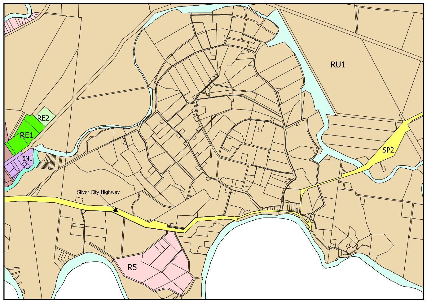

| Page
Page 129 13
Planning Proposal.
Curlwaa
Item 9.10 - Attachment 9 Attachment 9 Post exhibition and consultation amendments to the


| Page
Page 130 14
Planning Proposal.
Ellerslie
Item 9.10 - Attachment 9
Attachment 9 Post exhibition and consultation amendments to the Planning Proposal.


| Page
Page 131 15
Mourquong
Item 9.10 - Attachment 9 Attachment 9 Post exhibition and consultation amendments to


| Page
Page 132 16
the Planning Proposal.
Pomona
Item 9.10 - Attachment 9
Attachment 9 Post exhibition and consultation amendments to the


| Page
Page 133 17
Planning Proposal.
Trentham Cliffs

PLANNING PROPOSAL
AMENDMENT TO THE WENTWORTH LOCAL ENVIRONMENTAL PLAN 2011
RURAL LAND PLANNING CONTROLS
September 2022 Version 3
Item 9.10 - Attachment 10 Attachment 10 Rural Land Planning Controls Planning Proposal (Version 3) for finalisation. Page 134
V1 October 2021 Council Meeting 20/10/21 Michele Bos
V2 April 2022 Public Exhibition & Agency Consultation
V3 September 2022 Council Meeting 28/09/22
Item 9.10
Attachment
Attachment 10 Rural Land Planning Controls Planning Proposal (Version 3) for finalisation. Page 135 PLANNING PROPOSAL – REVIEW OF RURAL LAND PLANNING CONTROLS 2
-
10
Purpose Author Review
Document details Version
Matthew Carlin
Michele
DPE
Bos
Western Region
Michele
DPE
Bos
Western Region
List
Item 9.10 - Attachment 10 Attachment 10 Rural Land Planning Controls Planning Proposal (Version 3) for finalisation. Page 136 PLANNING PROPOSAL – REVIEW OF RURAL LAND PLANNING CONTROLS 3 Table of Contents List of Tables 3 INTRODUCTION 4 PART 1 – OBJECTIVES AND INTENDED OUTCOMES 5 PART 2 – EXPLANATION OF PROVISIONS................................................................................................5 PART 3 – JUSTIFICATION 15 Part 4 – MAPPING 29 Part 5 – COMMUNITY CONSULTATION.................................................................................................29 Part 6 – PROJECT TIMELINE 30 List of Tables Table 1 Proposed RU1 Primary Production zone land use table 5 Table 2 Proposed Part 4 Principal Development Standards..............................................................................6 Table 3 Proposed Part 5 Miscellaneous provisions Clause 5.5 9 Table 4 Schedule 1 Additional permitted uses .................................................................................................9 Table 5 Additional development criteria for new permissible uses 10 Table 6 Proposed RU4 Primary Production Small Lots zone land use table 11 Table 7 Consistency with SEPPs .....................................................................................................................18 Table 8 Consistency with S9.1 Ministerial Directions 23 Table 9 Non-supported uses and justification................................................................................................27 Table 10 Estimated project timeline ..............................................................................................................30
1 Application of RU4 Primary Production Small Lots
2 Application of SP2 Infrastructure (Waste or Resource Management Facilities)
of Figures Figure
Figure
INTRODUCTION
This planning proposal relates to rural land, particularly, that being land affected by the RU1 Primary Production zone and has been prepared to enact the recommendations from the Review of Rural Land Planning Controls paper developed by Wentworth Shire Council. This document is provided in Attachment 1.
The planning proposal seeks to amend the following Wentworth Local Environmental Plan 2011 provisions:
- RU1 Primary Production land use table
- Part 4 Principal development standards relating to rural land
- Part 5 Miscellaneous provisions Clause 5.5
- Schedule 1 Additional permitted uses
- Apply the RU4 Primary Production Small Lots zone to the irrigation districts where the 10 hectares minimum lot size applies
- Apply the SP2 Infrastructure zone to the sites containing existing resource recovery facilities (waste collection and landfill)
The planning proposal has been prepared in accordance with Section 3.33 of the Environmental Planning and Assessment Act 1979 and the Department of Planning and Environment Planning Proposals: A guide to preparing planning proposals August 2016.
The planning proposal seeks a Gateway Determination to proceed under Section 3.34 of the Environmental Planning and Assessment Act 1979.
Wentworth Shire Council is seeking delegation to make this plan as the matters contained in the planning proposal are of local significance. The checklist for the evaluation criteria for the delegation of plan making function will be provided separately.
Item 9.10 - Attachment 10 Attachment 10 Rural Land Planning Controls Planning Proposal (Version 3) for finalisation. Page 137 PLANNING PROPOSAL – REVIEW OF RURAL LAND PLANNING CONTROLS 4
PART 1 – OBJECTIVES AND INTENDED OUTCOMES
This planning proposal proposes to amend the current RU1 Primary Production zone land use table, rural related principal development standards, miscellaneous provisions and additional permitted uses in the Wentworth Local Environmental Plan (WLEP) 2011 as recommended by the RLPC.
The specific objectives and intended outcomes of the planning proposal are to:
a) Allow for rural landholders to diversify and value add to their existing enterprise.
b) Facilitate a range of tourism uses on rural land.
c) Enable a broader range of residential development on rural land.
d) Facilitate boundary adjustments where existing or created allotments do not meet the minimum lot size or create additional allotments.
e) To remove provisions that have expired.
f) Identify and separately map irrigation districts and sites used for waste collection and landfill.
PART 2 – EXPLANATION OF PROVISIONS
The objectives and intended outcomes will be achieved by amending the Wentworth Local Environmental Plan 2011 as follows:
o Replace the current RU1 Primary Production zone land use table as per Table 1 below.
o Amend the rural related Part 4 Principal development standards as per Table 2 below.
o Amend Part 5 Miscellaneous provisions Clause 5.5 as per Table 3 below.
o Amend Schedule 1 Additional permitted uses as per Table 4 below.
o Additional development criteria for new permissible uses in RU1 zone as per Table 5 below.
o Add the RU4 Primary Production Small Lots zone land use table as per Table 6 below.
o Apply the RU4 Primary Production Small Lots zone as shown in Figure 1 below.
o Apply the SP2 Infrastructure zone as shown in Figure 2 below.
Disclaimer: Please be advised that the proposed amendments detailed in the tables below may be subject to change during the legal and Parliamentary Counsel drafting process.
Table 1 Proposed RU1 Primary Production zone land use table
Proposed RU1 Primary Production zone land use table
Zone RU1 Primary Production
1 Objectives of zone
• To encourage sustainable primary industry production by maintaining and enhancing the natural resource base.
• To encourage diversity in primary industry enterprises and systems appropriate for the area.
• To minimise the fragmentation and alienation of resource lands.
• To minimise conflict between land uses within this zone and land uses within adjoining zones.
• To ensure the protection of both mixed dryland and irrigation agricultural land uses that together form the distinctive rural character of Wentworth.
• To ensure land is available for intensive plant agricultural activities.
Item 9.10 - Attachment 10 Attachment 10 Rural Land Planning Controls Planning Proposal (Version 3) for finalisation. Page 138 PLANNING PROPOSAL – REVIEW OF RURAL LAND PLANNING CONTROLS 5
• To encourage and promote the growth and diversification of economic and employment opportunities in agriculture, horticulture and tourism.
• To enable restaurants and cafes and kiosks as part of an agritourism development.
2 Permitted without consent
Agriculture; Environmental protection works; Forestry; Home-based child care; Home business; Home occupations; Roads; Water reticulation system
3 Permitted with consent
Air transport facility; Aquaculture; Artisan food and drink industry; Camping ground; Caravan Parks; Cellar door premise; Dual occupancies (attached); Dwelling house; Eco-tourist facility; Extractive industry; Farm building; Heavy industry; Helipad; Home industry; Intensive livestock agriculture; Kiosk; Landscaping material supplies; Market; Plant nursery; Restaurant or café; Roadside stall; Rural industry; Rural supplies; Rural workers’ dwelling; Secondary dwelling; Self storage units; Sewerage system; Tourist and visitor accommodation; Transport depot; Truck depot; Waste or resource management facility; Any other development not specified in item 2 or 4
4 Prohibited
Amusements centre; Centre-based child care facility; Commercial premises; Correctional centre; Crematorium; Dual occupancies (detached); Early education and care facility; Entertainment facility; Exhibition home; Exhibition village; Function centre; Health services facility; Heliport; Highway service centre; Hospital; Hotel or motel accommodation; Industry; Information and education facility; Light Industry; Liquid Fuel Depot; Marina; Mortuary; Passenger transport facility; Place of public worship; Port facility; Public administration building; Recreation facility (indoor); Residential accommodation; Respite day care centres; Restricted premises; Service station; Serviced apartments; Sex services premise; Storage premises; Vehicle body repair workshop; Warehouse or distribution centres; Wharf or boating facilities; Wholesale supplies
Table 2 Proposed Part 4 Principal Development Standards
Proposed
Part 4 Principal Development Standards
4.1 Minimum subdivision lot size
(1) The objectives of this clause are as follows
(a) to ensure subdivision of land occurs in a manner that promotes suitable land uses and development,
(b) to establish minimum areas for lots that are consistent with the relevant zone objectives,
(c) to prevent the fragmentation of productive rural lands,
(d) to ensure that subdivision does not inappropriately impact on the natural environmental values of the area,
(e) to provide for more intensive, small lot agricultural uses in areas able to access commercial quantities of irrigation water.
(2) This clause applies to a subdivision of any land shown on the Lot Size Map that requires development consent and that is carried out after the commencement of this Plan.
(3) The size of any lot resulting from a subdivision of land to which this clause applies is not to be less than the minimum size shown on the Lot Size Map in relation to that land.
(4) This clause does not apply in relation to the subdivision of any land
(a) by the registration of a strata plan or strata plan of subdivision under the Strata Schemes Development Act 2015, or
Item 9.10 - Attachment 10 Attachment 10 Rural Land Planning Controls Planning Proposal (Version 3) for finalisation. Page 139 PLANNING PROPOSAL – REVIEW OF RURAL LAND PLANNING CONTROLS 6
(b) by any kind of subdivision under the Community Land Development Act 1989
4.1AA Minimum subdivision lot size for community title schemes
(1) The objectives of this clause are as follows
(a) to ensure that land to which this clause applies is not fragmented by subdivisions that would create additional dwelling entitlements.
(2) This clause applies to a subdivision (being a subdivision that requires development consent) under the Community Land Development Act 1989 of land in any of the following zones
(a) Zone RU1 Primary Production,
(b) Zone RU4 Primary Production Small Lots,
(c) Zone C3 Environmental Management,
(d) Zone C4 Environmental Living,
(e) Zone R5 Large Lot Residential, but does not apply to a subdivision by the registration of a strata plan.
(3) The size of any lot resulting from a subdivision of land to which this clause applies (other than any lot comprising association property within the meaning of the Community Land Development Act 1989) is not to be less than the minimum size shown on the Lot Size Map in relation to that land.
(4) This clause applies despite clause 4.1.
4.1B Minimum subdivision lot sizes for certain split zones
(1) The objectives of this clause are as follows
(a) to provide for the subdivision of lots that are within more than one zone and cannot be subdivided under clause 4.1,
(b) to ensure that the subdivision occurs in a manner that promotes suitable land use and development.
(2) This clause applies to each lot (an original lot) that contains (a) land in a village, residential, business or industrial zone, and (b) land in Zone RU1 Primary Production, Zone RU4 Primary Production Small Lots, Zone RU5 Primary Production Small Lots, Zone C2 Environmental Conservation, Zone C3 Environmental Management or Zone C4 Environmental Living.
(3) Despite clause 4.1, development consent must not be granted to subdivide an original lot to create other lots (the resulting lots) unless
(a) one of the resulting lots will contain
(i) land in a residential, business or industrial zone that has an area that is not less than the minimum size shown on the Lot Size Map in relation to that land, and (ii) all of the land in Zone RU1 Primary Production, Zone RU4 Primary Production Small Lots, Zone C2 Environmental Conservation, Zone C3 Environmental Management or C4 Environmental Living that was in the original lot, and
(b) all other resulting lots will contain land that has an area that is not less than the minimum size shown on the Lot Size Map in relation to that land.
4.2A Strata plan subdivision in certain rural zones
(1) The objective of this clause is to ensure that land to which this clause applies is not fragmented by subdivisions that would create additional dwelling entitlements.
(2) This clause applies to land in the following zones that is used, or proposed to be used, for residential accommodation or tourist and visitor accommodation
(a) Zone RU1 Primary Production,
(b) Zone RU4 Primary Production Small Lots,
(c) Zone C3 Environmental Management,
(d) Zone C4 Environmental Living,
Item 9.10 - Attachment 10 Attachment 10 Rural Land Planning Controls Planning Proposal (Version 3) for finalisation. Page 140 PLANNING PROPOSAL – REVIEW OF RURAL LAND PLANNING CONTROLS 7
(e) Zone R5 Large Lot Residential.
(3) Development consent must not be granted for the subdivision of a lot to which this clause applies for a strata plan that would create lots below the minimum size shown on the Lot Size Map for that lot.
4.2B Erection of dwelling houses on land in certain residential, rural and environmental zones
(1) The objectives of this clause are as follows
(a) to minimise unplanned rural residential development,
(b) to enable the replacement of lawfully erected dwelling houses in rural and environmental protection zones.
(2) This clause applies to land in the following zones
(a) Zone RU1 Primary Production,
(b) Zone RU4 Primary Production Small Lots,
(c) Zone C3 Environmental Management,
(d) Zone C4 Environmental Living,
(e) Zone R5 Large Lot Residential.
(3) Development consent must not be granted for the erection of a dwelling house on land in a zone to which this clause applies, and on which no dwelling house has been erected, unless the land is
(a) a lot that is at least the minimum lot size specified for that land by the Lot Size Map, or
(b) a lot created under an environmental planning instrument before this Plan commenced and on which the erection of a dwelling house was permissible immediately before that commencement, or
(c) a lot resulting from a subdivision for which development consent (or equivalent) was granted before this Plan commenced and on which the erection of a dwelling house would have been permissible if the plan of subdivision had been registered before that commencement.
4.2C Rural workers’ dwellings and secondary dwellings
(1) The objectives of this clause are –
(a) to ensure the provision of adequate accommodation for employees of existing agricultural or rural industries, and
(b) to ensure that the erection of rural worker’s dwelling or secondary dwellings does not have an adverse impact on the agricultural or rural industries use of the land.
(2) This clause applies to land in the following zones –
(a) Zone RU1 Primary Production,
(b) Zone RU4 Primary Production Small Lots.
(3) Development consent must not be granted to the erection of a rural worker’s dwelling or a secondary dwelling on land to which this clause applies unless the consent authority is satisfied that the development will not impair the use of the land for agricultural or rural industries.
4.2D Boundary adjustments in Zones RU1, RU4 and E3
(1) The objective of this clause is to facilitate boundary adjustments between lots where one or more of the lots created do not meet the minimum lot size shown on the Lot Size Map in relation to the land but the objectives of the relevant zone can be achieved.
(2) This clause applies to land in the following zones
(a) Zone RU1 Primary Production,
(b) Zone RU4 Primary Production Small Lots,
(c) Zone C3 Environmental Management.
(3) Despite clause 4.1, development consent may be granted to subdivide land to which this clause applies by way of a boundary adjustment between adjoining lots where one or more of the
Item 9.10 - Attachment 10 Attachment 10 Rural Land Planning Controls Planning Proposal (Version 3) for finalisation. Page 141 PLANNING PROPOSAL – REVIEW OF RURAL LAND PLANNING CONTROLS 8
lots created by the subdivision do not meet the minimum lot size shown on the Lot Size Map in relation to that land, if the consent authority is satisfied that
(a) the subdivision will not create additional lots, and
(b) the number of dwelling houses or opportunities for dwelling houses on each lot after the subdivision will remain the same as before the subdivision, and (c) the potential for land use conflict will not be increased as a result of the subdivision, and
(d) if the land is in Zone RU1 Primary Production the subdivision will not have a significant adverse effect on the agricultural viability of the land, and
(e) if the land is in Zone RU4 Primary Production Small Lots- the subdivision will not have a significant adverse effect on the intensive agricultural viability of the land, and
(f) if the land is in Zone C3 Environmental Management the subdivision will result in the continued protection and long-term maintenance of the land, and
(g) the subdivision will not result in any increased bush fire risk to existing buildings.
(4) In determining a development application for the subdivision of land under this clause, the consent authority must consider the following
(a) the existing uses and approved uses of other land in the vicinity of the subdivision,
(b) whether the subdivision is likely to have a significant impact on land uses that are likely to be preferred and the predominant land uses in the vicinity of the development,
(c) whether the subdivision is likely to be incompatible with a land use on any adjoining land,
(d) whether the subdivision is appropriate having regard to the natural and physical constraints affecting the land,
(e) whether the subdivision is likely to have a significant adverse impact on the environmental values of the land.
(5) This clause does not apply
(a) in relation to the subdivision of lots in a strata plan or community title scheme, or (b) if the subdivision would create a lot that could itself be subdivided in accordance with clause 4.1.
Table 3 Proposed Part 5 Miscellaneous provisions Clause 5.5
5.5 Controls relating to secondary dwellings on land in a rural zone
If development for the purposes of a secondary dwelling is permitted under this plan on land in a rural zone –
(a) The total floor area of the dwelling, excluding any area used for parking, must not exceed whichever of the following is the greater –
(i) 110 square metres
(ii) 60% of the total floor area of the principal dwelling.
Table 4 Schedule 1 Additional permitted uses
Schedule 1 Additional permitted uses
1 Use of land marked “Community facilities” in Zone SP1 Special Activities
(1) This clause applies to land within Zone SP1 Special Activities and marked “Community facilities” on the Land Zoning Map
(2) Development for the purposes of dwelling houses or educational establishments is permitted with development consent.
2 Use of certain land at Sturt Highway, Trentham Cliffs
Item 9.10 - Attachment 10 Attachment 10 Rural Land Planning Controls Planning Proposal (Version 3) for finalisation. Page 142 PLANNING PROPOSAL – REVIEW OF RURAL LAND PLANNING CONTROLS 9
(1) This clause applies to the following land at Sturt Highway, Trentham Cliffs
(a) Lot 38 and part of Lot 42, DP 756936, identified as “B” on the Additional Permitted Uses Map, (b) part of Lot 1, DP 1128099, identified as “C” on the Additional Permitted Uses Map.
(2) Development for the purposes of
(a) a highway service centre is permitted with development consent on land referred to in subclause (1)(a), and
(b) a caravan park is permitted with development consent on land referred to in subclause (1)(b).
Table 5 Additional development criteria for new permissible uses
Caravan Parks, Tourist and visitor accommodation
- The site must be provided with adequate all-weather access to service the development
- The development is complementary to the surrounding rural and natural environment
- The development will not have a significant adverse impact on surrounding agricultural production
- The development will not create land use conflict
- The development will not have an adverse impact on the scenic amenity or significant natural features and biodiversity of the area
- Adequate on-site water systems must service the development whilst not having an adverse impact on the water quality in the area
- Adequate water supply must be provided for potable and firefighting purposes
- Demonstrated access to other services required to support the development (power, waste collection etc.)
- The development is not located on flood prone land or within the riverfront area, as defined by the Wentworth LEP 2011, of the Murray and Darling Rivers
Heavy Industry, Hazardous storage establishment and Offensive storage establishment
- The site must be provided with adequate all-weather access to service the development
- The development will not have a significant adverse impact on surrounding agricultural production
- The development will not create land use conflict
- The development will not have an adverse impact on the scenic amenity or significant natural features and biodiversity of the area
- Adequate on-site waster systems must service the development whilst not having an adverse impact on the water quality in the area
- Adequate water supply must be provided for potable and firefighting purposes
- Demonstrated access to other services required to support the development (power, waste collection etc.)
- The development is not located on flood prone land
- A buffer of a minimum of 1000m must be provided between the subject site and any existing dwelling and riverfront area, as defined by the Wentworth LEP 2011, of the Murray and Darling Rivers
Self-storage unit, Transport depot, Truck depot and Vehicle repair station
- The site must be provided with adequate all-weather access to service the development
- The development will not have a significant adverse impact on the surrounding rural and natural environment
Item 9.10 - Attachment 10 Attachment 10 Rural Land Planning Controls Planning Proposal (Version 3) for finalisation. Page 143 PLANNING PROPOSAL – REVIEW OF RURAL LAND PLANNING CONTROLS 10
- The development will not have a significant adverse impact on surrounding agricultural production
- The development will not create land use conflict
- The development will not have an adverse impact on the scenic amenity or significant natural features and biodiversity of the area
- Adequate water supply must be provided for potable (if required) and firefighting purposes
- Demonstrated access to other services required to support the development (power, waste collection etc.)
- The development is not located on flood prone land or within the riverfront area, as defined by the Wentworth LEP 2011, of the Murray and Darling Rivers
Table 6 Proposed RU4 Primary Production Small Lots zone land use table
Proposed RU4 Primary Production Small Lots zone land use table
Zone RU4 Primary Production Small Lots
1 Objectives of zone
• To enable sustainable primary industry and other compatible land uses.
• To encourage and promote diversity and employment opportunities in relation to primary industry enterprises, particularly those that require smaller lots or that are more intensive in nature.
• To minimise conflict between land uses within this zone and land uses within adjoining zones.
2 Permitted without consent
Environmental protection works; Extensive agriculture; Farm buildings; Forestry; Home-based child care; Home businesses; Home occupations; Intensive plant agriculture; Roads; Water reticulation systems
3 Permitted with consent
Agriculture; Air transport facilities; Airstrips; Animal boarding or training establishments; Aquaculture; Bed and breakfast accommodation; Boat launching ramps; Boat sheds; Building identification signs; Business identification signs; Camping grounds; Cellar door premises: Cemeteries; Charter and tourism boating facilities; Community facilities; Correctional centres; Depots; Dual occupancies; Dwelling houses; Eco-tourist facilities; Educational establishments; Environmental facilities; Extractive industries; Farm stay accommodation; Freight transport facilities; Heavy industrial storage establishments; Helipads; Home industries; Home occupations (sex services); Industrial training facilities; Information and education facilities; Intensive livestock agriculture; Jetties; Landscaping material supplies; Local distribution premises; Moorings; Offensive industries; Open cut mining; Plant nurseries; Recreation areas; Recreation facilities (major); Recreation facilities (outdoor); Research stations; Roadside stalls; Rural industries; Rural workers’ dwellings; Sewerage systems; Veterinary hospitals; Water recreation structures; Water supply systems
4 Prohibited
Dual occupancies (detached); Any other development not specified in item 2 or 3
Item 9.10 - Attachment 10 Attachment 10 Rural Land Planning Controls Planning Proposal (Version 3) for finalisation. Page 144 PLANNING PROPOSAL – REVIEW OF RURAL LAND PLANNING CONTROLS 11
Figure 1 Application of RU4 Primary Production Small Lots
Existing Zone
Proposed Zone Buronga Gol Gol


Page 145 PLANNING PROPOSAL – REVIEW OF RURAL LAND PLANNING CONTROLS 12
Item 9.10 - Attachment 10 Attachment 10 Rural Land Planning Controls Planning Proposal (Version 3) for finalisation.
Coomealla
Curlwaa
Ellerslie


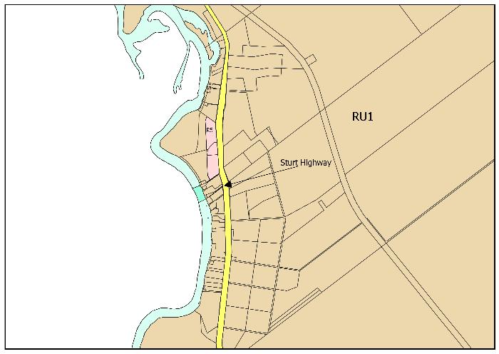


finalisation. Page 146 PLANNING PROPOSAL – REVIEW OF RURAL LAND PLANNING CONTROLS 13
Item 9.10 - Attachment 10 Attachment 10 Rural Land Planning Controls Planning Proposal (Version 3) for
Mourquong
Pomona
Trentham Cliffs
Item 9.10 - Attachment 10 Attachment 10 Rural Land Planning Controls Planning Proposal (Version 3) for finalisation.
Figure 2 Application of SP2 Infrastructure (Waste or Resource Management Facilities)
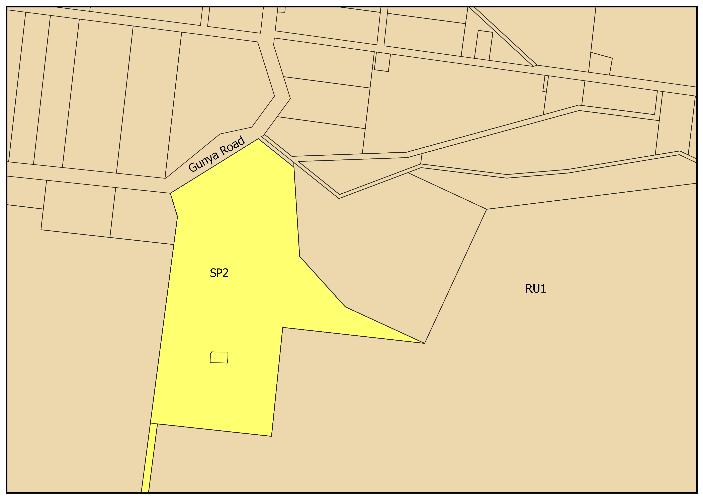


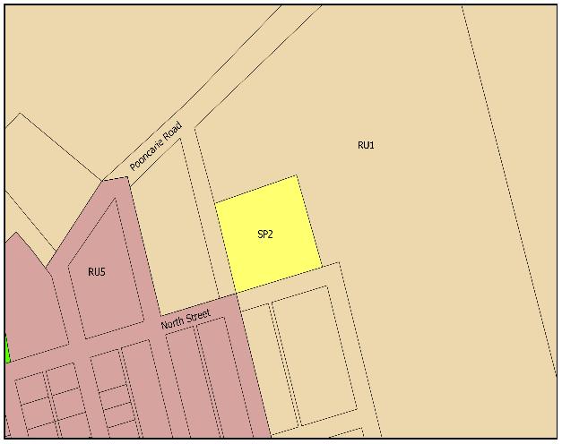

Page 147 PLANNING PROPOSAL – REVIEW OF RURAL LAND PLANNING CONTROLS 14
Dareton
Pooncarie
Wentworth
PART 3 – JUSTIFICATION
This section sets out the reasons for the intended outcomes and provisions in this planning proposal.
Section A – Need for the Planning Proposal
Is the planning proposal a result of any strategic study or report?
Yes. The planning proposal is consistent with the Review of Rural Land Planning Controls paper (RLPC) that was prepared by Wentworth Shire Council in 2021
The RLPC was undertaken to identify current issues relating to the use and development of rural land, to discuss those issues and identify justifiable amendments that would result in the resolution of those issues.
Is the planning proposal the best means of achieving the objectives or intended outcomes, or is there a better way?
This planning proposal is considered to be the best means of achieving the objectives and intended outcomes for the future use and development of rural land in accordance with the Environmental Planning and Assessment Act 1979.
The aim of the planning proposal is to amend the WLEP to provide greater flexibility of permissible uses on RU1 zoned land that are compatible with the current use of land, including tourism, valueadded and diversification development and boundary realignments that will support and facilitate improved management and sustainable financial outcomes for rural enterprises and landholders.
It is believed that the intended outcomes can only be achieved satisfactorily through a planning proposal to amend the current rural land planning controls in the WLEP.
Is there net community benefit?
There is net community benefit from the planning proposal through the generation of economic and social gains in the Wentworth local government area.
The planning proposal will enable existing rural enterprises to expand their current activities to include compatible uses that will increase their financial capacity and sustainability, provide opportunity for growth in localised employment, provide additional activities for the resident community and increased attractions for visitors. All of which will have a flow on effect for existing and future local businesses.
Section B – Relationship to Strategic Planning Framework
Is the planning proposal consistent with the objectives and actions of the applicable regional, subregional or district plan or strategy (including any exhibited draft plans or strategies)?
The planning proposal is consistent with the objectives and directions of the following state and regional planning framework:
Far West Regional Plan 2036
The Far West Regional Plan 2036 sets out the following vision for the wider region:
Item 9.10 - Attachment 10 Attachment 10 Rural Land Planning Controls Planning Proposal (Version 3) for finalisation. Page 148 PLANNING PROPOSAL – REVIEW OF RURAL LAND PLANNING CONTROLS 15
A unique part of Western NSW with a diverse economy supported by the right infrastructure, an exceptional natural environment and resilient communities.
The Plan sets out the following directions and actions relevant to this review document:
▪ Direction 2: Protect productive agricultural land and plan for greater land use compatibility
2.2 Manage the interface between agricultural lands and other land uses to minimise land use incompatibility and fragmentation
▪ Direction 5: Promote tourism opportunities -
5.9 Identify opportunities for tourism uses and associated land uses in local plans
Regional Development Framework (2017): Making it happen in the regions
The Regional Development Framework aims to improve investment coordination and decision making to provide quality services and infrastructure in regional NSW, align efforts to support growing regional centres and identify opportunities to activate local economies.
20 Year Economic Vision for Regional NSW (2021)
The 20-year Vision for Regional NSW sets out the State Governments strategy to drive sustainable, long-term economic growth in regional NSW. It is essentially a roadmap to unlock significant economic potential in regional NSW.
New major investments and economic injections in to projects has provided insight in to the merging sectors of advanced manufacturing, renewable energy and gas and technology enable primary industries. The merging future industries have also been identified as critical minerals, ecotourism, recycling and high-quality food products.
The Western Murray Region includes Wentworth Shire Council where one of the focuses of the document is to develop areas with tourism potential to attract both domestic and international tourists, whilst managing energy and water resources to supply will meet the long term regional needs.
NSW Government Right to Farm Policy (2015)
A Right to Farm Policy was developed by the NSW government in 2015 that aims to protect farmers desire to undertake lawful agricultural practices without conflict or interference from complaints from neighbours and other land users. The policy brings together a suite of actions including:
▪ Reinforcing rights and responsibilities
▪ Establishing a baseline and ongoing monitoring and evaluation of land use conflicts
▪ Strengthening land use planning
▪ Ensure environmental planning instruments, where appropriate, consider rural land use conflict
▪ Consideration of legislative options should additional Government intervention be required.
Item 9.10 - Attachment 10 Attachment 10 Rural Land Planning Controls Planning Proposal (Version 3) for finalisation. Page 149 PLANNING PROPOSAL – REVIEW OF RURAL LAND PLANNING CONTROLS 16
The policy also considers a range of legislative options available to the NSW government if the experience and evidence informed by the implementation of the policy suggest that a legislated response is warranted.
Is the planning proposal consistent with a council’s local strategy or other local strategic plan?
The planning proposal is consistent with the planning priorities and strategic directions of the Wentworth Local Strategic Planning Statement 2020.
The WSC Local Strategic Planning Statement gives effect to:
▪ Priority 2: Protect productive agricultural land and plan for greater land use compatibility
Through six strategic directions:
i. Protect irrigated horticultural land uses in pumped irrigation districts and general irrigation lands outside pumped districts
ii. Manage change in pumped districts of Pomona and Curlwaa by balancing the need to support the productive and sustainable function of existing water infrastructure with pressure for new rural and hobby farm living
iii. Prioritise new irrigated horticulture on suitable land
iv. Support other agricultural land uses including dryland cropping and pastoral farming
v. Facilitate the development of new, innovative and compatible non-agricultural land uses and development, particularly tourism on or near productive agricultural land and by reviewing and amending the rural zone land use table
vi. Prioritise new value-added manufacturing (food processing, packaging and manufacturing) including on site sales (farm gate retail) and related transport facilities on land with safe access to the key regional freight route consisting of the Sturt and Silver City Highways.
▪ Priority 2: Grow Tourism
Through eleven strategic directions:
a. Encourage a range of tourism and visitor accommodation development where it benefits from co-location with a primary productive use or benefits from a rural landscape setting
b. Consider ecotourism facilities as a land use to manage conflicts between horticulture and residential areas in Buronga
c. Encourage a range of tourism development and amenities within settlement boundaries
d. Leverage existing access to the rivers to embellish public along rivers
e. Support tourism developments along the river that do not impact on the health and amenity of the rivers
f. Reinforce Wentworth township’s riverfront precinct
g. Locate cluster moorings and commercial mooring sites close to towns
h. Promote high quality public spaces
i. Improve and maintain access for connectivity to places of heritage significant, adjoining states/towns and popular tourist destinations
j. Deliver new or upgraded infrastructure across the shire
Item 9.10 - Attachment 10 Attachment 10 Rural Land Planning Controls Planning Proposal (Version 3) for finalisation. Page 150 PLANNING PROPOSAL – REVIEW OF RURAL LAND PLANNING CONTROLS 17
k. Consolidate the far west tourism experience by working with the FWJO and associated Councils to prepare a heritage trail.
The planning proposal is also consistent with the Wentworth Shire Council 2022-2032 Community Strategic Plan.
The plan sets out a vision for the region as Wentworth Shire will work together to create a thriving, attractive and welcoming community.
The four strategic goals of the plan are to make Wentworth Shire:
a) A vibrant, growing and thriving region;
b) A great place to live;
c) A community that works to enhance and protect its physical and natural environment; and
d) Supported by strong and ethical civic leadership with all activities conducted in an open, transparent and inclusive manner
The planning proposal gains consistency with the WSC Community Strategic Plan by seeking to ensure greater flexibility in the type of uses permissible on rural land which will support current and emerging trends in agriculture, promote rural enterprise growth and prosperity, creation of localised employment, provide tourism investment opportunities and build on the visitor experience and tourism economy.
Is the planning proposal consistent with applicable State Environmental Planning Policies?
Consistency with applicable State Environmental Planning Policies is outlined below in Table 7
Note: Table 7 addresses the SEPPs applicable at the time of submitting the planning proposal for a Gateway Determination.
Table 7 Consistency with SEPPs
State Environmental Planning Policy (Aboriginal Land) 2019
State Environmental Planning Policy (Activation Precincts) 2020
State Environmental Planning Policy (Affordable Rental Housing) 2009
State Environmental Planning Policy (Building Sustainability Index: BASIX) 2004
State Environmental Planning Policy (Coastal Management) 2018
Item 9.10 - Attachment 10 Attachment 10 Rural Land Planning Controls Planning Proposal (Version 3) for finalisation. Page 151 PLANNING PROPOSAL – REVIEW OF RURAL LAND PLANNING CONTROLS 18
State Environmental Planning Policy (SEPP) Applicable (Y/N) Consistent (Y/N) Comments/Justification
N
N
N
N
N
State Environmental Planning Policy (Concurrences and Consents) 2018
State Environmental Planning Policy (Education Establishments and Child Care Facilities) 2017
State Environmental Planning Policy (Exempt and Complying Development Codes) 2008
The aims of this Policy are as follows:
▪ Providing exempt and complying development codes that have statewide application
▪ Identifying the types of development that are of minimal environmental impact that may be carried out without the need for development consent
▪ Identifying the types of complying development that may be carried out in accordance with a complying development certificate
▪ Enabling the progressive extension of the types of development in this policy
▪ Providing transitional arrangements for the introduction of the state-wide codes including the amendment of other environmental planning instruments
Part 2 of the SEPP exempts certain development from requiring development approval. The types of development exempt from requiring approval relative to rural land, providing certain development standards are met include farm buildings, stock holding yards, grain silos and bunkers and fences.
Part 3A of the SEPP outlines the complying development standards for
Item 9.10 - Attachment 10 Attachment 10 Rural Land Planning Controls Planning Proposal (Version 3) for finalisation. Page 152 PLANNING PROPOSAL – REVIEW OF RURAL LAND PLANNING CONTROLS 19
N
N
Y Y
State Environmental Planning Policy (Gosford City Centre) 2018
State Environmental Planning Policy (Housing for Seniors or People with a Disability) 2004
State Environmental Planning Policy (Infrastructure) 2007
State Environmental Planning Policy (Koala Habitat Protection) 2020
State Environmental Planning Policy (Koala Habitat Protection) 2021
State Environmental Planning Policy (Kosciuszko National Park – Alpine Resorts) 2007
State Environmental Planning Policy (Kurnell Peninsula) 1989
State Environmental Planning Policy (Major Infrastructure Corridors) 2020
State Environmental Planning Policy (Mining, Petroleum Production and Extractive Industries) 2007
State Environmental Planning Policy 19Bushland in Urban Areas
State Environmental Planning Policy 21 –Caravan Parks
rural dwellings on RU1 Primary Production zoned land.
The planning proposal will not alter the application of this SEPP for development that satisfies the development standards of the code.
Y The planning proposal will not reduce or cause impediment to koala habitat.
Y The planning proposal will not reduce or cause impediment to koala habitat.
Item 9.10 - Attachment 10 Attachment 10 Rural Land Planning Controls Planning Proposal (Version 3) for finalisation. Page 153 PLANNING PROPOSAL – REVIEW OF RURAL LAND PLANNING CONTROLS 20
N
N
N
Y
Y
N
N
N
N
N
N
State Environmental Planning Policy 33 –Hazardous and Offensive Development
State Environmental Planning Policy 36 –Manufactured Home Estates
State Environmental Planning Policy 47 –Moore Park Showground
State Environmental Planning Policy 50 –Canal Estate Development
State Environmental Planning Policy 55 –
Remediation of Land
State Environmental Planning Policy 64 –Advertising and Signage
State Environmental Planning Policy 65 –Design Quality of Residential Apartment Development
State Environmental Planning Policy 70 –Affordable Housing (Revised Schemes)
State Environmental Planning Policy (Penrith Lakes Scheme) 1989
State Environmental Planning Policy (Primary Production and Rural Development) 2019
Y
Consideration of potential contamination of land and how it impacts new or future development will need to be considered at the development assessment stage.
Y Where there is new development requiring signage, as a result of greater flexibility in the rural zone, this SEPP will need to be addressed regardless of whether development approval is required or not.
The aims of the Policy relevant to this planning proposal, are as follows:
▪ To facilitate the orderly economic use and development of lands for primary production
▪ To reduce land use conflict and sterilisation of rural land by balancing primary production, residential development and the protection of
Item 9.10 - Attachment 10 Attachment 10 Rural Land Planning Controls Planning Proposal (Version 3) for finalisation. Page 154 PLANNING PROPOSAL – REVIEW OF RURAL LAND PLANNING CONTROLS 21
N
N
N
N
Y
Y
N
N
N
Y Y
State Environmental Planning Policy (State and Regional Development) 2011
State Environmental Planning Policy (State Significant Precincts) 2005
State Environmental Planning Policy (Sydney Drinking Water Catchment) 2011
State Environmental Planning Policy (Sydney Region Growth Centres) 2006
State Environmental Planning Policy (Three Ports) 2013
State Environmental Planning Policy (Urban Renewal) 2010
State Environmental Planning Policy
native vegetation, biodiversity and water resources
▪ To identify state significant agricultural land for the purpose of ensuring the ongoing viability of agriculture on that land, having regard to social, economic and environmental considerations
▪ To simplify the regulatory process for smaller-scale low risk artificial waterbodies, and routine maintenance of artificial water supply or drainage, in irrigation areas and districts, and for routine and emergency work in irrigation areas and districts
▪ To encourage sustainable agriculture, including sustainable aquaculture.
This planning proposal does not change or alter in any way the application of this SEPP on new development in the rural zone.
Item 9.10 - Attachment 10 Attachment 10 Rural Land Planning Controls Planning Proposal (Version 3) for finalisation. Page 155 PLANNING PROPOSAL – REVIEW OF RURAL LAND PLANNING CONTROLS 22
N
N
N
N
N
N
N
(Vegetation in NonRural Areas) 2017
State Environmental Planning Policy (Western Sydney Aerotropolis)2020
State Environmental Planning Policy (Western Sydney Employment Area) 2009
State Environmental Planning Policy (Western Sydney Parklands) 2009
Is the planning proposal consistent with applicable Section 9.1 Ministerial Directions?
Consistency with relevant Section 9.1 Ministerial Directions are detailed below in Table 8
Note: Table 8 addresses the S9.1 Ministerial Directions applicable at the time of submitting the planning proposal for a Gateway Determination.
Table 8 Consistency with S9.1 Ministerial Directions
1. Employment and Resources
1.1 Business and Industrial Zones N
1.2 Rural Zones Y Y
Comments/Justification
1.3 Mining, Petroleum Production and Extractive Industries
1.4 Oyster Aqua Culture
1.5 Rural Lands Y Y
The planning proposal will retain the application of the RU1 Primary Production zone over pastoral and cropping lands where the 10,000 hectares minimum lot size is applied.
The planning proposal will rezone all irrigation districts where the 10 hectares minimum lot size is applied.
While the planning proposal is not triggered by a recommendation contained in a strategic study or plan, it is justified through the Review of Rural Land Planning Controls paper prepared by Wentworth Shire Council.
The review paper highlights the importance of rural land in the Wentworth LGA and the necessity to support rural landholders by
Item 9.10 - Attachment 10 Attachment 10 Rural Land Planning Controls Planning Proposal (Version 3) for finalisation. Page 156 PLANNING PROPOSAL – REVIEW OF RURAL LAND PLANNING CONTROLS 23
N
N
N
Applicable
Consistent
Section 9.1 Direction
(Y/N)
(Y/N)
N
N
2.1 Environment Protection Zones N
2.2 Coastal Protection N
2.3 Heritage Conservation N
2.4 Recreation Vehicle Areas N
2.5 Application of E2 and E3 Zones and Environmental Overlays in Far North Coast LEPs N
providing a level of flexibility in permissible uses to facilitate financial stability and sustainability.
The proposed amendments to the WLEP 2011 will not cause adverse impacts on our valuable natural and historic assets, including our biodiversity, native vegetation, cultural and built heritage and the local natural waterways. Quite the opposite, it will provide rural landholders the opportunity to showcase and share their properties with visitors to the far west NSW region.
The outcomes of the planning proposal will not:
- result in the fragmentation in productive agricultural land
- cause land use conflict between agricultural activities and dwellings on rural land
- adversely affect existing or future rural land uses, but will actually facilitate the development of valueadded activities to build economic capacity and financial sustainability.
The review paper satisfactorily addresses the net community benefit of the social, economic and future interests of the Wentworth community.
In response to the submission made by Department of Primary IndustriesAgriculture, the planning proposal will also rezone all irrigation districts to RU4 Primary Production Small Lots to ensure that any amendments proposed, effecting RU1 Primary Production zone, do not have a detrimental impact on horticultural land.
2. Environment and Heritage
Item 9.10 - Attachment 10 Attachment 10 Rural Land Planning Controls Planning Proposal (Version 3) for finalisation. Page 157 PLANNING PROPOSAL – REVIEW OF RURAL LAND PLANNING CONTROLS 24
2.6 Remediation of Contaminated Land Y Y Agricultural and horticultural activities are included in Table 1 of the Managing Land Contamination Planning Guidelines. The guidelines generally refer to planning proposals that seek to rezone land, of which this planning proposal does not seek to rezone the land. Therefore, under SEPP 55 Remediation of Land, consideration of potential contamination of land and how it impacts new or future development will need to be considered at the development assessment stage.
3. Housing, Infrastructure and Urban Development
3.1 Residential Zones N
3.2 Caravan Parks and Manufactured Home estates N
3.3 Home Occupations (Revoked)
3.4 Integrating Land Use and Transport
3.5 Development Near Regulated Airports and Defence Airfields
3.6 Shooting Ranges N
3.7 Reduction in nonhosted short-term rental accommodation period
4.1 Acid Sulfate Soils
4.2 Mine Subsidence and Unstable Land
4.3 Flooding
4.4 Planning for Bushfire Protection
5.1 Implementation of Regional Strategies (Revoked)
5.2 Sydney Drinking Water Catchments
5.3 Farmland of State and Regional Significance on the NSW Far North Coast
4. Hazard and Risk
5. Regional Planning
Item 9.10 - Attachment 10 Attachment 10 Rural Land Planning Controls Planning Proposal (Version 3) for finalisation. Page 158 PLANNING PROPOSAL – REVIEW OF RURAL LAND PLANNING CONTROLS 25
-
N
N
N
N
N
-
N
N
5.4 Commercial and Retail Development along the Pacific Highway, North Coast (Revoked) -
5.5 Development in the vicinity of Ellalong, Paxton and Millfield (Cessnock LGA) (Revoked) -
5.6 Sydney to Canberra Corridor (Revoked) -
5.7 Central Coast (Revoked) -
5.8 Second Sydney Airport: Badgerys Creek (Revoked) -
5.9 North West Rail Link Corridor Strategy N
5.10 Implementation of Regional Plans Y Y The planning proposal is consistent with the Far West Regional Plan 2036.
5.11 Development of Aboriginal Council land N
6. Local Plan Making
6.1 Approval and Referral Requirements Y Y The planning proposal does not include provisions that require concurrence, consultation or referral to a Minister or public authority.
6.2 Reserving Land for Public Purposes N
6.3 Site Specific Provisions Y Y The planning proposal does not include site specific provisions as it applies to all land within the RU1 Primary Production zone.
7. Metropolitan Planning
Not applicable to Wentworth Shire Council N
Section C – Environmental, social and economic impact
Is there any likelihood that critical habitat or threatened species, populations or ecological communities, or their habitats, will be adversely affected as a result of the proposal?
The proposed amendments to the Wentworth LEP 2011 will not have adverse impacts on critical habitat or threatened species, populations or ecological communities or their habitats.
Are there any other likely environmental effects as a result of the planning proposal and how are they proposed to be managed?
Item 9.10 - Attachment 10 Attachment 10 Rural Land Planning Controls Planning Proposal (Version 3) for finalisation. Page 159 PLANNING PROPOSAL – REVIEW OF RURAL LAND PLANNING CONTROLS 26
There are no other foreseen significant environmental effects associated with the proposed amendments to the Wentworth LEP 2011.
How has the planning proposal adequately addressed any social and economic effects?
The planning proposal will provide opportunities for economic growth and sustainability for rural landholders by allowing additional, compatible uses to be permissible with consent within the RU1 Primary Production zone. There is evidence that an increase in rural enterprise income usually results in an increase in spending at a local level, which has positive flow on effects for the local economy
Social benefits for both rural landholders include growth in visitor numbers to the region, meeting new national and international visitors and growth in employment opportunities in the tourism and business industries.
Section D – State and Commonwealth interests
Is there adequate public infrastructure for the planning proposal?
The planning proposal aims to increase additional use permissibility in the RU1 Primary Production zone. Where new development is proposed, there may be the requirement for improved or new public infrastructure, such as all-weather roads, power and telecommunications facilities.
Where there is a demand for additional public infrastructure or services, the expectation will be that the cost will be borne by the developer, unless, that infrastructure will benefit existing or potentially future landholders. Council’s and developers’ expectations will need to be discussed in detail in the pre-planning stage of each development.
For some types of land uses to be made permissible in the RU1 zone, the planning proposal also specifies new development criteria to be satisfied in order to obtain approval for the development to proceed.
What are the views of State and Commonwealth public authorities consulted in accordance with the gateway determination?
Prior to submitting the Planning Proposal to the Department of Planning requesting a Gateway Determination to proceed, Council consulted with Department of Primary Industries – Agriculture to ensure consistency with their state agricultural land policies.
The original RLPC paper was amended to remove the proposal to amend the current minimum lot sizes as this was not supported by DPI Agriculture.
The proposed additional permissible uses in the RU1 Primary Production, that were not supported by DPI Agriculture, have been listed with additional justification, below:
Table 9 Non-supported uses and justification
Backpackers accommodation
Boat building and repair facility
This use will serve three purposes:
1) provide additional and variety of tourism accommodation facilities for visitors to the region
2) fill a major gap in the provision of accommodation for seasonal workers
3) facilitates an additional income stream for rural landholders.
This type of activity requires space and ease of access to a river and should preferably be located outside of urban environments.
Item 9.10 - Attachment 10 Attachment 10 Rural Land Planning Controls Planning Proposal (Version 3) for finalisation. Page 160 PLANNING PROPOSAL – REVIEW OF RURAL LAND PLANNING CONTROLS 27
Caravan parks
Emergency services facility
Heavy industry
Industrial retail outlet
Industrial zones are not located within close proximity to rivers and therefore, this use should be permissible in the RU1 zone.
To take advantage of the natural outback environment and provide a variety of rurally located accommodation facilities, similar to other far west local councils such as Balranald, Central Darling, Bourke and Carrathool.
This type of development is permitted under the SEPP (Transport and Infrastructure) 2021.
This type of development requires separation from other more sensitive developments, particularly away from townships. While normally it would be located in a heavy industrial zone, where that land would have previously been RU1 zone, Wentworth LGA does not have sufficient enquiry or demand to warrant rezoning tracks of rural land to facilitate the establishment of this type of use. However, by permitting this use in the RU1 zone, Council facilitates the establishment of this type of development in locations where there would be adequate separation from sensitive uses and space.
This use is generally used in conjunction with rural industry (and industry which will remain prohibited) and permits the sale of goods that have been manufactured on the land on which the rural industry is located.
Kiosk
Light industry
Restaurant/Café
Transport depot
Truck depot
This use facilitates the provision of refreshments or convenience items where there are other uses or activities occurring on the site. For example, uses such as camping ground, eco-tourist accommodation and the proposed farm experience premises uses in the Agritourism amendment would benefit from including the provision of quick/light food and drinks to those who are utilising those services. A kiosk is a small-scale activity as per Section 5.4(6) of the WLEP.
This use includes artisan food and drink industry (new use supported by DPI Agriculture), home industry (currently permissible), high technology industry (currently prohibited) and creative industry (currently prohibited). It is considered that there is no compelling reason not to include home industry and artisan food as it is supported by DPI Agriculture, and continue to permit home industry as permissible with consent in the RU1 zone.
There is a growing trend in the rural sector of processing and manufacturing raw produce for retail sale on site. This activity can be successfully operated in conjunction with an associated restaurant or cafe, similar to cellar door sales with associated food provision services. These types of rural enterprises are becoming increasingly popular with tourists and the local community. This type of development would form part of an agritourism development.
May require larger areas of land to operate this type of use and would be more suitable outside of town boundaries. Considered compatible with rural land uses.
May require larger areas of land to operate this type of use and would be more suitable outside of town boundaries. The type of
Item 9.10 - Attachment 10 Attachment 10 Rural Land Planning Controls Planning Proposal (Version 3) for finalisation. Page 161 PLANNING PROPOSAL – REVIEW OF RURAL LAND PLANNING CONTROLS 28
machinery stored and serviced also includes farm machinery. Considered compatible with rural land uses.
Vehicle repair station This type of use includes the permissibility to repair all machinery including agricultural machinery and is considered compatible with rural land uses. It would also facilitate an additional income stream for rural land holders
In accordance with the Gateway Determination, Council provided a copy of the exhibition documents to DPI Agriculture and provided 28 days for a response. The response received 6 June 2022 requested a meeting to discuss their ongoing concerns, particularly related to some of the additional permitted uses in the proposed land use table for RU1 zone and the removal of Clause 4.2D.
Following the meeting held 26 July 2022, a final response to the planning proposal was received from DPI Agriculture 5 August 2022.
In response to the final submission received, additional amendments have been made to the planning proposal to satisfy the concerns and objection made by DPI Agriculture. These included:
- applying the RU4 Primary Production Small Lots zone over existing irrigation districts where the 10 hectares minimum lot size applies, with a land use table identical to the current RU1 Primary Production zone and
- adding development criteria for uses that were not fully supported.
Further details on this matter and the resultant amendments made to the planning proposal are provided in the Section 3.36 Planning Report.
Part 4 – MAPPING
The planning proposal seeks to amend parts of the following Land Zoning maps of the Wentworth Local Environmental Plan 2011:
▪ Sheet LZN_002 (Map Identification Number: 8200_COM_LZN_002_320_20170421)
▪ Sheet LZN_002D (Map Identification Number: 8200_COM_LZN_002D_020_20220321)
▪ Sheet LZN_002E (Map Identification Number: 8200_COM_LZN_002E_020_20200409)
▪ Sheet LZN_002F (Map Identification Number: 8200_COM_LZN_002F_020_20200220)
▪ Sheet LZN_002H (Map Identification Number: 8200_COM_LZN_002H_020_20170421)
▪ Sheet LZN_002I (Map Identification Number: 8200_COM_LZN_002I_020_20170421)
▪ Sheet LZN_002K (Map Identification Number: 8200_COM_LZN_002K_020_20170421)
▪ Sheet LZN_003A (Map Identification Number: 8200_COM_LZN_003A_020_20110809)
▪ Sheet LZN_004 (Map Identification Number: 8200_COM_LZN_004_320_20190918)
▪ Sheet LZN_004A (Map Identification Number: 8200_COM_LZN_004A_020_20170118)
▪ Sheet LZN_004C (Map Identification Number: 8200_COM_LZN_004C_020_20110805)
▪ Sheet LZN_004E (Map Identification Number: 8200_COM_LZN_004E_020_20110805)
▪ Sheet LZN_004F (Map Identification Number: 8200_COM_LZN_004F_020_20111130)
▪ Sheet LZN_004G (Map Identification Number: 8200_COM_LZN_004G_020_20210217)
▪ Sheet LZN_004H (Map Identification Number: 8200_COM_LZN_004H_020_20190918)
A request will be made to the Department of Planning and Environment GIS mapping team, to prepare the LEP maps on Council’s behalf.
Item 9.10 - Attachment 10 Attachment 10 Rural Land Planning Controls Planning Proposal (Version 3) for finalisation. Page 162 PLANNING PROPOSAL – REVIEW OF RURAL LAND PLANNING CONTROLS 29
Part 5 – COMMUNITY CONSULTATION
Public exhibition and community consultation will be undertaken by Council as part of the Gateway determination process.
It is proposed that the planning proposal is exhibited for a period of 28 to 42 days in accordance with Clause 4 of Schedule 1 of the Environmental Planning & Assessment Act 1979 and the NSW Department of Planning and Environment’s: A guide to preparing local environmental plans 2016
A public hearing will not be conducted as part of the public exhibition process.
Update: Community consultation was conducted from 6 May 2022 to 10 June 2022. Two public submissions were received. Details of the submissions and Council’s response are provided in the Section 3.36 Planning Report.
Part 6 – PROJECT TIMELINE
The indicative timeframe for completing the planning proposal is outlined in Table 10 below:
Table 10 Estimated project timeline
Task
Timeframe
Anticipated commencement date (date of Gateway determination) March 2021
Completion of required technical information N/A
Public exhibition/Community consultation May – June 2022
State agency consultation May – June 2022
Public hearing (if required) N/A
Consideration of submissions May 2022
Consideration of planning proposal post exhibition (Council report) September 2022
Request Opinion from Parliamentary Counsel September 2022
Submission to the Department to finalise the LEP November 2022
Date RPA will make the plan (if delegated) October 2022
Date RPA will forward to the Department for notification November 2022
Item 9.10 - Attachment 10 Attachment 10 Rural Land Planning Controls Planning Proposal (Version 3) for finalisation. Page 163 PLANNING PROPOSAL – REVIEW OF RURAL LAND PLANNING CONTROLS 30
9.11 NSW DEPARTMENT OF PLANNING AND ENVIRONMENT - AGRITOURISM REFORMS
File Number: RPT/22/593
Responsible Officer: Matthew Carlin - Director Health and Planning Responsible Division: Health and Planning Reporting Officer: Michele Bos - Strategic Development Officer
Objective: 1.0 Wentworth Shire is a vibrant, growing and thriving Region Strategy: 1.1 Promote the Shire as an ideal location for investment and the establishment of innovative, sustainable and diversified industries
Summary
A report was tabled at Council’s Ordinary Meeting, held 16 February 2022, advising of the Department of Planning & Environment’s intent to draft an amendment to the Standard Instrument (Local Environmental Plans) Order 2006 to facilitate agritourism.
The report required Council to nominate the rural zones where agritourism will be permissible. Council resolved to include Agritourism as permissible with consent in the RU1 Primary Production and C4 Environmental Living zones.
As a result of an amendment to the Rural Land Planning Controls Planning Proposal, which makes a recommendation for the addition of the RU4 Primary Production Small Lots zone to the Wentworth Local Environmental Plan 2011, Council should determine if agritourism uses are to be permissible within that new zone and advise the Minister for Planning and Homes accordingly.
Recommendation
That Council:
1. Resolve to advise the Minister for Planning and Homes that the RU4 Primary Production Small Lots zone is to include Agritourism as permissible with consent.
2. That a division be called in accordance with S375A of the Local Government Act 1993 (NSW).
Detailed Report
Purpose
The purpose of this report is to provide Council with the opportunity to nominate the proposed new RU4 Primary Production Small Lots zone as suitable for agritourism uses.
Background
To support the resilience and sustainability of regional communities and farming enterprises, the NSW Government has made a commitment to growing emerging industries by facilitating the establishment of supplementary industries related to agriculture. One of those industries is agritourism.
Agritourism is a tourism related product or experience that connects agriculture and its products with people and places, by allowing visitors on a farm or in a rural environment to enjoy the space, be educated and/or participate in activities and events. Agritourism activities will also enable primary producers to diversify their on-farm incomes whilst maintaining primary production on the land as the principle use.
The reforms will include an amendment to the Standard Instrument and individual Local Environmental Plans, where Councils have nominated zones to list agritourism as
Ordinary Meeting AGENDA 28 September 2022 Page 164
permissible with consent. Wentworth Shire Council resolved to nominate the RU1 Primary Production and C4 Environmental Living zones to permit agritourism with consent, at its meeting in February 2022.
Councils have been provided the opportunity to nominate zones, in addition to those already nominated, by 14 October 2022.
Matters under consideration
A separate report in this agenda, the Rural Land Planning Controls Planning Proposal, seeks Council endorsement of an amendment to the planning proposal to include the RU4 Primary Production Small Lots zone. The application of the RU4 zone would encompass horticultural land where the minimum lot size of 10 hectares is applied.
With the addition of the RU4 zone, Council needs to consider if it is appropriate to include that zone in the agritourism reforms.
It is considered that agritourism should be permissible with consent in the RU4 zone. This is justified as the previous resolution of Council included horticultural areas, as they are currently affected by the RU1 zone.
Options
Based on the information contained in this report, the options available to address this matter are to:
- Advise DPE that Agritourism is to be included in the RU4 Primary Production Small Lots zone land use table
Legal, strategic, financial or policy implications
The recommendation made in this report is consistent with Council’s strategic planning directions for rural land in the Wentworth local government area. There are no legal, financial or policy implications.
Conclusion
The recommendation made to Council ensures consistency with facilitating tourism and value-added industries on rural land.
Attachments
Nil
Ordinary Meeting AGENDA 28 September 2022 Page 165
9.12 REVIEW OF DETERMINATION DA2021/051
File Number: RPT/22/494
Responsible Officer: Matthew Carlin - Director Health and Planning
Responsible Division: Health and Planning
Reporting Officer: Matthew Carlin - Director Health and Planning
Objective: 4.0 Wentworth Shire is supported by strong and ethical civic leadership with all activities conducted in an open, transparent and inclusive manner
Strategy: 4.2 A strong, responsible and representative government
Summary
Council has received an application from James Golsworthy Consulting on behalf of their client for a review of determination for DA2021/051. This DA was approved by Council as a three (3) lot boundary realignment – see Attachment 1.
This request for Review of Determination is specifically seeking to remove condition No. 9 of the Notice of Determination which prohibits the erection of dwellings on Lots 1 and 2 – see Attachment 2.
This Review of Determination is being presented to Council for assessment and a decision under section 8.3 of the Environmental Planning and Assessment Act 1979.
Recommendation
That Council resolve to confirm the original Notice of Determination issued for DA2021/051 and retain condition 9 prohibiting dwellings on Lots 1 and 2.
That a division be called in accordance with S375A of the Local Government Act 1993
Detailed Report
Purpose
The purpose of this report is to inform Council of the matters raised relating to DA2021/051 to enable a decision to be made pursuant to the obligations of Wentworth Shire as a Consent Authority under the Act and Local Environmental Plan (LEP) for the purposes of this Review.
Background
At the Ordinary meeting of Council on 21 July 2021, DA2021/051 for a three (3) lot boundary realignment was presented to Council with a planning recommendation for Council to refuse development approval.
The recommendation to refuse was based on the following planning justification:
a) The gazetted minimum lot size (MLS) for the subject sites are 10 hectares
b) The plan of subdivision showed the proposed river front titles were below the MLS
c) The purpose for the subdivision was not for the sole purpose of ‘primary production’
The provisions of the LEP that apply to this DA are:
a) Clause 4.3 - Land in a zone to which this clause applies may, with development consent, be subdivided for the purpose of primary production to create a lot of a size that is less than the minimum size shown on the Lot Size Map in relation to that land.
b) Clause 4.2(4) - Such a lot cannot be created if an existing dwelling would, as the result of the subdivision, be situated on the lot.
Ordinary Meeting AGENDA 28 September 2022 Page 166
The confirmed Minutes from that meeting show that Council overturned the planning recommendation and resolved to approve DA2021/051, thus allowing the creation of lots in the RU1 Primary Production zone below the minimum lot size – see Attachment 3.
Existing Use Rights vs Dwelling Entitlements
The definition of existing use rights can be found in clause 4.65 of the Environmental Planning and Assessment Act 1979. It is the use of a building, work or land (previous development) that was lawfully commenced under a previous planning instrument but is now prohibited by another planning instrument.
An existing use is presumed to have expired or been ‘abandoned’ if an existing building ceases to be used for a continuous period of 12 months. Information provided by James Golsworthy Consulting states the dwelling on Lot 3 was demolished after August 2019. Existing use rights do not apply to buildings which have been demolished per section 4.66 of the EP&A Act.
Existing use rights are separate to dwelling entitlements. A dwelling entitlement refers to a Councils ability to approve a dwelling on a lot subject to any constraints or prohibitions set down in a planning instrument.
Conversely Wentworth Local Environmental Plan 2011 clause 4.2B Erection of dwelling houses on land in Zones RU1 and E3 – has two objectives
1. The objectives of this clause are as follows:
a) To minimise unplanned rural residential development
b) To enable the replacement of lawfully erected dwelling houses in rural and environmental protection zones
Proposed Lot 1 having an area of 1.30 hectares is land to which a dwelling was demolished with council consent (DA2019/064).
Proposed Lot 2 having an area of 2.82 hectares has a dwelling house and ancillary buildings thereon.
Proposed Lot 3 having an area of 35.06 hectares is the balance of the land set aside for horticultural land.
The subject land is in Zone RU1 Primary Production with a minimum lot size of 10 hectares. Proposed Lot 3 effectively subject to Council approval be subdivided into three allotments, each with a dwelling house. This is not the intent of the applicant. Rather the subdivision allows the development of Primary Production land separately from the houses on the Southern Side of the highway.
James Golsworthy Consultancy identifies clearly through history that all parcels of land have had dwelling houses erected upon all allotments. The settlement pattern has dwelling houses adjacent to the river and the horticulture land on the northern side of the highway. While the request is for a review of the subdivision conditions the impact may be the ability to replace the dwelling that was demolished with Council consent (DA2019/064).
Review of Determination
James Golsworthy Consulting has written to Council seeking a review of determination to remove condition no. 9 of the Notice of Determination on behalf of their client.
Condition 9 states:
‘No dwellings will be approved/allowed for proposed Lots 1 and 2.
Reason: To comply with the Wentworth Local Environmental Plan 2011.’
In their correspondence, James Golsworthy Consulting states, ‘condition 9 of the Notice of Determination and the LEP does not include any prohibition for dwellings on Lot 1 or 2’
Ordinary Meeting AGENDA 28 September 2022 Page 167
Regardless of the outcome of this review, dwellings on these lots are prohibited by the LEP. Therefore, any application made for such via the ePlanning Portal will be returned to the applicant as Council cannot accept DAs for prohibited development pursuant to section 4.3 of the EP&A Act which states:
‘If and environmental planning instrument provides that –
a) Specified development is prohibited on land to which the provision applies, or
b) Development cannot be carried out on land with or without development consent, a person must not carry out the development on the land’.
Options
Based on the information contained in this report, the options available to address this matter are to:
a) Confirm the Notice of Determination issued for DA2021/051 and retain condition 9 prohibiting dwellings on Lots 1 and 2, or;
b) Accept the request for the review of determination and remove condition 9 of DA2021/51
Legal, strategic, financial or policy implications
Where the applicant is not satisfied with the outcome of a review of determination, they have the right to apply to the Land and Environment Court to appeal the decision.
Attachments
1. Application for Review of Determination (Under Separate Cover)
2. Request for Review of Determination⇩
3. Minutes Ordinary Meeting of Council 21 July 2021⇩
Ordinary Meeting AGENDA 28 September 2022 Page 168
 MrKenRoss GeneralManager
WentworthShireCouncil POBox81
Wentworth NSW 2648
22July 2022
DearKen
TRENTHAMCLIFFS
DEVELOPMENTCONSENTDA2021/051
SECTION8.3REVIEWOFDETERMINATION
Withoutprejudice
Weacton behalfofSpareWeel Pty Ltd(‘Spare Weel’). Spare Weelaretheproponentof DA2021/051 being a development application for a 3 lot subdivision by way of boundary realignment at Lot 3 DP733472, Lot 2 DP829971andLot54DP756936mbeingattheSturtHighwayTrenthamCliffs.
Atitsmeetingof21July2021Councilresolvedtoapprovetheapplication. TheCouncilminutesforthemeeting areattached. Thisisdespitetheofficerrecommendationbeingforrefusaloftheapplicationandnoconditions beingincludedintheofficersassessmentreport. Ofnoteiscondition9oftheconsentwhichisprovidedbelow.
9. No dwellings will be approved/allowed for proposed Lots 1 and 2. Reason: To comply with the Wentworth Local Environmental Plan 2011.

We hereby lodge an application to review the condition 9 of the consent as provided at section 8.3 of the EnvironmentalPlanningandAssessmentAct.
In support of the application for review we offer the following justification for Council to review the condition andforittoberemoved.
The consent provided the reason for the condition was to comply with the LEP however the LEP does not include any prohibition for dwellings on either of lots 1 or 2. The land is included in zone RU1 Primary production and dwelling houses are permitted with consent. Dwellings existed on the land as demonstrated by the stamped plan accompanying the application and the land where the dwellings were sited included horticulturaloperations intheformofirrigatedhorticulturetopermanentplantings.

Lots 1 and 2 at the time of the application being considered by Council benefit from existing use rights for a dwellingoradwellingexistingontheland. Lot2DP829971containstwodwellingsandassociatedoutbuildings
OurRef:22-070
Item 9.12 - Attachment 2 Request for Review of Determination Page 169

along with the horticultural activities. The dwellings have existing on the land since prior to 1979. Lot 3 DP733472 previously contained a dwelling as is evidenced by a review of the site and aerial imagery. The dwellinghasexistedonthelandpriorto1979asdemonstratedin Figure5. Thedwellingwasdemolishedafter August2019.


Item 9.12 - Attachment 2 Request for Review of Determination Page 170
OurRef:22-070 2
Figure1 Lot 2 DP829971 and the existing dwellings located of the land (Nearmap 6 July 2022)


Item 9.12 - Attachment 2 Request for Review of Determination Page 171 Our
22-070 3
Ref:
Figure2 . Lot 3 DP733472 and the existing dwelling (Nearmap 30 August 2019)

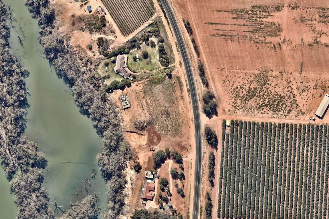
Division 4.11 of the Environmental Planning and Assessment Act 1979 (EP&AAct) provides the opportunity for an existing use to be established in particular circumstances. Section 4.65 of the Act provides that an existingusemeans:
(a) the use of a building, work or land for a lawful purpose immediately before the coming into force of an environmental planning instrument which would, but for this Division, have the effect of prohibiting that use, and
(b) the use of a building, work or land—
(i) for which development consent was granted before the commencement of a provision of an environmental planning instrument having the effect of prohibiting the use, and
(ii) that has been carried out, within one year after the date on which that provision commenced, in accordance with the terms of the consent and to such an extent as to ensure (apart from that provision) that the development consent would not lapse.
Wesubmitthatthe12-monthperiodof abandonmentintheEP&AActsought tostrikeabalancebetweenthe rights of landowners whose uses of land become adversely affected by planning changes, and the public expectationthatplanningchangesareimplemented.
InresponsetoCovid-19on19March2020theMinisterforPlanningandPublic Spacesmadechangestothe provisionsoftheEP&AActwhichrelatetoexistinguserights.Suchrightshavebeengranteda2year"lifeline" during the prescribed period of 25 March 2020 to 25 March 2022 through amendments to sections 4.66 and 4.68oftheEP&AAct.Thismeansthatanexistinguserightduringthisperiodwillnowexpireonlyafter3years ofcontinuousabandonment(previously12months).Thechangewillpreserveexistinguserightsforbuildings
OurRef:22-070 4
Item 9.12 - Attachment 2 Request for Review of Determination Page 172
Figure3 Lot 3 DP733472 and the existing dwelling (Nearmap 11 November 2019)
ordevelopmentswhichmayhavegoneintoaCOVID-19stateof"hibernation"becausetenantscan'tbefound, orforothercommercialreasons.
Wesubmitthatdwellingsoneachofthelotsbenefitfromexistinguserightsonthebasisofthefollowing:
Thedwellingsdonotappeartohaveexistedonthelandin1945(Figure 4)
Thedwellingshaveexistedonthelandsincebefore1979
Evidence of the dwellings being located on the land is available through a review of aerial imagery particularly Google Earth and Nearmap. Google Earth demonstrates the dwellings being located on the landasat theirearliestavailableforthelocationimagebeingAugust2005
Historical aerial photography demonstrates the dwellings being located on the land at this time and prior to1979
Therefore, dwellings existed on the land or had a right to exist on the land at the time of the application for subdivision (DA2021/051) being considered by Council. The condition is therefore not applicable to the land asitseekstocontrolalegitimateandlegaluseasprovidedbytheEP&AAct.
ForreasonsdetailedaboveCondition9oftheconsent isthereforeinconsistentwiththeEP&AActandshould bedeletedfromtheconsent.
Shouldyourequireanyfurtherinformation, pleasecontactourofficeon:0350228411.
Yourssincerely,
JamesGolsworthyConsulting JamesGolsworthy Director
Item 9.12 - Attachment 2 Request for Review of Determination Page 173 OurRef:22-070 5

Item 9.12 - Attachment 2 Request for Review of Determination Page 174 OurRef:22-070 6 Figure4 Aerial imagery of the land and location of the dwellings 1945 www.imagery.aerialphotography.fsdf.org.au


Item 9.12 - Attachment 2 Request for Review of Determination Page 175 OurRef:22-070 7
Figure5 Aerial image of the land and dwellings 1979 www.imagery.aerialphotography.fsdf.org.au
ORDINARY
9.13 DA2021/051 BOUNDARY RE-ALIGNMENT 6753 STURT HIGHWAY GOL GOL
File Number: RPT/21/411
Responsible Officer: Matthew Carlin - Director Health and Planning
Responsible Division: Health and Planning
Reporting Officer: Matthew Carlin - Director Health and Planning
Objective: 1.0 Wentworth is a vibrant, growing and thriving Shire Strategy: 1.2 Encourage and support population growth and resident attraction
Summary
A Development Application DA2021/051 was received by Council for a boundary realignment to create two (2) river frontage titles and one horticultural property title on RU1 – Primary Production zoned land being Lot 2 DP 829971, Lot 3 DP 733472 and Lot 54 DP 756936.
This development application is being presented to Council for a resolution as it does not meet statutory provisions of the Wentworth LEP 2011.
Recommendation
That Council having considered the content of this report, resolve to refuse development approval for DA2021/051.
That a division is called in accordance with s375A of the Local Government Act 1993 (NSW).
Amendment
That Council having considered the content of this report, resolve to approve development approval for DA2021/051.
That a division is called in accordance with s375A of the Local Government Act 1993 (NSW).
Council Resolution
That Council having considered the content of this report, resolve to approve development approval for DA2021/051.
That a division is called in accordance with s375A of the Local Government Act 1993 (NSW).
Moved Cr. Elstone Seconded Cr. Wheeldon
CARRIED
In accordance with Section 375A of the Local Government Act the Mayor called for a division.
For the Motion : Clr.s Elstone, Heywood, McKinnon, Nichols and Wheeldon. Against the Motion: Clr.s Evans, MacAllister and Nunan.
Item 9.12 - Attachment 3 Minutes Ordinary Meeting of Council 21 July 2021 Page 176
Page
MEETING MINUTES 21 JULY 2021
21
9.13 DA2021/050 STAGES 1 TO 6 (161 LOT SUBDIVISION) OF A 262 LOT SUBDIVISION LOT 2 & 3 DP 878007 AND LOT 2 DP 1014681 BURONGA
File Number: RPT/22/603
Responsible Officer: Matthew Carlin - Director Health and Planning Responsible Division: Health and Planning Reporting Officer: George Kenende - Development Assessment Officer
Objective: 1.0 Wentworth Shire is a vibrant, growing and thriving Region Strategy: 1.1 Promote the Shire as an ideal location for investment and the establishment of innovative, sustainable and diversified industries
Summary
A development application (DA2021/050) was received by Council for a subdivision to be located at Lot 2 & 3 DP 878007 and Lot 2 DP 1014681 Buronga.
Under clause 2.6 of the Wentworth Local Environmental Plan 2011 (WLEP 2011), subdivisions are permitted with consent. The proposed subdivision proposes to create Lots with areas ranging from 612 sqm to 4790 sqm.
The application was publicly notified three (3) times for 14 days as per Council Community Participation Plan. During the 3 notifications:
• Notification 1: 3 Submissions were received during the notification period
• Notification 2: 7 Submissions were received during the notification period
• Notification 3: 2 Submissions were received after the notification period
As no submissions were withdrawn by the submitters and some of the submissions over the 3 notification periods were by the same submitter, for the purpose of this development application, assessment was conducted under the assumption that eight (8) unique submissions were received.
As per Council delegations, any development applications with 3 or more submissions cannot be determined under delegated authority, and must be determined by Council.
Recommendation
1. That Council approve DA2021/050 being Stages 1 to 6 (161 Lot Subdivision) of a 262 Lot Subdivision located at Lot 2 & 3 DP 878007 and Lot 2 DP 1014681 Buronga
2. Call a division in accordance with S375A of the Local Government Act 1993 (NSW)
Detailed Report
Purpose
The purpose of this report is to provide information for Council to determine Development Application DA2021/050, having consideration to the detail provided both within this report and the attachments provided.
Background
A Development Application was lodged with Council on 9 April 2021 seeking consent to subdivide the land into 121 Lots. During the assessment process, amendments were made to the overall subdivision plan, with the final plan of subdivision being for Stages 1 to 6 (161 Lot Subdivision) of a 262 Lot Subdivision.
Ordinary Meeting AGENDA 28 September 2022 Page 177
The subject lot is located in the RU5 Village zone, which does not have a minimum Lot size. DA2021/050 was publicly notified 3 times due to the subdivision plan amendments as per Council Community Participation Plan for 14 days, with a total of 8 unique submissions received during this time.
As per Council delegations, any development applications with 3 or more submission cannot be determined under delegated authority, and must be determined by Council.
Refer to attachment 1 – Development Application (Under separate cover)
Refer to attachment 2 – Subdivision Plan
Refer to attachment 3 – Statement of Environmental Effects
Refer to attachment 4 – Traffic Impact Assessment Report
Matters under consideration
In determining a development application that requires consent, the consent authority must take into consideration matters prescribed in Section 4.15 of the Environmental Planning and Assessment Act 1979 as relevant to the development.
The proposed development was assessed against and met the relevant principles and provisions under the State Environmental Planning Policy (Biodiversity and Conservation) 2021 and State Environmental Planning Policy (Transport and Infrastructure) 2021.
The proposed development for subdivision is permitted with consent and meets the zone objectives of the RU5 Village zone under the WLEP 2011. Land zoned RU5 does not have a minimum lot size under the WLEP 2011.
Due to the nature of the proposed development, it was assessed against Chapter 3 of the Wentworth Development Control Plan (DCP) 2011. The proposed development met relevant provisions of the Wentworth Development Control Plan (DCP) 2011.
The proposed application met planning priority 6 of the Wentworth Local Strategic Planning Statement which aims to:
• “Provide a range of housing options, including affordable housing, housing for older people, family housing and temporary worker accommodation based on an analysis of local demographics and future demand” and
• “Manage land use conflict through the use of setbacks and buffer zones in subdivision layouts, mitigate potential impacts in building location and design and generally avoid affecting the economic viability of land needed to support key factors of the local economy”
The subject land is located within the Buronga township, and was assessed against the Buronga/Gol Gol Structure Plan 2020 (BGGSP) which is a DPE endorsed strategic plan. The BGGSP aims to “Promote a mixture of urban development that allows for flexibility to respond to changes in the community over time and cater for a diversity of land sizes and housing types”. The proposed subdivision has residential Lots over 600 sqm, complying with the proposed minimal Lot size of 600sqm for high residential areas. The subject land is also located in proximity of services (shops, community centre, bus stop).
As the subject land is adjoined by rural zoned lands to the north and east, land use conflict and buffer zones were considered in the assessment. The proposed Lots are anticipated to be used for residential, which is considered a sensitive use. As such, the document named “Buffer zones to reduce land use conflict with agriculture: An interim guideline” by DPI: Agriculture was used as a guide to determine appropriate mitigation measures to the land use conflict. These mitigation measures were identified in the draft condition of consents.
During public notifications 8 unique submissions were received. The main concerns raised by the submitters and Council officer response are as follows:
Ordinary Meeting AGENDA 28 September 2022 Page 178
• Traffic
The impacts of the traffic increase along Pitman Avenue and Melaleuca Street was addressed in the Traffic Impact Assessment (TIA) provided with the development application. The TIA identified the anticipated traffic increase and the required road upgrades needed to ensure safe traffic movement.
• Road safety
These matters were adequately addressed in the TIA, and the appropriate recommendation in the TIA were included in the approval as required.
• Traffic into Pitman Avenue
These matters were adequately addressed in the TIA, and the appropriate recommendation in the TIA were included in the approval as required.
• Pedestrian safety
These matters were adequately addressed in the TIA, and pedestrian pathways will be made available throughout the subdivision. Their design and exit points will be designed in line with Council future pedestrian movement plan for the area.
• On-road parking safety concern in Pitman venue
These matters were adequately addressed in the TIA, and the appropriate recommendation in the TIA were included in the approval as required. This included widening of Pitman avenue to allow better traffic movement and safer on-street parking in Pitman.
• Easement along the west boundary of Lot 2 DP 1014681 and access to it
This development is only for stage 1 to 6. Stage 8, which is made up of Lot 2 DP 1014681 will require a separate development application. Matters regarding the removal of easements from the land will be addressed at this stage.
• Water rights
As part of the subdivision, Council policy AF011 identifies the need for water for the new allotments. This was addressed in the condition of consent.
• Privacy
The proposed development is for subdivision only. Any future development on the new allotments will be assessed on their own merits, including matters relating to privacy.
• Construction Noise (during subdivision and future developments)
Condition of consent have in place measures to control noise generation during subdivision works. This will be same for all new developments on the new allotments.
• Vibration impacts to property
Condition of consent put in place to control vibration impacts on adjoining lands during subdivision works.
• Access to site
These matters were adequately addressed in the TIA, and the appropriate recommendation in the TIA included in the conditions of consent as required in terms of the 2 main accessways into the development site from Pitman and Melaleuca.
• Tree protection
The trees along Pitman will have to be removed to allow the widening of the road and accessways from the new allotments. New tree plantings, in line with Council street tree planting policy (C008), will be required along Pitman.
• Major Infrastructure along Pitman
Ordinary Meeting AGENDA 28 September 2022 Page 179
During assessment it was identified that there was a major telecommunication infrastructure beneath Pitman Avenue. The infrastructure Is within the Pitman road reserve and measures were included in the conditions of consent to ensure the subdivision works do not impact it.
• Recreation Land in subdivision
The final proposed subdivision plan identifies a number of recreation areas proposed for the development (Lots 24, 34 and 161).
• Timespan of Construction of housing on the new blocks
The pace of development for the land depends on a number of factors that will be determined by the beneficiary of the development.
• Traffic Noise
The traffic movement anticipated for the area will mostly be domestic traffic. The noise will be in line with the traffic noise in the area and along the highway.
The application was referred to the following external agencies:
- Transport for NSW: No objection to the development and provided comments
- Essential Energy: No objection to the development and provided comments
- Western Murray Irrigation: No objection subject to condition
Based on the assessment of the application and concerns raised by the submitters, it is determined that the proposed development is consistent with the relevant matters under the:
• Wentworth Local Environmental Plan 2011
• Wentworth Development Control Plan 2011
• State Environmental Policies
• Wentworth Local Strategic Planning Statement
• Buronga Gol Gol Structure Plan
• Relevant Council Policies
Refer to attachment 5 – 4.15 Assessment Report
Refer to attachment 6 – Submissions 1 (Under separate cover)
Refer to attachment 7 – Submissions 2 (Under separate cover)
Refer to attachment 8 – Submissions 3 (Under separate cover)
Refer to attachment 9 – Response to submission by applicant (Under separate cover)
Refer to attachment 10 – Conditions of consent
Refer to attachment 11 – Agency responses (Under separate cover)
Options
Based on the information contained in this report, the options available to address this matter are to:
Approve Development Application 2021/050 subject to conditions
Legal, strategic, financial or policy implications
Should Council issue a determination to the application, the applicant has the right to submit a request for review of the determination to Council under Section 8.2 of the Environmental Planning & Assessment Act 1987
The applicant also has the right to appeal the decision made by Council to the Land and Environment Court pursuant to Section 8.7 of the Environmental Planning & Assessment Act 1987.
Ordinary Meeting AGENDA 28 September 2022 Page 180
Conclusion
Having consideration to the content of this report it is concluded that the appropriate course of action is to approve DA2021/050 subject to conditions within the report
Attachments
1. Development Application (Under separate cover)
2. Subdivision Plan⇩
3. Statement of Environmental Effects⇩
4. Traffic Impact Assessment Report⇩
5. 4.15 Assessment Report⇩
6. Submission 1 (Under separate cover)
7. Submission 2 (Under separate cover)
8. Submission 3 (Under separate cover)
9. Further information Response (Under separate cover)
10. Draft conditions of consent⇩
11. External Agency Reposnses (Under separate cover)
Ordinary Meeting AGENDA 28 September 2022 Page 181
Item 9.13 - Attachment 2 Subdivision Plan Page 182 171665m² 172666m² 173666m² 759m²175 700m²176 182975m²840m²184840m²840m²186840m²185840m²187191895m²190840m²189840m²188 1931495m² 196699m² 197731m² 800m²199923m²198 200880m² 201880m² 880m²202 880m²203 204880m² 210880m² 880m²211 212880m² 213880m² 214880m² 215880m² 880m²216 2191449m² 223928m² 224919m² 225957m² 994m²226 1031m²227 228819m² 229819m² 230819m² 819m²231 232819m² 233945m² 234945m² 899m²235880m²236237880m²875m² 238 239825m² 240762m² 700m²241 242700m² 252808m² 253915m² 254928m² 258730m² 813m²259 601m²262 221841m² 2720m²744m² 3 31624m² 32624m² 33625m² 28744m²720m² 29 56598m² 57597m² 58596m² 59663m² 60821m² 63738m² 847m² 23840m²22800m²21840m²20800m²19842m² 18 68730m² 69672m² 70780m² 705m²73679m²74 679m²7576679m² 728m²8081728m² 27 2091109m² 716m²77 775m²78728m²79 13893m² 30612m² 16779m² 17848m² 15839m² 14838m² 13838m² 12838m² 11838m² 10838m² 9837m² 8838m² 7838m² 6838m² 5838m² 4838m²838m² 26838m² 25879m² 54931m² 55777m² 928m²83726m²82 1058m²205 1121m²207 2081386m² 735m²72 3792m² 2792m² 1797m² 222968m² 804m²251 2471007m²2441267m²245903m²246840m² 2431013m² 261600m² 600m²260 255800m² 2501296m²1051m² 249 2481064m² 1250m²159 126782m² 158967m² 979m²151 157853m² 1561006m² 1521029m² 1531014m² 1551000m²1031m²154 1280m²160 125946m² 122800m² 800m²123 124805m² 121806m² 65705m²64773m² 66676m²752m²67 87842m²86828m² 834m²84 826m²85 88955m² 120944m² 119852m² 1179m²89 901018m² 943m²91 737m²117816m²116115735m²114735m² 146932m² 813m²111 733m²112835m²113 96800m² 806m²136138766m²137766m²766m²766m²140766m²139141142766m²766m²145956m²144766m²143 755m²135754m²134131755m²132755m²133755m²755m²128755m²129755m²130755m²127 92800m² 800m²93 94800m² 800m²95 118800m² 920m²150147908m²148920m²149920m² 174722m² 53825m² 62734m²61821m² 71748m² 2171219m² 2181484m² 2201425m² 981m²206 934m²183 1921299m² 194943m² 842m²195 1771102m² 178897m² 180894m²1791125m² 1008m²181 97816m² 905m²256 257825m² PITMAN AVENUE ROAD PROPOSED ROADPROPOSED PROPOSED COURT MELALEUCA STREET STREETROSE STREETPOOLEY DRIVECRANE 1DP1002306 2DP1002306 100DP756946 95DP756946 94DP756946 DP825883 6DP264142 1DP1014681 1DP840576 2DP840576 453DP1217477 PLAN OF PROPOSED SUBDIVISION LOTS 2 & 3 IN DP 878007, LOT 2 IN DP 1014681 & PART LOT 453 IN DP1217477 (BEING REDUNDANT SUPPLY & DRAINAGE RESERVE) AT BURONGA PROPOSED ROAD PROPOSED COURT PROPOSED COURTROADPROPOSED ROAD PROPOSED ROAD PROPOSED ROAD PROPOSED ROAD PROPOSED ROAD PROPOSED COURT PITMAN AVENUE STAGE 8 STAGE 1 COURTPROPOSED 40853m²838m²3938839m² 815m² 42830m² 41 51847m²52850m² 900m²109108900m² 46835m²835m²45835m²44815m² 43 35835m²830m²36829m² 37 107900m²900m² 106901m²105 103815m²843m²104 804m²110 98951m²99831m² 49847m²50847m²48847m²47853m² 100815m²101815m²102815m² PROPOSED ROAD STAGE 2 STAGE 3 STAGE 4 STAGE 5 STAGE 6 STAGES 1 TO 7 STAGE 8 PROPOSED 825m² 1613472m² 24 4790m²34 STAGE 1
PRELIMINARY

Item 9.13 - Attachment 3 Statement of Environmental Effects Page 183

Item 9.13 - Attachment 3 Statement of Environmental Effects Page 184

Item 9.13 - Attachment 3 Statement of Environmental Effects Page 185

Item 9.13 - Attachment 3 Statement of Environmental Effects Page 186

Item 9.13 - Attachment 3 Statement of Environmental Effects Page 187

Jacaranda Rise (NSW) Pty Ltd
Item 9.13 - Attachment 4 Traffic Impact Assessment Report Page 188 61 Pitman Avenue, Buronga, NSW Residential Subdivision Traffic Impact Assessment Report Client:
Project No. 210042 FINAL2 Report – 12/07/2022 1st Floor 132 Upper Heidelberg Road Ivanhoe Vic 3079 PO Box 417 Ivanhoe Vic 3079 Ph: (03) 9490 5900 www.trafficworks.com.au

DOCUMENT CONTROL RECORD
Document prepared by:
Trafficworks Pty Ltd
ABN 59 125 488 977
1st Floor 132 Upper Heidelberg Rd Ivanhoe Vic 3079
PO Box 417 Ivanhoe Vic 3079
Ph (03) 9490 5900 www.trafficworks.com.au
DISCLAIMER
The information contained in this document is intended to be received, used, and relied upon by the named addressee or client only for the purpose for which it has been prepared Trafficworks Pty Ltd does not warrant the accuracy or relevance of the information, including by implication, contained in this document if it is used or relied upon by any person other than the named addressee or client. Copying, reproduction including by electronic means, unauthorised use or disclosure of this document is prohibited except with the express written authorisation of Trafficworks Pty Ltd.
Document Control
Report Title

61 Pitman Avenue, Buronga, NSW – Residential Subdivision Traffic Impact Assessment Report
Project Number 210443
Client Jacaranda Rise (NSW) Pty Ltd
Client Contact Jason Earle (of Earle Civil Pty Ltd)
Draft 17/12/21 Issued for review
Final 20/01/22 Issued to client
DRAFT2 01/07/22 Respond to TfNSW RFI
FINAL2 12/07/22 Sent to client
Stuart Redman / Dilenthi Dissanayake
Stuart Redman / Dilenthi Dissanayake
Kate Kennedy
Kate Kennedy
Bernadette Sargeant / Stuart Redman Ali Abdou
Bernadette Sargeant / Stuart Redman Ali Abdou
210443: 61 Pitman Avenue, Buronga, NSW – Residential Subdivision – Traffic Impact Assessment Report
FINAL2: 12/07/2022
Item 9.13 - Attachment 4 Traffic Impact Assessment Report Page 189
ii
Rev Date Issued Revision Details / Status Prepared by Authorised by
EXECUTIVE SUMMARY
Trafficworks has been engaged by Earle Civil Pty Ltd, on behalf of Jacaranda Rise (NSW) Pty Ltd, to undertake a Traffic Impact Assessment for the proposed residential subdivision at 61 Pitman Avenue in Buronga, NSW
This report will accompany a Development Application (DA No. 2021/050) to Wentworth Shire Council (the Council).
A Traffic Impact Assessment was conducted to:
• estimate traffic generation and distribution associated with the proposed development
• determine the suitability of the proposed access locations onto the adjacent road network
• determine the likely traffic impacts on the existing road network
• identify any necessary mitigating works.
A summary of the subject site and the proposed development is shown below.
Address 61 Pitman Avenue, Buronga, NSW
Zoning Village Zone (RU5)
Proposed development
Road network
Traffic generation
The proposed residential development consists of the following:
• 262 residential dwelling lots
• an internal trafficable road network
• Pitman Avenue
• Melaleuca Avenue
• 1,939 daily vehicle trips
• 186 weekday morning peak hour vehicle trips
• 204 weekday evening peak hour vehicle trips
Recommendations
• Recommendation 1: minimum SISD requirements of 123 m and 214 m at the proposed access locations onto Pitman Avenue and Melaleuca Street, respectively, should be checked during the detailed design of the development.
• Recommendation 2: any landscaping within the verge near the access locations onto Pitman Avenue and Melaleuca Street should be positioned so that it will not obscure or obstruct drivers’ line of sight.
• Recommendation 3: implement speed zoning and traffic calming devices for the internal roads exceeding 250 m per AGTM8 Traffic management devices are required for straight sections of road length of 250 m.
• Recommendation 4: no trees or fencing should be installed at any proposed intersections that could restrict sight lines.
210443: 61 Pitman Avenue, Buronga, NSW – Residential Subdivision – Traffic Impact Assessment Report FINAL2: 12/07/2022
Item 9.13 - Attachment 4 Traffic Impact Assessment Report Page 190
iii
• Recommendation 5: all roads should be designed to provide enough space for an 8.8 m emergency/service vehicle to travel through the network safely.
• Recommendation 6: a temporary court bowl cul-de-sac treatment should be implemented at the termination of all roads for each stage.
• Recommendation 7: the final development plans must indicate footpaths within the subdivision.
• Recommendation 8: Pitman Avenue and Melaleuca Street are widened and constructed for the subject site frontage to include kerb and channel to the satisfaction of the Council.
Referenced documents
References used in the preparation of this report include the following:
• RTA Guide to Traffic Generating Developments, Version 2.2, October 2002
• Technical Direction – Guide to Traffic Generating Developments Updated traffic surveys (TDT 2013/04a)
• Austroads Guide to Road Design
o Part 4: Intersections and Crossings - General
o Part 4A: Unsignalised and Signalised Intersections
• Wentworth River Shire Council:
o Local Environmental Plan 2011
o Development Control Plan 2011
210443: 61 Pitman Avenue, Buronga, NSW – Residential Subdivision – Traffic Impact Assessment Report FINAL2: 12/07/2022
Item 9.13 - Attachment 4 Traffic Impact Assessment Report Page 191
iv
Item 9.13 - Attachment 4 Traffic Impact Assessment Report Page 192 210443: 61 Pitman Avenue, Buronga, NSW – Residential Subdivision – Traffic Impact Assessment Report FINAL2: 12/07/2022 v TABLE OF CONTENTS 1 INTRODUCTION 1 2 EXISTING CONDITIONS ..................................................................................................................2 2.1 Subject site 2 2.2 Road network .........................................................................................................................4 2.3 Traffic volumes 9 2.4 Crash history 11 2.5 Public transport 11 2.6 Pedestrian and cyclist accessibility 11 3 PROPOSED DEVELOPMENT 12 3.1 Proposed development summary 12 4 TRAFFIC GENERATION AND DISTRIBUTION 14 4.1 Traffic generation 14 4.2 Traffic distribution onto the surrounding road network.................................................... 15 4.3 Anticipated traffic volumes 15 5 ASSESSMENT.............................................................................................................................. 17 5.1 Sight distance 17 5.2 Turn provisions.................................................................................................................... 18 5.3 Intersection analysis 24 6 DEVELOPMENT INTERNAL ROAD LAYOUT 30 6.1 Speed zoning and traffic calming 30 6.2 Intersection design 30 6.3 Emergency and service vehicle access 30 6.4 Termination of internal roads 31 6.1 Pedestrian access............................................................................................................... 31 6.2 Proposed development road 31 6.3 Frontage roads.................................................................................................................... 31 7 RESPONSE TO TfNSW 32 7.1 Pre-application response.................................................................................................... 32 7.2 Post submission of TIAR response 32 8 CONCLUSIONS AND RECOMMENDATIONS................................................................................ 34 APPENDIX A – PROPOSED DEVELOPMENT PLANS APPENDIX B – SIDRA OUTPUTS
1 INTRODUCTION
Trafficworks has been engaged by Earle Civil Pty Ltd, on behalf of Jacaranda Rise (NSW) Pty Ltd, to undertake a Traffic Impact Assessment for the proposed residential subdivision at 61 Pitman Avenue in Buronga, NSW.
This report will accompany a Development Application (DA No. 2021/050) to Wentworth Shire Council (the Council).
A Traffic Impact Assessment was conducted to:
• estimate traffic generation and distribution associated with the proposed development
• determine the suitability of the proposed access locations onto the adjacent road network
• determine the likely traffic impacts on the existing road network
• identify any necessary mitigating works.
210443: 61 Pitman Avenue, Buronga, NSW – Residential Subdivision – Traffic Impact Assessment Report FINAL2: 12/07/2022
Item 9.13 - Attachment 4 Traffic Impact Assessment Report Page 193
1
2 EXISTING CONDITIONS
2.1 Subject site
The subject site is 61 Pitman Avenue, north of Buronga in NSW, approximately 7 km northeast of the Mildura town centre in Victoria The subject site is currently used as farmland. Refer to Figure 1 for the location of the subject site and the surrounding road network. The land zoning is shown in Figure 2.


210443: 61 Pitman Avenue, Buronga, NSW – Residential Subdivision – Traffic Impact Assessment Report FINAL2: 12/07/2022
Item 9.13 - Attachment 4 Traffic Impact Assessment Report Page 194
2
Figure 1: Aerial Photograph (Source: Nearmap)
SUBJECT SITE
Figure 2: Land Use and Locality Plan (Source: ePlanning Spatial Viewer – Planning Portal – NSW Government Website)

SUBJECT SITE

The subject site falls within the Village Zone (RU5) under the Wentworth Shire Council (the Council) Local Environment Plan (LEP); refer to Figure 2.
210443: 61 Pitman Avenue, Buronga, NSW – Residential Subdivision – Traffic Impact Assessment Report
FINAL2: 12/07/2022
Item 9.13 - Attachment 4 Traffic Impact Assessment Report Page 195
3
2.2 Road network
2.2.1 Pitman Avenue
Pitman Avenue is a local road managed by Council, aligned generally in an east to west direction, and provides a connection between Gol Gol North Road to the east and Silver City Highway to the west Pitman Avenue is a two-way, two-lane undivided carriageway, with traffic lanes of approximately 3.1 metres and unsealed shoulders on the northern side and kerb and channel on the southern side Refer to Photos 1 - 4
A posted speed limit of 50 km/h applies along Pitman Avenue in the vicinity of the subject site.


210443: 61 Pitman Avenue, Buronga, NSW – Residential Subdivision – Traffic Impact Assessment Report FINAL2: 12/07/2022
Item 9.13 - Attachment 4 Traffic Impact Assessment Report Page 196
4
Photo 1: Pitman Avenue, on the approach to Melaleuca Street intersection, looking west
Photo 2: Pitman Avenue, on the approach to Melaleuca Street intersection, looking east


210443: 61 Pitman Avenue, Buronga, NSW – Residential Subdivision – Traffic Impact Assessment Report
FINAL2: 12/07/2022
Item 9.13 - Attachment 4 Traffic Impact Assessment Report Page 197
5
Photo 3: Pitman Avenue adjacent to the proposed access location, looking east
Photo 4: Pitman Avenue adjacent to the proposed access location, looking west
2.2.2 Melaleuca Street
Melaleuca Street is a local road managed by Council. It is aligned north-south and connects with Corbett Avenue / Alcheringa Drive to the north and Sturt Highway to the south Melaleuca Street is a two-way road with a sealed carriageway of approximately 5.4 m. Melaleuca Street has unsealed shoulders within the road section north of the Pitman Avenue intersection. It has a kerb and channel on the eastern side of the road, south of the Pitman Avenue intersection. Refer to Photos 5 and 6.
A posted speed limit of 80 km/h applies along Melaleuca Street, in the vicinity of the proposed site access location. The speed limit changes to 50 km/h, approximately 140 m north of the Pitman Avenue intersection.


210443: 61 Pitman Avenue, Buronga, NSW – Residential Subdivision – Traffic Impact Assessment Report FINAL2: 12/07/2022
Item 9.13 - Attachment 4 Traffic Impact Assessment Report Page 198
6
Photo 5: Melaleuca Street looking south
Photo 6: Melaleuca Street looking north
2.2.3 Sturt Highway (A20)
The Sturt Highway is an arterial road managed by Transport for New South Wales (TfNSW). It is generally aligned in an east to west direction and provides a connection between the Hume Highway to the east in Tarcutta and Adelaide to the west.
South of the subject site, the Sturt Highway (known locally as Hendy Road) is a two-way, two-lane road with sealed shoulders There is no provision for bicycles and pedestrians along the road. Right turn treatments are provided at the intersections with Melaleuca Street and Rose Street.
A posted speed limit of 60 km/h applies along the Sturt Highway, south of the subject site.


210443: 61 Pitman Avenue, Buronga, NSW – Residential Subdivision – Traffic Impact Assessment Report FINAL2: 12/07/2022
Item 9.13 - Attachment 4 Traffic Impact Assessment Report Page 199
7
Photo 7: The Sturt Highway at the intersection with Melaleuca Street, looking east
Photo 8: The Sturt Highway at the intersection with Melaleuca Street, looking west
2.2.4 Silver City Highway (B79)
The Silver City Highway is an arterial road managed by TfNSW. It is generally aligned in a north to southeast direction. It connects Barrier Highway to the north in Broken Hill and Sturt Highway in Buronga to the southeast.
The Silver City Highway is a two-way, two-lane road with sealed shoulders. There is no provision for bicycles and pedestrians along the road. On the approach to Buronga, the highway becomes a twoway, four-lane carriageway with sealed shoulders.
A posted speed limit of 60 km/h applies along the Silver City Highway on the north approach to Buronga A roundabout controls the intersection of the Silver City Highway and the Sturt Highway.


210443: 61 Pitman Avenue, Buronga, NSW – Residential Subdivision – Traffic Impact Assessment Report FINAL2: 12/07/2022
Item 9.13 - Attachment 4 Traffic Impact Assessment Report Page 200
8
Photo 9: Silver City Highway on the approach to Pitman Avenue Street intersection looking south
Photo 10: Silver City Highway on the approach to Pitman Avenue Street intersection looking north
2.3 Traffic volumes
Traffic surveys were undertaken to determine the existing traffic volumes on Wednesday, 1 June 2022, at the following intersections:
• Pitman Avenue / Melaleuca Street
• Pitman Avenue / Silvery City Highway
• Melaleuca Street / Sturt Highway
• Rose Street / Sturt Highway
• Silver City Highway / Sturt Highway
The typical peak hour for the intersections surveyed was identified as 8:00 – 9:00 am (AM peak hour) and 4:30 – 5:30 pm (PM peak hour).
The peak hour traffic volumes are shown in Figure 3
210443: 61 Pitman Avenue, Buronga, NSW – Residential Subdivision – Traffic Impact Assessment Report
FINAL2: 12/07/2022
Item 9.13 - Attachment 4 Traffic Impact Assessment Report Page 201
9

Item 9.13 - Attachment 4 Traffic Impact Assessment Report Page 202 210443: 61 Pitman Avenue, Buronga , NSW –Residential Subdivision –Traffic Impact Assessment Report FINAL2 : 12/07/2022 10 Figure 3: Existing traffic volumes –Wednesday 1 June 2022
2.4 Crash history
The TfNSW Centre for Road Safety website was accessed; notably, the Crash and Casualty Statistics database stores details of all injury crashes on roads throughout NSW. Scrutiny of these records indicates that two crashes have occurred near the subject site in the last five-year period that data is available for (01/01/2016 – 31/12/20).
The details of the crashes are summarised below:
• one ‘Off-road to left into an object’ crash resulting in a towaway (non-casualty) occurred along Pitman Avenue, south of the subject site, in 2019 during daylight conditions
• one ‘Cross traffic’ crash resulting in a towaway (non-casualty) occurred at the intersection of Pitman Avenue and Melaleuca Street, southeast of the subject site, in 2018 during daylight conditions.
Although there were two crashes within the surrounding road network, analysis of the crash types from the TfNSW: Definitions and notes to support road crash data determined that no crash trends have been established. Hence it can be concluded that the roads near the subject site do not have a traffic safety problem that requires urgent remedial action.
Conclusion 1: no trends in crashes were observed within the vicinity of the subject site in the last five-year period. Hence there are no traffic safety problems that require urgent remedial action.
2.5 Public transport
Bus service Mildura to Euston to Robinvale operates south of the subject site along the Sturt Highway. The nearest bus stop is adjacent to the Rose Street / Sturt Highway intersection, approximately 320 m south of the subject site.
2.6 Pedestrian and cyclist accessibility
No pedestrian and cyclist facilities are located along Pitman Avenue and Melaleuca Street in the vicinity of the subject site.
210443: 61 Pitman Avenue, Buronga, NSW – Residential Subdivision – Traffic Impact Assessment Report FINAL2: 12/07/2022
Item 9.13 - Attachment 4 Traffic Impact Assessment Report Page 203
11
3 PROPOSED DEVELOPMENT
3.1 Proposed development summary
The proposed development comprises 262 residential dwelling lots with an internal trafficable road network. The following staging is proposed:
• Stage 1 - 3 lots
• Stage 2 - 23 lots
• Stage 3 - 33 lots
• Stage 4 - 31 lots
• Stage 5 - 34 lots
• Stage 6 - 29 lots
• Stage 7 - 17 lots
• Stage 8 - 92 lots.
Vehicular access to the subject site is proposed to be provided via an internal road onto Pitman Avenue to the south and an internal road onto Melaleuca Street east of the subject site There are lots fronting Pitman Avenue and Melaleuca Street, which will have direct access to the fronting roads.
It is noted that a single lot of approximately 4,000 m2 is located to the west of the proposed internal road onto Pitman Avenue. The future development of this land would be subject to a separate Development Application
The concept development plan is shown in Figure 4 and Appendix A.
210443: 61 Pitman Avenue, Buronga, NSW – Residential Subdivision – Traffic Impact Assessment Report FINAL2: 12/07/2022
Item 9.13 - Attachment 4 Traffic Impact Assessment Report Page 204
12

Item 9.13 - Attachment 4 Traffic Impact Assessment Report Page 205 210443: 61 Pitman Avenue, Buronga , NSW –Residential Subdivision –Traffic Impact Assessment Report FINAL2 : 12/07/2022 13
the proposed development plan
Figure
4 : Extract of
4 TRAFFIC GENERATION AND DISTRIBUTION
4.1 Traffic generation
The reference document commonly used to estimate likely traffic volumes from development is the RTA Guide to Traffic Generating Developments Version 2.2A, October 2002 (the RTA Guide). The Department of Transport Roads and Maritime Services (formerly the RTA) has published a Technical Direction for the document (TDT 2013/04a) titled ‘Guide to Traffic Generating Developments Updated traffic surveys (the updated RTA Guide).
4.1.1 Residential dwellings
The updated RTA Guide measured the following traffic generation rates for low-density residential dwellings in regional areas:
• 7.4 daily vehicle trips per dwelling
• 0.71 weekday morning peak hour vehicle trips per dwelling
• 0.78 weekday evening peak hour vehicle trips per dwelling
Based on the rates above, the proposed 262residential lots are expected to generate:
• 1,939 daily vehicle trips
• 186 weekday morning peak hour vehicle trips
• 204 weekday evening peak hour vehicle trips
Table 1 shows each stage's summary traffic generation from the proposed development
Table 1: Daily and peak traffic volumes - at full development
From Table 4, at full development, the proposed development is likely to generate a total daily traffic volume of 1,939 vpd with a morning peak of 186 vph and an evening peak of 204 vph.
210443: 61 Pitman Avenue, Buronga, NSW – Residential Subdivision – Traffic Impact Assessment Report FINAL2: 12/07/2022
Item 9.13 - Attachment 4 Traffic Impact Assessment Report Page 206
14
Stage No. of lots RTA Traffic Generation Rate Trip Generation (No. of vehicles) Daily Vehicle Trips AM peak Vehicle Trips PM peak Vehicle Trips Daily AM Peak PM Peak Stage 1 3 7.4 0.71 0.78 22 2 2 Stage 2 23 170 16 18 Stage 3 33 244 23 26 Stage 4 31 229 22 24 Stage 5 34 252 24 27 Stage 6 29 215 21 23 Stage 7 17 126 12 13 Stage 8 92 681 65 72 Total 262 1,939 186 204
Conclusion 2: the proposed development at completion is likely to generate a total daily traffic volume of 1,939 vpd with a morning peak of 186 vph and an evening peak of 204 vph.
4.2 Traffic distribution onto the surrounding road network
Peak hour traffic flow for the proposed development would generally be distributed as follows:
• AM Peak Hour
• PM Peak Hour
20% entering / 80% leaving
70% entering / 30% leaving
As per the access arrangements, of the 262 residential lots:
• 203 lots are likely to use the internal road connection to Pitman Avenue
• 18 lots will have direct access onto Pitman Avenue (lots 4 and 6 – 19)
• 28 lots are likely to use the internal road connection to Melaleuca Street
• 13 lots will have direct access onto Melaleuca Street.
For this assessment, it has been assumed lot 20 will have access to Melaleuca Street due to the proximity to the intersection with Pitman Avenue
The following directional splits are assumed at the two site access points based on the road network.
• traffic movements would predominantly travel to/from the: Pitman Avenue
o west (90%) along Pitman Avenue
o east (10%) along Pitman Avenue
Melaleuca Street
o south (90%) along Pitman Avenue
o north (10%) along Pitman Avenue
The wider road network has also been assessed based on the existing splits at the intersection.
4.3 Anticipated traffic volumes
It is anticipated that the residential subdivision will likely be staged during development, with construction commencing in 2023 Assuming a stage is constructed each year, the residential subdivision will be completed by 2030.
The anticipated traffic volumes at ten years post-development (i.e. the year 2040) are summarised in Figure 5
210443: 61 Pitman Avenue, Buronga, NSW – Residential Subdivision – Traffic Impact Assessment Report FINAL2: 12/07/2022
Item 9.13 - Attachment 4 Traffic Impact Assessment Report Page 207
15
Item 9.13 - Attachment 4 Traffic Impact Assessment Report Page 208 210443: 61 Pitman Avenue, Buronga , NSW –Residential Subdivision –Traffic Impact Assessment Report FINAL2 : 12/07/2022 16 Figure 5 : Anticipated traffic volumes –10 years postdevelopment
5 ASSESSMENT
5.1 Sight distance
The visibility criterion typically applied to intersections is Safe Intersection Sight Distance (SISD). This is nominated in the Austroads Guide to Road Design, Part 4A (AGRD4) as the minimum distance which should be provided on the major road at any intersection (refer to Section 3.2.2 in AGRD4A). This gives sufficient distance to a driver of a vehicle on the major road to observe a vehicle from the minor access approach moving into a collision situation (e.g. in the worst case, stalling across the traffic lanes) and to decelerate to a stop before reaching the collision point (refer Figure 6 below).

The minimum SISD criterion specified in Table 3.2 of the Austroads Guide requires clear visibility for a desirable minimum distance of 123 m and 214 m relating to the general reaction time RT of 2.0 seconds and a design speed1 of 60 km/h along Pitman Avenue and 90 km/h along Melaleuca
1 Design speed = operational speed + 10 km/h for rural roads
210443: 61 Pitman Avenue, Buronga, NSW – Residential Subdivision – Traffic Impact Assessment Report
FINAL2: 12/07/2022
Item 9.13 - Attachment 4 Traffic Impact Assessment Report Page 209
17
Figure 6: Safe Intersection Sight Distance (SISD) (Source: Figure 3.2 from Austroads Guide to Road Design Part 4A)
Street, respectively. This sight distance applies to Pitman Avenue and Melaleuca Street at the proposed development access points.
Generally, Pitman Avenue and Melaleuca Street have flat alignments along the subject site frontage. Any landscaping within the verge near the access intersections should be positioned so that it will not obscure or obstruct drivers’ line of sight.
Recommendation 1: minimum SISD requirements of 123 m and 214 m at the proposed access locations onto Pitman Avenue and Melaleuca Street, respectively, should be checked during the detailed design of the development.
Recommendation 2: any landscaping within the verge near the access locations onto Pitman Avenue and Melaleuca Street should be positioned so that it will not obscure or obstruct drivers’ line of sight.
5.2 Turn provisions
Separate turn lanes are typically provided to avoid congestion and traffic delays and improve safety for traffic movements at intersections and significant access points The type of turn treatment is determined based on the speed environment and the combination of through and turning traffic volumes. Figure 3.25 of the Austroads Guide to Traffic Management – Part 6 (AGTM6) is used to select intersection treatments (Figure 7).
Using Figure 3.26 from the Austroads Guide to Traffic Management – Part 6 (AGTM6) (see Figure 6), the major road traffic parameters QM can be established and applied to the graph in Figure 7 to determine the turn treatments required at each intersection with the development access locations.

It is noted that the below assessment is based on the traffic volumes immediately postdevelopment of the subject site (i.e. 2030).
210443: 61 Pitman Avenue, Buronga, NSW – Residential Subdivision – Traffic Impact Assessment Report FINAL2: 12/07/2022
Item 9.13 - Attachment 4 Traffic Impact Assessment Report Page 210
18
Figure 7: Major Road Traffic
5.2.1 Pitman Avenue / Development Access intersection
Table 2 summarises the anticipated through and turning traffic volumes at the Pitman Avenue / Development Access intersection. Figure 8 determines the turning warrants required at the intersection based on these traffic volumes.
The turning warrants assessment revealed that the Pitman Avenue / Development Access intersection warrants a basic left (BAL) turn lane and a basic right (BAR) turn lane treatment for a design speed of 60 km/h.
Conclusion 3: the Pitman Avenue / Development Access intersection warrants a BAR and a BAL treatment
Treatment Assessment
Speed ≤ 70 km/h* (Fig. 3.25c AGTM6)
The road formation will likely be urban, including kerb and channel drainage. The lane warrants are expected to be accommodated within discussion about the frontage road formation
Figure 8: Graph used to determine the warrants for the left turn and right turn treatments Development Access

Turn Treatment
* Amended as per discussions with Austroads
210443: 61 Pitman Avenue, Buronga, NSW – Residential Subdivision – Traffic Impact Assessment Report FINAL2: 12/07/2022
Item 9.13 - Attachment 4 Traffic Impact Assessment Report Page 211
19
Major Minor Road Peak Period Left Turn QL (vph) Right Turn QR (vph) Through QT (vph) QM QM Left Turn Right Turn Pitman Avenue Development access AM 26 3 QT1 162 53 241 QT2 53 PM 99 11 QT1 68 124 290 QT2 124
Table 2: Peak hour turn parameters at Pitman Avenue / Development Access intersection for use
in
Figure 7
0 25 50 75 100 125 150 0 200 400 600 800 1000 1200 1400 1600 1800 2000 Turning Volumes 'Q R ' or 'Q L (vph) Through
M
Right
Traffic Volume 'Q
(vph) Turning
Design
Left Turn Treatment
5.2.2 Melaleuca Street / Development Access intersection
Table 3 summarises the anticipated through and turning traffic volumes at the Melaleuca Street / Development Access intersection. Figure 9 determines the turning warrants required at the intersection based on these traffic volumes.
The turning warrants assessment revealed that the Melaleuca Street / Development Access intersection warrants a basic left (BAL) turn lane and a basic right (BAR) turn lane treatment for a design speed of 90 km/h.
Conclusion 4: the Melaleuca Street / Development Access intersection warrants a BAR and a BAL treatment.
The road formation will likely be urban, including kerb and channel drainage. The lane warrants are expected to be accommodated within discussion about the frontage road formation
Figure 9: Graph used to determine the warrants for the left turn and right turn treatments at the Development Access intersection

210443: 61 Pitman Avenue, Buronga, NSW – Residential Subdivision – Traffic Impact Assessment Report FINAL2: 12/07/2022
Item 9.13 - Attachment 4 Traffic Impact Assessment Report Page 212
20
Major Minor Road Peak Period Left Turn QL (vph) Right Turn QR (vph) Through QT (vph) QM QM Left Turn Right Turn Melaleuca Street Development access AM 4 0 QT1 8 27 38 QT2 27 PM 14 1 QT1 25 20 58 QT2 20
Table 3: Peak hour turn parameters at Melaleuca Street / Development Access intersection for use in Figure 8
0 20 40 60 80 100 120 0 200 400 600 800 1000 1200 Turning Volumes 'Q R or 'Q L (vph) Through Traffic Volume 'QM' (vph) Turning Treatment Assessment 70 km/h < Design Speed < 100 km/h (Fig. 3.25b AGTM6) Right Turn Treatment Left Turn Treatment
The turn treatments required at each major wider road network intersection were also undertaken. The following section summarises the turn treatment requirements.
5.2.3 Silver City Highway / Pitman Avenue intersection
Table 4 summarises the anticipated through and turning traffic volumes at the Silver City Highway / Pitman Avenue intersection. Figure 10 determines the turning warrants required at the intersection based on these traffic volumes.
The turning warrants assessment revealed that the Silver City Highway / Pitman Avenue intersection warrants a short auxiliary left (AUL(S)) turn lane, and a short channelised right (CHR(s)) turn lane treatment for a design speed of 70 km/h.
Conclusion 5: the Silver City Highway / Pitman Avenue intersection warrants an AUL(s) and a CHR(s) treatment.
The intersection has existing left and right turn auxiliary turn treatments. Our assessment has determined that a CHR(S) treatment is required, equivalent to an auxiliary right turn treatment as per existing. Therefore, no additional work needed at this intersection.
It is noted that TfNSW does not allow the installation of new auxiliary right turn lanes, however, this is an existing condition and no further changes are proposed or warranted.
210443: 61 Pitman Avenue, Buronga, NSW – Residential Subdivision – Traffic Impact Assessment Report FINAL2: 12/07/2022
Item 9.13 - Attachment 4 Traffic Impact Assessment Report Page 213
21
Major Minor Road Peak Period Left Turn QL (vph) Right Turn QR (vph) Through QT (vph) QM QM Left Turn Right Turn Silver City Highway Pitman Avenue AM 30 27 QT1 275 199 504 QT2 199 PM 54 80 QT1 197 295 546 QT2 295
Table 4: Peak hour turn parameters at Silver City Highway / Pitman Avenue intersection for use in Figure 9
Turning Treatment Assessment
Design Speed ≤ 70 km/h* (Fig. 3.25c AGTM6)
Figure 10: Graph used to determine the warrants for the left turn and right turn treatments at the Pitman Av
Right Turn Treatment Left Turn Treatment
* Amended as per discussions with Austroads
5.2.4 Sturt Highway / Rose Street intersection
Table 5 summarises the anticipated through and turning traffic volumes at the Sturt Highway / Rose Street intersection. Figure 11 determines the turning warrants required at the intersection based on these traffic volumes.
Table 5: Peak hour turn parameters at Sturt Highway / Rose Street intersection for use in Figure 10
The turning warrants assessment revealed that the Sturt Highway / Rose Street intersection warrants a basic left (BAL) turn lane and a channelised right (CHR(s)) turn lane treatment for a design speed of 70 km/h.
Conclusion 6: the Sturt Highway / Rose Street intersection warrants a BAL and a CHR(s) treatment.
There are existing AUL(s), and CHR(s) turn lane treatments at the intersection. Therefore, no work is required.
210443: 61 Pitman Avenue, Buronga, NSW – Residential Subdivision – Traffic Impact Assessment Report
FINAL2: 12/07/2022
Item 9.13 - Attachment 4 Traffic Impact Assessment Report Page 214
22
Major Minor Road Peak Period Left Turn QL (vph) Right Turn QR (vph) Through QT (vph) QM QM Left Turn Right Turn Sturt Highway Rose Street AM 3 3 QT1 358 307 668 QT2 307 PM 14 14 QT1 423 565 1,002 QT2 565
0 25 50 75 100 125 150 0 200 400 600 800 1000 1200 1400 1600 1800 2000 Turning Volumes 'Q R or 'Q L ' (vph) Through Traffic Volume 'QM (vph)
Figure 11: Graph used to determine the warrants for the left turn
Turning Treatment Assessment
Right Turn Treatment Left Turn Treatment
* Amended as per discussions with Austroads
5.2.5 Sturt Highway / Melaleuca Street intersection
Table 6 summarises the anticipated through and turning traffic volumes at the Sturt Highway / Melaleuca Street intersection. Figure 12 determines the turning warrants required at the intersection based on these traffic volumes.
6: Peak hour turn parameters at Sturt Highway / Melaleuca Street intersection for use in Figure 11
The turning warrants assessment revealed that the Sturt Highway / Melaleuca Street intersection warrants a short auxiliary left (AUL(S)) turn lane, and a short channelised right (CHR(S)) turn lane treatment for a design speed of 70 km/h.
Conclusion 7: the Sturt Highway / Melaleuca Street intersection warrants an AUL turn lane and a CHR(S) treatment.
There are existing AUL(s), and CHR(s) turn lane treatments at the intersection Therefore, no work is required.
210443: 61 Pitman Avenue, Buronga, NSW – Residential Subdivision – Traffic Impact Assessment Report
FINAL2: 12/07/2022
Item 9.13 - Attachment 4 Traffic Impact Assessment Report Page 215
23
Major Minor Road Peak Period Left Turn QL (vph) Right Turn QR (vph) Through QT (vph) QM QM Left Turn Right Turn Sturt Highway Melaleuca Street AM 23 12 QT1 485 337 847 QT2 337 PM 55 19 QT1 368 501 928 QT2 501
Table
0 25 50 75 100 125 150 0 200 400 600 800 1000 1200 1400 1600 1800 2000 Turning Volumes 'Q R or 'Q L (vph) Through Traffic Volume 'QM (vph)
≤ 70 km/h* (Fig. 3.25c AGTM6)
Design Speed
Figure 12: Graph used to determine the warrants for the left turn and right turn treatments at the Sturt Highway / Melaleuca Street intersection
5.3 Intersection analysis
SIDRA software was used to analyse the intersections to determine the anticipated intersection operations for the proposed development
The program produces statistics and information on the operation of an intersection, but typically the main characteristics used to assess the operation of the intersection are the Degree of Saturation (DOS), the 95th percentile queue lengths and the average delay.
An explanation of the intersection operating characteristics is shown in Table 7
210443: 61 Pitman Avenue, Buronga, NSW – Residential Subdivision – Traffic Impact Assessment Report FINAL2: 12/07/2022
Item 9.13 - Attachment 4 Traffic Impact Assessment Report Page 216
24
0 25 50 75 100 125 150 0 200 400 600 800 1000 1200 1400 1600 1800 2000 Turning Volumes 'Q R or 'Q L ' (vph) Through Traffic Volume 'QM' (vph) Turning Treatment Assessment Design Speed ≤ 70 km/h* (Fig. 3.25c AGTM6)
*
Right Turn Treatment Left Turn Treatment
Amended as per discussions with Austroads
0.6 -
Table 7: Definitions of intersection operation characteristics
Excellent operating conditions, minimal delays
operating conditions, minimal delays
Good operating conditions, delays and queuing increasing 0.8 -
Fair operating conditions, delays and queues growing. Any interruption to flow such as minor incidents causes increasing delays
Poor operating conditions, flows starting to breakdown and queues and delays increase rapidly. >
Very poor operating conditions with queues and delays increasing rapidly. Once queues develop it takes a significant time for queues to dissipate resulting in long delays to traffic movements
5.3.1 Development Access intersections
SIDRA assessment was undertaken for the development of local road access onto Pitman Avenue and Melaleuca Street to determine the post-development operation.
The SIDRA intersection layouts for the access onto Pitman Avenue and Melaleuca Street are shown in Figure 13 and Figure 14, respectively.


Based on the traffic volumes outlined in Section 3.3, the post-development operation of the local road intersections onto Pitman Avenue and Melaleuca Street are summarised in Table 8. Detailed SIDRA outputs are provided in Attachment B.
210443: 61 Pitman Avenue, Buronga, NSW – Residential Subdivision – Traffic Impact Assessment Report FINAL2: 12/07/2022
Item 9.13 - Attachment 4 Traffic Impact Assessment Report Page 217
25
Degree of Saturation (DOS) Operation Sign control Roundabout Traffic Signals
0.6
0.6 < 0.6
<
<
0.699 0.6 - 0.699 0.6
0.699
good
0.799 0.7
0.849 0.7 - 0.899
0.899 0.85
0.949 0.9
0.949
-
Very
0.7 -
-
-
-
1.0 0.95 – 1.0 0.95 – 1.0
0.9 –
1.0
1.0
1.0 >
>
Figure 13: Pitman Avenue / Development Access –SIDRA layout
Figure 14: Melaleuca Street / Development Access –SIDRA layout
Table 8: Summary of SIDRA outputs – Development Access intersections Movements Proposed 2040
The analysis indicates that the development access locations to Pitman Avenue and Melaleuca Street intersections will operate under ‘excellent’ conditions with minimal queues and delays, without providing turn treatments.
5.3.2 Wider road network intersection
SIDRA was used to determine the impact of the development traffic on the existing road network. The following
The SIDRA intersection layouts are shown in Figures 15 – 19


210443: 61 Pitman Avenue, Buronga, NSW – Residential Subdivision – Traffic Impact Assessment Report FINAL2: 12/07/2022
Item 9.13 - Attachment 4 Traffic Impact Assessment Report Page 218
26
DOS 95% Queue (m) Average Delay (sec) AM PM AM PM AM PM Pitman Avenue / Development Access Pitman Avenue (east approach) 0.037 0.026 0.1 0.5 0.3 1.6 Development Access (north approach) 0.103 0.044 2.6 1.0 5.9 5.9 Pitman Avenue (west approach) 0.031 0.079 0.0 0.0 2.6 4.0 Melaleuca Street / Development Access Melaleuca Street (south approach) 0.016 0.018 0.0 0.0 0.8 2.4 Melaleuca Street (north approach) 0.004 0.013 0.0 0.0 0.7 0.2 Development Access (west approach) 0.013 0.006 0.3 0.1 5.6 5.6
Figure 15: Pitman Avenue / Melaleuca Street – SIDRA layout
Figure 16: Pitman Avenue / Silver City Highway– SIDRA layout


Based on the traffic volumes outlined in Section 3.3, the post-development operation of the existing wider road network intersections is summarised in Table 9. Detailed SIDRA outputs are provided in Attachment B
210443: 61 Pitman Avenue, Buronga, NSW – Residential Subdivision – Traffic Impact Assessment Report
FINAL2: 12/07/2022
Item 9.13 - Attachment 4 Traffic Impact Assessment Report Page 219
27
Figure 17: Melaleuca Street / Sturt Highway – SIDRA layout
Figure 18: Rose Street / Sturt Highway – SIDRA layout
Figure 19: Sturt Highway / Silver City Highway– SIDRA layout
Item 9.13 - Attachment 4 Traffic Impact Assessment Report Page 220 210443: 61 Pitman Avenue, Buronga , NSW –Residential Subdivision –Traffic Impact Assessment Report FINAL2 : 12/07/2022 28 Table 9 : Summary of SIDRA outputs –Wider road network Movements Existing Proposed 2040 DOS 95% Queue (m) Average Delay (sec) DOS 95% Queue (m) Average Delay (sec) AM PM AM PM AM PM AM PM AM PM AM PM Pitman Avenue / Melaleuca Street Melaleuca Street (south approach) 0.019 0.026 0.5 0.7 8.0 8.3 0.028 0.053 0.7 1.4 8.1 8.2 Pitman Avenue (east approach) 0.029 0.015 0.4 0.4 1.9 2.2 0.034 0.018 0.5 0.5 1.9 2.1 Melaleuca Street (north approach) 0.005 0.021 0.1 0.6 8.0 8.4 0.028 0.035 0.7 0.9 8.1 8.3 Pitman Avenue (west approach) 0.011 0.016 0.3 0.5 3.0 3.1 0.022 0.022 0.7 0.7 4.0 3.5 Pitman Avenue / Silver City Highway Silver City Highway (south approach) 0.087 0.070 1.1 1.7 0.6 1.1 0.111 0.116 2.3 3.9 0.9 2.4 Pitman Avenue (east approach) 0.112 0.083 3.0 2.2 6.1 7.1 0.325 0.213 10.2 5.6 7.7 9.4 Silver City Highway (north approach) 0.064 0.090 0.2 0.3 0.5 0.4 0.080 0.118 0.2 0.4 0.8 0.9 Pitman Avenue (west approach) 0.019 0.011 0.5 0.3 11.1 11.7 0.032 0.019 0.8 0.4 13.4 15.3 Melaleuca Street / Sturt Highway Sturt Highway (east approach) 0.248 0.184 0.3 0.3 0.2 0.2 0.297 0.224 0.5 0.8 0.3 0.5 Silver City Highway (north approach) 0.177 0.129 5.1 3.3 13.8 12.4 0.362 0.251 11.6 6.7 19.3 17.1 Sturt Highway (south west approach) 0.198 0.283 0.0 0.0 0.4 0.5 0.239 0.349 0.0 0.0 0.5 0.7
The SIDRA analysis indicates that with no intersection upgrades, all the intersections will continue to operate under excellent operating conditions with minimal queues and delays ten years postdevelopment.
Conclusion 8 : the surrounding intersections wil l continue to operate under excellent operating conditions with minimal queues and delays ten years postdevelopment with no intersection upgrades.
Item 9.13 - Attachment 4 Traffic Impact Assessment Report Page 221 210443: 61 Pitman Avenue, Buronga , NSW –Residential Subdivision –Traffic Impact Assessment Report FINAL2 : 12/07/2022 29 Movements Existing Proposed 2040 DOS 95% Queue (m) Average Delay (sec) DOS 95% Queue (m) Average Delay (sec) AM PM AM PM AM PM AM PM AM PM AM PM Rose Street / Sturt Highway Sturt Highway (southeast approach) 0.183 0.219 0.1 0.2 0.1 0.2 0.226 0.265 0.1 0.7 0.1 0.4 Rose Street (north approach) 0.007 0.026 0.2 0.6 9.7 17.7 0.031 0.089 0.7 1.9 12.6 26.3 Sturt Highway (west approach) 0.159 0.286 0.0 0.0 0.1 0.1 0.191 0.352 0.0 0.0 0.1 0.3 Silver City Highway / Sturt Highway Sturt Highway (east approach) 0.391 0.315 23.0 18.3 5.0 5.2 0.537 0.420 36.1 27.1 6.0 5.9 Melaleuca Street (north approach) 0.207 0.280 10.0 14.9 9.5 10.6 0.316 0.390 16.7 23.1 10.1 11.9 Sturt Highway (west approach) 0.218 0.314 12.8 20.1 6.2 6.8 0.272 0.392 17.1 28.0 6.2 6.7
6 DEVELOPMENT INTERNAL ROAD LAYOUT
The proposed internal road network and access points onto the abutting road network (shown in Attachment A) generally meet sound urban design principles. They offer a high level of road amenity, connectivity, and permeability.
6.1 Speed zoning and traffic calming
The proposed development is expected to operate under the default urban 50 km/h speed limit. The Austroads Guide to Traffic Management Part 8 (AGTM8) indicates that straight section road lengths (i.e. between slow or near-stop conditions) should be kept below 200 m – 250 m for target speeds of around 50 km/h.
Assessment of the proposed internal road layout reveals that the majority of the internal roads are below 250 m in length except for the following roads:
• The north-south internal road proposed within stage 6
• The southernmost east-west internal road proposed across stages 3 and 8
Therefore, traffic calming devices should be considered to ensure safe travel speeds.
Recommendation 3: implement speed zoning and traffic calming devices for the internal roads exceeding 250 m per AGTM8 Traffic management devices are required for straight sections of road length of 250 m.
6.2 Intersection design
All intersections within the subdivision are “T” intersections. The intersections should be designed to minimise confusion and ensure that intersection priority is clear.
The intersections also should be designed in locations to ensure suitable safe intersection sight distances can be provided. The minimum SISD criterion specified in AGRD4A requires clear visibility for a desirable minimum distance of 97 m for a design speed of 50 km/h. This sight distance applies to each of the internal intersections proposed within the development site. Any landscaping within the verge near an intersection should be positioned so that it will not obscure or obstruct drivers’ line of sight.
Recommendation 4: no trees or fencing should be installed at any proposed intersections that could restrict sight lines.
6.3 Emergency and service vehicle access
All roads within the development need to provide enough space so that emergency vehicles, waste collection vehicles and street-cleaning vehicles can conduct their functions while travelling in a forward direction throughout the development.
210443: 61 Pitman Avenue, Buronga, NSW – Residential Subdivision – Traffic Impact Assessment Report FINAL2: 12/07/2022
Item 9.13 - Attachment 4 Traffic Impact Assessment Report Page 222
30
Roads should be designed to cater for an 8.8 m long service vehicle negotiating the road network in a forward direction, specifically ensuring that service vehicles can safely negotiate sharp curves in the road alignment and through all intersections within the subject site. Car parking should be restricted to approximately 15 m on each approach to sharp curves to ensure service vehicle access will be achieved.
Recommendation 5: all roads should be designed to provide enough space for an 8.8 m emergency/service vehicle to travel through the network safely.
6.4 Termination of internal roads
Many internal roads are proposed to be temporarily terminated at different stages throughout the development. In the interim, the internal roads will always need to allow for service vehicles to travel in a forward direction. Therefore, the provision of a temporary court bowl cul-de-sac treatment should be implemented at each location where an internal road is to be truncated
Recommendation 6: a temporary court bowl cul-de-sac treatment should be implemented at the termination of all roads for each stage.
6.1 Pedestrian access
The plans of the proposed residential subdivision do not show if the road cross-section will contain footpaths to both sides on the residential access streets.
Recommendation 7: the final development plans must indicate footpaths within the subdivision.
6.2 Proposed development road
The proposed development roads connections to Pitman Avenue and Melaleuca Street satisfy the rural residential road characteristics and requirements in the Local Environment Plan and Development Control Plan It is noted that the proposed development roads’ features are consistent with other local roads near the subject site.
Conclusion 9: the proposed development roads satisfy the requirements in the Local Environment Plan and Development Control Plan and are consistent with other nearby local roads
6.3 Frontage roads
Pitman Avenue and Melaleuca Street are currently sealed rural roads with a carriageway width of 6.2 m and 5.4 m, respectively. It is expected that Council will require the road to be widened to accommodate kerb and channel and potentially on-street car parking.
Recommendation 8: Pitman Avenue and Melaleuca Street are widened and constructed for the subject site frontage to include kerb and channel to the satisfaction of the Council.
210443: 61 Pitman Avenue, Buronga, NSW – Residential Subdivision – Traffic Impact Assessment Report FINAL2: 12/07/2022
Item 9.13 - Attachment 4 Traffic Impact Assessment Report Page 223
31
7 RESPONSE TO TfNSW
7.1 Pre-application response
The client received a referral response from TfNSW dated 5 November 2021. This Traffic Impact Assessment Report is in response to the matters raised in the TfNSW letter. It should be noted that several of the issues do not apply to a residential subdivision.
7.2 Post submission of TIAR response
This report has been subsequently updated in response to referral responses received from TfNSW dated 17 March 2022. The comments from TfNSW and Trafficworks responses are provided in Table 10
TfNSW notes traffic analysis has been completed using the Austroads turn warrant assessment for each impacted intersection on the surrounding state road network. TfNSW requires the traffic analysis to be updated in relation to the following comments:
TfNSWrequiresclarificationonthesourceof the base traffic volumes used in Section 5.2 in relation to the state road network to determine the turn treatments. TfNSW provides 2021 traffic count data for Silver CityHighwayandSturtHighway(Attachment 2). The AADT and peak volumes shown shouldbeadoptedwithinthetrafficanalysis.
The traffic analysis needs to be supported with current traffic count data, with turn movement diagrams at the intersections for the AM and PM peak. The count needs to separate light and heavy vehicles.
TfNSW notes the turning volumes used in the turn warrant assessment appear to be based on theturn volumesgenerated bythe development only. Traffic volumes need to consider existing volumes and predicted traffic generated by the development. The assessment needs to show a breakdown of the base and development volumes.
Turning movement surveys were undertaken to determine the current traffic volumes, as detailed in Section 1.3.
Analysis has been based on the existing traffic volumes projected to 2040.
Turn warrant assessment has been updated based on the surveyed traffic volumes projected to 2030 (immediately post-development), as detailed in Section 5.2
210443: 61 Pitman Avenue, Buronga, NSW – Residential Subdivision – Traffic Impact Assessment Report FINAL2: 12/07/2022
Item 9.13 - Attachment 4 Traffic Impact Assessment Report Page 224
32
Table 10: Response to referral comments from TfNSW TfNSW comment Trafficworks response
TfNSW comment
Intersection traffic modelling is required to demonstrate the impacts to the roundabout at the intersection of the Sturt Highway and Silver City Highway.
Notes:
• The modelling would need to consider peak periods (AM, PM) with and without the development.
• The modelling would need to consider a base case scenario (to demonstrate calibration) and a future scenario (10 years)
• The base models must be calibrated with onsiteobservationsin theAM and PM peak. This can be done by measuring existing queue lengths and delays. Models for existingsignalsitesneedtohavethecorrect phasing arrangements and cycle times.
• Electronic copies of modelling files need to be provided to TfNSW for review.
Astrategicdesignfortheidentifiedjunction access treatment/s needs to be prepared to clarify the scope of works, demonstrate the works can be constructed within the road reserve and allow the consent authority to consider any environmental impacts of the works as part of their Part 4 assessment. These impacts include traffic and road safety impacts as well as other impacts such noise, flora and fauna, heritage and impact to community.
Trafficworks response
Intersection modelling has been undertaken using SIDRA for the development accesses to Pitman Avenue and Melaleuca Street and the wider road network intersections impacted by the development, including the Sturt Highway and Silver City Highway intersection.
Queue length surveys were undertaken along with the traffic surveys, and these were used to calibrate the existing conditions SIDRA model.
The SIDRA analysis is discussed in Section 5.3.
This report has undertaken assessments of the traffic impacts on the adjoining network. Before commencement of works for the accesses from the development to the adjacent road network, concept plans will need to be prepared to the satisfaction of the Council.
It should be noted that this report does not address other impacts such as noise, flora and fauna, heritage and impact on the community.
210443: 61 Pitman Avenue, Buronga, NSW – Residential Subdivision – Traffic Impact Assessment Report FINAL2: 12/07/2022
Item 9.13 - Attachment 4 Traffic Impact Assessment Report Page 225
33
8 CONCLUSIONS AND RECOMMENDATIONS
Trafficworks has been engaged by Earle Civil Pty Ltd, on behalf of Jacaranda Rise (NSW) Pty Ltd, to undertake a Traffic Impact Assessment for the proposed residential subdivision at 61 Pitman Avenue in Buronga, NSW.
The key findings of the assessment are summarised below.
• no trends in crashes were observed within the vicinity of the subject site in the last fiveyear period. Hence there are no traffic safety problems that require urgent remedial action.
• the proposed development at completion is likely to generate a total daily traffic volume of 1,939 vpd with a morning peak of 186 vph and an evening peak of 204 vph.
• the Pitman Avenue / Development Access intersection warrants a BAR and a BAL treatment
• the Melaleuca Street / Development Access intersection warrants a BAR and a BAL treatment.
• the Silver City Highway / Pitman Avenue intersection warrants an AUL(s) and a CHR(s) treatment.
• the Sturt Highway / Rose Street intersection warrants a BAL and a CHR(s) treatment.
• the Sturt Highway / Melaleuca Street intersection warrants an AUL turn lane and a CHR(S) treatment.
• the surrounding intersections will continue to operate under excellent operating conditions with minimal queues and delays ten years post-development with no intersection upgrades
• the proposed development roads satisfy the requirements in the Local Environment Plan and Development Control Plan and are consistent with other nearby local roads
The key recommendations made throughout the traffic impact assessment are summarised below.
• Recommendation 1: minimum SISD requirements of 123 m and 214 m at the proposed access locations onto Pitman Avenue and Melaleuca Street, respectively, should be checked during the detailed design of the development.
• Recommendation 2: any landscaping within the verge near the access locations onto Pitman Avenue and Melaleuca Street should be positioned so that it will not obscure or obstruct drivers’ line of sight.
• Recommendation 3: implement speed zoning and traffic calming devices for the internal roads exceeding 250 m per AGTM8. Traffic management devices are required for straight sections of road length of 250 m.
• Recommendation 4: no trees or fencing should be installed at any proposed intersections that could restrict sight lines.
• Recommendation 5: all roads should be designed to provide enough space for an 8.8 m emergency/service vehicle to travel through the network safely.
• Recommendation 6: a temporary court bowl cul-de-sac treatment should be implemented at the termination of all roads for each stage
210443: 61 Pitman Avenue, Buronga, NSW – Residential Subdivision – Traffic Impact Assessment Report FINAL2: 12/07/2022
Item 9.13 - Attachment 4 Traffic Impact Assessment Report Page 226
34
• Recommendation 7: the final development plans must indicate footpaths within the subdivision.
• Recommendation 8: Pitman Avenue and Melaleuca Street are widened and constructed for the subject site frontage to include kerb and channel to the satisfaction of the Council.
It is concluded that the proposed development would not adversely impact the safety or the operation of the surrounding road network, provided the above recommendations are implemented. The proposed development complies with the traffic requirements in Council, Austroads and Australian Standards.
210443: 61 Pitman Avenue, Buronga, NSW – Residential Subdivision – Traffic Impact Assessment Report FINAL2: 12/07/2022
Item 9.13 - Attachment 4 Traffic Impact Assessment Report Page 227
35
APPENDIX A – PROPOSED DEVELOPMENT PLANS
210443: 61 Pitman Avenue, Buronga, NSW – Residential Subdivision – Traffic Impact Assessment Report
FINAL2: 12/07/2022
Item 9.13 - Attachment 4 Traffic Impact Assessment Report Page 228

210443: 61 Pitman Avenue, Buronga, NSW – Residential Subdivision – Traffic Impact Assessment Report FINAL2: 12/07/2022
Item 9.13 - Attachment 4 Traffic Impact Assessment Report Page 229
APPENDIX B – SIDRA OUTPUTS
210443: 61 Pitman Avenue, Buronga, NSW – Residential Subdivision – Traffic Impact Assessment Report
FINAL2: 12/07/2022
Item 9.13 - Attachment 4 Traffic Impact Assessment Report Page 230
USER REPORT FOR SITE
All Movement Classes
Project: 210443_SIDRA Analysis_220622
Template: Default Site User Report
Site: 101 [Pitman Avenue - Site Access - 2040 (Site Folder: Anticipated 2040 AM Peak)]
Pitman Avenue - Site Access Site Category: (None) Give-Way (Two-Way)
Site Layout
Layout pictures are schematic functional drawings reflecting input data. They are not design drawings.

Item 9.13 - Attachment 4 Traffic Impact Assessment Report Page 231
Lane Use and Performance
East: Pitman Avenue
North: Site Access
West: Pitman Avenue
Site Level of Service (LOS) Method: Delay (SIDRA). Site LOS Method is specified in the Parameter Settings dialog (Site tab).
Lane LOS values are based on average delay per lane.
Minor Road Approach LOS values are based on average delay for all lanes.
NA: Intersection LOS and Major Road Approach LOS values are Not Applicable for two-way sign control since the average delay is not a good LOS measure due to zero delays associated with major road lanes.
Delay Model: SIDRA Standard (Geometric Delay is included).
Queue Model: SIDRA Standard.
Gap-Acceptance Capacity: SIDRA Standard (Akçelik M3D).
HV (%) values are calculated for All Movement Classes of All Heavy Vehicle Model Designation.
Item 9.13 - Attachment 4 Traffic Impact Assessment Report Page 232
DEMAND FLOWS Cap. Deg. Satn Lane Util. Aver. Delay Level of Service 95% BACK OF QUEUE Lane Config Lane Length Cap. Adj. Prob. Block. [ Total HV ] [ Veh Dist ] veh/h % veh/h v/c % sec m m % %
Lane 1 80 3.0 1898 0.042 100 0.2 LOS A 0.0 0.1 Full 500 0.0 0.0 Approach 80 3.0 0.042 0.2 NA 0.0 0.1
Lane 1 122 3.0 1166 0.105 100 5.9 LOS A 0.4 2.6 Full 500 0.0 0.0 Approach 122 3.0 0.105 5.9 LOS A 0.4 2.6
Lane 1 63 3.0 1871 0.034 100 2.4 LOS A 0.0 0.0 Full 700 0.0 0.0 Approach 63 3.0 0.034 2.4 NA 0.0 0.0 Intersection 265 3.0 0.105 3.4 NA 0.4 2.6
Site: 101 [Pitman Avenue - Site Access - 2040 (Site Folder: Anticipated 2040 PM Peak)]
Pitman Avenue - Site Access
Site Category: (None) Give-Way (Two-Way)
Site Layout
Layout pictures are schematic functional drawings reflecting input data. They are not design drawings.
Item 9.13 - Attachment 4 Traffic Impact Assessment Report Page 233
Lane Use and Performance
East: Pitman Avenue
North: Site Access
West: Pitman Avenue
Site Level of Service (LOS) Method: Delay (SIDRA). Site LOS Method is specified in the Parameter Settings dialog (Site tab).
Lane LOS values are based on average delay per lane.
Minor Road Approach LOS values are based on average delay for all lanes.
NA: Intersection LOS and Major Road Approach LOS values are Not Applicable for two-way sign control since the average delay is not a good LOS measure due to zero delays associated with major road lanes.
Delay Model: SIDRA Standard (Geometric Delay is included).
Queue Model: SIDRA Standard.
Gap-Acceptance Capacity: SIDRA Standard (Akçelik M3D).
HV (%) values are calculated for All Movement Classes of All Heavy Vehicle Model Designation.
SIDRA INTERSECTION 9.0 | Copyright © 2000-2020 Akcelik and Associates Pty Ltd | sidrasolutions.com Organisation: TRAFFICWORKS PTY LTD | Licence: NETWORK / 1PC | Created: Tuesday, 12 July 2022 4:28:41 PM Project: T:\2122 Projects\210443\Analysis\210443_SIDRA Analysis_220622.sip9
Item 9.13 - Attachment 4 Traffic Impact Assessment Report Page 234
DEMAND FLOWS Cap. Deg. Satn Lane Util. Aver. Delay Level of Service 95% BACK OF QUEUE Lane Config Lane Length Cap. Adj. Prob. Block. [ Total HV ] [ Veh Dist ] veh/h % veh/h v/c % sec m m % %
Lane 1 54 3.0 1804 0.030 100 1.4 LOS A 0.1 0.5 Full 500 0.0 0.0 Approach 54 3.0 0.030 1.4 NA 0.1 0.5
Lane 1 51 3.0 1141 0.044 100 6.0 LOS A 0.1 1.0 Full 500 0.0 0.0 Approach 51 3.0 0.044 6.0 LOS A 0.1 1.0
Lane 1 153 3.0 1847 0.083 100 3.8 LOS A 0.0 0.0 Full 700 0.0 0.0 Approach 153 3.0 0.083 3.8 NA 0.0 0.0 Intersection 257 3.0 0.083 3.8 NA 0.1 1.0
Site: 101 [Melaleuca Street - Site Access - 2040 (Site Folder: Anticipated 2040 AM Peak)]
Melaleuca Street - Site Access
Site Category: (None) Give-Way (Two-Way)
Site Layout
Layout pictures are schematic functional drawings reflecting input data. They are not design drawings.

Item 9.13 - Attachment 4 Traffic Impact Assessment Report Page 235
Lane Use and Performance
South: Melaleuca Street
North: Melaleuca Street
West: Site Access
Site Level of Service (LOS) Method: Delay (SIDRA). Site LOS Method is specified in the Parameter Settings dialog (Site tab).
Lane LOS values are based on average delay per lane.
Minor Road Approach LOS values are based on average delay for all lanes.
NA: Intersection LOS and Major Road Approach LOS values are Not Applicable for two-way sign control since the average delay is not a good LOS measure due to zero delays associated with major road lanes.
Delay Model: SIDRA Standard (Geometric Delay is included).
Queue Model: SIDRA Standard.
Gap-Acceptance Capacity: SIDRA Standard (Akçelik M3D).
HV (%) values are calculated for All Movement Classes of All Heavy Vehicle Model Designation.
Item 9.13 - Attachment 4 Traffic Impact Assessment Report Page 236
DEMAND FLOWS Cap. Deg. Satn Lane Util. Aver. Delay Level of Service 95% BACK OF QUEUE Lane Config Lane Length Cap. Adj. Prob. Block. [ Total HV ] [ Veh Dist ] veh/h % veh/h v/c % sec m m % %
Lane 1 36 3.0 1901 0.019 100 0.7 LOS A 0.0 0.0 Full 400 0.0 0.0 Approach 36 3.0 0.019 0.7 NA 0.0 0.0
Lane 1 9 3.0 1880 0.005 100 0.6 LOS A 0.0 0.0 Full 500 0.0 0.0 Approach 9 3.0 0.005 0.6 NA 0.0 0.0
Lane 1 17 3.0 1256 0.013 100 5.6 LOS A 0.0 0.3 Full 500 0.0 0.0 Approach 17 3.0 0.013 5.6 LOS A 0.0 0.3 Intersection 62 3.0 0.019 2.0 NA 0.0 0.3
Site: 101 [Melaleuca Street - Site Access - 2040 (Site Folder: Anticipated 2040 PM Peak)]
Melaleuca Street - Site Access
Site Category: (None) Give-Way (Two-Way)
Site Layout
Layout pictures are schematic functional drawings reflecting input data. They are not design drawings.
Item 9.13 - Attachment 4 Traffic Impact Assessment Report Page 237
Lane Use and Performance
South: Melaleuca Street
North: Melaleuca Street
West: Site Access
Site Level of Service (LOS) Method: Delay (SIDRA). Site LOS Method is specified in the Parameter Settings dialog (Site tab).
Lane LOS values are based on average delay per lane.
Minor Road Approach LOS values are based on average delay for all lanes.
NA: Intersection LOS and Major Road Approach LOS values are Not Applicable for two-way sign control since the average delay is not a good LOS measure due to zero delays associated with major road lanes.
Delay Model: SIDRA Standard (Geometric Delay is included).
Queue Model: SIDRA Standard.
Gap-Acceptance Capacity: SIDRA Standard (Akçelik M3D).
HV (%) values are calculated for All Movement Classes of All Heavy Vehicle Model Designation.
SIDRA INTERSECTION 9.0 | Copyright © 2000-2020 Akcelik and Associates Pty Ltd | sidrasolutions.com Organisation: TRAFFICWORKS PTY LTD | Licence: NETWORK / 1PC | Created: Tuesday, 12 July 2022 4:29:06 PM Project: T:\2122 Projects\210443\Analysis\210443_SIDRA Analysis_220622.sip9
Item 9.13 - Attachment 4 Traffic Impact Assessment Report Page 238
DEMAND FLOWS Cap. Deg. Satn Lane Util. Aver. Delay Level of Service 95% BACK OF QUEUE Lane Config Lane Length Cap. Adj. Prob. Block. [ Total HV ] [ Veh Dist ] veh/h % veh/h v/c % sec m m % %
Lane 1 38 3.0 1875 0.020 100 2.2 LOS A 0.0 0.0 Full 400 0.0 0.0 Approach 38 3.0 0.020 2.2 NA 0.0 0.0
Lane 1 29 3.0 1902 0.016 100 0.2 LOS A 0.0 0.0 Full 500 0.0 0.0 Approach 29 3.0 0.016 0.2 NA 0.0 0.0
Lane 1 7 3.0 1247 0.006 100 5.7 LOS A 0.0 0.1 Full 500 0.0 0.0 Approach 7 3.0 0.006 5.7 LOS A 0.0 0.1 Intersection 75 3.0 0.020 1.7 NA 0.0 0.1
Site: 101 [Silver City Highway - Pitman Avenue (Site Folder: Existing AM Peak)]
Silver City Highway - Pitman Avenue
Site Category: (None)
Give-Way (Two-Way)
Site Layout
Layout pictures are schematic functional drawings reflecting input data. They are not design drawings.

Item 9.13 - Attachment 4 Traffic Impact Assessment Report Page 239
Site Level of Service (LOS) Method: Delay (SIDRA). Site LOS Method is specified in the Parameter Settings dialog (Site tab).
Lane LOS values are based on average delay per lane.
Minor Road Approach LOS values are based on average delay for all lanes.
NA: Intersection LOS and Major Road Approach LOS values are Not Applicable for two-way sign control since the average delay is not a good LOS measure due to zero delays associated with major road lanes.
Delay Model: SIDRA Standard (Geometric Delay is included).
Queue Model: SIDRA Standard.
Gap-Acceptance Capacity: SIDRA Standard (Akçelik M3D).
HV (%) values are calculated for All Movement Classes of All Heavy Vehicle Model Designation.
Item 9.13 - Attachment 4 Traffic Impact Assessment Report Page 240 Lane Use and Performance DEMAND FLOWS Cap. Deg. Satn Lane Util. Aver. Delay Level of Service 95% BACK OF QUEUE Lane Config Lane Length Cap. Adj. Prob. Block. [ Total HV ] [ Veh Dist ] veh/h % veh/h v/c % sec m m % % South: Silver City Highway Lane 1 163 6.1 1869 0.087 100 0.3 LOS A 0.0 0.0 Short 215 0.0 NA Lane 2 152 6.6 1740 0.087 100 0.9 LOS A 0.2 1.1 Full 270 0.0 0.0 Approach 315 6.4 0.087 0.6 NA 0.2 1.1 East: Pitman Avenue Lane 1 81 3.9 726 0.112 100 6.1 LOS A 0.4 3.0 Full 700 0.0 0.0 Approach 81 3.9 0.112 6.1 LOS A 0.4 3.0 North: Silver City Highway Lane 1 113 10.2 1766 0.064 100 0.9 LOS A 0.0 0.0 Short 50 0.0 NA Lane 2 115 11.9 1794 0.064 100 0.2 LOS A 0.0 0.2 Full 500 0.0 0.0 Approach 228 11.1 0.064 0.5 NA 0.0 0.2 West: Pitman Avenue Lane 1 11 10.0 548 0.019 100 11.1 LOS B 0.1 0.5 Full 500 0.0 0.0 Approach 11 10.0 0.019 11.1 LOS B 0.1 0.5 Intersection 635 7.8 0.112 1.4 NA 0.4 3.0
Site: 101 [Silver City Highway - Pitman Avenue (Site Folder: Existing PM Peak)]
Silver City Highway - Pitman Avenue
Site Category: (None)
Give-Way (Two-Way)
Site Layout
Layout pictures are schematic functional drawings reflecting input data. They are not design drawings.
Item 9.13 - Attachment 4 Traffic Impact Assessment Report Page 241
Site Level of Service (LOS) Method: Delay (SIDRA). Site LOS Method is specified in the Parameter Settings dialog (Site tab).
Lane LOS values are based on average delay per lane.
Minor Road Approach LOS values are based on average delay for all lanes.
NA: Intersection LOS and Major Road Approach LOS values are Not Applicable for two-way sign control since the average delay is not a good LOS measure due to zero delays associated with major road lanes.
Delay Model: SIDRA Standard (Geometric Delay is included).
Queue Model: SIDRA Standard.
Gap-Acceptance Capacity: SIDRA Standard (Akçelik M3D).
HV (%) values are calculated for All Movement Classes of All Heavy Vehicle Model Designation.
Item 9.13 - Attachment 4 Traffic Impact Assessment Report Page 242 Lane Use
Performance DEMAND FLOWS Cap. Deg. Satn Lane Util. Aver. Delay Level of Service 95% BACK OF QUEUE Lane Config Lane Length Cap. Adj. Prob. Block. [ Total HV ] [ Veh Dist ] veh/h % veh/h v/c % sec m m % % South: Silver City Highway Lane 1 130 5.7 1875 0.070 100 0.3 LOS A 0.0 0.0 Short 215 0.0 NA Lane 2 111 4.6 1592 0.070 100 2.1 LOS A 0.2 1.7 Full 270 0.0 0.0 Approach 241 5.2 0.070 1.1 NA 0.2 1.7 East: Pitman Avenue Lane 1 51 2.1 610 0.083 100 7.1 LOS A 0.3 2.2 Full 700 0.0 0.0 Approach 51 2.1 0.083 7.1 LOS A 0.3 2.2 North: Silver City Highway Lane 1 165 4.5 1835 0.090 100 0.6 LOS A 0.0 0.0 Short 50 0.0 NA Lane 2 167 5.6 1857 0.090 100 0.2 LOS A 0.0 0.3 Full 500 0.0 0.0 Approach 333 5.1 0.090 0.4 NA 0.0 0.3 West: Pitman Avenue Lane 1 5 0.0 489 0.011 100 11.7 LOS B 0.0 0.3 Full 500 0.0 0.0 Approach 5 0.0 0.011 11.7 LOS B 0.0 0.3 Intersection 629 4.8 0.090 1.3 NA 0.3 2.2
and
Site: 101 [Silver City Highway - Pitman Avenue (Site Folder: Anticipated AM Peak)]
Silver City Highway - Pitman Avenue
Site Category: (None)
Give-Way (Two-Way)
Site Layout
Layout pictures are schematic functional drawings reflecting input data. They are not design drawings.
Item 9.13 - Attachment 4 Traffic Impact Assessment Report Page 243
Site Level of Service (LOS) Method: Delay (SIDRA). Site LOS Method is specified in the Parameter Settings dialog (Site tab).
Lane LOS values are based on average delay per lane.
Minor Road Approach LOS values are based on average delay for all lanes.
NA: Intersection LOS and Major Road Approach LOS values are Not Applicable for two-way sign control since the average delay is not a good LOS measure due to zero delays associated with major road lanes.
Delay Model: SIDRA Standard (Geometric Delay is included).
Queue Model: SIDRA Standard.
Gap-Acceptance Capacity: SIDRA Standard (Akçelik M3D).
HV (%) values are calculated for All Movement Classes of All Heavy Vehicle Model Designation.
Item 9.13 - Attachment 4 Traffic Impact Assessment Report Page 244 Lane Use and Performance DEMAND FLOWS Cap. Deg. Satn Lane Util. Aver. Delay Level of Service 95% BACK OF QUEUE Lane Config Lane Length Cap. Adj. Prob. Block. [ Total HV ] [ Veh Dist ] veh/h % veh/h v/c % sec m m % % South: Silver City Highway Lane 1 174 6.1 1869 0.093 100 0.3 LOS A 0.0 0.0 Short 215 0.0 NA Lane 2 154 6.1 1657 0.093 100 1.6 LOS A 0.3 1.9 Full 270 0.0 0.0 Approach 327 6.1 0.093 0.9 NA 0.3 1.9 East: Pitman Avenue Lane 1 195 1.6 729 0.267 100 6.5 LOS A 1.1 7.8 Full 700 0.0 0.0 Approach 195 1.6 0.267 6.5 LOS A 1.1 7.8 North: Silver City Highway Lane 1 120 9.0 1771 0.068 100 1.5 LOS A 0.0 0.0 Short 50 0.0 NA Lane 2 122 11.8 1797 0.068 100 0.2 LOS A 0.0 0.2 Full 500 0.0 0.0 Approach 242 10.4 0.068 0.8 NA 0.0 0.2
Pitman Avenue Lane 1 12 9.1 493 0.023 100 11.9 LOS B 0.1 0.6 Full 500 0.0 0.0 Approach 12 9.1 0.023 11.9 LOS B 0.1 0.6 Intersection 776 6.4 0.267 2.4 NA 1.1 7.8
West:
Site: 101 [Silver City Highway - Pitman Avenue (Site Folder: Anticipated PM Peak)]
Silver City Highway - Pitman Avenue
Site Category: (None)
Give-Way (Two-Way)
Site Layout
Layout pictures are schematic functional drawings reflecting input data. They are not design drawings.
Item 9.13 - Attachment 4 Traffic Impact Assessment Report Page 245
Site Level of Service (LOS) Method: Delay (SIDRA). Site LOS Method is specified in the Parameter Settings dialog (Site tab).
Lane LOS values are based on average delay per lane.
Minor Road Approach LOS values are based on average delay for all lanes.
NA: Intersection LOS and Major Road Approach LOS values are Not Applicable for two-way sign control since the average delay is not a good LOS measure due to zero delays associated with major road lanes.
Delay Model: SIDRA Standard (Geometric Delay is included).
Queue Model: SIDRA Standard.
Gap-Acceptance Capacity: SIDRA Standard (Akçelik M3D).
HV (%) values are calculated for All Movement Classes of All Heavy Vehicle Model Designation.
SIDRA INTERSECTION 9.0 | Copyright © 2000-2020 Akcelik and Associates Pty Ltd | sidrasolutions.com Organisation: TRAFFICWORKS PTY LTD | Licence: NETWORK / 1PC | Created: Tuesday, 12 July 2022 4:21:40 PM Project: T:\2122 Projects\210443\Analysis\210443_SIDRA Analysis_220622.sip9
Item 9.13 - Attachment 4 Traffic Impact Assessment Report Page 246 Lane Use
Performance DEMAND FLOWS Cap. Deg. Satn Lane Util. Aver. Delay Level of Service 95% BACK OF QUEUE Lane Config Lane Length Cap. Adj. Prob. Block. [ Total HV ] [ Veh Dist ] veh/h % veh/h v/c % sec m m % % South: Silver City Highway Lane 1 184 5.8 1875 0.098 100 0.2 LOS A 0.0 0.0 Short 215 0.0 NA Lane 2 115 1.6 1173 0.098 100 5.8 LOS A 0.5 3.3 Full 270 0.0 0.0 Approach 299 4.2 0.098 2.4 NA 0.5 3.3 East: Pitman Avenue Lane 1 93 1.1 564 0.164 100 7.9 LOS A 0.6 4.4 Full 700 0.0 0.0 Approach 93 1.1 0.164 7.9 LOS A 0.6 4.4 North: Silver City Highway Lane 1 184 3.5 1829 0.101 100 1.7 LOS A 0.0 0.0 Short 50 0.0 NA Lane 2 187 5.5 1862 0.101 100 0.2 LOS A 0.0 0.3 Full 500 0.0 0.0 Approach 372 4.5 0.101 1.0 NA 0.0 0.3 West: Pitman Avenue Lane 1 5 0.0 428 0.012 100 12.9 LOS B 0.0 0.3 Full 500 0.0 0.0 Approach 5 0.0 0.012 12.9 LOS B 0.0 0.3 Intersection 768 4.0 0.164 2.4 NA 0.6 4.4
and
Site: 101 [Sturt Highway - Silver City Highway (Site Folder: Existing AM Peak)]
Sturt Highway - Silver City Highway
Site Category: (None) Roundabout
Site Layout
Layout pictures are schematic functional drawings reflecting input data. They are not design drawings.

Item 9.13 - Attachment 4 Traffic Impact Assessment Report Page 247
Lane Use and Performance
East: Sturt Highway
North: Silver City Highway
SouthWest: Sturt Highway
Site Level of Service (LOS) Method: Delay (SIDRA). Site LOS Method is specified in the Parameter Settings dialog (Site tab).
Roundabout LOS Method: SIDRA Roundabout LOS.
Lane LOS values are based on average delay per lane.
Intersection and Approach LOS values are based on average delay for all lanes.
Roundabout Capacity Model: SIDRA Standard.
Delay Model: SIDRA Standard (Geometric Delay is included).
Queue Model: SIDRA Standard.
Gap-Acceptance Capacity: SIDRA Standard (Akçelik M3D).
HV (%) values are calculated for All Movement Classes of All Heavy Vehicle Model Designation.
dDominant lane on roundabout approach
Item 9.13 - Attachment 4 Traffic Impact Assessment Report Page 248
DEMAND FLOWS Cap. Deg. Satn Lane Util. Aver. Delay Level of Service 95% BACK OF QUEUE Lane Config Lane Length Cap. Adj. Prob. Block. [ Total HV ] [ Veh Dist ] veh/h % veh/h v/c % sec m m % %
Lane 1 d 540 7.0 1381 0.391 100 4.6 LOS A 3.1 23.0 Full 460 0.0 0.0 Lane 2 42 2.5 967 0.044 100 10.8 LOS B 0.2 1.7 Short 60 0.0 NA Approach 582 6.7 0.391 5.0 LOS A 3.1 23.0
Lane 1 32 40.0 744 0.042 100 6.7 LOS A 0.2 2.0 Full 270 0.0 0.0 Lane 2 d 262 14.9 1268 0.207 100 9.8 LOS A 1.3 10.0 Full 270 0.0 0.0 Approach 294 17.6 0.207 9.5 LOS A 1.3 10.0
Lane 1 291 20.3 1338 0.217 100 3.5 LOS A 1.5 12.7 Full 500 0.0 0.0 Lane 2 d 353 17.6 1615 0.218 100 8.4 LOS A 1.6 12.8 Short 40 0.0 NA Approach 643 18.8 0.218 6.2 LOS A 1.6 12.8 Intersection 1519 13.9 0.391 6.4 LOS A 3.1 23.0
Site: 101 [Sturt Highway - Silver City Highway (Site Folder: Existing PM Peak)]
Sturt Highway - Silver City Highway
Site Category: (None) Roundabout
Site Layout
Layout pictures are schematic functional drawings reflecting input data. They are not design drawings.
Item 9.13 - Attachment 4 Traffic Impact Assessment Report Page 249
East: Sturt Highway
North: Silver City Highway
SouthWest: Sturt Highway
Site Level of Service (LOS) Method: Delay (SIDRA). Site LOS Method is specified in the Parameter Settings dialog (Site tab).
Roundabout LOS Method: SIDRA Roundabout LOS.
Lane LOS values are based on average delay per lane.
Intersection and Approach LOS values are based on average delay for all lanes.
Roundabout Capacity Model: SIDRA Standard.
Delay Model: SIDRA Standard (Geometric Delay is included).
Queue Model: SIDRA Standard.
Gap-Acceptance Capacity: SIDRA Standard (Akçelik M3D).
HV (%) values are calculated for All Movement Classes of All Heavy Vehicle Model Designation.
dDominant lane on roundabout approach
Item 9.13 - Attachment 4 Traffic Impact Assessment Report Page 250
DEMAND FLOWS Cap. Deg. Satn Lane Util. Aver. Delay Level of Service 95% BACK OF QUEUE Lane Config Lane Length Cap. Adj. Prob. Block. [ Total HV ] [ Veh Dist ] veh/h % veh/h v/c % sec m m % %
Lane Use and Performance
Lane 1 d 400 11.3 1268 0.315 100 4.8 LOS A 2.4 18.3 Full 460 0.0 0.0 Lane 2 24 30.4 768 0.032 100 11.9 LOS B 0.2 1.5 Short 60 0.0 NA Approach 424 12.4 0.315 5.2 LOS A 2.4 18.3
Lane 1 51 31.3 695 0.073 100 7.9 LOS A 0.4 3.4 Full 270 0.0 0.0 Lane 2 d 314 15.8 1122 0.280 100 11.0 LOS B 1.9 14.9 Full 270 0.0 0.0 Approach 364 17.9 0.280 10.6 LOS B 1.9 14.9
Lane 1 235 18.8 1291 0.182 100 3.4 LOS A 1.3 10.3 Full 500 0.0 0.0 Lane 2 d 539 10.9 1715 0.314 100 8.2 LOS A 2.6 20.1 Short 40 0.0 NA Approach 774 13.3 0.314 6.8 LOS A 2.6 20.1 Intersection 1562 14.2 0.315 7.2 LOS A 2.6 20.1
Site: 101 [Sturt Highway - Silver City Highway (Site Folder: Anticipated AM Peak)]
Sturt Highway - Silver City Highway
Site Category: (None) Roundabout
Site Layout
Layout pictures are schematic functional drawings reflecting input data. They are not design drawings.
Item 9.13 - Attachment 4 Traffic Impact Assessment Report Page 251
East: Sturt Highway
North: Silver City Highway
SouthWest: Sturt Highway
Site Level of Service (LOS) Method: Delay (SIDRA). Site LOS Method is specified in the Parameter Settings dialog (Site tab).
Roundabout LOS Method: SIDRA Roundabout LOS.
Lane LOS values are based on average delay per lane.
Intersection and Approach LOS values are based on average delay for all lanes.
Roundabout Capacity Model: SIDRA Standard.
Delay Model: SIDRA Standard (Geometric Delay is included).
Queue Model: SIDRA Standard.
Gap-Acceptance Capacity: SIDRA Standard (Akçelik M3D).
HV (%) values are calculated for All Movement Classes of All Heavy Vehicle Model Designation.
dDominant lane on roundabout approach
Item 9.13 - Attachment 4 Traffic Impact Assessment Report Page 252
DEMAND FLOWS Cap. Deg. Satn Lane Util. Aver. Delay Level of Service 95% BACK OF QUEUE Lane Config Lane Length Cap. Adj. Prob. Block. [ Total HV ] [ Veh Dist ] veh/h % veh/h v/c % sec m m % %
Lane Use and Performance
Lane 1 d 560 6.8 1301 0.430 100 5.0 LOS A 3.5 26.0 Full 460 0.0 0.0 Lane 2 43 2.4 911 0.047 100 11.2 LOS B 0.3 1.9 Short 60 0.0 NA Approach 603 6.5 0.430 5.5 LOS A 3.5 26.0
Lane 1 32 40.0 738 0.043 100 6.8 LOS A 0.2 2.0 Full 270 0.0 0.0 Lane 2 d 334 11.7 1284 0.260 100 9.8 LOS A 1.7 12.9 Full 270 0.0 0.0 Approach 365 14.1 0.260 9.6 LOS A 1.7 12.9
Lane 1 303 19.4 1342 0.226 100 3.5 LOS A 1.6 13.4 Full 500 0.0 0.0 Lane 2 d 358 17.4 1612 0.222 100 8.4 LOS A 1.6 13.3 Short 40 0.0 NA Approach 661 18.3 0.226 6.2 LOS A 1.6 13.4 Intersection 1629 13.0 0.430 6.7 LOS A 3.5 26.0
Site: 101 [Sturt Highway - Silver City Highway (Site Folder: Anticipated PM Peak)]
Sturt Highway - Silver City Highway
Site Category: (None) Roundabout
Site Layout
Layout pictures are schematic functional drawings reflecting input data. They are not design drawings.
Item 9.13 - Attachment 4 Traffic Impact Assessment Report Page 253
Lane Use and Performance
East: Sturt Highway
North: Silver City Highway
SouthWest: Sturt Highway
Site Level of Service (LOS) Method: Delay (SIDRA). Site LOS Method is specified in the Parameter Settings dialog (Site tab).
Roundabout LOS Method: SIDRA Roundabout LOS.
Lane LOS values are based on average delay per lane.
Intersection and Approach LOS values are based on average delay for all lanes.
Roundabout Capacity Model: SIDRA Standard.
Delay Model: SIDRA Standard (Geometric Delay is included).
Queue Model: SIDRA Standard.
Gap-Acceptance Capacity: SIDRA Standard (Akçelik M3D).
HV (%) values are calculated for All Movement Classes of All Heavy Vehicle Model Designation.
dDominant lane on roundabout approach
SIDRA INTERSECTION 9.0 | Copyright © 2000-2020 Akcelik and Associates Pty Ltd | sidrasolutions.com
Organisation: TRAFFICWORKS PTY LTD | Licence: NETWORK / 1PC | Created: Tuesday, 12 July 2022 4:22:18 PM
Project: T:\2122 Projects\210443\Analysis\210443_SIDRA Analysis_220622.sip9
Item 9.13 - Attachment 4 Traffic Impact Assessment Report Page 254
DEMAND FLOWS Cap. Deg. Satn Lane Util. Aver. Delay Level of Service 95% BACK OF QUEUE Lane Config Lane Length Cap. Adj. Prob. Block. [ Total HV ] [ Veh Dist ] veh/h % veh/h v/c % sec m m % %
Lane 1 d 413 11.0 1249 0.330 100 5.0 LOS A 2.5 19.5 Full 460 0.0 0.0 Lane 2 23 31.8 748 0.031 100 12.1 LOS B 0.2 1.5 Short 60 0.0 NA Approach 436 12.1 0.330 5.3 LOS A 2.5 19.5
Lane 1 52 30.6 688 0.075 100 8.1 LOS A 0.4 3.5 Full 270 0.0 0.0 Lane 2 d 334 14.8 1110 0.301 100 11.2 LOS B 2.1 16.2 Full 270 0.0 0.0 Approach 385 16.9 0.301 10.8 LOS B 2.1 16.2
Lane 1 292 15.2 1347 0.216 100 3.4 LOS A 1.6 12.5 Full 500 0.0 0.0 Lane 2 d 564 10.4 1723 0.327 100 8.2 LOS A 2.8 21.3 Short 40 0.0 NA Approach 856 12.1 0.327 6.6 LOS A 2.8 21.3 Intersection 1677 13.2 0.330 7.2 LOS A 2.8 21.3
Site: 101 [Sturt Highway - Rose Street (Site Folder: Existing AM Peak)]
Sturt Highway - Rose Street
Site Category: (None) Give-Way (Two-Way)
Site Layout
Layout pictures are schematic functional drawings reflecting input data. They are not design drawings.

Item 9.13 - Attachment 4 Traffic Impact Assessment Report Page 255
Lane Use and Performance
SouthEast:
North: Rose Street
Site Level of Service (LOS) Method: Delay (SIDRA). Site LOS Method is specified in the Parameter Settings dialog (Site tab).
Lane LOS values are based on average delay per lane.
Minor Road Approach LOS values are based on average delay for all lanes.
NA: Intersection LOS and Major Road Approach LOS values are Not Applicable for two-way sign control since the average delay is not a good LOS measure due to zero delays associated with major road lanes.
Delay Model: SIDRA Standard (Geometric Delay is included).
Queue Model: SIDRA Standard.
Gap-Acceptance Capacity: SIDRA Standard (Akçelik M3D).
HV (%) values are calculated for All Movement Classes of All Heavy Vehicle Model Designation.
Item 9.13 - Attachment 4 Traffic Impact Assessment Report Page 256
DEMAND FLOWS Cap. Deg. Satn Lane Util. Aver. Delay Level of Service 95% BACK OF QUEUE Lane Config Lane Length Cap. Adj. Prob. Block. [ Total HV ] [ Veh Dist ] veh/h % veh/h v/c % sec m m % %
Lane 1 335 10.1 1830 0.183 100 0.0 LOS A 0.0 0.0 Full 480 0.0 0.0 Lane 2 2 0.0 1053 0.002 100 5.6 LOS A 0.0 0.1 Short 70 0.0 NA Approach 337 10.0 0.183 0.1 NA 0.0 0.1
Sturt Highway
Lane 1 2 0.0 983 0.002 100 6.2 LOS A 0.0 0.1 Short 15 0.0 NA Lane 2 3 0.0 441 0.007 100 12.1 LOS B 0.0 0.2 Full 275 0.0 0.0 Approach 5 0.0 0.007 9.7 LOS A 0.0 0.2
Highway Lane 1 1 0.0 1625 0.001 100 6.5 LOS A 0.0 0.0 Short 30 0.0 NA Lane 2 295 7.5 1859 0.159 100 0.0 LOS A 0.0 0.0 Full 460 0.0 0.0 Approach 296 7.5 0.159 0.1 NA 0.0 0.0 Intersection 638 8.7 0.183 0.2 NA 0.0 0.2
NorthWest: Sturt
Site: 101 [Sturt Highway - Rose Street (Site Folder: Existing PM Peak)]
Sturt Highway - Rose Street
Site Category: (None) Give-Way (Two-Way)
Site Layout
Layout pictures are schematic functional drawings reflecting input data. They are not design drawings.
Item 9.13 - Attachment 4 Traffic Impact Assessment Report Page 257
Lane Use and Performance
SouthEast:
North: Rose Street
Site Level of Service (LOS) Method: Delay (SIDRA). Site LOS Method is specified in the Parameter Settings dialog (Site tab).
Lane LOS values are based on average delay per lane.
Minor Road Approach LOS values are based on average delay for all lanes.
NA: Intersection LOS and Major Road Approach LOS values are Not Applicable for two-way sign control since the average delay is not a good LOS measure due to zero delays associated with major road lanes.
Delay Model: SIDRA Standard (Geometric Delay is included).
Queue Model: SIDRA Standard.
Gap-Acceptance Capacity: SIDRA Standard (Akçelik M3D).
HV (%) values are calculated for All Movement Classes of All Heavy Vehicle Model Designation.
Item 9.13 - Attachment 4 Traffic Impact Assessment Report Page 258
DEMAND FLOWS Cap. Deg. Satn Lane Util. Aver. Delay Level of Service 95% BACK OF QUEUE Lane Config Lane Length Cap. Adj. Prob. Block. [ Total HV ] [ Veh Dist ] veh/h % veh/h v/c % sec m m % %
Sturt Highway Lane 1 405 8.1 1853 0.219 100 0.1 LOS A 0.0 0.0 Full 480 0.0 0.0 Lane 2 7 0.0 764 0.010 100 7.2 LOS A 0.0 0.2 Short 70 0.0 NA Approach 413 7.9 0.219 0.2 NA 0.0 0.2
Lane 1 1 0.0 718 0.001 100 7.7 LOS A 0.0 0.0 Short 15 0.0 NA Lane 2 6 0.0 246 0.026 100 19.3 LOS C 0.1 0.6 Full 275 0.0 0.0 Approach 7 0.0 0.026 17.7 LOS C 0.1 0.6
Sturt Highway Lane 1 5 0.0 1625 0.003 100 6.5 LOS A 0.0 0.0 Short 30 0.0 NA Lane 2 533 7.5 1859 0.286 100 0.1 LOS A 0.0 0.0 Full 460 0.0 0.0 Approach 538 7.4 0.286 0.1 NA 0.0 0.0 Intersection 958 7.6 0.286 0.3 NA 0.1 0.6
NorthWest:
Site: 101 [Sturt Highway - Rose Street (Site Folder: Anticipated AM Peak)]
Sturt Highway - Rose Street
Site Category: (None) Give-Way (Two-Way)
Site Layout
Layout pictures are schematic functional drawings reflecting input data. They are not design drawings.
Item 9.13 - Attachment 4 Traffic Impact Assessment Report Page 259
SouthEast:
Site Level of Service (LOS) Method: Delay (SIDRA). Site LOS Method is specified in the Parameter Settings dialog (Site tab).
Lane LOS values are based on average delay per lane.
Minor Road Approach LOS values are based on average delay for all lanes.
NA: Intersection LOS and Major Road Approach LOS values are Not Applicable for two-way sign control since the average delay is not a good LOS measure due to zero delays associated with major road lanes.
Delay Model: SIDRA Standard (Geometric Delay is included).
Queue Model: SIDRA Standard.
Gap-Acceptance Capacity: SIDRA Standard (Akçelik M3D).
HV (%) values are calculated for All Movement Classes of All Heavy Vehicle Model Designation.
Item 9.13 - Attachment 4 Traffic Impact Assessment Report Page 260
DEMAND FLOWS Cap. Deg. Satn Lane Util. Aver. Delay Level of Service 95% BACK OF QUEUE Lane Config Lane Length Cap. Adj. Prob. Block. [ Total HV ] [ Veh Dist ] veh/h % veh/h v/c % sec m m % %
Lane Use and Performance
Sturt Highway Lane 1 349 9.6 1835 0.190 100 0.0 LOS A 0.0 0.0 Full 480 0.0 0.0 Lane 2 3 0.0 1048 0.003 100 5.6 LOS A 0.0 0.1 Short 70 0.0 NA Approach 353 9.6 0.190 0.1 NA 0.0 0.1
Lane 1 4 0.0 980 0.004 100 6.2 LOS A 0.0 0.1 Short 15 0.0 NA Lane 2 9 0.0 426 0.022 100 12.6 LOS B 0.1 0.5 Full 275 0.0 0.0 Approach 14 0.0 0.022 10.6 LOS B 0.1 0.5 NorthWest: Sturt Highway Lane 1 3 0.0 1625 0.002 100 6.5 LOS A 0.0 0.0 Short 30 0.0 NA Lane 2 298 7.4 1860 0.160 100 0.0 LOS A 0.0 0.0 Full 460 0.0 0.0 Approach 301 7.3 0.160 0.1 NA 0.0 0.0 Intersection 667 8.4 0.190 0.3 NA 0.1 0.5
North: Rose Street
Site: 101 [Sturt Highway - Rose Street (Site Folder: Anticipated PM Peak)]
Sturt Highway - Rose Street
Site Category: (None) Give-Way (Two-Way)
Site Layout
Layout pictures are schematic functional drawings reflecting input data. They are not design drawings.
Item 9.13 - Attachment 4 Traffic Impact Assessment Report Page 261
SouthEast:
North: Rose Street
Site Level of Service (LOS) Method: Delay (SIDRA). Site LOS Method is specified in the Parameter Settings dialog (Site tab).
Lane LOS values are based on average delay per lane.
Minor Road Approach LOS values are based on average delay for all lanes.
NA: Intersection LOS and Major Road Approach LOS values are Not Applicable for two-way sign control since the average delay is not a good LOS measure due to zero delays associated with major road lanes.
Delay Model: SIDRA Standard (Geometric Delay is included).
Queue Model: SIDRA Standard.
Gap-Acceptance Capacity: SIDRA Standard (Akçelik M3D).
HV (%) values are calculated for All Movement Classes of All Heavy Vehicle Model Designation.
Item 9.13 - Attachment 4 Traffic Impact Assessment Report Page 262
DEMAND FLOWS Cap. Deg. Satn Lane Util. Aver. Delay Level of Service 95% BACK OF QUEUE Lane Config Lane Length Cap. Adj. Prob. Block. [ Total HV ] [ Veh Dist ] veh/h % veh/h v/c % sec m m % %
Lane Use and Performance
Sturt Highway Lane 1 412 7.9 1854 0.222 100 0.1 LOS A 0.0 0.0 Full 480 0.0 0.0 Lane 2 15 0.0 739 0.020 100 7.5 LOS A 0.1 0.5 Short 70 0.0 NA Approach 426 7.7 0.222 0.3 NA 0.1 0.5
Lane 1 2 0.0 699 0.003 100 7.8 LOS A 0.0 0.1 Short 15 0.0 NA Lane 2 13 0.0 229 0.055 100 20.7 LOS C 0.2 1.3 Full 275 0.0 0.0 Approach 15 0.0 0.055 18.9 LOS C 0.2 1.3
Sturt Highway Lane 1 15 0.0 1625 0.009 100 6.5 LOS A 0.0 0.0 Short 30 0.0 NA Lane 2 551 7.3 1862 0.296 100 0.1 LOS A 0.0 0.0 Full 460 0.0 0.0 Approach 565 7.1 0.296 0.3 NA 0.0 0.0 Intersection 1006 7.2 0.296 0.6 NA 0.2 1.3
NorthWest:
Site: 101 [Sturt Highway - Rose Street - 2040 (Site Folder: Anticipated 2040 AM Peak)]
Sturt Highway - Rose Street
Site Category: (None) Give-Way (Two-Way)
Site Layout
Layout pictures are schematic functional drawings reflecting input data. They are not design drawings.
Item 9.13 - Attachment 4 Traffic Impact Assessment Report Page 263
SouthEast:
Site Level of Service (LOS) Method: Delay (SIDRA). Site LOS Method is specified in the Parameter Settings dialog (Site tab).
Lane LOS values are based on average delay per lane.
Minor Road Approach LOS values are based on average delay for all lanes.
NA: Intersection LOS and Major Road Approach LOS values are Not Applicable for two-way sign control since the average delay is not a good LOS measure due to zero delays associated with major road lanes.
Delay Model: SIDRA Standard (Geometric Delay is included).
Queue Model: SIDRA Standard.
Gap-Acceptance Capacity: SIDRA Standard (Akçelik M3D).
HV (%) values are calculated for All Movement Classes of All Heavy Vehicle Model Designation.
SIDRA INTERSECTION 9.0 | Copyright © 2000-2020 Akcelik and Associates Pty Ltd | sidrasolutions.com
Organisation: TRAFFICWORKS PTY LTD | Licence: NETWORK / 1PC | Created: Tuesday, 12 July 2022 4:23:04 PM
Project: T:\2122 Projects\210443\Analysis\210443_SIDRA Analysis_220622.sip9
Item 9.13 - Attachment 4 Traffic Impact Assessment Report Page 264
DEMAND FLOWS Cap. Deg. Satn Lane Util. Aver. Delay Level of Service 95% BACK OF QUEUE Lane Config Lane Length Cap. Adj. Prob. Block. [ Total HV ] [ Veh Dist ] veh/h % veh/h v/c % sec m m % %
Lane Use and Performance
Sturt Highway Lane 1 415 9.6 1835 0.226 100 0.1 LOS A 0.0 0.0 Full 480 0.0 0.0 Lane 2 3 0.0 976 0.003 100 5.9 LOS A 0.0 0.1 Short 70 0.0 NA Approach 418 9.6 0.226 0.1 NA 0.0 0.1
Lane 1 4 0.0 914 0.005 100 6.5 LOS A 0.0 0.1 Short 15 0.0 NA Lane 2 11 0.0 343 0.031 100 15.0 LOS B 0.1 0.7 Full 275 0.0 0.0 Approach 15 0.0 0.031 12.6 LOS B 0.1 0.7 NorthWest: Sturt Highway Lane 1 3 0.0 1625 0.002 100 6.5 LOS A 0.0 0.0 Short 30 0.0 NA Lane 2 356 7.4 1861 0.191 100 0.0 LOS A 0.0 0.0 Full 460 0.0 0.0 Approach 359 7.3 0.191 0.1 NA 0.0 0.0 Intersection 792 8.4 0.226 0.3 NA 0.1 0.7
North: Rose Street
Site: 101 [Sturt Highway - Melaleuca Street (Site Folder: Existing AM Peak)]
Sturt Highway - Melaleuca Street
Site Category: (None) Give-Way (Two-Way)
Site Layout
Layout pictures are schematic functional drawings reflecting input data. They are not design drawings.

Item 9.13 - Attachment 4 Traffic Impact Assessment Report Page 265
Lane Use and Performance
East: Sturt Highway
North: Melalecua Street
West: Sturt Highway
Site Level of Service (LOS) Method: Delay (SIDRA). Site LOS Method is specified in the Parameter Settings dialog (Site tab).
Lane LOS values are based on average delay per lane.
Minor Road Approach LOS values are based on average delay for all lanes.
NA: Intersection LOS and Major Road Approach LOS values are Not Applicable for two-way sign control since the average delay is not a good LOS measure due to zero delays associated with major road lanes.
Delay Model: SIDRA Standard (Geometric Delay is included).
Queue Model: SIDRA Standard.
Gap-Acceptance Capacity: SIDRA Standard (Akçelik M3D).
HV (%) values are calculated for All Movement Classes of All Heavy Vehicle Model Designation.
Item 9.13 - Attachment 4 Traffic Impact Assessment Report Page 266
DEMAND FLOWS Cap. Deg. Satn Lane Util. Aver. Delay Level of Service 95% BACK OF QUEUE Lane Config Lane Length Cap. Adj. Prob. Block. [ Total HV ] [ Veh Dist ] veh/h % veh/h v/c % sec m m % %
Lane 1 471 10.3 1894 0.248 100 0.1 LOS A 0.0 0.0 Full 500 0.0 0.0 Lane 2 8 25.0 1058 0.008 100 7.4 LOS A 0.0 0.3 Short 70 0.0 NA Approach 479 10.5 0.248 0.2 NA 0.0 0.3
Lane 1 64 18.0 362 0.177 100 13.8 LOS B 0.6 5.1 Full 470 0.0 0.0 Approach 64 18.0 0.177 13.8 LOS B 0.6 5.1
Lane 1 348 17.2 1764 0.198 100 0.4 LOS A 0.0 0.0 Full 480 0.0 0.0 Approach 348 17.2 0.198 0.4 NA 0.0 0.0 Intersection 892 13.7 0.248 1.3 NA 0.6 5.1
Site: 101 [Sturt Highway - Melaleuca Street (Site Folder: Existing PM Peak)]
Sturt Highway - Melaleuca Street
Site Category: (None) Give-Way (Two-Way)
Site Layout
Layout pictures are schematic functional drawings reflecting input data. They are not design drawings.

Item 9.13 - Attachment 4 Traffic Impact Assessment Report Page 267
Lane Use and Performance
East: Sturt Highway
North: Melaleuca Street
Site Level of Service (LOS) Method: Delay (SIDRA). Site LOS Method is specified in the Parameter Settings dialog (Site tab).
Lane LOS values are based on average delay per lane.
Minor Road Approach LOS values are based on average delay for all lanes.
NA: Intersection LOS and Major Road Approach LOS values are Not Applicable for two-way sign control since the average delay is not a good LOS measure due to zero delays associated with major road lanes.
Delay Model: SIDRA Standard (Geometric Delay is included).
Queue Model: SIDRA Standard.
Gap-Acceptance Capacity: SIDRA Standard (Akçelik M3D).
HV (%) values are calculated for All Movement Classes of All Heavy Vehicle Model Designation.
Item 9.13 - Attachment 4 Traffic Impact Assessment Report Page 268
DEMAND FLOWS Cap. Deg. Satn Lane Util. Aver. Delay Level of Service 95% BACK OF QUEUE Lane Config Lane Length Cap. Adj. Prob. Block. [ Total HV ] [ Veh Dist ] veh/h % veh/h v/c % sec m m % %
Lane 1 353 8.4 1917 0.184 100 0.0 LOS A 0.0 0.0 Full 500 0.0 0.0 Lane 2 5 40.0 748 0.007 100 9.2 LOS A 0.0 0.3 Short 70 0.0 NA Approach 358 8.8 0.184 0.2 NA 0.0 0.3
Lane 1 53 6.0 407 0.129 100 12.4 LOS B 0.5 3.3 Full 470 0.0 0.0 Approach 53 6.0 0.129 12.4 LOS B 0.5 3.3
Sturt Highway Lane 1 527 8.0 1864 0.283 100 0.5 LOS A 0.0 0.0 Full 480 0.0 0.0 Approach 527 8.0 0.283 0.5 NA 0.0 0.0 Intersection 938 8.2 0.283 1.1 NA 0.5 3.3
West:
Site: 101 [Sturt Highway - Melaleuca Street (Site Folder: Anticipated AM Peak)]
Sturt Highway - Melaleuca Street
Site Category: (None) Give-Way (Two-Way)
Site Layout
Layout pictures are schematic functional drawings reflecting input data. They are not design drawings.
Item 9.13 - Attachment 4 Traffic Impact Assessment Report Page 269
East: Sturt Highway
North: Melaleuca Street
Site Level of Service (LOS) Method: Delay (SIDRA). Site LOS Method is specified in the Parameter Settings dialog (Site tab).
Lane LOS values are based on average delay per lane.
Minor Road Approach LOS values are based on average delay for all lanes.
NA: Intersection LOS and Major Road Approach LOS values are Not Applicable for two-way sign control since the average delay is not a good LOS measure due to zero delays associated with major road lanes.
Delay Model: SIDRA Standard (Geometric Delay is included).
Queue Model: SIDRA Standard.
Gap-Acceptance Capacity: SIDRA Standard (Akçelik M3D).
HV (%) values are calculated for All Movement Classes of All Heavy Vehicle Model Designation.
Item 9.13 - Attachment 4 Traffic Impact Assessment Report Page 270
DEMAND FLOWS Cap. Deg. Satn Lane Util. Aver. Delay Level of Service 95% BACK OF QUEUE Lane Config Lane Length Cap. Adj. Prob. Block. [ Total HV ] [ Veh Dist ] veh/h % veh/h v/c % sec m m % %
Lane Use and Performance
Lane 1 472 10.3 1895 0.249 100 0.1 LOS A 0.0 0.0 Full 500 0.0 0.0 Lane 2 13 16.7 1112 0.011 100 7.2 LOS A 0.0 0.4 Short 70 0.0 NA Approach 484 10.4 0.249 0.3 NA 0.0 0.4
Lane 1 96 12.1 413 0.232 100 12.9 LOS B 0.9 6.8 Full 470 0.0 0.0 Approach 96 12.1 0.232 12.9 LOS B 0.9 6.8
Lane 1 352 17.1 1765 0.199 100 0.5 LOS A 0.0 0.0 Full 480 0.0 0.0 Approach 352 17.1 0.199 0.5 NA 0.0 0.0 Intersection 932 13.1 0.249 1.6 NA 0.9 6.8
West: Sturt Highway
Site: 101 [Sturt Highway - Melaleuca Street (Site Folder: Anticipated PM Peak)]
Sturt Highway - Melaleuca Street
Site Category: (None) Give-Way (Two-Way)
Site Layout
Layout pictures are schematic functional drawings reflecting input data. They are not design drawings.
Item 9.13 - Attachment 4 Traffic Impact Assessment Report Page 271
Lane Use and Performance
East: Sturt Highway
North: Melaleuca Street
Site Level of Service (LOS) Method: Delay (SIDRA). Site LOS Method is specified in the Parameter Settings dialog (Site tab).
Lane LOS values are based on average delay per lane.
Minor Road Approach LOS values are based on average delay for all lanes.
NA: Intersection LOS and Major Road Approach LOS values are Not Applicable for two-way sign control since the average delay is not a good LOS measure due to zero delays associated with major road lanes.
Delay Model: SIDRA Standard (Geometric Delay is included).
Queue Model: SIDRA Standard.
Gap-Acceptance Capacity: SIDRA Standard (Akçelik M3D).
HV (%) values are calculated for All Movement Classes of All Heavy Vehicle Model Designation.
Item 9.13 - Attachment 4 Traffic Impact Assessment Report Page 272
DEMAND FLOWS Cap. Deg. Satn Lane Util. Aver. Delay Level of Service 95% BACK OF QUEUE Lane Config Lane Length Cap. Adj. Prob. Block. [ Total HV ] [ Veh Dist ] veh/h % veh/h v/c % sec m m % %
Lane 1 358 8.2 1907 0.188 100 0.0 LOS A 0.0 0.0 Full 500 0.0 0.0 Lane 2 20 10.5 911 0.022 100 8.2 LOS A 0.1 0.7 Short 70 0.0 NA Approach 378 8.4 0.188 0.5 NA 0.1 0.7
Lane 1 66 4.8 413 0.161 100 12.4 LOS B 0.6 4.1 Full 470 0.0 0.0 Approach 66 4.8 0.161 12.4 LOS B 0.6 4.1
Lane 1 545 7.7 1865 0.292 100 0.7 LOS A 0.0 0.0 Full 480 0.0 0.0 Approach 545 7.7 0.292 0.7 NA 0.0 0.0 Intersection 989 7.8 0.292 1.4 NA 0.6 4.1
West: Sturt Highway
Site: 101 [Sturt Highway - Melaleuca Street - 2040 (Site Folder: Anticipated 2040 AM Peak)]
Sturt Highway - Melaleuca Street
Site Category: (None) Give-Way (Two-Way)
Site Layout
Layout pictures are schematic functional drawings reflecting input data. They are not design drawings.
Item 9.13 - Attachment 4 Traffic Impact Assessment Report Page 273
East: Sturt Highway
North: Melaleuca Street
Site Level of Service (LOS) Method: Delay (SIDRA). Site LOS Method is specified in the Parameter Settings dialog (Site tab).
Lane LOS values are based on average delay per lane.
Minor Road Approach LOS values are based on average delay for all lanes.
NA: Intersection LOS and Major Road Approach LOS values are Not Applicable for two-way sign control since the average delay is not a good LOS measure due to zero delays associated with major road lanes.
Delay Model: SIDRA Standard (Geometric Delay is included).
Queue Model: SIDRA Standard.
Gap-Acceptance Capacity: SIDRA Standard (Akçelik M3D).
HV (%) values are calculated for All Movement Classes of All Heavy Vehicle Model Designation.
Item 9.13 - Attachment 4 Traffic Impact Assessment Report Page 274
DEMAND FLOWS Cap. Deg. Satn Lane Util. Aver. Delay Level of Service 95% BACK OF QUEUE Lane Config Lane Length Cap. Adj. Prob. Block. [ Total HV ] [ Veh Dist ] veh/h % veh/h v/c % sec m m % %
Lane Use and Performance
Lane 1 563 10.3 1894 0.297 100 0.1 LOS A 0.0 0.0 Full 500 0.0 0.0 Lane 2 15 14.3 1026 0.014 100 7.6 LOS A 0.1 0.5 Short 70 0.0 NA Approach 578 10.4 0.297 0.3 NA 0.1 0.5
Lane 1 108 12.6 300 0.362 100 19.3 LOS C 1.5 11.6 Full 470 0.0 0.0 Approach 108 12.6 0.362 19.3 LOS C 1.5 11.6
Lane 1 422 17.0 1766 0.239 100 0.5 LOS A 0.0 0.0 Full 480 0.0 0.0 Approach 422 17.0 0.239 0.5 NA 0.0 0.0 Intersection 1108 13.1 0.362 2.2 NA 1.5 11.6
West: Sturt Highway
Site: 101 [Sturt Highway - Melaleuca Street - 2040 (Site Folder: Anticipated 2040 PM Peak)]
Sturt Highway - Melaleuca Street
Site Category: (None) Give-Way (Two-Way)
Site Layout
Layout pictures are schematic functional drawings reflecting input data. They are not design drawings.
Item 9.13 - Attachment 4 Traffic Impact Assessment Report Page 275
Lane Use and Performance
East: Sturt Highway
North: Melaleuca Street
Site Level of Service (LOS) Method: Delay (SIDRA). Site LOS Method is specified in the Parameter Settings dialog (Site tab).
Lane LOS values are based on average delay per lane.
Minor Road Approach LOS values are based on average delay for all lanes.
NA: Intersection LOS and Major Road Approach LOS values are Not Applicable for two-way sign control since the average delay is not a good LOS measure due to zero delays associated with major road lanes.
Delay Model: SIDRA Standard (Geometric Delay is included).
Queue Model: SIDRA Standard.
Gap-Acceptance Capacity: SIDRA Standard (Akçelik M3D).
HV (%) values are calculated for All Movement Classes of All Heavy Vehicle Model Designation.
SIDRA INTERSECTION 9.0 | Copyright © 2000-2020 Akcelik and Associates Pty Ltd | sidrasolutions.com
Organisation: TRAFFICWORKS PTY LTD | Licence: NETWORK / 1PC | Created: Tuesday, 12 July 2022 4:24:49 PM Project: T:\2122 Projects\210443\Analysis\210443_SIDRA Analysis_220622.sip9
Item 9.13 - Attachment 4 Traffic Impact Assessment Report Page 276
DEMAND FLOWS Cap. Deg. Satn Lane Util. Aver. Delay Level of Service 95% BACK OF QUEUE Lane Config Lane Length Cap. Adj. Prob. Block. [ Total HV ] [ Veh Dist ] veh/h % veh/h v/c % sec m m % %
Lane 1 427 8.1 1907 0.224 100 0.1 LOS A 0.0 0.0 Full 500 0.0 0.0 Lane 2 21 10.0 778 0.027 100 9.0 LOS A 0.1 0.8 Short 70 0.0 NA Approach 448 8.2 0.224 0.5 NA 0.1 0.8
Lane 1 77 4.1 306 0.251 100 17.1 LOS C 0.9 6.7 Full 470 0.0 0.0 Approach 77 4.1 0.251 17.1 LOS C 0.9 6.7
Sturt Highway Lane 1 651 7.8 1865 0.349 100 0.7 LOS A 0.0 0.0 Full 480 0.0 0.0 Approach 651 7.8 0.349 0.7 NA 0.0 0.0 Intersection 1176 7.7 0.349 1.7 NA 0.9 6.7
West:
Site: 101 [Pitman Avenue - Melaleuca Street (Site Folder: Existing AM Peak)]
New Site
Site Category: (None)
Stop (Two-Way)
Site Layout
Layout pictures are schematic functional drawings reflecting input data. They are not design drawings.

Item 9.13 - Attachment 4 Traffic Impact Assessment Report Page 277
Lane Use and Performance
South: Melaleuca Street
North: Melaleuca Street
Site Level of Service (LOS) Method: Delay (SIDRA). Site LOS Method is specified in the Parameter Settings dialog (Site tab).
Lane LOS values are based on average delay per lane.
Minor Road Approach LOS values are based on average delay for all lanes.
NA: Intersection LOS and Major Road Approach LOS values are Not Applicable for two-way sign control since the average delay is not a good LOS measure due to zero delays associated with major road lanes.
Delay Model: SIDRA Standard (Geometric Delay is included).
Queue Model: SIDRA Standard.
Gap-Acceptance Capacity: SIDRA Standard (Akçelik M3D).
HV (%) values are calculated for All Movement Classes of All Heavy Vehicle Model Designation.
Item 9.13 - Attachment 4 Traffic Impact Assessment Report Page 278
DEMAND FLOWS Cap. Deg. Satn Lane Util. Aver. Delay Level of Service 95% BACK OF QUEUE Lane Config Lane Length Cap. Adj. Prob. Block. [ Total HV ] [ Veh Dist ] veh/h % veh/h v/c % sec m m % %
Lane 1 22 0.0 1167 0.019 100 8.0 LOS A 0.1 0.5 Full 500 0.0 0.0 Approach 22 0.0 0.019 8.0 LOS A 0.1 0.5
Pitman Avenue Lane 1 52 6.1 1787 0.029 100 1.9 LOS A 0.1 0.4 Full 500 0.0 0.0 Approach 52 6.1 0.029 1.9 NA 0.1 0.4
East:
Lane 1 6 0.0 1166 0.005 100 8.0 LOS A 0.0 0.1 Full 500 0.0 0.0 Approach 6 0.0 0.005 8.0 LOS A 0.0 0.1 West: Pitman Avenue Lane 1 20 0.0 1824 0.011 100 3.0 LOS A 0.0 0.3 Full 500 0.0 0.0 Approach 20 0.0 0.011 3.0 NA 0.0 0.3 Intersection 100 3.2 0.029 3.8 NA 0.1 0.5
Site: 101 [Pitman Avenue - Melaleuca Street (Site Folder: Existing PM Peak)]
New Site
Site Category: (None)
Stop (Two-Way)
Site Layout
Layout pictures are schematic functional drawings reflecting input data. They are not design drawings.
Item 9.13 - Attachment 4 Traffic Impact Assessment Report Page 279
Lane Use and Performance
North:
Site Level of Service (LOS) Method: Delay (SIDRA). Site LOS Method is specified in the Parameter Settings dialog (Site tab).
Lane LOS values are based on average delay per lane.
Minor Road Approach LOS values are based on average delay for all lanes.
NA: Intersection LOS and Major Road Approach LOS values are Not Applicable for two-way sign control since the average delay is not a good LOS measure due to zero delays associated with major road lanes.
Delay Model: SIDRA Standard (Geometric Delay is included).
Queue Model: SIDRA Standard.
Gap-Acceptance Capacity: SIDRA Standard (Akçelik M3D).
HV (%) values are calculated for All Movement Classes of All Heavy Vehicle Model Designation.
Item 9.13 - Attachment 4 Traffic Impact Assessment Report Page 280
DEMAND FLOWS Cap. Deg. Satn Lane Util. Aver. Delay Level of Service 95% BACK OF QUEUE Lane Config Lane Length Cap. Adj. Prob. Block. [ Total HV ] [ Veh Dist ] veh/h % veh/h v/c % sec m m % %
Lane 1 32 6.7 1217 0.026 100 8.3 LOS A 0.1 0.7 Full 500 0.0 0.0 Approach 32 6.7 0.026 8.3 LOS A 0.1 0.7 East: Pitman Avenue Lane 1 24 13.0 1631 0.015 100 2.2 LOS A 0.0 0.4 Full 500 0.0 0.0 Approach 24 13.0 0.015 2.2 NA 0.0 0.4
South: Melaleuca Street
Lane 1 23 9.1 1094 0.021 100 8.4 LOS A 0.1 0.6 Full 500 0.0 0.0 Approach 23 9.1 0.021 8.4 LOS A 0.1 0.6 West: Pitman Avenue Lane 1 28 3.7 1798 0.016 100 3.1 LOS A 0.1 0.5 Full 500 0.0 0.0 Approach 28 3.7 0.016 3.1 NA 0.1 0.5 Intersection 107 7.8 0.026 5.5 NA 0.1 0.7
Melaleuca Street
Site: 101 [Pitman Avenue - Melaleuca Street (Site Folder: Anticipated AM Peak)]
New Site
Site Category: (None)
Stop (Two-Way)
Site Layout
Layout pictures are schematic functional drawings reflecting input data. They are not design drawings.
Item 9.13 - Attachment 4 Traffic Impact Assessment Report Page 281
Lane Use and Performance
North:
Site Level of Service (LOS) Method: Delay (SIDRA). Site LOS Method is specified in the Parameter Settings dialog (Site tab).
Lane LOS values are based on average delay per lane.
Minor Road Approach LOS values are based on average delay for all lanes.
NA: Intersection LOS and Major Road Approach LOS values are Not Applicable for two-way sign control since the average delay is not a good LOS measure due to zero delays associated with major road lanes.
Delay Model: SIDRA Standard (Geometric Delay is included).
Queue Model: SIDRA Standard.
Gap-Acceptance Capacity: SIDRA Standard (Akçelik M3D).
HV (%) values are calculated for All Movement Classes of All Heavy Vehicle Model Designation.
Item 9.13 - Attachment 4 Traffic Impact Assessment Report Page 282
DEMAND FLOWS Cap. Deg. Satn Lane Util. Aver. Delay Level of Service 95% BACK OF QUEUE Lane Config Lane Length Cap. Adj. Prob. Block. [ Total HV ] [ Veh Dist ] veh/h % veh/h v/c % sec m m % %
Lane 1 28 0.0 1169 0.024 100 8.1 LOS A 0.1 0.6 Full 500 0.0 0.0 Approach 28 0.0 0.024 8.1 LOS A 0.1 0.6
Pitman Avenue Lane 1 52 6.1 1787 0.029 100 1.9 LOS A 0.1 0.4 Full 500 0.0 0.0 Approach 52 6.1 0.029 1.9 NA 0.1 0.4
South: Melaleuca Street
East:
Melaleuca Street Lane 1 29 0.0 1083 0.027 100 8.0 LOS A 0.1 0.7 Full 500 0.0 0.0 Approach 29 0.0 0.027 8.0 LOS A 0.1 0.7 West: Pitman Avenue Lane 1 34 0.0 1783 0.019 100 4.1 LOS A 0.1 0.6 Full 500 0.0 0.0 Approach 34 0.0 0.019 4.1 NA 0.1 0.6 Intersection 143 2.2 0.029 4.9 NA 0.1 0.7
Site: 101 [Pitman Avenue - Melaleuca Street (Site Folder: Anticipated PM Peak)]
New Site
Site Category: (None)
Stop (Two-Way)
Site Layout
Layout pictures are schematic functional drawings reflecting input data. They are not design drawings.
Item 9.13 - Attachment 4 Traffic Impact Assessment Report Page 283
Lane Use and Performance
North:
Site Level of Service (LOS) Method: Delay (SIDRA). Site LOS Method is specified in the Parameter Settings dialog (Site tab).
Lane LOS values are based on average delay per lane.
Minor Road Approach LOS values are based on average delay for all lanes.
NA: Intersection LOS and Major Road Approach LOS values are Not Applicable for two-way sign control since the average delay is not a good LOS measure due to zero delays associated with major road lanes.
Delay Model: SIDRA Standard (Geometric Delay is included).
Queue Model: SIDRA Standard.
Gap-Acceptance Capacity: SIDRA Standard (Akçelik M3D).
HV (%) values are calculated for All Movement Classes of All Heavy Vehicle Model Designation.
Item 9.13 - Attachment 4 Traffic Impact Assessment Report Page 284
DEMAND FLOWS Cap. Deg. Satn Lane Util. Aver. Delay Level of Service 95% BACK OF QUEUE Lane Config Lane Length Cap. Adj. Prob. Block. [ Total HV ] [ Veh Dist ] veh/h % veh/h v/c % sec m m % %
Lane 1 58 3.6 1230 0.047 100 8.2 LOS A 0.2 1.3 Full 500 0.0 0.0 Approach 58 3.6 0.047 8.2 LOS A 0.2 1.3 East: Pitman Avenue Lane 1 24 13.0 1630 0.015 100 2.2 LOS A 0.0 0.4 Full 500 0.0 0.0 Approach 24 13.0 0.015 2.2 NA 0.0 0.4
South: Melaleuca Street
Lane 1 34 6.3 1090 0.031 100 8.3 LOS A 0.1 0.8 Full 500 0.0 0.0 Approach 34 6.3 0.031 8.3 LOS A 0.1 0.8 West: Pitman Avenue Lane 1 35 3.0 1795 0.019 100 3.5 LOS A 0.1 0.6 Full 500 0.0 0.0 Approach 35 3.0 0.019 3.5 NA 0.1 0.6 Intersection 151 5.6 0.047 6.2 NA 0.2 1.3
Melaleuca Street
Site: 101 [Pitman Avenue - Melaleuca Street - 2040 (Site Folder: Anticipated 2040 AM Peak)]
New Site
Site Category: (None) Stop (Two-Way)
Site Layout
Layout pictures are schematic functional drawings reflecting input data. They are not design drawings.
Item 9.13 - Attachment 4 Traffic Impact Assessment Report Page 285
Lane Use and Performance
South:
North:
Site Level of Service (LOS) Method: Delay (SIDRA). Site LOS Method is specified in the Parameter Settings dialog (Site tab).
Lane LOS values are based on average delay per lane.
Minor Road Approach LOS values are based on average delay for all lanes.
NA: Intersection LOS and Major Road Approach LOS values are Not Applicable for two-way sign control since the average delay is not a good LOS measure due to zero delays associated with major road lanes.
Delay Model: SIDRA Standard (Geometric Delay is included).
Queue Model: SIDRA Standard.
Gap-Acceptance Capacity: SIDRA Standard (Akçelik M3D).
HV (%) values are calculated for All Movement Classes of All Heavy Vehicle Model Designation.
Item 9.13 - Attachment 4 Traffic Impact Assessment Report Page 286
DEMAND FLOWS Cap. Deg. Satn Lane Util. Aver. Delay Level of Service 95% BACK OF QUEUE Lane Config Lane Length Cap. Adj. Prob. Block. [ Total HV ] [ Veh Dist ] veh/h % veh/h v/c % sec m m % %
Lane 1 33 0.0 1155 0.028 100 8.1 LOS A 0.1 0.7 Full 500 0.0 0.0 Approach 33 0.0 0.028 8.1 LOS A 0.1 0.7 East: Pitman Avenue Lane 1 61 5.2 1799 0.034 100 1.9 LOS A 0.1 0.5 Full 500 0.0 0.0 Approach 61 5.2 0.034 1.9 NA 0.1 0.5
Melaleuca Street
Melaleuca
Lane 1 29 0.0 1067 0.028 100 8.1 LOS A 0.1 0.7 Full 500 0.0 0.0 Approach 29 0.0 0.028 8.1 LOS A 0.1 0.7 West: Pitman Avenue Lane 1 39 0.0 1779 0.022 100 4.0 LOS A 0.1 0.7 Full 500 0.0 0.0 Approach 39 0.0 0.022 4.0 NA 0.1 0.7 Intersection 162 1.9 0.034 4.8 NA 0.1 0.7
Street
Site: 101 [Pitman Avenue - Melaleuca Street - 2040 (Site Folder: Anticipated 2040 PM Peak)]
New Site
Site Category: (None) Stop (Two-Way)
Site Layout
Layout pictures are schematic functional drawings reflecting input data. They are not design drawings.
Item 9.13 - Attachment 4 Traffic Impact Assessment Report Page 287
Lane Use and Performance
South: Melaleuca Street
North:
Site Level of Service (LOS) Method: Delay (SIDRA). Site LOS Method is specified in the Parameter Settings dialog (Site tab).
Lane LOS values are based on average delay per lane.
Minor Road Approach LOS values are based on average delay for all lanes.
NA: Intersection LOS and Major Road Approach LOS values are Not Applicable for two-way sign control since the average delay is not a good LOS measure due to zero delays associated with major road lanes.
Delay Model: SIDRA Standard (Geometric Delay is included).
Queue Model: SIDRA Standard.
Gap-Acceptance Capacity: SIDRA Standard (Akçelik M3D).
HV (%) values are calculated for All Movement Classes of All Heavy Vehicle Model Designation.
SIDRA INTERSECTION 9.0 | Copyright © 2000-2020 Akcelik and Associates Pty Ltd | sidrasolutions.com
Organisation: TRAFFICWORKS PTY LTD | Licence: NETWORK / 1PC | Created: Tuesday, 12 July 2022 4:25:49 PM
Project: T:\2122 Projects\210443\Analysis\210443_SIDRA Analysis_220622.sip9
Item 9.13 - Attachment 4 Traffic Impact Assessment Report Page 288
DEMAND FLOWS Cap. Deg. Satn Lane Util. Aver. Delay Level of Service 95% BACK OF QUEUE Lane Config Lane Length Cap. Adj. Prob. Block. [ Total HV ] [ Veh Dist ] veh/h % veh/h v/c % sec m m % %
Lane 1 64 3.3 1220 0.053 100 8.2 LOS A 0.2 1.4 Full 500 0.0 0.0 Approach 64 3.3 0.053 8.2 LOS A 0.2 1.4
Pitman Avenue Lane 1 28 14.8 1603 0.018 100 2.1 LOS A 0.1 0.5 Full 500 0.0 0.0 Approach 28 14.8 0.018 2.1 NA 0.1 0.5
East:
Lane 1 38 5.6 1089 0.035 100 8.3 LOS A 0.1 0.9 Full 500 0.0 0.0 Approach 38 5.6 0.035 8.3 LOS A 0.1 0.9 West: Pitman Avenue Lane 1 40 2.6 1794 0.022 100 3.5 LOS A 0.1 0.7 Full 500 0.0 0.0 Approach 40 2.6 0.022 3.5 NA 0.1 0.7 Intersection 171 5.6 0.053 6.1 NA 0.2 1.4
Melaleuca Street
Item 9.13 - Attachment 4 Traffic Impact Assessment Report Page 289 1st Floor 132 Upper Heidelberg Rd Ivanhoe Vic 3079 PO Box 417 Ivanhoe Vic 3079 ABN: 59 125 488 977 Ph: (03) 9490 5900 www.trafficworks.com.au

File Reference:
Health & Planning Department
26-28 Adelaide Street
PO Box 81
WENTWORTH NSW 2648
Tel: 03 5027 5027 council@wentworth.nsw.gov.au
DA2021/050
DA Assessment Report
Section 4.15 Evaluation
Environmental Planning & Assessment Act 1979 as amended
Property Title & Address: 61 Pitman Avenue, Melaleuca Street, Lot 2 & 3 DP 878007 & Lot 2 DP 1014681 Buronga
Applicant(s): Price Merrett Consulting
Proposal:
Previous DAs:
Stage 1 to 6 (161 Lots) of a 262 staged development
DA11/039: Stage 1 (38 lots) subdivision
Cost of proposed development: $9 000 000.00
SITE AND SURROUNDING DEVELOPMENT
The subject site comprises of Lot 2 & 3 DP 878007 and Lot 2 DP 1014681 located in Buronga NSW. The subject land has a total area of 29.19 ha and fronts Melaleuca Street from the east and Pitman Avenue from the south linking it to the surrounding area.
The subject site is zoned RU5 Village under the Wentworth Local Environmental Plan 2011 (WLEP 2011). The subject site is made up of 3 irregular shaped Lots previously used for agriculture purpose. Adjoining Lots are used for agriculture (north and east) and residential (west and south) with associated structures. The site does not contain a heritage item or is located within the heritage conservation area. The site is not located within the bushfire or flood impacted mapped areas. However, it is located within the Urban release mapped area
DESCRIPTION OF PROPOSAL
The proposal seeks development consent for Stage 1 to 6 (161 Lots) of a 262 staged subdivision development. Lots in stage 1 to 6 will have areas ranging from 612sqm to 4790sqm. Stage 8 will have similar range of allotment sizes, and a separate approval will be required for it.
HISTORY RELEVANT TO THE DEVELOPMENT APPLICATION
n/a
SECTION 4.15-MATTERS FOR CONSIDERATION
(1) The provisions of any environmental planning instrument and development control plan
State Environmental Planning Policy (Biodiversity and Conservation) 2021
The development is located on land above 1 ha in size with no native vegetation removal proposed as the subject land was historically cleared for horticulture. As such assessment against chapter 3 and 4 of this SEPP will not be conducted.
The subject land is not located within a wetland area and the nearest waterway is located approx. 650m from the site. As such it is determined that the development meets the principles and provision of chapter 5.
Page 1 of 9
Item 9.13 - Attachment 5 4.15 Assessment Report Page 290
State Environmental Planning Policy (Transport and Infrastructure) 2021
The proposed subdivision was referred to essential whose comments will be included in the assessment and determination.
The overall cumulative amount of Lots envisioned for the project is 262, which triggered referral to Transport for NSW as the development was determined to be traffic generating as per Schedule 3. Comments from Transport for NSW will be included in eh assessment and determination.
Wentworth Local Environmental Plan (LEP) 2011
Zone objectives and permissibility
The proposed subdivision is Permitted with consent as per clause 2.6
Zone Objectives
The subdivision was assessed against the zone objectives as follows: Objectives of Zone RU5
To provide for a range of land uses, services and facilities that are associated with a rural village.
To promote development in existing towns and villages in a manner that is compatible with their urban function.
To encourage well-serviced sustainable development.
The subdivision has a variety of Lot sizes that will permit uses related to a rural village
RU5 zoned lands in the area are predominantly used for residential purposes. The proposed development is in line with this objective
The land will be well serviced by council reticulated systems
To ensure there are opportunities for economic development. Noted
To deliver new residential and employment growth in Buronga and Gol Gol
To ensure business and retail land uses are grouped within and around existing activity centres.
5.21 Flood planning
Development provides new potential mixed development in the area
Residential subdivision with a potential childcare centre ear marked for Lot 1.
The land is not located within flood impacted mapped areas based on Councils mapping. No further assessment will be conducted against this clause.
6.1 Arrangements for designated State public infrastructure
No designated State public infrastructure is required or will be provided as part of the development.
6.2 Public utility infrastructure
Public utility infrastructure is available for connection to the subdivision.
6 3 Development Control plan
The proposed subdivision is in-line with the Wentworth DCP
7.1 Earthworks
Any earthworks will form part of and be ancillary the main proposed development (subdivision). However, standards will still need to be followed during any earthworks.
Page 2 of 9
Item 9.13 - Attachment 5 4.15 Assessment Report Page 291
7.2 Essential Services
Council reticulated services are available to the subject land and will require connection to the new allotments
Wentworth Development Control Plan (DCP) 2011
The proposed development is acceptable against Chapter 3 relevant provisions of the Wentworth Development Control Plan (DCP) 2011. The DCP does not have a specific section addressing residential subdivision. However, the DCP does support flexible housing provision for the Buronga Gol Gol urban areas.
As the proposed Lots are anticipated to have sensitive land uses e.g. dwellings, relevant buffers from surrounding agriculture activities (north and east) will be considered as part of this assessment using guidelines produced by the DPI-Agriculture.
Wentworth Shire Council Local Strategic Planning Statement (LSPS)
The proposed development was checked against the relevant planning priority (PP6: Sustainable settlements).
The land is located within a primary settlement area with two of the following strategies being relevant:
- “Provide a range of housing options, including affordable housing, housing for older people, family housing and temporary worker accommodation based on an analysis of local demographics and future demand”; and
- “Manage land use conflict through the use of setbacks and buffer zones in subdivision layouts, mitigate potential impacts in building location and design and generally avoid affecting the economic viability of land needed to support key factors of the local economy”
Based on the size of the blocks and the potential development to go on those blocks, a range of housing options can be made available for the area. As identified in the Buronga Gol Gol Structure Plan, the demography and future vision for the area supports the need for diversified housing and land options. Buffers and mitigation measure will be required to protect the current key agricultural economy on adjoining lands and future uses of the subdivided land.
Buronga Gol Gol Structure Plan 2020
Under chapter 3 of the BGGSP, one of the land use principles for residential areas is to “Promote a mixture of urban development that allows for flexibility to respond to changes in the community over time and cater for a diversity of land sizes and housing types”
The current predominant average land size for residential subdivision in the area is approx. 800sqm. This provides a reasonable sized residential block fitting with the surrounding area. However, there is little diversity in land sizes which does not provide the flexibility identified as being required for the area.
The demography for the area is showing an increase in aged population, and demands for more affordable housing including for first home buyers. This is due to the increasing housing price and a lesser need for big backyards and gardens due to maintenance restrictions. This requirement for diverse residential land has identified in a number of housing strategies including the NSW housing Strategy: Housing 2041 produced by DPE.
The proposed lot sizes provide a broad variety of development to the surrounding area. Section 4.2.1 of the plan encourages an average lot size starting from 600sqm and higher for the higher density residential land. These smaller lots are encouraged to be located near community facilities such as shops, community centres to cater for aged communities and small families.
The proposed lots are over 600sqm, which meets the vision Council has for the area for high density development. The blocks are also located approx. 650m walking distance from the nearest shop (midway market place). A number of open spaces are proposed for the land including Lots 24, 34 and 161.
Item 9.13 - Attachment 5 4.15 Assessment Report Page 292
Page 3 of 9
A bus stop is located approx. 5 minutes’ walk from the subject site in Pitman Avenue, however, there is a limited number of bus trips that pass through this bus stop. The increase in potential users of the bus stop may require updating the bus stop into a bus shelter.
Positive things about the proposed development in relation to the BGGSP are:
1. Provides diverse and flexible housing options
2. Located near services
3. Easy access to public transport
4. Adequate open space proposed within the development
Council Policy No: AF011 Subdivisions Water Right Transfer Policy
As per the Council policy, a developer contribution of 250 Kilolitres (0.25ML) of high security water will be required for each newly created Lot.
Council Policy No: PR018 Provision of electricity supply and telecommunication service for subdivisions
As per Council policy, urban residential subdivision in RU5 zoned lands are to be connected to electricity and fibre-ready telecommunication services.
Buffer zones to reduce land use conflict with agriculture: An interim guideline
Based on the guideline a buffer distance of 250m is recommended between sensitive land uses and horticulture. This buffer distance is not feasible in the area as the RU5 zoned land is adjacent to or separated by a road from the RU1 zoned land. The land is relatively flat, with the land being subdivided slightly higher than the adjoining rural lands. This reduces the impacts of the development on the proposed lots.
The horticulture to the east of the subject land is separated by a 20m wide road reserve. The road reserve and future tree planting along the reserve will provide a level of protection to the future land uses from the existing RU1 land. As these buffers cannot fully ameliorate the rural impacts, all new owners for allotments facing Melaleuca Street must be made aware of the surrounding rural land uses and potential impacts These Lots and future buildings on these lots will act as buffer and provide additional protection to the rest of the subdivision.
The horticulture to the north of the subject land is separated by a 10m to 20m wide reserve / channel. The reserve/channel is proposed to be a green belt with the tree anticipated to to act as a buffer between sensitive land uses and rural activities. Some type of buffer or mitigation measure will be required along the rear of proposed Lots 90 to 95, 118 to 125 and 158 to 160 as the buffer distance of 10m is not enough to adequately ameliorate the rural impacts. None will be required for Lot 161 as it will be used as an open space area. All new owners for allotments facing north must be made aware of the surrounding rural land uses and potential impacts.
(2) The provisions of any draft environmental planning instrument
There is no Division 3.4 draft environmental planning instrument that affect the proposed development. (Post 1 July 2009 LEP amendments).
(3) Any matters prescribed by regulations
There are no further matters prescribed by regulations relevant to the proposed development.
(4) The likely impacts of the development
There are no likely impacts from the proposal as discussed in the table below.
Item 9.13 - Attachment 5 4.15 Assessment Report Page 293 Page
4 of 9
Impact item (insert an ‘x’ in the relevant section)
Comment
Context and setting X
The site is surrounded by similar land uses (residential).
Public domain & Streetscape X Assessed by future developments on the new allotments
Landscaping X
Provided as part of the subdivision works certificate
Stormwater X Designed as part of the SWC
Heritage X None on the site
Soils & Soils Erosion X
Air and microclimate X
Water Resources X
None expected from the proposed development, as standards will need to be followed during construction.
Proposed development not anticipated to affect the air or microclimate. Standards to be followed during works
None located on land, and none expected to be impacted by proposed development.
Biodiversity (Flora & Fauna) X No native vegetation to be cleared for the development as land was historically used for agriculture
Land Resources X None located on the site expected to impact the proposed development.
Utilities X Will be made available to all new allotments
Access & Parking X
Roads & Traffic X
Direct access to site available, space for parking available on site
New roads proposed, traffic will be impacted by proposal Traffic impact statement provided to address this
Solar Access and Energy Efficiency X Not applicable. No buildings proposed
Overshadowing X Not relevant. No buildings proposed
Privacy & Overlooking X Not relevant. No buildings proposed
Flooding X Not in flood affected mapped land
Bushfire Prone Area X Not in bushfire prone area
Noise X
Possible significant noise only expected during subdivision works
Technological hazards X None anticipated from the development,
Safety, Security & Crime Prevention X Development will not affect the safety of the area.
Page 5 of 9
Item 9.13 - Attachment 5 4.15 Assessment Report Page 294
Acceptable Not
acceptable Not relevant
Social and Economic Impacts X No negative social and economic impacts anticipated from the proposed development
(5) The suitability of the site for development
The site is suitable for the proposed subdivision as impacts of the development on the locality has been adequately addressed. The proposed development is permitted with consent under the Wentworth LEP 2011. The character and use of the proposed subdivision will be determined once the lots are created on a case by case basis.
(6) Any submissions made in accordance with this Act or Regulation
The initial application plans were notified for 14 days as per the Wentworth Community Participation Plan. 3 submissions, where received during the notification period. Second amended plans were provided to Council and renotified to the public. Seven (7) submissions were received during the re-notification. A third amended plan of subdivision was renotified. 2 submissions were received after the notification period had ended.
For the purpose of this development, Council will proceed under the assumption that eight (8) unique submissions were received, as none of the submitters requested for their submissions to be withdrawn.
The submissions were received to the applicant for comment and response. The applicant’s response will be considered when assessing the concerns raised by the submitters.
The main issues raised by the submitters and Councils response are as follows:
• Traffic
The impacts of the traffic increase along Pitman Avenue and Melaleuca Street was addressed in the Traffic Impact Assessment (TIA) provided with the development application. The TIA identified the anticipated traffic increase and the required road upgrades needed to ensure safe traffic movement.
• Road safety
These matters were adequately addressed in the TIA, and the appropriate recommendation in the TIA must be included in the approval as required.
• Traffic into Pitman Avenue
These matters were adequately addressed in the TIA, and the appropriate recommendation in the TIA must be included in the approval as required.
• Pedestrian safety
These matters were adequately addressed in the TIA, and pedestrian pathways must be made available throughout the subdivision. Their design and exit points must be designed in line with Council future pedestrian movement plan for the area.
• On-road parking safety concern in Pitman venue
These matters were adequately addressed in the TIA, and the appropriate recommendation in the TIA must be included in the approval as required. This will include widening of Pitman avenue to allow better traffic movement and safer on-street parking in Pitman.
• Easement along the west boundary of Lot 2 DP 1014681 and access to it
This development is only for stage 1 to 6. Stage 8, which is made up of Lot 2 DP 1014681 will require a separate developing application. Matters regarding the removal of easements from the land will be addressed at this stage.
• Water rights
As part of the subdivision, Council policy AF011 identifies the need for water for the new allotments. This was addressed in this report.
• Privacy
The proposed development is for subdivision only. Any future development on the new allotments will be assessed on their own merits, including matters relating to privacy.
• Construction Noise (during subdivision and future developments)
Page 6 of 9
Item 9.13 - Attachment 5 4.15 Assessment Report Page 295
If approved, condition of consent will be put in place to control noise generation during subdivision works. This will be same for all new developments on the new allotments.
• Vibration impacts to property
If approved, condition of consent will be put in place to control vibration impacts on adjoining lands during subdivision works.
• Access to site
These matters were adequately addressed in the TIA, and the appropriate recommendation in the TIA must be included in the approval as required in terms of the 2 main accessways into the development site from Pitman and Melaleuca.
• Tree protection
The trees along Pitman will have to be removed to allow the widening of the road and accessways from the new allotments. New tree plantings, in line with Council street tree planting policy (C008), will be done along Pitman.
• Major Infrastructure along Pitman
During assessment it was identified that there was a major infrastructure beneath Pitman. The infrastructure Is within the Pitman road reserve and measures are required to ensure the subdivision works do not impact it. This will include identifying and ensuring all contractors are made aware of it. All the new driveways into the development will need to be designed so that any future traffic over that infrastructure will not damage it.
• Recreation Land in subdivision
The final proposed subdivision plans identify a number of recreation areas proposed for the development (Lots 24, 34 and 161).
• Timespan of Construction of housing on the new blocks
The pace of development for the land depends on a number of factors that are determined by the beneficiary of the development.
• Traffic Noise
The traffic movement anticipated for the area will mostly be domestic traffic. The noise will be in line with the traffic noise in the area and along the highway.
(7) The public interest
The proposed development is consistent with public interest as it will provide a range of residential lands that is in great demand. The impact on the surrounding area will be manageable with great benefits for surrounding land owners in terms of road upgrade works.
COMMENTS FROM COUNCIL INTERNAL DEPARTMENTS
received will be included in the assessment and formation of condition of consent (if approved)
Page 7 of 9
Item 9.13 - Attachment 5 4.15 Assessment Report Page 296
Department Referred Y/N Comments Building N Subdivision officer Y Comments
Roads & Engineering N Finance & Policy N Heritage Advisor N Environmental Health N Local Laws N Floodplain Mgt Committee N Sustainable Infrastructure N
COMMENTS FROM EXTERNAL REFERRALS
Essential Energy: No objection, provided comments
Transport for NSW: No Objection, provided comments
Western Murray Irrigation: No comment subject to condition
CONCLUSIONS
1. General comments:
2. The proposal satisfies the points for consideration listed under Section 4.15 of the Environmental Planning and Assessment Act.
3. The proposal occurs on land zoned RU5 Village. The proposal is not considered to have detrimental impact on the site and surrounds.
4. The proposal is consistent with the Wentworth Shire Development Control Plan (Dec 2011). The proposal is consistent with the development controls in Chapter 3 of the Wentworth Shire Development Control Plan (Dec 2011).
5. The proposed subdivision accords with the relevant objectives, provisions and principles of the State Environmental Planning Policy (Transport and Infrastructure) 2021
6. There is no draft local environmental plan affecting the proposed development.
RECOMMENDATION:
Approve the application subject to conditions
Delegate report author

Signature: George Kenende Development Assessment Officer
Date: 14/09/2022
Page 8 of 9
Item 9.13 - Attachment 5 4.15 Assessment Report Page 297
Health & Planning Department
26-28 Adelaide Street
PO Box 81
WENTWORTH NSW 2648
Tel: 03 5027 5027 council@wentworth.nsw.gov.au
TEMPLATE CONDITIONS
DA2021/050 STAGES 1 TO 6 (161 LOT SUBDIVISION) OF A 262 LOT STAGED SUBDIVISION LOT 2 & 3 DP 878007 & LOT 2 DP 1014681 BURONGA
SCHEDULE 1
PRESCRIBED CONDITIONS
1
The development must adhere to the prescribed conditions in Part 4, Division 2 of the Environmental Planning and Assessment Regulation 2021
PART A – GENRAL CONDITIONS
A1 Development Description
Planning Approval is granted for the following works:
• Subdivision of the site into 161 Lots and remainder Lot (future stage 8);
• Associated bulk earthworks;
• Infrastructure works including, drainage works and utility services provision;
• Landscaping works.
The development hereby authorised shall be carried out strictly in accordance with the conditions of this approval.
A2 Lapsing of Approval
Without the further consent of the Wentworth Shire Council, in writing, this permit shall lapse and have no force or effect unless the use or development hereby permitted is physically commenced within 5 years of the date of this permit.
A3 Development in Accordance with Plans and Documentation
The development shall be in accordance with the following plans, documentation and recommendations made therein:
• Proposed Subdivision by Price Merrett; Surveyors Ref: M3-8527; Sheet No: 1 of 1; Date: 26-10-2021
• Traffic Impact Assessment Report by Traffic Works; Project No: 210042; Date: 12/07/2022
A4 Inconsistency between plans and documentation
Page 1 of 23
Item 9.13 - Attachment 10 Draft conditions of consent Page 298
In the event of any inconsistency between the conditions of this development approval and the endorsed plans referred to above, the conditions of this development approval prevail.
A5 Staging
This consent is for stages 1 to 6 as follows:
- Stage 1: Lots 1 to 24
- Stage 2: Lots 25 to 52
- Stage 3: Lots 53 to 83
- Stage 4: Lots 84 to 117
- Stage 5: Lots 118 to 146
- Stage 6: Lots 147 to 161
The remainder Lot will form part of stage 8, which will require a separate development application.
Any future staging will require separate consent or an amendment to this consent.
A6 Compliance with Relevant Legislation and Australian Standards
The proponent shall comply with all relevant Australian Standards and Codes (including Building Code of Australia) and obtain all necessary approvals required by State and Commonwealth legislation in undertaking a development described in condition A1 of this approval.
A7 Mediation
Where this approval requires further consent from Council or another Authority, the parties shall not act unreasonably, preventing an agreement from being reached. In the event that an agreement is unable to be reached within 3 months or a timeframe otherwise agreed to by the General manager, the matter is to be referred to the General Manager for resolution. All areas of disagreement and the position of each party are to be clearly stated to facilitate resolution.
A8 Disability access and facilities
This approval does not provide any indemnity to the owner or beneficiary of this consent under the Disability Discrimination Act 1992 in respect to the provision of access and facilities for people with disabilities.
PART B – PRIOR TO COMMENCEMENT OF WORK
B1 Subdivision Works
Certificate
A Subdivision Works Certificate is to be issued by the Principle Certifying Authority prior to the commencement of any works related to this subdivision approval. The application for this certificate is to satisfy all of the requirements of the Environmental Planning and Assessment Regulation 2000
Page 2 of 23
Item 9.13 - Attachment 10 Draft conditions of consent Page 299
A priced schedule of quantities, program of construction works, and a list of principal representatives (bulk earthworks, civil, plumbing, road works and electrical) is to be submitted to the Principal Certifying Authority with the application for a Subdivision Works Certificate.
B2 Telecommunication Infrastructure under Pitman Avenue
Prior to the issue of a Subdivision Works Certificate, the proponent must contact the relevant Telecommunication carrier under the Telecommunications Act 1997 (Cth), for works required on the telecommunication infrastructure within the road reserve of Pitman Avenue to allow the subdivision to proceed.
A formal agreement between the developer and the telecommunication carrier is to be in place for the works before the issuance of the subdivision works certificate.
Note:
As a carrier under the Telecommunications Act 1997 (Cth), VOCUS installed telecommunications equipment in accordance with that Act in Pitman Avenue.
B3 Certificates / Engineering Details – General
1. Prior to the issue of a Subdivision Works Certificate, the proponent must apply under section 305 of the Water Management Act 2000 to Council as the Water Supply Authority for any works and contributions required for the obtaining of a section 307 Certificate of Compliance.
2. Prior to preparation of any engineering design plans, the consultant preparing the design plans shall consult Council’s Roads & Engineering Division to discuss the extent and scope of all works and details required on the design plans to meet the requirements of Council.
B4 Construction Management Plan
1. Prior to the issue of a Subdivision Works Certificate, a Construction Management Plan shall be submitted to and approved by the Principal Certifying Authority. The Plan shall address, but not be limited to the following:
a. Hours of work;
b. Nominated site supervisor
c. Contact details of site manager;
d. Written notice to the Principle Certifying Authority and Council if Council is not the PCA prior to commencement of works on site;
e. Induction procedures for all site workers on measures to protect aboriginal heritage;
f. Integration of the following management plans:
i. Construction traffic management
ii. Construction Waste management
iii. Environmental Management Plan
iv. Construction Stormwater Management Plan
2. The Construction Management Plan shall document the proposed method of work within the construction site boundaries with regard to the health and safety of the
Page 3 of 23
Item 9.13 - Attachment 10 Draft conditions of consent Page 300
public and the effect on the road reserve must be submitted to and approved by the Principal Certifying Authority prior to the issue of the Subdivision Works Certificate. If any part of the road reserve or public land is proposed for long term (exceeding 24 hours) inclusion in the construction site boundaries, this area must be identified in the Construction Management Plan. The proponent shall submit a copy to Council.
B5
Construction Traffic Management Plan
1. Prior to the issue of a Subdivision Works Certificate, a Construction Traffic Management Plan (CTMP) prepared in consultation with Council by a suitably qualified person shall be submitted to and approved by the Principal Certifying Authority. The Plan shall address, but not be limited to, the following matters:
a. Proposals for reducing any impact of the construction site on the adjacent traffic network;
b. Dayworks
c. Dayworks with traffic control
d. After care traffic control plans
e. Traffic management of short term activities such as delivery of materials;
f. Accessing, exiting and parking in and near the work site by trucks, tradesmen work vehicles and the like;
g. Mitigation measures to ensure that delivery trucks and trade vehicles do not deposit any spoil on public roadways;
h. Loading and unloading, including construction zones;
i. Pedestrian and traffic management methods;
j. Public consultation procedures – procedures to be put in place for notification of surrounding residents of the relevant details of the CTMP and details of complaint handling procedures.
The traffic control Plans shall be prepared in accordance with Traffic for NSW (TfNSW) “Traffic Control at Worksites Technical Manual” as curent.
2. The proponent shall submit a copy to Council.
B6 Construction Waste Management
1. Prior to the issue of a Subdivision Works Certificate, the proponent shall submit a Construction Waste Management Plan prepared by a suitably qualified person to the Principal Certifying Authority for approval. An onsite storage area for reuse, recycling and disposal of materials is to be provided during construction.
2. During construction, materials must be reused, recycled or disposed of in accordance with the Construction Waste Management Plan.
B7 Environmental Management Plan
Prior to the issue of a Subdivision Works Certificate, the proponent is to submit an Environmental Management Plan to the Principal Certifying Authority for approval. The plan is to include the following management plans to ensure their implementation will complement each other and maximise the environmental outcomes of their performance.
• Construction Stormwater Management Plan
Page 4 of 23
Item 9.13 - Attachment 10 Draft conditions of consent Page 301
The provision of a stormwater system with water quality control facilities required to treat stormwater runoff from the development site in accordance with Australian Runoff Quality Guidelines.
• Erosion and Sediment Control plan
Design Plans for the control of soil erosion on the site and the prevention of silt discharge into drainage systems during subdivision works.
B8
Landscaping Plan
1. Prior to the issue of a Subdivision Works Certificate, the proponent is to submit a detailed landscape plan for the entire subdivision area prepared by a suitably qualified person the Principal Certifying Authority for approval. The plan is to include details of, but not limited to the following:
a. Landscaping of any open space / reserve, including details of nominated vegetation to be planted i.e. trees, garden plantings, ground cover, lawn, irrigation, lighting, bollards, fencing or retaining walls;
b. Landscaping of the Drainage Reserve traversing the applicant’s development site being Lot 453 in DP 1217477. Details of nominated vegetation to be planted is to be included i.e. trees, lawn, irrigation, lighting or bollards, with detail for a crusher dust pathway. The applicant should design the space making allowance for serviceability of infrastructure;
c. The provision of street trees, including the variety as per Council’s Street Tree Policy. A minimum allocation of 2 trees per allotment, or 4 trees per corner allotment, is required;
d. A separate unfiltered (raw) water tapping with meter is to be provided within any open space / reserve for irrigation of landscaped areas, and street trees. The said water tapping is to be transferred to Council on completion of the 12 month maintenance period.
e. Seating should be provided along pathways in the road reserve;
f. Details on weed control;
g. Details of on-going maintenance requirements including irrigation; and
h. Management of stormwater runoff to minimise impact on vegetated areas.
i. A low voltage switching pillar is to be provided within the drainage reserve for electricity supply.
2. The proponent shall maintain all hard and soft landscaping works in areas to be dedicated to Council for a 12-month period after completion to ensure all maintenance and repairs required are carried out during the maintenance period.
B9 Roads
Page 5 of 23
Item 9.13 - Attachment 10 Draft conditions of consent Page 302
a) Separate approval from Wentworth Shire Council must be obtained under the Roads Act 1993 (Road opening permit) prior to the issue of a Subdivision Works Certificate for any works within the council road reserve. Design plans must be submitted to and approved by Council prior to the issue of a Subdivision Works Certificate.
b) The intersection of Silver City Highway and Pitman Avenue shall be upgraded to include a channelised right turn lane (CHR) on the northbound approach of Silver City Highway. A strategic plan of the design of the upgrade should be prepared illustrating the swept path is achieved for a design vehicle, being a 19m semitrailer.
c) Section 138 Concurrence together with a Road Occupancy Authorisation, and a Speed Zone Authorisation is to be obtained from Transport for NSW for any works proposed within the road reserve of the Sturt Highway. These approvals are separate to Council’s Road Opening Permit Application.
d) Provisions of additional civil works necessary to ensure satisfactory transitions to existing work or a result of work condition for the development are to constructed at no cost to Council. Design plans are to be approved by the roads authority prior to the issue of a Subdivision Works Certificate.
e) Rollover kerb is to be installed internally within the subdivision as per Council Standard Drawing SD1-2. No driveways are required.
f) Barrier kerb is to be installed along the frontage of Pitman Avenue, and Melaleuca Street as per Council Standard Drawing SD1-2. Provision is to be made for concrete driveways as per Council Standard Drawing SD4-1. A PVC conduit is to be installed within concrete driveways to facilitate installation of irrigation systems.
g) Pitman Avenue is to be widened to achieve a 12 metre pavement inclusive of kerbing. An application of a 2 Coat C170 Bitumen Seal (14/7) is required.
h) Melaleuca Street is to be widened to achieve a 6 metre pavement from the centreline of the road reserve inclusive of kerbing. An application of a 2 Coat C170 Bitumen Seal (14/7) is required.
i) An upgrade of the existing intersection at Pitman Avenue and Melaleuca Street is required including installation of central median islands containing pedestrian refuge to promote a safe intersection, prevent cars from cutting the corner, and ultimately support the development proposed.
j) Minimum road reserves internal of the subdivision are to include:
a. A 23 metre wide road reserve with a 11.6 metre pavement inclusive of kerbing for all collector roads; and
b. A 20 metre wide road reserve with an 8.6 metre pavement inclusive of kerbing for roads (crescents), cul-de-sacs and courts.
k) Treatment of all road pavement is to include priming, with a 30mm Type N Asphalt (10mm AGG).
l) A central median island containing a pedestrian refuge is to be constructed within the main entry of the proposed development, to prevent cars from cutting the corner
m) Splayed property corners are to be provided at all intersections.
n) A Road Design Plan showing compliance with Recommendation 1, 2, 3, 5 and 6 of the endorsed Traffic Impact Assessment Report by Traffic Works, is to be submitted to Council for approval with the Subdivision Works Certificate.
o) Prior to issue of a Subdivision Works Certificate a comprehensive road signage and pavement marking plan identifying parking restrictions, accesses and traffic
Page 6 of 23
Item 9.13 - Attachment 10 Draft conditions of consent Page 303
management facilities is to be submitted to Council for approval by the local traffic committee
p) prior to issue of a Subdivision Works Certificate, the proposed names for the roads under the Roads Act 1993 within the subdivision is to be submitted to Council for approval
B10 Footpaths
Footpaths are to be constructed as follows:
• A concrete footpath is to be constructed internally within the subdivision on one side of all new roads at a minimum width of 1.5 metres;
• A concrete shared footpath is to be constructed along Pitman Avenue (north) from the development boundary, at a minimum width of 2 metres, terminating at the corner of Pitman Avenue and Melaleuca Street. Pram Crossings are to be installed for connectivity to existing or future paths;
• A 1.5 metre concrete footpath is to be constructed along the Melaleuca Street frontage, for connection at the corner of Melaleuca Street and Pitman Avenue.
The footpath design plans must be approved by Council prior to the issue of a Subdivision Works Certificate.
B11 Public Transport
• Bus routes and bus stop facilities are to be provided within the estate for the convenience of the user in accordance with relevant guidelines.
• The beneficiary of this consent is to liaise with traffic New South Wales and local bus operators to address the integration of the site with existing bus network where possible. If a bus stop is provided for the subdivision, the design is to address the following:
o Bus stops and bus shelters are to be provided in accordance with the requirements of the bus operator, transport New South Wales and Council. All facilities need to be installed in accordance with the Disability Discrimination Act requirements;
o Footpath and pedestrian refuges are to be provided to service the bus stops, to Council satisfaction, to ensure pedestrian safety and encourage the use of public transport;
o Details of proposed bus stop locations are to be submitted to Council for approval.
This is to be done prior to the issue of the subdivision certificate or other instance as agreed by Council.
B12
Dilapidation report for Council infrastructure
A dilapidation report must be submitted to Council, being the roads authority, prior to the issue of the subdivision works certificate
The report must document and provide photographs that clearly depict any existing damage to the road, kerb and gutter, footpath, driveways, water supply, sewer works, street trees, street signs or any other council assets in the vicinity of the development.
Page 7 of 23
Item 9.13 - Attachment 10 Draft conditions of consent Page 304
B13 Dilapidation report for Other Structures
A dilapidation report adjoining buildings/structures by an appropriately qualified person must be submitted to Council, prior to the issue of the subdivision works certificate for Stage 5 and 6.
The dilapidation report must document and provide photographs that clearly depict current condition of adjoining premises including but not limited to:
a) All neighbouring buildings, Lot 1 & 2 DP 1002306, likely to be affected by the subdivision works
The report shall be prepared at the expense of the applicant and submitted to the satisfaction of the Certifying Authority.
A copy of the dilapidation report is to be provided to the adjoining properties (subject of the dilapidation report), a minimum of 5 working days prior to the commencement of work. Evidence confirming that a copy of the dilapidation report was delivered to the adjoining properties must be provided to the Certifying Authority
Should the owners of properties (or their agents) refuse access to carry out inspections, after being given reasonable written notice, this shall be reported to Council to obtain Council’s agreement to complete the report without access. Reasonable notice is a request for access in no sooner than 14 days between 8.00am-6.00pm.
B14 Water Services / Infrastructure
All water works impacting on water assets are to be designed and constructed to the requirements of Wentworth Shire Council being the water supply authority under the Water Management Act 2000. The requirements of section 306 of the Water Management Act 2000 apply to this development, and all requirements by Council in this regard must be shown on the design plans. The design plans for filtered and unfiltered water must be submitted to and be approved by Council prior to the issue of a Subdivision Works Certificate.
The beneficiary of this consent is to design a water reticulation to supply raw and filtered water to all lots created by the proposed subdivision. Design plans including a product specification are to be submitted to Council’s Roads and Engineering Department for review prior to the issue of a Subdivision Works Approval. The product specification is to include detail of materials proposed for reticulation and property service mains including class and colour, fittings, marking tape, and the nominated sand for backfill i.e. bedding, side support and overlay, and marker posts including hydrant markers. All valves are to be clockwise close.
The design is to be approved by the Council prior to any work takes place on the site, drawn by a suitably qualified person meeting the Water Services Association of Australia (WSAA) and Water Supply Code of Australia and Council standards. All work as detailed by the approved design is to be constructed by the beneficiary of this consent under the supervision of the Council. All work is to be carried out at the beneficiary of this consent’s expense.
Item 9.13 - Attachment 10 Draft conditions of consent Page 305 Page
8 of 23
The beneficiary of this consent is to prepare a full services layout with offsets approved by relevant authorities prior to issue of the Subdivision Works Certificate.
The beneficiary of this consent is required to obtain and pay costs associated with the creation of any easement required for services associated with the development. Service easement shall be a minimum of three metres wide.
Note:
Existing filtered water mains are available within Pitman Avenue for connection to by the applicant. Given the substantial number of lots proposed by the applicant, an under pressure tapping of Council’s existing 250mm filtered trunk main is to be completed within Pitman Avenue as per Council requirements, for the take off into the subdivision. A filtered water service is to be installed within Melaleuca Street (west) for supply to allotments fronting the said street. All newly installed mains are to promote a looping connection to prevent dead ends, inclusive of court bowls.
Existing unfiltered water mains are available within Pitman Avenue and Melaleuca Street. Given the substantial number of lots proposed by the applicant, an under pressure tapping of Council’s existing 195mm unfiltered trunk main is to be completed within Pitman Avenue as per Council requirements, for the take off into the subdivision. Existing unfiltered water mains within Melaleuca Street are sized 50mm. It is requested that the applicant replaces a portion of the existing unfiltered water main directly fronting the subdivision site, upsizing the said section to ensure adequate serviceability. All newly installed mains are to promote a looping connection to prevent dead ends, inclusive of court bowls.
B15 Sewer Services / Infrastructure
The Principal Certifier is to be provided with plans and specifications for all sewerage works required to service all lots created within the subdivision, drawn by a suitably qualified person.
Design Plans for Reticulated Sewer are to be submitted to Council’s Road and Engineering Department for review and approval prior to the issue of a Subdivision Works Approval. Design plans are to include a system overview depicting branch and reticulated mains; catchment analysis and flow modelling to determine equivalent tenements and hydraulic loads; detail of proposed detention times, odour and any septicity controls; ventilation; maintenance structures proposed including dimension, channel and drop details; and a product specification. Flow modelling is to include detail of minimum and maximum flow estimates, and projected air space at peak dry weather flow. The product specification is to include detail of materials or products proposed i.e. concrete or polypropylene structures, pit lids etc. and nomination of embedment details i.e. either aggregate or sand for bedding, side support and overlay, and backfill materials.
Design Plans for any newly installed Sewerage Pump Station are to be submitted to Council’s Roads and Engineering Department for review and approval prior to the issue of a Subdivision Works Approval. Design Plans are to include a system overview incorporating details of the following:
Page 9 of 23
Item 9.13 - Attachment 10 Draft conditions of consent Page 306
• Inlet arrangement including flow meter;
• The collection pit (wet well) including pump units and fittings;
• System characteristics including:
o design flows and operating pressure;
o flow velocities;
o pressure and discharge capacity;
o collection and pump unit types;
o collection pit volumes;
o operating levels;
o emergency storage volume (hours);
o predicted detention times; and
o venting;
• Civil components including the pressurised system and integration into Council’s existing sewer network; and
• Implementation of electrical components, telemetry and programming.
• Civil components including the pressurised system and integration into Council’s existing sewer network; and
• Implementation of electrical components, telemetry and programming.
These plans are to meet the Water Services Association of Australia (WSAA) and Gravity Sewerage Code of Australia and Council standards.
The beneficiary of this consent is to prepare a full services layout with offsets approved by relevant authorities prior to issue of the Subdivision Works Certificate.
The beneficiary of this consent is required to obtain and pay costs associated with the creation of any easement required for services associated with the development. Service easement shall be a minimum of three metres wide.
Note:
Council recommends that a Construction Agreement is formalised identifying both the applicant and Council’s responsibilities for installation of any Sewerage Pump Station, or upgrade works to existing sewerage infrastructure.
It is expected that sewage flows would be directed to either:
1. Council’s Sewerage Treatment Plant by way of an existing gravity main along Melaleuca Street. Discharge within Melaleuca Street may facilitate the need for a Sewerage Pump Station; or
2. Via existing infrastructure to the rear of Crane Drive for disposal at Sewerage Pump Station #2. Upgrades to the current network to the rear of Crane Drive may be required to facilitate sewage flows. Infrastructure shall be assessed by Council with associated upgrades determined by Council and conveyed to the applicant inclusive of work scope and projected cost contribution, prior to the commencement of relevant subdivision works.
Page 10 of 23
Item 9.13 - Attachment 10 Draft conditions of consent Page 307
B16
Hydraulic Strategy
A hydraulic strategy and plans are required from a hydraulic consultant for the whole of the development on the site. Water service sizing is then to be determined by the hydraulic consultant to suit the proposed residential components of the development, as well as addressing fire service requirements to AS 2419.
B17 Stormwater Management Plan
A Stormwater Management Plan, inclusive of a Stormwater Drainage Report and detailed design documentation, is to be provided for approval with the subdivision works certificate for the overall development (Stages 1 to 6).
Infrastructure is to be constructed for the drainage of stormwater. Consideration is to be given to the catchment area for the overall development, existing infrastructure, installation of new infrastructure to convey flows, the outlet inclusive of any pre-treatment facility i.e. Gross Pollutant Trap, and relevant agency approvals for the installation of infrastructure and the disposal of stormwater. Stormwater modelling and reports are to be submitted to Council with the Subdivision Works Application to support the proposed sizing of any retention / detention basin proposed by the applicant.
The drainage reserve being Lot 7313 in DP 1177383 is to be excavated at a size to support the catchment of stormwater by way of retention. Appropriate stormwater modelling and reports are to be submitted to Council to support the proposed sizing of the basin.
The drainage reserve is to be landscaped by the applicant as an open space for the benefit and enjoyment of the local neighbourhood, encouraging community interaction. Council’s Roads and Engineering Department shall nominate a footprint of the drainage reserve for landscaping by the beneficiary of this consent.
Note:
Council acknowledge the applicant’s proposal to utilise Crown Land being Drainage Basin #2 (Lot 2 in DP 827254) for the catchment of stormwater, and Drainage Reserve (Lot 453 in DP 1217477) for the installation of drainage and road services. An Application is to be made to the NSW Department of Planning and Environment – Crown Lands seeking their consent and licencing of the land to support associated works.
B18 Drainage (Stormwater)
An appropriately qualified and practising consultant is required to furnish a Compliance Certificate to the Principal Certifying Authority confirming:
a. All drainage lines have been located within the respective easements;
b. Any other drainage structures are located in accordance with the Subdivision Works Certificate;
c. All stormwater has been directed to a council approved drainage system;
d. All conditions of consent / Subdivision Works Certificate approval have been complied with;
Item 9.13 - Attachment 10 Draft conditions of consent Page 308
Page 11 of 23
e. Any on site detention system will function hydraulically in accordance with the approved Subdivision Works Certificate.
B19 Plumbing and Drainage
A Plumbing and Drainage Approvals Application under Section 68 of the Local Government Act NSW 1993 is to be submitted to and approved by Council’s Roads and Engineering Division prior to the issue of a Subdivision Works Certificate for the proposed plumbing and drainage works including tappings (water, sewer, stormwater).
Note: Tappings include any under pressure tapping, and individual property connections to Council’s existing services within Pitman Avenue.
B20 Earthworks Plan
An Earthworks Plan is to be submitted to Council’s Roads and Engineering Department for approval prior to the issue of a Subdivision Works Certificate outlining areas within the site where cut or fill activities are proposed. A height table depicting proposed volume and elevations, existing surface levels, and designed surface levels are to be detailed.
B21 Contact Person
The beneficiary of this consent is to nominate a person (with technical experience acceptable to Council) to be the point of contact for all construction works prior to any start of the development.
B22 Performance Bond
A Performance Bond for the sum of $10,000.00 must be paid to Council by the beneficiary of this consent prior to the commencement of subdivision works, to be held in Trust by Council.
50% of the performance bond will be released at practical completion of the works. The remaining 50% will be released on completion of the 12 month maintenance period.
B23 Contract Agreement
A Contract Agreement for the performance of Certification Work must be completed and returned to Wentworth Shire Council prior to lodgement of the Subdivision Work Certification Application.
B24 Pre-construction Meeting
Prior to the commencement of any works, a pre-construction meeting shall be coordinated by the beneficiary of this consent. This meeting is to be attended by the beneficiary of this consent or consultants representing the owners, principal contractor and Council’s Director Roads and Engineering or his representative.
B25 Security Fencing
Page 12 of 23
Item 9.13 - Attachment 10 Draft conditions of consent Page 309
An adequate security fence is to be erected around the perimeter of the site prior to commencement of any excavation or subdivision works, and this fence is to be maintained in a state of good repair and condition until completion of subdivision works.
B26 Heritage Due Diligence
The results of a recent search of the NSW Government - Department of Environment and Heritage, Aboriginal Heritage Information Management System (AHIMS), is to be submitted to Council prior to the commencement of subdivision works for Drainage Basin #2 (Lot 2 in DP 827254), and Drainage Reserve (Lot 453 in DP 1217477).
PART C – DURING CONSTRUCTION
C1 Approved Plans
A copy of the stamped approved and certified plans, specifications and documents incorporating conditions of approval and certification must be kept on site for the duration of site works and be made available upon request to either the Council or other Government Agencies
C2 Uncovering relics or Aboriginal objects
While subdivision work is being carried out, all such works must cease immediately if a relic or Aboriginal object is unexpectedly discovered. The applicant must notify the Heritage Council of NSW in respect of a relic and notify the Secretary of the Department of Planning, Industry and Environment and the Heritage Council of NSW in respect of an Aboriginal object. Building work may recommence at a time confirmed by either the Heritage Council of NSW or the Secretary of the Department of Planning, Industry and Environment.
In this condition:
• “relic” means any deposit, artefact, object or material evidence that: (a) relates to the settlement of the area that comprises New South Wales, not being Aboriginal settlement, and (b) is of State or local heritage significance; and
• “Aboriginal object” means any deposit, object or material evidence (not being a handicraft made for sale) relating to the Aboriginal habitation of the area that comprises New South Wales, being habitation before or concurrent with (or both) the occupation of that area by persons of non-Aboriginal extraction and includes Aboriginal remains.
Reason: To ensure the protection of objects of potential significance during works
C3 Emission Management
Any noise, vibrations and dust emanating from the subject land during subdivision works must meet the relevant EPA guidelines, Protection of the Environment Operations Act and any other relevant guidelines, standards, Acts and Regulations.
C4 Dust Control
Adequate measures shall be taken to prevent dust from affecting the amenity of the neighbourhood during construction. In particular, the following measures must be adopted:
Page 13 of 23
Item 9.13 - Attachment 10 Draft conditions of consent Page 310
1. Physical barriers shall be erected at right angles to the prevailing wind direction or shall be placed around or over dust sources to prevent wind or activity from directly generating dust emissions;
2. Earthworks and scheduling activities shall be managed to minimise the amount of time the site is left clear or exposed;
3. The surfaces should be damp to prevent dust from becoming airborne but should not be wet to the extent that run-off occurs;
4. All vehicles carrying spoil or rubble to or from the site shall at all times be covered to prevent the escape of dust or other material and wheels washed before leaving the site;
5. Truck gates to be securely closed between vehicle movements and shall be fitted with shade cloth; and cleaning footpath and roadways shall be carried out regularly.
C5 Hours of Work
1. The hours of construction of the project, including the delivery of materials to and from site shall be restricted as follows:
a. Between 7 AM and 6 PM, Monday to Fridays inclusive;
b. Between 8 AM and 1 PM, Saturday;
c. No work on Sundays or public holidays.
2. Works may be undertaken outside these hours where:
a. The delivery of materials is required outside these hours by the police or other authorities;
b. Is required in emergency to avoid the loss of life, damage to property and/or to prevent environmental harm;
c. The work is approved through the construction management plan; and
d. Residents likely to be affected by the works are notified in the timing and duration of these works at least 48 hours prior to commencement of the works.
C6 Construction Noise Management
The proponent shall:
Schedule impact noise making activities between the following hours unless approved in a construction management plan:
1. 9 AM to 12 PM Monday to Friday;
2. 2 PM to 5 PM, Monday to Friday;
3. 9 AM to 12 PM, Saturday.
C7 Erosion and Sedimentation Control.
The provision of soil erosion and sediment controls must be installed on the site in accordance with Council's requirements and the approved development plans prior to any work commencing on the site.
C8 Notice of Work Commencing
Page 14 of 23
Item 9.13 - Attachment 10 Draft conditions of consent Page 311
A minimum of one (1) weeks’ notice in writing of the intention to commence works on public land is required to be given to Council together with the name of the principal contractor and any major subcontractors engaged to carry out works.
C9 Infrastructure Inspection Hold Points
Development works on public property and/or works to be accepted by Council as an infrastructure asset are not to proceed past hold points specified within the Subdivision Works Certificate, without inspection and approval of Council. Notice to Council of the required inspection must be given 48 hours prior to the inspection.
Please contact Council’s Roads an Engineering Division on (03) 5027 5027 to arrange an inspection. You must quote your Subdivision Works Certificate number and property description to ensure your inspection is confirmed.
All works at each hold point shall be certified as compliant in accordance with the requirements of Australian Standards for provision of public infrastructure and any other Council approval, prior to proceeding to the next hold point.
C10 Lighting
LED Street Lighting to total site including Pitman Avenue and Melaleuca Street frontages is to be provided by the beneficiary of this consent to Essential Energy and Council’s requirements.
C11 Existing Drainage
Any existing agricultural water mains and drainage lines are to be located and removed or, if required, redirected to Council’s satisfaction.
C12 Work Costs
All road works and associated works are to be constructed at beneficiary of this consent’s costs as per approved design plan to Council’s requirements.
C13 TREES
1. The beneficiary of this consent shall plant trees as per approved landscaping plan before the issuance of the subdivision certificate. Tree plantings are to be maintained for the 12 month maintenance period.
Or
1. Prior to issue of a Subdivision Certificate, the beneficiary of this consent shall pay to Council a Street Tree Planting Bond of $100.00 per tree to be held in Trust for the provision of street trees, as per the approved landscaping plan. Council will facilitate planting of street trees when development commences on the new lots.
C14 Contamination discovered during works
1) If during works on the land comprising the lot, the land is found to be contaminated, within the meaning of the Contaminated Land Management Act 1997: a) all works must stop immediately, and b) the Environment Protection Authority and the council must be notified of the contamination.
Page 15 of 23
Item 9.13 - Attachment 10 Draft conditions of consent Page 312
2) Land is found to be contaminated for the purposes of this clause if the person having the benefit of the complying development certificate or the principal certifying authority knows or should reasonably suspect the land is contaminated.
Note: Depending on the nature and level of the contamination, remediation of the land may be required before further work can continue.
C15 Fencing
• The applicant shall fence the boundary of allotments abutting any area to be reserved for public purposes with a solid fence. Fencing is to be the standard required by Council, and is to be constructed so that the fence posts and rails are not exposed on the side of the land nominated as the reserve
• The applicant shall fence the rear boundaries of allotments 120 to 125 and 158 to 160 with a 2-metre height solid fence to standards required by Council. Fencing is to be constructed so that the fence posts and rails are not exposed onto Lot 453 DP 1217477.
PART D - POST CONSTRUCTION CONDITIONS
D1
Beneficiary of this consent to supply (at completion of works) “as constructed” plans for Council records, in both digital AutoCAD and PDF formats. This is to include finished level checking by a licensed surveyor and shown on plan. As Constructed Survey is to be submitted to Council by a licensed surveyor.
D2 “As Constructed” data indicates the surveyed locations of infrastructure installed as a part of the physical works to be taken over by the receiving entity. Final “As Constructed” data should accurately reflect material types, specifications and other asset specific information.
Prior to the approval of the Subdivision Certificate, or any other time to which the responsible authority agrees, the following must be provided to the responsible authority:
a. Copies of the “As Constructed” engineering drawings in both PDF and DWG format.
b. Copies of constructed features in a GIS ready format (either shapefile or MapInfo TAB file). Data must contain relevant attribute information regarding each item, e.g. pipe size, pipe material.
c. Location of any permanent survey marks.
d. As Constructed Survey is to be submitted to Council by a licensed surveyor
e. CCTV inspection of all newly constructed sewer mains and drainage lines within the subdivision to verify quality, grades and deflection (ovality).
f. Data supplied must be accompanied by a readme.txt file with relevant metadata. See below for minimum data example:
Readme.txt
COMPANY
CONTACT
Company name taking responsibility for the data
Contact person for this project
Page 16 of 23
Item 9.13 - Attachment 10 Draft conditions of consent Page 313
TELEPHONE Contact phone number
FACSIMILE If applicable
EMAIL Contact email address
MAILING ADDRESS Regular postal address
PHYSICAL ADDRESS Physical business address (or ‘as above’)
A-SPEC MEMBER Participating Authority
DATE SUBMITTED Date the digital data submitted
DOCUMENT VERSION Version of the standard document used
SOFTWARE The software/version used to create the digital data
PROJECT
STAGE
DESIGN COMPANY
Project or Subdivision name
Subdivision Stage Name
Design Company Name
PLAN NUMBER As Constructed Plan Number
CONSTRUCTION COMPANY Construction Company Name
CONSTRUCTION DATE Date the asset was constructed
COORDINATES/DATUM Must be GDA94 MGA Zone 54
DATUM e.g. AHD
SOURCE OF DATA The type of capture used (e.g. RTK GPS)
NOTES/COMMENTS Important notes or information to be included here.
PART E - PRIOR TO ISSUE OF SUBDIVSON CERTIFICATE
E1 An application for a Subdivision Certificate, complying with the conditions of this Development Approval is to be lodged (and issued) before the Council of the Shire of Wentworth will sign the subdivision plans that are to be lodged with the Titles Office for registration,
Or
An application for a Subdivision Certificate, complying with the requirements of the Building Code of Australia, the Local Government Act 1993, and the conditions of this approval is to be obtained from the Principal Certifier before the Shire of Wentworth will sign the Subdivision Plan to permit the plan of subdivision to be registered.
Page 17 of 23
Item 9.13 - Attachment 10 Draft conditions of consent Page 314
E2 The application for a Subdivision Certificate for Council official endorsement shall be accompanied by all relevant documentation.
E3 All conditions set out in this application are to be fulfilled prior to Council releasing the subdivision plans and the issuance of the subdivision certificate.
E4 Prior to the issue of a Subdivision Certificate the proponent shall provide to each lot an underground connection to the following reticulated services in accordance with their respective requirements:
Telecommunications
Electricity Supply
National Broadband Network
E5 Prior to the issue of a Subdivision Certificate, written advice (Notice of Arrangement) is to be submitted to Wentworth Shire Council from Essential Energy that its requirements for the provisions of electricity services have been satisfied.
E6 Prior to the issue of a Subdivision Certificate, the beneficiary of this consent must provide written evidence advising that the development requirements of VOCUS (as the relevant carrier under the Telecommunications Act 1997 (Cth) for the telecommunication infrastructure in Pitman Avenue) have been satisfied.
It is the responsibility of the beneficiary of this consent to contact VOCUS for their development requirements and written evidence
E7 Prior to the issue of a subdivision certificate, the beneficiary of this consent must provide written evidence to Council advising the development requirements of Western Murray Irrigation have been satisfied. It is the responsibility of the beneficiary of this consent to contact Western Murray Irrigation for their development requirements.
E8 Any costs incurred by the applicant for upsized assets or provision of infrastructure for the benefit of neighbouring and/or future development will be recognised by Council. Accordingly, Council will assess the costs incurred by the applicant for associated infrastructure and if warranted, Council will either reimburse, or credit any monetary expense incurred by the applicant from headwork fees. Infrastructure includes but is not limited, to sewerage mains and sewerage pump stations, drainage and water reticulation.
Note: The rate to be deducted from headwork fees is to be approved by Council prior to the purchase and installation of services as part of the development.
E9
Sewerage Headwork fees (Stage 1)
The beneficiary of this consent is required to pay sewerage head works fees prior to the issue of the subdivision certificate of $ 8340 per new allotment. 22 Lots * $8340 = $183,480.00.
Note:
Two (2) allotments were removed from calculation of the headwork fees to consider the existing services to the existing 2 allotments being subdivided.
Page 18 of 23
Item 9.13 - Attachment 10 Draft conditions of consent Page 315
E10
Sewerage Headwork fees (Stage 2)
The beneficiary of this consent is required to pay sewerage head works fees prior to the issue of the subdivision certificate of $ 8340 per new allotment. 28 Lots * $8340 = $233,520.00.
E11
Sewerage Headwork fees (Stage 3)
The beneficiary of this consent is required to pay sewerage head works fees prior to the issue of the subdivision certificate of $ 8340 per new allotment. 31 Lots * $8340 = $258,540.00.
E12
Sewerage Headwork fees (Stage 4)
The beneficiary of this consent is required to pay sewerage head works fees prior to the issue of the subdivision certificate of $ 8340 per new allotment. 34 Lots * $8340 = $283,560.00.
E13
Sewerage Headwork fees (Stage 5)
The beneficiary of this consent is required to pay sewerage head works fees prior to the issue of the subdivision certificate of $ 8340 per new allotment. 29 Lots * $8340 = $241,860.00.
E14
Sewerage Headwork fees (Stage 6)
The beneficiary of this consent is required to pay sewerage head works fees prior to the issue of the subdivision certificate of $ 8340 per new allotment. 15 Lots * $8340 = $125,100.00.
E15 Unfiltered Water Headwork fees (Stage 1)
The beneficiary of this consent is required to pay unfiltered water head works fees prior to the issue of the subdivision certificate of $1728 per new allotment. 22 Lots * $1728 = $38,016.00.
Note:
Two (2) allotments were removed from calculation of the headwork fees to consider the existing services to the existing 2 allotments being subdivided.
E16 Unfiltered Water Headwork fees (Stage 2)
The beneficiary of this consent is required to pay unfiltered water head works fees prior to the issue of the subdivision certificate of $1728 per new allotment. 28 Lots * $1728 = $48,384.00.
E17 Unfiltered Water Headwork fees (Stage 3)
The beneficiary of this consent is required to pay unfiltered water head works fees prior to the issue of the subdivision certificate of $1728 per new allotment. 31 Lots * $1728 = $53,568.00.
E18 Unfiltered Water Headwork fees (Stage 4)
Page 19 of 23
Item 9.13 - Attachment 10 Draft conditions of consent Page 316
The beneficiary of this consent is required to pay unfiltered water head works fees prior to the issue of the subdivision certificate of $1728 per new allotment. 34 Lots * $1728 = $58,752.00.
E19 Unfiltered Water Headwork fees (Stage 5)
The beneficiary of this consent is required to pay unfiltered water head works fees prior to the issue of the subdivision certificate of $1728 per new allotment. 29 Lots * $1728 = $50,112.00.
E20 Unfiltered Water Headwork fees (Stage 6)
The beneficiary of this consent is required to pay unfiltered water head works fees prior to the issue of the subdivision certificate of $1728 per new allotment. 15 Lots * $1728 = $25,920.00.
E21 Filtered Water Headwork fees (Stage 1)
The beneficiary of this consent is required to pay filtered water head works fees prior to the issue of the subdivision certificate of $ 1595 per new allotment. 22 Lots * $1595 = $35,090.00.
Note:
Two (2) allotments were removed from calculation of the headwork fees to consider the existing services to the existing 2 allotments being subdivided.
E22 Filtered Water Headwork fees (Stage 2)
The beneficiary of this consent is required to pay filtered water head works fees prior to the issue of the subdivision certificate of $ 1595 per new allotment. 28 Lots * $1595 = $44,660.00.
E23 Filtered Water Headwork fees (Stage 3)
The beneficiary of this consent is required to pay filtered water head works fees prior to the issue of the subdivision certificate of $ 1595 per new allotment. 31 Lots * $1595 = $49,445.00.
E24 Filtered Water Headwork fees (Stage 4)
The beneficiary of this consent is required to pay filtered water head works fees prior to the issue of the subdivision certificate of $ 1595 per new allotment. 34 Lots * $1595 = $54,230.00.
E25 Filtered Water Headwork fees (Stage 5)
The beneficiary of this consent is required to pay filtered water head works fees prior to the issue of the subdivision certificate of $ 1595 per new allotment. 29 Lots * $1595 = $46,255.00.
E26 Filtered Water Headwork fees (Stage 6)
The beneficiary of this consent is required to pay filtered water head works fees prior to the issue of the subdivision certificate of $ 1595 per new allotment. 15 Lots * $1595 = $23,925.00.
Page 20 of 23
Item 9.13 - Attachment 10 Draft conditions of consent Page 317
E27 The total stormwater head works fees for the development are $0.96 per square metre of original area to be subdivided. $0.96 * 184,900 square metres = $ 177,504 00. The fees are to be paid prior to the issue of the subdivision certificate.
E28 The beneficiary of this consent contributions (conditions E9 to E27) will apply for 12 months from the date of this development consent. Contributions not received by Council within 12 months of the date of this notice will be adjusted in accordance with the adopted schedule of fees and charges current at the time of payment.
E29 The applicant is to transfer to the Shire of Wentworth 39.75 mega litres of permanent high security water entitlement to provide for the ongoing water that will be used by the occupants of the lots created by the proposed subdivision. The cost of the water at the time of the transfer to Council will be credited to the Water head works account. The transfer is to be paid prior to the issue of the subdivision certificate.
E30 All street signs (names, hazards to be installed markers and regulatory signs) are to be installed to Council’s and the relevant statutory authority’s requirements before the issuance of the subdivision certificate.
E31 The beneficiary of this consent will be required to pay the Development Contribution Levy under the Wentworth Shire Council 7.12 Development Contribution Plan based on the total costs of the Civil Works before the issuance of the Subdivision Certificate.
The beneficiary of this consent must provide Council with a cost summary report of the Civil Works, before the issuance of the Subdivision Certificate, for Council to determine if the Development Contribution Plan is applicable.
Note:
Any open space or reserve transferred to Council by the applicant may be recognised, with any agreed value potentially credited against Council’s Section 7.12 Development Contribution.
PART F - POST SUBDIVISION CERTIFICATE CONDITIONS
F1 A maintenance period of twelve (12) months shall apply from the time of practical completion, when a statement of approval by the Principal Certifier is issued. The twelve (12) month period provides time for the beneficiary of this consent to maintain the development.
REASONS FOR CONDITIONS
a) To ensure compliance with the terms of the Environmental Planning and Assessment Act.
b) To ensure work is sustainable and that an appropriate level of provision of amenities and services occurs within the Shire and to occupants of lots.
c) To minimise environmental impact and impact on public assets, degradation of natural resources and to enhance amenity.
d) To provide for a quality environment, safe and efficient movement of people and to ensure public safety and interest.
Page 21 of 23
Item 9.13 - Attachment 10 Draft conditions of consent Page 318
SCHEDULE 2
ADVISORY NOTES
Advisory note from Transport for NSW
• As road works are required on the Silver City Highway, TfNSW will require the developer to enter into a Works Authorisation Deed (WAD) with TfNSW. TfNSW would exercise its powers and functions of the road authority, to undertake road works in accordance with Sections 64, 71, 72, 73 or 87 of the Roads Act, as applicable, for all works under the WAD.
Comment: It is requested that Council advise the developer that the Conditions of Consent do not guarantee TfNSW’s final consent to the specific road work, traffic control facilities and other structures or works, for which it is responsible, on the road network. TfNSW must provide a final consent for each specific change to the classified (State) road network prior to the commencement of any work.
The WAD process, including acceptance of design documentation and construction, can take time. The developer should be aware of this and allow sufficient lead time within the project development program to accommodate this process. It is therefore suggested that the developer work through this process as soon as possible with the TfNSW.
• All road works under the WAD shall be completed prior to issuing the second Subdivision Certificate for the development (as amended by Council)
• All works associated with the subject development shall be undertaken at full cost to the developer and at no cost to TfNSW or Council, and to Council’s requirements.
• Prior to the commencement of construction work impacting traffic in Silver City Highway, the proponent is to contact the TfNSW Road Access Unit at road.access@transport.nsw.gov.au to determine if a Road Occupancy Licence (ROL) is required. In the event an ROL is required, the proponent is to provide the consent number in the ROL application. Please note that up to 10 working days is required for ROL applications to be assessed and processed. https://roadswaterways.transport.nsw.gov.au/businessindustry/road-occupancy-licence/index.html
• Transportation of contaminated fill or materials from the site on public roads must be carried out in accordance with the requirements of Australian Dangerous Goods Code and Australian Standard 4452 Storage and Handling of Toxic Substances. This must include relevant incident management strategies for transportation on public roads.
Advisory note from Essential Energy
• As part of the subdivision, an easement/s are/is created for any existing electrical infrastructure. The easement/s is/are to be created using Essential Energy’s standard easement terms current at the time of registration of the plan of subdivision;
• If the proposed development changes, there may be potential safety risks and it is recommended that Essential Energy is consulted for further comment;
• Any existing encumbrances in favour of Essential Energy (or its predecessors) noted on the title of the above property should be complied with; and
• In addition, Essential Energy’s records indicate there is electricity infrastructure located within the property. Any activities within this location must be undertaken in accordance with the latest industry guideline currently known as ISSC 20 Guideline for the Management of Activities within Electricity Easements and Close to Infrastructure
Page 22 of 23
Item 9.13 - Attachment 10 Draft conditions of consent Page 319
• Prior to carrying out any works, a “Dial Before You Dig” enquiry should be undertaken in accordance with the requirements of Part 5E (Protection of Underground Electricity Power Lines) of the Electricity Supply Act 1995 (NSW).
• Given there is electricity infrastructure in the area, it is the responsibility of the person/s completing any works around powerlines to understand their safety responsibilities. SafeWork NSW (www.safework.nsw.gov.au) has publications that provide guidance when working close to electricity infrastructure. These include the Code of Practice – Work near Overhead Power Lines and Code of Practice – Work near Underground Assets
Advisory note from Wentworth Shire Council
Council request that the applicant undertakes road widening together with kerb and gutter construction (approximately 210 linear metres) to the frontage of Pitman Avenue (south) and Melaleuca Street (west, south of Pitman Avenue), opposite the applicant’s development site while the applicant is completing associated work within the subdivision site. Any expense incurred by the applicant to undertake associated works on behalf of Council, would be reimbursed to the applicant, upon receipt of a satisfactory quotation prior to the works being undertaken.
Council also acknowledges that portions of any upgrade to the existing intersection of Pitman Avenue and Melaleuca Street, may be outside the applicant’s scope of works for the subdivision. It is recommended that the applicant and Council formalise a Construction Agreement identifying the responsibilities of the parties, and financial contributions associated to the said road widening, construction of kerbing, and intersection treatment.
Page 23 of 23
Item 9.13 - Attachment 10 Draft conditions of consent Page 320
9.14 RE-ESTABLISHEMENT OF ALCOHOL FREE ZONES
File Number: RPT/22/608
Responsible Officer: Matthew Carlin - Director Health and Planning
Responsible Division: Health and Planning
Reporting Officer: Matthew Carlin - Director Health and Planning
Objective:
2.0 Wentworth Shire is a great place to live Strategy: 2.3 To have a safe community
Summary
In accordance with the provisions of the Local Government Act, an Alcohol Free Zone may be re-established from time to time for further periods each not exceeding four years.
The expiry date for all Alcohol Free Zones was 30 June 2022. Therefore, Council needs to endorse the re-establishment of the current Alcohol Free Zones in place for Wentworth, Dareton and the Buronga Wetlands for a further period of four years.
Recommendation
That Council endorses a public consultation process to allow community input into the reestablishment of the Alcohol Free Zones at Wentworth, Dareton and the Buronga Wetlands
Detailed Report
Purpose
The purpose of this report is to seek Council endorsement to publicly exhibit the reestablishment of the alcohol-free zones.
Background
The establishment of Alcohol Free Zones is required in accordance with the Local Government Act 1993. In this instance, the re-establishment of the zones is a requirement of section 644B (4). In addition to the Act there are ministerial guidelines that supplement the provisions of the Act.
An Alcohol Free Zone may comprise a public road or part of a public road. The attached maps indicate the areas in which this report seeks to re-establish the zones in Wentworth, Dareton and the Buronga Wetlands.
Matters under consideration
The re-establishment of the Alcohol Free Zones at Wentworth, Dareton and the Buronga Wetlands.
In the process of the re-establishment of the Alcohol Free Zones, Council must undertake public consultation in the following form:
- By notice published in a newspaper circulating the area that includes the zone, declare the proposal to re-establish the zone indicating the location of the zone and the proposed period for which it will operate.
- Invite representations and objections from persons and groups within the area.
- Provide a copy of the proposal to:
- The officer in charge of the police station within or nearest to the zone.
- Each holder of a licence in force under the Liquor Act 2007 for premises that border on, or adjoin or are adjacent to the Alcohol Free Zone.
Options
Based on the information contained in this report, the options available to address this matter are to:
Ordinary Meeting AGENDA 28 September 2022 Page 321
a) Proceed with re-establishing the Alcohol Free Zones at Wentworth, Dareton and the Buronga Wetlands, and undertake the required public consultation.
b) Do not proceed with the re-establishment of the Alcohol Free Zones at Wentworth, Dareton and the Buronga Wetlands.
Legal, strategic, financial or policy implications
The decision item has the following implications for Council:
The establishment of Alcohol Free Zones is an important measure used to curtail irresponsible behavior by individuals on the streets throughout the year thereby promoting the feeling of safety in public places. Removal of these zones can compromise the safe use of these public roads and footpaths for members of the public.
Conclusion
The re-establishment of the Alcohol Free Zones is permissible under the provisions of the Local Government Act. Prior to the Council resolving to do so, a level of public consultation is required in accordance with that listed in the body of this report.
Attachments
1. AFZ Buronga⇩
2. AFZ Dareton⇩
3. AFZ Wentworth⇩
Ordinary Meeting AGENDA 28 September 2022 Page 322


Item 9.14 - Attachment 1 AFZ Buronga Page 323 Created on19/09/2022 9:58 AM PO Box 81 WENTWORTH NSW 2648 Ph: (03) 5027 5027 Fax: (03) 5027 5000 Email: council@wentworth.nsw.gov.au Web: www.wentworth.nsw.gov.au © Wentworth Shire Council 2017. © LPI Department of Finance and Services 2017 Panorama Avenue, Bathurst, 2795. www.lpi.nsw.gov.au. © Department of OEH, LMDCMA, MDBA, Worsley Parsons, Mildura RCC Sunrise21, Department of State Water, NSW RFS, Geoscience Australia, Western Murray Irrigation Ltd. While everycare is takentoensuretheaccuracyof this product,WentworthShire Council and the Local /State/FederalGovernmentdepartments and NonGovernment organisationswhom supply datasets,make no representationsorwarranties about itsaccuracy, reliability, completenessor suitability for any particular purpose and disclaims all responsibility and all liability (including without limitation, liability in negligence) for all expenses,losses, damag (including indirect or consequential damage) and costs which you might incur as a result of the product being inaccurate or incomplete in any way and for any reason Projection: GDA94 / MGA zone 54 Map Scale: 1:3932 at A4 Date: Created By: 19/09/2022 Matthew Carlin
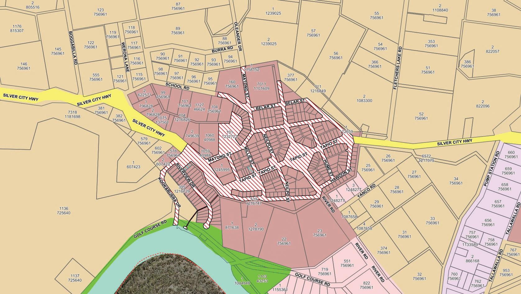


Item 9.14 - Attachment 2 AFZ Dareton Page 324 P.O. Box 81 Wentworth 2648. Tel. (03) 5027 5027 Fax. (03) 5027 5000 E: council@wentworth.nsw.gov.au W: www.wentworth.nsw.gov.au Created by: Matthew Carlin Date: 19/09/2022 Scale: 1:10000 Datum/Projection: GDA94 / MGA zone 54 2022 2022 Nearmap MDBA, Worsley Parsons, Mildura RCC, SunRISE Mapping, Department of State Water, NSW RFS, GeoScience Australia, Western Murray Irrigation Ltd. While every care is taken to ensure the accuracy of this product, Wentworth Shire Council and the Local / State / Federal Government departments and Non-Government organisations whom supply datasets, make no representations or warranties about its accuracy, reliability, completeness or suitability for any particular purpose and disclaims all responsibility and all liability (including without limitation, liability in negligence) for all expenses, losses, damages (including indirect or consequential damage) and costs which you might incur as a result of the product being inaccurate or incomplete in any way and for any reason. * This map is not to be sold or remade as part of a commercial product.
Page 325
9.15 DELEGATED AUTHORITY APPROVALS AS AT END OF AUGUST 2022
File Number: RPT/22/563
Responsible Officer: Matthew Carlin - Director Health and Planning
Responsible Division: Health and Planning Reporting Officer: Kerrie Copley - Administration Officer
Objective: 3.0 Wentworth is a community that works to enhance and protect its physical and natural environment Strategy: 3.1 Ensure our planning decisions and controls enable the community to benefit from development
Summary
For the month of August 2022, a total of eight (8) Development Applications and two (2) S4.55 Modification Applications were determined under delegated authority by the Director Health and Planning.
The estimated value of the determined developments was $1,791,358.00. This brings the year to date total to seventy-one (71) Development Applications and thirty-four (34) S4.55 Applications approved, with an estimated development value of $9,906,529.00
Recommendation
That Council:
a) Receives and notes the report for the Delegated Authority Approvals for the month of August 2022.
b) Publicly notifies, for the purposes of Schedule 1 Division 4 Section 20 (2) of the Environmental Planning and Assessment Act 1979, the applications as listed in the attachment on the Wentworth Shire Council website.
c) Calls a Division in accordance with S375A of the Local Government Act 1993 (NSW).
Detailed Report
Purpose
The purpose of this report is to provide Council with a list of Development Applications as tabled in the Attachment, determined under delegated authority by the Director Health and Planning for the month of August 2022, hence complying with the requirements under section 3.20 of the Office of Local Government Promoting Better Practice Program.
Conclusion
The total value of determinations was $1,791,358.00 for the month of August 2022. The average determination time was 28 days.
Attachments
1. Delegated Authority Approval August 2022⇩
Ordinary Meeting AGENDA 28 September 2022 Page 326

Item 9.15 - Attachment 1 Delegated Authority Approval August 2022 Page 327 DETERMINATION OF DEVELOPMENT APPLICATIONS FOR THE MONTH OF AUGUST 202 2 FILE NUMBER APPLICANT LOCATION DESCRIPTION VALUE (EX GST) DETERMINATION DATE ACTIVE DAYS DA2022/059 PAN 232169 James Golsworthy Consulting Pty Ltd River Road Lot 850 DP 756961 Coomealla Upgrading existing irrigation infrastructure $50,000.00 1/08/2022 48 DA2022/072 PAN 243371 Town Planning HQ Pty LtdAngela Davison Fletchers Lake Road Lot 204 & 205 DP 756961 Coomealla Artificial windbreak structures $83,990.00 2/08/2022 19 DA2022/073 PAN 240979 Emily Duck 20 Mitchell Court Lot 16 DP 1229757 Gol Gol Storage shed $9,200.00 11/08/2022 22 DA2022/074 PAN 245718 Hatch Planning Pty LtdTim Berger 35 Lee Court Lot 47 DP 1259103 Gol Gol Storage shed $20,000.00 12/08/2022 22 DA2022/070 PAN 240051 MH2 Engineering & Architectural Services P/L Silver City Highway Lot 10 DP 756157 Anabranch South Dwelling $590,000.00 18/08/2022 38 DA2022/060 PAN 223348 Brent Williams & Associates P/L Alfred Elms Road Lot 2 DP 1277386 Trentham Cliffs Machinery shedstorage shed & Fertigation shed $671,504.00 22/08/2022 61 S455/2022/035 PAN250071 Mallee ShedsJodie Stockman 5721E Sturt Highway Lot 4 DP 827371 Monak Modify DA2022/042 Storage shedremove Condition 5 $0.00 25/08/2022 10 DA2022/078 PAN 248113 GSD ArchitectsGeoff Sparkes 1298 River Road Lot 2 DP 1214442 Mourquong Colorbond fence $10,000.00 26/08/2022 28 DA2022/075 PAN 231114 Stuart & Beverley Field Pooncarie Road Lot 5 DP 1270097 Wentworth Dwelling & garage $356,664.00 26/08/2022 31
Item 9.15 - Attachment 1 Delegated Authority Approval August 2022 Page 328 DETERMINATION OF DEVELOPMENT APPLICATIONS FOR THE MONTH OF AUGUST 202 2 S455/2022/036 PAN 255126 Danson & BlabyBrad Blaby 60B Darling View Road Lot 2 DP 1121029 Wentworth Modify DA2022/020 2 Lot SubdivisionAmendment of electricity supply condition E4 $0.00 29/08/2022 5
9.16 PROJECT & WORKS UPDATE - SEPTEMBER 2022
File Number: RPT/22/571
Responsible Officer: Geoff Gunn - Director Roads and Engineering
Responsible Division: Roads and Engineering
Reporting Officer: Chanelle Pilling - Administration Officer
Objective:
3.0 Wentworth is a community that works to enhance and protect its physical and natural environment Strategy: 3.2 Ensure that community assets and public infrastructure are well maintained
Summary
This report provides a summary of the projects and major works undertaken by the Roads and Engineering Department which have been completed during the month of August 2022 and the planned activities for September 2022.
Recommendation
That Council receives and notes the major works undertaken in August 2022 and the scheduled works for the following month.
Detailed Report
Refer below for updates of the works completed in August 2022 and the planned activities for September 2022.
Project and Works Update for August 2022
Roads
Road Safety Officer
Projects
• Construction on 8.5km of Old Wentworth Road is continuing with the final layer of road base added to the main section of unsealed road. Awaiting AHIP Approval for middle section later this month prior to final works commencing. Works now due to be completed November 2022.
Pooncarie-Menindee Road Reconstruction
• Council has begun works on the middle section of the PooncarieMenindee Road. Earthmoving, road formation and drainage works continuing.
Maintenance Grading
• Planned maintenance grading was undertaken on the following roads throughout August: Top Hut Nob, Arumpo Road, Polia Road and High Darling Road
Local Traffic Projects
• High Pedestrian Activity Area (HPAA) requests are with Transport for NSW to bid for funding. Once this is confirmed, community consultation on the footprint of the special speed zone can begin.
• Speed zone review requests submitted to Transport for NSW for: Old Wentworth Road and Armstrong Avenue, Wentworth; and Silver City Highway, Gol Gol East.
Ordinary Meeting AGENDA 28 September 2022 Page 329
Projects
Local Government Road Safety Projects
• Heavy Vehicle Road Safety Forum – initial planning for industry focus conducted with Transport for NSW including Almonds and Citrus.
• Drink Driving Plan B Win A Swag – Sponsor for Bar and Beer Garden at Wentworth Show successful. 260 breath tests conducted, 185 entries into Win A Swag and no drink driving infringements reported. Pooncarie Races booked for 1 October 2022 and Wentworth Races booked for 1 November 2022. Two (2) staff required at each event to run campaign. Shuttle Bus funding secured for Pooncarie Races through Transport for NSW seed funding contracted to CDC Bus Company.
Buronga Landfill Machinery Shed
• Waiting on contractor to confirm a start date.
Dareton Library
• Windows have been vandalised and smashed.
• Rear of building is partially boarded up until new glass can be installed.
• Police and Crime Scene Investigators have attended site, Wentworth Shire Council working with insurance company.
George Gordon Oval - Dareton
• New bar/kitchen was broken into, window shutters and glass were broken, alcohol stolen.
• Damage to multiple areas.
• Building contractor has been contracted for repairs.
Gol Gol Cemetery Shed
• Shed construction has been completed.
• Shed drainage and electrical connection have been organised and will be completed by early October.
Gol Gol East Raw Water System
• Procurement of infrastructure components including pumps, filter, chlorination unit and electrical from selected pre-qualified suppliers completed and orders placed.
Junction Island Bridge
• Quote period for Fabrication completed. Fabrication awarded to local fabricators Tub Built Industries. Expected completion date for fabrication early December 2022.
• Quote period for Demolition and Installation works closes 23 September 2022.
Junction Island Footpath
Ordinary Meeting AGENDA 28 September 2022 Page 330
• Draft REF and Aboriginal Cultural Heritage due diligence documents have been completed and are being reviewed.
Pink Lake
• Council is currently developing the final report details into a detailed design package for tender within the new financial year.
Pooncarie Telegraph Building
• Demolition and works Request for Quotes have been sent out to contractors. two quotes received, assessment and awarding of works to be completed early September.
Wentworth EDS
• Detailed design works to be finalised based on the original location of the Wentworth EDS.
Wentworth Horse Racing Track – New Running Rail System
• New SIMTRACK running rail system has been delivered.
• Fencing contractor has been awarded the work of dismantling the old running rail and installing the new SIMTRACK running rail.
Wentworth Jockey Change Rooms – Female
The growing number of female jockeys has brought the need to provide separate facilities across Australian racing venues. Progress to date on an extension to facilitate this need has been:
• Background investigations completed including geotechnical investigation, DA requirements and services.
• Design Development plans previously approved by the Wentworth Racing Club and Racing NSW.
• Construction plans now being prepared for tendering the works.
• Asbestos audit arranged to ascertain any risks prior to construction.
Wentworth Long Day Care Centre
• Outside veranda completed and concrete paving prepared for pouring.
• Walls rendered in preparation for final coloured coat.
• Cabinetry being placed and plumbing fit-off occurring.
• Concrete floors being levelled in preparation for vinyl flooring.
Wentworth Rowing Club Extension
• Delays encountered with the Construction Certificate until a Fire Hydrant can be provided adjacent to the building. In response, a design is progressing to share the new fire tank and pump system proposed for the Caravan Park.
Wentworth Sewerage Rationalisation Scheme
• Final clean up and removal materials continuing with all works expected to be completed by early September 2022.
Ordinary Meeting AGENDA 28 September 2022 Page 331
Roads
Road Safety Officer Projects
Wentworth Sporting Complex
• Tennis Club – Two (2) new split system air conditioners have been installed.
Wentworth Showgrounds Tower and Shade Structures
• Works completed.
Wentworth Swimming Pool
• Tiler has completed works.
Projects and Works scheduled for September 2022
• Construction works on 8.5km of Old Wentworth Road continuing. Wentworth Shire Council awaiting confirmation from Greenedge of AHIP results for the middle section. Bitumen Sealing has been rescheduled for October.
• Continuation of construction works on Little Manly Road – Culverts were installed in August. Sealing is programmed for September.
• Punt Road Gol Gol reconstruction monitored for dust suppression as required until sealing works in late September.
Pooncarie-Menindee Road Reconstruction
• Production of crushed road base material on Tarcoola Station to commence early September.
• Trucks will start carting onto the 1st 5km section of road from mid/late September, with earthworks and final drainage installation continuing on the remaining sections through to the end of September.
Maintenance Grading
• Planned maintenance grading will be undertaken on the following roads throughout September; Nulla Road, Rufus Road and Renmark Road.
Local Traffic Projects
• Assessment for school zones to be conducted by TfNSW for Buronga Public School and Coomealla High School both on Silver City Highway.
Local Government Road Safety Projects
• Free Cuppa for the Driver fatigue campaign under review after 11 years in the market – no campaign for the 2023 season. Transport for NSW have engaged independent consultant to review the project. Fatigue campaign/s to resume in the 2023-24 financial year.
• Child Restraint Checking Day and Caravan Weigh In Day postponed until new Road Safety Officer is appointed.
• Road Safety Officer position to be advertised in September. Interview panel to include Engineering Manager and Transport for
Ordinary Meeting AGENDA 28 September 2022 Page 332
NSW representative early October pending suitable candidates.
Civic Centre
• Tenders being assessed by assessment panel
Dareton Pool – Insurance Works (Vehicle Hit)
• Insurance works to repair damaged building to commence.
Gol
Gol Cemetery Shed
• Drainage and Electrical works to commence, completion scheduled for late September to early October.
Gol Gol East Raw Water System
• Tender for installation and construction of supporting infrastructure including civil & electrical works to be finalised by end September with a report and recommendation to be presented at the Oct Council meeting for approval.
James King Park
• Compilation of REF and Cultural Heritage Due Diligence documents to commence.
Junction Island Bridge
• Quote period for demolition and installation to close, contract to be awarded late September to early October.
Projects
Junction Island Footpath
• Upon sign off of REF, begin procurement process for path and raised boardwalk. Provide request for quotes to local civil construction contractors.
Pink Lake
• While the detailed design works are prepared for tender, Council staff are to liaise with WMI on feedback and approval to connect and discharge to Pink Lake.
• Further soil investigation planned for September through deep sections of the Gol Gol Ridge to determine suitability of trenchless construction.
Wentworth EDS
• Detailed design works are expected to be completed mid to late September.
Wentworth Horse Racing Track – New Running Rail System
• Works complete installation of the new SIMTRACK running rail by late October 2022.
Wentworth Sporting Complex
• Tennis Club & Bowls Club – Bi-Parting doors to be installed in October by Sunraysia Blinds.
Ordinary Meeting AGENDA 28 September 2022 Page 333
Wentworth Showgrounds Sewer
Following the staging of the Wentworth Show, works will recommence on the project in September with installation of new pump station, switchboard, rising sewer main and final connections to existing buildings. All works including commissioning are expected to completed by the second week of October in readiness for the Melbourne Cup race day.
Wentworth Sewerage Rationalisation Scheme
• All works including final removal of materials and clean up of old sewerage treatment plant site to be completed by end of September, completing the project and entering into the 12 months defects liability period.
Wentworth Swimming Pool
• Pool preparation & painting works to be undertaken throughout Willowbend Caravan Park
• Works commenced – the finalization of earthworks shaping and commencement of drainage installation
• Road way construction
• Delivery of water and sewer materials
Attachments
1. Project & Works Photos - Roads & Engineering - September 2022⇩
Ordinary Meeting AGENDA 28 September 2022 Page 334
Project and Works Photos – August 2022


Item 9.16 - Attachment 1 Project & Works Photos - Roads & Engineering - September 2022 Page 335
Drink Driving Plan B – Selfie Frame at Wentworth Show 2022


Item 9.16 - Attachment 1 Project & Works Photos - Roads & Engineering - September 2022 Page 336
Dareton Pool – Vehicle Hit


Item 9.16 - Attachment 1 Project & Works Photos - Roads & Engineering - September 2022 Page 337
Library Damage


Item 9.16 - Attachment 1 Project & Works Photos - Roads & Engineering - September 2022 Page 338
Wentworth Pool


Item 9.16 - Attachment 1 Project & Works Photos - Roads & Engineering - September 2022 Page 339
Pooncarie Menindee Road Reconstruction


Item 9.16 - Attachment 1 Project & Works Photos - Roads & Engineering - September 2022 Page 340
Wentworth Long Day Care Centre
Proposed Jockey Change Room Extension & DDA Compliant Toilet

Item 9.16 - Attachment 1 Project & Works Photos - Roads & Engineering - September 2022 Page 341
Ordinary Meeting AGENDA 28 September 2022 Page 342
Nil
10 NOTICES OF MOTIONS / QUESTIONS WITH NOTICE
11 CONFIDENTIAL BUSINESS – ADJOURNMENT INTO CLOSED SESSION
Despite the right of members of the public to attend meetings of a council, the council may choose to close to the public, parts of the meeting that involve the discussion or receipt of certain matters as prescribed under section 10A(2) of the Local Government Act.
With the exception of matters concerning particular individuals (other than councillors) (10A(2)(a)), matters involving the personal hardship of a resident or ratepayer (10A(2)(b)) or matters that would disclose a trade secret (10A(2)(d)(iii)), council must be satisfied that discussion of the matter in an open meeting would, on balance, be contrary to the public interest.
The Act requires council to close the meeting for only so much of the discussion as is necessary to preserve the relevant confidentiality, privilege or security being protected. (section 10B(1)(a))
Section 10A(4) of the Act provides that a council may allow members of the public to make representations to or at a meeting, before any part of the meeting is closed to the public, as to whether that part of the meeting should be closed.
Section 10B(4) of the Act stipulates that for the purpose of determining whether the discussion of a matter in an open meeting would be contrary to the public interest, it is irrelevant that:-
(a) a person may misinterpret or misunderstand the discussion, or
(b) the discussion of the matter may -
(i) cause embarrassment to the council or committee concerned, or to councillors or to employees of the council, or
(ii) cause a loss of confidence in the council or committee.
Recommendation
That Council adjourns into Closed Session, the recording of the meeting be suspended, and members of the press and public be excluded from the Closed Session, and that access to the correspondence and reports relating to the items considered during the course of the Closed Session be withheld unless declassified by separate resolution.
This action is taken in accordance with Section 10A(2) of the Local Government Act, 1993 as the items listed come within the following provisions:-
12.1 Plant Replacement - Approval for Tenders for Replacement Plant 504
Specialised Road Maintenance Truck VR2223/504. (RPT/22/560)
This item is classified CONFIDENTIAL under the provisions of Section 10A(2) of the Local Government Act 1993, which permits the meeting to be closed to the public for business relating to (c) information that would, if disclosed, confer a commercial advantage on a person with whom the Council is conducting (or proposes to conduct) business. On balance, the public interest in preserving the confidentiality of information about the tender outweighs the public interest in maintaining openness and transparency in council decision-making because disclosure of this information would reveal pricing and confidential information submitted via the tender process which if disclosed would prevent council from achieving its 'value for money' objectives.
12.2 PT2223/02 - Supply of Bulk Automotive Fuel Tender. (RPT/22/562)
This item is classified CONFIDENTIAL under the provisions of Section 10A(2) of the Local Government Act 1993, which permits the meeting to be closed to the public for business relating to (d) (i) commercial information of a confidential nature that would, if
Ordinary Meeting AGENDA 28 September 2022 Page 343
disclosed prejudice the commercial position of the person who supplied it. On balance, the public interest in preserving the confidentiality of information about the item outweighs the public interest in maintaining openness and transparency in council decision-making.
12.3 Bridge Lift and Maintenance - 12 Month Period PT2021/09 Tender Variation. (RPT/22/595)
This item is classified CONFIDENTIAL under the provisions of Section 10A(2) of the Local Government Act 1993, which permits the meeting to be closed to the public for business relating to (c) information that would, if disclosed, confer a commercial advantage on a person with whom the Council is conducting (or proposes to conduct) business. On balance, the public interest in preserving the confidentiality of information about the tender outweighs the public interest in maintaining openness and transparency in council decision-making because disclosure of this information would reveal pricing and confidential information submitted via the tender process which if disclosed would prevent council from achieving its 'value for money' objectives.
12.4 Project Management of the Wentworth Shire Civic Centre Redevelopment by GSD Architects. (RPT/22/610)
This item is classified CONFIDENTIAL under the provisions of Section 10A(2) of the Local Government Act 1993, which permits the meeting to be closed to the public for business relating to (d) (i) commercial information of a confidential nature that would, if disclosed prejudice the commercial position of the person who supplied it. On balance, the public interest in preserving the confidentiality of information about the item outweighs the public interest in maintaining openness and transparency in council decision-making.
Ordinary Meeting AGENDA 28 September 2022 Page 344
12 OPEN COUNCIL - REPORT FROM CLOSED COUNCIL
12.1 PLANT REPLACEMENT - APPROVAL FOR TENDERS FOR REPLACEMENT PLANT 504 SPECIALISED ROAD MAINTENANCE TRUCK VR2223/504
File Number: RPT/22/560
Responsible Officer: Geoff Gunn - Director Roads and Engineering
Responsible Division: Roads and Engineering
Reporting Officer: Lisa Kalemkeridis - Administration Officer
Objective: 3.0 Wentworth is a community that works to enhance and protect its physical and natural environment
Strategy: 3.4 Use and manage our resources wisely
REASON FOR CONFIDENTIALITY
This item is classified CONFIDENTIAL under the provisions of Section 10A(2) of the Local Government Act 1993, which permits the meeting to be closed to the public for business relating to (c) information that would, if disclosed, confer a commercial advantage on a person with whom the Council is conducting (or proposes to conduct) business. On balance, the public interest in preserving the confidentiality of information about the tender outweighs the public interest in maintaining openness and transparency in council decision-making because disclosure of this information would reveal pricing and confidential information submitted via the tender process which if disclosed would prevent council from achieving its 'value for money' objectives.
Ordinary Meeting AGENDA 28 September 2022 Page 345
12.2 PT2223/02 - SUPPLY OF BULK AUTOMOTIVE FUEL TENDER
File Number: RPT/22/562
Responsible Officer: Simon Rule - Director Finance and Policy
Responsible Division: Finance and Policy
Reporting Officer: Simon Rule - Director Finance and Policy
Objective:
4.0 Wentworth Shire is supported by strong and ethical civic leadership with all activities conducted in an open, transparent and inclusive manner
Strategy: 4.5 Adopt practices of prudent asset, financial and human resource management across Council to ensure long-term sustainability and efficiency
REASON FOR CONFIDENTIALITY
This item is classified CONFIDENTIAL under the provisions of Section 10A(2) of the Local Government Act 1993, which permits the meeting to be closed to the public for business relating to (d) (i) commercial information of a confidential nature that would, if disclosed prejudice the commercial position of the person who supplied it. On balance, the public interest in preserving the confidentiality of information about the item outweighs the public interest in maintaining openness and transparency in council decision-making.
Ordinary Meeting AGENDA 28 September 2022 Page 346
12.3 BRIDGE LIFT AND MAINTENANCE - 12 MONTH PERIOD PT2021/09 TENDER VARIATION
File Number: RPT/22/595
Responsible Officer: Geoff Gunn - Director Roads and Engineering Responsible Division: Roads and Engineering Reporting Officer: Chanelle Pilling - Administration Officer
Objective: 3.0 Wentworth is a community that works to enhance and protect its physical and natural environment Strategy: 3.2 Ensure that community assets and public infrastructure are well maintained
REASON FOR CONFIDENTIALITY
This item is classified CONFIDENTIAL under the provisions of Section 10A(2) of the Local Government Act 1993, which permits the meeting to be closed to the public for business relating to (c) information that would, if disclosed, confer a commercial advantage on a person with whom the Council is conducting (or proposes to conduct) business. On balance, the public interest in preserving the confidentiality of information about the tender outweighs the public interest in maintaining openness and transparency in council decision-making because disclosure of this information would reveal pricing and confidential information submitted via the tender process which if disclosed would prevent council from achieving its 'value for money' objectives.
Ordinary Meeting AGENDA 28 September 2022 Page 347
12.4 PROJECT MANAGEMENT OF THE WENTWORTH SHIRE CIVIC CENTRE REDEVELOPMENT BY GSD ARCHITECTS
File Number: RPT/22/610
Responsible Officer: Ken Ross - General Manager
Responsible Division: Office of the General Manager Reporting Officer: Gayle Marsden - Executive Assistant
Objective: 1.0 Wentworth Shire is a vibrant, growing and thriving Region Strategy: 1.2 Promote the Wentworth Region as a desirable visitor and tourism destination
REASON FOR CONFIDENTIALITY
This item is classified CONFIDENTIAL under the provisions of Section 10A(2) of the Local Government Act 1993, which permits the meeting to be closed to the public for business relating to (d) (i) commercial information of a confidential nature that would, if disclosed prejudice the commercial position of the person who supplied it. On balance, the public interest in preserving the confidentiality of information about the item outweighs the public interest in maintaining openness and transparency in council decision-making.
Ordinary Meeting AGENDA 28 September 2022 Page 348
19 October 2022
Ordinary Meeting AGENDA 28 September 2022 Page 349
13 CONCLUSION OF THE MEETING NEXT MEETING