


WENTWORTH SHIRE COUNCIL PLAN OF MANAGEMENT FOR SEVENTY-THREE CROWN RESERVES AND
SIX COUNCIL OWNED COMMUNITY LAND RESERVES
This Plan of Management (PoM)has been prepared by Wentworth Shire Council for 73 Crown Reserves and 6 Council-owned community land areas across the Local Government Area (LGA).
It was referred to the Landowner, the Minister for Crown Lands, on [date, year] to enable public exhibition.
Following public exhibition and consideration of submissions the PoM will be adopted by Council with Ministerial approval.
Wentworth Shire Council acknowledges that within its Local Government Area boundaries are the Traditional Lands of the Indigenous Barkandji people. Council will work collaboratively with the Barkandji people to protect and preserve sites of heritage and cultural significance.
Wentworth Shire Council acknowledges the Traditional Owners of the land and pays respect to Elders past, present and emerging.
This Community Land Plan of Management (PoM) for Wentworth Shire Council is a first PoM prepared for the LGA under the Crown Land Management Act 2016 (CLM Act). It comprises Crown reserves previously managed by the Council as Reserve Trust Manager under the repealed Crown Land Act 1989 and Council-owned community land.
Located in the far south-west of New South Wales, bordering Victoria and South Australia, Wentworth Shire (the Shire) is positioned at the intersection of the National Land Transport Network (Sturt and Calder Highways) connecting the eastern cities of Brisbane, Sydney and Canberra with Melbourne, Adelaide and Perth.
Wentworth Shire encompasses an area of approximately 26,000 square kilometres and is the meeting place of Australia’s largest and most iconic river systems – the Darling and the Murray river. The Darling and Murray Rivers intersect the arid and semi-arid landscape, running north to south and east to west, respectively.
These two river systems are the single most influential feature driving land use and activity in Wentworth Shire and shape the economy, livelihood, identity and history of the community and the environment. 1
The majority of Wentworth Shire residents enjoy a rural lifestyle, and yet are still only 10 to 30 minutes from the regional centre of Mildura, a city of more than 30,000 people.
1 Local Strategic Planning Statement 2020
The Shire is sparsely populated with approximately 7,000 people mostly located in and around the townships of Wentworth, Dareton, Buronga and Gol Gol. The smaller remote town of Pooncarie is located approximately 120km north of Wentworth on the Darling River.
Aboriginal and/or Torres Strait Islander people make up approximately 10% of the Wentworth Shire’s population compared to the NSW State and Australian average of roughly 3%. The Barkandji people are the main First Nation’s people in the Shire. The Barkandji nation of far west NSW holds native title for over 128,000 square kilometres of land, of which a significant proportion is located within Wentworth Shire under the Barkandji Native Title Group Aboriginal Corporation. 2
The Shire’s climate is semi-temperate and lends itself to a diverse industry sector; the top three being agriculture, mining and manufacturing
Within the Shire is Willandra Lakes World Heritage Area encompassing Mungo National Park. This land is of great significance to three local First Nation’s cultural groups: the Paakantyi, Mutthi Mutthi and Ngyiampaa. It is recognised for cultural, archaeological, landscape, biodiversity and research values at a global scale, and social, economic and recreational values at the state and regional level.
Uniquely, most land across the Shire is owned by the Crown, but administered by NSW Department of Planning, Industry and Environment – Crown Lands through Western Lands lease agreements.

The meeting of the two rivers – Darling & Murray Rivers
Wentworth Shire Council has developed broad plans and policies that have an effect on the management of community land. These documents have been considered when preparing this PoM:
• Council’s Community Strategic Plan 2017 – 2027
• Local Strategic Planning Statement A vision to 2040 And Beyond
Council’s Community Strategic Plan 2017 – 2027 (CSP) was developed by the community to achieve the vision of:
A thriving region, supported by a robust economic base, distinctive open spaces, and strong local governance and leadership.
The CSP sets out the aspirations of the Community and the strategic actions to get there.
The Strategic Goals of the CPS are to make Wentworth a:
a) Vibrant, growing and thriving shire;
b) Desirable shire to visit, live, work and invest;
c) Community that works to enhance and protect its physical and natural assets; and
d) Caring, supportive and inclusive community that is informed and engaged in its future.
This PoM for Crown and community land reserved for parks, sportsground, general community use and natural areas will aim, where relevant, to support and contribute towards achieving the following CSP strategies
• Grow visitation to the Shire by developing a quality visitor experience and promoting the destination
• Maintain/create desirable open spaces and recreation facilities
• Plan for and develop the right assets and infrastructure
• Prepare for natural disasters, biosecurity risks and climate change
• Reduce, reuse and recover waste
• Promote disability inclusion within the community
On 18 March 2020 Wentworth Shire Council adopted its Local Strategic Planning Statement A Vision to 2040 And Beyond (LSPS) setting out a 20 year vision for land use, thus planning for Wentworth Shire Council’s economic, social and environmental needs.
The LSPS provides a snapshot of population, land use and economic trends and includes a structure plan, as well as settlement and township plans to manage growth and guide improvements and investment. The LSPS therefore addresses issues of strategic significance to the Shire and identifies planning priorities and actions, spatial land use direction and guidance.
The LSPS gives effect to the Far West Regional Plan 2036 implementing directions and actions at a local level. It is additionally informed by other State-wide and regional policies including Future Transport Plan 2056 and the NSW State Infrastructure Strategy 2018 – 2038
The Council’s Community Strategic Plan (CSP) works concurrently with the LSPS to deliver the community’s vision for the Shire. The planning priorities and actions identified in the LSPS provide the rationale for decisions about the use of land in order to achieve the community’s broader goals
The way in which the following planning priorities may be implement in this PoM are set out in Table 1
Table 1 Local Strategic Planning Statement Priorities relevant to Crown and Council-owned community land
Planning Priority in the LSPS
Grow tourism
Collaborate and partner with First Nation’s communities
Infrastructure and services
Preserve and promote heritage
Manage natural hazards and climate change risks
Protect areas of environmental value
Crown reserves and Council-owned community land contribution
The natural area parks and reserves offer places for tourism facilities and recreational opportunities
Build a greater understanding of the Indigenous communities in managing the reserves
Crown land and council-owned community land support infrastructure and provide community facilities to create healthy built environments that contribute to liveability
Several of the reserves comprise items of environmental and/or cultural heritage
Land and facilities may be located in areas of risk, such as flooding, or could incorporate new sustainable technologies (heating/cooling, water design and reuse etc) to reduce risk and cost
The reserves and council-owned land may be used as biodiversity offsets for future development providing resources to assist with ongoing upkeep of assets and land.
On a State level, Crown Land 2031: State Strategic Plan for Crown Land was released in June 2021. This 10 year plan proposes to activate Crown land to grow tourism, support community groups, boost regional economies, advance Aboriginal interests, and provide more green open space.
Crown land is public land and the plan sets the direction for the estate to support activities to create social, economic, cultural and environment benefits.
The vision embodied in this plan is for:
Crown land to support resilient, sustainable and prosperous communities across NSW.
The priorities for Crown land over the next 10 years are to:
• Strengthen community connections with Crown land
• Accelerate economic progress in regional and rural NSW
• Accelerate the realisation of Aboriginal land rights and native title in partnership with Aboriginal people
• Protect cultural heritage on Crown land
• Protect environmental assets, improve and expand on green space and build climate change resilience
These priorities will be supported by a set of outcomes to be achieved over the early, middle and full decade of the plan with detailed timelines and implementation plans to follow which may be of use to Council in delivering this PoM.
The Local Government Act 1993 (LG Act) requires a Plan of Management (PoM) to be prepared for all public land that is classified as ‘community’ land under the LG Act.
A PoM is an important management tool written by Council in consultation with the community. It outlines the land’s features, and clarifies how the council will manage, use or develop the land in the future. A PoM provides a transparent and coordinated approach to public land management.
A PoM can be prepared for more than one parcel of land (generic or geographic) or for a single property (significant or specific). This is a generic plan for community land which covers multiple reserves.
Community land is land owned or controlled by the Council and recognised as an important component of the environment; providing opportunities for recreation, leisure and contact with the natural environment. It may include a wide variety of properties, ranging from small recreation reserves to iconic parks and buildings.
Community land is valued for its important role in the social, intellectual, spiritual and physical enrichment of residents, workers, and visitors to the Wentworth Shire Council area
The LG Act defines five categories of community land.
1. Park - areas primarily used for passive recreation.
2. Sportsground - areas where primary use is for active recreation involving organised sports or the playing of outdoor games.
3. General Community Use - all areas where the primary purpose relates to public recreation and the physical, cultural, social, and intellectual welfare or development of members of the public. This includes venues such as community halls, scout and guide halls, and libraries.
4. Cultural Significance - areas with Aboriginal, aesthetic, archaeological, historical, technical, research or social significance.
5. Natural Area - all areas that play an important role in the area’s ecology. This category is further subdivided into bushland, escarpment, foreshore, watercourse and wetland categories.
All Community Land must be assigned to one or more LG Act community land ‘categories’ which define how Council will manage each parcel of land. Each category has a set of guidelines for assigning categories and core objectives in providing guidance to the management of community land. The core objectives for each category give a broad strategic direction for management of this land, which is the same for all community land of the same category across NSW.
The CLM Act requires that assignment of community land categorisations to Crown reserves have close regard for the reserve’s purpose. The reserve purposes for the 73 reserves within this PoM are listed in Appendix A1
3.1 What land is covered by this Plan of Management?
The land covered by this Plan of Management (PoM) is identified in schedule Appendix A1 –Crown Reserves and Appendix A2 – Council-Owned. These include Crown reserves managed as community land by Council as the Crown Land Manager, as well as Councilowned community land.
The land covered by this document is defined by real property identifiers (lots and deposited plans), as well as shown by maps in Appendix B
The land on these reserves has been categorised as one or more of the following:
• Park;
• Sportsground;
• General Community Use; or
• Natural Area – Bushland and Natural Area – Watercourse
Each of these categories have specific objectives which shape what can occur on the land, and these are detailed under the relevant section/chapter of this PoM
3.2 What land is not covered by this Plan of
This PoM does not include:
• Community land covered by specific PoMs (adopted under Local Government (LG) or Crown Land (CL) legislation);
• Council-owned operational land as these do not require a PoM;
• Crown reserves that Council manages as ‘devolved land’ and that is managed under Section 48 of the LG Act (Council is not a Crown Land Manager for these reserves), the reserves are not community land and these do not require a PoM;
• Public open space and recreation facilities which are owned and managed by other entities and not managed by Council;
• Privately owned land, which is made available for public use; and
• Land declared as critical habitat, or directly affected by a threat abatement plan or a recovery plan under threatened species laws (sections 36A(2) and 36B(3)) or by Council to contain significant natural features (section 36C(2)) or to be of cultural significance (section 36D(2)).
The LG Act requires community land to be managed and used in accordance with an adopted PoM.
This PoM is a document covering most of the community land and open space within the Wentworth Shire Council LGA categorised as Park, Sportsground, General Community Use and Natural Area (further categorised into bushland and watercourse).
Community land in Wentworth Shir e, in addition to Council-owned public land, includes Crown reserves managed by Council as community land.
The land to which this PoM applies is listed/catalogued in Appendix A1 and Appendix A2
Many Crown reserves in NSW were previously managed by councils on behalf of the NSW Government under reserve trust structure. Now, under the CLM Act, Crown reserves are managed by councils, but remain Crown land and are managed as if they were ‘public land’.
This PoM applies to Crown reserves where Wentworth Shire Council was appointed Crown Land Manager on the commencement of the CLM Act in 2018, and also includes other community land owned by Council.
A single cohesive plan enables consistent management of the open space network and enhanced appreciation by the wider community of its benefits, variety and distribution.
The purpose of this PoM is to:
• Contribute to Wentworth Council’s broader strategic goals and vision as set out in the Wentworth Community Strategic Plan 2017 – 2027;
• Ensure compliance with the Local Government Act 1993;
• Provide clarity in the future development, use and management of the community land; and
• Ensure consistent management that supports a unified approach to meeting the varied needs of the community.
Wentworth Shire Council has developed User Groups for reserves with multiple occupations. These groups have a Councillor representative and have developed Operational Management Plans over the years
There are six reserves that have existing Management Plans or Masterplans. These have been prepared by consultants, or jointly prepared by stakeholders in conjunction with Council for:
• George Gordon Oval;
• Carramar Drive Oval;
• Great Murray Darling Junction Reserve;
• James King Park;
• Wentworth Showground Complex; and
• Thegoa Lagoon; and
• Pooncarie Sporting Reserve.
These Management or Master Plans are not Plans of Management prepared under the LG Act and the CLM Act. They do however serve to provide an integrated framework for the management and development of the land by Council and the Community The directions, recommendations and intent of these management and master plans have been recognised, and the intent included or the outcomes are enabled in this PoM where they are consistent with it
Carramar Drive Oval Reserve 91386
The primary legislation affecting how community land is managed or used is briefly described below.
You can find more information about these Acts at www.legislation.nsw.gov.au
Crown reserves are land set aside on behalf of the community for a wide range of public purposes, including environmental and heritage protection, recreation and sport, open space, community halls, special events and government services.
Crown land is governed by the CLM Act, which provides a framework for the state government, local councils and members of the community to work together to provide care, control and management of Crown reserves.
The CLM Act requires Councils to manage Crown land as public land under the LG Act. This land must be managed in accordance with its purpose and cannot be used for other activity incompatible with this – for example, Crown land assigned the purpose of ‘environmental protection’ cannot be used in a way that compromises its environmental integrity.
Councils must also manage Crown land in accordance with the principles of Crown land management outlined in the CLM Act. The principles are the key values that guide Crown land management benefiting the community and to ensure that Crown land is managed for sustainable, multiple uses.
4.1.1
• Environmental protection principles are to be observed in the management and administration of Crown land.
• The natural resources of Crown land (including water, soil, flora, fauna and scenic quality) will be conserved wherever possible.
• Public use and enjoyment of appropriate Crown land are to be encouraged.
• Where appropriate, multiple uses of Crown land should be encouraged.
• Where appropriate, Crown land should be used and managed in such a way that both the land and its resources are sustained.
• Crown land is to be occupied, used, sold, leased, licensed or otherwise dealt with in the best interests of the state of NSW, consistent with the above principles.
4.1.2
In addition to management and use of Crown reserves that aligns with the reserve purpose(s), there are other influences over council management of Crown reserves. For example, Crown Land Managers may have conditions attached to any appointment instruments, or councils may have to comply with specific or general Crown land management rules that may be published in the NSW Government Gazette. Councils must also comply with any additional or newly made Crown Land Regulation.
There are no conditions attached to any Crown Land Manager appointment notices, and only one Crown land management rule applies to Crown land in Wentworth Shire Council
The rule, made under s.3.15 of the Crown Land Management Act 2016 3 states:
3 https://www.industry.nsw.gov.au/__data/assets/pdf_file/0011/205994/clmr1801-circulartelecommunications-holdings.pdf
Crown land managers cannot, under any act (including the Local Government Act 1993), grant any lease or licence authorising:
• the installation or construction of communication infrastructure on Crown land;
• the placement of communication infrastructure on Crown land;
• the use of communication infrastructure that is located on Crown land;
• access to communication infrastructure that is located on Crown land.
However, the rule does not prevent the holder of a holding granted by t he Minister administering the Crown Land Management Act 2016 subletting of communication infrastructure located on Crown land in accordance with the conditions of a holding granted by the Minister.
Section 35 of the LG Act provides that community land can only be used in accordance with:
• The PoM applying to that area of community land;
• Any law permitting the use of the land for a specified purpose or otherwise regulating the use of the land; and
• The provisions of Division 2 of Chapter 6 of the Act.
Section 36(3) of the Act provides that a PoM for community land must identify the following:
a) The category of the land;
b) The objectives and performance targets of the plan with respect to the land;
c) The means by which the council proposes to achieve the plan’s objectives and performance targets;
d) The manner in which the council proposes to assess its performance with respect to the plan’s objectives and performance targets;
And may require the prior approval of the council to the carrying out of any specified activity on the land.
Land is to be categorised as one or more of the following:
a) A Natural Area;
b) A Sportsground;
c) A Park;
d) An Area of Cultural Significance; or
e) General Community Use.
Land that is categorised as a Natural Area is to be further categorised as one or more of the following: Bushland, Wetland, Escarpment, Watercourse, Foreshore, or a category prescribed by the Regulation.
The Commonwealth Native Title Act 1993 (NT Act) recognises and protects native title rights and interests. The objects of the NT Act are to:
• Provide for the recognition and protection of native title;
• Establish ways in which future dealings affecting native title may proceed and to set standards for those dealings;
• Establish a mechanism for determining claims to native title; and
• Provide for, or permit, the validation of past acts invalidated because of the existence of native title.
The NT Act may affect use of Crown land, particularly development and granting of tenure. In particular, the CLM Act makes it mandatory for council to engage or employ a Native Title Manager. This role provides advice to Council as to how the Council’s dealings and activities on Crown land may be valid or not valid under the NT Act.
Council must obtain written advice from an accredited Native Title Manager so that council complies with any applicable provisions of the native title legislation when:
a) Granting leases, licences, permits, forestry rights, easements or rights of way over the land;
b) Mortgaging the land or allowing it to be mortgaged;
c) Imposing, requiring or agreeing to covenants, conditions or other restrictions on use (or removing or releasing, or agreeing to remove or release, covenants, conditions or other restrictions on use) in connection with dealings involving the land; and
d) Approving (or submitting for approval) a pom for the land that authorises or permits any of the kinds of dealings referred to in (a), (b) or (c).
Crown land is subject to native title rights and interests under the NT Act which must be considered unless:
• Native title has been extinguished; or
• Native title has been surrendered; or
• determined by a court to no longer exist.
Dealings in land or water that affect (impair or extinguish) native title are referred to as ‘future acts’ and these acts must be done in compliance with the NT Act. The NT Act specifies procedures that must be followed before future acts can be done legally.
Some examples of acts which may affect native title on Crown land or Crown reserves managed by Council include:
• the construction of new buildings and other facilities such as toilet blocks, walking tracks, tennis courts, grandstands and barbecues.
• the construction of extensions to existing buildings.
• the construction of new roads or tracks.
• installation of infrastructure such as powerlines, sewerage pipes, etc.
• the creation of an easement.
• the issue of a lease or licence.
• the undertaking of major earthworks.
On Crown land, a future act undertaken by Council, which is not covered by one of the Future Act subdivisions of the NT Act will be invalid.
No future act can be undertaken on Crown reserves within this plan of management unless:
• the lands become, or are excluded land for the purposes of the Crown Land Management Act 2016, or
• the act is a tenure which satisfies the requirements of Section 24HA (Management of Water and Airspace) of the Native Title Act 1993, or
• the act is either pre-existing right-based acts, or permissible renewals of leases, licences, permits or authorities which satisfies the requirements of Section 24I (renewals and extensions etc) of the Native Title Act 1993, or
• the act is a future act which satisfies the requirements of Subdivision J (Reservations, leases, etc) Sections 24JA or 24JB of the Native Title Act 1993, or
• the act is a public work which satisfies the requirements of Section 24KA of the Native Title Act 1993, or
• the act is a low impact act and satisfies the requirements of Section 24LA of the Native Title Act 1993.
Any act authorised under Section 24LA of the Native Title Act 1993 will terminate, after an approved determination of native title is made in relation to the land or waters, if the determination is that native title exists.
Council has developed Plans and Policies that have a bearing on the management of community land. These documents have been considered in preparing this PoM.
• Wentworth Local Environmental Plan 2011;
• Wentworth Development Control Plan 2011;
• Wentworth Community Strategic Plan 2022 – 2032:
• Wentworth Community Engagement Strategy 2020, and
• Wentworth Local Strategic Planning Statement 18 March 2020 (see section 2.2)
Wentworth Local Environmental Plan 2011
The Wentworth Local Environmental Plan 2011 (W LEP) applies to the entire LGA and sets out the land use zones and controls for development under the Environmental Planning and Assessment Act 1979
The W LEP identifies the reserves managed by the Council as one of or a combination of the following land use zones:
RU1 Primary Production
RU5 Village
RE1 Public Recreation
RE2 Private Recreation
W1 Natural Waterways
W2 Recreational Waterways
SP2 Infrastructure
These zones set objectives and define permitted and prohibited development on the land. The zones applying to the 73 Crown reserves are provided in Appendix A1.
Several land use zones given to some of the reserves are not compatible with the underlying Crown land purpose of public recreation. These will need to be amended when the W LEP is next updated
Development or uses within the reserves requiring a Development Application will be assessed under Section 4.15 of the Environmental Planning and Assessment Act 1979 and in accordance with the LEP.
In addition to the permitted and prohibited development set out in the land use zones, the LEP has special provisions which need to be considered for works within the reserves dependant on their location. These provisions relate to:
• Flooding;
• Heritage;
• Biodiversity;
• Wetlands;
• Development on river frontages;
• Riparian land, Murray River and other watercourses; and
• River bed and banks of the Murray River.
The following Reserves have European Environmental Heritage listing in the LEP:
Locality Reserve Number Property Description
Anabranch 84989
Curlwaa 630011
Anabranch Hall Local 11
Curlwaa Memorial Hall Local 122
Gol Gol 1005288 Gol Gol Cemetery Local 126
Pooncarie 35698
Pooncarie 230096
Wentworth 1036648
Wentworth 85572
Wentworth 89749
Wentworth 1034808
Wentworth 84700
Pooncarie Cemetery Local 135
Police Station and Post Office Local 135 and 136
Wentworth Town Hall Local 144
Old Wentworth Gaol State 150
Junction Park Local 154
Wentworth Cemetery Local 153
Wentworth Wharf Local 161
Wentworth 87379 PS Ruby within Fotherby Park Local 173
Wentworth 55602
Wentworth Water Tower within Great Murray Darling Junction Reserve Local 196
Development or works on these reserves will need to consider clause 5.10 of the WLEP.
Willandra Lakes World Heritage Area (Mungo National Park) is a Heritage Conservation Area within Wentworth LGA however, it is not a reserve for which W entworth Council has responsibility over but is part of the NSW National Parks system.
There is significant First Nation’s cultural heritage in the region and within several of the Natural Area reserves including Perry Sandhills, Thegoa Lagoon and Great Murray Darling Junction Reserve. Preparation of a site-specific PoM will be considered for these reserves in the future subject to the need to consult with Aboriginal communities and Council resolution to declare these Areas of Cultural Significance under the LG Act.
Wentworth DCP 2011 is a supporting guiding document which development must also consider.
In summary, the possible impacts of any future proposal on reserve land will be considered in light of all relevant planning controls and Council policies and must be consistent with the public purpose given to the land
Other state and federal legislation of relevance to the use of the land is in Appendix C.
Figure 1 below illustrates the process of preparing this PoM.
Figure 1: Process steps in preparing this plan of management
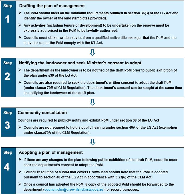
Source: State government template 2021
Community consultation is important to ensure a PoM meets the needs of the local community It enables the comprehensive management of public land and encourages appreciation of its social, environmental and health benefits.
In accordance with section 39 of the Local Government Act 1993, prior to being placed on public exhibition, the draft PoM was referred to the Department of Planning and Environment, as representative of the state of NSW, which is the owner of the 73 Crown reserves in this PoM. Council has included in the plan any provisions that have been required by the Department of Planning and Environment – Crown Lands.
As part of the initial referral of the draft PoM to the Minister, and in accordance with the CLM Reg Cl. 70B - Modification of the Local Government Act 1993, section 40, Council also sought the written consent of the Minister for Council to adopt the plan of management after public exhibition.
On 13 November 2020, stakeholder engagement was held with key users, representatives and lessees, by way of an email survey and advice informing these users of the preparation of the draft PoM.
Other engagement options were limited due to the (then) COVID 19 restrictions.
The survey explored the importance and value of the reserves, what improvements could be made, what issues exist and potential solutions, to confirm existing and future uses and document desired future outcomes. The outcomes of this early engagement have been incorporated into this draft PoM.
A list of the stakeholders is at Appendix D
Note: Council has developed User Groups for reserves with multiple occupations. These groups have a Councillor representative and have developed Operational Management Plans which to date have provided the detail for the daily management of the site/facility.
The CLM Act and Regulation no longer require a public hearing if the community land categories assigned to Crown reserves are amended after Council's Notice of Initial Assignment.
The LG Act does require a public hearing for Council-owned community land, or parts of community land where categories are assigned for the first time or amended.
The Council-owned community land requiring a public hearing are:
1. Car Park Midway Centre
2. Midway Centre
3. Second Oval – land being Lot 2, DP 1239025, adjacent to George Gordon Oval (Crown Reserve 61503)
4. Civic Centre
5. Wilkinson Hall
6. Little Manly
Such a public hearing is typically held during the public exhibition of the relevant draft PoM and provides the community with the opportunity to make formal comment on the categorisation change within the draft PoM.
A public hearing was held in relation to this PoM on [insert details of public hearing, including date and venue], in accordance with the requirements of Sections 40(A) and 47(G) of the LG Act, as the PoM proposes to add a category on LG Act community land for the first time in a PoM.
The Plan will be placed on public exhibition for 28 days plus a 14-day ongoing response period (42 days total) [insert dates] in accordance with the LG Act. The exhibition period allows for interested parties to comment on the draft PoM. [Council to consider comments, and if needed amend the final document where appropriate]
Key comments were reviewed and are tabulated below.
The 73 Crown Reserves across the Wentworth Shire LGA are widely dispersed and range from sportsgrounds, childcare, cemeteries, caravan parks, to bushland and parks. These are important open space, recreation, cultural and social resources catering to a wide range of local and regional activities.
Council is responsible for the management of the reserves, and resources this management through:
• Administration and bookings staff;
• Dedicated maintenance and operations staff including parks and reserve operational teams;
• Licensee or lessee maintenance responsibilities, improvements, facility or site presentation as set out in detailed and formal licence or lease user agreements; and
• Advice to council on management, operations, and maintenance through a LG Act section 355 committee of management.
Council will plan for and undertake structural repairs, facility upgrades and facility renewals in accordance with its adopted asset management plans, budgets and capital works programs.
Council provides funding for the upkeep and development of the Crown reserves through consolidated revenue allocations in Council's Operational Plan and associated budgets, use of open space revenues from fees and charges, grant funding and capital developments using sponsorship, and partner funding.
The Roads and Engineering Department is responsible for the care and control, maintenance and upgrading of the parks and reserves in the Wentworth Shire LGA.
Unless otherwise determined, Council is responsible for the external structural integrity of facilities, except where a user group has a detrimental impact upon the external condition of the building.
Council maintains a dedicated works staff that undertake a range of maintenance and use management activities on the parks and reserves including mowing, rubbish management and removal, repairs and minor improvements to infrastructure and facilities.
Council and tenants will partner with a co-operative approach to the asset responsibilities and costs.
Licensees and user groups allocate volunteer and organisational resources and f unds to develop and maintain their lease/license areas, buildings and structures.
Unless otherwise determined, users of the facility should be responsible for the internal maintenance of the facility. Where more than one group uses a facility, contributions and responsibility for maintenance should be shared based on the floor space usage ratio.
Council provides funding assistance and undertakes maintenance work (repairs and replacement) on community halls and other community buildings/amenities and sports facilities as the budget allows.
In addition to the evaluation of planning and development proposals that affect or use Council's parks and reserves, Council's Health and Planning Department is responsible for the development of Plans of Management which will assist in the long-term management and potential future development of these reserves.
The LG Act requires that any lease, licence or other estates over community land must be expressly authorised by a PoM. They must be consistent with the LG Act and category core objectives, as well as the Crown reserve's purpose(s), in the best interests of the community as a whole and enable, wherever possible, shared use of community land. The term ‘other estates’ includes other interests, charges, rights or titles in relation to the land, for example an easement.
A lease is a contract between a landowner or manager and another entity, granting that entity a right to occupy an area for a specified period of time for agreed purposes. The main difference between a lease and licence is that a licence does not permit the sole, or exclusive, use of the area. Licences may be granted to formally recognise and endorse shared uses. For example, a sportsground is used in the summer for playing cricket and in the winter for Australian Rules Football. Licences can include conditions relating to the handover at the end of the playing season. Licences are commonly used for sports facilities such as a club house.
In accordance with the requirements of the LG Act, this PoM expressly authorises Council to grant a lease, licence or other estate on community land when:
• The activity is consistent with this PoM;
• The agreement is consistent with the core objectives for the categories of Park, Sportsground, General Community Use and Natural Area;
• The agreement is on a Crown reserve, the uses of the land are consistent with the reserve's purpose(s); and
• The lease, licence or other estate is for a purpose listed in the Tables in each Development and Use Section of this Plan of Management.
Any lease or licence proposal will be individually assessed and considered, including the community benefit, compatibility with this PoM, gazetted purpose of the reserve and the capacity of the area to support the activity. Where legally permissible, tenures in relation to Crown reserves may be issued in accordance with the LGA and/or the CLM Act
Section 46 LG Act permits Council to grant a lease, licence or other estate on community land, without an adopted Plan of Management for:
• The provision of public utilities and works associated with or ancillary to public utilities; or
• The purpose of providing pipes, conduits or other connections under the surface of the ground for the connection of premises adjoining the community land to a facility of the council or other public utility provider.
6.1.1 Maximum time period for leases or licences over any community land covered by this plan of management
The maximum period for any lease or licence is 30 years (including any option) and Minister’s consent is required if the lease/licence exceeds 21 years (Sect 47(5)(b)). Unless exempt by the regulations, all such leases, licences or grant of other estate must be advertised and the community notified in accordance with the provisions of sections 47 and 47A of the LG Act.
The grant of any tenures, e.g: tenure terms and limits, tendering, and notification and approvals, will be subject to the provisions of Part 2, Division 2 of the LG Act.
Council must call tenders for leases or licences over 5 years, unless the lease or licences is to be granted to a non-profit organisation, (s.46A).
Subleases are only allowable for the same purpose as the original lease, except for a handful of exceptions listed in cl.26, Local Government (General) Regulation.
Council may only grant exclusive occupation of community land through a lease, licence or other estate.
For leases between 5 and 21 years council must:
• give public notice of the proposal
• place a notice of the proposal on the land
• notify owners adjoining the land
• notify persons living in the vicinity of the land if the council believes that the land “is the primary focus of the person’s enjoyment of community land”
• consider submissions made about the proposal
• refer the proposal to the Minister for Local Government if council has received an objection to the proposal.
If an objection has been received, the council cannot grant the lease etc but must refer the proposal to the Minister for approval.
Table 2 below outlines purposes for which tenure may be granted on community land categorised as Sportsground, Park and General Community Use. Refer to section 7.2 for Natural Areas.
Table 2 Leases, licences and other estates and purposes for which they may be granted for community land categorised as Sportsground, Park and General Community Use.
Type of tenure arrangement
Lease
Purpose for which tenure may be granted
• Use and management of field, course, court facilities and buildings and fixtures that provide for sports uses
• Food and beverage outlets, such as restaurants, café/kiosk areas, including seating and tables
• Hire or sale of sports or recreational equipment childcare facilities that provide for sportsground users
• Health and fitness goods and services for sportsgrounds users and visitors
• Café/kiosk areas, including seating and tables
• Management of park areas and facilities
• Hire or sale of recreational equipment
• Community recreation, leisure and cultural activities
• Child care or vacation care
• Health or medical practitioners associated with the relevant facility (for example, nutrition, physiotherapy)
• Educational purposes, including libraries, education classes, workshops
• Community services purposes
• Cultural purposes, including concerts, dramatic productions and galleries
• Recreational purposes, including fitness classes, dance classes and games
• Sporting uses developed/operated by a private operator
• Kiosk, café and refreshment purposes
• Commercial retail uses associated with the facility (e.g. Sale or hire of sports goods)
• Caravan parks and camping grounds
• Emergency services purposes
Licence
• Use and management of field, course, court facilities and buildings and fixtures that provide for sports uses
• Outdoor café/kiosk seating and tables
• Hire or sale of sports or recreational equipment
• Health and fitness goods and services for sportsgrounds users and visitors
• Outdoor café/kiosk seating and tables
• Management of court or similar facilities
• Hire or sale of recreational equipment
• Social purposes (including child care, vacation care)
• Educational purposes, including libraries, education classes, workshops
• Community services purposes
• Emergency services purposes
• Recreational purposes, including fitness classes, dance classes
• Café/kiosk areas
• Sale of goods or services that are ancillary to community land use and reserve purpose, for example flower sales at cemetery
Short-term licence
Subject to:
General and ad hoc shortterm or casual licences: as issued ad hoc with Council formal application process, permissions and/or approvals (LG Act, S.46, LG (General) Regulation, Cl.117, and CLM Act Ss. 2 20 and 3.17, CLM Regulation Cl. 31
• Sporting fixtures and events
• Sports and fitness training and classes
• Ancillary ceremonies (for example, rehearsal of opening and closing ceremonies, cheer squads, etc.)
• Access through a reserve
• Advertising
• Broadcasting or filming of sporting fixtures
• Commercial photographic sessions and filming (as defined in the Local Government Act 1993)
• Delivery of a public address
• Emergency occupation
• Entertainment
• Equestrian events
• Exhibitions
• Hiring of equipment
• Markets
• Picnics and private celebrations such as weddings and family gatherings
• Catering
• Playing of a musical instrument, or singing, for fee or reward
• Playing of a lawful game or sport
• Sales
• Shows
• Site investigations
• Stock agistment or grazing
• Community events and festivals
• Playing a musical instrument, or singing for fee or reward
• Picnics and private celebrations such as weddings and family gatherings
• Filming, including for cinema/television
• Conducting a commercial photography session
• Public performances
• Engaging in an appropriate trade or business
• Delivering a public address
• Fairs, markets, auctions and similar activities
• Hiring of equipment
• Catering
• Playing of a lawful game or sport
• Sales
• Shows
• Site investigations,
• Public speeches, meetings, seminars and presentations, including educational programs
• Functions (including commemorative functions, book launches, film releases, balls, and similar activities)
• Displays, exhibitions, fairs, fashion parades and shows
• Events (including weddings, corporate functions, and community gatherings)
• Concerts and other performances, including both live performances and film (cinema and TV)
• Broadcasts associated with any event, concert, or public speech
• Engaging in an appropriate trade or business delivering a public address, community events; auctions, markets and similar activities
Other estates
• Storage associated with sporting events or use agreements
• Limited area function uses reasonably associated with the promotion or enhancement of sporting groups, fixtures and events (for example, ‘‘guest’ events for juniors; gala days; club meetings)
• Stock agistment or grazing
• This PoM allows the council to grant ‘an estate’ over community land for the provision of public utilities and works associated with or ancillary to public utilities in accordance with the LG Act.
• Estates may also be granted across community land for the provision of pipes, conduits, or other connections under the surface of the ground for the connection of premises adjoining the community land to a facility of the council or other public utility provider that is situated on community land.
The LG Act imposes restrictions on the ability of Council to grant leases, licences or other estates over community land categorised as Natural Area and further sub-categorised as Bushland, Wetland, Escarpment, Watercourse or Foreshore
Council may only grant a lease, licence or other estate over Natural Area category land if:
• It is authorised under the PoM;
• The purpose is consistent with the core objectives for that category of land;
• The uses of the land are consistent with the reserve's purpose(s); and
• The lease/ licence is for a purpose specified in section 47B of the LG Act (as below).
Section 47B restricts the grant of a lease, licence or other estate that would enable the erection of structures or buildings to only the use or erection of these listed below:
• W alkways;
• Pathways;
• Bridges;
• Causeways;
• Observation platforms; or
• Signs.
Council is able to authorise the erection and use of those buildings or structures for the following purposes:
• Information kiosks;
• Refreshment kiosks (but not restaurants);
• Work sheds or storage sheds required in connection with the maintenance of the land; or
• Toilets or rest rooms.
While these structures are permitted to be constructed on community land categorised as Natural Area, a development application may also be required prior to their construction in accordance with the Environmental Planning and Assessment Act 1979
It is noted however, that the legislation does not restrict the use of the land or the issue of a lease or licence in a Natural Area category for activities such as walking tours, environmental tours, bushcare, canoe hire etc.
See section 7.2 for Leases and Licenses authorised by this PoM for Natural Areas.
6.1.3 Existing Leases and Licences on land in this PoM
Council has existing agreements previously granted for use and occupation of land with this PoM: short-term licences, licences and leases, for Crown reserves and Council-owned community land.
A list of short-term licences, licences and leases is in Appendix A3
When planning to grant a lease or licence, the council must comply with the requirements of the Commonwealth Native Title Act 1993 (NT Act) and have regard for any existing claims made on the land under the NSW Aboriginal Land Rights Act 1983.
It is the role of Council’s engaged or employed Native Title Manager to provide written advice in certain circumstances to advise if the proposed activities and dealings are valid under the NT Act. Wentworth Shire Council has received Native Title Manager advice and considered the advice prior to referral of the draft PoM to the Landowner: the Minister administering the Crown Land Management Act 2016
Dealings in land or water that effect (impair or extinguish) native title are referred to as ‘future acts’ and these Acts must be done in compliance with the NT Act. Granting a lease or licence over Crown land may be a future act.
Certain types of future acts can be validated under the NT Act. Where future acts are undertaken, native title claimants and holders may be entitled to specific procedural and substantive rights. As such, the written advice of a Native Title Manager is required. The advice must state that the act complies with the NT Act, and any necessary procedural requirements must be fulfilled prior to the act taking place.
Wentworth Shire Council LGA is a party to the Barkandji # 8 Native Title Claim Determination with a date of judgement of 2015 and 2017. Council has been working closely with the Prescribed Body Corporate (PBC) of the Traditional Owners and their legal representative Native Title Services Corporation (NTSCORP) to develop an Indigenous Land Use Agreement (ILUA). This process is currently paused, but if an ILUA is registered, Council will have an agreed process to consult the Traditional Owners for any future act that could affect their Native Title Rights.
This PoM will require regular review in order to align with community values and changing community needs, and to reflect changes in council priorities. Typically, PoMs are updated every five years, with a more comprehensive re- write after ten years.
Council's four year Operational Plans, and Delivery Plans may impact on the priorities of PoM actions being implemented, however this PoM will be a major support to the capital and operation funds expenditure, as well as regular operational maintenance expenditure.
The performance of this PoM will be reviewed on a regular basis to ensure that community land is well maintained and provides a safe environment for public enjoyment. Council should regularly monitor and evaluate the progress of implementation and review of performance targets, means of achievement and method of assessment annually.
Any change to an adopted PoM will require the preparation of a new draft PoM, which may be a simple alteration to the existing schedules and text or change of category from Park to General Community Use or Sportsgrounds.
Each new draft PoM must be referred to the landowner and placed on public exhibition where the Community will have an opportunity to comment prior to Council adoption.
6.5 ‘Deemed’ Landowner’s Consent under the Crown Land Management Act 2016 and Development under Transport & Infrastructure SEPP 2021
Crown Land Managers (CLMs) are responsible for upgrading and replacing infrastructure, buildings and facilities, with a view to maximising the life of their assets. The scale and requirements of any infrastructure development will depend on Council's resources, assets, and perceived public demand or need.
Under the Environmental Planning and Assessment Act 1979 (EP&A Act), ‘development’ includes:
• Erecting a building;
• Carrying out works;
• Demolishing a building or work;
• Subdividing land; or
• Changing the use of land.
The EP&A Act regulates development in NSW and has established a framework for the control and assessment of development proposals. This consists of environmental planning instruments, which contain the development controls, and an application, assessment and approval process. The application, assessment and approval process differs according to the nature and scale of the development proposed.
Deemed Land Owner's Consent
Proposed development that requires approval under Part 4 of the EP&A Act, requires Land Owner’s Consent (LOC) for a Crown Land Manager or tenure holder to lodge a development application (DA) on Crown land, unless a development type is covered under section 2.23 of the Crown Land Management Act 2016 (CLM Act).
Section 2.23 of the CLM Act has introduced low impact development types where the Minister responsible for the CLM Act is taken to have given land owner’s consent on behalf of the Crown to make a development application (DA) under Part 4 of the EP&A Act ('deemed land owner's consent').
A Deemed Land Owners Consent fact sheet provides further guidance for CLMs or tenure holders looking to apply section 2.23 of the CLM Act. 4
Minister taken to give consent for certain development applications over dedicated or reserved Crown land
These provisions apply to dedicated or reserved Crown land for the purposes of the Environmental Planning and Assessment Act 1979 and any instrument made under that Act and has effect despite anything in that Act or instrument under that Act.
2.23(2) The Minister is taken to have given written consent on behalf of the Crown (as the owner of dedicated or reserved Crown land) for its Crown Land Manager or the holder of a lease or licence over the land to make a development application relating to any of the following kinds of development:
4 Attachment-A-Crown-Land-Manager-Fact-Sheet-2.23-Deemed-LOC.pdf (nsw.gov.au)
Minister taken to give consent for certain development applications over dedicated or reserved Crown land
(a) without limiting paragraph (g), the repair, maintenance, restoration or renovation of an existing building on the land if it will not do any of the following
(i) alter the footprint of the building by adding or removing more than one square metre (or any other area that may be prescribed by the regulations),
(ii) alter the existing building height by adding or removing one or more storeys,
(iii) involve excavation of the land,
(b) The erection of a fence approved by the Manager or the repair, maintenance or replacement of a fence erected with the Manager’s approval,
(c) The use of the land for any of the following purposes
(i) a purpose for which the land may be used under this Act,
(ii) a purpose for which a lease or licence has been granted under this Act,
(d) The erection of signage approved by the Manager or the repair, maintenance or replacement of signage erected with the Manager’s approval,
(e) The erection, repair, maintenance or replacement of a temporary structure on the land,
(f) The installation, repair, maintenance or replacement of services on the land,
(g) The erection, repair, maintenance or replacement of any of the following on the land
(i) a building or other structure on the land permitted under the lease,
(ii) a toilet block,
(iii) a structure for the protection of the environment,
(h) The carrying out on the land of any other development of a kind prescribed by the regulations or permitted under a Plan of Management for the land
(3) Subsection (2) [The above] conditions do not apply in relation to any development that involves any of the following:
(a) The subdivision of land,
(b) The carrying out of development of a kind excluded by the Regulations.
(5) To avoid doubt, the Minister’s Consent on behalf of the Crown (as the owner of dedicated or reserved Crown land) to lodgement of a development application in respect of that land is required for the carrying out of any development to which subsection (2) does not apply.
Development of a kind excluded by the CLM Regulation 5
For the purposes of section 2.23 (3) (b) of the CLM Act development involving the erection, repair, maintenance or replacement of services is excluded if the development
5 Crown Land Management Regulation 2018 Part 2 Use of Crown Land, Division 2 General: 14 When Minister taken to give consent for certain development applications over dedicated or reserved Crown land
Minister taken to give consent for certain development applications over dedicated or reserved Crown land
is not being carried out principally for the benefit of the dedicated or reserved Crown land to which the development application relates.
For the purposes of section 2.23 (3) (b) of the Act, the carrying out of development within a domestic waterfront precinct is excluded unless:
(a) The development involves the repair or maintenance of an existing lawful building or other structure, and
(b) The development does not involve the excavation of land, and
(c) The building or structure (as repaired or maintained) does not change any of the following
(i) Any interruption of water flow caused by the existing building or structure,
(ii) the height of the existing building or structure,
(iii) the above water footprint of the existing building or structure.
Note:
Domestic waterfront precinct means:
(a) Submerged dedicated or reserved Crown land (including the bed of a river or estuary) that is within the coastal waters of the State, and
(b) Dedicated or reserved Crown land that is not submerged, but adjoins
(i) Submerged dedicated or reserved Crown land above the mean high-water mark for tidal land, or
(ii) The bank of a river, creek or lake.
State Environmental Planning Policy (Transport and Infrastructure) 2021 replaced SEPP (Infrastructure) 2007 however it continues to list development allowed with consent or without consent on community land.
The SEPP assists the NSW Government, private infrastructure providers, Local Councils and the Communities they support by simplifying the process for providing infrastructure like hospitals, roads, railways, emergency services, water supply and electricity delivery.
This SEPP overrides most other environmental planning instruments under the EP&A Act including local environmental plans, regional environmental plans, and other State environmental planning policies.
It designates a number of types of infrastructure and works as ‘development permitted without consent’ when they are carried out by public authorities.
Where a Council CLM proposes to carry out such development, and that development involves the construction of large or significant permanent structures on a Crown reserve (for example, roads, car parks, visitors’ centres, maintenance depots, outdoor recreation facilities such as skate parks, etc), the Council must notify the Crown Land agency in writing of the details of the development prior to carrying out the activity.
Crown Land Manager and Crown Managed Land have the same meaning as in the Crown Land Management Act 2016
Public Reserve has the same meaning as it has in the Local Government Act 1993 but does not include a Crown reserve that is dedicated or reserved for a public cemetery.
2.73
Development for any purpose may be carried out without consent on Crown managed land, by or on behalf of a Council Crown Land Manager (Council CLM) of the land if the development is for the purposes of implementing a Plan of Management adopted for the land under the LG Act
(3) Any of the following development may be carried out by or on behalf of a council without consent on a public reserve under the control of or vested in the council
(a) development for any of the following purposes
(i) roads, pedestrian pathways, cycleways, single storey car parks, ticketing facilities, viewing platforms and pedestrian bridges,
(ii) recreation areas and recreation facilities (outdoor), but not including grandstands,
(iii) visitor information centres, information boards and other information facilities,
(iv) lighting, if light spill and artificial sky glow is minimised in accordance with the Lighting for Roads and Public Spaces Standard,
(v) landscaping, including landscape structures or features (such as art work) and irrigation systems,
(vi) amenities for people using the reserve, including toilets and change rooms,
(vii) food preparation and related facilities for people using the reserve,
(viii) maintenance depots,
(ix) portable lifeguard towers,
(b) environmental management works,
(c) demolition of buildings (other than any building that is, or is part of, a State or local heritage item or is within a heritage conservation area).
Note — The term building is defined in the Environmental Planning and Assessment Act 1979 as including any structure.
(1) Development for any of the following purposes that is carried out in the prescribed circumstances is exempt development
(a) construction or maintenance of
(i) walking tracks, raised walking paths (including boardwalks), ramps, stairways or gates, or
(ii) bicycle-related storage facilities, including bicycle racks and other bicycle parking facilities (except for bicycle paths), or
(iii) handrail barriers or vehicle barriers, or
(iv) ticketing machines or park entry booths, or
(v) viewing platforms with an area not exceeding 100m2, or
(vi) sporting facilities, including goal posts, sight screens and fences, if the visual impact of the development on surrounding land uses is minimal, or
(vii) play equipment if adequate safety measures (including soft landing surfaces) are provided and, in the case of the construction of such equipment, so long as the equipment is situated at least 1.2m away from any fence, or
(viii) seats, picnic tables, barbecues, bins (including frames and screening), shelters or shade structures, or
(ix) portable lifeguard towers if the footprint of the tower covers an area no greater than 20 square metres,
(b) routine maintenance of playing fields and other infrastructure, including landscaping,
(c) routine maintenance of roads that provide access to or within those playing fields, including landscaping.
(2) Development is carried out in the prescribed circumstances if the development is carried out
(a) on land referred to in section 2.73(1) by or on behalf of a public authority, or
(b) on land referred to in section 2.73(2)(a) or (b) by or on behalf of the Centennial Park and Moore Park Trust or the Parramatta Trust, as the case may be, or
(c) in connection with a public reserve (other than Crown managed land) by or on behalf of a public authority, or
(d) on Crown managed land, by or on behalf of
(i) the Secretary, or
(ii) a Crown land manager of the land (or an administrator of the manager), or
(iii) the Ministerial Corporation, or
(iv) a council having control of the land under section 48 of the Local Government Act 1993, or
(v) the Minister administering the Crown Land Management Act 2016. Development is exempt development under this clause only if the development:
(a) Complies with clause 20 of the SEPP, and
(b) Involves no greater disturbance of native vegetation than necessary, and
(c) Does not result in an increase in stormwater run- off or erosion.
Please refer to the full and current version of the SEPP on the legislation website: https://legislation.nsw.gov.au/
Natural Area Reserves will be managed as an integral component of the overall community open space system in Wentworth Shire LGA. The guiding management principle will be to preserve remnant Bushland and Watercourses and to manage them in keeping with natural ecological processes while facilitating public enjoyment and use by all age groups, subject to available resources.
7.1.1 Definition
Natural Areas are defined in LG Regulation 102 as:
Land, whether or not in an undisturbed state, possesses a significant geological feature, geomorphological feature, landform, representative system or other natural feature or attribute that would be sufficient to further categorise the land as bushland, wetland, escarpment, watercourse or foreshore
7.1.2 Core Objectives
The management of community land is governed by the categorisation of the land, its purpose, and the core objectives of the category.
The core objectives for Natural Areas, as outlined in Section 36E of the LG Act, are to:
(a) Conserve biodiversity and maintain ecosystem function in respect of the land, or the feature or habitat in respect of which the land is categorised as a Natural Area; and
(b) Maintain the land, or that feature or habitat, in its natural state and setting; and
(c) Provide for the restoration and regeneration of the land; and
(d) Provide for community use of and access to the land in such a manner as will minimise and mitigate any disturbance caused by human intrusion; and
(e) Assist in and facilitate the implementation of any provisions restricting the use and management of the land that are set out in the Threatened Species Conservation Act 1995 (repealed and replaced by Biodiversity Conservation Act 2016) or the Fisheries Management Act 1994. 6
These higher order core objectives are given specific expression within each of the subcategories in this PoM for Natural Area – Bushland and Natural Area – Watercourse.
6 The Threatened Species Conservation Act 1995 has been repealed and replaced with the Biodiversity Conservation Act 2016
There are 20 Crown reserves with a category of Natural Area – Bushland or Natural Area
Watercourse in part or whole
These are listed in section 7.3 and section 7.4 respectively.
There are several threatened and endangered species throughout the LGA, however the land covered by this PoM is not known to contain critical species. Council proposes to continue the sustainable management of these natural features and supporting habitats. Future ecological studies will inform the ongoing management and development of any of the Crown land managed by Council where such proposals have an ability to disturb natural features and habitats or if it is required for integrated and long-term sustainable management.
The most pressing environmental matters for the future identified in Council’s State of Environment (SoE) Report 2015/16 relevant to the reserves were:
• Climate change - increase in number and severity of storm events;
• Flood;
• Drought;
• Management of Murray Darling Basin/Riverine environment;
• Waste management/recycling;
• Pest animals/weeds; and
• Irrigation water/supply/allocations.
The SoE also identified the following environmental attributes for three Crown Reserves
Does council maintain any land for the purposes of biodiversity or the environment?
If so, how much land is reserved?
Is this land protected from activities such as four-wheel driving and fire wood collection?
Yes The following reserves are used for both public recreation and have Management Plans for the preservation of the natural environment and biodiversity:
• Perry Sandhills Reserve
• Thegoa Lagoon Reserve
• The Great Murray Darling Junction
Thegoa Lagoon Reserve is approximately 294 hectares
Perry Sandhills Reserve is approximately 97 hectares
The Great Murray Darling Junction 9.31 hectares
Thegoa Lagoon has a number of 4WD tracks, which is not permitted, and firewood collection is also prohibited. Council prefers that visitors use the graded track(s)
Perry Sandhills prohibits vehicle access over the hills but vehicle access is permitted around the base of the site and firewood collection is prohibited
The Great Murray Darling Junction provides for pedestrian access only and firewood collection is prohibited
Wentworth Shire Council was appointed Manager of Thegoa Lagoon Reserve, 30 November 1956. Council continues to work cooperatively with groups with an interest in Environmental and Heritage Conservation and Protection. For example, Murray Darling Wetlands Working Group, Landcare and the Thegoa Lagoon Management Steering Group together prepared the 2003-2006 Thegoa Lagoon Management Plan and Tourism Pamphlet Council’s guiding management principle will be to conserve remnant bushland and rehabilitate degraded areas while facilitating public enjoyment and use by all; subject to available resources. Subject to funding, a future site-specific Management Plan may be prepared for this significant reserve.
Regarding Section 36C of the LG Act, ‘Community Land containing significant natural features’: it is confirmed that no land within this PoM contains any community land that is the subject of a resolution by Council declaring that the land, being the site of a known natural, geological, geomorphological, scenic or other feature to which this section applies, is:
• Considered by the Council to warrant protection or special management considerations, or
• A wildlife corridor.
Further to the registration of the Barkandji # 8 Native Title Determination Council has sought to build a mutually cooperative relationship with the PBC of the Traditional Owners. Council has in place a number of steps when considering disturbance of Aboriginal Artefacts including:
• Council undertaking Heritage Information Management System (AHIMS) searches in the planning stages of proposed works W here possible Council would avoid excavation in identified areas:
• During construction: the engagement of Cultural Heritage Monitors through NTSCORP. The role of the Monitors is to observe the public work being constructed to ensure that any disturbed Aboriginal Artefacts are treated with respect; and
• Continuing to meet with and progress the proposed ILUA.
The LG Act requires that any lease, licence or other estates over community land must be expressly authorised by a PoM.
Table 3 below expressly authorises leases and licenses and other estates for the purposes for which tenure may be granted on community land categorised as Natural Area.

Perry Sandhills Reserve 97997
Table 3. Leases, licences and other estates and purposes for which they may be granted for community land categorised as Natural Area
Type of tenure arrangement
Lease
Licence
Purpose for which tenure may be granted
• Walkways, pathways, bridges, causeways
• Observation platforms, signs
• Information kiosk
• Kiosk selling light refreshments (but not restaurants)
• Bicycle/boat hire or similar
• Work sheds or storage sheds required in connection with the maintenance of the land
• Toilets
• Temporary erection or use of any building or structure necessary to enable a filming project to be carried out
• Carbon sequestration
• Bio-banking
• Soil erosion and water quality management
• Walkways, pathways, bridges, causeways
• Observation platforms, signs
• Information kiosk
• Kiosk selling light refreshments (but not restaurants)
• Bicycle/boat hire or similar
• Work sheds or storage sheds required in connection with the maintenance of the land
• Toilets
• Temporary erection or use of any building or structure necessary to enable a filming project to be carried out
• Scientific studies and surveys or similar
• Guided walking tours, guided interpretive tours
• Environmental and scientific study
• Approved bush care projects requiring ecological restoration activities associated with protection of flora and fauna.
• Fire hazard reduction
• Soil erosion and water quality works
Short-term licence
Other estates
• Scientific studies and surveys or similar
• Guided walking tours, guided interpretive tours
• Environmental and scientific study
• Approved bush care projects requiring ecological restoration activities associated with protection of flora and fauna.
• Fire hazard reduction
• Soil erosion and water quality works
• Bicycle/boat hire or similar
• Temporary erection or use of any building or structure necessary to enable a filming project to be carried out
This PoM allows the Council to grant ‘an estate’ over community land for the provision of public utilities and works associated with or ancillary to public utilities in accordance with the LG Act
Estates may also be granted across community land for the provision of pipes, conduits, or other connections under the surface of the ground for the connection of premises adjoining the community land to a facility of the Council or other Public Utility Provider that is situated on community land
7.3.1 Introduction and Core Objectives
This section has been prepared in accordance with the LG Act, to regulate the use and management of land categorised as Natural Area – Bushland. The land covered by this section is either owned by Council and classified as Community Land or is a Crown Reserve over which Council is the appointed Crown Land Manager. Refer to Appendix A1 and A2 for categorisation details for each reserve and individual land parcels. Where a site has been divided into multiple categories ( Appendix B) e.g: Natural Area and Park, this section applies only to that part categorised as ‘Natural Area’. The remaining area will be covered by the PoM for the residual category, e.g: 'Park'.
7.3.1.1 Definition
Bushland is defined in LG Regulation 2005 clause 107(1)(a) and 107(1)(b) as:
Land containing primarily native vegetation that is the natural vegetation or a remainder of the natural vegetation of the land, or although not the natural vegetation, is still representative of the structure or floristics of the natural vegetation in the locality.
7.3.1.2 Core Objectives
These are given specific meaning in the core objectives for Bushland, as outlined in Section 36J(a)-(g) of the LG Act, which are to:
• Ensure the ongoing ecological viability of the land by protecting the ecological biodiversity and habitat values of the land, the flora and fauna of the land and other ecological values;
• Protect the aesthetic, heritage, recreational, educational and scientific values of the land;
• Manage the land in a manner that protects and enhances the values and quality of the land and facilitates public enjoyment of the land, and to implement measures to minimise or mitigate disturbance caused by human intrusion;
• Restore degraded bushland;
• Protect existing landforms such as natural drainage lines, watercourses and foreshores;
• Retain bushland in parcels of a size and configuration that will enable the existing plant and animal communities to survive in the long term; and
• Protect bushland as a natural stabiliser of the soil surface.
Pooncarie Multi-Purpose Park & Golf Course Reserve 230081
Natural Areas in Wentworth Shire Council LGA are predominately dry land intersected by the Darling and Murray Rivers with regular drought and flood cycles. The Bushland has unique characteristics which differ depending on the cycle.
The following reserves have a category of Natural Area – Bushland, in whole or part, over the land:
• Reserve 55602 The Great Murray Darling Junction Reserve
• Reserve 63988 Buronga Caravan Park
• Reserve 64544 Part Buronga Caravan Park
• Reserve 74478 Evans Flat Reserve
• Reserve 76798 Part Buronga Caravan Park
• Reserve 78438 Ramon Deed Retreat
• Reserve 85470 Gol Gol Public Recreation Reserve
• Reserve 78909 Thegoa Lagoon
• Reserve 87037 Pooncarie Public Reserve
• Reserve 87250 Buronga Riverfront old Pound Reserve
• Reserve 87379 Fotherby Park
• Reserve 89749 Junction Park
• Reserve 91386 Carramar Drive Sporting Complex
• Reserve 97997 Perry Sandhills
• Reserve 230004 Part Thegoa Lagoon
• Reserve 230005 Ambulance Station site within Thegoa Lagoon
• Reserve 230044 Pooncarie Public Reserve
• Reserve 230081 Pooncarie Multi-Purpose Park and Golf Course
• Reserve 1003148 Coomealla Memorial Gardens
The State Environmental Planning Policy (Biodiversity and Conservation) Chapter 2 regulates clearing of native vegetation in urban local government areas, as well as urban environmental zones across the state, where clearing does not otherwise require development consent under the EP&A Act.
Under this SEPP, a permit is required from Council to clear native vegetation in the reserves zoned as RU5 Village, RE1 Public and RE2 Private Recreation and SP2 Infrastructure within Wentworth Shire. Other conditions apply and there are some exemptions.
State and federal environmental laws require that certain types of development that impact on the environment must procure ‘environmental offset credits’ to achieve overall balance. Some Crown land with high environmental values can be used to generate offset credits.
Additionally, there are state programs that encourage land being used to maximise biodiversity and conservation. Opportunities include creating new dedications for conservation purposes, changing the way the land is managed to make it eligible for offset credits, and entering conservation agreements. Wentworth Shire Council could explore this avenue which ultimately could provide funds to help with the upkeep and maintenance of the reserves.
7.3.2
Generally, bushland is under increasing pressure from climate change, bushfire, weeds, pests and diseases, utility infrastructure, domestic animals, motorbikes, vehicles, vandalism and edge effects, such as from urban interface
Common threats to biodiversity include land clearing, invasive plants species and feral and pest animals.
The habitat and native wildlife in each of the Natural Area – Bushland have the potential to be affected by rabbits, European red foxes, goats, wild pigs and feral cats.
National threat abatement plans exist for these species and identify the research, management and other actions needed to ensure the long-term survival of native species and ecological communities affected by predation and/or habitat disturbance
Control or eradication of these species, weed contr ol and appropriate management of the reserves will support its ecological health and clean air, water and soil.
These bushland reserves are also fire prone and appropriate management of the reserves, particularly those close to residential areas, is needed.
Within the Shire are critically endangered species and ecological communities identified under the Commonwealth Environment Protection and Biodiversity Conservation Act 1999, and the NSW Biodiversity Conservation Act 2016, along with other threatened plants and animals. At the time of writing this PoM none of these were known to occur on the Crown land.
Natural areas specific management issues have been developed to help define the action plans in this PoM ensuring that community land is maintained and managed in a sustainable way. These are set out in Table 5 below.
Table 5 Natural Area Issues
The need for strategic management
Limited participation by small sections of the community in the management of Natural Areas
Limited but dispersed nature of natural areas to manage and conserve
The potential for Aboriginal heritage sites to be located on lands which have been previously unsurveyed
Council’s natural areas require a strategic approach to account, budget, prioritise and manage for the large area of land categorised as Natural Area.
A need to promote increased structured opportunities for community participation in the management of Natural Areas (i.e., Bush care groups) and to promote environmental education.
Increasing the community’s awareness to the importance of natural areas is one of the best ways to ensure the proper future management of these declining ecosystems.
The dispersed nature of Natural Area sites (Bushland and Watercourse) to be maintained throughout the LGA places pressure on the allocation of resources to ensure that such sites are managed in accordance with the principles of Ecologically Sustainable Development and Council’s resources.
Many of the Natural Areas under Council’s care and control are largely undisturbed. In addition, there are many adjacent to a river, lagoon or other water source which is where Aboriginal persons congregated.
Local Archaeologists and Aboriginal Persons continue to complete the references documentation requirements to register Aboriginal Heritage sites in the Aboriginal Heritage Information System (AHIMS).
Invasion of exotic flora and fauna
Exotic species invade natural areas and out-compete the native species interrupting ecosystem integrity and threatening biodiversity.
Vandalism and the illegal dumping of rubbish
As many natural areas are surrounded by high-usage residential, commercial and industrial areas, they tend to become subject to vandalism by the way of flora destruction, arson and the dumping of rubbish on all scales from littering to building waste. Removal of wood continues to be an issue.
Fire
Threatened Species, Threatened Ecological Communities and Key Threatening Process Management
Bushfire at the inappropriate frequency and temperature can result in the disruption of the life cycle processes in native plants and animals and loss of vegetation structure and therefore must be managed accordingly. The risk of fire adversely affecting community or environmental assets within or adjacent to natural areas must be managed in accordance with the Bush Fire Risk Management Plan and Bush Fire Operations Plan.
Council coordinates an active Local Emergency Management Committee (LEMC) with representation from NSW Fire and Rescue and the NSW Rural Fire Service (RFS). The RFS document Planning for Bush Fire Protection (PBP) was adopted in 2019. PBP 2019 is a document prepared by NSW RFS that sets out the bushfire management requirements for developing on bushfire prone land (see Source Planning Circular PS20-001 March 2020).
Wentworth Shire contains many threatened flora and fauna species and ecological communities that are listed under the Biodiversity Conservation Act 2016. As Local Land Managers, Council must ensure that proper environmental management systems are in place to promote the recovery of such species and ensure their existence in association with the National Parks and Wildlife Service and in accordance with the Biodiversity Conservation Act 2016
Where community land comprises the critical habitat of threatened species as declared by the Biodiversity Conservation Act 2016 or the Fisheries Management Act 1994 a site specific PoM will be required for that area.
Recreation and visitor usage of Natural Areas
Pressures on Natural Areas from urban interface
Many of council’s natural areas are frequented by a high percentage of the community, particularly the bushland. The number of people which use these areas can place pressures on the natural environment.
However, the opportunity also exists to provide interpretive educational walks and eco-tourism opportunities.
Areas of bushland, scrub, sandhills and waterways bordering the urban interface face greater exposure and pressure from the surrounding areas. Pressures are increased due to invasion of weeds from garden escapees and predator pressures from exotic species such as cats. These edge effects generally decrease with an increase in distance from the urban interface. Other pressures on the bushland ecosystem and biodiversity because of close proximity to urban areas include rubbish dumping, arson, vandalism, uncontrolled access, stormwater and nutrient and pesticide runoff. These factors all contribute to the deterioration of the quality of natural areas.
The use and development of community land should be compatible with the legislated purpose of the land and the wider community context.
Wentworth Shire Council encourages a wide range of uses of its community land and intends to facilitate uses which increase the activation and utilisation of its land.
The general types of uses which may occur on community land categorised Natural Area –Bushland, and the forms of development generally associated with those uses, are set out in Table 6 below.
The anticipated uses and associated development identified in the table are intended to provide a general guide. The facilities on community land may change over time, reflecting community needs.
Table 6 Permissible use and development of community land categorised as Bushland
Purpose/Use
• Preservation of the Council’s Natural Heritage including any identified endangered ecological communities
• Preservation of biological diversity and habitat
• Providing a location for relaxation and passive informal recreation
• Walking/hiking
• Guided bushwalks and interpretive tours
• Environmental and scientific study
• Bush regeneration works
• Carbon sequestration
• Bio-banking
• Approved bush care projects requiring ecological restoration activities associated with protection of flora and fauna.
• Fire hazard reduction
• Soil erosion and water quality
• Pushbikes on designated tracks
Development to facilitate uses
• Visitor facilities: toilets, picnic tables, BBQs, sheltered seating areas, lighting, low impact carparks, refreshment kiosks (but not restaurants)
• Low-impact walking and bicycle trails
• Interpretive signage, information kiosks
• Water-saving initiatives such as rain gardens, swales and sediment traps
• Bridges, observation platforms, boardwalks, signs
• Work sheds or storage sheds required in connection with the maintenance of the land
• Temporary erection or use of any building or structure necessary to enable a filming project to be carried out or for specific one off events
• Locational, directional and regulatory signage
7.3.4 Management Framework for Natural Areas Categorised as Bushland
The bushland in the Wentworth LGA is either dry land or adjacent to a river. Dry land consists of Mallee Eucalypt species which typically grow with multiple stems springing from an underground lignotuber. These species can grow up to 10 metres in height.
Bushland adjacent to an aquatic environment typically consists of Red Gum, Coolabah and Box trees. These Floodplain Woodlands can tolerate flooding and long dry periods.
Council’s objectives in managing these areas will be to:
• Identify and incorporate these reserves into the wider open space and recreational network for the enjoyment of the community and visitors;
• Conserve ecological habitats;
• Restore and rehabilitate bushland areas;
• Preserve natural geological features;
• Introduce a community access and education program;
• Manage the reserves as a buffer between other uses/development and waterbodies;
• Reduce threat to life and property by fire; and
• Seek funding and use limited available resources efficiently and effectively
Section 36(3) of the LG Act requires that a PoM for Community Land details:
(a) The category of the land,
(b) The objectives and performance targets of the plan with respect to the land,
(c) The means by which the council proposes to achieve the plan’s objectives and performance targets, and
(d) The manner in which the council proposes to assess its performance in achieving the plan’s objectives and performance targets.
However, this may require the prior approval of the Council to the carrying out of any specified activity on the land. Table 7 sets out these requirements for community land categorised as Bushland.
Table 7 Objectives and performance targets, means of achieving them and assessing achievement for community land categorised as Bushland
Management Issues
1.1 Ecological habitats being preserved and managed.
s.36(3)(b) Objectives and Performance Targets
No loss of existing habitat and regeneration of the natural bushland encouraged.
s.36(3)(c) Means of Achievement of Objectives
Undertake bushland restoration projects that foster natural seeding and regeneration.
Where native seed banks remain in the soil, it is preferable to use fire, ripping of the soil or other techniques to encourage natural regeneration.
Locally occurring indigenous plants that have been recorded within the reserve/s are used in restoration works.
Retain hollow logs and living hollow bearing trees.
Investigate opportunities to use Crown reserves to generate off set credits.
s.36(3)(d) Manner of Assessment of Performance
Number and type of bushland restoration projects carried out.
Amount of natural regeneration occurring.
Number of native endemic species planted.
Hollow logs and hollow bearing trees remain untouched in the reserves
Liaison with NSW Government agencies to further develop and provide opportunity for the natural areas of the Local Government Area.
Eligibility of key reserves is assessed for their potential to provide off set credits and funding.
1.2 Manage the land consistent with recovery of threatened species, populations and ecological communities
s.36(3)(b)
Objectives and Performance Targets
Implement sympathetic habitat management in crown reserves where the Hooded Robin (south-eastern form) and Black-chinned Honeyeater (eastern subspecies) occur.
Minimise human disturbance at identified key foraging sites of the Black tail Godwit (disturbance from 4WDs, recreational users, dog-walkers, fishermen etc).
Fence sites to prevent grazing (domestic stock, rabbits and kangaroos), slashing and soil compaction and pugging.
Within the reserves, manage total grazing pressure through such actions as removal of artificial water points.
1.3 Manage noxious weeds, feral and pest animals.
Protect the habitat values of the land by encouraging responsible pet management and limit the effects of invasive animals on native wildlife and vegetation
s.36(3)(c)
Means of Achievement of Objectives
Identify the extent of threatened plant and animal species within the reserves to support recovery programs and for funding purposes.
Where feasible fence sites to protect local plant populations and seed banks of threatened grasses, herbs and shrubs
s.36(3)(d)
Manner of Assessment of Performance
Number of recovery strategies implemented in accordance with the State Priority Actions for the Shire 7
Amount of natural regeneration occurring.
Extent of fencing erected and number of artificial water sources removed.
Council and the Community undertake a program of Community Environment Days to eradicate the reserves of weeds and pest animals
Number of volunteers attending community events on the reserves to help protect its biodiversity.
Regular treatment and reduction in weeds, pest animals (goats, foxes, rabbits) and feral cats
Maintenance works are required to consolidate regenerated areas.
Off leash dogs are not permitted in Natural Areas.
Healthy floristic community.
7 https://www.environment.nsw.gov.au/topics/animals-and-plants/threatened-species
s.36(3)(b)
Objectives and Performance Targets
1.4 Bushfire Management. Review Bush Fire Management and determine the most appropriate fire regime for vegetation on these reserves near to assets (e.g homes and infrastructure)
1.5 Management of the land in a manner that protects and enhances the values and quality of the land and facilitates public enjoyment of the land
Promote community awareness about the benefits of natural areas and manage vandalism and dumping
Implement measures to minimise or mitigate disturbance caused by human intrusion
Minimise soil erosion
Protect bushland as a natural stabiliser of the soil surface.
Identify and protect Aboriginal sites.
Access to rivers is maintained and appropriately managed.
s.36(3)(c)
Means of Achievement of Objectives
Area is inspected and assessed by Council in conjunction with the rural fire services.
s.36(3)(d)
Manner of Assessment of Performance
Policy for bushfire management of the reserve is developed.
Volunteers assist with the removal of appropriate ground fuel
Develop a program of Community Awareness
Interpretive, educational and directional signs provided
Identify and construct walking tracks to minimise impacts on vegetation.
Seats and other furniture provided, where appropriate.
Limit motorbike and vehicular access through the reserves
Close and rehabilitate vehicle access tracks where no longer required.
Retain ground cover and vegetation on slopes and drainage lines to minimise soil erosion.
Consult with the Aboriginal community to determine the presence of any aboriginal sites, places or objects.
Community feedback from Community Awareness Program.
Reduction in vandalism, dumping and removal of wood.
Reserve identification signage installed to confirm public land and use.
Wayfinding signs and pathway system
Number of vehicular access points and road network minimised.
Off road m otor bikes and other illegal activities banned from the reserves.
Assessment of change in ground cover and vegetation.
Frequency and number of consultations with Aboriginal community.
Aboriginal sites or historical sites identified and protected
7.4.1 Introduction and Core Objectives
This section has been prepared in accordance with the LG Act, to regulate the use and management of land categorised as Natural Area-Watercourse. The land covered by this section is either owned by Council and classified as Community Land or is a Crown res erve over which Council is the appointed Crown Land Manager. Refer to Appendix A1 and A2 for categorisation details for each reserve and individual land parcels.
Where a site has been divided into multiple categories e.g: Natural Area and Park, this section applies only to that part categorised as ‘Natural Area – Watercourse’ The remaining area will be covered by the PoM for the residual category, e.g: 'Park'.
7.4.1.1 Definition
Watercourses are defined in LG Regulation clause 110 as:
(a) Any stream of water, whether perennial or intermittent, flowing in a natural or artificial channel, and (b) associated riparian land or vegetation 8
7.4.1.2 Core Objectives
The Management of Community Land is governed by the categorisation of the land, its purpose, and the core objectives of the category.
The core objectives for Watercourses, as outlined in Section 36M of the LG Act, are to:
(a) Manage watercourses so as to protect the biodiversity and ecological values of the instream environment, particularly in relation to water quality and water flows;
(b) Manage watercourses so as to protect the riparian environment, particularly in relation to riparian vegetation and habitats and bank stability;
(c) Restore degraded watercourses; and
(d) Promote community education, and community access to and use of the watercourse, without compromising the other core objectives of the category.
7.4.1.3 Reserves Categorised as Natural Area – Watercourse
There are five reserves with a part Natural Area – W atercourse category under this PoM and are mapped in Appendix B
These are:
• Reserve 55602 The Great Murray Darling Junction Reserve
• Reserve 78909 Thegoa Lagoon
• Reserve 89749 Junction Park
• Reserve 97997 Perry Sandhills
• Reserve 230004 Part Thegoa Lagoon
8 LOCAL GOVERNMENT (GENERAL) REGULATION 2005 - REG 110 Guidelines for categorisation of land as a watercourse (austlii.edu.au)
Natural Area – Watercourse specific management issues have been developed to help define the action plans ensuring that community land is maintained and managed in a sustainable way. These are set out in Table 8 below.
Table 8 Natural Area – Watercourse Management Issues
Value Issues
Soils: soil erosion and sedimentation; soil contamination (from farming or adjoining land uses)
Water: altered hydrology; unknown water quality
Natural
Water Quality
Flood Risk
Recreational/Social
Vegetation: flora survey; vegetation management; weed invasion; riverine management; wildlife corridors.
Fauna: limited understanding of fauna in reserve; protection of vulnerable fauna species; presence of feral animals; companion animals
Fire management: altered fire regime; fire risk to adjoining properties
Poor water quality from urbanisation, run-off, localised industrial pollution, sewerage and illegal dumping disrupts ecosystems and adds to the decline in biodiversity
The junction of the Murray and Darling Rivers occurs in Wentworth. Flood events in either or both of these rivers affect the Reserves with Watercourses. The flora and fauna of the Reserves recover well from flood events. One of the main focus areas for flood management is Council’s watercourses.
Access and circulation: access points; universal access; bicycle parking; walking tracks; links with surrounding areas; vehicle access
Inappropriate fencing restricting access to allow for fish restocking of waterways or recreational activities
Lack of structures and identification signage or wayfinding
Safety of reserve users: bushfire safety or water risks
Educational
Cultural
Management
Awareness and interpretation; education and research.
There is substantial known Aboriginal cultural history and post 1788 cultural history on the watercourse reserves
Land ownership; plans of management; utility infrastructure; public safety and risk management; funding.
A Management Plan was prepared for Thegoa Lagoon in 2003 and updated in 2006 to provide an integrated and long-term approach to the management of its land, water, vegetation and cultural heritage values. This was a collaborative action plan with State and Local Government and Community input
The general types of uses that may occur on community land categorised W atercourse, and the forms of development generally associated with those uses, are set out in Table 9 below. The anticipated uses and associated development identified in the table are intended to provide a general guide. All development should seek to address and support rejuvenating remnant bushland and riparian vegetation, minimising creek line/riverbank erosion and improving water quality.
Table 9 Permissible use and development of community land categorised as W atercourse
Purpose/Use
• Preservation of the council’s natural heritage including any identified endangered ecological communities
• Preservation of biological diversity and habitat
• Providing a location for relaxation and passive, informal, water-based recreation, unless prohibited
• River and water body edge walking/hiking
• Guided walks and interpretive tours
• Environmental and scientific study
• Approved bush and river care projects requiring ecological restoration activities associated with the protection and conservation of flora and fauna
• Restoration works associated with the protection of the biodiversity and ecological values of the in-stream environment
• Stabilisation of banks and water quality management
• Maintenance of access to the watercourse for fish restocking and recreational use
Development to facilitate uses
• Visitor facilities: toilets, picnic tables, BBQs, sheltered seating areas, lighting, low-impact carparks, refreshment kiosks (but not restaurants)
• Low-impact walking trails
• Interpretive signage, information kiosks
• Water-saving initiatives such as rain gardens, swales and sediment traps
• Work sheds or storage sheds required in connection with the maintenance of the land
• Bicycle/boat hire or similar
• Temporary erection or use of any building or structure necessary to enable a filming project to be carried out
• Locational, directional and regulatory signage
• Flood mitigation works, such as detention basins, realignment of water flows and banks, installation of pipes, culverts and other structures to assist in control of flood waters
Section 36(3) of the LG Act requires that a PoM for Community Land details:
(a) The category of the land;
(b) The objectives and performance targets of the plan with respect to the land;
(c) The means by which the council proposes to achieve the plan’s these objectives and performance targets; and
(d) The manner in which the council proposes to assess its performance in achieving the plan’s objectives and performance targets.
However, it may require the prior approval of the Council to the carrying out of any specified activity on the land. Table 10 sets out these requirements for community land categorised as W atercourse as an action plan.
Table 10 Objectives and performance targets, means of achieving them and assessing achievement for community land categorised as W atercourse
Watercourse Management Issues
Objectives and Performance Targets
s.36(3)(b)
1.1 Biodiversity conservation Conserve and properly maintain ecological habitats by understanding the hydrology, fauna and flora
Better understand the role of the rivers, waterways and lagoons and adjoining crown land as wildlife corridors and refuges
1.2 Protection of watercourse values
Protect the biodiversity and ecological values of the instream environment.
Means of Achievement of Objectives
s.36(3)(c)
Undertake research or surveys to determine species composition (both flora and fauna) and publish the information so it can guide sustainable management of key natural assets
Manner of Assessment of Performance
s.36(3)(d)
Work is undertaken by volunteers or universities/research organisations to record plant and animal species within the riverine corridor
Increase in native fish species count
Water quality testing
Presence of frog species and increase in water birds
Better understanding of best management practices
1.3 Management of watercourses. Manage watercourses to protect the riparian environment, vegetation and habitats and bank stability
1.4 Restoration and rehabilitation To protect the riparian environment
Minimising creek line erosion and improve water quality
Seek State Government funding for ongoing works to create healthier riparian corridors and minimise erosion
Riparian vegetation and habitats and bank stability protected
Improvements in native fish species count
Reduction in exotic fish and weeds
Water quality testing.
Presence of frog species
Water quality testing
Amount of funding received, or support provided
Length of river cleared of weeds, number of native stock planted or percentage of areas regenerating.
Seek State Government funding for ongoing works to create healthier riparian corridors and minimise erosion
Length of river/waterways protected from wandering stock, and removal of weeds.
Watercourse Management Issues
1.5 Community access and education
Objectives and Performance Targets s.36(3)(b)
Promote community education, and community access to and use of the watercourse
Means of Achievement of Objectives s.36(3)(c)
The watercourse and riparian vegetation is defined, and access managed to reduce impacts
Minimise pesticide or chemical drift from adjoining areas into waterways
Consult with the Aboriginal Community to determine the presence of any aboriginal sites, places or objects.
Manner of Assessment of Performance s.36(3)(d)
Action plan prepared to provide access at specific spots for education, relaxation etc.
Pedestrian and bicycle access and pathways are rationalised and signposted
Interpretive, educational and directional signs are erected.
Seats and other furniture provided
Frequency and number of consultations with Aboriginal community.
Aboriginal sites or historical sites identified and protected
1.6 Protect and manage Thegoa Lagoon (an ephemeral freshwater wetland), its flora, fauna and Aboriginal cultural significance
To build on the work undertaken by the Murray Darling Wetlands Working Group, Council and community in restoring the lagoon to its natural state.
Seek funding in collaboration with interested and suitable partners, e.g: Thegoa Lagoon Management Plan Steering Committee, to implement or update the 2006 Management Plan for Thegoa Lagoon.
Following any Council decommission of sewerage treatment facilities, consider preparing a site-specific plan of management for Thegoa Lagoon that also provides for rehabilitation of the works site
Restoration works continue to be funded and implemented.
Decision made on whether to prepare a site-specific PoM under the LG Act and funding obtained.
This section has been prepared in accordance with the LG Act, to regulate the use and management of land categorised as Sportsground, Park and General Community Use. The land covered by this section is either owned by Council and classified as Community Land or is Crown reserves where Council is the appointed Crown Land Manager. Refer to Appendix A1 and A2 for categorisation details for the reserves which are also identified by individual land parcels.
Where a site has been divided into multiple categories e.g. Sportsground, Park and/or General Community Use, the part categorised as ‘Sportsground, Park or General Community Use’ must be managed in accordance with the category definition and objectives set out in Section 8.1.1 below
8.1.1 Core Objectives for Sportsground, Park and General Community Use
The Management of Community Land is governed by the categorisation of the land, its purpose (where a Crown Reserve), and the core objectives of the category.
Category Definition under LG Regulation Objectives of the LG Act
Sportsground Land used primarily for active recreation involving organised sports or playing outdoor games
Park Land which is improved by landscaping, gardens or the provision of non-sporting equipment and facilities, and for uses which are mainly passive or active recreational, social, educational and cultural pursuits that do not intrude on the peaceful enjoyment of the land by others
• Encourage, promote and facilitate recreational pursuits in the community involving organised and informal sporting activities and games
• Ensure that such activities are managed having regard to any adverse impact on nearby residences
• Encourage, promote and facilitate recreational, cultural, social and educational pastimes and activities
• Provide for passive recreational activities or pastimes and for the casual playing of games
• Improve the land in such a way as to promote and facilitate its use to achieve the other core objectives for its management
General Community Use
Land that may be made available for use for any purpose for which community land may be used, and (b) does not satisfy the definition of natural area, sportsground, park or area of cultural significance.
• Promote, encourage and provide for the use of the land and to provide facilities on the land, to meet the current and future needs of the local community and of the wider public: (a) in relation to public recreation and the physical, cultural, social and intellectual welfare or
Category Definition under LG Regulation
Objectives of the LG Act
development of individual members of the public; and (b) in relation to purposes for which a lease, licence or other estate may be granted in respect of the land (other than the provision of public utilities and works associated with or ancillary to public utilities).
The Sustainable Wentworth Strategy 2016 (Strategy) found that the township of Wentworth has:
• 7.06 hectares of public open space, which are used as parks and playgrounds; and
• 29.8 hectares of public open space dedicated to passive use and for organised recreational activities.
The Strategy found that in terms of the provision of public open space and recreational land for current and future residents, Wentworth has sufficient space to cater for a population of approximately 13,000 people.
Overall, Wentworth Shire has a generous supply of active and passive recreational land dispersed between the five urban centres of Buronga, Gol Gol, Dareton, Wentworth and Pooncarie. Additional recreational land is also allocated for the benefit of Curlwaa and Pomona residents.
An analysis of the open space provision in the smaller villages of Dareton, Buronga, Gol Gol and Pooncarie is being undertaken as each town’s Sustainable Strategy is developed. For example, the Draft Sustainable Dareton Strategy (The Plan) item 5.3.7 recommends “that Wentworth Shire Council consult and collaborate with NSW Crown Land and Western Murray Irrigation Ltd to realign and consolidate boundaries of lots that f orm the Dareton Riverfront to delineate this recreational area.” The Plan further identifies proposed public open space precincts for Dareton Riverfront, Active Open Space and Rest Area.
An analysis of Reserves that are categorised as Sportsground and Park and the total applicable areas are detailed below:
Wentworth
Buronga / Gol Gol
Dareton
Pooncarie
Total
77 hectares
151 hectares, plus an additional 22 hectares as recommended by the Buronga / Gol Gol Structure Plan
135 hectares
194 hectares
557 hectares
The provision of public open space for passive and active recreational use in the Wentworth Shire far exceeds the Department of Planning, Industry and Environment former benchmark of 2.83 hectares per 1,000 people. While there is currently no endorsed open space benchmark in NSW it is can be said that Wentworth Shire has ample open space and sportsground facilities space to cater for its residents and visitors
The reserves where a Sportsground category (in part or whole) has been assigned in this PoM are:
• Reserve 61503 George Gordon Oval
• Reserve 72718 Pooncarie Oval
• Reserve 73211 Curlwaa Oval
• Reserve 73260 James King Park
• Reserve 74593 Alcheringa Tennis Courts
• Reserve 78698 McLeod Oval
• Reserve 81398 McLeod Oval
• Reserve 83919 McLeod Oval
• Reserve 88251 Coomealla Golf Course
• Reserve 91386 Carramar Drive Sporting Complex
• Reserve 98030 Ellerslie Sporting Complex Reserve
• Reserve 230004 Part Thegoa Lagoon
• Reserve 230081 Pooncarie Multi-Purpose Park and Golf Course
See Appendix A1 and A2 for the list of all reserves with their categories
See Appendix B for the mapped areas for each of these reserves where more than one category applies
The recreational facilities, sportsgrounds and golf course provide health and social benefits, development of team or club spirit and provide the opportunity for community interaction in outdoor settings.
Council’s sportsgrounds, facilities and parks make a positive contribution to each town landscape and build form, providing landscaped visual amenity and open space that are attractive to users and spectators as well as residents and visitors to the towns.
Park
The reserves where a sole category of Park has been applied in this PoM are:
• Reserve 65654 Dareton Basketball Courts
• Reserve 77215 Dareton Children’s Playground
• Reserve 77413 Pioneer Memorial Park
• Reserve 81861 Rotary Playground
• Reserve 81810 O’Donnell Park
• Reserve 82971 Buronga Children’s Playground
• Reserve 85020 Pitman Avenue Recreation Reserve
• Reserve 85320 Pt Wentworth Golf Course
• Reserve 85419 Wilkinson Park
• Reserve 85733 Strother Park
• Reserve 89757 Apex Park
• Reserve 96592 Tuckers Creek Reserve
• Reserve 98109 Darling Street Reserve
• Reserve 150040 Sturt Park
• Reserve 150041 Tapio Park
• Reserve 1011728 Dareton Lions Park
The reserves that have a Park category (in part) along with other relevant categories are:
• Reserve 55602 The Great Murray Darling Junction Reserve
• Reserve 63988 Buronga Caravan Park
• Reserve 72718 Pooncarie Oval
• Reserve 73260 James King Park
• Reserve 77930 Wentworth Rowing Club Reserve
• Reserve 78909 Thegoa Lagoon
• Reserve 81398 McLeod Oval
• Reserve 83026 U Can Do It Boxing Gym
• Reserve 83919 McLeod Oval
• Reserve 84700 Wentworth Wharf
• Reserve 85836 Dareton Swimming Pool
• Reserve 87379 Fotherby Park
• Reserve 89749 Junction Park
• Reserve 97997 Perry Sandhills
• Reserve 630005 Pomona Hall
Parks are predominately in and around the township of Wentworth and vary from being open space areas with trees and/or children’s playgrounds to larger regional/district open space General Community Use
There are 39 Crown reserve parcels of land and six Council-owned community land parcels that have all or part of the land categorised as General Community Use.
A number of the 39 Crown reserve land parcels combine to form one facility or area of open space or community facility, for example:
• Wentworth Showground comprises four Crown reserves; and
• Buronga Caravan Park comprises three Crown reserves.
All the General Community Use category land and facilities can be generally grouped into community facility types, with the major planning and management components of buildings or facilities with land, open space land with associated facilities, and use of land or facilities:
• Community buildings and infrastructure, e.g: community halls or centres, clubs, preschool/kindergartens, scout or guide halls;
• Caravan parks, recreation vehicle and camping areas;
• Historical places and attractions;
• Showground; and
• Cemeteries.
There are 23 Crown reserves and six Council-owned community land parcels with a single category of General Community Use.
• Reserve 6 Pooncarie Sporing Reserve
• Reserve 32017 Willow Bend Caravan Park
• Reserve 35698 Pooncarie Cemetery
• Reserve 67891 Wentworth Showground
• Reserve 73351 Wentworth Showground
• Reserve 75014 Wentworth Showground
• Reserve 76144 Wentworth Tennis Courts
• Reserve 84989 Anabranch Hall and Tennis Courts
• Reserve 85572 Old Wentworth Gaol Reserve
• Reserve 85636 Dareton Pre School
• Reserve 89255 Buronga Community Arts
• Reserve 89637
• Reserve 89864
• Reserve 150038
• Reserve 230030
• Reserve 230096
• Reserve 630001
• Reserve 630006
• Reserve 630011
• Reserve 630036
• Reserve 1002827
• Reserve 1005288
• Reserve 1036648
Alcheringa Pre-School
Dareton Community Activity Centre
Coomealla Pioneer Park
Wentworth Pre School
Pooncarie Outback and Beyond
Wentworth Showground
Dareton Town Square
Curlwaa Memorial Hall
Wentworth War Memorial
Pooncarie Hall
Gol Gol Cemetery
Wentworth Town Hall
Council-owned community land:
• Car Park Midway Centre
• Midway Centre
• Second Oval - land being Lot 2, DP 1239025, adjacent to George Gordon OvalReserve 61503
• Civic Centre
• Wilkinson Hall
• Little Manly
The following Crown Reserves have a category of General Community Use (in part) along with other categories to reflect the current and potential future use of the land. These are mapped in Appendix B
• Reserve 63988 Buronga Caravan Park - The Caravan Park Component
• Reserve 73211
• Reserve 77930
Curlwaa Oval
Wentworth Rowing Club Reserve
• Reserve 78438 Ramon Deed Retreat
• Reserve 83026 U Can Do It Boxing Gym
• Reserve 83919 McLeod Oval
• Reserve 84700 Wentworth Wharf
• Reserve 85836
Dareton Swimming Pool
• Reserve 87379 Fotherby Park
• Reserve 98030 Ellerslie Sporting Complex Reserve
• Reserve 230081 Pooncarie Multi-Purpose Park and Golf Course
• Reserve 630005
• Reserve 1003148
Pomona Hall
Coomealla Memorial Gardens
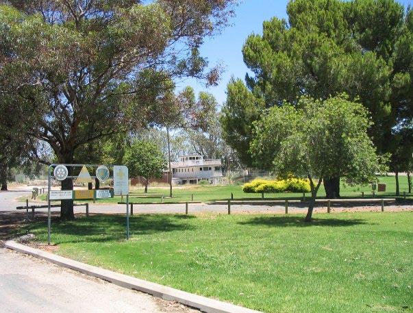
Fotherby Park Reserve 87379
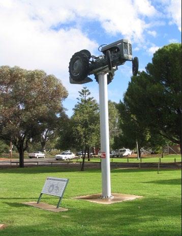
Sportsground, Park and General Community Use management issues have been developed to help define the action plan (found in section 8.4) ensuring that community land is maintained and managed in a sustainable way. These matters are set out below.
The broad category of key issues are:
• Public Access and Multiple Use
• Facility, Buildings, Amenities and Infrastructure – Management, Maintenance and Upgrade
• Landscape Character and Amenity
• Safety and Risk Management
• Vehicle Access and Parking
• Signage and Advertising
• Booking systems Allocation of Space and Use Agreements
• Environmental Sustainability - Management and Cost Efficiency
• Event Management
• Lighting and Fences
• Dogs and Public Land
• Connectivity with other Open Space Reserves and Parks
• Community Gardens, Personal Trainers, and Small Event Bookings
• Economic Benefit
• Community Involvement
• Encroachment on Public Land
• Conservation of Cultural Heritage
• Cemetery Operations
• Interim Use and Development
• Residential and Long-Term Private Home Occupation in Caravan Parks (Crown Reserve and Community Land Constraints)
These broad issues are common/universal to the management of the land whether it is categorised as Park, Sportsground or General Community Use. At a local level, these issues can be pragmatically used in managing the land. However, key words have been used to clarify where an action may apply for each category.
Public Access and Multiple Use
The primary purpose of most of the Reserves as Public Recreation, when coupled with the multi-use and equitable access objectives of the CLM Act, sets the framework for open and accessible use of the land and facilities.
The land in the Plan of Management categorised as Park and Sportsground are solely Crown Reserves with a range of gazetted purposes of which public recreation is the most common. See Appendix A1 for the list of purposes.
Community facilities and associated open spaces and landscapes play an important role for the local community as well as for visitors and tourists to the Wentworth LGA.
These areas offer an opportunity for temporary rest or respite when travelling, opportunities for play with children and animals, as well as contribute to an aesthetic and attractive townscape, while providing variation to the townscape for longer term visitation and stays.
Many of the community facilities, in particular the caravan and camping grounds, the historical buildings and attractions, are important facilities in the town’s economic and tourism development, as well as providing spaces for community use and hire.
Equity of access is fundamental to General Community Facility use for all age groups and levels of ability, particularly to promote independence and social and economic inclusion of people with disability.
Aged, less-mobile and individuals with disabilities, parents with young children or prams, people in wheelchairs or needing ambulatory support all have a right to access and enjoy community facilities and associated open spaces and landscapes . Accessible car parking, paving and level changes, suitable facilities, sightlines, equal access furniture and equipment help to make a park an equally accessible environment for people who may feel constrained in use of community facilities and associated open spaces and landscapes when these accessible and designed facilities are not available.
Barriers to access such as lack of car parking or high steps, guttering, soft or unsteady surfaces should be limited, and design and improvements/developments should incorporate equitable access as a priority.
Facility and Building Management for the entire range of built structures on land is fundamental to the safe operation of the facility, and enjoyable visitor and community use. All the land categorised as General Community Use has facility buildings, structures or infrastructure as part of the land's purpose and use.
There are differing types of management, including direct Council management, leased or licensed management, community groups and organisations, and volunteers. Whilst the facilities and infrastructure are different, there are standard management practices that are applicable, and procedures that ensure quality management of community facilities.
Systemic and formally planned and implemented upgrade and maintenance of active recreation and community facility infrastructure including fields, buildings, aquatic facilities, storage spaces, outdoor playing surfaces, associated amenities and infrastructure, viewing areas, storage spaces and access is important to ensure that the reserve facilities and opportunities continue to meet necessary user standards for current use patterns and to meet future use needs.
Infrastructure maintenance can facilitate increased use of associated and connected public spaces by the local community and visitors to the area, including shared use path linkages, open space furniture, landscape, public art and signage. Buildings and amenities may be provided where consistent with the need to facilitate the recreational use of the land.
Buildings and amenities are to be maintained to the highest possible standard. Where appropriate, public toilets and amenities should be provided and maintained at sites where there are a significant number of users, or a lack of immediate facilities and/or distance from other amenities.
Buildings and amenities will be regularly cleaned and maintained in tidy conditions in accordance with any adopted Council Procedures Manual.
Any areas held under lease, licence or regular occupancy shall be maintained by the regular occupant. Existing assets on the land should be identified and measures taken to maintain them in a satisfactory manner. Council may make arrangements for Community Groups to undertake maintenance for specific facilities on the Council’s behalf.
Sportsground and park vegetation provides a range of benefits from environmental benefits such as wind reduction, water conservation and increased habitat and biodiversity, to community health benefits such as shade and aesthetic landscapes.
The character of open space, landscaping and the associated amenity available in the grounds of sportsgrounds, parks and community facilities, whether from urban or rural landscapes, neighbourhood or regional uses, is an important feature in the community appreciation of the reserves.
The supply and availability of a range of facilities including seating and table, shade, play equipment, paths, signage and amenities buildings such as toilets, provide support and opportunity to further enhance and make safe the parkland and landscapes at sportsgrounds and around community facilities.
Landscape Amenity and Aesthetics
• Shade provision is important at community facilities and associated open spaces in the Wentworth local environment. Shade structures, canopies and awnings, as well as trees, need to be provided and kept in optimal condition to ensure the best possible shade.
• Landscapes need to be varied, usable and accessible to a range of community members and groups. View lines and scenic design can vary from long range and open views to the close and carefully designed and managed smaller areas that create a sense of safety as well as variation.
• Landscaping provides a range of benefits including environmental benefits such as wind reduction, water conservation and increased habitat and biodiversity, as well as community health benefits such as shade and aesthetic landscape benefits.
Furniture and Other Structures
• The supply of outdoor furniture and structures assist safe enjoyment of parks, sportsgrounds and community facilities, and enable a range of activities and opportunities for recreation. Seating, tables, BBQs, shade structures, pathways and bridges, rubbish containers and signage are typically afforded to provide the basis for a range of human age group activity, social family and group interaction.
• Play equipment shall be constructed and regularly maintained in accordance with the relevant Australian Standard and Council’s playground and/or equipment policies and may be replaced or removed as required.
Playgrounds, Fitness Equipment and Skate Parks
Parks, sportsgrounds and certain community facilities land provide an excellent location for many types of play and fitness infrastructure associated with casual and informal recreation, as well as health and fitness, and the development of motor skills at all ages and stages of human development.
Trees and Vegetation and Landscape Protection
• Trees, shrub and flower planting as well as grass or turf in parks and sporting areas provide a respite from the built environment and a chance for the community to relax in a more natural surroundings, while experiencing open-air recreation and leisure.
• Trees provide shade, landscape variation as well as a range of aesthetic benefits in the changing seasons. Planting of shrubs and flower beds can define space or add colour and texture to the landscape, reducing landscape monotony while providing seasonal variation.
Council is responsible for the safety of users and general public for sportsgrounds, parks and community facilities use in the absence of any clear booking, hire or occupancy agreement conditions that transfer certain levels of the safety and risk management responsibilities to the hirer/occupant
Council preparation of a Risk Management and Harm Minimisation Strategy for its sportsgrounds and parks supplemented by an annual audit of sportsgrounds, community facilities, parks and associated amenities for development of a repairs and maintenance schedule, will assist in the management and reduction of risk along with benefits for public and user safety.
Vehicle access and movement, including car parking for regular use and event management is fundamental to safe and effective park, sportsground, community facilities and associated open spaces use.
Provision of dedicated access routes/points and parking arrangements for user and organiser vehicles will assist in the reduction of accidents and provide clear directions for users and community at sportsground, park and community facilities.
Large events using sportsground, park, community facilities and associated open spaces should have traffic management and vehicle parking plans that require Council Officer approval. Liaison with local area police should also occur to ensure basic and adequate tr affic management issues are implemented and to reduce the potential for user/vehicle conflict.
Dedicated parking and thoroughfares or internal access routes will concentrate use impacts and reduce or limit facility or site landscape or asset degradation such as soil compaction, vegetation or asset damage.
Roads and parking areas may be constructed or reconstructed to a safe and all-weather standard.
Signage and Advertising including Town Wayfinder and Site Based Directional
Wayfinder or town directional signage provides for general visitors and district or regional users, as well as playing important roles in providing tourists with information about the availability and location of facilities.
As part of wayfinder signage, place name signs provide the visiting users with destination and place name clarity. Site-specific circulation signage and guidance can enhance visitor and user experience but also make activity an easier experience for personal community members.
Site-based signage provides clear regulatory, as well as user conditions of use, including alcohol free zones, permissible and non-permissible activities, dog leash or leash-free zones, times of specific uses, and internal site or facility directions.
It is important to make the Reserve environment enjoyable for all users and excessively noisy, dangerous or anti-social activities can be regulated and minimised through use of signage and ranger or ordinance officer monitoring.
Interpretive and explanatory signage, whether simple tree genus or species name plates, or heritage or environmental information or education can enhance park use experiences as well as help to provide education or awareness for the community.
Advertising signage at Crown reserves should be ancillary or supportive of the reserve purposes and activities and is not generally acceptable for solely external advertising purposes.
Sportsground fields, courts or areas of parkland booking and allocation of use for temporary, seasonal or annual periods of time is undertaken by Council through its Finance and Policy Department when these arrangements are not subject to existing leases or licences.
Council Policies on use and facility allocation, accompanied by formal advertising of expressions of interest and clear allocation guidelines and criteria will be beneficial for general community and user groups in the reduction of user conflicts and transparency in allocation of community resources and expenditure.
Council Policies on use and facility allocation, accompanied by formal advertising of expressions of interest and clear allocation guidelines and criteria will be beneficial for general community and user groups in the reduction of user conflicts and transparency in allocation of community resources and expenditure.
Use, hiring, and lease or licence agreements are important to ensure that users of community facilities and associated open spaces are aware of, and comply with the conditions and responsibilities of use or occupation.
Council's User Agreements need to be underpinned by use policies and be agreements that set out rights and responsibilities, and matching fees and charges for use, if applicable.
Clear and published conditions of hire and use, including permissible uses, times and user or hirer responsibilities, will provide clarity for users and the community of access and use, user responsibilities and availability of sportsground areas, park facilities or hire of buildings.
Council publishes an annual Schedule of Fees and Charges for a range of goods and services provided by Council and its organisation sections. Inclusion of fees and charges in Council's annually published schedule for Community Facilities and associated open spaces will provide the general community and user groups with clarity and budgetary assurance for short-term, causal hiring as well as seasonal bookings.
Establishing improved levels of base level infrastructure (such as water and electricity) to enable effective use of open space areas and buildings for events, both occasional and regular, will reduce management costs. It will also assist in the allocation of expenditure savings to other areas within the sportsgrounds or make available funds for expenditure elsewhere across Council's open space and community land network.
Operational costs for energy and water use may be reduced through a range of environmental means that warrant Council investigation. Environmental sustainability options and infrastructure, including alternate energy sources, energy and water use efficiency practices and systems, including timing systems or regulated watering practices can be implemented to reduce costs and wastage.
Surface water run-off loss reduction and collection practices not only optimise water application and reduce stormwater loss but can also provide for alternate sources of town or reticulated water supplies during periods of limited availability.
Council and user organisations with occupancy and use agreements, (lessees) should have agreed and sustainable fertiliser and pesticide application and management plans and practices to limit dispersal into less robust environmental systems such as watercourse and water bodies, and to limit human contact from aerial or surface exposure.
The sportsgrounds, larger parks, tennis courts, community facilities and associated open spaces provide opportunities for a range of events and community activities that enrich the community and provide for celebration and festivities. Council is responsible to ensure that events and organised activities are safe for the public and providers/organis ers, as well as avoiding damage to the reserve and its facilities by the users.
Where appropriate, adequate lighting shall be provided on the land to ensure public safety and security for people, buildings and amenities. Night lighting should provide for safe passage through parks or around community facilities without being intrusive on surrounding residential areas.
Fences may be constructed and shall be in accordance with any standards or guidelines adopted by the Council. Normally, as provided for in the Dividing Fences Act 1991, boundary fences are the responsibilities of adjoining owners to construct and maintain, and Council does not contribute to fencing boundaries to private land where adjoining community facilities and associated open space land.
Walking and playing with dogs is a popular recreational activity with physical and mental health benefits. The use of Council footpaths, parks and reserves for casual dog walking and play is generally accepted by the community.
Sportsgrounds have particular use characteristics that warrant restrictions on use of playing fields by dogs, particularly if the sports people come into contact with the surface of the field, e.g: football codes, or the field is used in concentrated fashion such as athletics tracks.
Community facilities are often used by a range of people with particular social, health and community service needs. Whilst companion animals may be required, and the presence of dogs and other animals may be beneficial for many people, walking and playing with dogs at community facilities should be carefully managed.
Parks and sportsgrounds also provide large spaces which are available for a variety of casual recreational uses when not booked by a sporting group or at large park bookings or events. This includes recreational dog use. Recreational dog use includes walking a dog on a leash, and dog off-leash use on some specified areas.
The Companion Animals Act 1998 provides the Framework for Management of Dogs in NSW. The aim of this Act is to provide for effective and responsible care and management of companion animals, and responsible and co-operative management of dogs in public spaces.
Under the Companion Animals Act 1998, and subject to any Council signage, dogs may be walked anywhere on a lead, except within 10 metres of:
• A children’s playground; or
• A food preparation area.
Signage and clear notices about any restrictions Council introduces will assist the community understand and comply with safe and responsible dog and park use.
Improved integration of the network of community facilities, parks with sportsgrounds and nearby land uses of residential and retail, schools, caravan and camping ground will aid visitor use, assist in service delivery and promote higher participation in open space activities.
Community gardens provide the local community with an opportunity to use the land in a cooperative way to produce vegetables, fruit, herbs and flowers while fostering community engagement and interaction.
Gardens can be operated and managed in a number of ways including LG Act S.355 committees, licences or simply availability supported by council, schools or community groups.
Gardens also provide an opportunity for the community to engage in and learn about environmental sustainability and recycling initiatives that benefit the community, including school groups or environmentally interested members of the public.
Personal trainers, fitness groups and small event bookings can be accommodated in parks under licence or hiring arrangements and should be subject to time and area limited with use conditions to limit conflicts of use with the general public.
Tourism and sporting events and activities, either formal or informal and recreation- oriented, have the capacity to make a strong contribution to community and local economies.
The Wentworth Visitor Information Centre in the town of Wentworth, plays an important role in the promotion of environment and heritage of the Shire, as well as the availability of formal and informal sporting and recreational opportunities. This can provide an additional reason for tourists and visitors to use facilities as well as to contribute to the local economy through increased accommodation, food and beverage, goods and services expenditure.
Sportsgrounds and large community events can generate significant noise, traffic, waste management and visitor number issues for local and nearby residents. Night lighting can also cause problems for adjacent residential properties due to glare or lighting spill.
Most environmental impacts on adjacent land uses, such as residential properties or environmentally sensitive areas, can be considered and mitigated as part of development application and approval conditions, and/or implementation of mitigating conditions in user agreements, such as leases or licenses.
Council is empowered by Section 355 of the LG Act to delegate Council functions, including management responsibilities for sportsgrounds and parks, to Council Committees. This Management Committee arrangement is governed by Council Operation provisions in Chapter 12 of the LG Act.
Any encroachments on public land, once identified, should be resolved as quickly as possible to minimise the impact of unlawful use or unauthorised developments on the reserves.
The Old Wentworth Goal, the War Memorial, and the three cemeteries (Coomealla Memorial Gardens, Pooncarie and Gol Gol), the PS Ruby Wentworth Paddleboat, Wentworth Wharf, Coomealla Pioneer Park, The Great Murray Darling Junction Reserve and Wentworth Showground are sites that have specific European cultural heritage values, structures and associated landscapes.
Identified Aboriginal Heritage includes Sturts Billabong, Snaggy Bend Aboriginal Burial Ground, Rufus Creek area and massacre burial site, Willandra Lakes World Heritage Area, Lake Nitchie Area and Fletchers Lake Area.
These sites (where agreed) require specific management that focuses on conservation and interpretation to enable the fabric and history to be conserved and made available for use and visitor experience.
Crown caravan parks and camping grounds are highly valued public land that generally provide for tourist and recreational uses, as well as support the public’s access and use of adjoining or surrounding recreational Crown land.
The operation and management of Crown caravan parks and camping grounds should be considered in context of the larger or surrounding Reserves. However, in rural and regional areas caravan parks also supply valuable and much-needed limited amounts of low-income or short-term residential opportunities.
There are two important roles for Council in the management of Crown Reserves used for caravan parks and/or camping grounds as:
• a Crown Land Manager in accordance with the CLM Act; and
• an Authority that makes an approval to operate a caravan park or camping ground under Section 68 of the LG Act.
There are two Council-approved caravan parks included in the PoM: Willow Bend Caravan Park on R32017 and Buronga Caravan Park on R63988, both of which have a mixture of short-term, long-term and camping sites that include tourist, privately owned dwelling (casual holiday occupation) and a component of residential tenancies on the land.
Crown Reserves used and approved for caravan parks or camping grounds can be generally classified as Community Land under the LG Act and categorised as General Community Use Other community land categories, such as Park or Natural Area(s), should be applied to those areas of the reserve which align with the LG Regulation category assignment guidelines.
The Council Approval to operate a caravan park and/or camping ground requires that the caravan park or camping ground operator must submit and have a ‘Community Map’ approved by Council. The Community Map, in relation to a caravan park or camping ground means a scale map that accurately shows:
• the access roads, community amenities and community buildings within the caravan park or camping ground, and
• the number, size, location and dimensions of dwelling sites or camp sites within the caravan park or camping ground, and
• in relation to a dwelling site or camp site the particular off-site parking space or spaces (if any) designated for use by the occupier of the dwelling site or camp site.
The caravan parks are Crown land reserved for public recreation. The use of public recreation reserves, managed by Council as community land, for residential occupancy and/or long-term occupancy by private vans or mobile homes (private onsite dwellings) is not consistent with the reserve purpose or community land classification.
It is Council’s intention to not increase the numbers of residential tenancies or private onsite dwellings and no additional sites will be occupied by residents, except for emergency disaster relief responses.
The two caravan parks in this PoM have different approvals and arrangements:
Willow Bend Caravan Park on R32017 is Council-operated and under redevelopment planning and construction. It will have a revised LG Act Section 68 Approval and Community Map for its future uses
Prior to redevelopment commencing there were:
• seven sites occupied by long-term residential uses; and
• three sites occupied by private onsite dwelling uses.
These seven residential uses have/had tenancy agreements under the Residential Tenancies Act 2010, and the three private onsite dwelling uses have/had occupancy agreements under the Holiday Parks (Long-term Casual Occupation) Act 2002
Council has stated that it will reduce the seven and three sites by a process of end- of-tenure attrition and convert these to short-term tourist sites.
Buronga Caravan Park on R63988 is leased by Council to a private operator. It has a current LG Act Section 68 Approval and a Community Map.
Currently there are:
• nine of sites occupied by long-term residential uses; and
• no sites occupied by private onsite dwelling uses.
These nine residential uses have tenancy agreements under the Residential Tenancies Act 2010
Council has stated that it will reduce the nine sites by a process of end-of-tenure attrition and convert these to short-term tourist sites
The land managed by Council or lessee will still be managed in accordance with the adopted PoM and the Council S68 LG Act approval requirements and conditions, and the provisions of the Residential Tenancies Act 2010, the Holiday Parks (Long-term Casual Occupation) Act 2002 and associated Regulation.
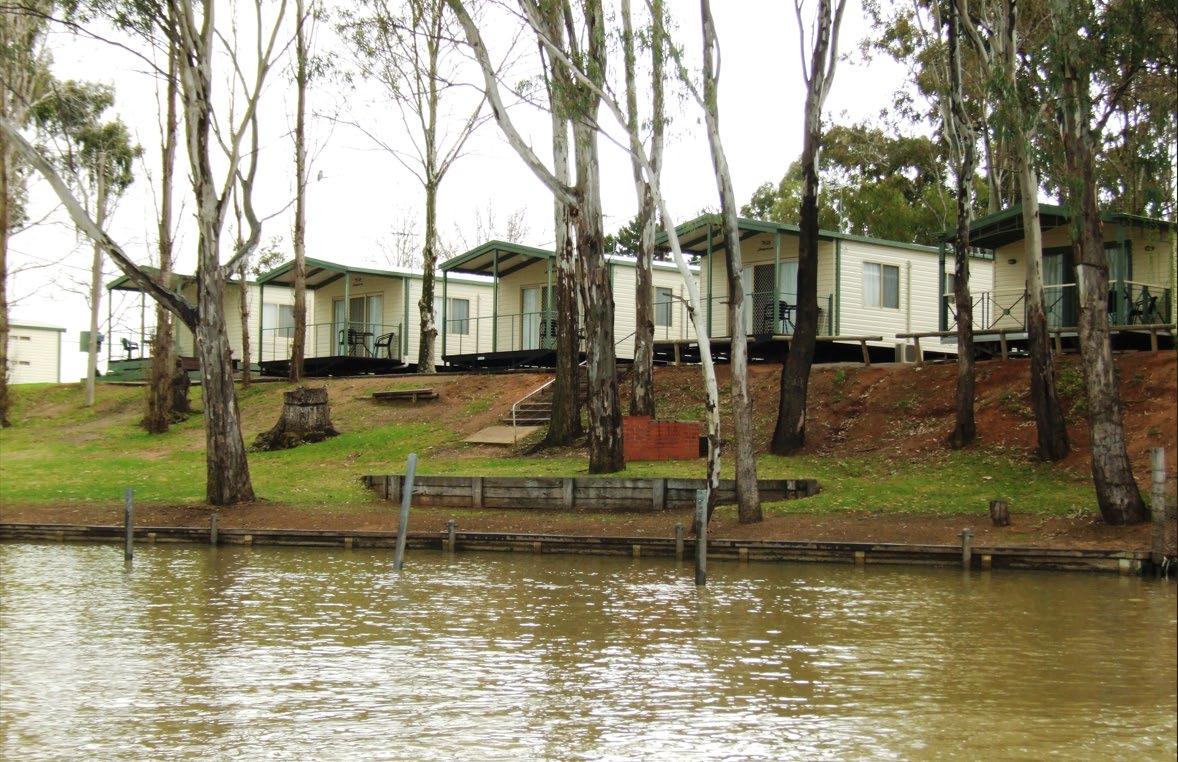
The use and development of community land should be compatible with the legislated purpose of the land and the wider community context.
Council provides and supports a wide range of uses on community land and will continue to facilitate uses which increase the activation of its land and encourage a broad range of activities that are accessible to all.
The use of community land is often supported by appropriate ancillary development such as playground equipment, BBQs, amenity blocks or food kiosks. The general types of uses that may occur on community land and are common to land categorised as Sportsground, Park and General Community Use are set out in Table 11 below.
Separate tables that identify specific uses and developments only permissible to each category are also provided at:
• Sportsground – Table 12;
• Park – Table 13; and
• General Community Use – Table 14.
The facilities on community land may change over time, reflecting the needs of the community. The anticipated uses and associated development identified in the table are intended to provide a general guide. The terminology used is not intended to impose an exact meaning. For example, references such as ‘field’, or ‘court’ are not intended to exclude other sporting surfaces.
Table 11 Consolidated permissible use and development of Community Land that is common to land categorised as Sportsground, Park and General Community Use
Purpose/Use
• Organised and unstructured recreation and cultural activities
• Community events and gatherings
• Active and passive recreation including children’s play and cycling
• Group recreational use, such as picnics and private celebrations
• Eating and drinking in a relaxed setting
• Publicly accessible ancillary areas, such as toilets
• Festivals, parades, markets, fairs and similar
• Concerts, including all musical genres
• Performances (including film and stage)
• Exhibitions
• Events and gatherings
• Workshops
• Leisure or training classes
• Filming and photographic projects
• Busking
• Public address (speeches)
• Development for the purposes of improving access, amenity and the visual character of the reserve and its uses, for example paths, public art, pergolas
• Development for the purposes of active recreation such as play equipment, exercise equipment, bike racks, half-court basketball courts, bocce courts
• Amenities to facilitate the safe use and enjoyment of the reserve, for example picnic tables, BBQs, sheltered seating areas
• Landscaping and finishes, improving access, amenity and the visual character of the reserve
• Café or refreshment areas (kiosks/restaurants) including external seating
• Lighting, seating, toilet facilities, courts, paved areas
• Hard and soft landscaped areas
• Storage sheds
• Car parking and loading areas
• Commercial development that is sympathetic to and supports use in the area, for example hire of recreation equipment
• Ancillary areas (staff rooms, meeting rooms, recording rooms, equipment storage areas)
Purpose/Use
• Toilet/shower facilities
• Shade structures
• Storage ancillary to recreational uses, community events or gatherings, and public meetings
• Locational, directional and regulatory signage
• Heritage and cultural interpretation, e.g. signs
• Equipment sales/hire areas ancillary to the reserve purposes and the approved uses
• Advertising structures and signage (such as A-frames and banners) that:
o relate to approved uses/activities
o are discreet and temporary
o are approved by the council
• Water-saving initiatives such as stormwater harvesting, rain gardens and swales
• Energy-saving initiatives such as solar lights and solar panels
• Bio-banking and carbon sequestration initiatives
Table 12 Permissible use and development of Community Land that is specific to land categorised as Sportsground.
Purpose/Use
• Active and passive recreational and sporting activities compatible with the nature of the particular land and any relevant facilities
• Commercial uses associated with sports facilities
Development to Facilitate Uses
• Development for the purpose of conducting and facilitating organised sport (both amateur and professional), for example:
1. Sports field (cricket, football, track and field athletics, baseball, softball)
2. Marked court (basketball, volleyball, badminton, tennis, hockey, netball etc.)
3. Aquatic facility (learn to swim classes, squad training, fitness and health classes including aqua aerobics, recreational and competitive swimming and diving, organised water sports including water polo, diving, hydrotherapy facilities)
• Professional room s for hire
• Facilities for sports training, e.g. batting cages, tennis walls
• Provision of amenities to facilitate use and enjoyment of the community land including seating, change rooms, toilets, storage, first aid areas
• Meeting rooms/staff areas
• Compatible, small scale commercial uses, e.g. sports tuition
Table 13 Permissible use and development of Community Land that is specific to land categorised as Park
Purpose/Use
• Low-intensity commercial activities (for example recreational equipment hire)
• Community gardening
• Camping is expressly prohibited in reserves categorised as Park, with the exception of those identified for Development to facilitate uses - camping (shown in adjoining column)
Development to Facilitate Uses
• Community gardens
• Camping in designated areas in:
• Reserve 55602 -The Great Murray Darling Junction,
• Reserve 78909 – Thegoa Lagoon, and
• Reserve 97997- Perry Sandhills
Table 14 Permissible use and development of Community Land that is specific to land categorised as General Community Use
Purpose/Use
Providing a location for, and supporting, the gathering of groups for a range of social, cultural or recreational purposes.
Providing multi-purpose buildings (for example, community halls and centres) with specialised community uses such as:
• Casual or informal recreation meetings (including for social, recreational, educational or cultural purposes)
• Functions
• Child care (for example, before and after school care, vacation care)
• Community services purposes (e.g. Community health centres)
• Emergency services purposes (e.g. Rural fire stations)
• Designated group use (e.g. Scout and girl guide use, Men’s Shed, etc)
• Educational centres, including libraries, information and resource centres
• Entertainment facilities
• Active cemeteries
• Caravan parks and camping grounds
Development to Facilitate Uses
Development for the purposes of social, community, cultural and recreational activities, such as libraries, childcare centres, youth services, aged services, men’s sheds, health services, sports.
Development includes:
• Provision of buildings or other amenity areas to facilitate use and enjoyment by the community
• Provision of buildings or ancillary/supportive areas to facilitate delivery of community or emergency services
• Development (particularly within buildings) for the purposes of addressing the needs of a particular group (for example, a stage)
• Development ancillary to the use of a caravan park and camping ground
• Car parking and loading areas
8.4.1
Section 36(3) of the LG Act requires that a PoM for community land details:
(a) The category of the land;
(b) The objectives and performance targets of the plan with respect to the land;
(c) The means by which the Council proposes to achieve the plan’s these objectives and performance targets; and
(d) The manner in which the Council proposes to assess its performance in achieving the plan’s objectives and performance targets.
However, it may require the prior approval of the Council to the carrying out of any specified activity on the land. Table 15 sets out these requirements for community land categorised as Sportsground, Park and General Community Use as an action plan.
The action table has been subdivided into management areas so that the user may discern which action applies to which category of land. In many cases the actions are common or universal to most reserves in the Shire however specific and additional actions have been prepared for certain land uses that have unique characteristics for example, cemeteries.
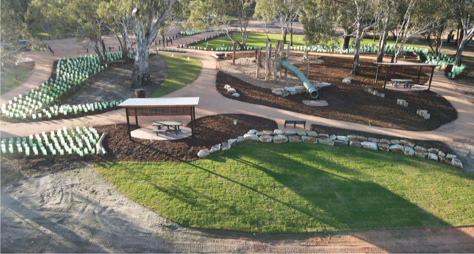
Ensure public access and multiple use
• Compliance of toilets, change rooms and associated amenities infrastructure at sportsgrounds and community facilities for disabled and equitable access uses
• Ensure public accessibility and multiple uses of land in any user occupancy agreements
• Provide for disabled and equitable access at all reserves
• Delineate on-street parking for more efficient use of the street, enable parking close to the facilities
• Undertake analysis of parks, sporting facilities and community facilities to ensure planned upgrades have capacity to service demands of a changing population
• Provide a formalised, centralised booking system for reserves and facilities to facilitate multiple uses and public benefit
• Annual audit of all public use and visitor facilities to evaluate equitable access and maintenance or upgrade needs for compliance with State Legislation and Guidelines
• Include conditions in user agreements/licences that provide for multiple uses and public accessibility where safe to permit
• Identify disability parking spots at each field, park and facility
• Identify high use sportsgrounds and community facilities to clearly mark on-street parking limits and times
• User and visitor conditions of use and activity clearly published and notified to improve safety awareness
• Improve centralised booking system installed for grounds, function centres, halls, meeting rooms etc to facilitate use and enjoyment
• Maintain register and use statistics to ensure capacity of fields, parks and facilities service community needs
• Undertake annual user satisfaction surveys
• Annual amenities equitable access audit and report with response actions prepared
• Publication and use of licence agreements that meet objectives
• Installation of disability parking spots at reserves where most needed
• On-street car parking times, places and conditions signposted and/or marked at high use facilities and reserves e.g James King Park, Wentworth Showgrounds, Sporting Ovals.
• Relevant Council Director to manage program of use and capacity statistics and report on any response actions
• Consider a facilities booking module as an optional extra with the implementation of a new CIS. A decision has yet to be made as to whether this will be included.
Management Issues Objectives and Performance Targets
s.36(3)(b)
Facility, Buildings, Amenities and Infrastructure
Safe maintenance and upgrade of buildings, structures and facilities
Means of Achievement of Objectives
s.36(3)(c)
– Management, Maintenance and Upgrade
• Maintain buildings, field and grounds, parks and community facilities to required standards for users and public safety
• Building and structures compliance with Australian Standards and NSW Building Codes
• Regular repairs, painting and maintenance
• Safe electrical systems
• Safe gas supply
• Sustainable water supply
• Fire systems compliance with NSW Standards
• Safe and operational kitchens
• Safe chemical storage and use
• Implement asset maintenance plans for all major sportsground, park and community facilities buildings, structures and landscape assets
• Annual audit and review of buildings and structures to comply with Australian and NSW Building Codes standards
• System to receive reports/requests for maintenance needs is clearly published and acted upon
• Annual program of (Test & Tag) electrical equipment inspection and testing by a competent person to identify and repair/replace damaged, worn and faulty electrical equipment
• Annual electrical, gas and water supply systems check and review for maintenance and upgrade needs
• Bi-annual fire safety systems check for maintenance or upgrade to meet standards and codes by local Fire brigade or registered authority
• Biannual inspection of all kitchens by health and safety officers to ensure clean, healthy and safe kitchens for users and visitors
Manner of Assessment of Performance
s.36(3)(d)
• User satisfaction surveys conducted
• Asset management plans in place and implemented with annual reports to Council
• Grants Officer to work with the reserve users to coordinate funding for identified needs
• Relevant Council Director responsible for program to review/audit sportsground, parks and community facilities compliance with codes and standards
• Audit and review conducted and reported to Council
• Relevant Council Director approves maintenance system and is accountable for reporting
• Annual Test & Tag inspection results and response actions reported to Council
• Annual electrical, gas and water supply systems check and review for maintenance and upgrading needs
Management Issues Objectives and Performance Targets
s.36(3)(b)
Sportsground maintenance
• Maintain a high level of sportsground and playing surface and associated equipment
Means of Achievement of Objectives
s.36(3)(c)
• All chemical storage, use and handling to be certified by current NSW authority, e.g: WorkSafe NSW
• Whole of site concept plans investigated for high use or important community resources
• Relocate and rebuild the equipment/maintenance shed at the Wentworth Golf Course.
• Improve storage at the Wentworth Town Hall to provide dust free storage space
• Quarterly audit of Council buildings – internal and external
Manner of Assessment of Performance
s.36(3)(d)
• Bi-annual fire safety systems check and response actions reported to Council
• Bi-annual inspection of all kitchens by health and safety officers to and response actions
• Chemical storage, use and handling certification and response actions reported to Council.
• Council considers investigation of whole-site concept/master plan for high use or important community resources e.g Wentworth Showground and racecourse
• Subject to Council resource allocation:
o Move and improve the safety of the equipment maintenance shed at the Wentworth Golf Course
o Investigate provision of dust free storage within the Wentworth Town Hall
Mowing
• Annual or seasonal (as appropriate) user and sportsground hirer or tenure
Management Issues Objectives and Performance Targets
s.36(3)(b)
Amenity Provision • Amenity blocks are available at sites of high or frequent use or sites where no other amenities are nearby
Means of Achievement of Objectives
s.36(3)(c)
• Playing fields and ovals will be mowed in accordance with approvals, manuals or schedules as required.
Line Marking
• Line marking may be undertaken but will normally be the responsibility of users.
Erection of Posts
• The erection of posts on playing fields is allowed by this plan and is the responsibility of Users.
Watering
• Watering of playing fields and ovals shall be undertaken as required and according to specific water restrictions that may be in place.
• Sustainable water supply and management options investigated to minimise long term costs
• During periods of wet weather, the Council may restrict use of playing fields and ovals to prevent damaged to grass surfaces.
Hours of Operation
• Council may restrict the hours of operation of any playing field at its discretion.
• Identify high user and visitor facilities and sites to evaluate amenities provision and supply to meet needs of community and visitor experience
Manner of Assessment of Performance
s.36(3)(d)
holder's satisfaction surveys for:
o Quality of field surfaces or pitches by clubs
o Mowing
o Line marking
o Erection of posts by clubs
o Watering
o Wet weather use and availability
o Hours of operation
• Progressive reduction in water supply and/or management costs as sustainable innovative solutions introduced
• Analysis of user and visitor satisfaction surveys
• Relevant Council Director approves maintenance
Management
Objectives and Performance Targets
s.36(3)(b)
• Amenities provided are kept clean and accessible to users and visitors during daylight hours and at high or frequent visitation sites during facility or site opening hours
• Amenities are maintained for safety, usability and modern standard
Landscape Character and Amenity
Landscape design, grounds and vegetation management
• Provide landscape amenity and environmental benefits at sportsgrounds, parks and community facilities
• Trees and shrubs health maintained, and public risk managed
• Grass and turf maintained to user requirements and standards
• Shade provided at all facilities including playgrounds
• Outdoor fixtures – seats, tables, bins, provided at all sites where outdoors space is associated with facilities
• Play equipment provided at sites where children are substantial numbers of visitors or users
Means of Achievement of Objectives
s.36(3)(c)
Manner of Assessment of Performance
s.36(3)(d)
• Regular inspection and maintenance regime that is clearly published and provides contact details for community and visitor maintenance requests program and is accountable for reporting on outcomes and monitoring of contact queries and complaints
• Retain and maintain existing trees and vegetation in parks and around sportsground for environmental and community benefit
• Prepare landscape masterplans for high use or significant sportsgrounds, parks and community facilities
• Implement vegetation management plans for environmental benefits such as wind reduction, water conservation and increased habitat and biodiversity, community health benefits such as shade and aesthetic landscape benefits
• Regular program of tree and shrub maintenance to ensure healthy and safe vegetation
• Agreed user and community standards for grass and turf maintenance, including limitation of small fire and reduction of
• Council preparation of landscape masterplans for high use or significant sportsgrounds, parks and community facilities
• Council consider report on vegetation management plans, retention and improvement of existing vegetation
• Relevant Council Director approves maintenance program and is accountable for reporting on outcomes
• User and tenure holders consulted in standards for field, grass and turf standards
• Installation of shade structures or increased use of
s.36(3)(b)
Means of Achievement of Objectives
s.36(3)(c)
danger on sites, e.g: noxious plants, feral or dangerous animals
• Review of outdoor spaces associated with facilities and building to evaluate shade needs and provision
• Review of outdoor spaces associated with facility buildings and structures to evaluate and implement outdoor fixture provision
• Review of facilities and sites with substantial numbers of children and teenagers to ensure adequate provision of play equipment and suitable health and leisure fixtures
• Review of cleaning of Play Equipment Roster
Manner of Assessment of Performance
s.36(3)(d)
shade trees to meet shade and sun protection needs
• Fire risk vegetation management in regular maintenance program
• Feral animal, noxious weeds and pest, and dangerous animal reduction programs implemented
• Installation of park and outdoor fixtures, including play, leisure and health equipment is subject to landscape masterplanning for high use sites, or provided consistent with any specific Council policies
• User group and community consultation for provisions of play, leisure and health equipment
• 12 month audit of Play Equipment by contracted auditor
Management Issues Objectives and Performance Targets
Safety and Risk Management
Safety and Risk Management
Means of Achievement of Objectives
s.36(3)(c)
s.36(3)(b)
• Minimise public safety and user risk at sportsgrounds, parks and community facilities
• Risk Management and Harm Minimisation Strategy prepared for sportsgrounds, parks and community facilities
• Annual Safety Audit of all facilities on sportsgrounds conducted by Council in conjunction with formal occupants (lessees, licensees and contracted managem ent)
• Improved lighting for security along pedestrian walkway/lanes – conducted quarterly night audits
• Council to review needs for security around buildings and structures
Roads, vehicle access and parking
• Provide a safe, effective and efficient vehicle and pedestrian environment for community facilities and associated open spaces users and visitors
• Events using community facilities and associated open spaces have safe traffic management and reduce the potential for user/vehicle conflict
• Review of vehicle and traffic infrastructure for entry, internal movement, car parking and vehicle-pedestrian conflict minimisation
• Clear marking of designated access routes and parking arrangements for user and organiser vehicles
• Lessees and licensees have event and traffic management plans incorporated into user agreement conditions as part of agreement
Manner of Assessment of Performance
s.36(3)(d)
• Annual reporting on implementation and risk minimisation
• Annual Council and formal occupant audit of facilities conducted, and response actions reported to Council
• Installation of additional lighting to increase safety along main pedestrian pathways and throughfares
• Council review and report on security needs and options for improvement to relevant facility buildings
• Vehicle and traffic infrastructure review conducted
• Designated traffic, parking and pedestrian lanes marked for areas where events are held and at high attendance facilities
• Event licences and permits to include conditions for event and traffic, user and
Management Issues Objectives and Performance Targets
s.36(3)(b)
• Dedicated parking and thoroughfares or internal access routes to minimise use conflict or site landscape or asset degradation
• Parking areas, speed and vehicle limits clearly signed and marked
Means of Achievement of Objectives
s.36(3)(c)
• Special events have traffic, user and organisation vehicle management plans prepared in liaison with Local Area police
• Regulation of user parking and vehicle at events
• Placement of speed limit signs at prominent locations
• Vehicle type and use restrictions, and parking times clearly signposted where required
Manner of Assessment of Performance
s.36(3)(d)
organisation vehicle management plans prepared in liaison with Local Area Police
• Council resource regulatory officers for traffic and vehicle management at high attendance special events
• Dedicated access routes and parking arrangements for organiser vehicles provided in event agreements
• Speed limits signage installed at sites and facilities where required after review
• Vehicle use and parking time signage installed
Signage and Advertising
Signage and advertising including town wayfinder and site based directional
• Upgrade town signage and wayfinding for general visitors and district or regional users, as well as playing an important role in providing tourists with information about the availability and location of facilities
• Provide clear guidance to sportsground, park and community facility users on reserves conditions of use,
• Prepare and implement a Strategic Town and LGA Wayfinder Signage Program including:
o Town information maps and signage
o Sports grounds, parks and community facilities information, use, permissible activity and regulation signage
• Site-based facility, structure, field and open space regulatory signage to address activity, including:
• Strategy prepared, adopted by Council and implemented as per resources and priorities, including site-based facility, building/structure, field and open space signage, and permissible/non-permissible activity signage.
• Installation of regulatory signage at high use or
Management Issues Objectives and Performance Targets
s.36(3)(b)
including alcohol free zones, permissible and non-permissible activities, dog leash or leash-free zones, times of specific uses, and internal site or facility directions
• Promotional signage for caravan park, halls, and tourist centre and golf course
• On-site directional signs installed to advise of facilities and service locations on site
• Site-based rules and regulations for caravan park, halls, and tourist centre installed in prominent site and facility locations
• Advertising signage at Crown Reserves should be ancillary or supportive of the reserve purposes and activities and is not generally acceptable for solely external advertising purposes
Booking systems, fees and charges and conditions of hire
• Council review and formalisation of integrated booking systems for casual and seasonal use agreements.
• Public awareness notices or policies of booking and hiring systems are clearly available
Means of Achievement of Objectives
s.36(3)(c)
o Alcohol-free zones,
o Permissible and non-permissible activities,
o Dog leash or leash-free zones,
o Times of specific uses
• Evaluate any signage proposals for Crown reserves to ensure advertising is ancillary to reserve use and management
• Improve signage in Fotherby Park in particular to identify the hydraulic bridge jack
Manner of Assessment of Performance
s.36(3)(d)
visitation sports grounds, parks and community facilities
• Subject to available resources erect identification signage for the hydraulic bridge jack at Fotherby Park
• Council development and implementation of policies on use and facility allocation, accompanied by formal advertising of expressions of interest and clear allocation guidelines and criteria
• Council adoption and publication of grounds and facility allocation policy and procedures
• Seasonal and annual EOI processes conducted to
Management Issues Objectives and Performance Targets
s.36(3)(b)
• Clear and accountable fees and charges for sportsground use and hire
• Conditions of use and hire are clearly published and supplied with booking and hire details
• Standard user agreement documents, e.g: leases, licences and short-term use permits
Means of Achievement of Objectives
s.36(3)(c)
• Formal EOI and user agreement allocations to be conducted at annual or seasonal, as well as event -based periods
• All bookings or hiring receive e-copy or paper copy of confirmation including any conditions of use and hire with contact details to assist hirer or user
• Publication of booking and hiring notices and polices, fees and charges on Council website, local media as required and at sites where warranted
• Council develop lease, licence and casual hiring, short-term and temporary licence agreements based on Crown Lands templates
• Clear and published conditions of hire and use, including permissible uses, times and user or hirer responsibilities
Manner of Assessment of Performance
s.36(3)(d)
inform allocation procedures and hire or use agreements
• Council website publication
• Production and use of conditions of use and hire with contact details to assist hirer or user with all bookings or hiring Standardised user agreements in use
• Council publication of conditions of hire and use, including permissible uses, times and user or hirer responsibilities on use agreements, and casual hire permits.
Use Agreements
• Council policies on use and facility allocation are accompanied by formal advertising of expressions of interest and clear allocation guidelines and criteria
• Standard user agreement documents, e.g: leases, licences and short term use permits
• Council develop lease, licence and casual hiring, short-term and temporary licence agreements based on Crown Lands templates
• Clear and published conditions of hire and use, including permissible uses, times and user or hirer responsibilities
• Council publication of conditions of hire and use, including permissible uses, times and user or hirer responsibilities on use agreements, and casual hire permits
• New centralised, integrated booking system installed.
•
Management Issues Objectives and Performance Targets
s.36(3)(b)
Environmental Sustainability - Management and Cost Efficiency
Environmental Management and sustainability
• Council investigation of environmental sustainability options and infrastructure, at sportsgrounds, parks and community facilities
• Reduction in operational costs for energy and water use through a range of environmental and sustainable means to reduce costs and wastage
• Surface water run-off loss reduction and collection practices to optimise water use and reduce stormwater loss to minimise use of town or reticulated water supplies during periods of limited availability
• limit dispersal of sustainable fertiliser and pesticide into less robust environmental systems such as watercourse and water bodies, and limit human contact from aerial or surface exposure
• Development and maintenance is undertaken with environmentally sustainable practices and within Australian or NSW standards
• All hazardous materials and chemicals are handled, stored
Means of Achievement of Objectives
s.36(3)(c)
• Investigate implementation of alternate energy sources such as solar electricity and heating systems at facilities on sites
• Energy and water use efficiency practices and systems, including timing systems or regulated watering practices.
o Council investigation of investment into water efficiency actions
o Safe re-use of effluent and grey waters
o Water harvesting from storm and ground water through collection for use at sports grounds
o On site dams where suitable, e.g: golf course
• Council and user organisations with occupancy and use agreements for sustainable fertiliser and pesticide application and management plans and practices
• All chemical storage, use and handling to be certified by current NSW authority, e.g: WorkSafe NSW and initiatives to replace or reduce use investigated
Manner of Assessment of Performance
s.36(3)(d)
• Council investigate and consider options for costefficiency and sustainability of:
o Sources such as solar electricity and heating systems at facilities on sites
o Energy and water use efficiency practices and systems, including timing systems or regulated watering practices
o Investment into water efficiency actions
o Safe re-use of effluent and grey waters
o Water harvesting from storm and ground water through collection for use at sportsgrounds
o On site dams where suitable, e.g: golf course
• Council publication and use of user agreements that include conditions for sustainable fertiliser and pesticide
Management Issues Objectives and Performance Targets
s.36(3)(b)
Means of Achievement of Objectives
s.36(3)(c)
Cost efficiency in utilities and infrastructure
Environmental sustainability
Manner of Assessment of Performance
s.36(3)(d) and used in accordance with NSW legislation application and management plans and practices
• Chemical storage, use and handling certification and response actions reported to Council.
Feral animals, pests and noxious weeds
• Reduce costs to Council, users and hirers/tenants at sportsgrounds, parks and community facilities
• Use of chemicals and fertilisers is limited and sustainable
• Groundwater run-off is contained and recycled where possible, or directed to storage
• Conditions of use and development clearly outlined in occupancy agreements
• Removal of pests and noxious weeds is undertaken and pest and feral animals captured, removed or reduced in compliance with legislation and council policies
• Conditions for management and reduction of feral animals, pest animals and noxious weeds
• Review of water and energy use at facilities
• Investigation of alternate and cost-effective energy and water systems
• Investigate timed or smart lighting.
• User/occupants to provide annual report on chemical and fertiliser use
• Occupancy agreements detail environmentally sustainable conditions including groundwater management plan
• Review and investigations conducted, and response actions reported to Council
• Annual reports provided to relevant Council Director
• Occupancy agreements contained required conditions
• User/occupants to provide annual report on pests, noxious weeds and feral animal management
• Occupancy agreements detail pest animals, noxious weeds and feral animal management conditions
• Annual reports provided to relevant Council Director
• Occupancy agreements contain required conditions
Management Issues Objectives and Performance Targets
s.36(3)(b)
Means of Achievement of Objectives
s.36(3)(c)
Event Management
Event Management
Manner of Assessment of Performance
s.36(3)(d) included in occupancy agreements
• Ensure all events have event management licenses or permits through bookings or hiring.
• Include event management plans, traffic management plans, waste and public safety plans in licence conditions.
• Establish clear and published booking and hire system for events
• Prepare and use event licences or permits with inclusion of event management plans, traffic management plans, waste and public safety plans
• Publication and use of licences with conditions that address objectives
• Council website publication of booking and hire systems including seasonal dates and conditions of application
• Council is resourced to have a staff member/s able to manage hire queries
Lighting and Fences
Lighting
• Lighting is provided for visitor and user safety at all buildings and on structures where night/dark use is present
• Lighting impact on neighbours and other users not requiring lighting is minimised
• Lighting is supplied at all car parks where night/dark use is present
• Lighting is provided for user and visitor throughfare travel at sites of frequent use
• Review of facilities and structures to evaluate lighting needs and gaps for safety and to meet users and visitor needs
• Ensure lighting spill and brightness complies with current and acceptable industry standards
• Review provision of safe lighting at night/dark use carparks and user or visitor throughfares and install lighting to meet needs or gaps in provision
• Lighting for evening and night grounds uses conform to Australian and industry/sports standards
• Lighting needs review and implementation program prepared and adopted by Council
• All lighting approved by development application to meet identified standards
• Night/dark safe lighting needs review conducted, incorporating CEPTED principles and provision priorities reported to Council
Management Issues Objectives and Performance Targets
s.36(3)(b)
• Reduce the impact of night lighting on adjacent residential properties due to glare or lighting spill.
• Review sportsground, park and community facility lighting to ensure lighting spill impacts are limited on adjacent properties and businesses
Fences
• Clear demarcation of public spaces and community facility boundaries with fences constructed in accordance with any standards or guidelines adopted by the Council
Dogs on sportsgrounds, parks and community facility open space
• Ensure dog use on parks, reserves, and sportsgrounds complies with State legislation.
• Manage dog walking and play on and around sportsground playgrounds, food preparation areas, footpaths, parks and reserves.
• Reduce impacts of dog use on fields and parks
Means of Achievement of Objectives
s.36(3)(c)
• Include lighting in development approval conditions and event or user agreements.
Manner of Assessment of Performance
s.36(3)(d)
• Relevant Council Director to manage review and report to Council on any response outcomes
• Council Planning directorate to integrate public lighting into development application approval conditions
• Negotiate with adjacent landowners to erect and maintain suitable and safe fencing
• Fencing installed at agreed or required dimensions
• Install signage including restricted areas, particularly on playing fields, but with an emphasis on no dogs within 10 metres of:
o A children's playground; or
o A food preparation area.
• Provide at least one leash-free dog area in the LGA
• Publish animal and dog handling guidelines on Council website
• Signage installed
• One leash-free dog play area in LGA created and managed
• Dog faeces bins provided at high use areas –sportsgrounds, parks, community facilities and any identified or promoted walking tracks and trails
• Council website publication of Companion Animal and Dog
Management Issues Objectives and Performance Targets
s.36(3)(b)
Means of Achievement of Objectives
s.36(3)(c)
Manner of Assessment of Performance
s.36(3)(d)
Handling Rules and Regulations
Connectivity
Connectivity with other open space reserves and parks
• Improved access movement between reserves and community facilities
• Provide pathways and signage between sportsgrounds, parks and community facilities and town centre, nearby schools and council facilities
• Pathway development and maintenance program approved and implemented by Council
• Provide improve pathways and all weather covering between adjacent facilities at sportsgrounds, parks and community facilities
• Pathway development and maintenance program approved and implemented by Council
Community Gardens
Personal trainers, and small event bookings
• Provide opportunities for interested parties to establish and maintain community gardens at suitable locations
• Work with community groups and organisations, schools and incorporated bodies to determine interest in community garden establishment and maintenance
• Personal trainers, fitness groups and small event bookings are safely conducted with minimal impacts on other reserve users and adjacent residences.
• Personal trainers, fitness groups and small event bookings are accommodated in the park under licence or hiring arrangements, subject to time and area limited with use
• Establishment of community gardens managed by community groups and organisations, schools and incorporated bodies
• Licence system and documents prepared and used for personal trainers, fitness groups and small event bookings.
Management
s.36(3)(b)
and Performance
Means of Achievement of Objectives
s.36(3)(c)
conditions to enable use to limit conflicts of use with the general public.
Contribution to tourism and local economy
• Council coordination of sportsgrounds and event management with tourism and economic development officers in Council and community
• Improved integration of parks, sportsgrounds and community facilities with town and village commercial and retail areas to attract and retain visitors to the area
• Promote sporting facilities and availability of formal and informal sporting opportunities for tourists and visitors
• Council proactively supports the financial sustainability of its reserves which contribute to the local economy, and social and community well being
• Invest in public WIFI to attract and retain visitors and workers to the area
• Development of Sports and Recreation Economic Tourism Plan or Strategy
• Undertake concept or masterplans to link and connect commercial core areas with parks and reserves to provide improve relationship between public and commercial spaces
• Develop Shire-wide promotional strategies that focus on the leisure and tourism industry with use of sports fields, parks, golf course and community facilities, e.g: camping and caravan grounds to use not only the facilities but also contribute to the local economy through increased accommodation, food and beverage, goods and services expenditure.
• Reduction in running costs and ability to recoup investment through lease, license and user agreements
• Investigate ways to generate revenue to enable the reserves to be self-sustaining
• Investigate the viability of providing public WIFI in high use areas
Manner of Assessment of Performance
s.36(3)(d)
• Sports and Recreation Tourism Strategy considered by Council and developed and adopted by Council
• Council consideration of concept plan or masterplan for public space integration with commercial and retail areas
• Wentworth Shire Council promotional strategies for leisure and tourism considered, developed and adopted by Council
• An income stream is identified for relevant reserves
• Council considers and implements longer term lease or license agreements to facilitate long term planning and investment e.g
• Options for provision of public WIFI considered and actioned by Council
Management
Community Involvement
Community involvement/neighbour relations
Objectives and Performance Targets
s.36(3)(b)
• Manage event and activity noise, traffic, waste management and visitor number issues for local and nearby residents
• User agreements include conditions to limit impacts from noise, rubbish, traffic
Means of Achievement of Objectives
s.36(3)(c)
• Prepare and implement user agreements (licences or permit) system
Manner of Assessment of Performance
s.36(3)(d)
• Licences published and used with conditions to limit or reduce impacts from noise, rubbish, traffic
Operating committees and incorporated bodies
• Increase user and community involvement in sportsground, park and community facility management and maintenance
• Establish a Reserve User Group where there are multiple users at a reserve Council.
Contract and Volunteer Labour
Encroachment on Public Land
• Safe, legal and formal contractor and volunteer involvement in management, use and maintenance of community facilities and associated open spaces
• Review of existing contract agreements and permits or licences for volunteer groups, organisations and any individuals
• Preparation and use of legal contracts and agreements, licences and permits
• Half yearly meeting conducted with representatives from each group (Office bearer and member) with WSC representative and a Councillor
• Review conducted, gaps and needs established
• Agreements, contract, licences and permits in use
• Encroachments on public land, once identified are resolved as quickly as possible to minimise the impact of unlawful use or
• Council rectification of encroachments or illegal developments on all Council-owned and managed open and public spaces
• Licence agreements can be issued for some encroachments on Crown land
• Identified encroachments rectified
Management Issues Objectives and Performance Targets
s.36(3)(b)
unauthorised developments on the reserves.
Conservation of Aboriginal and European Heritage
• Important Aboriginal and European Cultural Heritage is conserved for future generations
• Cultural Heritage information and education are readily available for community, visitors and tourists
Means of Achievement of Objectives
s.36(3)(c)
Cemetery Operations
Cemetery operation
• Cemeteries are operated and maintained to provide cultural, respectful and accessible interment for community
• Ensure Local, State and National heritage items have required or suitable planning instrument protection and listings
• Review of heritage items, sites and areas for conservation needs, planning and management
• Aboriginal Heritage Information Management System (AHIMS) Searches are conducted prior to any Council development
• Follow the Due Diligence Code of Practice for the protection of Aboriginal Objects in NSW
• Consult with the Aboriginal Comm unity to determine the presence of any aboriginal sites, places or objects
• Review heritage items, sites and areas for education, information and interpretive schemes
Manner of Assessment of Performance
s.36(3)(d)
• Heritage Register listings are updated and maintained
• Local Environment Plan updated for new or revised heritage listings as relevant
• Aboriginal sites or historical sites identified and protected
• Im plementation of heritage site, items and area interpretation plans and schemes
• Cemeteries are operated by Council as a cemetery operators under the Cemetery and Crematoria Act 2013
• Council cemetery and crematoria operations are undertaken consistent with any guidelines, circulars, protocols and customer
• Cemetery operation is legal, safe and interment is provided in a respectful, affordable and sustainable manner
s.36(3)(b)
Means of Achievement of Objectives
s.36(3)(c)
standards prepared by Cemeteries and Crematoria NSW CCANSW
• Council provides relevant data and information as requested by Cemeteries and Crematoria NSW
Manner of Assessment of Performance
s.36(3)(d)
• Cemetery operation and interment costs are included in the Council's Annual Fees and Charges publication
• Annual report to Council on operations and compliance with the Cemetery and Crematoria Act 2013, and any guidelines, circulars, protocols and customer standards prepared and issued by Cemeteries and Crematoria NSW
Interim uses
Development and uses
• Occupancy agreements are implemented at each location only for agistment or low-impact agricultural uses and without any permanent structures
• Enclosure/fencing is the responsibility of occupants
• Interim uses and purposes are used as conditions in occupancy agreements
• Limited to low impact uses with no fixtures or structures unless approved through adopted Plan of Management and Council Approval
• Occupancy agreements include condition that only provide for:
o Agistment or low-impact agricultural uses and limits on permanent structures; and
o Occupant responsibility for adequate and suitable fencing of properties
• Occupancy agreements contained required conditions
• Council approval and adopted Plan of Management permission for developments and uses (other than low impact uses without permanent structures)
• Permission provided by this Plan of Management and Council Approval
Management Issues Objectives and Performance Targets
s.36(3)(b)
Residential and long-term private home occupation in caravan parks
Management of residential tenancies and long-term private homes in Willow Bend and Buronga Caravan Parks
• Caravan park use is consistent with the CLM Act and the LG Act
Means of Achievement of Objectives
s.36(3)(c)
• Residential tenancies and longterm private homes in caravan parks is limited by Council adopted socio-economic policy
• Council S68 LG Act approval identifies limited residential tenancies and long-term private homes
• Land areas occupied by residential tenancies and long-term private homes are managed in accordance with the adopted PoM or with the Minister's consent/approvals
• No increase to existing approved numbers of residential tenancies or long-term dwellings
• Council policy development to set criteria for residential tenancies or long-term occupations in caravan parks
• Council phase out occupation except for sites that meet criteria for occupation
Manner of Assessment of Performance
s.36(3)(d)
• Legal occupation of caravan park sites by residential tenancies and long-term private homes
• No increase in residential tenancies or long-term private homes
• Tenancies meet socioeconomic policy criteria
• Phase out of sites not used in accordance with policy criteria
Data source: Wentworth Shire Council and Crown Land NSW portal May 2022
Note: Reserve numbers run sequentially.
63988
Community Use Park
AreaBushland
Community Use Park
pavilions and change rooms. Parish Mourquong County Wentworth
Area –Bushland Commercial Caravan Park / with long term lease arrangements in place
Whole: Lot 1159 DP 725383, Lot 980 DP 756961, Lots 2-4 DP 1032974, Lot 101 DP 1232718, Parish Mourquong County
Wentworth
64544 Part Buronga Caravan Park
11/05/1934 Public Recreation Access Natural AreaBushland Natural AreaBushland Vacant scrub land adjacent to Caravan Park Reserve.
Lots 429-431 DP 756961 Parish Mourquong County
Bitumised area for basketball casual users Lot 701 DP 1126803 Parish Mourquong County
73351)
72718 Pooncarie Oval
4/06/1948
Recreation Sportsground Park Sportsground Park Cricket club disbandedcommunity oval with no regular users. Lot 1430 DP 763147, Lot 7302 DP 1182431 Parish Pooncaira County Perry Pooncarie RE1 Public Recreation
96592 Tuckers Creek Reserve
97997 Perry Sandhills
11/02/1983 Flood Mitigation Public Recreation Park Park Riverfront parkeasement over Lot 30 for Town Levee
22/11/1985 Public Recreation Park
Natural AreaBushland Natural AreaWatercourse Park, Natural AreaBushland, Natural AreaWatercourse Natural inland sandhills and riverfront scrub
Lot 30 DP 45055, Lot 7340 DP 1176401 Parish Wentworth County
Wentworth
Lots 3-4 DP 610639, Lot 5204 DP 725295, Lots 16, 51, 58-60, 6364, 7009-7012 DP 756964, Lot 7309 DP 1183405 Parish Neilpo County Wentworth, Lot 5201 DP 725295 Parish Wentworth County
Wentworth
Community Use, Sportsground (directed)
Community Use, Sportsground Community building - tennis courts - ovaltree plantationdam - golf course –Licence user group
Lot 5132 DP 720112 Parish Palinyewah County
7/03/1986 Public Recreation Park Park Park / Children’s Playground Lot 399 DP 761064, Lots 7307-7309 DP 1180919 Parish
Pooncaira County
Perry Note: Lot 7307 DP 1180919 also part of R77413
Nil FREEHOLD - WSC Car Park Midway Centre General Community Use Car Park for Midway Centre
Nil FREEHOLD - WSC Midway Centre
Nil FREEHOLD - WSC Second Oval - land being Lot 2, DP 1239025, adjacent to George Gordon OvalReserve 61503
General Community Use Community Centre - areas for hire - library - basketball courts –multiple licenced users
General Community Use Sporting Oval – User Group in place - multiple permanent users
Nil FREEHOLD - WSC Civic Centre General Community Use Being developed as Council Offices
Nil FREEHOLD - WSC Wilkinson Hall
1239025
General Community Use Leased to community group (Mildura Vintage Vehicle Club Inc)
Nil FREEHOLD - WSC Little Manly General Community Use Public recreation, area suitable for camping, fishing, picnicking, etc
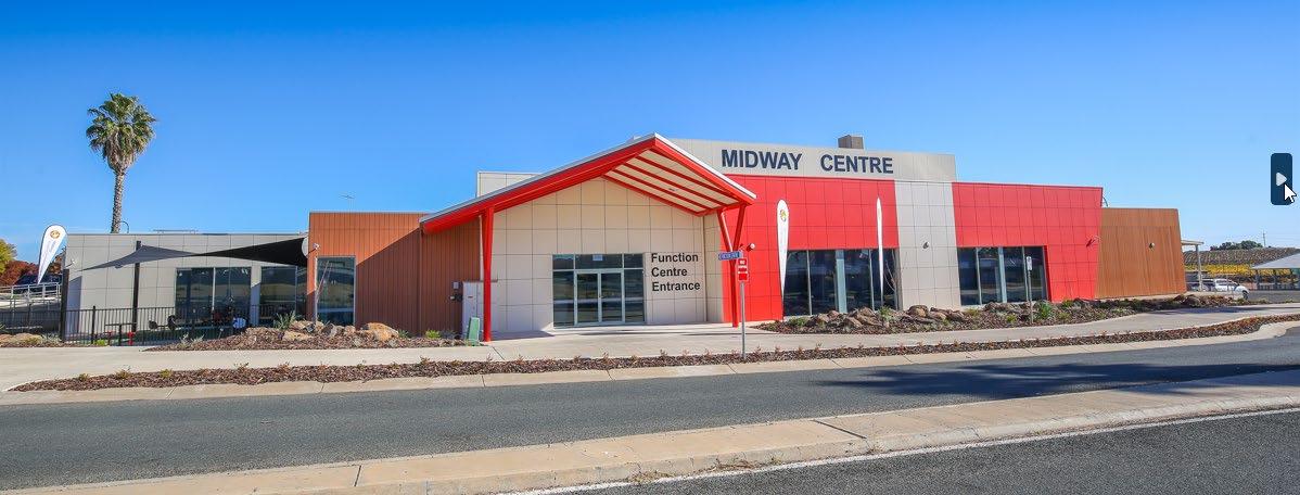
Data source: Wentworth Shire Council – for a list of occupant activities and agreement purposes please contact Council.
61503 George Gordon Oval
63988 Buronga Caravan Park Reserve (Wentworth Rowing Club)
67891 630001 73351 75014
73211 & 630011
Wentworth Showgrounds
Curlwaa Oval
77930 Wentworth District Rowing Club
78698 & 83919
81398 & 83919
Wentworth Sporting Complex Reserve Trust (McLeod Oval)
Wentworth Sporting Complex Reserve Trust (McLeod Oval)
83919 Wentworth Sporting Complex Reserve Trust (McLeod Oval)
84989 Anabranch Hall and Tennis Courts
Pooncarie Gun Club Inc
Pooncarie Racing Club Inc
Sunraysia Motorsports Club Inc.
Pooncarie Field Days Group
Coomealla Wentworth Cricket Club
Wentworth District Football Netball Club
Wentworth District Rowing Club Incorporated
Coomealla Mildura Mountainless Bike Club
The Dareton Kennel Club Inc.
Wentworth Show Society Inc
The Vintage Machinery Society of Sunraysia
Inc Wentworth District Racing Club Inc.
Australian Mounted Games Association Inc.
Mildura Wentworth Music Festival
Curlwaa Islanders Cricket Club
The Delta Scout Group
The Coomealla Wentworth Cricket Club Inc.
Wentworth District Rowing Club Incorporated
Wentworth Sporting Complex Golf Club
Coomealla Wentworth Cricket Club
Wentworth Bowling Club Inc
Wentworth Tennis Club
Lower Anabranch Sporting and Landcare Group Inc
Various short term licences for camping
85020 Pitman Avenue Recreation Reserve Buronga HealthOne
85636 Dareton Pre School
89255 Buronga Community Arts
Dareton Youth & Children’s Outreach
Coomealla Health Aboriginal Corporation (CHAC)
Electric Light Theatre Inc.
89637 Gol Gol Kindergarten Reserve Trust Gol Gol Preschool
89749 Wentworth Junction Park
89864 Dareton Community Activity Centre
Murray Darling Junction Fishing Club
Dareton Community Creative Centre Inc
91386 The Alcheringa Oval Reserve Trust/ Carramar Drive Sporting Complex
98030
150038
Ellerslie Sporting Complex Reserve
Coomealla Pioneer Park
230030 Wentworth Preschool
230081
230096
Pooncarie Multipurpose Park and Golf Course
Pooncarie Outback and Beyond Craft Gallery and Museum
630036 Wentworth War Memorial Rooms
1036648
Wentworth Community & Council Facilities Reserve Trust (Wentworth Town Hall)
97997 Perry Sandhills Reserve
Long term licences
73620 James King Park
Gol Gol Cricket Club Inc.
Gol Gol Hawks Football Netball Club Inc.
Buronga Gol Gol & Districts Lions Club
Ellerslie Community Hub
Coomealla Senior Citizens Club
Wentworth District Pre-school & Play Centre
Pooncarie Golf Club Incorporated
Pooncarie and District Development Association Incorporated (PADDA)
Pooncarie & District Development Association
Pooncarie Mail Exchange
Rotary Wentworth Op Shop
Darling Junction CWA
Wentworth District RSL Sub Branch
Wentworth RSL Auxiliary
Buronga HealthOne
Wentworth District Community Medical Centre
Wentworth Senior Citizens Club
New South Western Standard Bulletin
Wentworth Regional Community Project Association Inc.
Various short term licences for filming
Alcheringa Tennis Club
78438 Dareton Horse Complex Ramon Deed Veterans Retreat 85836 Dareton Swimming Pool Men in a Shed Contracts/Service Agreements
1010468 Gol Gol Fire Station
630005 Pomona Public Hall
73211 Curlwaa Oval
Commissioner of the NSW Rural Fire Services
Commissioner of the NSW Rural Fire Services
Commissioner of the NSW Rural Fire Services
85836 Dareton Swimming Pool WSC contract to Belgravia 81398 Wentworth Swimming Pool McLeod Oval WSC contract to Belgravia Leases
88251 Coomealla Golf Course
85572 Old Wentworth Gaol Reserve
63988 Buronga Caravan Park
32017 Willow Bend Caravan Park
63988 Buronga Caravan Park -part
1003148 Coomealla Memorial Gardens Crematorium
Wilkinson Hall
Coomealla Memorial Golf Club
Old Wentworth Gaol Reserve
Buronga Bridge Mooring Pty Ltd
WSC - Willow Bend Caravan Park
Discovery Parks Holdings Pty Ltd
Mildura Funeral Services Pty Ltd
Mildura Vintage Vehicle Club Inc.
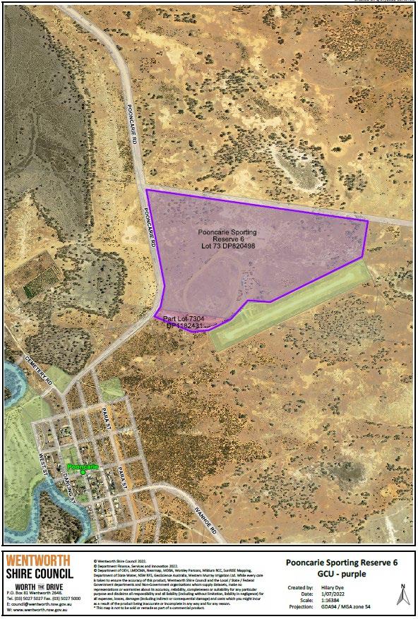
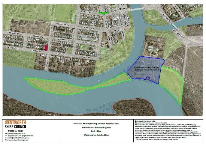
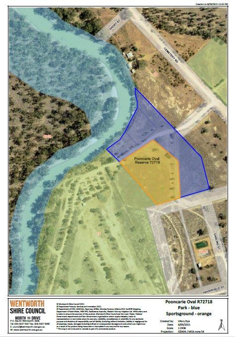
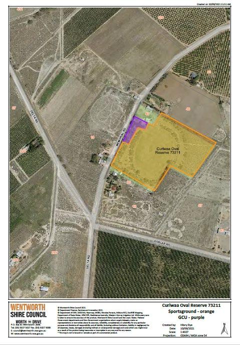
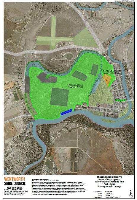
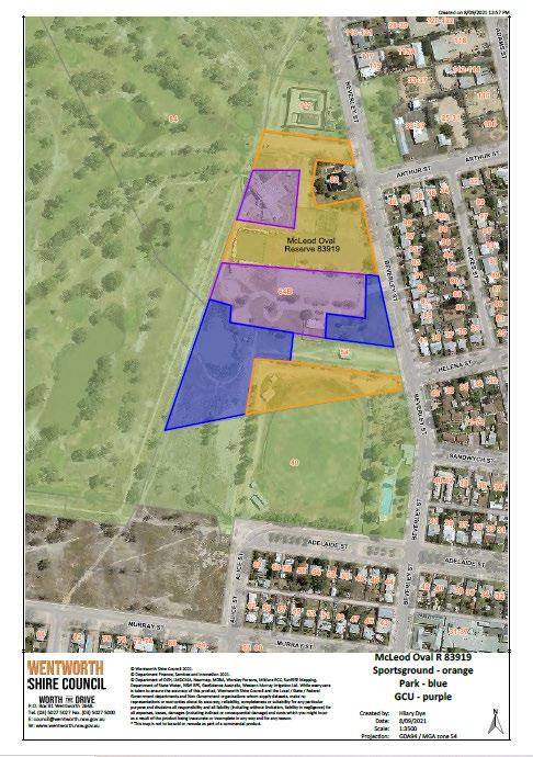
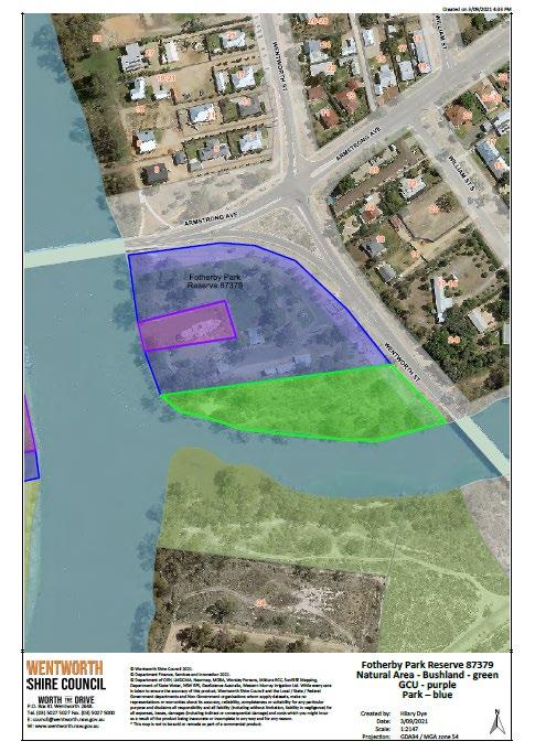
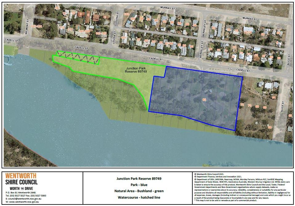
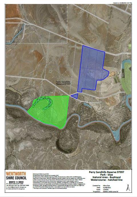
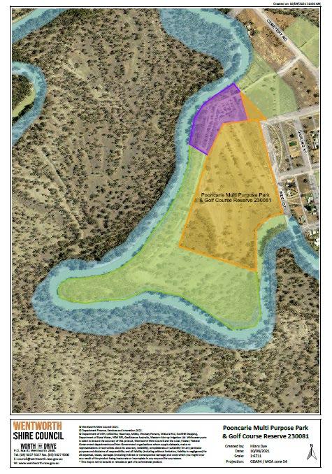
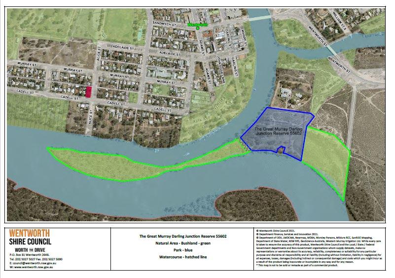
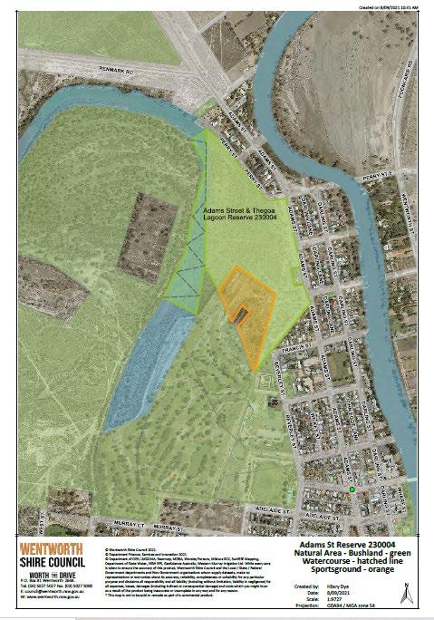
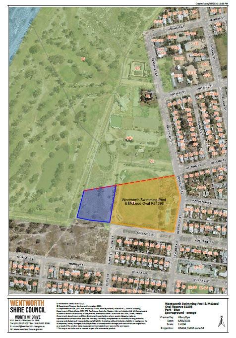
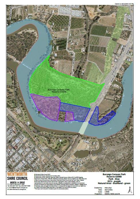

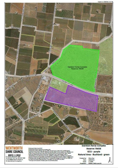
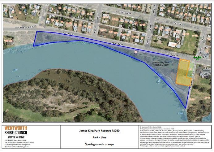
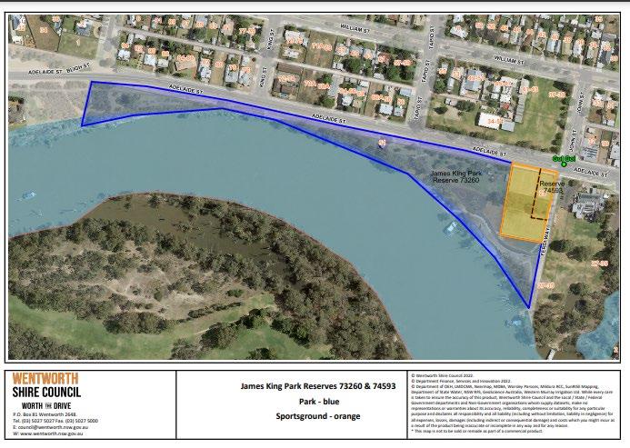
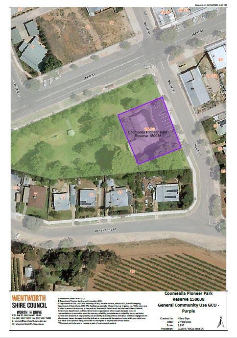
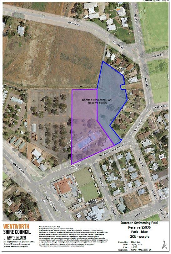
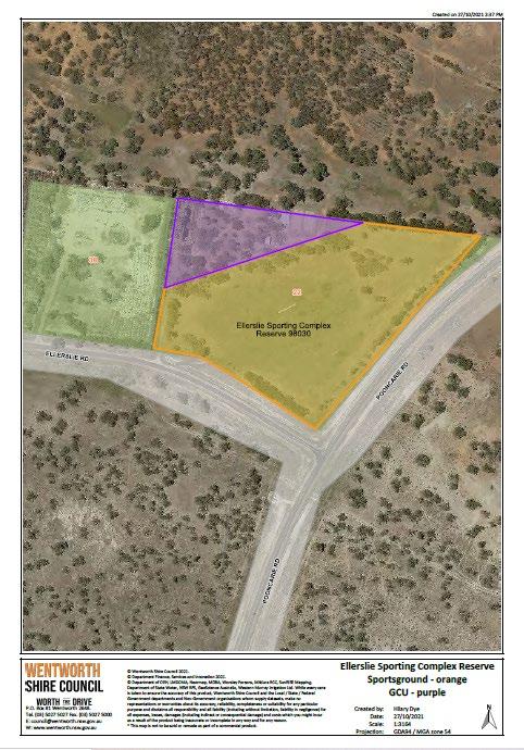
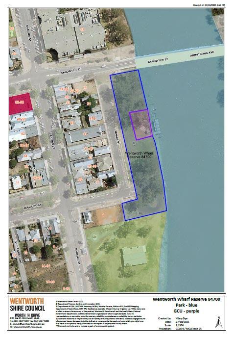
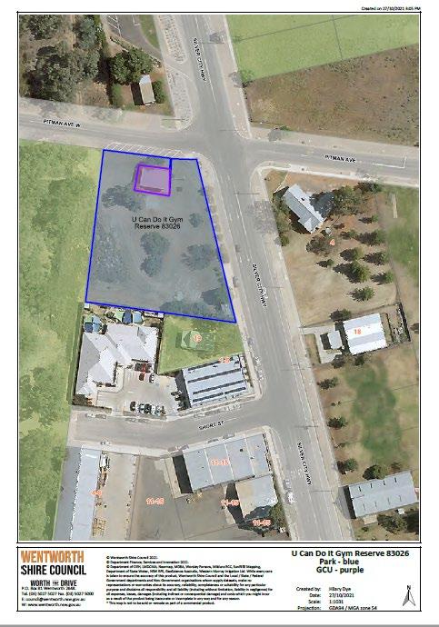
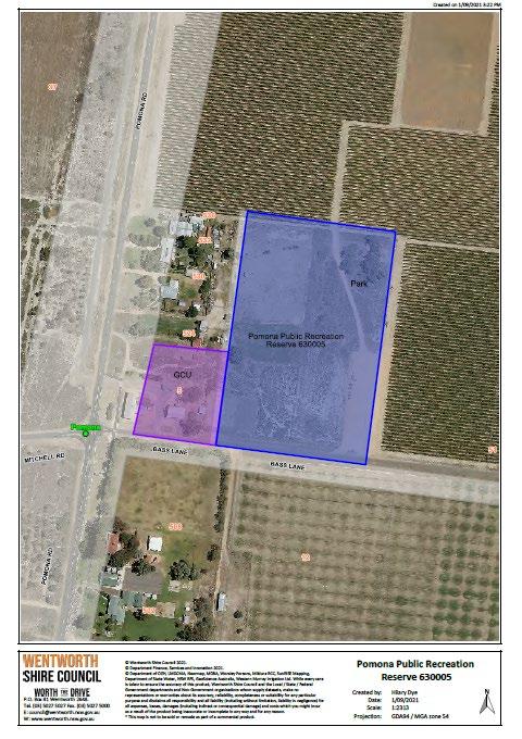
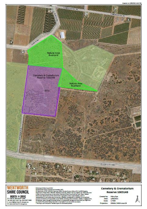
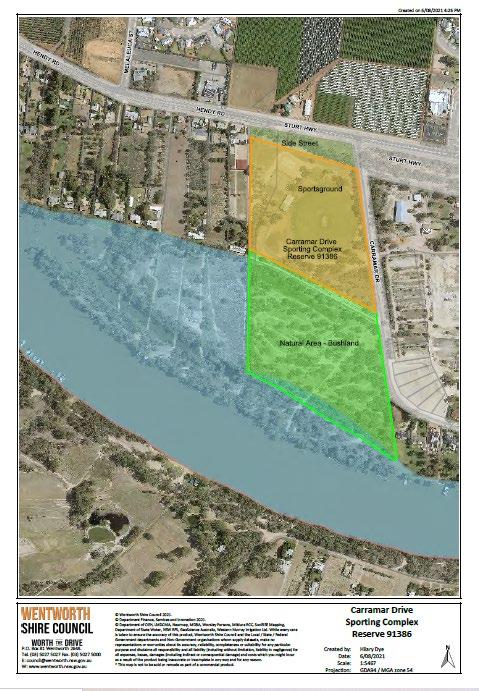
The Environmental Planning and Assessment Act 1979 (EP&A Act) provides the framework for planning and development across NSW and guides environmental planning instruments which provide a basis for development control.
The EP&A Act ensures that effects on the natural environment, along with social and economic factors, are considered by the council when granting approval for or undertaking works, developments or activities.
This Act is also the enabling legislation for planning policies which may have a direct influence on open space management. On a state-wide level there are State Environmental Planning Policies (SEPPs). On a regional level there are Regional Environmental Plans (REPs). On a local level there are Local Environmental Plans (LEPs) as well as Development Control Plans (DCPs).
The Aboriginal Land Rights Act 1983 (ALR Act) is important legislation that recognises the rights of Aboriginal peoples in NSW. It recognises the need of Aboriginal peoples for land and acknowledges that land for Aboriginal people in the past was progressively reduced without compensation. Crown land meeting certain criteria may be granted to an Aboriginal Land Council. This Act may affect dealings with Crown land that is potentially claimable.
Statutory responsibilities on the council arising from this Act specifically relate to the protection of sites of pre- and post-European contact archaeological significance. This Act may affect community land categorised as cultural significance, natural area or park.
Biodiversity Conservation Act 2016
Note: This Act repealed several pieces of legislation including the Native Vegetation Act 2003, Threatened Species Conservation Act 1995, the Nature Conservation Trust Act 2001, and the animal and plant provisions of the National Parks and Wildlife Act 1974
This Act covers conservation of threatened species, populations and ecological communities, the protection of native flora and fauna. This Act primarily relates to community land categorised as natural area. However, other categories may also be affected.
The Threatened Species Conservation Act 1995 has been repealed and superseded by the Biodiversity Conservation Act 2016. However, references to the former legislation remain in the LG Act and are therefore retained in this guideline.
DPIE’s Energy, Environment and Science division advises that recovery plans and threat abatement plans made under the Threatened Species Conservation Act 1995 were repealed on the commencement of the Biodiversity Conservation Act in 2017. These plans have not been preserved by any savings and transitional arrangement under the Biodiversity Conservation Act or LG Act, meaning pre-existing plans have no legal effect.
For this reason, requirements relating to recovery plans and threat abatement plans for local councils preparing plans of management under section 36B of the LG Act are now redundant. Councils will be advised if future amendments are made to the LG Act to enable these mechanisms.
Certain weeds are also declared noxious under this Act, which prescribes categories to which the weeds are assigned, and these control categories identify the course of action which needs to be carried out on the weeds. A weed may be declared noxious in part or all of the state.
The Fisheries Management Act 1994 (FM Act) includes provisions for the management of state fisheries, including the conservation of fish habitats, threatened species, populations and ecological communities of fish and marine vegetation and management of the riparian zone, waterways and threatened marine/freshwater aquatic species. This relates to community land categorised as natural area (foreshore, watercourse or wetland).
Where an area of community land is declared to be critical habitat, or if that area is affected by a recovery plan or threat abatement plan under Part 7A of the FM Act, a site-specific plan of management will need to be undertaken.
This Act contains provisions for bushfire risk management and the establishment of a Bushfire Management Committee. It also includes direction on development in bushfire prone lands.
This Act is based on the concept of ecologically sustainable development, and its objective is to provide for the sustainable and integrated management of the water sources of the state for the benefit of both present and future generations. The Act recognises:
• the fundamental health of our rivers and groundwater systems and associated wetlands, floodplains, estuaries has to be protected
• the management of water must be integrated with other natural resources such as vegetation, native fauna, soils and land
• to be properly effective, water management must be a shared responsibility between the government and the community
• water management decisions must involve consideration of environmental, social, economic, cultural and heritage aspects
• social and economic benefits to the state will result from the sustainable and efficient use of water.
This Act contains provisions for the conservation of items of heritage and may relate to community land categorised as cultural significance or natural area.
This Act enables the Australian Government to join with the states and territories in providing a national scheme of environment and heritage protection and biodiversity conservation. It incorporates threatened species on a national level and with relevance to Matters of National Environmental Significance.
This Act provides for telecommunication facilities being permitted on community land without authorisation in a PoM.
State Environmental Planning Policy (Biodiversity and Conservation) 2021
This planning policy replaces the following SEPPs as relevant to Wentworth Shire:
• SEPP (Vegetation in Non-Rural Areas) 2017
• SEPP (Koala Habitat Protection) 2020 and 2021
• SEPP 19 Bushland in Urban Areas
State Environmental Planning Policy No 21 Caravan Parks
This Planning Policy permits caravan parks on all land with development consent.
State Environmental Planning Policy (Exempt and Complying Development Codes) 2008
The State Environmental Planning Policy (Exempt and Complying Development Codes) 2008 (SEPP)policy aims to provide streamlined assessment processes for development that complies with specified development standards by identifying, in the exempt development codes, types of development that are of minimal environmental impact that may be carried out without the need for development consent.
SEPP Exempt and Complying Development Codes 2008 covers tents, marquees, etc
State Environmental Planning Policy (Transport and Infrastructure) 2021
This planning policy replaces SEPP (Infrastructure) 2007 however continues to list development allowed with consent or without consent on community land.
Biosecurity Act 2015
Companion Animals Act 1998
Disability Discrimination Act 1992 (Cwlth)
Disability Inclusion Act 2014
Local Land Services Act 2013
Pesticides Act 1999
Protection of the Environment Operations Act 1997
Retail Leases Act 1994
Soil Conservation Act 1938
NSW Invasive Species Plan 2008–2015
National Local Government Biodiversity Strategy
NSW Biodiversity Strategy
Australian Natural Heritage Charter
On 30 November 2020, Council sent out a survey to all user groups and sought their feedback of key facilities to assist in identifying values, issues and opportunities for this Plan of Management.
Responses were received f rom the following groups in relation to the relevant facility. Group Facility/Reserve
Machine Knitters
Wentworth Golf Club
Wentworth Rotary Club
Wentworth District Racing Club
NSW Standard Bulletin
Dareton Primary/Community Health Centre
Wentworth Tennis Club
Wentworth War Memorial Rooms Reserve 630036
Wentworth Sporting Reserves 83919 & 78698
The Rotary Club run the Opportunity Shop out of the Wentworth War Memorial Rooms Reserve 630036
Fotherby Park Reserve 87379- static displays colonial sheds
Wentworth Showgrounds Reserves 75014, 630001, 67891 & 73351
Wentworth Town Hall Reserve 1036648
Buronga - Midway Wentworth
Health Clinic in Town Hall Reserve 1036648, Town Hall buildings and Wentworth War Memorial Rooms Reserve 630036
Wentworth Sporting Reserve 83919
While the response to the survey was not as extensive as hoped, several issues identified in relation to maintenance, signage and lighting have been addressed in the action tables in this PoM.
It is noted that Council has regular user group meetings (4) that the Roads & Engineering Department conducts at Carramar Oval Reserve 91386, George Gordon Oval Reserve 61503, Wentworth Showgrounds Reserve 630001 and Wentworth Sporting Reserves 83919, 67891, 75014 and will provide ongoing valuable input to the actions in this PoM.
Council has received expressed interest from other Community Groups to set up more Crown Reserve User Groups. Council will review expressions of interest as need arises.