
3 minute read
Appendix H: Maps


APPENDIX H: MAPS
West Central Initiative has created an online map via Google Maps© for the use of the Hawley Safe Routes to School committee, which is viewable at https://goo.gl/Ap2vxa
The map contains multiple layers for ease of viewing, some of which have been manipulated to produce Figures B-M . This map was created in May of 2018, based on visual assessments and community member input made at that time.
Figure A: The map below, courtesy of Clay County, shows the outline of all city lots as of 2017.
136 | Page HAWLEY SAFE ROUTES TO SCHOOL PLAN
SIDEWALK INVENTORY
Figure B: Evaluations of all sidewalks took place in May of 2018, and were rated based on the following criteria:

Figure C: The following sidewalks highlighted in red were in poor condition at the time of the inventory. The route in brown designates the on-street walking path.

Figure D: The following sidewalks highlighted in yellow were in fair condition at the time of the inventory.

138 | Page HAWLEY SAFE ROUTES TO SCHOOL PLAN
Figure E: The following sidewalks highlighted in green were in good or excellent condition at the time of the inventory.


CURB CUT INVENTORY
Figure G: Evaluations of all curb cuts took place in May of 2018, and were rated based on the following criteria.

140 | Page HAWLEY SAFE ROUTES TO SCHOOL PLAN
Figure H: The following curb cuts highlighted in red were in poor condition at the time of the inventory. Corners that were without curb cuts but were on sidewalks considered primary routes to school are highlighted in purple.

Figure I: The following curb cuts highlighted in yellow were in fair condition at the time of the inventory.

Figure J: The following curb cuts highlighted in green were in good condition at the time of the inventory.

Figure K: The complete curb cut inventory.

142 | Page HAWLEY SAFE ROUTES TO SCHOOL PLAN
RECOMMENDATIONS
Figure L: The following elements highlighted represent recommendations put forward by Metro Cog via the Hawley Comprehensive Plan. These elements are also recommended by West Central Initiative. The darker blue lines indicate streets where it is recommended to put in sidewalks on both sides of the street. The lighter blue lines indicated the recommendation for an on-street walking route.
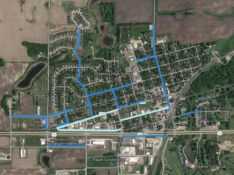
Figure M: The following highlights are additional recommendations from West Central Initiative planners. The dark purple indicates sidewalks that should be added. The light purple marks indicate areas of geography where no specific route is recommended, but it is suggested that there continue to be efforts to create safer routes for students who are walking and biking via paths that are poor, unsafe or not intended for foot traffic.

144 | Page HAWLEY SAFE ROUTES TO SCHOOL PLAN
THIS PAGE INTENTIONALLY LEFT BLANK
145 | Page HAWLEY SAFE ROUTES TO SCHOOL PLAN


