35 minute read
Action Plan Recommendations


ACTION PLAN RECOMMENDATIONS
EQUITY Goal: Incorporate equity principles into all areas of Safe Routes to School implementation.
1. City council, school board, city administration, and school administration review of equity resources available on the MnDOT Safe Routes to School web site.
From the MnDOT SRTS web site: “Safe Routes to School programs can make it safer to walk and bike to school by funding new and improved pedestrian and bicycle infrastructure, as well as activities to support and encourage active transportation. Equity in safe routes to school aims to ensure that funding and programs prioritize underserved areas that may suffer from disproportionate health problems and traffic safety issues, or have limited transportation options. In addition to improving access to school, Safe Routes to School efforts in disadvantaged communities provide opportunities for physical activity and can improve student attendance, both of which are linked with increased academic achievement.”
https://www.dot.state.mn.us/mnsaferoutes/resources/equity.html
2. Provide equity resources and/or training to city and school staff.
Sharing these resources with staff will allow the community to strive toward incorporating equity principles into their everyday work, to prioritize transportation funding and investments for underserved neighborhoods and neighborhoods with dangerous street conditions.
EDUCATION
Goal: Establish educational programs within the community to teach and foster good bicycle and pedestrian safety habits.
1. Implement an annual bicycle rodeo event to teach bicycle skills and safety to students.
Bicycle Rodeos are bicycle safety training events typically held after school or on weekends and open to the greater community. They are usually run for two to three hours and teach bicycle safety lessons and on-bike skills, usually in a station format (e.g., bicycle safety check, helmet fitting, instruction about the rules of the road, on-bike obstacle course, on-bike skills drills, etc.). While geared towards children, many of the lessons can be appropriate for adults as well.
Bicycle rodeos can be held as part of a larger event or on their own, and either during the school day or outside of school. Adult volunteers can administer rodeos, or they may be offered through the local police department. Key partners in implementing a bicycle rodeo event may (should) include teachers, League of American Bicyclists Cycling Instructors, and PartnerSHIP 4 Health.
2. Educate students about proper walking and bicycling etiquette through in-school and after-school bicycle and pedestrian safety education. a. Apply to host a Walk! Bike! Fun! training in Hawley, or send teachers from Hawley to Walk! Bike! Fun! training in another community. b. Utilize the Walk! Bike! Fun! curriculum to help students understand the rules of the road.
c. Identify the need for a bicycle fleet.
Observation results indicate that a portion of students did not exhibit proper walking techniques. Students were not using crosswalks and some were seen not watching for traffic when they were crossing the street. Some of the bicyclists also displayed improper techniques by riding through stop signs and even not looking before entering streets and intersection.
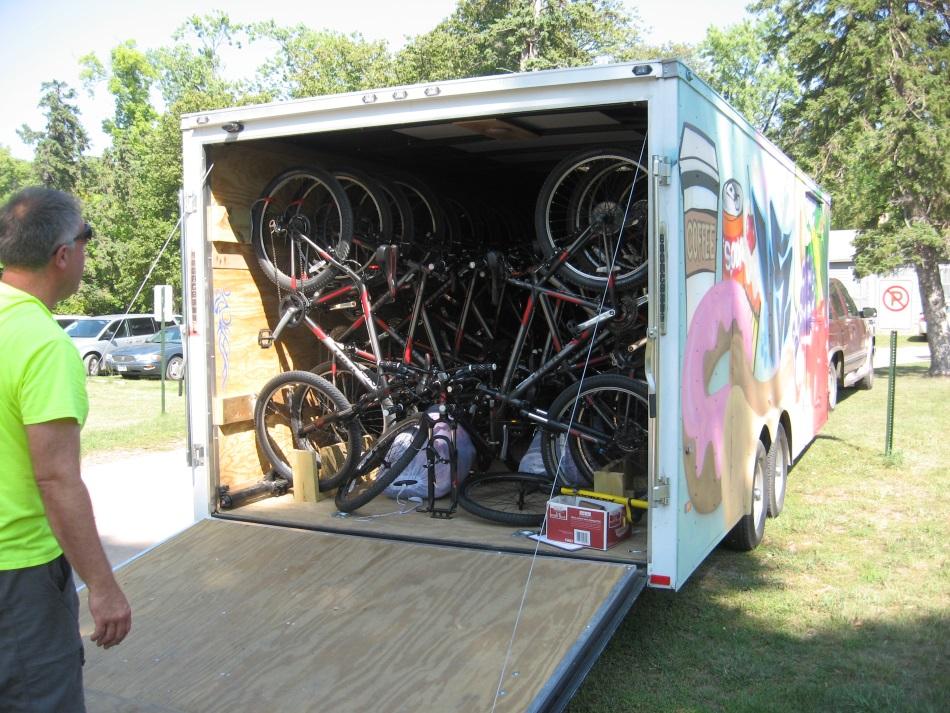
The Walk! Bike! Fun! curriculum is an in-classroom and real-world, on foot and on bike, educational resource and can help address improper walking and biking behaviors like that observed during the SRTS planning process. Taught by specially-trained school teachers, government staff and/or volunteers, this curriculum is intended for children ages five through thirteen. It teaches life-long skills related to traffic rules like identifying potential hazards and general biking and walking skills that enable students to walk and bike safely and comfortably to and around their communities. The curriculum addresses a variety of walking and bicycling topics and is endorsed by MnDOT. Finally, to engage students in the Walk! Bike! Fun! curriculum, the Hawley School District should identify the need for a bicycle fleet, or identify a nearby fleet they may be able to borrow (Figures 2 & 3).
12 | Page HAWLEY SAFE ROUTES TO SCHOOL PLAN
Figure 2: The Fergus Falls bike fleet is kept inside this towable trailer.
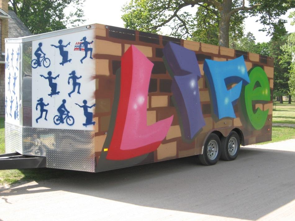
Figure 3: Some of the inspirational graphics painted onto the sides of the Fergus Falls bike fleet trailer.
3. Develop a school district safety campaign to build awareness of students walking and bicycling to and from school, and to encourage safe driving behavior among parents, high school students and passersby.
Observations by the SRTS team, comments from the public, and comments in the Parent Surveys indicate concerns about driver behavior around the schools. Their concerns are mostly on the major roadways in Hawley, such as 5th Street (County Road 33) and 7th Street near the school campus. A school safety campaign should be developed that builds awareness around students walking and bicycling to and from school. An effective safety campaign might utilize multiple forms of media to get the attention of parents, students and passersby. Primary outcomes are improved walking, bicycling and driver safety behaviors (particularly near the school), and youth empowerment.
4. Design a parent workshop to provide tools, resources and support needed to encourage parents and other community members to begin walking and bicycling for transportation.
A parent workshop for those living in and around Hawley can provide the tools, resources and support needed for parents to overcome some of the common barriers they noted to not allow their children to walk or bicycle to and from school. While distance was the most frequently cited barrier in the Parent Survey, traffic and weather were also commonly noted. While traffic is a real threat to student safety for those walking to school, it is something that can be mitigated to some degree through education and parent involvement. Topics such as how to be a responsible driver, starting a walking school bus, and launching a safety campaign can help mitigate the amount and speed of traffic near the school route.
5. If there is ever a desire to construct a blacktop playground at the Hawley Elementary
School, consider building and painting it with “play” road markings in a manner sometimes referred to as a “Bicycle Playground” or “Traffic Garden.”
Traffic gardens are common in Europe and are often painted onto elementary school playground surfaces. They include “play” traffic lanes, intersections with stop signs, painted sidewalks, marked crosswalks, solid and dashed yellow centerlines, turn lanes and even a traffic circle, all with the purpose of teaching children proper traffic and safety behaviors associated with walking and biking, as well as driving. While often not much more than paint on asphalt, they can be elaborate and complex with completely functioning traffic lights, railroad gates, etc. It is not required that this be located on school grounds and could be built in another part of town (Figure 4).
14 | Page HAWLEY SAFE ROUTES TO SCHOOL PLAN
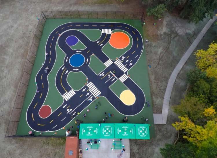
Figure 4: An example of a bicycle playground or traffic garden (photo via King County Parks)
For more Education ideas, see Minnesota SRTS Model Policies Tip Sheet (Appendix E) and the Minnesota SRTS Resource Center – Education:
http://www.dot.state.mn.us/mnsaferoutes/resources/education.html
ENCOURAGEMENT
Goal: Explore strategies to promote walking and bicycling through the identification of safe routes, organizing events, rewarding participation, and educating adults.
1. Explore the development of a remote school bus drop site; at less than ½ mile (~10-minute walk), the intersection of the SRTS path and Westgate Drive would be an ideal location for this.
In a rural school district where students can live five to ten (or more) miles away from the school, it is not practical to have these students walk or bike to school. Others may live close by but are confronted with traffic barriers like highways and/or railroad tracks. These students can still get the exercise benefits of walking to school if the school bus system gives them the option of walking a few blocks to school from a safe remote drop-off site. This would also allow these students to participate in walking and biking to school competitions (see below). A teacher or parent volunteer could assist the elementary school children who decide to participate.
2. Develop informational messages to be included in the monthly school newsletter or email blast, encouraging students to walk or bike to school and highlighting associated health benefits.
Monthly informational messages can raise awareness about the positive health and academic benefits associated with increased physical activity, such as walking and bicycling. To get information to parents, a short message could be included in the monthly school newsletter.
3. If not already policy, where safe to do so, explore the consolidation of bus stops so bused students are required to walk to a bus stop.
Front door pick-ups and drop-offs are common in many school districts but they minimize the amount of walking bused students can get on their trip to and from school. Requiring students to walk to and from a bus stop is one strategy for bused students to get more physical activity before and after school. It also can speed up travel times so students spend less time on the bus and more time either sleeping in the morning, studying and/or being physically active. Bus stops spaced 2-3 blocks apart would require no more than a 1.5 block walk to the stop.
4. Explore / develop a competition or challenge to reward students by tracking the number of times they walk or bike to school, including those that take the bus and opt to be dropped off remotely or participate in some sort of physical fitness activity like walking on school grounds, etc.
Competitions or challenges provide students with immediate, positive reinforcement. Beyond a walk and bike to /from school challenge, possible competitions or challenges are endless and could target individuals, classrooms or the entire school.
5. Explore / continue participation in the International Walk and Bike to School Day and the new Minnesota SRTS Winter Walk to School Day to encourage students and their families to try walking or biking to school.
International Walk and Bike to School Day attracts millions of participants all over the world. The intent is to encourage students and their families to try walking or bicycling to school for one day. In some districts with high busing numbers, events on this day might include a walk around school grounds and throughout the town for all students, or a remote bus drop-off which would allow all students to walk to school from that location. Depending on the response rate, these events could be extended into the future and turn into ongoing designated walking and bicycling days.
16 | Page HAWLEY SAFE ROUTES TO SCHOOL PLAN
Winter Walk to School day started in Canada in 2007. February 2017 marked the first year that the Minnesota SRTS program officially participated. Key partners might include law enforcement officials, high school students, teachers, parent advocates and PartnerSHIP 4 Health. A desired result is that youth become empowered and more connected to the health benefits of walking and biking and their environment as well.
6. Review relevant Hawley School District policies to ensure compatibility with SRTS goals and objectives, including transportation and wellness policies.
The School Wellness Policies: Safe Routes to School document, produced by the Public Health Law Center at the William Mitchell College of Law, provides detailed SRTS guidance specific to Minnesota. It can be found in Appendix D. It is suggested that the School District adopt these policies in whole or in part. An additional policy resource specific to Minnesota is the Minnesota SRTS Model Policies Tip Sheet which can be found in Appendix E. Furthermore, the SRTS National Partnership, in cooperation with ChangeLab Solutions (a multi-disciplinary, multi-government agency policy partnership), has developed an on-line SRTS District Policy Workbook. This resource is a comprehensive SRTS policy guide covering everything from general policies supporting SRTS to more advanced policies like “No Idling Policies” and “School Siting Policies.” This resource is best accessed on-line and can be found at:
http://www.changelabsolutions.org/safe-routes/welcome
7. Investigate the feasibility of walking school buses for students from various neighborhoods within the Hawley city limits.
A walking school bus is a group of students walking to and from school with chaperones, usually parent and/or other adult volunteers. This can be a fun, secure, healthy and easy opportunity for students to be physically active. A walking school bus can provide front door pick-up and drop-off of students along the way, which can allay most parents’ fears. It can be done daily or just on certain days of the week and/or depending on weather conditions. Explore the demand for a walking school bus and if parents or other citizen volunteers are interested in taking turns walking students as “drivers”. Outreach to parents could be done via the parent newsletter. The hardest part to operating a walking school bus is finding enough dedicated volunteers to act as “drivers.” But active elderly members of the community have been recruited to perform this task in other towns and cities with very successful results. Routes along the Marshall Avenue, 2nd Street, and Hipple / School Avenue corridors are most likely to be feasible and provide the most utility.
For more Encouragement ideas, see Minnesota SRTS Model Policies Tip Sheet (Appendix E) and the Minnesota SRTS Resource Center – Encouragement: http://www.dot.state.mn.us/mnsaferoutes/resources/encouragement.html
ENFORCEMENT
Goal: Address traffic and safety concerns by identifying and implementing enforcement measures within the school walk and bike zone.
1. Continue Hawley Police Department presence and vehicle access closure at the intersection of 7th and Reno Streets.
The presence of law enforcement officers near the school helps to reduce vehicle speeds, improves compliance with speed limits around the school and increases the likelihood of vehicles yielding to pedestrians (Figure 5). In addition, the closure of the driveway north of Reno Street improves safety and convenience not only for school bus traffic, but for students walking and biking as well.
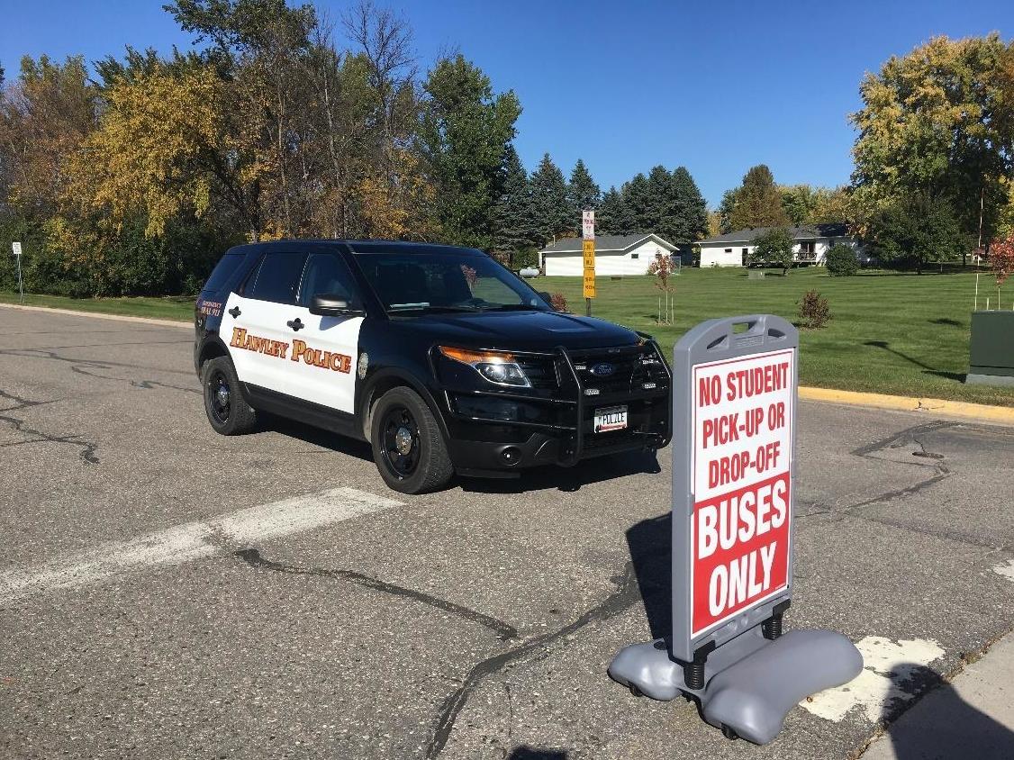
Figure 5: Hawley Police near the intersection of 7th and Reno Streets.
18 | Page HAWLEY SAFE ROUTES TO SCHOOL PLAN
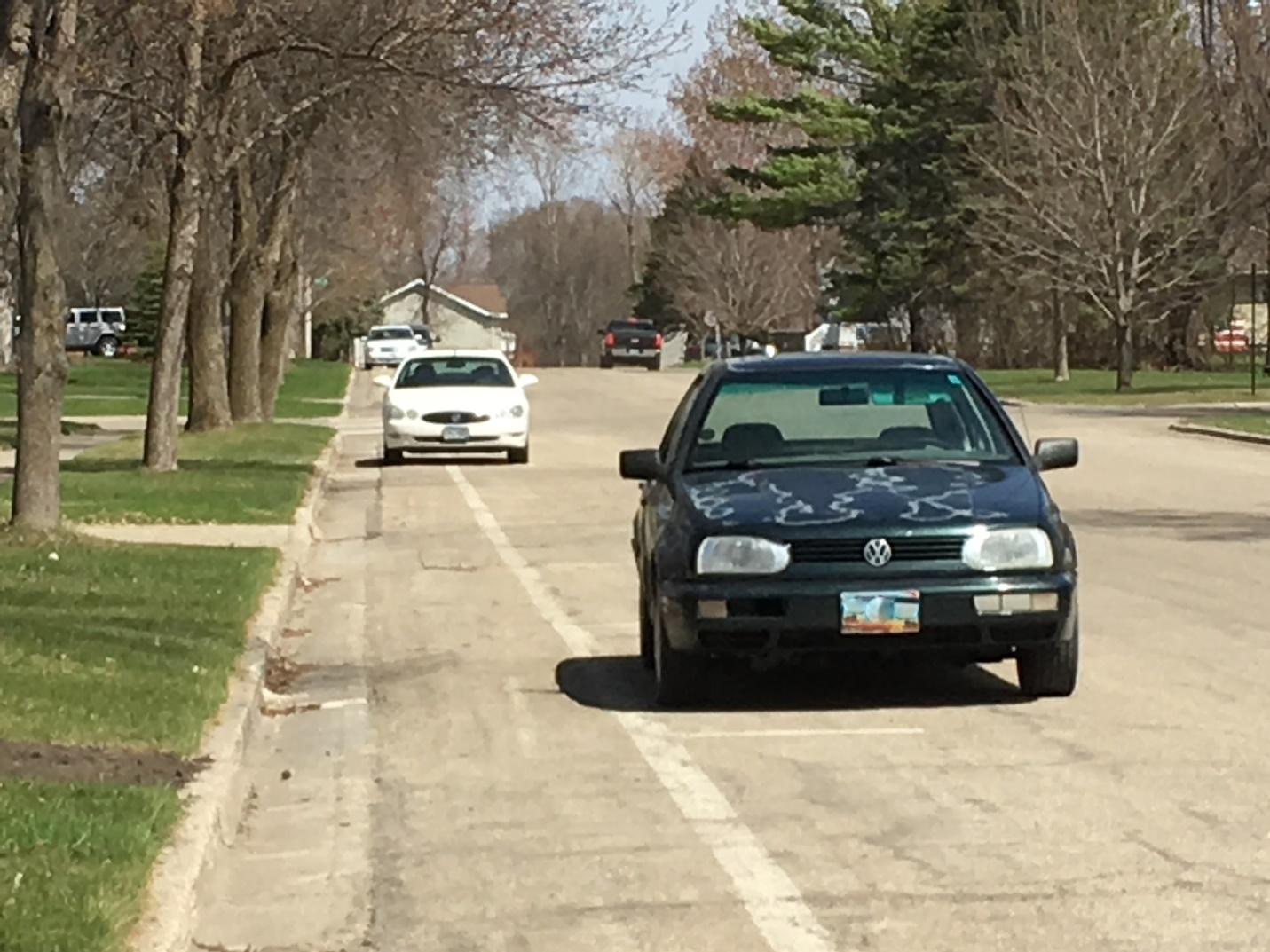
2. Educate and enforce parking restrictions in the walking lane along Reno and 1st Streets.
A mixture of compliance and non-compliance relating to parking along the Reno Street and 1st Street walking lane was observed on multiple visits to Hawley (Figure 6). This pattern indicates that confusion exists about parking regulations along the walking lane. A progressive system of education (perhaps via city newsletter), then police-issued warnings, followed ultimately by tickets, should improve compliance.
Figure 6: Vehicles parked along and in the Reno Street walking lane.
3. Explore options to add adult crossing guards at the following locations:
• 7th and Joseph Streets • 8th and Joseph Streets • 7th and Reno Streets (Hawley PD may be able to assist at this location)
Note that some of the proposed engineering improvements around the school may negate the need for crossing guards stationed at the school.
The presence of a trained adult crossing guard can be of invaluable importance to student safety at locations with busy and/or fast-moving traffic. They often also act as a second pair of more experienced eyes that can see hazards of which young children may not be aware. Also, crossing guards can help with the traffic flow of parents picking up and dropping off students. Adult crossing guards have the added benefit of acting as a source of encouragement to students and reassurance to parents. This person could be a school employee, a new hire, or an adult volunteer.
4. Remind residents (and enforce by citation if necessary) of Minnesota State parking laws per Statute 169.34 PROHIBITIONS; STOPPING, PARKING.
Cars parked in driveways across sidewalks were not regularly observed within Hawley (Figure 7). However, while this causes no more than a minor nuisance
for able-bodied persons walking by during warm weather months, cars parked across the sidewalk can become a
significant obstacle during times of heavy snowfall and will always block the safe passing of pedestrians with disabilities. Parked cars blocking sidewalks are very likely a violation of the Americans with Disabilities Act.
Figure 7: Parked vehicles and other objects blocking a sidewalk in Hawley.

20 | Page HAWLEY SAFE ROUTES TO SCHOOL PLAN
And while not observed as a systemic problem in Hawley, it is also illegal per Statute 169.34 to park: within an intersection, on a crosswalk, within 20 feet of a crosswalk at an intersection, within 30 feet upon the approach to any flashing beacon, stop sign, or traffic-control signal located at the side of a roadway, etc., (please see complete statute for all parking restrictions).
5. Identify the most effective form of automated speed feedback sign and investigate the possible installation (permanent or temporary) at strategic locations within Hawley. A possible location might be 5th Street (County Road 33) north of Reno Street, near the
Hawley Senior Living, facing southbound traffic.
Complaints of speeding came from members of the SRTS team and the greater community and are a frequently-noted problem in many Minnesota communities. Vehicles driving at speeds that were perceived to be unsafe were observed during the SRTS planning process. Speed feedback signs are an uncontroversial and effective means of slowing traffic and have been used in communities across Greater Minnesota. Using radar to detect a vehicle’s speed, the signs will display the speed of the oncoming vehicle to show the driver if they are driving above the posted limit. If vehicles are detected driving over the limit, the sign can be programmed to flash the detected speed, sometimes with a flashing strobe light to ensure the driver’s attention. It is recommended that Hawley, with the help of county and MnDOT officials, identify the most effective form of automated speed feedback and exact locations for deployment.
6. Keep trees and other vegetation trimmed to allow for safe passage along sidewalks.
The City of Hawley has the option of trimming vegetation on its own or could enlist the assistance of residents via letters or reminders in the city newsletter. Current city code requires 8’ clearance of any branches overhanging a public sidewalk.
7. If not in practice already, rescind parking privileges to high school students observed driving in an irresponsible manner while arriving and leaving the school grounds.
Investigate the possibility of extending such restrictions to any student who receives two or more traffic citations and is found guilty of those moving violations.
Being able to drive a private automobile to school and park it on school property is a privilege. Irresponsible driving behaviors by students near the school and around Hawley should not be tolerated as the consequences can easily be fatal. Several parents of younger students noted the driving behaviors of high school students as a deterrent to allowing their children to walk and/or bike to and from school.
For more Encouragement ideas, see Minnesota SRTS Model Policies Tip Sheet (Appendix E) and the Minnesota SRTS Resource Center – Enforcement:
http://www.dot.state.mn.us/mnsaferoutes/resources/enforcement.html
ENGINEERING
Goal: Improve the existing infrastructure within the community to ensure active transportation is encouraged and made safe.
Note – All the following recommended proposals are made via a planning-level analysis. They may need further vetting and refinement, including that of a licensed engineer, to determine specific implementation strategies. In addition, some recommendations may need further refinement via an additional, in-depth planning process. The recommendations below are listed in a general order of priority, although some lower-priority items may be implemented sooner due to a variety of factors including cost and ease of implementation.
1. Investigate installation of temporary – followed by permanent – curb extensions (also known as “bump-outs”) at these key intersections near the school, in order of priority:
• 7th and Joseph Streets • 8th and Joseph Streets • 7th and Reno Streets • 7th and Elizabeth Streets
Bump-outs have a traffic calming effect, reduce the distance that pedestrians need to spend in the street with automobiles, can prevent illegal parking of vehicles too close to a crosswalk and/or stop sign (which can block a driver’s view of these traffic control devices) and can aid in making pedestrians and stop signs more visible to drivers by placing them in a more conspicuous, easily-seen locations without being in the roadway. Sidewalk bump-outs can be engineered to be mountable when large heavy trucks need to turn at bump-out intersections.
Temporary, low-cost installation can be employed on a trial basis to test these traffic calming measures before more permanent and expensive installations are employed. Use best local judgment when prioritizing installations, and when possible, coordinate installations with other road and infrastructure projects to take advantage of potential cost savings.
22 | Page HAWLEY SAFE ROUTES TO SCHOOL PLAN
2. Continue with planned implementation of the Heartland Trail in Hawley, as well as these previously planned SRTS sidewalk routes:
• Reno Street between 5th and 7th Streets • Joseph Street between 8th Street and Westgate Circle • 10th Street between Joseph and Main Streets
3. Install sidewalks, crosswalks and curb ramps throughout Hawley as per the recommendations seen in Figure 8.
Ensure that all improvements meet the latest Americans with Disabilities Act Accessibility Guidelines (ADAAG) and the Public Right-of-Way Accessibility Guidelines (PROWAG). All sidewalks should be a minimum of 5-6 feet in width; sidewalks adjacent to the school should be a minimum of 8-10 feet wide. Sidewalks within ¼ mile of the school campus and along other key routes may need to be wider than the standard 5-6 feet, due to higher pedestrian volumes.
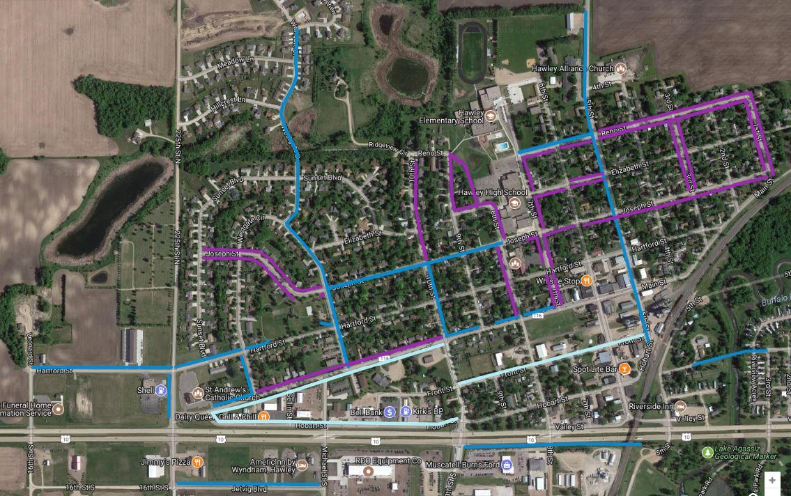
Figure 8: Sidewalk recommendations. Purple lines illustrate sidewalks recommended by WCI. Blue lines illustrate sidewalks / multi-use paths (dark blue) and on-street pedestrian routes (light blue) recommended by MetroCOG as included in the 2016 Hawley Comprehensive Plan.
4. Install other new sidewalks in accordance with recommendations in the 2016 Hawley
Comprehensive Plan and this Safe Routes to School Plan.
Use best local judgment when prioritizing installations, and when possible, coordinate installations with other road and infrastructure projects to take advantage of potential cost savings.
5. General sidewalk / crosswalk recommendations:
a. Ideally, all streets in the community would provide sidewalks on both sides; it will take time to build out such a system, and priority should be given to the specific routes identified above.
b. Repair / replace existing sidewalks as appropriate. Build new sidewalks in areas that have obvious network gaps.
c. Continue to paint and properly maintain crosswalks at all intersections adjacent to the school.
d. Maintain all existing painted crosswalks at all other pedestrian crossings throughout
Hawley.
E. Sidewalk, crosswalk and curb ramps should be improved in the following priority order: I. Locations adjacent to the school campus II. Locations within ¼ mile of the school campus III. Locations within ½ mile of the school campus IV. All other proposed improvements should be made as opportunity and funding allow.
6. In conjunction with sidewalk improvements, investigate the installation of pedestrianactivated crosswalk beacons like a Rectangular Rapid Flashing Beacon (RRFB) in conjunction with high visibility, “Continental” style crosswalks to increase driver yielding rates at the intersection of Joseph Street and 5th Street / CSAH 33.
“Rectangular rapid flashing beacons (RRFBs) are active warning devices used to alert motorists of crossing pedestrians at uncontrolled crossings. They remain dark until activated by pedestrians, at which point they emit a bright, rapidly-flashing yellow light, which signals drivers to stop. Studies suggest that RRFBs can significantly increase yielding rates over standard pedestrian warning signs.
24 | Page HAWLEY SAFE ROUTES TO SCHOOL PLAN
Results have shown that motorist yielding can be increased from baselines averaging 5% to 20% with the standard pedestrian warning sign to sustainable yielding rates of 80% with this device.
RRFBs should be installed on both the right and left sides of the crosswalk, or in a median if available.”
- Pedestrian and Bicycle Information Center Safe Routes to School Engineering Guide (http://guide.saferoutesinfo.org/pdf/SRTS-Guide_Engineering.pdf)
7. Explore options for a trail connection from future residential developments north of the school campus (Figure 10).
The school property north of the main campus presents an opportunity for trail connections into the school
campus from future residential developments. In the platted areas of the Prairie Hills development, an easement could be secured from the
developer between two currently unimproved lots, allowing for construction of a sidewalk or trail
between properties before homes are built (Figure 9).
Additionally, if future residential development occurs to the northeast of the school campus in accordance with the 2016 Hawley Comprehensive Plan, explore options for a trail connection from those areas into and through the same school property. Considerations should be made for routing around the existing athletic fields in this area.
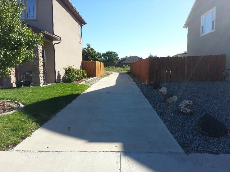
Figure 9: Example of a sidewalk route between two houses.
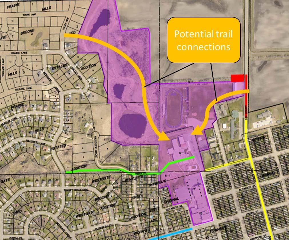
Figure 10: Potential trail connections illustrated in orange; school property is shown in purple. Base image from Hawley TAP application / Moore Engineering.
26 | Page HAWLEY SAFE ROUTES TO SCHOOL PLAN
8. Explore options for grade-separated bicycle / pedestrian crossings of the BNSF railroad and
Highway 10.
a. The BNSF railroad and Highway 10 corridors are the most dangerous crossings for people walking and biking in Hawley. b. There is a significant equity issue with mobile home communities that are separated from the school, athletic facilities, pool, and other destinations in the community. c. Ideally, a grade-separated trail (either over or under) would be the safest option. While expensive, projects like this would qualify for federal Transportation Alternatives Program (TAP) funding, reducing the local cost burden. d. Examine separated-grade crossings in Detroit Lakes and Moorhead for nearby examples of similar implementations.
9. As an interim solution (or if a gradeseparated railroad crossing is not deemed feasible), explore options to relocate and improve the existing atgrade pedestrian crossing of the BNSF railroad to assure crossings meet the latest ADA PROWAG standards (Figure 11).
The existing crossing that aligns roughly with Front Street does not meet current
accessibility guidelines. It is not in an optimal location, based on observations of where people are currently crossing closer to Hobart Street. An alignment with the bridge over the Buffalo River and Hobart Street should be explored as an option.

Figure 11: Tactile strips, lights, bells and gates to block pedestrian and bicycle traffic, along with smooth and robust precast concrete panels filling the gaps between and around the railroad tracks, make this crossing in Fergus Falls about as safe and ADA compliant as one can be for pedestrians and bicyclists.
10. Improve the pedestrian bridges across the Buffalo River, north and south of Highway 10.
Recommendations to improve these bridges are identified in the 2016 Hawley Comprehensive Plan.
For the purposes of Safe Routes to School, the bridge north of Highway 10 that connects the mobile home community to the rest of Hawley should be the priority, as it serves as a more direct safe route to school. In addition, improvements should be made to the connections leading to the bridge from each end of Hobart Street (east and west of the bridge).
11. Explore relocation of the bike racks at the elementary school to be closer to the
main school entrance
(Figure 12).
Moving the bike racks closer to the school provides an incentive and encourages kids to bike to school. As this recommendation
is considered, keep in mind pedestrian and vehicle flows (particularly school buses) near the school entrance. Additional
infrastructure beyond the racks may be deemed necessary.
12. Improve and expand availability of bike racks at the high school.
One great way to determine the need for a bike rack is to observe where bikes are currently being parked. At the high school, there is a clear desire for bike parking in the grassy area to the west of the stairs leading to the main entrance (Figure 13). Another consideration for this area is to locate a bike repair station in this general area (see Engineering recommendation #24).
The existing bike rack to the east of the main entrance is also well-utilized and should remain in place. One option to consider would be to improve the style of rack to one that is more userfriendly and better complies with current bike parking standards, as published by the Association of Pedestrian and Bicycle Professionals (APBP).
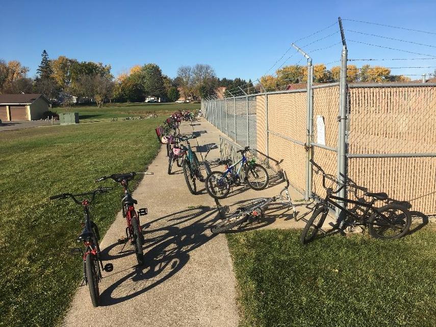
Figure 12: Bikes parked along the south side of the pool, near the elementary school.
28 | Page HAWLEY SAFE ROUTES TO SCHOOL PLAN
13. Consolidate school bus stops to the existing location near the
elementary school.
Consolidating to one bus stop will reduce traffic congestion since the buses won’t have to drive the
short distance between
schools. Also, some buses may turn on Reno or Elizabeth Streets, relieving some congestion at the intersection of 7th and Joseph Streets. This will make it safer for students
who are walking and biking to and from school to cross 7th Street.

Figure 13: Bikes parked in the grassy area west of the main high school entrance.
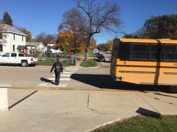
Figure 14: While crossing 7th Street, a student’s visibility is blocked by the school bus parked close to the crosswalk.
The recommended location would not
impact younger students, and students at the high school would benefit from slightly more physical activity at the beginning and end of the school day. In addition, a parked bus was observed blocking visibility near the crosswalk at 7th and Elizabeth Streets; consolidating the bus stops would eliminate that hazard as well (see Figure 14).
14. Explore options to relocate and/or provide alternative parent drop-off / pick-up zones to
areas west of the school:
a. For the high school, along 8th Street between Joseph and Elizabeth Streets b. For the elementary school, along 9th Street, south of Reno Street
Some parents are already using these areas as alternatives, so formalizing them may provide safety benefits for students being dropped off, as well as students walking to and from school in these areas, as they have limited sidewalks. Other benefits could include reduced congestion in areas closer to the schools, as well as giving students being dropped off or picked up an opportunity for slightly more physical activity at the beginning and end of the school day. One consideration for this recommendation would be for the additional traffic in the residential areas, that may not see much school-related traffic at present. Also, to accommodate this, sidewalks may need to be installed/expanded.
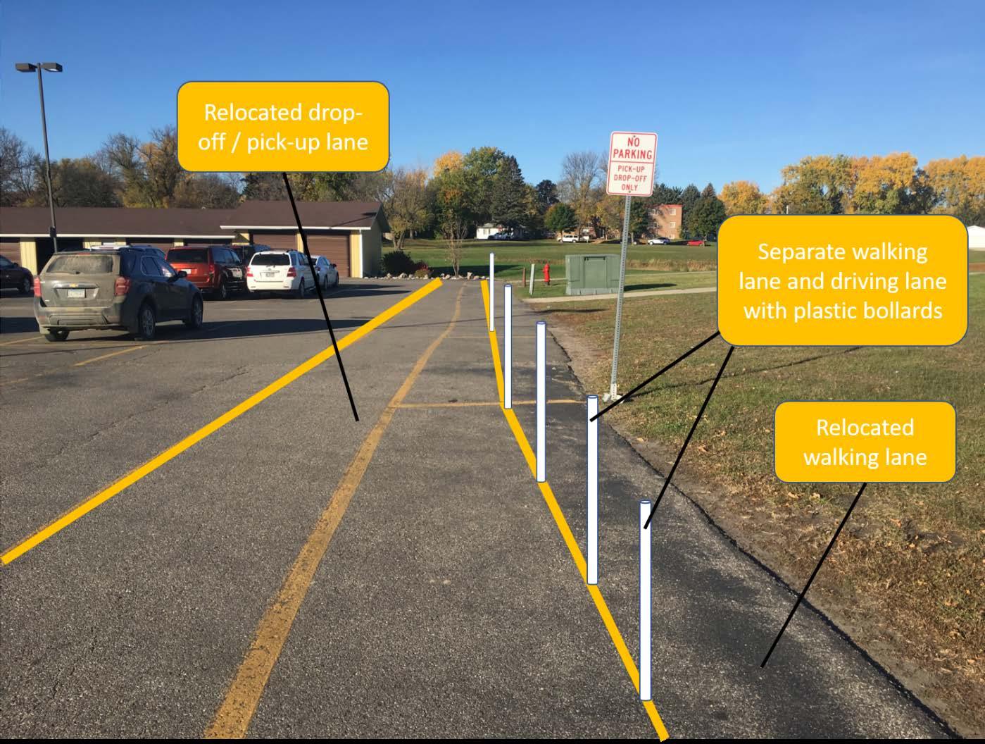
15. Reconfigure /enhance the current parent pick-up / drop-off zone so that vehicles do not cross the striped walking lane.
The current parent pick-up / drop-off zone is located on the north side of the parking lot located between the elementary school and high school, adjacent to a striped walking lane in the parking lot. The primary issue with these lanes, as they are configured today, is that there is a significant conflict between students walking and parent vehicles, as the vehicles are required to cross the walking lane to enter and exit the pick-up / drop-off zone.
A long-term solution would be to build a sidewalk adjacent to the parking lot on the north side, which would serve as a safe area for students to be picked up and dropped off, as well as a safer area for students to walk than the parking lot.
An interim solution could be to simply swap the walking lane and pick-up / drop-off lane, which would only involve restriping the lanes. An enhanced interim solution would involve the placement of flexible plastic bollards to provide some physical separation between the walking lane and the pick-up / drop-off lane (Figures 15 & 16).
30 | Page HAWLEY SAFE ROUTES TO SCHOOL PLAN
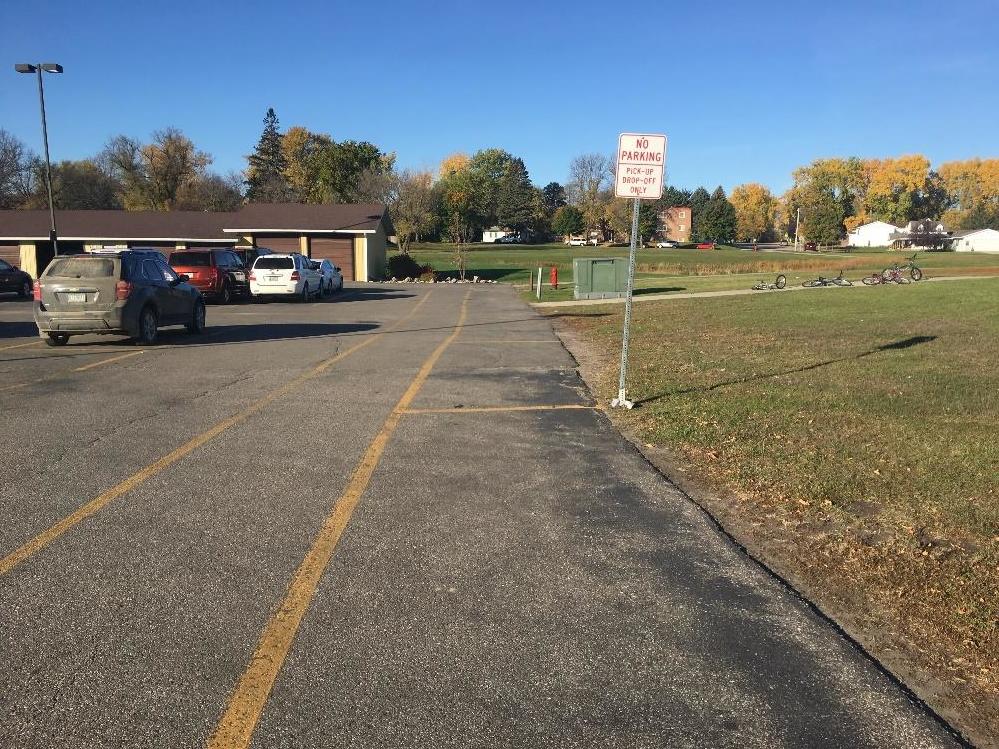
Figure 15: (left) Existing dropoff / pick-up lane configuration.
Figure 16: (below) Proposed interim drop-off / pick-up lane configuration.
16. Until a sidewalk can be added to Reno and 1st Streets, regularly maintain the striping and pedestrian symbols in the existing walking lane.
As mentioned in the Observations and Walking Audit section of this plan, the City is to be commended for implementation of the walking lane along Reno and 1st Streets. Temporary installations like this can provide valuable information and inform future infrastructure investments. The City is encouraged to try similar temporary installations as recommendations from this plan are discussed. This specific installation of the walking lane has some challenges, and the Reno / 1st Street corridor would ideally be better-served by a permanent sidewalk.
In the Enforcement Recommendations section, it is noted that there are issues with vehicles being parked in the walking lane. In addition, the walking lane is not ADA accessible; the cross-slope of the roadway in that location likely does not meet ADA guidelines. While the walking lane is similar in width to a standard sidewalk, the fact that the walking lane straddles the bituminous roadway surface and the concrete gutter pan make it challenging for people with limited mobility to navigate.
Until a sidewalk is installed along the Reno and 1st Street corridors, it is recommended that the city continue to regularly maintain both the striping and pedestrian symbols in the walking lane. In conjunction with recommendations in the Enforcement section, drivers should be educated and parking restrictions enforced along Reno and 1st Streets.
17. Upon completion of – or in conjunction with – an improved pedestrian crossing of the railroad, coordinate with BNSF Railroad and MnDOT to investigate the installation of fencing along the railroad tracks in Hawley.
This can help to prevent pedestrian trespass on the railroad right-of-way and focus pedestrians to legal crossing locations with proper pedestrian accommodations. Decorative fencing could be used in residential areas along Main Street, while a more utilitarian option might be used in the industrial areas near the Hawley Co-op Elevator.
18. Work with MnDOT and the State Legislature on the posting of 20-mph speed limits on all city streets that are not part of the state or county networks.
It is suggested that all streets within Hawley that are not a part of the state and county networks be posted at 20 mph. Lowering traffic speeds is a solidly-proven traffic safety countermeasure and lowering the speed limits can be done very inexpensively.
32 | Page HAWLEY SAFE ROUTES TO SCHOOL PLAN
Nearly all the roads that fall under this recommendation are residential in nature and have limited potential to serve regular through-traffic.
19. Investigate composing a city ordinance requiring that all new residential and commercial development be required to install sidewalks where the property in question faces the street.
In 2015, the state legislature passed a law requiring communities to adopt “subdivision regulations that require safe routes to school infrastructure in developments authorized on or after June 1, 2016” in order to be eligible for state SRTS infrastructure funding. This statute does not apply to state non-infrastructure funding, nor does it apply to federal SRTS (TAP) funding.
However, it is recommended that the City of Hawley review their city code and adopt a city ordinance that would meet this requirement – both to qualify for state SRTS funding, and more importantly, to ensure that sidewalks are installed as part of the development of new residential areas.
20. Where practicable, set sidewalks as far
back as possible from the roadway curb to create a buffer between pedestrians and motor vehicle traffic.
Such buffers can reduce traffic stress on
pedestrians and make walking safer and more enjoyable, while providing a place for streettrees to grow. These buffers are even more important on busier roadways with higher traffic volumes, faster vehicle speeds, and/or significant heavy truck traffic (Figure 17).
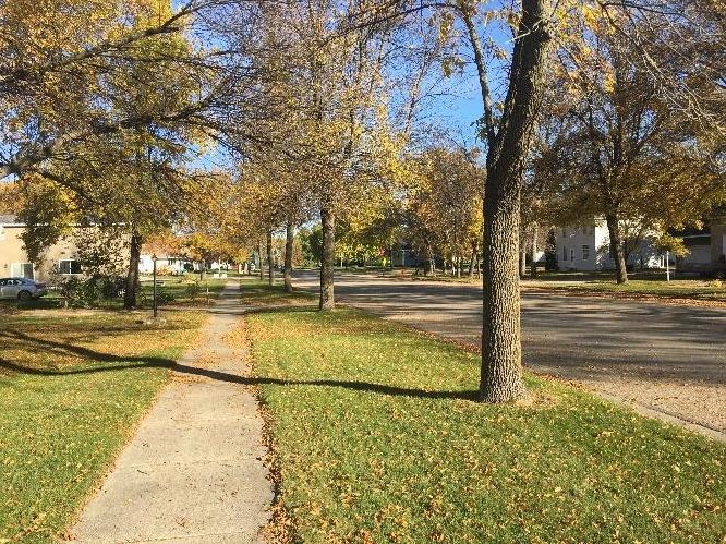
Figure 17: Boulevard trees and wide boulevard along 6th Street in Hawley.
21. Where not already present, plant trees within the public ROW, preferably between the sidewalk and the curb if there is adequate space in the boulevard (≥4 feet for small tree species, ≥6 for medium to large trees). Be mindful to keep sightlines open and free of obstructions at intersections and driveways.
Not only do trees provide a physical barrier between an errant car and a pedestrian, but a colonnade of large overarching trees can provide a traffic calming effect by closing in the perceived
width of the roadway and increasing the sense of speed. Trees also provide a break from the persistent prairie winds around Hawley that can make winter temperatures that much more formidable. During hot summer months, they provide a shaded oasis making walking and biking more attractive to students and residents alike. (Figure 17)
22. Encourage infill residential development and/or development within close proximity
to the school to enable the possibility of more students walking and/or biking to and
from school, and to minimize busing costs. The 2016 Hawley Comprehensive Plan identifies both single-family residential and multi-family residential growth areas northwest of the school campus, and within ½ mile of the campus (Figure 18).
As these areas are developed, assure good walking and biking connections, as suggested in engineering recommendation #7 above.
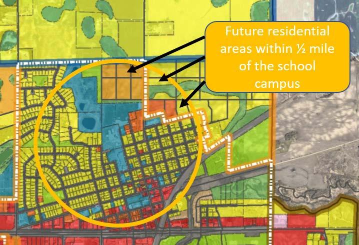
Figure 18: Future residential areas located within ½ mile of the Hawley school campus. Base image from 2016 Hawley Comprehensive Plan.
34 | Page HAWLEY SAFE ROUTES TO SCHOOL PLAN
23. On a case-by-case basis, if and when the need arises, encourage / require developers to construct multi-use shortcut pathways to make it quicker, easier and timelier for people to walk and bike to school as well as other destinations in Hawley.
24. Consider installing a bicycle repair station near the high school entrance where the bicycle racks are already located in accordance with the
Association of Pedestrian and Bicycle Professional (APBP) guidelines.
Outdoor bicycle repair stations (Figure 19) are a great way to encourage bicycling. They provide a way to make sure that bicycles are in good working order before students leave school for the day. This enables the student to make minor repairs that may otherwise leave them stranded, while teaching students basic mechanics and self-reliance. A typical station is equipped with a repair stand that holds the bike from the saddle, a heavy-duty, allweather bicycle pump and basic tools attached to the stand with theft resistant
cables that allow a person to make most basic repairs. They can also be of use to members of the public when not needed by students and/or faculty.
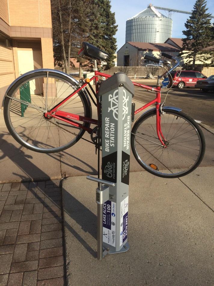
Figure 19: A bicycle repair station with a heavy-duty, allweather pump, installed in the summer of 2015 at the Fergus Falls Public Library.
For more Engineering ideas, see Minnesota SRTS Model Policies Tip Sheet (Appendix E) and the Minnesota SRTS Resource Center – Engineering: http://www.dot.state.mn.us/mnsaferoutes/resources/engineering.html
EVALUATION
Goal: Evaluate the effectiveness of programming by tracking baseline data and, in addition, actively work on improvement, based on results.
1. Administer the student travel tallies at least once per year to track the number of students walking and bicycling in comparison to the 2017-18 baseline results.
To track the results of implemented programming, it is recommended that the Hawley School District administer the student travel tallies at least annually. The results will indicate the number of students walking and bicycling, which in turn will identify the effectiveness of programs. If possible, try to conduct the student travel tallies more than once per year so it is possible to capture travel data during periods of inclement weather, particularly rain and snow, to see how that affects student travel mode choice. This data will also be useful when applying for noninfrastructure or infrastructure funding.
2. Administer a parent survey questionnaire once every two to three years to track and analyze school travel behaviors and parents’ perceptions.
The parent survey tool tracks and analyzes student travel behaviors and parents’ perceptions of walking and bicycling. This survey should be conducted no more than biannually as attitudes are not likely to change that quickly. If done too frequently, parents may not be as inclined to complete the survey. Results can then be compared to the baseline analysis completed in the fall of
2017.
3. Consider utilization of MnDOT District 4 bicycle and pedestrian counting equipment.
Explore options for permanent bicycle and pedestrian counting equipment.
To track the number of people walking and biking, it is recommended that the City of Hawley work with partners at MnDOT and West Central Initiative to utilize the portable bicycle and pedestrian counting equipment that is available for use by communities in MnDOT District 4. If it is determined that a specific location may benefit from the installation of permanent counting equipment, that option could be explored as well.
For more Evaluation ideas, see Minnesota SRTS Model Policies Tip Sheet (Appendix E) and the Minnesota SRTS Resource Center – Evaluation:
http://www.dot.state.mn.us/mnsaferoutes/resources/evaluation.html
36 | Page HAWLEY SAFE ROUTES TO SCHOOL PLAN
OTHER
Goal: Create partnerships with local businesses and organizations to increase support and encouragement of active transportation.
1. Identify opportunities or partners to fund bicycle helmets for educational events like bike rodeos and/or Walk! Bike! Fun! training events.
Goal: Work to ensure all City policies and ordinances are supportive of active transportation.
2. If elderly and/or disabled residents are not physically and financially able to remove the snow from the public sidewalk in front of their residence, look to city staff to remove snow and/or establish a volunteer snow removal program where neighbors, possibly even students help to remove the snow from these sidewalks.
For example, the City of Battle Lake has identified priority Safe Routes to School sidewalk corridors, which the City maintains in the winter.
3. To maintain the political popularity of SRTS and sidewalks, it is suggested that the City refrain from assessing adjacent property owners when installing and replacing sidewalks unless there is undeniable evidence that the adjoining property owner has removed or damaged the sidewalk within the recent past.
Sidewalks should be viewed as a public good that are more often of greater benefit to people that live away from the property in question. As such, the cost of regular repair and replacement of the sidewalk should be borne by the community as a whole as is often the case with city streets.


