1 minute read
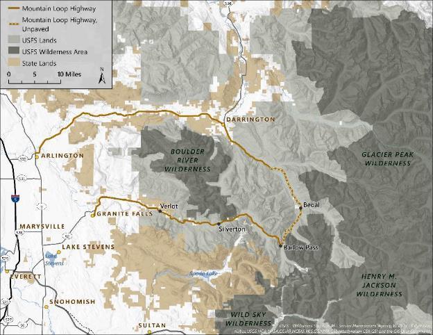
Figure 1. Map of the Mountain Loop area


Figure 1. Map of the Mountain Loop area
The Mountain Loop area includes the homelands of Indigenous tribes of the Pacific Northwest, including the Sauk-Suiattle Indian Tribe and Tulalip Tribes. The Sauk-Suiattle Reservation is located near the Sauk Prairie off Highway 530 and tribal members actively use the area. In recent history, the area was a used as a site of mining and logging by European settlers. An historic silver mine at Monte Cristo is now an abandoned town site and heritage destination. Today, the Mountain Loop area is a popular recreation destination for hikers, climbers, fishers, rafters, campers, and skiers. Many visitors also drive through the loop for scenic vistas, picnicking, or accessing the Sauk or Stillaguamish Rivers. The area is managed by several agencies, including the USFS (Mount-Baker Snoqualmie National Forest), the Washington State Parks (Mount Pilchuck State Park), and Washington Department of Natural Resources (Morning Star Natural Conservation Area), and also includes several private landholdings. The area includes numerous developed and group campgrounds, trailheads, and developed sites as well as a USFS visitor center. Trails in the Mountain Loop area connect with three federally designated wilderness areas (Boulder River, Glacier Peak, and Henry M. Jackson), and trails provide a connection to the Pacific Crest National Scenic Trail.
Advertisement