FARM FRESH
How Can Satellites Improve Crops? by Brian Hefty
Recently, an ag tech company called Farmers Edge made an
yields as they harvested. Once harvest is completed, this data
announcement that as part of their services, they would be able
gets thrown into a map, so a farmer can now see grain yield in
to provide as frequent as daily satellite imagery to farmers. For
each area of every field.
the first time, a farmer will be able to look at a satellite image of each field almost every 24 hours.
This is usually when I start getting phone calls. “Brian, why do you think this area of my field yielded so poorly?” The problem
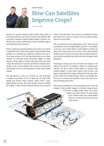
Before I explain its potential benefits, picture the size you think
is once the crop is off the field, it’s pretty difficult to figure out
a satellite should be. When I ask people how big they think these
what went wrong earlier in the season. That’s where satellite
satellites are, I typically get responses anywhere from one to
imagery comes in. If you can see poor spots in fields mid-season,
three times as big as a car. The interesting thing to me is these
you now have the ability to go to that area and investigate what’s
satellites are extremely small, measuring roughly 12 inches
happening.
long by 4 inches high by 4 inches wide, plus some very small “wings” that stick out on each side. Just like how computers have
Technology is coming soon that will allow this imagery to be
shrunk in size, so have satellites. The cost has also come down
refined even further. For example, I talked to a company who
dramatically, so now it is economical for a farmer to get satellite
said they are able to detect certain weeds in a pasture using
imagery.
satellite imagery. At some point, farmers may be able to get reports along with their imagery telling them if the poor spots
The big question is, how can a farmer use this technology
are the result of low fertility, disease, insects or something else.
to improve crop yields? As I see it right now, it’s kind of like
But for now, scouting those problem areas is the only way to
getting your harvest maps in-season. Here’s what I mean:
start narrowing down issues.
Approximately 20 years ago, yield monitors became available for combines. These monitors allowed farmers to see live grain
Many types of satellites serve various purposes, but for me, the thought of daily satellite imagery is exciting. Going forward, it will lead to higher yields, lower costs (since imagery may allow farmers to treat certain areas of fields rather than whole fields), better use of resources and increased net farm income.
22
VITALBYPOET.COM