The Maritime History of Newry and Mourne
An Education Resource Pack for Teachers

School visiting times
10.00am - 2.30pm Monday to Friday. School visits must be booked in advance.
The museum offers an education service for schools. Teachers are encouraged to contact the Museum Education Officer who will tailor curriculum-linked lessons to their requirements using the Museum Collection.
Newry and Mourne Museum offers a range of educational opportunities for all visitors. We provide a range of workshops for local schools, lectures, guided tours of the Museum, reminiscence sessions and various learning programmes to the general public. Full details are on the museum website at www.bagenalscastle.com
Free car parking is available on site.
For further information contact the Education Officer, Declan Carroll at 028 3031 3178, email declan.carroll@ newryandmourne.gov.uk
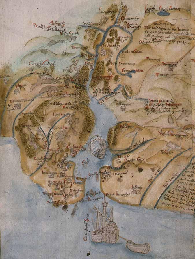
Front cover: Detail from Robert Lythe’s map of the County Down coast showing Carlingford Lough c.1570 TNA MPF/89
Newry and Mourne Museum at Bagenal’s CastleThis resource pack illustrates the variety of material available at the Museum relating to the maritime history of Newry and Mourne and the Carlingford Lough area.
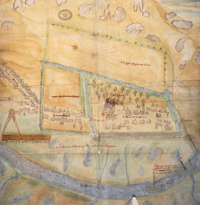 Robert Lythe’s map of Newry (c. 1570) showing barques on the Clanrye River TNA MPF/82
Content Information booklet
Introduction 3 Useful Information 4
About this education resource pack 4
Prehistoric Carlingford Lough 6
Medieval people and the sea 8
From monastic settlement to modern town 10
Newry Canal 12
The modern Port of Newry 14
Acknowledgements 16
Photocards for use with information booklet (in pocket)
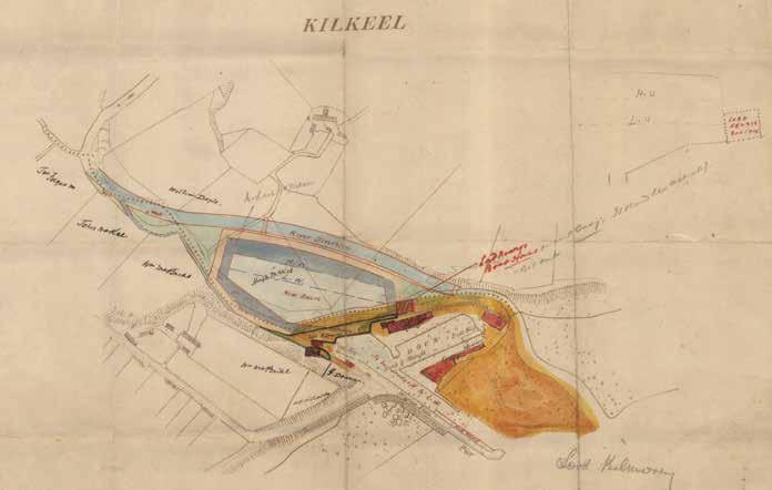
Map of Kilkeel Harbour, 1918
The Reside Collection at Newry and Mourne Museum

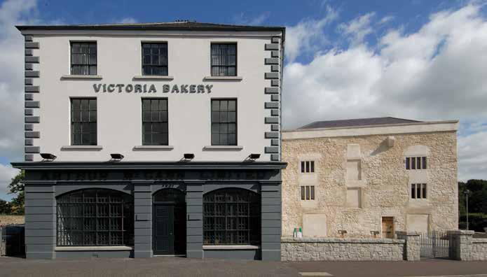
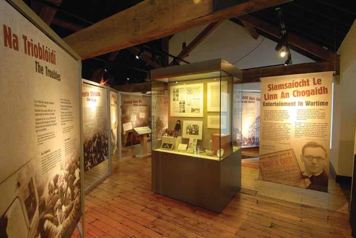
Newry and Mourne Museum is housed in a restored 16th-century fortified house and an attached 19th-century warehouse. Both structures were formerly used as a bakery and features from all periods of the history of the buildings have been integrated into the museum exhibition layout.
A major part of the exhibitions is devoted to exploring the impact of national and international political events on Newry and Mourne in the 20th century.
The permanent exhibitions trace the social and political history of the Newry and Mourne area from the prehistoric period to the early 21st century. Using a combination of interpretative panels and artefacts, the exhibitions provide an overview of the area’s history while giving an idea of the diverse material culture of the region.

Many of the artefacts highlight local achievements such as the ecclesiastical importance of the area, trade and industry and the region’s rich maritime heritage.
 Interactive exhibit in Newry and Mourne Museum which explores the history of Newry Canal
Albert Basin. Newry, c.1900
Interactive exhibit in Newry and Mourne Museum which explores the history of Newry Canal
Albert Basin. Newry, c.1900
All areas of Newry and Mourne Museum are accessible to wheelchair users and families with pushchairs and prams. A baby changing unit and Accessible Toilet are available on the ground floor.
2. Tourist Information
Newry Tourist Information Centre is located on the ground floor of the building and offers a comprehensive tourist information service. Tel. 028 30313170.
All Museum staff are trained in Health and Safety and a First Aid Officer is available during school visits.
Newry and Mourne District Council operates a Child Protection Policy and all staff are trained in its implementation.
5.
Although food and drink is not permitted in the Museum galleries it is possible for children to eat a packed lunch in the Banqueting Room. Newry and Mourne District Council operates a strict recycling policy.
This education resource pack is suitable for Key Stage 2 teachers and may also be of use to lower Key Stage 3.
This pack is divided into two sections:
1. A booklet which gives information on the maritime history of the Newry and Mourne area and Carlingford Lough.
2. Classroom activities focusing on five historical periods:
• Prehistoric Carlingford Lough
• Medieval people and the sea
• From monastic settlement to modern town
• Newry Canal
• The modern Port of Newry
This pack has 12 photocards each showing an image relating to an aspect of maritime history with a list of questions and suggested activities on the reverse.
The last Ice Age ended about 15,000 years ago and a warmer climate resulted in the melting of the vast ice sheets and the colonisation of land by plants and animals. The melting ice caused a rise in sea levels and by 9,000 years ago, Ireland had become separated from Britain by the Irish Sea.
The first humans to come to Ireland arrived from northern Britain during the Mesolithic period. Arriving in skin boats, they may have landed on the south Down or north Leinster coast, and spread from there to other parts of Ireland. These early settlers, known as “hunter-gatherers”, lived in coastal areas and survived on fish, shellfish and sea birds. Coastal areas also provided sources of flint from which they made simple tools. In the summer and autumn they migrated farther inland along river valleys to catch salmon and gather wild berries and nuts.

The Neolithic people were the next settlers in the Carlingford Lough region (approximately 6,000 years ago). These new settlers were the first farmers and lived in settled communities keeping domestic animals including cattle, sheep and pigs. Hunting was still important and the sea and rivers were significant sources of food. Pottery began to be produced and tools and weapons made from flint were traded throughout Ireland and abroad via boats. Due to the heavily wooded landscape, transport by water was essential.
Coastal settlement and interaction with the sea were important during the Bronze and Iron Ages. These periods saw the development of longer sea voyages and trading routes. Navigation was achieved using landmarks such as cliffs, mountains and headlands, and when voyages were made at night, by the moon and the stars. By the Iron Age, trading routes were developing between Ireland, Europe and the Mediterranean.
©
Reconstruction drawing of Mesolithic people gathering and eating oysters on the shoreline

© Northern Ireland Environment Agency
Separation from Britain meant that Ireland did not have a wide range of vegetation and wildlife making it a poorer country for the first human settlers. This situation created a greater reliance on the sea and rivers for food.
The most famous evidence of Neolithic settlement are megalithic tombs. There are a number of these burial places in the Carlingford Lough region. Some of these command good views of the sea, leading some archaeologists to believe that coastal areas were important in the religious beliefs of Neolithic people.
Ballykeel Dolmen, south Armagh Newry and Mourne Museum (photograph by Christina Joyce)1. Flint was used to make hunting implements and tools. Small pieces of worked flint were used to skin the hides of animals and prepare foodstuffs. Worked flints are found on archaeological sites, often in conjunction with animal bones which indicates previous human activity. You do not have to be an archaeologist to find these tools, they can often be found by walking over ploughed fields. Using Photocard 1 explore how these flints were made, how they compare to modern tools and what archaeology tells us about people in the past.
2. Look at Photocard 2 which illustrates foodstuffs eaten by prehistoric people.
Explore how these types of food would have been caught, collected, stored and prepared for eating. Blackberries and oysters would have been eaten raw, while other fish and animals such as eels and hares would have been cooked. In the Carlingford Lough area, middens of shells have been found, showing that shellfish were an important part of the diet of early man.
3. Boats were made from different materials in the Neolithic, Bronze Age and Iron Age. Look at the drawings of the boats and explore with the class what these boats were made from, how they were powered and how they were used.
Reconstruction drawings of boats
© Newry and Mourne Museum (artwork by Anna Savage) These drawings illustrate some of the boats that were used in prehistoric Ireland. They include boats made from animal skin, dugout canoes and plank boats.


The arrival of Christianity in Ireland in the 5th century AD introduced a new type of settlement into the Irish landscape – the monastery. Fish was an important part of the monastic diet and monks exploited the resources of local rivers and the sea.
The best documented early monastic site in the area is at Killevy, founded as a nunnery in the later 5th century by St. Moninne at the foot of Slieve Gullion.
As centres of wealth, learning and craftsmanship, Early Christian monasteries in coastal areas were an obvious focus for attack by the Vikings who first arrived in Ireland from Scandinavia in 795 AD. By the mid 9th century, they were establishing raiding camps – longphorts - to allow raiding parties to over-winter and raid farther inland.
The Carlingford region was a significant area of Viking activity. The Vikings gave Carlingford Lough its name, which reminded them of the fjords (sea inlets) of their homeland in Norway.
The 12th century witnessed extensive reform within the church in Ireland. One aspect of these changes was the introduction of the Cistercian monastic order. In 1153, twelve monks from Mellifont set up a Cistercian monastery at Newry under the patronage of Dermot O’Carroll, King of Oriel.
The estates of the abbey were organised into a system of granges or farms. The Clanrye river system with its tributary streams was utilised to provide power for corn mills and drainage for the monastic
buildings. Cistercian monks were originally vegetarian but they were eventually allowed to eat meat and fish on feast days. They would have used local water supplies to create artificial fish ponds, and fish weirs were established on the Clanrye River to catch salmon. Shellfish would also have been caught in Carlingford Lough.
The Anglo-Normans, who arrived in Ireland in the latter part of the 12th century recognised the strategic importance of Carlingford Lough. Large stone castles were built at Carlingford and Greencastle. A port grew up at Carlingford and this became an important link in medieval coastal communication routes and Irish Sea trade. A town also appears to have developed in Newry at this time, possibly at the gates leading to the abbey precinct.
Built c.1250
the
Castle at Carlingford on the opposite shore. A ferry connected the two castles and coastal trade with Dublin and other ports made them essential to Anglo-Norman military and economic control of the area.

1. Study the story of St. Patrick and find out where he came from and how he arrived in Ireland. Newry is traditionally associated with St. Patrick. Find out what other towns and places are associated with Ireland’s patron saint.
2. Explore the reasons why Carlingford Lough was attractive to the Vikings.
3. A monastic diet involved the eating of fish. The monks fished in the surrounding rivers, lakes and sea and built their own fishponds. Find out the different types of fish that would have been available.
©
Mourne
The early convent at Killevy was ideally located to make use of the fishing resources of Camlough. Its proximity to Carlingford Lough was useful for trade and communication, but made it an easy target for the Vikings who raided it in 923 AD.

Local tradition states that St. Patrick planted a yew tree on a hill overlooking the estuary of the Clanrye River - Iubhair Cinn Traghta (“the Yew tree at the head of the strand”), shortened to Na Iubhair and then to Newry. This legend is commemorated on the old town seal which features the abbot of the Cistercian monastery flanked on either side by a Yew tree. A Cistercian monastery was founded at Newry in 1153 possibly on the site of an earlier monastic settlement.

The area around Carlingford Lough is rich in Early Christian sites. A number of these were attacked by the Vikings who began raiding the coastal areas of Ireland from the later 8th century onwards. The Vikings subsequently settled at the foot of Slieve Foy (Carlingford) and established a raiding camp at Annagassan in 841 and another one at Narrow Water. They used Carlingford Lough as a base from which to raid further inland, particularly Armagh.
In 1534 Henry VIII became head of the English Church. One result of this was the dissolution of the monasteries in the 1540s, which had a major impact on landownership in the Carlingford Lough region.
The Cistercian abbey at Newry was dissolved and, in 1552, its estates, along with those of the Dominican Priory at Carlingford and the manor of Greencastle, were granted to Sir Nicholas Bagenal, an English settler from Staffordshire.
From the late 16th century to the 1690s the development of Newry was affected by the political and social uncertainty caused by the great changes in Irish society which followed the Flight of the Earls and the Plantation of Ulster.
In particular, the rebellion of 1641, Oliver Cromwell’s military campaign in Ireland and the Williamite and Jacobite Wars in which Newry was burned in 1689, ensured that town did not develop until the 18th century.
Landlords and merchants New landlords were again the determining factor in the development of Newry at the opening of the 18th century.
In the 1690s, Michael Hill purchased the townland of Carneyhough from the Crilley family and subsequently developed Trevor Hill. The Hill family developed the marshy area known as the Low Ground and laid it out as Hill Street.
Nicholas, the great grand son of Sir Nicholas Bagenal, died in 1712 and Newry passed to his cousin Robert Needham. Needham encouraged wealthy merchant families, such as the Corrys from County
Armagh, to settle in the town. Under the influence of Needham and Hill, Newry began to expand and a port developed. In 1726 the customs house was transferred to Newry from Carlingford, establishing Newry as the principal port in the area.
The building of Newry Canal, which started in 1731, also had a profound impact on the townscape. The old meandering course of the Clanrye River was straightened to flow alongside the canal and large warehouses began to appear along the quays. Maritime trade also influenced street names in Newry such as Merchant’s Quay and Sugar Island, which was named after the sugar imported from Robert Needham’s estates in the West Indies.
Map of “Carlingford Bay” from State of the Fortes in Ireland as they weare in the yeare 1624 by Nicholas Pynnar

B.L. Add. MS 24200 f.42 © British Library
A number of maps and surveys of the Irish coast and fortifications were produced in the late 16th and early 17th centuries. This map of Carlingford Lough is from a survey of military fortifications undertaken in 1624 by Captain Nicholas Pynnar who was surveyor and director general of forts in Ireland.
1.
2. Newry has always been centre of trade.What was produced locally and exported to other countries?
3. Arrange a walking tour of Newry. See if you can find an evidence of warehouses along Newry Canal. Take a camera and record what you see.
© The National Library of Ireland
Warehouses were built on both sides of the canal to store goods. Until 1956, boats were able to come up into the town, with the bridges being raised and lowered as required. After this date new fixed bridges replaced the older, swing bridges.


The strategic potential of Carlingford Lough and the “Gap of the North” was recognised in a grant of the lands of the former Cistercian abbey at Newry to Sir Nicolas Bagenal in 1552. He built a fortified house at Newry and set about re-developing the existing settlement. Documentary references to watermills on the Bagenal estate and fish weirs on the river, highlight the importance of local maritime resources to the economy of the 16th century town.
©
The Narrow Water area has a long history of occupation being a focus of settlement by the Vikings, Anglo-Normans and the military forces of Queen Elizabeth I who built the present castle in the 1560s. The castle commanded the narrow stretch of water at the head of Carlingford Lough and complemented Greencastle and King John’s Castle at Carlingford. The bawn around the castle included a small landing place for boats.
The Clanrye River flows through Newry. Why are many towns found close to rivers?
In the 18th century Newry was the premier trading port in Ulster surpassing Belfast and Derry with trading links to the West Indies, Newfoundland and the Baltic Sea.
The maritime importance of the town was enhanced by the completion of the Newry Canal in 1742, famous for being the first summit-level canal in the British Isles. It was primarily built to transport coal from Tyrone to Dublin as a means of reducing reliance on imports of costly coal from Britain. After an initial period of productivity, output declined and the coal mines closed down.
Work began on the canal in 1731 under the direction of Sir Edward Lovett Pearce and then of his deputy, Richard Cassels, and finally the engineer Thomas Steers. It traversed 18 miles of a lowland corridor between Down and Armagh to a height of 78 feet above sea level, necessitating the building of 15 locks to accommodate the changes in height.
With the inland section of the canal completed, attention was focused on trying to improve access from Newry to Carlingford Lough. Previously, boats had to negotiate the tidal, silt-choked Clanrye River between the sea and the quays.
In 1755 the Merchants of Newry petitioned Parliament for assistance in making the river navigable. The petition was successful, and the ship canal opened in 1767. Initial hopes were soon dashed, when silting reduced the draft from ten to five feet despite dredging of the canal.The only real improvement came with the building of a new ship canal between 1842 and 1850 and the completion of the Victoria Lock and Albert Basin, which accommodated seagoing vessels.
The most successful period of the canal was during the 1840’s when a variety of goods such as linen, butter, meat, coal, bricks and tiles were sent downstream to Newry, with a reverse traffic of grain, flour, flax seed, imported foodstuffs, whiskey, timber, oil and tobacco carried into midUlster. The canal remained an important transport artery until the arrival of the railways. The decline of the canal continued into the 20th century, and it was finally abandoned in 1949.
Detail of a map from The Antient and Present State of the County of Down by Walter Harris 1744, showing the original route followed by the Canal.
Shortly after the canal was built, Harris described the locks as ‘… 15 feet 6 inches wide, 44 feet long, … of an unequal depth according to the Situation of the Ground, some being 12., and others 13 feet deep .. faced with a hard gritty stone…. They are all boarded at the bottom with Deal Planks two inches thick. Some of them next to Newry are already pitched to render them stanch; and the rest intended to be so done’.
1. Explore the journey from Lough Neagh to Carlingford Lough. What towns and villages would you pass as you travel along the canal?
2. Find out what types of ships would have been used at this time and how they would have been powered.
3. Using Photocard 8 ask the class to find out what type of animals and plants are found along the canal. Maybe arrange a walking tour of the towpath.
©
This canal barge has large, shallow-screw propellers that were developed and patented by Henry Barcroft of Bessbrook. These could be fitted to an existing boat, and as they were underneath the stern, they did not interfere with the passage of barges through locks and bridges and could be used in shallow water.

Letter 10th October 1732
Newry and Mourne Museum Collection Written by the Lord Justice of County Armagh to the Lord Lieutenant of Ireland requesting the use of British foot soldiers ‘in making navigable a canal between Lough Neagh and Newry’. In addition to the labourers who dug the canal, it is also known that soldiers were involved in its construction.

Commercial success in Newry attracted investment in transport systems including improvements to the canals, and the first railway in the area which opened in 1849. This in turn helped local industries to expand further. Newry also became an important exit point for emigrants, particularly in the years after the Great Famine.
The improvements in infrastructure sparked a trading boom at the Albert Basin and local ship owning companies were established. One of the best known was Joseph Fisher and Sons Ltd, who became one of the most significant shipping owners on the Irish Sea.
Coal was by far the most important import carried by the ships, being a primary fuel for local industries and households. Exports were low compared to imports, and included cattle, timber, herrings, Mourne granite and potatoes.
In the first half of the 20th century Joseph Fisher and Sons Ltd were trading with most of the major ports in Britain and Ireland and the north coast of France. During the First and Second World Wars trade continued out of Newry, despite the risks from submarine and aerial attack. However, from the mid 1950s onwards, economic conditions and patterns in ship owning and trade became more competitive.
The port of Newry could not accommodate large ocean-going vessels and the decision was made to phase out Newry port and improve the port facilities at Warrenpoint. Joseph Fisher and Sons Ltd. was sold to Cawood Holdings in 1966. The ship canal was closed in 1974 and Newry’s trade transferred to the modern port of Warrenpoint. The ship canal has recently reopened to leisure boats, and ships now sail through the locks where they moor at the Albert Basin.
Smaller ports also developed along the coastline of southeast County Down. In the Mournes, Kilkeel and Annalong were important for exporting granite and for the fishing industry. Kilkeel was also a centre for boat building. On Carlingford Lough, Warrenpoint, Rostrevor and Omeath became popular holiday resorts.
Newry and Mourne Museum Collection
This poster advertises the sailing of the Lady Caroline from Warrenpoint to New Brunswick in Canada. Local merchants such as Francis Carvill also acted as emigration agents.


© William McAlpine
Warrenpoint, Rostrevor and Omeath, on the shores of Carlingford Lough, became popular holiday resorts. People from all over Ireland flocked to the seaside. Among the attractions were seabathing, skating and walking in the forest parks. This picture shows a boat which ferried visitors between Warrenpoint and Omeath.
1. Joseph Fisher and Sons Ltd and other shipping companies used flags to identify their ships and to send signals. Ask your class to use the internet to find out more about signal flags and get them to design their own individual flag.
2. From the late 19th century to the 1960s the Carlingford Lough area was a popular tourist destination. Explore the many attractions of the area. Discuss with the class what they expect to do on holiday today. Compare and contrast then and now.
3. Why do you think the Port of Newry declined in the 20th century?
Courtesy of John Matthews
The 1950s and 1960s saw large sea going vessels using the Port of Newry. Timber is pictured here being unloaded from a Scandinavian ship in the 1960s. The Port was still busy at this time but the limitations of the Newry Ship Canal meant that larger ships could not come to Newry and the docks closed in 1974.


Newry and Mourne Museum Collection
A port was constructed at Greenore on the north coast of County Louth in the 1860s to provide a link by sea with Heysham and Liverpool. The opening of the Dundalk, Newry and Greenore Railway in 1873 meant that Greenore became an important passenger terminus for people travelling to Britain. The Isle of Man became a popular holiday destination in the late 19th century.
First and foremost, thanks are due to current and former Gallery Attendants of Newry and Mourne Museum for their assistance in producing this booklet:
Fiona Byrne
Joanne Cummins
Emma Farrell
Conor Keenan
Shane McGivern
Maureen O’Connell-Fitzpatrick
Anna Savage
Dympna Tumilty
Thanks also to Sean Patterson for specialist information and to William McAlpine for supplying photographs. Christina Joyce and John Farrelly also provided photographs and artwork respectively. The McKeown family, John McParland, John Matthews and Brian Cassells allowed us to use photographs from their personal collections.
Text by Noreen Cunningham, Dr. Ken Abraham and Declan Carroll.
The Albert Basin in 1968

© William McAlpine
By the late 1960s large ocean-going ships found difficulty in accessing the port facilities at Newry. In January 1968, a number of vessels were trapped in the Albert Basin for several weeks after the MV Saint William crashed into the Victoria Locks, damaging the gates.
Early 20th century souvenir teapot showing Annalong Corn Mill, County Down Newry and Mourne Museum Collection Annalong Corn Mill was built in the 1800s and operated until the 1960s as one of the last working mills in Northern Ireland. It is located beside Annalong Harbour which was constructed in the mid 19th century. Mourne granite and potatoes were exported from here to Britain.