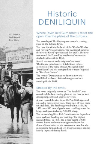
Historic DENILIQUIN 1917 flood at the Edward River Hotel
Where River Red Gum forests meet the open Riverine plains of the outback... The township of Deniliquin grew around a crossing place on the Edward River. The river lies within the lands of the Wamba Wamba and Perrepa Perrepa Nations. The traditional name for the river is ‘Kolety’ (pronounced ‘kol-etch’). The river was named the Edward by ‘overlanders’ en-route to Adelaide with cattle in 1840. Several versions as to the origins of the name ‘Deniliquin’ exist, however it is believed to be a corruption of the name of local Aboriginal Elder ‘Denilakoon’ and was thought then to mean ‘big man’ or ‘Wrestler’s Ground’. The town of Deniliquin as we know it now was established in about 1846 and was gazetted as a municipality in 1868.
Shaped by the river... The town, originally known as ‘The Sandhills’, was considered the best crossing place on the river by local Aboriginal people and later by surveyors. A punt crossed the river from 1847 to 1861, operated on a cable between two trees. Three bales of wool made up a full load. The first bridge was built in 1864. By 1871, over 900 tons of goods were travelling across the bridge each year, including 525,050 sheep. The surrounding River Red Gum forests are dependent upon cycles of flooding and draining. The highest recorded flood, in 1870, had a peak height of 9.68 metres. Levees and water management lessen the threat of inundation on the town centre now, but the surrounding farmland and low-lying businesses are still heavily impacted during floods. FROM THE COLLECTIONS OF THE STATE LIBRARY OF NEW SOUTH WALES
4


