SIACHEN
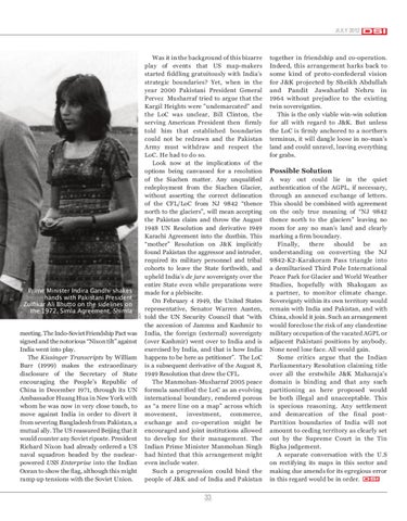
Prime Minister Indira Gandhi shakes hands with Pakistani President Zulfikar Ali Bhutto on the sidelines on the 1972, Simla Agreement, Shimla
conference of serving and retired Defence officials in Delhi in 1991, that the Indian Army had taken “a keen interest” in his time at the “how, when and why” USDMA had taken on itself the task of border delimitation in this sector. The only answer vouchsafed was that the process had commenced in 1967. No other records were apparently available with the US. However, on March 12, 1987, the Office of the Geographer of the U.S State Department issued guidelines to producers of official US maps that admitted past inconsistencies and specifically instructed them not to extend the line beyond NJ 9842 to the Karakoram Pass. Nonetheless, the damage had been done and remains uncorrected, with no apologies by or to anybody to this date.
32
Siachen 3rd time.indd 5-6
If innocent absent mindedness on the part of one or more official US agencies is not altogether convincing, where else might one look, howsoever tangentially, for possible explanations of the Siachen muddle? The Sino-Soviet rift was out in the open and the US, having extricated itself from the IndoChina quagmire, had begun to review its relations with the People’s Republic of China, now a nuclear power. The Sino-Pakistan rapprochement post-1963 made Pakistan a critical conduit to quiet Sino-US talks. Henry Kissinger, as the American Secretary of State famously headed to the Subcontinent to stave off the possibility of an Indo-Pakistan war on account of the Bangladesh liberation struggle, a mission famously overshadowed by his secret dash to Beijing from Islamabad and the ensuing announcement of a Mao-Nixon
meeting. The Indo-Soviet Friendship Pact was signed and the notorious “Nixon tilt” against India went into play. The Kissinger Transcripts by William Burr (1999) makes the extraordinary disclosure of the Secretary of State encouraging the People’s Republic of China in December 1971, through its UN Ambassador Huang Hua in New York with whom he was now in very close touch, to move against India in order to divert it from severing Bangladesh from Pakistan, a mutual ally. The US reassured Beijing that it would counter any Soviet riposte. President Richard Nixon had already ordered a US naval squadron headed by the nuclearpowered USS Enterprise into the Indian Ocean to show the flag, although this might ramp up tensions with the Soviet Union.
AFP
it would have been natural and simple to apologise and make amends in an appropriate manner. Nothing of the kind happened. Nor did the Indian Government respond to any of these alarm bells. Robert G. Wirsing, the American scholar, later dwelt on this issue at some length in, India, Pakistan and the Kashmir Dispute: On Regional Conflict and Its Resolution (Rupa 1994). He writes: “By the early 1980s, practically all the most respected atlases … were showing the CFL/LoC extending beyond grid reference point NJ 9842, about 55 miles in a clear north-easterly direction all the way to the Karakoram Pass on the Chinese border. The extension was a distinct departure from past cartographic practice. The UN maps of Kashmir produced in the early years of the dispute all terminated at the map coordinate NJ 9842. In India and Pakistan, display of the CFL or LoC on publicly sold maps has been officially discouraged at least since the 1965 war; but among the scores of pre1965 official or officially-approved maps surveyed by this author in the Library of Congress, not a single one showed any extension beyond NJ 9842. Wirsing also notes, “A nearly universal shift by map-makers to an extended and eastward-running CFL/LoC (from NJ 9842 to the Karakoram Pass) was eventually achieved...One can hardly escape the conclusion that the US Defence Mapping Agency, one of the largest and probably the most influential of international mapmakers, played a far from inconsequential role in the world’s “cartographic award of Siachen to Pakistan”. Astonishingly, there was during all of this period no known formal protest from the Government of India or any of its agencies even as others cheerfully played ducks and drakes with one of India’s most sensitive borders. This undermined the solemnly certified UN-authenticated CFL. India was placed at a huge political and military disadvantage in J&K through a cartographic sleight of hand that gratuitously rewarded Pakistan. According to Wirsing, however, Lt. Gen M.N. Kaul, former Northern Army Commander in the late 1970s, had said at a
JULY 2012
Was it in the background of this bizarre play of events that US map-makers started fiddling gratuitously with India’s strategic boundaries? Yet, when in the year 2000 Pakistani President General Pervez Musharraf tried to argue that the Kargil Heights were "undemarcated" and the LoC was unclear, Bill Clinton, the serving American President then firmly told him that established boundaries could not be redrawn and the Pakistan Army must withdraw and respect the LoC. He had to do so. Look now at the implications of the options being canvassed for a resolution of the Siachen matter. Any unqualified redeployment from the Siachen Glacier, without asserting the correct delineation of the CFL/LoC from NJ 9842 “thence north to the glaciers”, will mean accepting the Pakistan claim and throw the August 1948 UN Resolution and derivative 1949 Karachi Agreement into the dustbin. This “mother” Resolution on J&K implicitly found Pakistan the aggressor and intruder, required its military personnel and tribal cohorts to leave the State forthwith, and upheld India’s de jure sovereignty over the entire State even while preparations were made for a plebiscite. On February 4 1949, the United States representative, Senator Warren Austen, told the UN Security Council that “with the accession of Jammu and Kashmir to India, the foreign (external) sovereignty (over Kashmir) went over to India and is exercised by India, and that is how India happens to be here as petitioner”. The LoC is a subsequent derivative of the August 8, 1949 Resolution that drew the CFL. The Manmohan-Musharraf 2005 peace formula sanctified the LoC as an evolving international boundary, rendered porous as “a mere line on a map” across which movement, investment, commerce, exchange and co-operation might be encouraged and joint institutions allowed to develop for their management. The Indian Prime Minister Manmohan Singh had hinted that this arrangement might even include water. Such a progression could bind the people of J&K and of India and Pakistan
DSI
together in friendship and co-operation. Indeed, this arrangement harks back to some kind of proto-confederal vision for J&K projected by Sheikh Abdullah and Pandit Jawaharlal Nehru in 1964 without prejudice to the existing twin sovereignties. This is the only viable win-win solution for all with regard to J&K. But unless the LoC is firmly anchored to a northern terminus, it will dangle loose in no-man’s land and could unravel, leaving everything for grabs.
Possible Solution A way out could lie in the quiet authentication of the AGPL, if necessary, through an annexed exchange of letters. This should be combined with agreement on the only true meaning of “NJ 9842 thence north to the glaciers” leaving no room for any no man’s land and clearly marking a firm boundary. Finally, there should be an understanding on converting the NJ 9842-K2-Karakoram Pass triangle into a demiltarised Third Pole International Peace Park for Glacier and World Weather Studies, hopefully with Shaksgam as a partner, to monitor climate change. Sovereignty within its own territory would remain with India and Pakistan, and with China, should it join. Such an arrangement would foreclose the risk of any clandestine military occupation of the vacated AGPL or adjacent Pakistani positions by anybody. None need lose face. All would gain. Some critics argue that the Indian Parliamentary Resolution claiming title over all the erstwhile J&K Maharaja’s domain is binding and that any such partitioning as here proposed would be both illegal and unacceptable. This is specious reasoning. Any settlement and demarcation of the final postPartition boundaries of India will not amount to ceding territory as clearly set out by the Supreme Court in the Tin Bigha judgement. A separate conversation with the U.S on rectifying its maps in this sector and making due amends for its egregious error in this regard would be in order. DSI
33
20/07/12 5:29 PM