
Mr. Jeff Ronaldson
Will County Department of Transportation
16841 W. Laraway Road
Joliet, Illinois 60433
RE: Eastern Will County Freight Mobility Corridor Study: Village of Monee Development and Infrastructure Projects
Dr. Therese Bogs
Mayor
Michelle Powell-Johnson Clerk
Trustees:
Michael Wilson
Doug Horne
John Henson
Scott Youdris
Heidi Gonzalez
Chuck Rakis
Ruben Bautista
Dear Mr. Ronaldson,
Thank you for taking the time to discuss the Village of Monee’s concerns regarding the upcoming Will County Department of Transportation Eastern Will County Freight Mobility Corridor Study. As discussed, the Village has worked very hard to create a long-term vision for the Village of Monee. The proposed alternatives will potentially have a devastating impact on planned future developments within our Village. Please find below a summary of current and planned developments within the Village that have a potential to be impacted by alternatives for your planning purposes below. A location map has been attached for your reference.
1. Towne Center Commercial Development
o The Towne Center Commercial Development is located on approximately 38 acres bound by Monee-Manhattan Road to the north, Governors Highway to the east, Wilson Street to the south, and Egyptian Trail to the west.
o Tractor Supply Company has begun construction of a new store on the southwest corner of Governors Highway and Monee-Manhattan Road. A detention pond with decorative landscaping on the southwest corner of the Monee-Manhattan and Governors Highway intersection is proposed as well.
o Construction has begun on Bailly lane which will provide full access to Governors Highway via Towne Center Way and right-in/right-out access onto Monee-Manhattan Road. The right-in-right out access was approved and permitted by Will County DOT, yet it appears it may conflict with the potential Governors Highway overpass.
o Future plans for the site include a grocery store and several other additional commercial properties. Please see Exhibit B for the preliminary land plan. Our concern is the Crete-Monee North Alternative will decrease accessibility and visibility of commercial developments in the Towne Center and prevent further development of the site.
2. Village Square Development
o ±15-acre commercial development at the northwest corner of Egyptian Trail and Monee-Manhattan Road.
Administrator
Scott Koerner
Police Chief
Randy Ulaskas
Emergency Mgmt. Agency
Ed Johnson Public Works
Judith Knabe Human Resources
Darryl Bulliner Finance Director
Bill Barnes
Economic Development
Dianna Kroll
Parks & Recreation
Village Hall
25711 S. Egyptian Trail
708-534-8301
Parks & Recreation
5130 W. Court St.
708-534-8302
Building Services
708-534-8303
Economic Development
708-534-8304
Public Works
708-534-8306
708-534-1040 fax
Emergency Mgmt.
708-534-8305
Police Department
5357 W. Main St
708-534-8308 records
o A preliminary land plan has been prepared for this development and the Village is in discussions with a commercial developer. Please see Exhibit B for the preliminary land plan.
o The Village is in the process of purchasing and demolishing residential properties as the first phase of this development
3. 90 Acre Development east of Egyptian Trail/Governors Highway and north of Watson Cutoff
a. The 90 acre property east of Egyptian Trail south of the Walkers Grove residential subdivision has been purchased by the Village. The proposed Crete-Monee South Alternative runs east-west through the middle of this property from Governors Highway to Will-Center Road.
b. Design has begun for a new Police Station on this site.
c. Additionally, a developer is interested in placing a residential development within the area of the property not being planned for the Police Station. Please see Exhibit C for the preliminary land plan.
d. The preference of the Village is this property be developed into a residential subdivision since it sits between two existing residential subdivisions. A truck route through any portion of this property would reduce the potential size of the development, make it difficult to attract residential home buyers, and reduce the quality of life of the existing adjacent residents to the north and south.
4. 77 Acres south of the Eagle Fair Estates and west of Will-Center Road
a. Discussions between the Village and a developer are ongoing for a potential 77 acre multi-family residential development and senior living facility.
5. Bormet Property
a. Negotiations are ongoing with the property owner to acquire the 155 acre property at the southeast corner of Will-Center Road and Crete-Monee Road.
b. The first alternative is for the property to be developed into a sportsplex. The proposed routing of the Crete-Monee South Alternative through this property would limit its desirability and ability to develop into a sports complex.
c. If a sportsplex is unfeasible, the property will be developed into a residential subdivision. Again, a truck route through any portion of this property would reduce the potential size of the development, make it difficult to attract residential home buyers, and reduce the quality of life of the existing adjacent residents to the west.
6. Industrial Drive and Cleveland Avenue Area
a. A new public works facility is being constructed on the south side of Industrial Drive.
b. An additional Municipal Development on the south side of Industrial Drive is being planned.
c. Significant investments have been made to relieve truck traffic on Monee-Manhattan Road from Cleveland Avenue to Governors Highway.
i. Industrial Drive is currently being reconstructed as 3-lane roadway with curb and gutter and should be completed this construction season.
The Village has received funding to realign Cleveland Avenue with Hamilton Avenue and install a traffic signal at the intersection with Monee-Manhattan Road.
Phase II Engineering funding has been programmed in Federal Fiscal Year 2026 for the Cleveland Avenue Reconstruction Project. This project will reconstruct Cleveland Avenue from Industrial Drive to Monee-Manhattan Road.
7. Safe Routes to Schools
a. The Village has recently completed a Safe Routes to Schools Project to install sidewalk along Court Street and Will-Center Road to provide a safe pedestrian connection for students to the MoneeElementary School from the Village sidewalk network. The Crete-Monee North Alternative proposes to cross the Safe Routes to Schools sidewalk, adding a major roadway for students to cross while going to and from school. The Village is continually investing in safety enhancing pedestrian projects for our residents. It is important that any alternative that is carried forward aligns with the Village’s goal to provide safe pedestrian routes throughout the Village.
b. Engineering is in process for a new sidewalk along Will-Center Road from Margaret Street to Court Street to provide a pedestrian route for children from the southern areas of the Village to the Monee Elementary School.
8. Crete-Monee Road Resurfacing
a. STP funding to resurface Crete-Monee Road from Will-Center Road to Steger-Monee Road programmed in 2027.
9. Northern Builders Development on Ridgeland Avenue
a. Approximately 37-acre site for future industrial/commercial development
10. 57-Acre industrial development north of Monee-Manhattan Road across from Amazon
a. Discussions are ongoing between the Village and a developer for an approximate 57 acre industrial/commercial development.
11. Voortman Steel
a. Voortman Steel is currently constructing their North American Headquarters on an approximately 27-acre property on the east side of Ridgeland Avenue.
The proposed alternatives pose a direct threat to Monee's established and planned residential areas, necessitating other viable alternatives to divert commercial vehicle traffic. Furthermore, numerous ongoing and future commercial developments, notably the Towne Center, face significant risk from reduced visibility and access, severely limiting our growth potential. Since the recent public meeting, our Mayor's Office has been overwhelmed by community opposition via every channel email, voicemail, in-person visits, Board Meetings, and social media underscoring the deep impact on our citizens and businesses. As requested by our residents, the Village will forward signed petitions and attestations to your office, providing a unified voice of profound concern. We urge your immediate attention and look forward to collaborative dialogue for a viable solution.
Respectfully submitted,

Ruben Bautista Administrator Village of Monee
Encl:
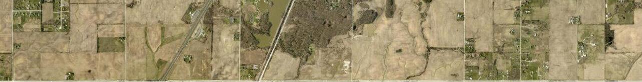
Exhibit A – Development Project Location Map
Exhibit B – Town Center and Town Square Land Plan
Exhibit C – 90 Acres Police Station and Residential Subdivision Land Plan