

POPS
Privately Owned Public Space
Vadlamudi Akhil Akash Columbia University in the City of New York
This publication is made possible by the support of faculty Jonathan Stiles from Graduate School of Architecture, Planning and Preservation at Columbia University in the City of New York.
Copyright@2023 by Vadlamudi Akhil Akash.
All Illustrations and layouts © 2023 by Vadlamudi Akhil Akash ™.
All Photographs © 2023
All rights reserved ™

POPS
Privately Owned Public Space
Vadlamudi Akhil Akash Columbia University in the City of New York
This book is a result of work output produced in the Geographic Information System (GIS) class during my Urban Planning Coursework at Columbia University, the work is a close representation of all the techniques learnt in the class and are a direct application of the class work, during this process, I learnt data cleaning, data processing and visual representation of geographic information that helps to propose various urban planning solutions in the due course of my planning journey.
During my course work, I became fascinated with the works of William H Whyte in the book “The Social Life of Small Urban Spaces”. that summarises the research undertaken as part of street life project for New York City Planning Commission . This is a phenomenal work on the urban spaces in New York City. and in my curious research found that the City of New York allowed developers to build as of right buildings while granting for additional floor space in exchange for publicly accessible open space, this concept is something that I wished to explore through GIS, my main question is where are the future POPS (Privately Owned Public Space) needed and possible. Thus we have a good documentation of all the social and demographic aspects of New York City to look at sites that can take in new POPS
Privately Owned Public Spaces
Privately Owned Public Spaces (POPS) are public spaces that are privately owned and maintained by developers in exchange for zoning concessions from the city. They are a result of City zoning regulations aimed at ensuring the densest areas of our city offer a measure of open public space and greenery. More than 590 POPS provide a myriad of opportunities to sit, relax, people watch, eat, meet others, and enjoy the city life . POPS come in many shapes and sizes, both outdoor and indoor, and offer a variety of amenities such as seating, tables, public art, and more1. They are important amenities for New Yorkers, commuters, and visitors alike2.

The POPS program was inaugurated in 1961 with the 1961 Zoning Resolution, which encouraged private developers to provide publicly accessible spaces, specifically plazas and arcades, on private property in exchange
1 https://apops.mas.org/find-a-pops/
2 https://www.nyc.gov/site/planning/plans/ pops/pops.page
for bonus floor area in certain high-density districts. It was one of the earliest forms of “incentive zoning” . To date, over 590 POPS have been built at over 380 buildings across New York City. These public spaces are primarily located in Manhattan, but are increasingly being developed in the other boroughs, particularly Brooklyn and Queens, as the commercial office markets expand.3
APOPS, a joint project of the Municipal Art Society of New York (MAS) and the New York City Department of City Planning, has created an interactive map of privately owned public spaces (POPS) in New York City. This map provides detailed information about each POPS, including its location, amenities, and hours of operation.
3 https://www.nyc.gov/site/planning/plans/ pops/pops-history.page
Open Space

Accessible
Guidelines of POPS
The open space design is characterized by its transparent accessibility to the public, ensuring visibility and comprehension. The layout maintains an unobstructed view through judiciously placed design elements and expansive pathways leading seamlessly into the plaza. Adjacent to the public sidewalk, the area incorporates thoughtfully positioned seating and amenities.
The plaza is strategically situated at the same elevation as the sidewalk, optimizing pedestrian circulation and facilitating easy access. This design choice enhances the overall accessibility of the space, fostering a welcoming environment for all.
Safe and Secure
Comfortable and engaging
A key focus of the design is safety and security, achieved through easily navigable paths for both entry and exit. The orientation of the plaza is deliberately aligned with visual connections to the surrounding street, promoting a sense of security. Adequate lighting within the plaza and along the connecting sidewalks further contributes to a safe and well-lit environment.
To encourage usage and comfort, the plaza is equipped with essential amenities catering to the needs of individuals and small groups alike. Diverse, well-designed seating options are strategically placed to accommodate different preferences. The design strikes a harmonious balance between open spaces and greenery, integrating trees to enhance the overall comfort and aesthetic appeal of the public area.
Year Completed
The majority of Privately Owned Public Spaces (POPS) are concentrated in East Midtown and Lower Manhattan, reflecting a high-density, mixed-use urban environments.
The most recently developed POPS in New York City is located at 525 Eighth Avenue, completed in 2019, demonstrating the continued evolution of urban public realm integration.
Conversely, the earliest recorded POPS, as per the dataset, was completed in 1963 at 777 Third Avenue.
Hours of Operation

New POPS
By definition, Privately Owned Public Spaces (POPS) are intended to remain accessible 24/7, as they serve as public amenities. Among the total POPS in New York City, 250 operate continuously, ensuring round-the-clock access.
However, a subset of 54 POPS operates under restricted hours, locations such as Trump Plaza and Park Avenue Plaza, impose limitations on public accessibility.
Additionally, some POPS are temporarily closed for specific events or private functions.
Notable examples include The Harmony Atrium (David Rubenstein Atrium), Trump Tower, and the Museum of Modern Art, which occasionally restrict public access due to programmed activities or institutional needs.

Currently, four new Privately Owned Public Spaces (POPS) are under construction in Manhattan, located at Park Place, Madison Avenue, Park Avenue, and Broadway. These additions will further enhance the inventory of POPS, bringing the total number to 366 within Manhattan.
This ongoing development shows potential real estate interest and land dynamics to integrating accessible public spaces within the dense urban fabric, contributing to the livability and spatial equity of the cityscape.
Research Question Methodology
Find a suitable location for POPS, where it most needed as allowed
Has POPS increased access to Public Open Spaces in Manhattan?
Data Sources
Data Processed
Pre Analysis
Data Sources
Federal Emergency Management Agency -
Community Resilience Challenges Index
NYC Roads-
Office of Technology and Innovation (OTI)
NYC POPS -
Department of City Planning (DCP)
Map Pluto -
NYC Department of City Planning,
Information Technology Division
NYC Parks -
Department of Parks and Recreation (DPR)
DNSY Districts-
Department of Sanitation (DSNY)
Federal Emergency Management Agency
Community Resilience Challenge Index
American Community Survey
NYC Roads
Housing Units Occupied by Owners
Households without vehicles
Population with a disability
Population Density
Population over 65 years of Age
Road Centerlines
Rasterise and reclassify
Network database
Results
NYC POPS Map Pluto
POPS Statistics
Construction Status of POPS
Hours of Operation
Year of Completion
Network Analysis
Rasterise
Service area analysis
Closest facility
Service area of POPS
Building Density
Year Built
Percent Population with Disability
Income Inequality
Low Median Income
Owner Occupied Units
No Vehicle Ownership
65+ years of Age
Land Use
Building Density
Land Suitability for POPS
Building foot print
Point Density
Reclassify
Network Analysis
Service area analysis
Closest facility
Summarise within
Accessibility to POPS
NYC Parks
NYC Parks
Summarise within Rasterise
Housing Units Occupied by Owners
Demographics

Demographics for proposal of New POPS
Housing Units Occupied by Owners
Households without vehicles
Population with a disability
Population Density
Population over 65 years of age
Building Density
POPS Density
Buffer from existing POPS
It is often observed that renters are accommodated in compact living spaces, primarily driven by property owners’ intent to maximize profits. Neighborhoods such as Washington Heights, Clinton, East Harlem, and the Lower East Side exhibit the highest concentration of renters. A potential intervention could focus on ensuring equitable access to open spaces for these renters, fostering improved quality of life in high-density residential areas.
Conversely, the areas adjoining Central Park are predominantly inhabited by homeowners who have chosen to settle there, drawn by the unparalleled opportunity to enjoy views of a vast, open park situated amidst the dense urban environment. This dynamic illustrates the varying degrees of access to open space, influenced by residential patterns and housing tenure.

Population with a Disability Households without Vehicles
New York City is renowned for its robust public transportation system, with the subway operating 24/7 and providing comprehensive coverage. As a result, Manhattan demonstrates a lower prevalence of vehicle ownership compared to other regions, reflecting the effectiveness of its transitoriented infrastructure.
Owning a vehicle can enhance mobility and access to better open spaces; however, strategically locating POPS in areas with limited private vehicle access can significantly improve residents’ overall quality of life by fostering equitable access to recreational and communal amenities.
For many, vehicle ownership is tied to job accessibility, yet Manhattan’s exceptional transit network reduces the necessity for private vehicles. This is particularly evident in neighborhoods such as Clinton and Central Midtown, where a higher share of households without vehicles suggests proximity to employment hubs and the availability of convenient public transit options.

A larger population of individuals with disabilities resides in Eastern Harlem, Washington Heights, and the Lower East Side. Consequently, there exists a demand for enhanced accessibility in public spaces to accommodate their unique needs.
Populations with disability may sometimes have access to open spaces that are ADA compliant, certain parks like Morning-side heights are difficult for people with disability to access without active support.
It would be especially difficult to make all the parks ADA compliant, especially parks with a challenging topography.
Population Density

Population over 65 years of Age
Manhattan experiences a significant concentration of population density, with notable clusters observed in areas such as Central Park and Harlem, reflecting the urban core’s dynamic and high-density character.
Open spaces play a crucial role in alleviating urban congestion. Beyond their potential health benefits, these spaces foster social cohesion and provide essential opportunities for community interaction, contributing to the overall well-being of residents in densely populated areas.

A substantial segment of the elderly population resides in Lower Manhattan, where there is a clear demand for accessible and welldesigned open spaces to cater to their mobility and recreational needs.
While many older residents have settled near Central Park, enjoying the benefits of a vast green space, this privilege is not universally available. For retirees living in urban environments, the provision of thoughtfully planned open spaces becomes essential to promote physical well-being, social engagement, and an enhanced quality of life during their later years.
POPS Density

Buffer from existing POPS
The majority of Privately Owned Public Spaces (POPS) are concentrated in East Midtown and Lower Manhattan, reflecting the strategic alignment of these areas with high-density development and commercial zoning.
This concentration can likely be attributed to the rezoning efforts in Midtown Manhattan, which have incentivized the creation of POPS as part of the broader urban development strategy, aimed at enhancing public access and improving the public realm in a densely built environment.
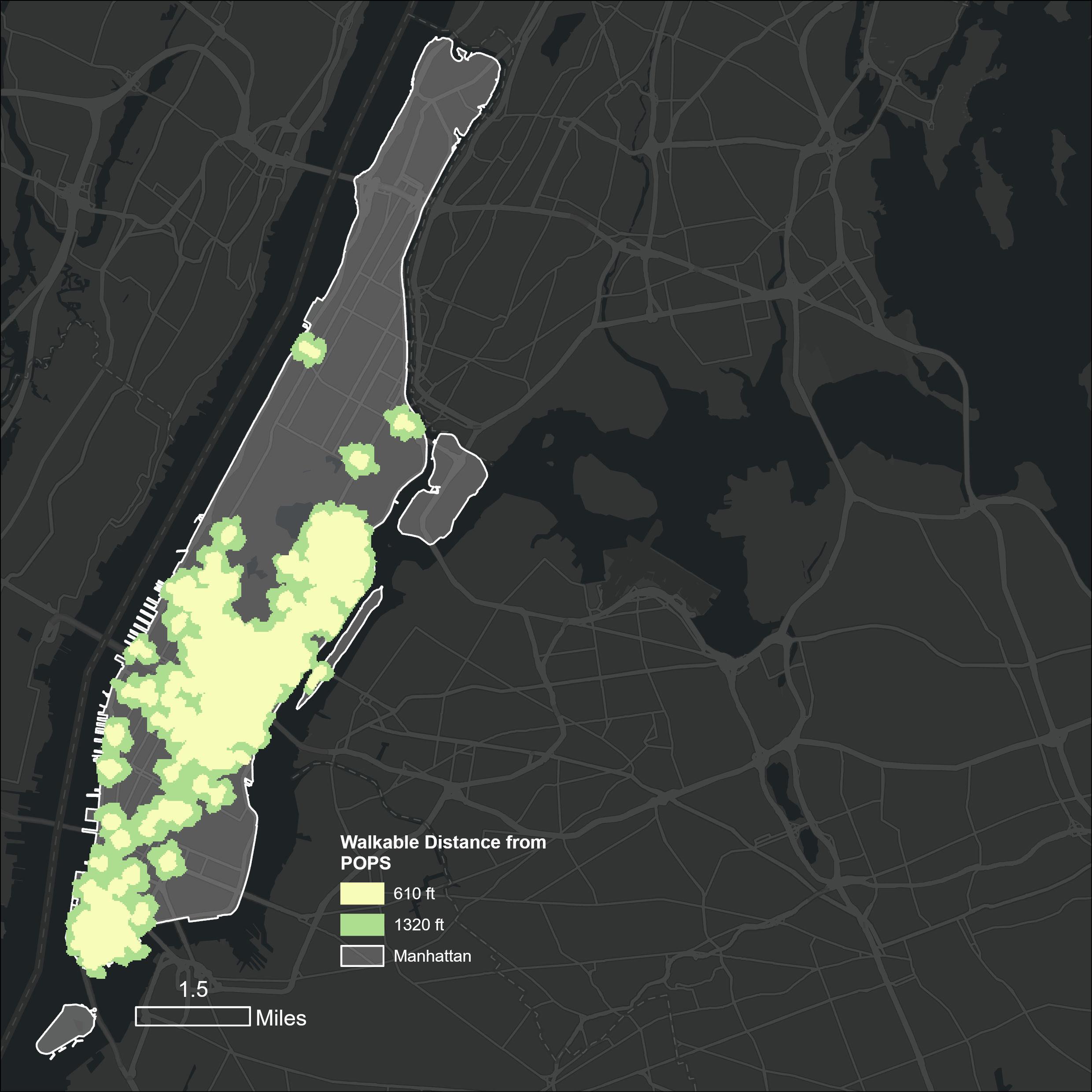
A buffer zone of 610 feet has been established around existing POPS to ensure optimal spatial distribution across the city. This buffer serves as a planning mechanism to prevent clustering and promote equitable access to public space.
Building Density

Multi Criteria Decision Analysis (MCDA)
Elevated building density is particularly evident in Lower Manhattan, the Upper East Side, the Upper West Side, and Central Harlem, where the urban landscape is marked by a concentration of high-rise developments and mixed-use buildings.
Building density often indicates smaller plot sizes, which can accommodate more structures and, consequently, more residents or businesses. Denser developments are seen as a more efficient use of limited land resources, optimizing urban space in a city with constrained real estate.
In this context, Privately Owned Public Spaces (POPS) play a critical role in providing essential open space, offering a counterbalance to the intense land market in New York City and contributing to the overall livability of highly developed neighborhoods.
Identify the ideal places for future development of POPS
610ft Park Buffer Service area of POPS
Building Density Year Built
Percent Population with Disability Income Inequality
Percent Population with Low Median Income Percent with Owner Occupied units Percent Population without Vehicle
Percent Population of age 65 years and above Land Use Population Density


Multi-Criteria Decision Analysis (MCDA)
The multi-criteria decision analysis highlights the potential for proposing new POPS west of Columbia University, near Riverside Church. While Morning-side Heights benefits from proximity to public parks such as Riverside and Morning-side Parks, these spaces often lack comprehensive accessibility for individuals with disabilities, creating a gap in equitable open space access.
Additional opportunities for POPS development are identified in the East Village, near the East River and Williamsburg Bridge, where enhanced accessibility could address local needs. Furthermore, a large parking lot located at West 24th Street and 11th Avenue represents a significant missed opportunity to transform underutilized land into an inclusive and accessible open space.
In Washington Heights, the analysis indicates potential for a new POPS south of New YorkPresbyterian Hospital, which could cater to the surrounding community while enhancing access to open space in the area.
Network Analysis

Identify if the existing POPS have increased the accessibility to Open Spaces
Unit of Analysis
Parks of Manhattan
Accessibility to Parks
Accessibility to POPS
Accessibility to POPS and Parks
Parks in Manhattan

Accessibility to Parks
New York City encompasses over 30,000 acres of parkland, constituting approximately 14% of its total land area. These spaces are vital for urban sustainability and community well-being, yet their aging infrastructure presents significant challenges.

Accessibility to parks in Manhattan reveals notable disparities, particularly when comparing neighborhoods like the Upper East Side and Washington Heights to the regional accessibility offered by Central Park. These differences emphasise the varying degrees of proximity and access to green spaces across the borough.
With minimum accessible distances of 725 feet and maximum distances extending to 2,244 feet—all within a half-mile radius—the data suggests that Manhattan generally maintains better-than-average accessibility to parks.
Accessibility to POPS

Accessibility to POPS and Parks
The distribution of Privately Owned Public Spaces (POPS) in Manhattan reveals significant spatial disparities. While the majority are concentrated in the Lower East Side, northern neighborhoods like Washington Heights lack access, with residents required to travel approximately 11,882 feet (2.25 miles) to reach the nearest POPS. Interestingly, even within the Lower East Side, accessibility to POPS is limited, with average distances ranging from 3,660 feet to 5,887 feet.
Additionally, the Lower East Side faces challenges related to transit accessibility.
The area lacks sufficient proximity to subway stations, leaving residents heavily reliant on bus services, further compounding the accessibility issues for those seeking equitable access to POPS and other urban amenities.

The majority of Privately Owned Public Spaces (POPS) are concentrated in East Midtown and Lower Manhattan, reflecting their alignment with high-density commercial and residential zones. However, Washington Heights emerges as a neighborhood with notably limited access to open spaces, highlighting a critical gap in spatial equity.
While the Upper West Side and Upper East Side benefit from proximity to Central Park, they lack sufficient smaller neighborhood parks, which are essential for meeting local community needs. Conversely, East Harlem, despite its strong access to parks, faces significant public health challenges, including the highest asthma rates in the nation, underscoring the need for a combined approach to urban planning that integrates environmental and health considerations.
Accessibility

While accessible distance refers to physical proximity, it does not necessarily equate to true accessibility for individuals with diverse abilities. Not all parks are designed to accommodate people with different mobility needs, creating barriers to equitable access.
Addressing these challenges across large parks would require significant time and resources. In contrast, smaller open spaces like POPS can serve as a more immediate and cost-effective solution, providing accessible public spaces that meet the diverse needs of all city residents.
Limitations
Conclusion
Results
Recommendations
Limitations Conclusion
The Central Park is taken as a point for network analysis besides this it is assumed that the park aims to be a regional park for regional purposes and the study focuses on access to parks at neighborhood level.
The established walking distance of 610 feet is grounded in thoughtful considerations:
1. Catering to Vulnerable populations: Recognizing the potential challenges faced by the elderly and disabled, the 610 feet radius
addresses the concerns related to mobility limitations, ensuring that a quarter mile walk does not pose undue difficulty.
2. Facilitating Access for Children:
Acknowledging the unique needs of children, the shorter walking distance optimizes accessibility to open areas, fostering an environment where younger residents can easily and safely access recreational spaces.
Limitations Acknowledgment: Acknowledging the limitations of the current accessibility analysis is crucial. While Central Park serves as a valuable reference, additional variables must be explored to capture the full spectrum of factors influencing POPS development.
Private Interface Transformation: The intrusion of private interfaces has substantially altered the essence of POPS, raising pertinent questions about the socio-economic motivations underpinning their development. A comprehensive exploration of these aspects is essential for informed future planning.
Recommendations
Results
Disparity Range: The observed range in accessibility, spanning from 567 to 1,203 feet, signals a significant discrepancy in the distribution of POPS across different neighborhoods. This underscores the need for targeted interventions to address disparities and enhance equitable access to public spaces.
Urban Impact: POPS have not only altered the accessibility landscape but have also played a transformative role in shaping the urban environment. The impact of POPS on the social and economic dynamics of specific districts requires careful consideration in future planning endeavors.
Zone-Based Incentives: Proposing the introduction of zone-based incentives as a strategic planning tool to encourage the equitable development and distribution of POPS. This approach aims to address specific accessibility challenges within distinct neighborhoods.
Learnings from San Francisco POPOS: Advocating the extraction of valuable insights from successful models, such as San Francisco’s Privately Owned Public Open Spaces (POPOS). Understanding and applying lessons from these models can inform the enhancement of POPS in Manhattan.
Shift to Market Analysis: Recommending a shift in analytical focus from traditional
sociodemographic considerations to a market oriented analysis. This approach seeks to provide a more nuanced understanding of the current scenario, considering economic factors that influence POPS dynamics.
Positive Urban Contribution: Emphasizing that the strategic implementation of recommendations can lead to enhanced functionality and accessibility of POPS. Such enhancements not only contribute positively to the diverse needs of Manhattan’s residents but also work towards addressing existing distribution disparities, fostering a more inclusive and vibrant urban environment.
Multi
$14533-$73630
$73630-$141039
$141039-$25000
without a vehicle: 10%
Jerold, K. S. (2000). Privately Owned Public Space: the New York City Experience. New York: John Wiley.
Srivasan, H. Y. (2014). Are They Well Situated? Spatial Analysis of Privately Owned Public Space, Manhattan, New York City. Urban Affairs Review, 358-380.
Stephan Schmidt, J. N. (2011). The evolution of privately owned public spaces in New York City. Urban Design International, 270-284.

Columbia University
GSAPP

Zoning Assignment 2024
Development of Building: As of Right Building
We are building an as-of-right new building and since we follow the city’s zoning without further need rezoning, we do not need a discretionary action related to site such as passing through the Community Board as part of public review process.
Address:
Lot area
Lot frontage
Lot depth
Lot type
Streets
Existing Building
: 394 Rutland Road, Brooklyn, 11203
: 4500 sft
: 45’
: 100’
: Corner lot Front: Narrow - 60’ (Rutland Rd)
Left: Wide - 80’ (New York Ave)
Class: C7: Walk up apartment Built: 1931
Foot Print: 45’x85’
Special Purpose
Community District
Waterfront
: No
: Brooklyn CD9
: No
Site Location

Zoning District, Street Type and Zoning Lot Type
From the zoning map, we learn that the property is located within a R6 District. The “R” designates a Residential District, the number “6” denotes the relative density among districts ranging from 1 to 10 and since there is no letter suffix after the Zoning District it signifies that it is a non contextual district.
R6 District is a medium density, non contextual district. The map does not include any cross-hatching along the entire frontage of the block, which means that the property is not located within a commercial overlay district. On the map we see that there isn’t any grey tone over the property, so it is not a special purpose district. Additionally, it is not located near the waterfront, an airport or any of the other areas where special zoning rules apply. So only the standard zoning rules within R6 shall apply, so we now need to only consult Article II of the Zoning Regulations of New York City to determine the applicable rules for the new Buildings.
Since the Building is located at the end of the block it is know as a corner lot, the street that abut the site are New York Avenue- 80ft wide street and Rutland Road 60ft narrow street The lot area is 4500sqft.
Location

The
The first number indicates district intensity. In a Residence District this ranges from 1-10
Developable Site
Narrow Street Wide Street
Zoning District Type Site
We now know that we are in zoning district R6, we can now look at the applicable use groups that are permitted in the district. Use groups 1 and 2 pertaining to residential uses are permitted and use groups 3 and 4 pertaining to community facilities are also permitted.
1
Agricultural Uses, including greenhouses or nurseries or truck gardens
Cemeteries
Golf Courses
Outdoor Racket Courts
Outdoor Skating Rinks
Public Parks, or play
grounds or private parks
Sand,gravel or clay pits
2
Single Family Residences
Detached
Zero lot lines
Semi-detached
Other Types
Two Family houses
Detached
Zerolot
Semi-detached
Other types
All other types of residences including apartment hotels and affordable independent residences for seniors
3
Community Facilities with Sleeping Accommodations
College of school student
dormitories and fraternity or sorority student houses
Monasteries, convents or novitiates
Rectories or parish houses with sleeping accommodations
Seminaries with sleeping accommodations
Long term care facilities
Non-profit hospital staff
dwellings
Philanthropic or non-profit institutions with sleeping accommodations
Settlement houses
Community Facilities without Sleeping Accommodations
Colleges or universities, including professional schools but excluding business colleges or trade schools
Schools
Houses of worship
Parish Houses without sleeping accomodations
Seminaries without sleeping accomodations
Ambulatory diagnostic or treatment health care facilities
Libraries
Museums
Non-commercial art gallaries
Non-commercial clubs
Non-commercial recreation centers
Welfare centers
Philanthropic or non-profit institutions without sleeping accommodations excluding ambulatory diagnostic or treatment health care facilities
4
Court houses
Fire or police stations
Prisons
Radio or television towers, non-accessory
Telephone or other communications equipment
structures
Electric power or steam
generating plants
Electric utility substation
Gas utility substation
Public utility stations for oil or gas metering or regulating
Terminal facilities at river crossings for access to electric, gas, or steam lines
Composting
Dumps, recycling or material
recovery facilities, marine transfer stations for garbage or slag piles
Incineration or reduction of garbage, offal or dead animals
Radioactive waste disposal
services involving the handling or storage of radioactive waste 4
Sewage disposal plants
Water or sewage pumping stations
Airports
Boat launching facilities for non-commercial pleasure boats
Bus stations
Docks
Freight terminals, yards or appurtenances, or facilities or services used or required in railroad operations, but not including passenger stations
Heliports
Mooring facilities for non-commercial pleasure boats
Public transit or railroad electric substations
Public transit yards, including accessory motor fuel pumps
Railroad or transit rights-of Way
Railroad passenger stations
Seaplane bases
Truck weighing stations
Energy infrastructure equipment
Public bicycle and micromobility parking
Recycling or organic material, receiving
Bulk regulations dictate how much floor area may be contained within a building, how it may be located within a lot and how tall a building may be. Rules often depend on zoning district and the particular uses in the building. For a Residential District, the bulk rules for medium density are set out in Article II, chapter 3, which subject to the rules for R6 districts.
Floor Area Ratio
The floor area ratio (FAR) for a property describes how much floor area a building can contain, as a ratio of building area to lot area. Floor area ratios differ by uses and by districts
The maximum FAR for residential uses in R6 district is 3.0 within 100 ft of a corner lot (ZR 23-153) and FAR for community facility is 2.43. (ZR 24-111).
Open Areas
For a corner lot in R6 there are no minimum rear yard or side yard regulations (ZR 23-47) and a building can have a maximum lot coverage of 100 percentage (ZR 23-156).
Height and Setback regulations
The site is located in a non contextual district therefore the base height should be between 40’-65’ (ZR 23-662) with a maximum building height of 75’ (ZR23-662) and a 7 storied building.
Applying Bulk regulations
3. There are no minimum yard regulations that apply to a corner lot, the maximum height is 70’ with a setback of 15’ from narrow street
1. The development site is on a corner lot. The site area is 4500 sft with dimensions of 45’x100’ that are within the minimum lot width and area for R6 districts
2. An FAR of 3.0 for residential highlighted in white and 2.43 for community facility highlighted in blue
By dividing the permitted residential floor area (minus any community facility space) by dwelling unit factor, which is 680, we determined that a maximum of 20 units are permitted (ZR 23-22).
Streetscape Regulations
1. The signs of a bulletin board not exceeding 16sft is allowed (ZR 22-321).
2. Height of sign should not be more than 20ft (ZR-342)
3. Flags and banners are permitted without restrictions (ZR 22-332)
4. Number of signs is limited to 1 per street (ZR 22-343)
5. Need to plant one tree every 25 feet of street frontage (ZR 23-03)
Quality Housing
1. Refuse storage and disposal of room no less than 12 sft with 3ft wide (ZR 28-12)
2. Laundry facilities include one washing per 20 dwelling units and one dryer per 40 dwelling units (ZR 28-13)
3. Glazed area of 20sft in corridor, shall be directly visible from atleast 50 percent of the corridor (ZR 28-14)
4. 3.3% of residential floor area should be in form of community facility (ZR 28-21)
5. Only 11 units per corridor (ZR 28-31)
Streetscape guidelines
One sign per street
One Street tree for every 25’ of street frontage
SECTIONDIAGRAM

AXONOMETRICDIAGRAM
Falsificationofanystatementisa misdemeanorandispunishablebyafine orimprisonment,orboth.itisunlawfulto givetoacityemployee,orforacity employeetoaccept,anybenefit,monetary orotherwise,eitherasagratuityfor properlyperformingthejoborinexchange forspecialconsideration.Violationis punishablebyimprisonmentorfineorboth. IunderstandthatifIamfoundafterhearing tohaveknowinglyornegligentlyfalsifiedis allowedtobefalsifiedanycertificate.form, signedstatement,application,reportor certificationofthecorrectionofaviolation requiredundertheprovisionofthiscodeor ofaruleofanyagency,Imaybebarred fromfillingfurtherapplicationsor documentswiththedepartment.
REQUIREDSETBACKS
BASEHEIGHT(MIN-MAX):40'ASPERZR23-332
BUILDINGHEIGHTMAXIMUM:75'ASPERZR23-662
MAXIMUMSTORIES:7ASPERZR23-662
SETBACKFROM
WIDESTREET:10'ASPERZR23-662
NARROWSTREET:15'ASPERZR23-662
STREETTREES:25'ASPER23-03
Name (please print)
Vadlamudi Akhil Akash,

Mustbetypewritten. Sheet_____of_____
1ApplicantInformationRequiredforallapplications.
LastName FirstName MiddleInitial
BusinessName
BusinessTelephone
BusinessAddress BusinessFax
CityStateZip
MobileTelephone
E-Mail LicenseNumber
2AdditionalZoningCharacteristicsRequiredasapplicable.
DwellingUnitsParkingareasq.ft.ParkingSpaces:TotalEnclosed
3BSAand/orCPCApprovalforSubjectApplicationRequiredasapplicable.
BoardofStandards&Appeals(BSA)
SpecialPermit
GeneralCityLawWaiver Other Variance
CityPlanningCommission(CPC)
Authorization Certification Other SpecialPermit
4ProposedFloorAreaRequiredfor
AuthorizingZoningSection72-21
AuthorizingZoningSection GeneralCityLawSection
AuthorizingZoningSection
AuthorizingZoningSection
AuthorizingZoningSection