

BETWEEN SPHERES
EARTH AND SPACE SCIENCES MAGAZINE | VOL. 2 | 2024


Cover Photo: Milky Way over Mount Adams (“Pah-to”) at Takhlakh Lake, Washington. Credit: Paul Morgan
Contents Image: Image taken from the mast of the ice-ship Adolf Jensen at the calving front of Eqalorutsit Kangilliit Sermiat in Greenland. Credit: Dominik Graeff

From the Editor
I would like to extend a warm thank you to our readers. We appreciate all of the feedback we received about the last issue of Between Spheres. We welcome any comments or suggestions regarding this issue, and invite you to share them with us at sacaton@uw.edu. Thank you for your continued engagement.
Between Spheres is available in both print and digital versions. If you would like to help us better achieve our environmental sustainability goals by requesting only a digital version, please reach out to Summer at sacaton@uw.edu. There will also be a handful of print copies in the Department Main Office available for pick up.
Summer Caton, Editor & ESS Communications Manager
Letters to the editor, suggested articles, and other comments are welcome at this address:
Department of Earth and Space Sciences
Johnson Hall Rm-070, Box 351310 1707 NE Grant Lane, Seattle WA 98195
Phone: 206-543-1190
Email: essdept@uw.edu
From the Chair(s)
Welcome to the second annual issue of Between Spheres, our Department magazine.
I am writing this a month after the end of my fifth year as Chair of the Department of Earth and Space Sciences. I am pleased to welcome our new Chair, David Schmidt, whose term began July 1st, 2024. I have worked a lot with David over the last few years, and he has been a steadfast partner as a member of the College Council and the department’s Executive Committee. David brings a thoughtful and deliberative voice to every conversation, and enjoys the widespread respect and admiration of our students, staff and faculty. A geophysicist with particular expertise in geodesy, David will also continue to lead his well-known and successful research program, focussed on crustal deformation and natural hazards.
During my time as Chair, we have seen a major demographic shift in our department, from one of the oldest departments in the College of the Environment, to one of the youngest. Last year, I wrote that our newest faculty “will contribute to our community in incalculable ways, from filling teaching gaps in our curriculum, to inspiring our students with innovative teaching, to leading groundbreaking research.” I have already seen this happening. All have developed new classes and have also been receiving excellent teaching evaluations. Research Assistant Professors Brendan Crowell and Baptiste Journaux both won AGUs prestigious early career awards in their respective fields of Geodesy and Mineral & Rock Physics. Assistant Professor Cailey Condit earned the prestigious NSF CAREER award this year for her work on metamorphic petrology. Assistant Professor Michelle Muth (with Condit) successfully proposed a new microprobe facility to the Murdock Foundation; a microprobe is a critical piece of equipment for many of our faculty and students’


research. A site visit from the Murdock Foundation concluded in August, we hope to hear of a positive outcome in the fall. If we do, it will be our second Murdock grant in the span of just a few years. Finally, I am pleased to announce that Marine Denolle has been awarded tenure and promotion to Associate Professor effective in September this year.
One of the greatest pleasures I have had while being Chair was getting to know many of the staff, students, faculty, and alumni with whom I might not have worked with as directly. I would like to particularly thank Drew Gorman-Lewis and Fang-Zhen Teng who, as Associate Chairs, have helped me immensely in successfully navigating the last few years.
I also want to thank the numerous department supporters with whom I have met. Your commitment to the department continues to be critical to our mission. In that vein, I am pleased to announce the formation of an External Advisory Board, which will advise the Chair and Executive Committee in our ongoing efforts to keep our department at the cutting edge of research and education. The goal of forming the Board is to create a diverse and dynamic cohort of advocates who believe in the value of ESS. I am delighted that Lee Fairchild has agreed to take on the role of inaugural board Chair.
Wishing you all the best in the coming year.

Eric J. Steig
Outgoing Chair and Ben Rabinowitz Professor Department of Earth and Space Sciences


Announcing New Chair Professor David Schmidt
Dear colleagues and friends,
I am excited to take on this new role as Chair of ESS and to guide us through the challenges and opportunities ahead for our Department and community. I look forward to working with the many members of the ESS community to strengthen our research and educational programs, and to further engage with our alumni and supporters.
Every once in a while, it is important to reflect on the past, take stock of what we have, and dream of the future. An anniversary provides an opportunity for reflection and celebration. This year, the department will recognize an important milestone with its 130th Anniversary.
Our department has reinvented itself over the years to reflect the needs of the day. The department’s origins can be traced back to 1894, thanks to some careful sleuthing by Professor Emerita Jody Bourgeois. The Department of Geology and Mineralogy was formed to meet the needs of the mining industry, with an emphasis on petrology, economic geology, and geological engineering. As the needs and interests of society changed, the department added expertise in paleontology, sedimentology, stratigraphy, and geomorphology. The department grew rapidly in the 1970’s after receiving several large grants that supported new laboratory facilities and expanded the faculty. Interest in geophysics grew out of the 1957-58 International Geophysical Year. By 1969, the Geophysics Program was formalized and took up residence in ATG along with the Department of Atmospheric Sciences and the Quaternary Research Center. The modern Department of Earth and Space Sciences formed in 2001 with the merger of the Department of Geology and the Geophysics Program. The combined departments also joined with other units at this time to form the College of the Environment, with the goal to foster the interdisciplinary collaborations that are needed to make new discoveries and solve the planet’s perplexing environmental problems.
Today, the Department of Earth and Space Sciences represents a vibrant academic community focused on scientific discovery, education, and service. As a testament to our teaching contribution to the University, our general education courses account for nearly half of the teaching effort (by student enrollment) for the entire College of the Environment. We are training students for a range of careers and specializations, from geobiology to quantitative geoscience. I am happy to report that, following a pandemic-related decline, our undergraduate student enrollments are now increased as of the 2023-2024 academic year. A similar trend can be seen in our doctorate degrees. An impressive cohort of new ESS faculty are advancing scientific understanding in their respective disciplines and weare engaged with federal, state, and local partners to ensure that the science benefits society.
How will the department evolve in the future?

Both laboratory and field instrumentation continue to evolve, allowing us to extract more information and ask scientific questions that were not possible before. The sustainability of our environment has become a priority and requires a system-level approach to make progress–we are excited for future collaborations between researchers in our department, as well as with other units in the College, that address these challenges. Geoscience is rapidly transitioning from being a data-starved to a data-rich discipline. Machine learning and big data initiatives are transforming how our data sets are analyzed. And as spaceflight advances and humans visit other planets and moons, the next generation of geoscience practitioners need to be ready to apply their skills to interpret and map these new worlds.
During this anniversary year, join us in celebrating the many accomplishments of the department, and help us to dream of what the department might become in the coming decades.
Warm wishes,

David Schmidt
Incoming Chair and Ben Rabinowitz Professor Department of Earth and Space Sciences


Scan the first QR code to read the Department’s official announcement about David being selected as the next ESS Chair.
Scan the second QR code to the left to visit David’s faculty bio, with link to his research website.
Department News
130th Anniversary Campaign
UW Earth and Space Sciences Celebrates 130 Years
The University of Washington’s Earth & Space Sciences department is pleased to announce the celebration of its 130th Anniversary during the 2024-2025 academic year.
The Washington State Legislature authorized the establishment of the Department of Geology and Mineralogy in 1894 as a service to the mining, engineering, and forestry programs. The department’s first Masters degree was awarded in 1912 and first PhD in 1927. The early expansion of the curriculum and research initiatives laid the foundation for the strengths for which ESS continues to be recognized.
In 2001, the Department of Earth and Space Sciences was formed through the merger of two UW departments:
the Department of Geological Sciences and the Geophysics Program within the College of Arts and Sciences. Today a thriving Earth & Space Sciences department comprises 32 faculty, 58 graduate students and 179 undergraduate majors.
This year, we hope to provide exciting opportunities for members of our community to come together and commemorate this significant anniversary.
Kicking off the Anniversary Campaign will be a major celebration on September 20th at the Burke Museum. This special gathering will allow us to honor the history of our department, celebrate our current achievements, and discuss our aspirations for the future.
As we look forward to connecting with our valued alumni and donors, we are excited to present a range of events designed to engage our community throughout the year. We warmly invite you to join us at these events to reconnect with fellow alumni, faculty, and students. We would especially like to emphasize the graduate student-led Research Gala in the first week of April, as well as the Department Awards Ceremony and Reception in early May.

Newly Discovered Mineral Named After UW ESS Professor
ESS Professor Emeritus Bernard Evans, who joined the Department of Geological Sciences in 1969, is the first faculty member at the University of Washington to have been honored by a newly discovered mineral. Dr. Hexiong Yang, a researcher in the Department of Geosciences at the University of Arizona, received his Ph.D. in Geological Sciences from ESS in 1994. He discovered the mineral in specimens from a mine in Bolivia and named it bernardevansite.
Here is a link to the article in Mineralogical Magazine: https://tinyurl.com/bernardevansite
Dr. Yang discovered another mineral, lazaraskeite, which received the Mineral of the Year award in 2022, because it is the first mineral containing glycolate, an organic molecule. He subsequently went on to discover several more minerals containing glycolate.
A microscopic view of aggregates or spheres of pale grey to colorless, radiating bladed bernardevansite crystals. Credit: Hexiong Yang

Course Spotlight: GIS in Geosciences
Spatial patterns are everywhere: in the natural world those patterns tell us how systems shape and are shaped by the phenomena we’re most fascinated with as Earth scientists. Geospatial analysis, encompassing geographic information systems (GIS) and remote sensing, provides the theory and practice for quantifying and interpreting those patterns – and that’s where ESS 420 comes in!
In this course, we learn the fundamentals of such things as: how to identify where steep slopes coincide with unconsolidated sediments to forecast landslide hazard zones; where lahar pathways from our neighboring volcanoes lead, and how many people live in proximity to them; how many transportation kilometers, square meters of property and different land uses, and so forth are at risk from flooding, seismic, or wildfire hazards; where Martian topography is sufficiently smooth enough for prospective landing or base sites; to name only a few examples.
The principles of geology, geomorphology, and physics that explain all these processes certainly fall within the scope of the many fantastic classes our students take. The introductory GIS class then provides the venue for mapping and quantifying where these processes occur, whether in Washington, other states, countries, or continents, or even on other planets.
Teaching Associate Professor Steven Walters designed ESS 420 with ESS undergraduate and graduate students at heart. With time, the class has expanded to serving students in other units within the College of the Environment (with only the School of Environmental and Forestry Sciences introductory GIS course serving an analogous role), and has further drawn the attention of those in civil engineering, urban design and planning, and geography, as well as a psychologist or two!
“Fundamentally, my instruction, and broader scientific philosophy, is driven by the perspective of probably all spatial data scientists: that spatial literacy is vital to any endeavor in the natural and physical sciences,” Walters explains. The curriculum he teaches in ESS –
introductory, intermediate/advanced, and coding in GIS (ESS 420, 520, and 521, respectively), introductory remote sensing (ESS 421), and GIS applications in the geosciences (ESS 520 and 401) – all aim to expand as fully as possible that learning in our students, as well as in the broader UW community as the interest strikes.
Yet, ESS 420 is the most central of these – and despite its “introductory” scope, instruction covers the essentials that let students branch off in their own geospatial analytic directions. With every quarter’s offering, the course sparks the fascination of at least a handful of enrollees, prompting further exploration through research, graduate programs in GIS/remote sensing, or employment in government GIS departments (e.g., King County GIS), consulting firms, and private industry (Google, Apple, Esri, etc.).
Marveling at the intricate detail in LiDAR topography or the dazzling birdseye perspective (including beyond the range of our limited perceptual faculties) captured by aerial and satellite images, students are understandably entranced by all that spatial analysis reveals of our world. “Helping to foster that excitement makes teaching ESS 420 that much more rewarding!” says Walters.
“ESS 420 was my first introduction to GIS, and Professor Walters did a great job of teaching us the basics of the software in just a single quarter. The assignments in the course were well-constructed and easy to follow, which really helped me get a good sense of how to use the software,” wrote Alyssa Sabaruddin Walters (current undergraduate in her Senior year) when asked to provide a student perspective on the course for this magazine. “The lectures may be long, but they were helpful resources that I still refer to, a year later. Overall, not only did he make a whole lot of complicated spatial analysis concepts easy to understand, his teaching style also made for an enjoyable learning experience and I came out of the class feeling much more confident in my GIS skills.”
Another student, Katie Lambert (B.S. in ESS Geoscience Option 2024), commented that her favorite ESS classes were ESS 420 and ESS 520 (Application in GIS for the Earth Systems). “I enjoyed learning to map and exploring all the ways GIS can be used. I greatly appreciated the accessibility of Steven Walters’ course and his unwavering willingness to help.”
Below: Teaching Associate Professor and ESS 420 Instructor Steven Walters.

Awards Ceremony and Awardees
This spring, the Department was privileged to distribute a record $380,000 in awards, including graduate student research fellowships, financial support for tuition for undergraduates, and student research support. We also had awards for faculty and staff. These awards acknowledge scholastic excellence, exceptional service to our community, and creative research ideas.
These awards are enabled by the ongoing donations from valued friends, alumni and fellow faculty, and sustain a century-long tradition of providing student support. These gifts have a direct impact on the careers and lives of the recipients as students are challenged by the rising cost of living in Seattle. Such awards also provide a boost of confidence and affirmation.
To those who have given in support of our students and our program, we thank you.

Awards and scholarship were presented from the following funds:
Afton Woolley Crooks and James William Crooks Scholarship Fund in Geological Sciences
Anthony Qamar Endowed Memorial Fund
Cowan Field Fund
David A. Johnston Memorial Fellowship Endowment
Dorothy G. Stephens Fellowship
Douglas Merrill Price for Excellence Geological Sciences
Dr. Jody Bourgeois Endowed Fellowship in Sedimentary Geology
Earth Science Endowed Fund
ESS Distinguished Scholar Fellowship
Friends of Earth and Space Sciences
Geological Science Unrestricted Fund
Geology Scholarship Fund
Geology Undergraduate Field Support Fund
Geophysics Student Support Fund
George Edward Goodspeed Geology Scholarship Fund
Harry E. Wheeler Scholarship Fund
Howard A. Coombs Fellowship in Geological Sciences
Howard and Leila Coombs Scholarship Fund
Inquisitive Graduate Student Support Fund
Joseph A. Vance Endowed Fellowship in Geological Sciences
Joseph A. Vance Endowed Student Support Fund
Julian D. and Marajane Barksdale Endowed Fund in ESS
Julian D. Barksdale Distinguished Service Award
Livingston Wernecke Memorial Scholarship Fund
Marie Ferrel Endowment Fund
Pacific Northwest Geology Opportunities Fund
Peter Misch Fellowship Endowment
Richard E. Fuller Endowed Fund
Robert and Jenny Winglee Endowed Graduate Support Fund
Robert and Mary Alice Crosson Endowed Gtraduate Student Support Fund
Robert G. and Nadine E. Bassett Endowed Fund in Earth and Space Sciences
Rodney & Carol DeGeest Endowed Fund for Earth and Space Sciences
Space Physics Fellowship
Stephen G. Warren Endowed Fund for Graduate Students in ESS
Stephen H. Evans Geological Sciences Fund
Wilbert R. Danner Endowed Fund
2024 ESS Research Gala Photo Contest Winners


1st Place
Paul Morgan
Milky Way over Mount Adams (“Pah-to”) at Takhlakh Lake, Washington.
2nd Place
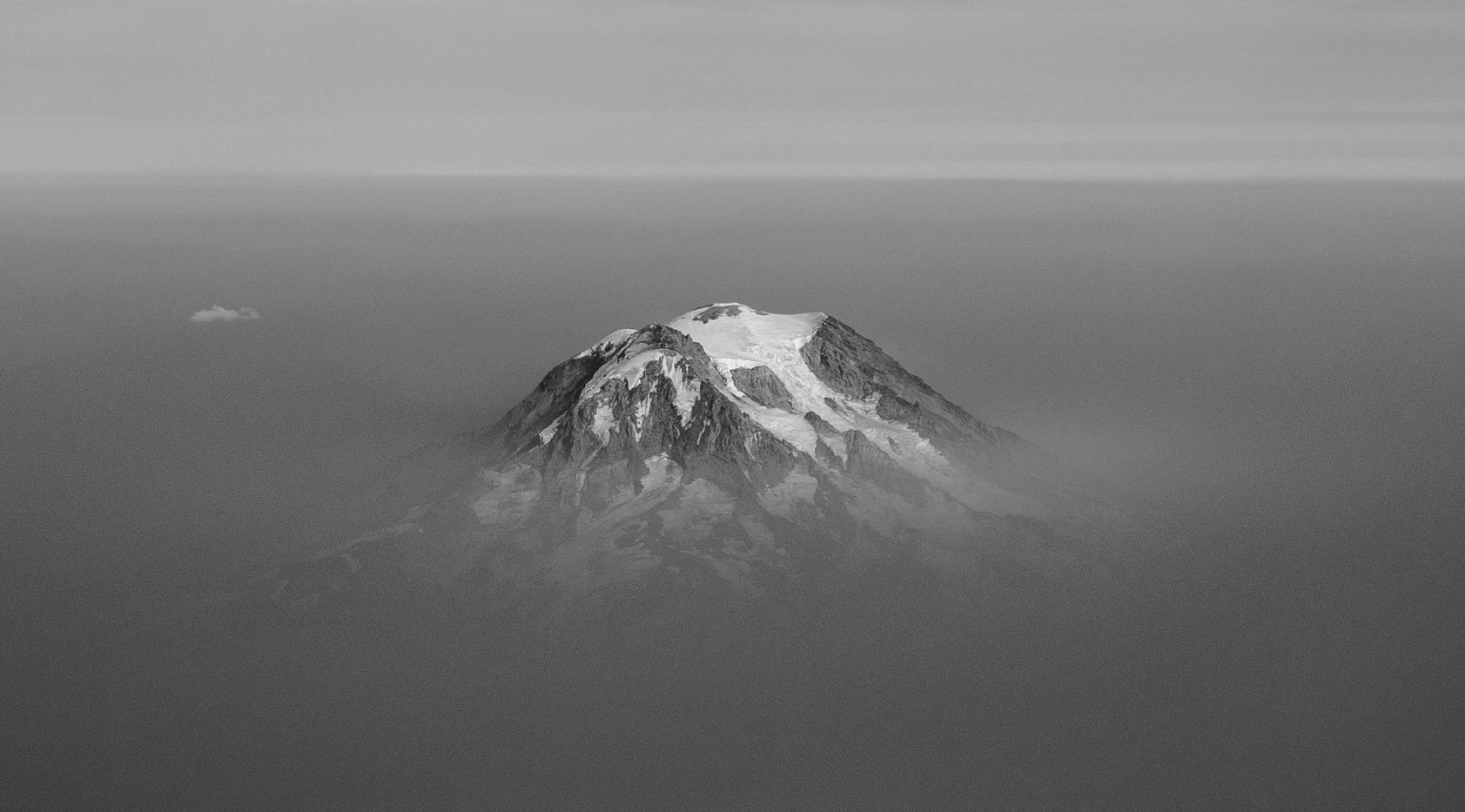
An Li Mount Rainier, Washington. Image taken while flying out of Seattle.
3rd Place
Meghan King
1.9 Billion year old stromatolites with a small fault offsetting the outcrop. Summer 2023 Field Campaign to Great Slave Lake (Northwest Territories, Canada)
Professor Kathy Troost Retires
Kathy Goetz Troost, LG, PhD, is retiring from the UW after 45 years working primarily as a field and engineering geologist. Most of her work revolved around mapping and characterizing surface and subsurface geology; and then sharing that knowledge with clients, students, and the public.
Kathy’s geology career started in the U.S. Midwest, where she received a BS degree (Magna cum Laude) in 1979 from Indiana State University in her hometown of Terre Haute. Amongst all the fossils and field trips, her passion for geology flourished. She moved to St. Louis and began her career as an engineering geologist with Shannon and Wilson (SW).
She transferred to Fairbanks, Alaska and remained there for 5 years with SW. There, she met the love of her life, Roger, was married, and had a son. Kathy worked on some fascinating projects while in Alaska: a permafrost map of Fairbanks, a helicopter-supported geologic hazard reconnaissance for a new transmission line between Anchorage and Fairbanks, helicopter-supported mapping of a new hydroelectric facility near Lake Iliamna, and drilling permafrost core on the North Slope to test for thaw settlement potential along the Alyeska Pipeline.
Kathy and family moved to Seattle in 1985 where she continued her employment with SW. She and Roger had a daughter and settled in by building a house in the Snohomish area. While working for SW in Seattle, Kathy continued to work on some amazing projects including: compiling subsurface data to evaluate groundwater contamination pathways in the Joint Base Lewis-McChord area, mapping the growth of the West Pont spit over the last 5,000 years to facilitate archeological investigations during extensive construction activities, and mapping surface and subsurface conditions for a proposed low-level nuclear waste facility in Illinois and then testifying multiple times during a licensing hearing. She became a professional geologist in Oregon and a licensed geologist in Washington.
In 1998, Kathy enrolled in the Masters
program at UW while still working at SW. Her research focused on the Olympia nonglacial interval in the Puget Sound area under the tutelage of Dr. Derek Booth. She obtained EDMAP grants from the USGS to map quadrangles in the Tacoma area. That project led her to partner with Derek in creating the Pacific Northwest Geologic Mapping Center, or GeoMapNW, where grant money allowed them to create a high-resolution geologic map of Seattle accompanied by an extensive subsurface database. She left SW to focus on geologic mapping in major urban areas of the Puget Lowland and building an extensive subsurface database that ultimately housed detailed data from over 100,000 boreholes. She began her PhD program at UW while working on the mapping project, focusing on MIS 3 glaciation in the Puget Lowland.
GeoMapNW shut down after twelve years, when applied research money became scarce. The database is now hosted by the Washington Geological Survey. Kathy then worked at Troost Geosciences, and amongst her projects was a detailed evaluation of potential submerged shorelines in Lake Washington along the SR 520 route.
She joined ESS and the MESSAGe program in 2012, during its inception. She taught several courses including engineering geology, advanced applied field geology, professional practice, and technical writing. She chaired or sat on over 75 MS degree committees and helped even more graduate students develop their applied research masters’ projects. Ninetyfive percent of MESSAGe graduates are employed in the geosciences, most of which (90%) got their positions with Kathy’s help and connections. Undergraduates have also found meaningful jobs through her connections.
Kathy has routinely shared her expertise of the Quaternary geology of the Puget Lowland in many settings. Her high resolution geological maps and hazard maps of urban areas are widely used in classrooms and for public and private endeavors. Over the years, she has been invited to give many peer reviews, give professional talks, lead field trips, and provide many short courses.
Professional service and outreach have always been a priority during her career. Kathy is driven by a passion to connect research scientists to practitioners and the public. In addition to convening many symposia and leadership activities in professional associations, she served as invited member of the Geology Licensing Board for the State of Washington and serves on the Washington State Mapping Advisory Board. She conceived and coled a 3-day geologic hazards workshop, one day for professionals, one day for the public, and an all-day field trip. She also conceived and co-led a Landslide Hazards Workshop following the devastating Oso Landslide. Hundreds of planners, first responders, and scientists came from around the U.S. to participate in a two-day forum and an all-day field trip to view the results of several landslides.
Kathy on Mt. Baker with her dog Sampson, July 2024. Credit: Kathy Troost

Several students have have voiced their support for, and appreciation of, Kathy’s mentorship, in addition to the quality of her courses and impact on their professional careers.
Dorothy Metcalf-Lindenburger, a MESSAGe graduate (cohort from September 2014 through June 2016) writes, “I was fortunate to learn from Kathy Troost. Her depth of geologic experience, expertise, and connections in the greater Puget Sound area contributed to our growth as geologists. From her legendary mapping with Derek Booth (and others) of the Puget Sound, to her years of consulting as a geologist, to her professional connections and friendships, Kathy made every class and field trip more than a lesson. Additionally, she personalized her teaching with interesting stories and anecdotes. I feel fortunate to have learned from her, and I wish her the best in retirement.”
Andrew Gault (2015 MESSAGe graduate, cohort 2) said in an email “it was difficult to be succinct with all Kathy helped me with throughout my academic career at UW.” He continues, “Without Kathy’s support throughout my time as a student in the MESSAGe Program, I do not think I would have attained my professional success as a hydrologist. Kathy’s willingness to share her immense
industry knowledge and broad network of connections made it possible to complete the degree that launched my career in the water resources industry. I greatly appreciated the tea Kathy shared during my many office visits and the valuable advice she gave. Most of all, I wish to congratulate Kathy as she embarks on this well-deserved new chapter in her life!”
Mary Alice Benson (2019 MESSAGe graduate) described, “Kathy’s knowledge, dedication and caring she brought to the University of Washington ESS department is reflected in all the amazing geologists found in a variety of geoscience professions. I am fortunate and proud to have had her first as a professor, and now as a mentor and dear friend.”
Anjali Manoj (2023 B.S. in ESS) said that ESS 490A: Advanced Field Investigations, taught by Prof. Kathy Troost, was one of her favorite classes in the ESS major. “I knew early on that I wanted to work in the consulting industry after graduation for a couple of years before heading to grad school. Both Engineering Geology and Advanced Field Investigations were excellent and highly practical classes that offered me insight into the types of projects that I will likely work on at a consulting job and equipped me with important skills for the same,” Manoj writes.

Marquis Richardson (2023 B.S. in ESS) said ESS 510 (490A) was also his favorite course. He explained, “This course felt the most practical for the work I plan to do in the future. I gained a lot of skills surrounding field methods and professional writing. Also, any class that gets me outside is amazing and the trips to Sequim/Port Angeles and the Duwamish Greenbelt were loads of fun.”
Now, as an emeritus faculty member in ESS, Kathy plans to finish some of her geologic maps and write several papers. She will continue to engage with students and help them navigate their careers.

Kathy with dog Sampson on Heybrook Ridge, North Cascades, Washington.
Credit: Kathy Troost
Study Shows UW Farm Practices Restore Soil Health
Story by UW College of the Environment
The soil beneath our feet may not often catch our attention, but keeping it healthy can have major impacts on climate change and the overall sustainability of our food production system. A new study of agricultural practices at the UW Farm, led by recent College of the Environment graduate Julia Macray and Professor of Earth and Space Sciences David Montgomery, demonstrated that even relatively small changes to the ways we farm can help restore soil health and sequester carbon from the atmosphere.
“The UW Farm is doing really incredible work, and some very simple agricultural practices have done a lot to improve its soil health,” said Macray, who completed the work as an undergraduate in the Department of Earth and Space Sciences. “It’s an example of the potential for climate remediation and carbon sequestration on a small scale in an urban environment.”
Farming for topsoil
The study focused on the health of topsoil at the UW Farm, a 1.5-acre studentpowered urban farm and educational facility located on what used to be a massive dumping site and landfill. The

researchers measured changes to the topsoil’s thickness as well as the overall amount of organic matter and carbon that it contained over the 20-year period since the farm began operations. Thicker topsoil with more organic matter is generally healthier and promotes better crop growth, while sequestering carbon in the soil keeps it out of the atmosphere and can help slow
the process of climate change. Healthy soil is also less prone to erosion, and can help control flooding.
“The topsoil is where you get most of the microbial and fungal activity in the soil, and that’s where plant roots are getting all their nutrients,” Macray said. “Topsoil is really important for plant health and soil

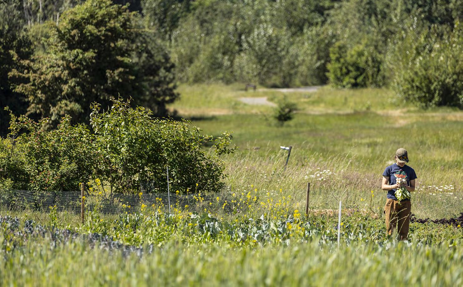
Julia Macray harvests turnips from a row planted with kale and turnips, an example of polyculture on the UW Farm. Credit: UW Photography
The UW Farm grows cover crops in the cooler months to improve soil health.Credit: UW Photography
health in general, and a lot of current agricultural practices will fully erode the topsoil over time.”
Macray found that, under the UW Farm’s regenerative practices, topsoil thickness increased four-fold over the 20-year study period — growing at a rate of just under 1 centimeter per year. Soil organic matter increased as well, but was more variable year to year.
“What Julia’s research showed is that at the UW Farm, they turned a garbage dump into really productive soils in about 20 years,” Montgomery said. “That’s screamingly fast, especially from a geological perspective.”
From landfill to flourishing farm
Located in the Center for Urban Horticulture, near the Union Bay Natural Area on UW’s Seattle campus, the UW Farm sits on land that was once the Montlake Dump, an active landfill until 1966. After significant remediation and restoration work to place a cap of gravel and soil on top of the landfill, the farm broke ground on its first plots in 2002. Given the history of the site, regenerative practices were essential for turning it into productive land.
“There’s no universal agreement on a definition of regenerative agriculture, but I like to think of it as farming practices that can rebuild soil health and fertility,” Montgomery said. “That basically translates into increasing or maintaining soil organic matter and cultivating beneficial life in the soil that enters into symbiotic relationships with crops.”
Modern agricultural practices, especially at industrial scales, are notorious for leaving the soils they use in bad shape. Heavy use of tilling, pesticides and herbicides, and crop monocultures tends to extract nutrients from the soil without replacing them, and kills off the insects and microorganisms that turn organic waste into the stuff plants need to grow. When the topsoil is fully eroded, the results can be catastrophic — like the Dust
Bowl across the Great Plains in the 1930s.
The UW Farm takes a different approach. Instead of heavy tilling, they utilize low- and notill methods which help maintain beneficial fungal networks in the soil. Instead of leaving fields bare in the cooler months, they grow cover crops, such as legumes, that fix nitrogen and other nutrients. Instead of pulling weeds from their plots, they smother them with tarps and let them decompose in place, allowing their nutrients to be recycled. Instead of using chemical fertilizers, they augment their soil with compost, natural soil amendments and fertilizer produced by earthworms in the farm’s vermiculture bins. And instead of a monoculture, they rotate their crops through different plots of land to ensure the soil doesn’t become deficient in specific nutrients.

“People are talking about this more than they did just a few years ago, and consumers especially are becoming more aware of it,” she said. “It’s great to see more small farms using these practices to improve soil health and sequester carbon.”
“The combination of all of these practices led to that increase in topsoil depth and organic matter that we’re seeing,” Macray said. “There’s a good amount of qualitative evidence that this works, and now we’re getting some numbers to support it.”
A model for small farms
Macray acknowledges that these are preliminary results at a relatively small scale, but sees this study as part of a growing body of research that is helping to shift the narrative about regenerative agriculture.
Montgomery is similarly optimistic. “This research shows that we can restore the soil faster than we can damage it,” he said. “That’s big news in terms of thinking about the future of agriculture.”
Scan the QR code to listen to the following episode of FieldSound to learn more about Montgomery’s research.


(Above) Low- and no-till farming methods help maintain beneficial fungal networks in the soil. Credit: UW Photography
(Below) Julia Mccray at the UW Farm. Credit: UW Photography
Paddling Through a Ghost Forest - Evidence of Past Large-Scale

In September 2023, Dr. Brian Atwater, along with graduate students Paul Morgan, Hope Sisley, Andrew Shumway, and Trent Thomas, and postdocs Larry Lai and Jey Kim, led a field trip for the group of incoming grads and postdocs to Copalis, near Ocean Shores, WA. The group set off in nine canoes, their first stop was the Highway 109 bridge over the Copalis River. This bridge, now rebuilt, was destroyed by a tsunami triggered by the 1964 M9.2 earthquake in Alaska. However, the area around Copalis also records much older tsunamis.
Turning around and paddling upstream, the group came to a second site with several outcrops of late Quaternary deposits. During low tide, each outcrop spans approximately 10 meters in width and 2 meters in height. At the bottom of
these outcrops exists a laterally continuous ancient soil layer accompanied by tree roots, indicating a past terrestrial forest environment. This paleosol layer is sharply overlaid by a thin sand deposit, which is interpreted as the result of sedimentation from a tsunami. Above the submerged tsunami sand, a thick marine or tidal mud layer was subsequently deposited, suggesting that this area had experienced sudden land subsidence and marine inundation following a massive earthquake in the Cascadia Subduction Zone.
Today, these strata are preserved under the modern marsh soil surface above sea level. This implies that the land surface has slowly re-uplifted to intertidal and coastal marsh environments, where plants and other organisms have reclaimed the area.
Continuing upstream, the group arrived at the Copalis Ghost Forest. Once a mature forest, these dead trees are evidence of a major earthquake, land subsidence, and tsunamis. Early geochronology studies used radiocarbon dating of materials within the buried, ancient soil to suggest that this abrupt subsidence occurred around the year 1700 CE. However, large uncertainties of this method had prevented geologists from conclusively determining the age within an accuracy of a year.
Fortunately, dendrochronology, the dating of events and environmental change by tree rings, indicated that all the trees in the Copalis Ghost Forest died during the winter of 1699-1700. Salt water inundation in this coastal area “drowned” these trees, leaving behind a “ghost forest”.

Credit: Paul Morgan
Large-Scale Earthquakes in Washington

Stories about a great earthquake and tsunami around 1700 CE are recorded in the historical traditions of indigenous peoples from Vancouver Island to Northern California (Ludwin et al., 2005). Across the Pacific, on January 27th an orphan tsunami – a tsunami with no apparent cause – swept through coastal towns in Japan. Japanese historical records, along with tsunami modeling, confirm that the great earthquake on the Cascadia Subduction Zone occurred approximately 9pm PST on January 26th, 1700. You can read more about this event in Atwater’s book The Orphan Tsunami of 1700.
(Below) Group examines on of the dead trees in the “Ghost Forest”. Credit: Paul Morgan


(Above) Affiliate Professor Brian Atwater at outcrop during low tide. At the bottom of these outcrops exists a laterally continuous ancient soil layer accompanied by tree roots, indicating a past terrestrial forest environment. This paleosol layer is sharply overlaid by a thin sand deposit, which is interpreted as the result of sedimentation from a tsunami. Credit: Paul Morgan
Credit: Paul Morgan


Lab Spotlight
Vigash Ravi, Spring 2024 B.S. graduate, advised by Prof. Kate Huntington
Isotopes are a powerful tool for deciphering information across various fields within the realm of geology. The Stable Isotope Geochemistry Laboratory or Δ*IsoLab was established with the sole purpose to derive and interpret isotopic data for diverse applications. Over the past four years, this laboratory has been my primary research environment, enabling me to conduct studies utilizing isotopes in paleoclimate reconstruction and conservation biology. Isotopes are remarkably versatile.
I was mentored by Dr. Kate Huntington and graduate student Emma Heitmann within the umbrella of their research group and was soon deep within the intricacies of using carbonates for paleoclimate reconstruction. We aimed to discern the historical uplift of the Bidahochi Basin (Colorado Plateau). Under Emma’s guidance, I used carbonate clumped isotope thermometry (T-Δ47) to infer elevation history building off of temperature records. I was really curious to understand how isotopic patterns differ with temperature and how it can be a tool in paleoclimate reconstruction. Isotopes are altered by temperature and altitude change where T-Δ47 is used to infer paleoelevation.
This research experience provided me with invaluable hands-on training and the opportunity to assist Emma in various aspects of her work. I greatly appreciated this opportunity as an undergraduate, as it allowed me to actively participate in activities akin to those of graduate students. Isotope geochemistry, particularly clumped isotope thermometry, is an emerging field with expanding applications. As a young scientist, I find the field’s evolving nature exciting, as it holds potential for diverse applications.
In addition to that, my keen interest in animal conservation and connecting geology to real-world issues led me to undertake the study of pangolins.
Pangolins are sought after for their scales which are used in traditional medicine. The overexploitation of pangolins via poaching has led to a serious population decline. In our project, we looked at 4 pangolin species native to the African continent with samples from two seizures. Lab Manager and Research Scientist Andrew Schauer and I collaborated with the Center for Environmental Forensic Science (CEFS) to determine the provenance of these pangolin scales. We explored the feasibility of analyzing these scales for isotopic composition. While the idea was promising, it took us several months to address a series of critical questions: How do we sample the scales? Which isotopes should we analyze, and what insights can they provide?
We used an Elemental Analyzer attached to an Isotope Ratio Mass Spectrometer (EA-IRMS) that provided Sulfur, Carbon, Nitrogen, and Oxygen stable isotope composition estimates that reflect the preliminary location of origin provided by mtDNA (previously undertaken by CEFS). Based on preliminary provenance estimates from mtDNA, scales were selected for EA-IRMS. The objective was to build a reference iso-map capturing as much of the range of each pangolin species as was available from the seized samples. The data was then used to observe trends in the stable isotope ratios that reflect the origin of the pangolin via Principal Components Analysis. We then placed individual pangolins into groups and then predicted where those groups originated.
We aim to better understand smuggling routes and poaching habits as the long term goal of this project. This project has valuable implications for pangolin conservation and future forensic studies of organic materials that could aid law enforcement in combating these crimes.
Throughout this endeavor, I greatly valued the autonomy IsoLab offered, allowing me to design my own project as an undergraduate. This project was also unique due to its interdisciplinary nature. As a
geology student, conservation biology was outside my primary expertise but I was motivated by my passion for wildlife conservation. Even a small contribution, I believe, can help address the urgent issue of wildlife poaching.
“IsoLab also provided me with an invaluable community, including mentors and colleagues, and exposed me to a
wide range of subjects that motivated me to exlore new areas.”
IsoLab also provided me with an invaluable community, including mentors and colleagues, and exposed me to a wide range of subjects that motivated me to explore new areas. IsoLab was a welcoming and growth-oriented environment where I developed skills and worked with accomplished professionals who became my mentors.
(Top Left) Analyzing clumped isotope data using codes made by Andrew Schauer.
(Bottom Left) Elemental Analyzer attached to an Isotope Ratio Mass Spectrometer (EAIRMS).
(Below) Pulverized samples of Pangolin scales. Images Credit: Vigash Ravi

Field Spotlight
Remote Fieldwork in the Olympic Mountains, WA
Anna Ledeczi, PhD Candidate, advised by Harold Tobin
Just offshore of Washington State sits the Cascadia Subduction Zone – a tectonic plate boundary where the Juan de Fuca plate subducts underneath the North American plate. The fault between these plates is the source of the potential magnitude 9 Cascadia earthquake and tsunami, which threatens coastal communities in the Pacific Northwest today. As the downgoing plate subducts, a “wedge” of sediment builds up offshore which contains the plate boundary fault itself, hosting large earthquakes along it.
In the high Olympic Mountains, there are exposures of highly chaotic and jumbled masses of sedimentary rock, deformed by the process of subduction, known as mélange. These rocks were deposited as sediments around 30 million years ago, which were then subducted and transferred to the overriding North American plate in a process called “underplating” – where sediments are plastered onto the bottom of the plate, compressed into rock, and uplifted and exposed as mountains over time. The mélange rocks in the high Olympics originated at this plate boundary around 30 million years ago, and can thus illuminate features of the fault where earthquakes originate through their structures, mineral compositions, and chemistry.
However, due to the remote nature of the high Olympic Mountains, there has been no geological work conducted west of Mt. Olympus since the 1970s. Since then, the theory of plate tectonics has become more widely researched and accepted, and modern interpretations of the rocks in the Olympics can be made.
A team of researchers from ESS – PhD student Anna Ledeczi, Postdoctoral Researcher Tsai-Wei Chen, and Professor Harold Tobin – has conducted two seasons of field work in an area west of Mt.
Olympus known as “Lakes of the Gods” to see what these rocks might reveal about earthquake processes at Cascadia. They identified what they describe as an exposed fossil plate boundary, featuring 10 major faults contained in a deformed area spanning ~1 km2.
To characterize this exciting newly discovered area, Anna, Tsai-Wei, and Harold used field mapping techniques and took high-resolution images to construct 3D models of key outcrops. Samples collected in the field are analyzed under the microscope back in the laboratory to identify key minerals present and search for evidence of earthquake-related deformation.
Despite its location less than 70 miles from Seattle, the Lakes of the Gods field site is incredibly secluded. Due to federal wilderness protection laws, helicopter operations within the park are severely restricted; however, because there are no trails leading to this area – and because of the importance of the research – the UW team was granted helicopter support to reach the field site. Both in 2023 and 2024, Anna, Tsai-Wei, and Harold were dropped off with food and camping supplies and picked up three weeks later, during which time they encountered no other people.
Planning for this kind of remote field work is an extra challenge. Food must be meticulously prepared in advance and
stored in bear-proof containers to prevent wildlife interest. Anything consumed after the first week must be non-perishable—the only “refrigerator” is a 5-gallon bucket in the lake. Since there is no electricity, a solar panel and battery are used to recharge GPS devices, phones, and iPads.
In the high alpine environment, weather can be another issue. In 2023, several days were too windy or rainy for any geological work, and were spent in the tent. This year, the return trip was planned to begin July 12th, a month earlier than in 2023 due to low snowfall levels early in the season. However, May and June in the Olympics were unusually cold, and resulted in extra snowfall and less than expected snowmelt. The group’s return has been delayed to August or September while they wait for the snow to melt so they can get to the rocks.
(Below) Anna Ledeczi holds a fragile clay “fault gorge” sample collected from one of the fault zones in the field area.
(Top right) Harold Tobin, Anna Ledeczi, and Tsai-Wei Chen posing at their usual lunch spot with White Glacier in the background.
(Bottom right) Harold Tobin, Anna Ledeczi, and Tsai-Wei Chen are excited to be retrieved by the helicopter after conculding field work. The pilot was the first new person they’d seen in three weeks!
Images Credit: Anna Ledeczi


FEATURES

Chasing Totality - The 2024 Solar Eclipse
In early April 2024, four UW Earth and Space Sciences graduate students, Alysa Fintel, Ula Jones, Andrew Shumway and Haskelle White-Gianella, traveled with Research Assistant Professor Baptiste Journaux across the Midwest to witness a life-changing total solar eclipse – the last to be seen in the U.S. for the next 20 years. College of the Environment multimedia producer Sarah Smith joined to document the experience.
While a partial eclipse was observable from Seattle, cloud cover permitting, the group traveled from Seattle to Missouri and finally to Arkansas to reach the center of a narrow 115-mile band of totality stretching from Texas all the way to Maine. In this zone, the sun is fully covered by the moon, creating up to four minutes of darkness in the middle of the day.
The moments preceding totality are characterized by the ability to see the solar corona, the outermost region of the sun’s atmosphere, with the naked eye. “The sun is reaching its peak maximum solar activity in its 11-year cycle. During the solar eclipse we are going to be able to see really cool features like the solar corona,” explained 1st-year PhD student
Haskelle White-Gianella. “It is an amazing life experience for people who study Earth and planetary science,” says Journaux. “This is one of the most rare, and probably one of the most awesome, things you can see on Earth in terms of astronomical observation”.
Though the group was traveling to witness an astronomical phenomenon above, they also took time to understand the local geology beneath their feet. Southern Missouri and Northern Arkansas are made up of rolling hills of limestone
and dolomite, carbonate-rich rocks that are remnants of an ancient sea floor from 400 million years ago.
Along the way, the group stopped to explore caves that were carved into the limestone by millions of years of erosion by rain water. Underground, the group saw unique limestone features as well as fossilized remains of small sea creatures that once lived in the ancient ocean.
This was an important opportunity for the planetary scientists to get out in the


field and get some hands-on experience. Andrew Shumway, 6thyear PhD candidate, studies how water, salt and soil can interact to make liquid water possible on Mars. “Driving through the dolomite limestone layers in the Ozarks and thinking about my research on Mars, where we are also seeing carbonates, and about what environments could deposit those, was a useful educational and research experience for me.”
(Top Left) Haskelle Trigue White-Gianella views the ecplise through the telescope. Credit: Sarah Smith/College of the Environment.
(Bottom Left) The White River in Arkansas from Calico Rock bluff. Credit: Sarah Smith/College of the Environment.
(Above) Image of Sun’s surface. The telescope used is an 80 mm Lunt and has two stacked H-alpha filters. Credit: Baptiste Journaux

The group brought several specialized cameras with them to safely photograph the Sun through the stages of the eclipse. They used a telescope equipped with a hydrogen-alpha filter - which only allows through light of one specific wavelengthto photograph activity in the Sun’s lower atmosphere, known as the chromosphere. The team stayed in Springfield, Missouri the day before the eclipse, so they would be able to enter the path of totality from multiple different angles depending on the cloud coverage day-of. “Following weather predictions from the night before and last-minute predictions at 4 a.m., we ended up at Calico Rock, Arkansas after three hours of driving, where we were able to observe totality without clouds and in perfect conditions, standing on top of beautiful fossilized beach sandstones from 460 million years ago,” Journaux explained.

“Before the eclipse, we could see a ‘sunset’ for a while, but once totality hit, the sky instantly became a dark shade of blue” describes White-Gianella. “Everyone watching with us started cheering. I could feel everyone’s excitement and joy even though my focus was on the sun. I think everyone around us was just as awestruck and emotional as we were”.
“Everyone watching with us started cheering. I could feel everyone’s excitement and joy even though my focus was on the sun. I think everyone around us was just as awestruck and emotional as we were.”
Temperatures dropped 5-10 degrees F from the start of the partial eclipse to totality, and the darkness was comparable to twilight, the time after sunset when the sun partially illuminates the atmosphere, White-Gianella explained. “My favorite part of the eclipse was the part where we could take our glasses off and see Venus and Jupiter,” says 5th-year PhD student Alysa Fintel. While Venus and Jupiter were visible to the naked eye, seeing Jupiter’s moons required binoculars.
“My favorite part of the eclipse was the part where we could take our glasses off and see Venus and Jupiter,” says 5thyear PhD student Alysa Fintel.
“I found myself looking around during totality and just trying to take in that unique environment,” described Ula Jones, a 1st-year PhD student working with Journaux. Ula is curious about where life could exist on other worlds outside of the solar system, and her research focuses on describing the interiors of water-rich exoplanets using fundamental properties of high pressure ice. As a participant in the UW Astrobiology Program, she is excited to contribute to discussions about the potential habitability of icy moons and exoplanets. “UWAB provides a great interdisciplinary research setting that I really benefit from. For instance, my work spans topics between astronomy, oceanography, and ESS, all of which are well represented departments within the program.”
(Left) UW ESS hole-punch shadows mid-eclipse. Without glasses, a safe way to view an eclipse is by making a pinhole projector. Punch holes in a piece of paper and hold over a 2nd piece of paper. You will see an inverted image of the sun projected onto the paper screen through the holes. Credit: Sarah Smith
Credit: Baptiste Journaux
“UWAB provides a great interdisciplinary research setting that I really benefit from. For instance, my work spans topics between astronomy, oceanography, and ESS, all of which are well represented departments within the program.” - 1st-year PhD student Ula Jones.
“This was such an unique opportunity to have with graduate students of our department, to share this experience with them,” says Journaux. “I think it will help them transmit their love of eclipses to their future students.”

Watch on Youtube: Chasing Totality: 2024 Solar Eclipse with UW College of the Environment and ESS.


(Above) Ula Jones punching holes in a UW Astrobiology-themed plate. Credit: Sarah Smith/ College of the Environment.
(Below) From left to right: Alysa Fintel, Andrew Shumway, Baptiste Journaux, Haskelle Trigue White-Gianella, and Ula Jones at Calico Rock, Arkansas. Credit: Matt Powell-Palm.
Seismic Enhancements for the 21st Century

PNSN Field Engineer and ESS Alum Doug Gibbons feels the joy of completing a station installation at Mount St. Helens. Credit: PNSN
Super-sizing the Pacific Northwest Seismic Network in the Era of Earthquake Early Warning
The Pacific Northwest Seismic Network (PNSN) has been a part of ESS in some form since about 1969. Our founding date depends on how you define it, says Emeritus Research Professor Steve Malone, who’s been here for much of that history and still is very much a part of our seismological brain trust. In the early days, PNSN operated a small handful of permanent seismic stations in Washington and later Oregon. Over the course of the 1970s and 80s, our network grew to a little more than a hundred stations, with a focus on the Cascade volcanoes spurred by the 1980 Mount. St. Helens eruption, and stayed about that size through the end of the 1990s. Did you know the UW generates the earthquake information for Oregon and Washington that you find on earthquake.usgs.gov?
But things have changed! Today, PNSN operates a vast system of nearly 800 seismic stations across the two states, with all of the data streaming in real time into our servers 24/7 every day of the year. A number of factors have sped this growth over the years, but by far the most important driver in the past decade has been the development of the ShakeAlert Earthquake Early Warning system – a
partnership among the U.S. Geological Survey and five key universities, UW prominent among them – that covers all of Washington, Oregon, and California.
ShakeAlert has two major elements: the detection of earthquakes as soon as shaking begins at the nearest stations, and a fast and sophisticated set of computer algorithms that are constantly listening to the data streams and can compute earthquake magnitude, location, and predict expected shaking intensities, all within one to five seconds after the first seismic wave hits the nearest station –much faster than the damaging seismic waves spread very far from the origin. If the event is big enough, an alert message is created that is broadcasted to mobile devices by the U.S. Wireless Emergency Alert system (think AMBER Alerts), plus the MyShake app and all Android phones as a built-in feature. Advance warning of shaking of a few seconds to as much as a minute or more for truly massive quakes can give people time to Drop, Cover, and Hold On (and no, getting in the doorway is not a recommended action anymore!). Even better, the alerts also enable a variety of automated actions for our infrastructure, enabling hospitals to stop sensitive
procedures, water systems to be secured for shaking, and more.
All of this depends on having seismometers nearby wherever an earthquake strikes in the PNW. To make that happen, we have doubled the size of PNSN’s instrument network since 2015, including a massive expansion of our ability to send data back (“telemetry”) from stations on mountaintops and ridges, in school buildings and firehouses, and every imaginable site in between. The newest development in ShakeAlert is the incorporation of GPS stations that can help us obtain the magnitude of the largest earthquakes in real time using a method called GFAST, largely developed and implemented here at PNSN.
To do all this, we have gone from a staff of about a dozen a decade ago to 23 full-time PNSN employees in ESS today, including the all-important role of “Duty Seismologist” on call 24 hours a day. And in fact, PNSN is even larger than that, as it encompasses an embedded USGS staff of six here on campus, as well as a tightly integrated partnership with our colleagues and friends at University of Oregon’s Oregon Hazards Lab, which has its own
staff and budget to run most of the network sites in that state. Essential graduate students are also engaged in leading-edge research on, for example, machine learning approaches that can improve our scientific products. Equally important are the undergraduate student workers who help tremendously with everything from field operations to our social media and public outreach presentations.
PNSN has become embedded in the life of the Pacific Northwest, as the original and trusted source of earthquake information whenever folks here feel a little shake. And when a bigger one comes, everyone in our region could be touched by our work through an earthquake early warning. To us, this embodies our ESS mission of great science in support of society.
Visit PNSN.org to learn more about the Network, view an interactive map of recent earthquakes in Washington and Oregon, and read an overview of PNSN’s outreach efforts. Teachers, if you want to shake things up a bit in your classroom, schedule a field trip to the PNSN lab!


(Above) PNSN Field Technician Ben Pratt (ESS alum and former undergraduate reserach assistant) works at the seismic station EDM, on the eastern flank of Mount St. Helens. Credit: PNSN.
(Below) McKenzie Carlson (right, ESS 2022 alum) and Amanda Syamsul (left, ESS 2023 alum), both former PNSN undergraduate employees and now PhD students in geophysics elsewhere, teach a school group all about earthquakes during a school tour of PNSN facilities.
Reading the Landscape

UW geologist connects landslide research with communities in high-risk
regions
Alison Duvall, University of Washington associate professor of Earth and Space Sciences, is working to understand how climate and climate change might affect the frequency, severity and downstream impacts of landslides, and bring what she learns to community partners working to reduce risk in vulnerable places.
When Alison Duvall looks at a mountain, she sees a story about our ever-changing world. As a tectonic geomorphologist, she studies the earth’s surface and the processes that affect it. Her research focuses on places where tectonic plates ram into each other, uplifting mountains and triggering erosion processes such as landslides. The mountain ranges, river valleys and geographic formations that we see today result from many millions of years of tectonic activity.
“If you can read the landscape, you can extract information about events that happened thousands or millions of years ago,” Duvall said. “A lot of my work is theoretical, like using new technology to uncover information about the history of landslides in an area – which can help us project future landslide risks for people who live and work nearby.”
Over the course of her academic career, Duvall has worked to connect her research to the challenges that face people living in high-risk regions.
“I want to make sure that what we study makes its way into communities who need this information, because it’s anything but theoretical if you live near a slope that might destabilize after a quake,” she said.
And it’s not only earthquakes that threaten human lives. As Earth’s climate changes, so do the factors that influence erosional processes. In 2014, a devastating landslide swept across the north fork of the Stillaguamish River near Oso, Washington, killing 43 people. No earthquake preceded the slide, but subsequent research by College of the Environment and College of Engineering scientists found that the collapsed hillside had been saturated and destabilized by heavy, intense rain in the months preceding the disaster. Additionally, Duvall’s team developed new remote sensing methods to estimate the age and
frequency of severe landslides that have occurred across thousands of years.
“If you look at our map, you can see that the entire section of the north Stillaguamish is littered with huge landslides, some even bigger than Oso. That information will ultimately help us to understand the future risk for people in the valley, which I hope will help us prevent the loss of life that we witnessed in 2014. But first, you have to get the right data to the right people,” Duvall explained.
The knowledge gap between scientists and communities is one that Duvall is dedicated to closing. She points to the Cascadia Coastlines and Peoples Hazards Research Hub, or CoPes, as an example of what strong community-based science can achieve. CoPes brings together scientists and engineers with community leaders, social scientists, emergency managers, planners and communicators to help coastal communities be prepared for hazard events like earthquakes, landslides and tsunamis.
Alison Duvall working in New Zealand. Credit: Paul Morgan
“CoPes has been really, really exciting because we are doing important work in service to the community and pushing the boundaries on science, too,” Duvall said. “We’re modeling the potential erosion events that could flow from the next Cascadia earthquake, the next Seattle earthquake, and learning so much from our work.”
In addition to research and community co-learning, Duvall also works to inspire the next generation of Earth scientists as a teacher and mentor. Her graduate students work around the world, including in Chile’s Atacama Desert and New Zealand. Whenever possible, Duvall secures funding to take her students and postdoc into the field together; her communitybuilding has resulted in a group of students who proactively collaborate with each other.
“I get a special kind of joy out of mentorship,” Duvall said.
“I get a special kind of joy out of mentorship,” Duvall said, citing its origins
in her own experiences as a PhD student conducting field research on the Tibetan Plateau. “I got so much from the other graduate students in my research group. In some ways, we mentored each other, and I get so excited when I find my students are meeting together on their own.”
Her students, in turn, offer opportunities for Duvall to continue her own learning. In 2023, Duvall joined doctoral student Tamara Aránguiz for field work in the Atacama, the driest place on Earth.
“I’ve never worked in a high desert environment like that – I felt like I was on Mars!” Duvall said, her face lighting up as she described exploring a field site where everything was new to her. “You can see the faults with the most astonishing clarity, and even the soils are different from anything I’d seen. It’s incredible getting to walk around thinking, ‘I don’t know how any of this works.’”
While she emphasizes that it’s possible to work as a geologist anywhere in the world, Duvall said her experiences are enriched
by being part of the community she studies. “It’s been fulfilling to do research projects in communities where I’m a community member, too. I’ve experienced the things that I’m studying, and that’s really amazing.”
Story by College of the Environment


Scan the QR code below to listen to the full episode of FieldSound featuring Duvall and her research. FieldSound is the official UW College of the Environment podcast, hosted and produced by Sarah Smith.
and Postdoctoral Scholar Larry Lai. Credit: Paul Morgan

(Below) Alison Duvall with her research team in New Zealand. From left to right are recent PhD graduate Erich Herzig, PhD candidate Paul Morgan, Alison Duvall, PhD candidate Tamara Aranguiz-Rago,

UW ESS 1st Open House
The Department of Earth and Space Sciences held its very first Open House at Johnson Hall on April 21, 2024, just one day before Earth Day. This event was organized by the student-led outreach program Rockin’ Out, and visitors enjoyed a variety of exhibits related to Earth and planetary sciences. Participants could look at explosions on the sun’s surface through a telescope, explore rocks and minerals under a microscope, handle dinosaur fossils from the Burke Museum, and even break large rocks with small sledgehammers. This year, there were 14 interactive booths showcasing different topics from the Department.
We estimate that over 200 kids attended the first ESS Open House, plus their parents and guardians, representing all K-12 grades!
Making a pet rock with GeoClub members using paint, googly eyes, and pipe cleaners was a big hit. Visitors also enjoyed learning how to build marshmallow structures that could survive a big earthquake, and they had fun jumping up and down while watching a seismometer (an instrument that measures
ground movement) display their jumps on a screen.
Volunteers from the North Seattle Lapidary & Mineral Club joined us for the Open House, inviting guests to explore rocks, minerals, and fossils from near and far. Visitors even searched through gravel for small garnets that they could take home!
Did you know that there is a lot of liquid water and ice beyond Earth? Visitors learned about the structure of icy moons and dwarf planets in our Solar System by creating their own alien icy worlds!
After exploring the exhibits in Johnson Hall, visitors headed to the courtyard where they made chalk drawings of minerals and dinosaurs on the sidewalk and colored in Earth and planetary science-themed coloring pages of their choice.
The primary goal of the Open House, and similar outreach activities, is to make Earth and planetary science truly accessible to our local communities. All people deserve the opportunity to
learn about the world around them… and we believe that should be fun! The Open House aims to inspire curiosity and motivate more young people in Seattle and the surrounding areas to find and pursue their passions in science.
We are excited to bring this event back next year! Please stay tuned for announcements regarding the ESS Open House later this year and early next year.
Scan the QR code below to learn more about our Open House and to view the full photo gallery. Updates about the 2025 Open House can be found on this website.


Geology’s Girls in the Boat Alumni News
While the world celebrated the “Boys in the Boat” feature that came out in theaters in December 2023, our department would like to celebrate two geology alumae who played historical roles in the University of Washington Husky Women’s Crew – Gretchen O’Donnell and Alida Purves.
Gretchen O’Donnel and the early history of UW women’s crew and geology
With the move in 1895 of UW’s campus from downtown Seattle to its lake-adjacent modern site, rowing soon became a university activity, with competitions among UW colleges and class competitions on “Junior Day” (later called Class Day). Women were rowing as early as 1903. In 1906, the beginnings of a more formal Women’s rowing program featured a “varsity 4” including two geology/mining students: Fanchon Boris and Mayme Lucas. In 1910, the Class of 1912’s boat won the Junior Day competition, with geology major Gretchen O’Donnell (B.A. 1912) as captain and stroke. Crew Coach Hiram Conibear was supportive of women’s crew and gave them what time he could, but he needed help. In January 1910 O’Donnell, recognized for her leadership and athletic skills, became Conibear’s Assistant Coach focused on the women’s program. Facing significant opposition to the existence of women’s crew on campus, Gretchen helped keep the program alive until she graduated in 1912. Within the decade, women’s crew would cease to exist, despite support from Conibear and efforts such
as those of Lucy Pocock (champion oarswoman and sister of George Pocock, leading designer and builder of racing shells, who provided them for the 1936 gold-medal-winning UW “Boys in the Boat” crew.)
In this early period, UW was the first co-ed institution to support a women’s crew, but their only possible intercollegiate opponent was on the east coast at Wellesley College; there was no support for such travel. It was decided that if women competed in at least three sports, they could earn a coveted varsity “W”. Thus, Gretchen also played right halfback in (field) hockey and guard in basketball. At the same time, she was majoring in

The class of 1912 women’s crew in 1910; geology major and crew caption Gretchen O’Donnell is second from left (1911-1912 Tyee yearbook).

The 1997 Varsity 8 celebrating their NCAA champtionship - geology major and coxswain Alida Purves at the back. Photo from UW
Geology, and in her senior year she prepared an annotated Bibliography of Washington Geology and Geography, published by the State in 1913.
As with the crew program, the Department of Geology and Mineralogy also had its origins with the move of UW to its modern site. The first professor was Henry Landes (husband of Bertha Knight Landes, later the first woman mayor of a major city – Seattle). Henry taught the entire curriculum. By the time Gretchen O’Donnell attended UW, the department had moved to the new Science Hall (later called Parrington), and there were three geology professors: Landes, Charles Weaver, and Edwin Saunders. Records of undergraduate majors are spotty; preceding Gretchen there are at least three other women majors in geology or its sister department Mining Engineering.
The UW women’s crew revival and 1997 champion coxswain geology major Alida Purves
In the late 1960s, women’s crew at UW was revived as a club sport and had their first intercollegiate competition in 1969. The next year, legendary rower and future UW coach Jan Harville was recruited to row for the women. In this second set of early years, despite the women’s program being clearly subsidiary to
(Left) Gretchen O’Donnell senior class picture and record (1911-1912 Tyee yearbook). The cartoon with her yearbook photo shows her in a W sweater holding a hockey stick. Clearly a class leader, she participated in several other leadership roles on campus including assistant editor of the Tyee, member of the Women’s League, WAA, Spanish Club, Senior Class Secretary, Varsity Ball Committee, Associate Editor for Junior Daily, and Senior Class Historian.
the men’s, the women not only persisted, but they also won their first National Women’s Rowing Association championships in 1971 and 1972. Title IX in 1972 helped coach Kit Green claim more resources, and in 1975 women’s rowing once again became a varsity sport.
Fast forward a couple decades to a high school senior in Virginia, captain of her senior-year crew with a passion for rowing, mountains, geology, Russian, and her Christian faith. UW geology major Alida Purves (B.S. 2000) writes, “UW was the only option that fit all my criteria.” Alida contacted head coach Jan Harville and came out for a visit; too small to row collegiately, Purves switched to the position of coxswain. She earned the cox spot on the Freshman 8 crew, then the Junior Varsity Crew, and in her junior year became cox of the Varsity 8. That year—1997 was the first NCAA championship for Women’s Crew. Washington won the day with the Varsity 8 taking 1st place, the Junior Varsity 8 and the Varsity 4 each finishing second place. This secured the first Women’s NCAA

crew website.
Coxswain Alida Purves in 2008 with the UW Hall of Fame wall.
championship title for Washington. In 2008, the entire 1997 Women’s Crew Team was inducted into the Husky Sports Hall of Fame; on the 1997 team, another geology major, Tasya Gray (B.S. 1998) rowed the JV 2nd 8+. In 2016, when the Pac-12 named the 1936 UW Men’s Crew of Boys in the Boat fame as their Men’s Crew of the Century, the 1997 Varsity 8 boat that Purves coxed was named the Pac-12’s Women’s Crew of the Century.
‘Being in the geology department wasn’t just about learning, it was about developing relationships.”
Also in 1997, double-major Alida won the Merrill Prize for the Geological Sciences outstanding undergraduate major. Alida’s other major was in Russian Language and Literature; when Professor Jody Bourgeois learned of this double skill, she recruited Alida to translate the Kamchatka tsunami catalog. Alida recalls that by far her most memorable experiences in the department were her two years in field camp, the first as a student and the second as an undergraduate TA. The first year, she remembers Professor Stu McCallum finding that her group had unknowingly strayed completely out of the mapping area.
Consequently, the next day Stu followed Alida and her mapping partner around, reciting Scottish poetry as he made sure they did not stray too far. The following year, Professor Eric Cheney directed the field camp and was also Alida’s department advisor. When he learned that she planned to serve eighteen months as
a church missionary (in Russia) before graduating, he advised she finish her degree first, but ended up being very supportive of her decision: “I can’t lie, I was terrified of Eric… [however] that summer at field camp…Eric was amazing…so supportive of me. I feared needlessly. He loved used bookstores and even got me two gifts. I still have them – one was a classic geology textbook he found, and the other – an old James Bond novel –To Russia with Love.”
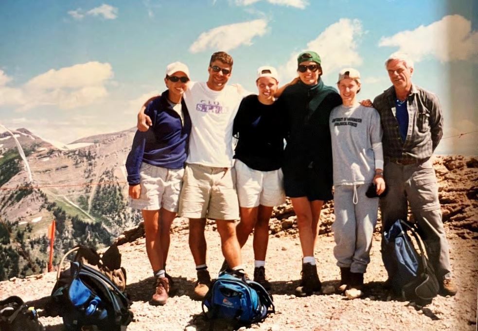
Alida shared several other memories – a Yellowstone hike, a USGS internship in Oregon, a field trip with Affiliate Professor Don Swanson to Mt. St. Helens, and Professor Darrel Cowan being “another stellar person and geologist.” In sum, she says, “Being in the geology department wasn’t just about learning, it was about developing relationships. I was so grateful for the experiences I had with these professors and how they really took an interest in helping me become the best I could be.” Marrying former UW rower Zack Abbott in 1999 and graduating in 2000, Alida Purves Abbott earned a Masters at UC Davis in Water Resources Engineering and worked on water resources projects in Northern California for a couple years before leaving the workforce to raise and homeschool six children, two adopted. The family now lives in Olympia, Washington, and Alida is glad to be back in touch!
Below: ESS Geology field camp in 1997, taught by Eric Cheney (far right), when Alida (next to Eric) was an undergraduate TA. From Alida’s right, [unidentified], Jody Broadie, Alan Hughes, and Tasya Gray.
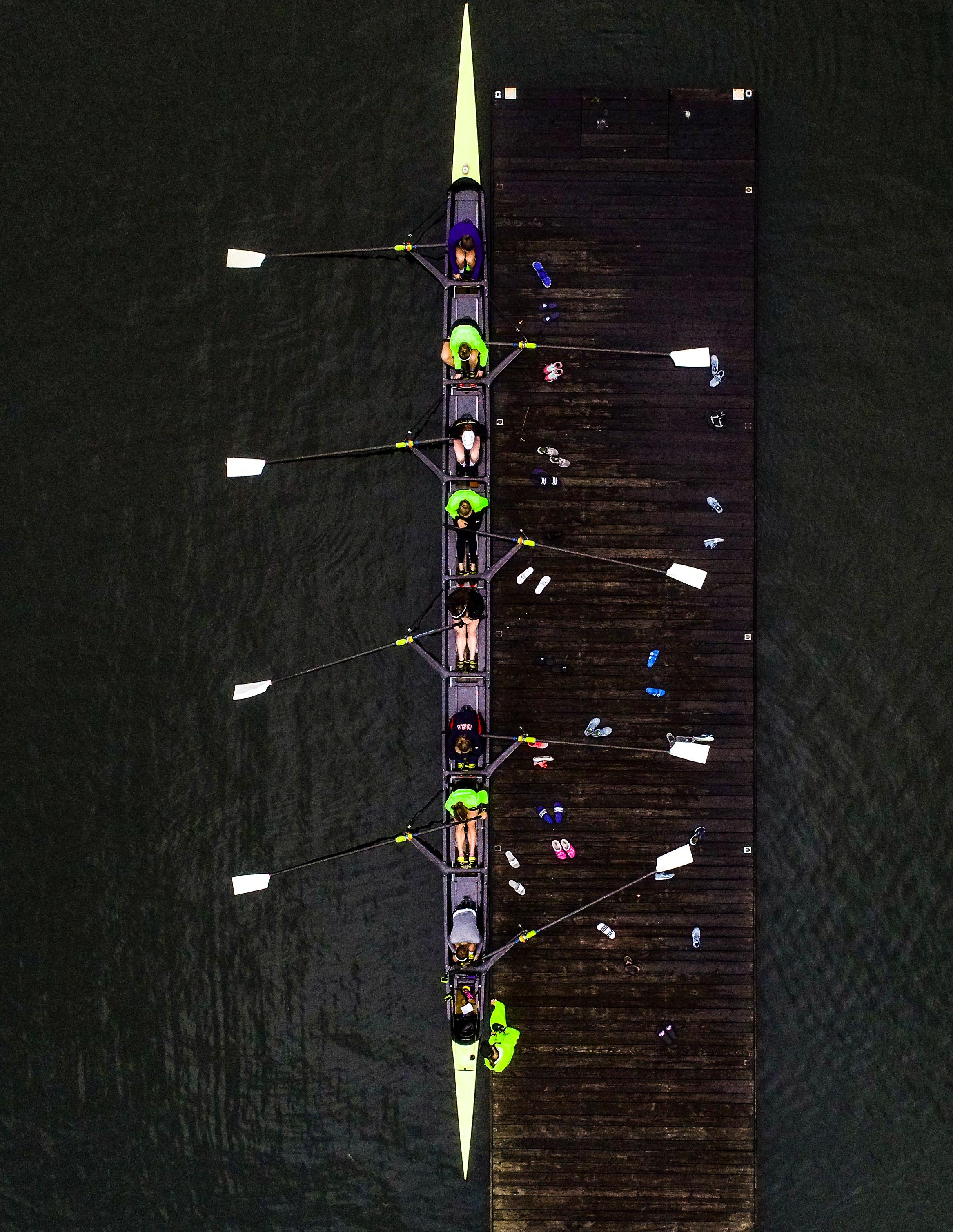
UW 2019 Women’s Crew practice. Photo
Credit: UW Photography / Mark Stone
OPEN GEOLOGY
ESS Alums and Faculty contribute to public geological education in the western U.S.
Locals interested in learning more about Washington State geology may be familiar with Roadside Geology of Washington (2nd ed.), authored by UW geology alum Marli Miller (M.S., 1987; Ph.D., 1992) and Professor Emeritus Darrel Cowan. Farther afield, Marli has generated public-geology books about Oregon and Death Valley. Marli’s contemporary in grad school at UW, Rob Thomas (Ph.D., 1993), has also been heavily involved in public geological education and is co-author of Roadside Geology of Montana and Roadside Geology of Yellowstone Country
ESS alums who have taken field camp in Dillon may well have met Rob Thomas, who teaches at Montana Western, lives in Dillon, and helped UW ESS develop the Montana field course, led for many years by Darrel Cowan. Marli has also brought [Oregon] students to Dillon for field camp, and ESS alums who have taken Darrel’s geology trip to Death Valley may have met Marli there, where she has done both research and teaching.
A Senior Instructor II in the Department of Earth Sciences at the University of Oregon, Marli Miller has focused on teaching, ranging from Geology 101 to Structural Geology (her specialty) and Field Camp. In addition to the Roadside books, she has generated two volumes in the Rocks! series – Oregon Rocks! and Colorado Rocks! (the latter with Magdalena Sandoval Donahue), with Death Valley Rocks! upcoming. Marli is also an expert geophotographer and makes her photos (and an occasional blog post) freely available at https://geologypics.com/.

“I love geology and talking about it —and I find that most people I know get pretty excited by the topic. I like to think that the more awareness we have of Earth processes and geologic time, the more we’ll be able to approach a whole host of environmental and even cultural issues with thoughtfulness and humility” writes Marli.


Marli Miller showing thrust-fault cross sections while in the field.
As Regents Professor of Geology in the Environmental Sciences Department at University of Montana Western, Rob Thomas also sees public education as a primary calling. At present, Rob is also working on a Rocks! book – Montana Rocks!, hoping to complete it next year. In addition, Rob has generated educational brochures (some as student projects), run GeoVenture field trips with GSA, generated 25 geologic road signs (with Sheila Roberts), and taught trekking and climbing guides in the Himalayas. His Montana Geology Facebook page has more than 16,000 followers. Rob writes, “My primary interest throughout my geologic career has been public outreach. I enjoy traditional academic research and understand it is necessary for me to stay on top of my discipline, but…given the status of public understanding of how the Earth works in America, I can think of no better way to use my time and training.”
Marli and Rob have great memories of ESS (then Geological Sciences), where they were both denizens—in fact, office mates–of “the Barn” (a rickety 1908 wooden structure in Johnson courtyard that deserves its own story). Rob writes, “My interest in teaching was strong while a student at the University of Washington. I had a few excellent role models…, and many chances to teach through my work as a teaching assistant.” He also recalls “realizing the importance of the use of good research for public good through the work on the Cascadia tsunami project with Jody Bourgeois and Brian Atwater.” Some of Marli’s favorite memories include “going on Darrel’s extended field trips to the desert SW, walking into Floyd’s office to use the fancy typewriters, and always feeling welcomed, interacting with other grad students in the Barn.”
Amongst others, both Marli and Rob cite Darrel Cowan as an inspiration and role model. In addition to Darrel’s aforementioned co-authorship of the Roadside Geology of Washington, he has recently been featured by Nick Zentner in an interview podcast and on YouTube videos in Nick’s “Exotic Terranes

A to Z” series. These public-education productions include one of Darrel’s long-term research areas, the San Juan Islands, where he has also run many field trips. Last but not least, one of Darrel’s major public contributions has been his co-founding and maintenance of the Shoshone Education and Research Center (SHEAR) just outside Death Valley National Park. Research and teaching groups from around the country and beyond, including many ESS students, have been able to use this facility, at reasonable rates, while they learn about the geology and natural history of the region.

Watch on Youtube: Mount Baker Exotic Terranes with Darrel Cowan and Gary Paull.
https://youtu.be/lRNwbEUWa j4?si=Ry7-pcHhWwj-dqNM
(Above) Rob Thomas in the field. (Below) Darrel Cowan with Mt. Shuksan in the background, from Nick Zentner’s Youtube video.

ESS Alumni Climbing into History
Not surprisingly, over the years, UW geology and geophysics students and faculty have enjoyed and excelled at rock climbing and mountaineering. In the 1930s, professor-to-be Howard Coombs (1906-1990) was a park ranger at Mt. Rainier, climbed the mountain more than 30 times, and wrote his dissertation (1935) on geology of the National Park. Next-generation professor Joe Vance (1930-2021) was among the elite first 10 climbers who summited all 100 of Washington’s highest peaks. Former graduate student Margi Rusmore (M.S. 1982, Ph.D. 1985) was already a skilled climber in her teens and in 1978 was part of the team that put the first American women on the summit of Annapurna. Joining this list of elite climbers is recent graduate Colin Haley (B.S. 2009), an active, world-renowned mountaineer (https://colinhaley.com/).
It’s not possible to discover much of what must be a prodigious and mostly undocumented history of all the UW geo-climbers over the years. But a reference we found to “Jim Crooks” as a climber set us on a quest to learn more. James William Crooks (1921 – 1991) came to our attention when we looked into the history of the Afton Woolley Crooks and James William Crooks Endowed Scholarship in Geological Sciences. Afton Wooley (1925 – 2018) was an English major (B.A. 1947) who met Jim (B.A., 1952 in Geology and Geography) at UW while she was pursuing graduate studies. Afton and Jim married in 1954 and moved to northern California, where she became a university administrator, while Jim established a career as a cartographer and commercial artist.
Like many of his generation, Jim had served in World War II before finishing his degree. He also, before and during his military service, spent time as a serious climber. The first record we have found of Jim’s climbing is of his “first ascent” of Sinister Peak in 1939. In the next year, Crooks (white hat) can be seen on a preserved film leading 17-year-old Fred Beckey (red hat) up the southeast face of The Tooth, near Snoqualmie Pass (https://www. mntnfilm.com/en/film/ascent-of-the-tooth-1940). That same year, Crooks participated in first ascents of Forbidden Peak, Garfield Mountain (South Route), East Peak of Mount Arriva, and North Ridge of Cutthroat Peak.
In perusing the records of Seattle’s Mountaineers organization (whose first president, in 1906, was UW founding Geology Professor Henry Landes!), we next found Jim Crooks in 1942 listed as serving as a Sergeant in the Army. And the next “first ascent” we found was in 1944—and far from Washington State— Conn’s East, Seneca Rocks, West Virginia. What was Jim doing there? You might have guessed.
The United States’ famed 10th Mountain Division (U.S. Army) primarily trained in Colorado at Camp Hale. Jim Crooks served as a Sergeant in the 86th Infantry of the Division, where he taught skiing and climbing to the troops. When the 10th Mountain Division started planning maneuvers for the Italian Apennines, they realized that a more realistic geologic and climbing analogue was at Seneca Rocks in West Virginia. Seneca Rocks is a 900-foot blade of Silurian, quartz-rich Tuscarora Sandstone [an equivalent formation underlies climbing routes in the Shawangunks or “Gunks” in New York State]. So, in 1943, instructors were sent to Seneca Rocks to set up a climbing school in preparation for the assault on Mt. Belvedere in Italy.
Jim Crooks’ 86th Infantry left for Italy on 11 December 1944; upon arrival they moved toward Mt. Belvedere to prepare for a surprise mountain attack to capture the high ground from German occupation. There was 4-5 feet of snow on the ground; each soldier carried a pack of 45-55 pounds, including four blankets because sleeping bags were not available. At the onset, the unit was responsible for defending an area of rugged terrain. “The (Germans) held all the high ground, and one felt like he was in the bottom of a bowl with the enemy sitting on two-thirds of the rim looking down upon you,” a soldier said.
To take Mt. Belvedere, the soldiers first had to capture “Riva Ridge.” The attack on Riva Ridge kicked off at 7:30 p.m. Feb. 18 with 700 1-86th Infantry Soldiers beginning the 1,700- to 2,000foot climb. In military history, the 10th Mountain Division’s attack on Mt. Belvedere is renowned for its daring, its difficulty, but ultimately its success (see, e.g., Bootprints in History: Mountaineers take the Ridge). Fortunately, Jim Crooks came home in one piece, and with help from the GI Bill, earned his degree in 1952.


(Above) Colin Haley (UW ESS B.S. 2009) and Alex Honnold with legendary climber Fred Beckey in 2019. Colin presented Fred with The Mountaineers Lifetime Achievement Award at this event. Credit: The Mountaineers.
(Right) U.S. Soldiers-in-Training at Seneca Rocks, WV (from The West Virginia & Regional History Center).
(Below) Preserved film of Jim Crooks (UW Geology 1952), white hat, leading 17-year-old Fred Beckey (red hat) up the southeast face of The Tooth, near Snoqualmie Pass in 1940. From MNTNFILM Ascent of The Tooth.
excerpted from


(Left) Seneca Rocks, West Virginia. Image
photo by Jarek Tuszynski, Wikipedia.
ESS Graduation Class of 2024

Distinguished Alumni Speaker
Dr. Zachary Adam
Zachary Adam (UW-ESS, B.Sc. ’04) grew up in the Wenatchee Valley and was fortunate to begin his academic training at the University of Washington in 1999. The foundational courses he took there on the intricate connections between the Earth and the life it supports have been usefully applied in the years since. Zach worked for the federal government as a launch vehicle inspector on the Boeing SeaLaunch, Orbital Sciences Cygnus, Boeing Starliner and Spacex Falcon 1, Falcon 9 and Dragon programs, evaluating their respective life support systems designs and atmospheric debris burnup calculations. After leaving public service, he studied Precambrian micropaleontology and eukaryote paleobiology at Montana State University and Harvard University, and today he continues to study the chemical origins of life and the environmental circumstances that led to the origins of complex life as a Staff Scientist at the University of Wisconsin-Madison.

Graduate Speaker
Susannah Morey, PhD
Susannah received her doctoral degree from Earth and Space Sciences studying megafloodslarge dam break outburst floods that have discharges of over a million cubit meters per second. She used hydraulic modeling, field work, sedimentology, geochronology, and landscape evolution modeling to assess the impact that megafloods have had on the eastern Himalaya. For her teaching, Susannah was awarded the Howard A. Coombs Teaching Excellence Award. She also served as the Graduate Student Representative to the Faculty, on the Curriculum Committee, a Faculty Search Committee, and she co-founded the ESS Graduate Student Justice, Equality, Diversity & Inclusion (JEDI) Reading Group in 2020. For her service to the community, in 2023 she was awarded the Julian D. Barksdale Distinguished Service Award. In August 2023 she started a position as a postdoctoral associate at the Cooperative Institute for Research in Environmental Sciences at the University of Colorado Boulder.

Baccalaureate Speaker
Jinqi (Klay) Wu, BS
Jinqi (Klay) Wu graduated with a major in Earth and Space Sciences, focusing on Geoscience, with departmental honors. Klay has received several prestigious awards, including the Afton Woolley & James William Crooks Scholarship, the Mary Gates Scholarship, the Julian & Marajane Barksdale Endowed & Joseph A. Vance Endowed Student Support Fund, the Douglas E. Merrill Prize for Excellence, and the “Rising Rockstar” Award for Best Undergraduate Talk. Since sophomore year, Klay has been a member of Professor Fang-Zhen Teng’s lab, conducting research on stable isotopes, particularly Mg and K isotopes, and their behavior during subduction dehydration metamorphism. In addition to his research, Klay has actively mentored junior fellows in the lab and class, serving as a teaching assistant and sharing experiences to support and guide his peers. Klay will continue his studies at Harvard University, pursuing a PhD in cosmochemistry.

Department of Earth and Space Sciences Class of 2024, PhD and Masters Graduates

Department of Earth and Space Sciences Class of 2024, Bachelor of Science and Bachelor of Art
We encourage our alumni to share their current endeavors and updates with us; your stories are always inspiring and greatly appreciated. Please send any updates to essdept@uw.edu. Your continued support plays a crucial role in advancing our department and enhancing our programs. Thank you for being a vital part of our community and for helping to shape the future of Earth and Space Sciences at UW.
To learn more about making a gift to Earth & Space Sciences, please contact Eryn Boyles Ilk, College of the Environment Director for advancement at boyles@uw.edu or 206-372-3796.
You can learn more about Department giving and our funding priorities on our website at https://ess.uw.edu/ alumni-community/give/ or scan the QR code (right).

Department of Earth & Space Sciences
University of Washington
Johnson Hall Room 070, Box 351310
1707 NE Grant Lane
Seattle, WA 98195
