Rebecca Andersen
Sara Dant
By William T. Parry
Rebecca Andersen
Sara Dant
By William T. Parry
 Laurie J. Bryant
89 UHQ I VOL. 90 I NO. 2 CONTENTS 92 Bound to the Land Cove Fort in Kesler Family History and Memory By
110 Driving Utah’s Rivers Working Water in the West By
134 The Mining Legacy of William S. Godbe
150 The Salt Lake City Asylum and Hospital, 1870–1886 Mental Illness in Early Utah By
DEPARTMENTS 91 In This Issue 165 Reviews 172 Contributors 173 In Memoriam 176 Utah In Focus UHQ 90_2 Text.indd 89 4/8/22 1:36 PM
REVIEWS
165 Reconstruction and Mormon America
Edited by Clyde A. Milner II and Brian Q. Cannon
Reviewed by Reilly Ben Hatch
166 Carbon County, USA Miners for Democracy in Utah and the West
By Christian Wright
Reviewed by Nichelle Frank
167 Traditional Navajo Teachings A Trilogy
By Robert S. McPherson and
Perry J. Robinson
Reviewed by Ronald P. Maldonado
169 The Last Canyon Voyage A Filmmaker’s Journey Down the Green and Colorado Rivers
By Charles Eggert
Reviewed by Christian Filbrun
90 UHQ I VOL. 90 I NO. 2
UHQ 90_2 Text.indd 90 4/8/22 1:36 PM
In This Issue
On summer evenings, LeGrande Davies and his grandfather Otto Kesler loved to sit outside their Cove Fort home and watch the sunset, while a group of coyotes began its serenade. Davies recalled that “‘Grandpa would always say, “Ah. Can’t they sing well. Can’t they sing well.” There was a peacefulness that would come because the wind quits blowing in the evening.’” So notes Rebecca Andersen in the opening article of the spring 2022 Utah Historical Quarterly, which focuses on land in the Intermountain West and a handful of the entities—whether personal, familial, or corporate—that have made a living off it. The action in this issue takes place mainly in Utah but also in Nevada, Wyoming, and other neighboring states, on the traditional homelands of Indigenous tribes, a testament to the reality that watersheds, economies, and interpersonal networks do not always adhere to neat political boundaries.
In 1903, William Henry Kesler moved his family to Cove Fort. Ira N. Hinckley had built the fort, located in Millard County at an elevation of some six thousand feet, in 1867. By the time Kesler arrived, it was almost a ruin. But over the course of the twentieth century, generations of Keslers renovated and cared for Cove Fort and the land it occupied, using it as a ranch, way station, and destination for tourists. Drawing from oral histories, Andersen contextualizes the Keslers’ experience within the broader changes of the twentieth century as the family “fought to maintain sense of autonomy, a way of life and understanding of the past that shaped their identity and relationship to the land.”
Next, Sara Dant presents an extensively researched history of log drives along the Weber River and other waterways. A regional market for timber grew in the final decades of the nineteenth century, stimulated in large part by the development of railroads and mines. Entrepreneurs in Utah and elsewhere answered this demand by cutting thousands of trees in mountain forests and driving the hewn logs down river to
their next destination. As Dant observes, “In the arid West, water is the essential element,” providing both sustenance and “highways of timber commerce and trade.” This financially significant industry also had a negative impact on the region’s forests and waterways, a fact that was observed by Albert Potter, Reed Smoot, and others.
Our third article continues the theme of regional resource extraction with William Parry’s account of William S. Godbe’s mining activities. From the 1860s onward, Godbe and his eight sons were deeply involved in the mineral development of Utah and Nevada. The Godbe men opened mines, combed through tailings, founded companies, created new chemical processes, and much more in their search for mineral wealth. In these endeavors, they met with only partial success and, unfortunately, damaged their own health and, presumably, the health of their employees and the land.
Laurie Bryant rounds out the issue with an article that pieces together the history of Utah’s first hospital for the mentally ill: an institution run both publicly and privately that had a decidedly rocky career and became part of the religious and cultural tensions that were so present in late-nineteenth-century Salt Lake City. In reconstructing a history of the asylum, Bryant also pays tribute to its patients—people who endured much and yet whose lives were infinitely valuable.
91 UHQ I VOL. 90 I NO. 2
UHQ 90_2 Text.indd 91 4/8/22 1:36 PM
Bound to the Land: Cove Fort in Kesler Family History and Memory
BY REBECCA ANDERSEN
At an elevation of 6,000 feet, Cove Fort, Utah, is a zone of physical and cultural transitions, a land of extremes.1 In the summer, daytime temperatures can soar over a hundred degrees Fahrenheit before plummeting at nightfall. A frost visits every month of the year. Winters are especially harsh. It is not uncommon for temperatures to register twenty, even thirty, degrees below zero. The wind blows constantly, pausing only at sunset, leaving the air breathless and suspended.2 There is water, but it is locked deep underground, reachable only by machine-drilled wells. Any surface water comes from snow melt that trickles down mountain draws and canyons from the east. By mid-May, sometimes early April, these sources run dry. Like much of the Great Basin, Cove Fort country is affected by eastward moving Pacific storm systems. The Sierra Nevada trap most of the moisture from these systems; the north–south running mountain ranges that fold and ripple across the Great Basin catch what is left.3 The grasslands and meadows that initially attracted Mormon herdsmen exist in delicate balance, reliant upon this seasonal flow. Overgrazing attracts sagebrush and cedar, which suck away the runoff and choke future germination and growth.4 Situated on the west side of Highway 91, Cove Fort stands apart, like a sentinel over the small valley entrusted to its care. The fort’s thick rock walls are rooted to the land as if they were some hardened, volcanic outcrop. Giant black locusts tower over them, their branches reaching like fingers to the sky, pitching and swaying in a rhythm all their own.
Since the mid-1990s the Church of Jesus Christ of Latter-day Saints has operated Cove Fort as a church historic site where visitors encounter a narrative that emphasizes the faith and sacrifice of Mormon pioneers in settling and colonizing a difficult land. They learn that in 1867 Brigham Young called Ira N. Hinckley to be in charge of the construction of what became officially known as Cove Creek Ranch Fort, or Cove Fort. The fort was to be part of a larger network of such structures built in response to Utah’s Black Hawk War. Two years earlier, an altercation between Mormons and Ute tribal leaders in the town of Manti plunged the region into a series of violent, internecine conflicts. A formal peace treaty was
92 UHQ I VOL. 90 I NO. 2
UHQ 90_2 Text.indd 92 4/8/22 1:36 PM
not reached until early 1868, and it ultimately resulted in the removal of the Ute peoples onto reservation lands far to the northeast. The history recounted at Cove Fort pointedly emphasizes that although the fort was constructed for defensive purposes, it was never attacked. Instead, Hinckley and members of his family lived and operated it as a ranch and way station from 1868 until the early 1880s, when the newly completed Utah Central Railroad significantly reduced overland traffic and lessened the need for a formal way station in the area. By 1890, church website material relates, the Hinckleys had left Cove Fort for good and the church leased the land to others.5
Historic site interpretation is admittedly challenging. Remembering and forgetting occur simultaneously as one historical narrative replaces or suppresses another, creating what the anthropologist and historian Michel-Rolph Trouillot famously termed the “silences of the past.”6 Understandably, the church’s acquisition of Cove Fort, its restoration, and ultimate interpretive strategy most likely stem from the fact that Ira N. Hinckley was grandfather to the then-president of the Church of Jesus Christ of Latter-day Saints, Gordon B. Hinckley. As a result of these choices, Cove Fort’s historic significance is unfortunately obscured. Little mention is made of the family members who helped build the fort or, more notably, the site’s difficult history, constructed as it was during one of
the West’s most significant yet little researched or understood Native-settler conflicts. Moreover, this narrow interpretive strategy ignores Cove Fort’s later history as both a home for the William Henry and Otto Kesler families and as a stopover for countless automobilists traveling along Highway 91. Indeed, Cove Fort existed as a base for the Kesler family’s expanding ranching operations and as a minor tourist attraction far longer than it did under the care of Hinkley or anyone else.
It is Cove Fort’s twentieth-century history as a ranch and service station that I relate here. In doing so, I contextualize this history within existing literature on tourism in the West and explore how the Keslers creatively managed the land while capitalizing on the fort’s distinctive heritage and its location along Highway 91, one of Utah’s busiest thoroughfares before the coming of the interstate. The Keslers’ management of Cove Fort speaks to the way in which tourist destinations impacted everyday life on the periphery. Locals like the Keslers adapted to and even benefited from changing times. They also fought to maintain a sense of autonomy, a way of life and understanding of the past that shaped their identity and relationship to the land. As Hal Rothman observed, places have identities: “Human-shaped places, cities and national parks, marinas and farms, closely guard their identities. Their people are located within them in ways that create not
93 UHQ I VOL. 90 I NO. 2
UHQ 90_2 Text.indd 93 4/8/22 1:36 PM
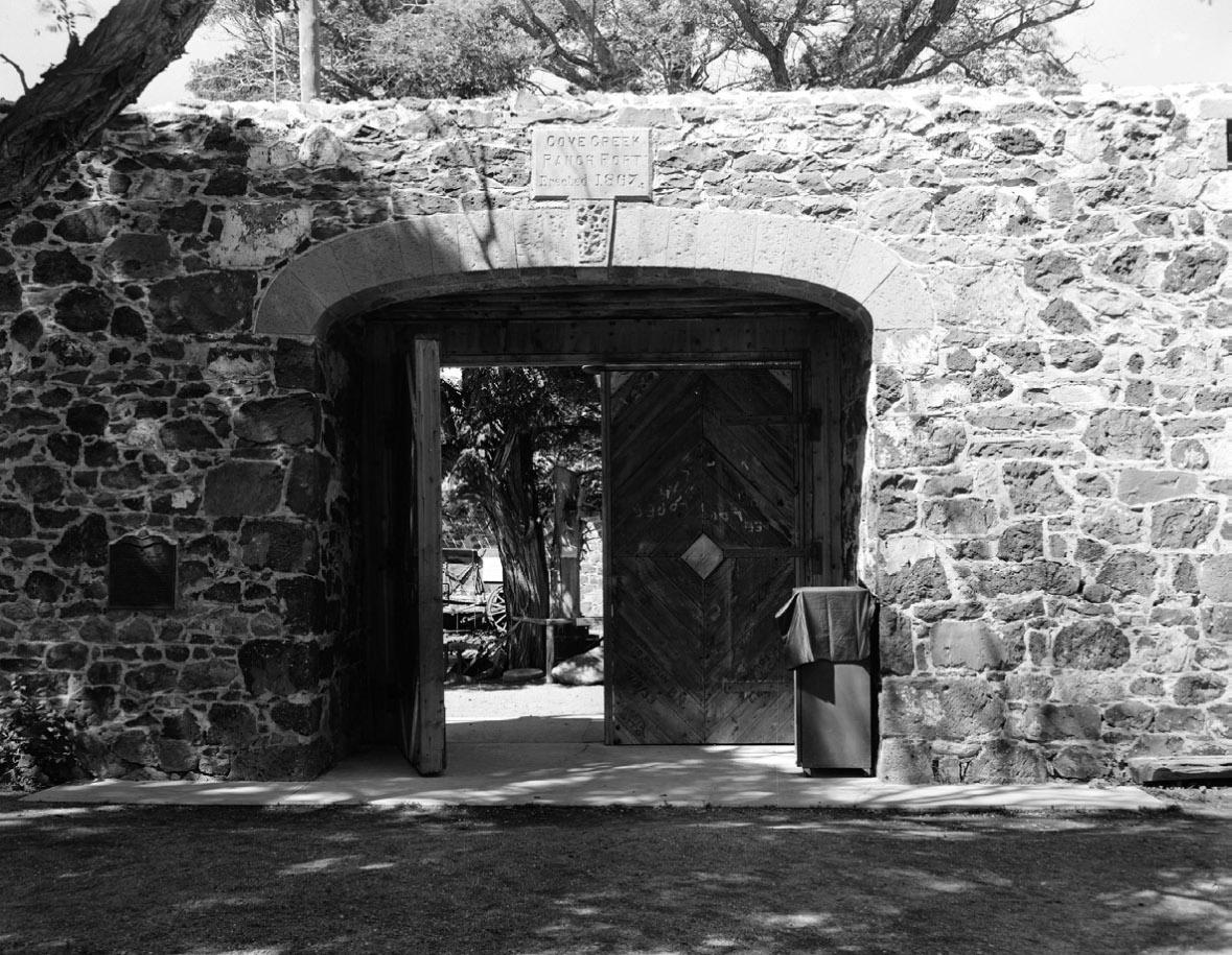
The east entry to Cove Fort, August 1968, as photographed by P. Kent Fairbanks for the Historic American Buildings Survey. Courtesy Library of Congress, HABS UTAH, 14-COVFO,1—4.
only national, regional, and local affiliation but also a powerful sense of self and place in the world.”7 In a sense, the Kesler family’s historic ties to Cove Fort is Rothman’s thesis in microcosm. For most of Cove Fort’s history, the Keslers called it home. They lived in the fort and worked the land to make it productive for livestock, developing an intense connection with the place that remains to this day. It was only when others threatened to remove the Keslers from Cove Fort that the family worked to make the site more accessible to passing travelers, finally turning the fort into a museum in the early 1960s. As the gatekeepers to Cove Fort’s history, the Kesler family’s experiences illustrate the politics of preservation: what gets preserved and why, along with how historical narratives are created and shaped.
In relating this narrative, I rely extensively on oral history. Larry Porter first interviewed Otto Kesler in 1964 while researching his master’s thesis, the only scholarship on Cove Fort currently available. It is clear from these interviews that Porter hoped Kesler could tell him more about Cove Fort’s early history, original layout, and outbuildings. Kesler did this and more. Fortunately, Porter provided the Kesler family with a recorded copy of this interview, which I obtained and then transcribed. Porter’s interview is priceless, and I make liberal use of it here. It captures Kesler’s rare ability to call a history into existence through the rhythm and artistry of his words. More recently, I sat down with Otto’s grandson, LeGrande Kesler Davies, and conducted additional interviews. Davies grew up at Cove Fort in the 1950s and early 1960s during a crucial time when the family nearly lost the fort to the state of Utah. Like those of his grandfather, Davies’s stories communicate a deep love for the fort, its history, and the land.8
In this case, not only does oral history represent an important source material when written or other documentary evidence is lacking, it also allows readers to hear about Cove Fort from the primary guardians of that memory, Otto Kesler and LeGrande Davies. As Alessandro Portelli wrote, “Oral sources tell us not just what people did, but what they wanted to do, what they believed they were doing, and what they now think they did.” Oral history, Portelli emphasized, “tells us less about events than
about their meaning.”9 Through the Kesler and Davies interviews, Cove Fort emerges as a physical metanarrative, situating the family within nineteenth-century Mormon colonization traditions that saw settlement in terms of covenant, beautification, and redemption. For analytical purposes, I have organized my source material into five sections that follow a rough chronological framework of the Kesler family’s history at Cove Fort: arrival, early tourist activity, Otto Kesler and ranch life at Cove Fort, renovation, and the transfer of Cove Fort ownership back to the Church of Jesus Christ of Latter-day Saints.
Larry Porter began his interview with Otto Kesler by asking about the arrival of Otto’s father, William Henry Kesler, to Cove Fort in 1903. Several important themes emerge from Kesler’s retelling of this history: first, by the early 1900s, Cove Fort was in near ruin and that without the arrival of the Keslers, it certainly would have only deteriorated further; second, while William Henry Kesler saw Cove Fort as a home for his family, he was aware early on
94 UHQ I VOL. 90 I NO. 2
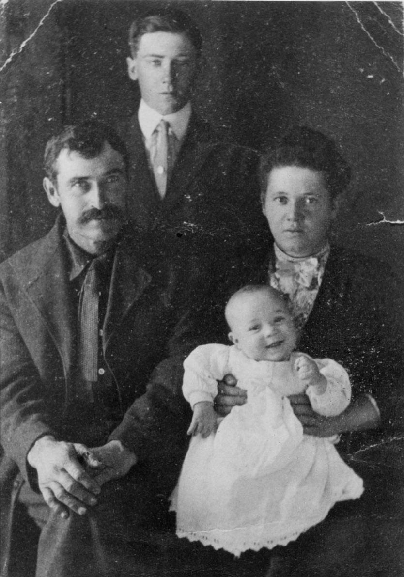
The William and Sarah Kesler family, circa 1908. Clockwise: Otto Kesler, Sarah Adeline Losee Kesler, Arlo Kesler, and William Henry Kesler. Courtesy LeGrande Davies
UHQ 90_2 Text.indd 94 4/8/22 1:36 PM
of the site’s significance and hoped to preserve its history. Incidentally, these themes were also present in my interview with LeGrande Davies, suggesting a significant correlation between the two versions. Davies contributed further detail to the William Henry story, most of which he likely learned from his grandfather, Otto Kesler. This additional information speaks to William Henry’s inventiveness and ability to create a life for his family at Cove Fort. Finally, Otto recalled a Native American presence at Cove Fort that persisted through the twentieth century. The Kesler family’s interactions with Native Americans seem to have occurred in a quiet, almost subtle way. Yet as will be discussed in greater detail later, tropes from the mythic Old West undoubtedly influenced how visitors stopping for gasoline and a quick tour experienced Cove Fort’s history.
Otto Kesler explained to Porter that after the Hinckleys moved away from Cove Fort, the church leased the fort to a number of individuals. A fire caused by one of the tenants destroyed Cove Fort’s north side, leaving the fort unoccupied and virtually unlivable. Previous tenants and campers had used the surviving south side to stable horses and cows.10 “You can imagine what a place, how it goes when nobody’s lived around there for two or three years,” Otto observed in the interview.11 It was in these conditions—a charred, broken wreck—that William Henry Kesler found Cove Fort in June 1903. Kesler and some other men from Beaver, Utah, stayed briefly at the fort that summer on their way to Kimberly, Utah, where they had a contract to cut and deliver cord wood for mines.
Born in Saint Thomas, Nevada, to Joseph and Anne Pitts Kesler in 1868, William Henry was a month shy of his thirty-sixth birthday. As Davies observed in his interview, William Henry’s life had not been an easy one. Kesler married his first wife, Annie Edwards, in 1893. She died nine months later, shortly after giving birth to their first child. He married again in 1894 to Sarah Adeline Losee. Babies came quickly and, by 1903, their family had grown to include four children.12 William Henry led a hardscrabble life, picking up work where he could find it.13 He undoubtedly saw Cove Fort and the surrounding land as an opportunity to at last settle and create a stable life for himself and his growing family.
Once the contract with the Kimberly mines was completed, William Henry made a trip to Salt Lake City to inquire about leasing Cove Fort from the church in December 1903. Successful in this endeavor, Kesler spent the early spring of 1904 making the fort habitable. On April 25, 1904, shortly after Sarah had given birth to their fifth child, the Keslers moved from their home in Beaver to Cove Fort. Nineyear-old Otto remembered the day well. He and his younger brother Ferrell rode horses and pushed cows. William Henry drove a wagon loaded with furniture and supplies. When the young family crested Pine Creek Hill, they paused momentarily in the afternoon sun as William Henry pointed out Cove Fort, far off in the distance. “It seemed like it took us a long while to get from the top of that hill over that draw with those slow cows.”14
According to Otto Kesler, when the family first arrived, some alfalfa still grew sporadically in the fields east of Cove Fort, across the wagon road. William Henry replanted this field in alfalfa or “young Lucerne,” restoring it to “hay ground.” Otto clarified, “On the west side [of Cove Fort], he got that back into hay again. . . . But the first he got into hay was on the east side of the road—the twelve acres on the east side.” William Henry also planted apple trees, English currants, and gooseberries.15 The Keslers made ready use of Cove Fort’s existing outbuildings and structures. The original round corral served the family well into the 1930s; the barn remained in use until the state widened Highway 91 in the early 1940s.16 Otto indicated that plans for the widened road ran near where the barn sat, necessitating its removal. By that time, however, the barn was too old to be of much use. “It’d leak so much . . . and the timber’s getting old and that, it was getting kind of dangerous—these big winds, it was pretty hard on it.”17 Otto remembered the barn’s four windows nestled high under each gable, a perfect vantage point from which to see the small valley in its entirety. “You could look east and you’d look north and west and south.”18 During this time the fort also became a switchboard for the first telephone line between Beaver and the rest of Millard County. For power, William Henry rigged a direct current wind generator on Cove Fort’s south wall. The Keslers also used a gasoline generator until 1941, when the
95 UHQ I VOL. 90 I NO. 2
UHQ 90_2 Text.indd 95 4/8/22 1:36 PM
family dug and installed power poles and connected their own line with Telluride Power Company to the east in Richfield.19
William Henry Kesler continued to lease Cove Fort until 1911, when he convinced the church to sell it to him outright. He paid $8,500 for it and eight hundred surrounding acres but did not obtain a clear title until 1919.20 Initially the family lived in the fort’s south side until 1917, when Kesler was able to hire brothers Martin Henry Hanson and Lorenzo (Ren) Hanson from Fillmore to help him rebuild the burnedout north side.21 Otto emphasized,

My father had [the north side] rebuilt . . . because he always said that . . . there’d be a time coming when that fort would be worth more than the whole ranch because he wanted to restore it and maintain it so’s it would stand for generations to come for people to see. He knew that there’d been nearly a hundred forts built in the territory of Utah . . . and they were about diminished and destroyed by that time. . So that is one reason for him to build the north side up just like it was and to maintain it and take care of it like he did.22
For at least the first few years, it appears the family all lived at Cove Fort year round. Birth information suggests that between 1907 and 1911, three of William Henry and Sarah Adeline’s eleven children were born at Cove Fort.
The remaining children were born either in Kanosh or Fillmore.23 Oral history testimony from Otto Kesler bears this out. Otto notes that William Henry hired a teacher for his children during the wintertime. This continued until Otto was in the seventh grade, when he attended school in Beaver, eventually graduating from Murdoch Academy.24 According to LeGrande Davies, Otto also attended some primary grades in Kanosh, staying with families there during the week and then riding home to Cove Fort on Friday night. William Henry Kesler eventually purchased a home in Fillmore and at least for part of the year mother and children lived there.25
The land produced well as long as the Keslers could get water to it and the growing season cooperated. My interview with LeGrande Davies highlights William Henry Kesler’s ingenuity and creativity. William Henry rerouted Cove Creek and created irrigation ditches by using a bowl of water as a leveler. He walked slowly and carefully over the land, gaging the grade by how the water tilted and lapped at the bowl’s edge. The ditches he cut curved like snakes, but with them the family was able to irrigate between 180 to 360 acres, generally alfalfa. Kesler also diverted some of the water from Cove Creek so that it ran through the fort’s east gate via a pipe with a filter box full of sand, gravel, and charcoal. The water then collected into a cistern dug into the center of the courtyard. He kept the water fresh by adding lime and by periodically scouring the cistern. Drinking water, however, came from a seep spring about a mile-and-a-half east of the
96 UHQ I VOL. 90 I NO. 2
UHQ 90_2 Text.indd 96 4/8/22 1:36 PM
An early photograph of Cove Fort, about 1910. Note William Henry Kesler’s wind generator on top of the fort. Courtesy LeGrande Davies
fort. Water from the spring had to be hauled by wagon in barrels until the 1930s, when the family installed old steam piping from the mines in Kimberly to bring potable water into the fort.26 This proved to be only a partial solution, however, as the pipe often froze. Finally, around 1960 the Keslers improved a well, dug in the 1930s east of the fort, and installed a submersible pump and plastic pipes, buried deep underground to prevent freezing.27
The Keslers were also conscious of the local Native American population and their connection to Cove Fort. Otto remembered that bands often traveled through the area and camped near the fort. “They used to get these elderberries . . . in the fall here and get the juice out of them.” Other times bands passed through on their way to Indian Peaks to gather pine nuts. “The Cedar Indians used to come over to Kanosh and they had big celebrations. . . . And that’s how we’d get to see quite a few of them there at the crossroads.” Although Otto stated that his parents generously provided these travelers with food and feed for their livestock, the Indians scared him. “I had heard so many stories about them, you know.” Despite his fears, he was obviously curious and observed their camps closely, watching as band members cooked rabbit meat in a traditional way and baked bread using skillets. One frequent traveler through the area was a Pahvant man known as Hunkup. Hunkup was well known to the white community; every once in a while, a newspaper article mentioned his activities, often describing him in disparaging and racialized terms.28 Full of youthful bravado, Otto once approached Hunkup while he was camping at Cove Fort. “He had his little fire and getting his dinner and I says to him, I felt pretty big, I says to him, ‘Hunkup, you used to be pretty mean to the white men, didn’t you? You Indians.’ ‘Ah,’ he says, ‘lad, you don’t know what you’re talking about.’ He says, ‘White man used to be pretty bad [to] Indian, too.’ So that started me to thinking that maybe the white men was about as bad as they was.”29
Although Hunkup successfully challenged Otto’s assumptions in a way he never forgot, for modern readers, this story may contain troubling elements. In retelling the incident, Otto only conceded that Euro-American settlers were “about as bad” as Native Americans. More may be at play here, however. In one short
retelling, Kesler ably communicated the long and difficult relationship that formed between Mormon pioneer settlers and the Indigenous people of central Utah. The memory these interactions left on both peoples is palpably present in this experience. Earlier in his narrative, Otto remarked that he feared Indians because of the stories he had heard about them. He did not elaborate on the kind or nature of these stories. Were these popular stories about the mythic Old West or ones about the Black Hawk War passed on to him from trusted adults? As Paul Reeve observed, messaging from church leaders cast neighboring Paiute bands within enduring Book of Mormon narratives. As Lamanites, the thinking went, Paiutes were members of the House of Israel, who needed reclaiming. At the same time, some believed Paiutes descended from the Book of Mormon group the Gadianton Robbers, making them a feared and dangerous people. Yet even during the Black Hawk War, military action was sometimes offset by overtures of peace. As Reeve explained, by the century’s end, power dynamics undeniably favored Mormon settlers. Yet at the same time, the Paiutes had become integrated into Mormon frontier life in ways that insured a significant degree of familiarity between the two peoples, something Otto Kesler’s exchange with Hunkup bears out.30 Otto’s relationship with Paiutes continued into adulthood, when he both employed them at Cove Fort and purchased their handmade deerskin gloves to sell in his store.
By the 1920s, a heightened interest existed nationwide in relating and preserving the frontier experiences of white, northern European pioneer settlers. The historian John Bodnar attributed this awareness to revolutionary social changes that transpired during the first decades of the twentieth century. People adapted to these changes by creating a historical narrative that established and strengthened a cohesive community identity. “The heroes of their cultural construction were not signers of the Declaration of Independence but ordinary people. They were the ‘pioneers’ who first settled the prairie.” Across the Midwest, for instance, Old Settler Associations formed, sponsoring picnics and other events designed to commemorate those who came before. Bodnar explained that these societies glorified Euro-American pioneers as “nation builders, conservators of
97 UHQ I VOL. 90 I NO. 2
UHQ 90_2 Text.indd 97 4/8/22 1:36 PM
tradition, and models of survival during difficult times.” Moreover, the conquered land itself became an important physical witness to the pioneers’ hardy ingenuity and resolve.31 In Utah this drive manifested itself in the founding of the Daughters and Sons of Utah Pioneers, organized in 1925 and 1928 respectively. These groups set out to gather histories and otherwise memorialize events and places significant to the Mormon pioneer experience.32
Further afield, automobile clubs and other local boosters lobbied for better roads in the hopes of building Utah’s nascent tourism industry. They dubbed the highway that passed in front of Cove Fort the “Arrowhead Trail,” one of several main routes to southern Utah’s splendors.33 This phenomenon was not unique to Utah. By the early twentieth century, an emerging automobile culture accompanied by a growth in leisure time largely replaced elaborate railroad tours and exclusive wilderness retreats for the wealthy. Targeted boosterism established the West as the nation’s playground in the form of national parks and resort towns. History, or at least the mythic variety, became a selling point, celebrating Euro-American conquest in starkly racialized terms.34 Knott’s Berry Farm, for instance, originated as a berry stand during the 1930s where Cordelia Knott treated travelers to her famous chicken dinners as a way to make extra money. In 1940, her husband Walter purchased the Mojave Desert ghost town of Calico and resituated it in Buena Park. A decade or so later the new “mining town” had evolved into a a 40-acre Old West theme park.35
Not unlike Walter Knott, although on a much lesser scale, William Henry Kesler also
capitalized on automobile traffic and promoted Cove Fort as a historic site. Although it is not known when these efforts began, an October 1916 Salt Lake Tribune article alerted travelers that they could find a “telephone, gas and oil” at the fort. The short blurb continued, “Note— This is one of the pioneer monuments of Utah, built by Brigham Young as a protection against the Indians. It is worthwhile to stop and examine.”36 Frank Beckwith, owner of the Millard County Chronicle and an important booster for the area, took an interest in the region’s local history.37 In an article for the Improvement Era, Beckwith recalled dropping in at Cove Fort for a drink and hearing about the fort’s history, presumably from William Henry’s wife, Sarah. “What a fine, wholesome, quiet air the old place had!” he recalled. “There was a wash on the line within, a peep of which I had through the open doorway, lending it a really homey background. And better yet . . . two innocent little lambs, just learning the use of those wobbly legs of theirs, emerged timidly through the big portal.” Beckwith learned the fort had been built in 1867 under the direction of Ira N. Hinckley as a protection against Indians but was never attacked. “I listened with interest to her recital that the place was used for years as a stage station in the long ago; also that boy riders carried mail from Beaver to Fillmore, stopping there for change of mount.” Beckwith added, “To linger was a pleasure.”38
The family initially pumped gas from fifty-gallon barrels, which they hauled from the railroad station at Black Rock. Eventually they installed an underground tank and hand pump along with a makeshift concession stand next to the fort. (Later, Otto Kesler operated a store
98 UHQ I VOL. 90 I NO. 2
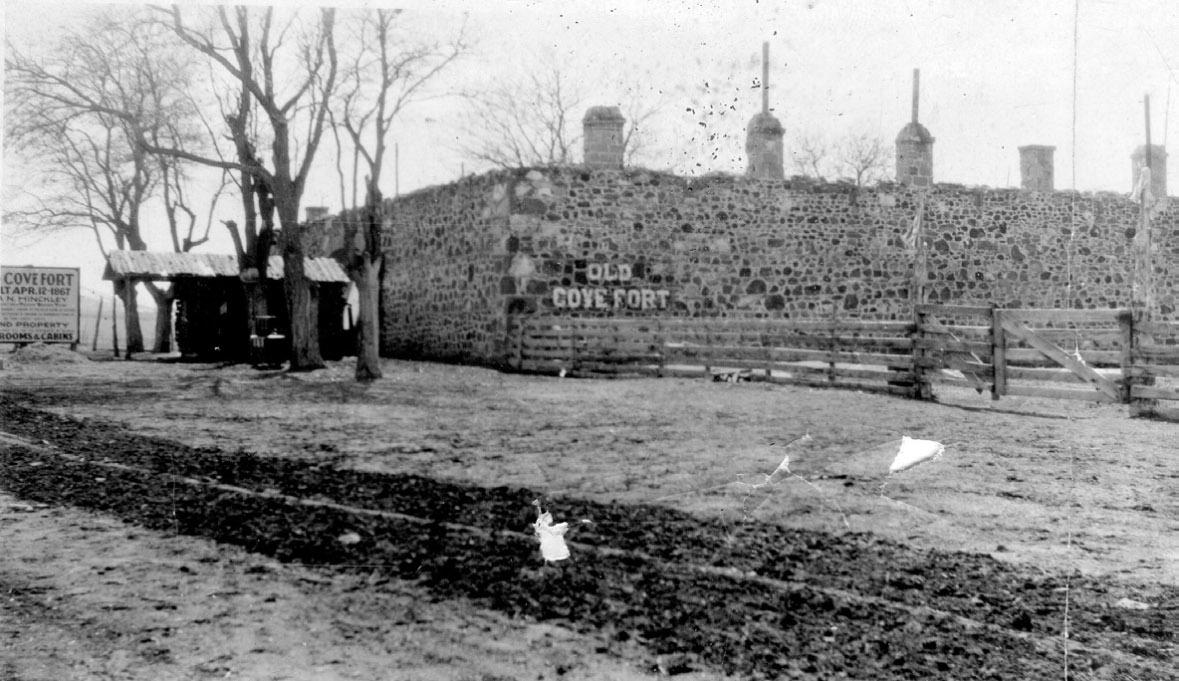
Cove Fort, circa early 1900s. Note the store in front of the fort and signage on the side. Courtesy LeGrande Davies
UHQ 90_2 Text.indd 98 4/8/22 1:36 PM
and Texaco service station across from Cove Fort on the east side of Highway 91.)39 People who needed to spend the night at Cove Fort simply pulled their automobiles into the courtyard. The Keslers partitioned the original assembly room (on the south side) into a kitchen and dining area and reserved a few rooms for travelers. William Henry later constructed additional small cabins east of the fort to accommodate more travelers.40 The family also helped automobilists and others stranded on the road running through Cove Fort country. In an oral history interview, Otto shared several harrowing experiences. “I remember one time, they brought a man and two boys in there. Their ears just a-black ends. They had frost sticking out on them.” Instead of bringing the family in by the stoves to get warm, the Keslers gave them a snow bath. “They put snow on their ears, and put their feet in snow and their hands and everything. Rubbed snow all over their faces and gosh, the frost just come out of their ears.”41
Located along a major highway, Cove Fort quickly attracted the attention of preservationists. There is evidence that as early as 1921 citizen groups tried to persuade the legislature to designate the fort as a state park.42 Efforts to these ends intensified after F. B. McCombe purchased Cove Fort from the Keslers in 1926. Originally from Oklahoma, McCombe and his son had grand designs to turn Cove Fort into a dude ranch, replete with a swimming pool and interior dance floor.43 It is not clear why William Henry Kesler sold the fort, but some found McCombe’s crass commercialism offensive.
“The old ever gives way to the new,” Beckwith cynically observed in his 1927 Improvement Era article: “Cherished landmarks of any region, one by one, are replaced or changed by the onward march of progress—and not always by way of betterment.” He went on to elaborate,
Historic “Old Cove Fort” is now a “Dude Ranch!” Alongside those ancient walls is now a gas station, a hideous thing of galvanized iron, and stalls to display wares for the camper. Nailed upon the very stones (that but for them would breathe a spirit of deepest sentiment) are now gaudy road signs, screeching with raucous voice a message to the autoist. A huge
sign tells you it is a “Camping Station.” But, you have to hunt, in neglect, in weathered paint growing dim, to find the words which bring into being every fondest remembrance of the place—Old Cove Fort.44
In order to both preserve Cove Fort’s history and create a tourist destination, civic groups and highway boosters erected a monument commemorating the Black Hawk War and the fort’s sixtieth anniversary in April 1927. W. O. Cluff of the Richfield Commercial Club presided over the dedication festivities, which included remarks by Heber J. Grant, then president of the Church of Jesus Christ of Latter-day Saints, and Ira N. Hinckley’s sons, Bryant, Edwin, and Arza. Despite the fact that the fort had never known armed conflict, locals treated the gathered crowd to a “sham battle for the possession of the fort, executed between a group of cowboys representing the Indians and attacking the fort, and the Richfield battery defending it.”45 A few months later, however, the McCombs left Cove Fort, leasing it to J. M. Perkins and W. R. Monroe, both of whom were involved in Sulphur, Utah, mining. Perkins and Monroe planned to continue running Cove Fort as a resort, but by January 1929, they, too, left and the Keslers repossessed the fort.46
When William Henry Kesler reacquired Cove Fort, he set out to establish it as a historic site, most likely playing to increased automobile traffic and commercial club interest in selling southern Utah as a tourist destination. He spent time locating artifacts and memorabilia visitors might find interesting—guns predating the Civil War and an impressive saddle and coin collection.47 He constructed a small outbuilding near Cove Fort to house these curiosities, calling it “the museum.” He also purchased a Studebaker borax wagon from Death Valley and parked it in the fort’s courtyard.48 Kesler made his most significant find in 1930 when Ira Edward McMullin, an LDS bishop in Leeds, Utah, contacted him with an enticing offer. The Leeds congregation was in the process of constructing a new meetinghouse and wanted to replace its bell. McMullin had learned that a local hardware dealer had recently sold Cove Fort such a bell. Would William Henry trade his new bell for the old one? A load of fruit would be thrown in to cement the deal—after all, the Leeds Ward bell was not just
99 UHQ I VOL. 90 I NO. 2
UHQ 90_2 Text.indd 99 4/8/22 1:36 PM
any bell. According to tradition, it had served as the dinner bell for federal troops (Johnston’s Army) who came to the territory as part of the Utah War. In 1861, when Union Army Colonel Patrick Connor arrived in Utah, he took the bell and cannon from Camp Floyd and installed them at Camp Douglas (later Fort Douglas). Sometime in 1877, a few daring Mormons made off with both bell and cannon. Concealed in a load of grain, the bell found its way to the Leeds meetinghouse. With a reported provenance like that, William Henry could hardly resist, and the dinner bell has been in the Kesler family’s possession ever since.49
In 1934, shortly after Kesler acquired the famed bell, the Utah Pioneer Trails and Landmarks Association was the last organization to encourage the establishment of a state park at Cove Fort.50 The Daughters of Utah Pioneers joined this effort after unveiling one of its historic markers at the fort in 1935. When the state legislature failed to appropriate the necessary funds to purchase Cove Fort, the Landmarks association offered to buy the fort for $8,500, provided the federal government would make it into a national monument.51 Nothing more came of this effort, however, and the Keslers remained at Cove Fort. It was during these years that Otto bought Cove Fort from his father, paying his other siblings for their shares after William Henry died in 1947.52
In many respects, Otto Kesler was Cove Fort. He grew up at the fort and lived there almost continuously from the time his family first arrived in April 1904 to his death in 1966. The history from this period comes primarily from interviews and conversations with LeGrande Davies, who has many fond memories of his grandfather Kesler. In these recollections, Otto acquires almost mythic proportions. He is razor smart, deeply fair, and honest to a fault. Otto’s ability to read and manage the land figure prominently in these interviews as do the relationships he forged with the Paiute band at Kanosh.
In 1916, Otto married Mary Yardley and had a son, William Kesler, in 1917. Tragedy struck the young family in November 1918, when both Otto and Mary contracted Spanish influenza. Mary died later that month at Beaver; Otto was so ill that he was unable to attend her funeral.53
Two years later in 1920, he married again to Alice Thomas. In a span of ten years, between 1921 and 1931, they had five children: Mary Loree, David Otto, Joseph Frederick, Marion Leon, and Calvin Thomas. Two of these children, Mary and David, were born at Cove Fort; the others were born in Greenville or Fillmore.54 Like his father, Otto later kept a home in Fillmore so his children could attend school, but during summers, the family spent most of their time at Cove Fort. Kesler raised cattle, meat hogs, and sheep and acquired additional acreage near Milford and Kanosh.55 By the 1950s, Otto left the day-to-day operation of these farms to his sons. An accident he sustained years earlier while working at a Sulfphurdale mine made it impossible for him to ride a horse in his later years. Instead, Otto spent his time keeping the service station at Cove Fort. “It was very frustrating to him, I think, that he wasn’t able to physically get out and do everything,” LeGrande Davies later reflected.56
Otto’s two sons, Calvin and David, along with their wives Faye and Helen, moved into Cove Fort, occupying the six rooms along the fort’s
100 UHQ I VOL. 90 I NO. 2
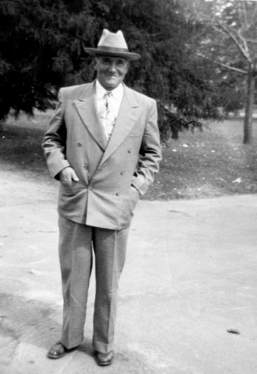
Otto Kesler, 1964. Courtesy LeGrande Davies.
UHQ 90_2 Text.indd 100 4/8/22 1:36 PM
north side. Each family had a bedroom, front room, and a kitchen. A partitioned-off corner in each kitchen functioned as a small bathroom and shower. Tourists who stopped at Cove Fort never fully realized the historic site functioned first as a home. “People would come in—they’d just open the door and walk in on you. And they’d say, ‘Oh! We didn’t know anybody lived here,’” Davies remembered.57
Cove Fort not only bound the Keslers to the land but also linked them with earlier generations of Mormon settlers and pioneers through the common experience of hard work. At five years old, LeGrande Davies steered a hay truck while men loaded bales. “The truck, basically got into the furrows and it kind of stayed there. But my job was to make sure that it didn’t run over any bales. When we would get to the end of going down a row . then my job was to jump down, step on the clutch, and push up as hard as I could on the steering wheel and hold it there until one of them could come in and kick the truck out of gear.” Most importantly, at the end of the summer, Davies lined up with the others to receive his pay—a check for two dollars signed by Otto Kesler. The next year he worked with his uncles, learning how to push cows, keeping them out of roadways, and moving them to different rangeland and water sources. “The year I was seven . is the year I had to catch my own horse, I had to saddle my own horse, and then I started driving cows, driving them out of the lanes. . . . Me and the dogs and the horse.” All alone he drove the cows fifteen to twenty miles a day to new feed and water. “Didn’t do a lot with the hay after that. They got a side loader. . . . But I liked the horses and cattle better.”58 The added responsibilities gave Davies a sense of satisfaction. “I was proud of the fact that I could ride. I was proud of the fact that I could break horses. And it was interesting that my uncles became very proud of that same thing.”59 Experiences like these continued a tradition that reflects preindustrial times. As the labor historian Chaim Rosenberg writes, “A farmer could not afford much hired help but depended on his wife and children to help with the farm work. One farmer said, ‘Every boy born into a farm family was worth a thousand dollars.’” Because child labor reformers saw agricultural work as beneficial for children, especially boys, instilling in them the value of honest labor, discipline, and thrift,
few questioned the health or safety risks these activities posed.60 Davies views his childhood at Cove Fort in a similar light.
Most importantly, working at Cove Fort allowed Davies to spend hours with his grandfather, developing a special bond between them. In oral history interviews, he often reflected on his grandfather’s many abilities. “He had a gift for dealing with horses that I had never seen with anybody. . . . Seeing just what he did with them, even in his crippled state, was amazing to me. . . . My grandfather could talk to them and they were just as calm as could be when he was working with them and when he was around them.”61 According to Davies, Otto was a quiet man, known for his photographic memory and strict honesty. “You ask him about a date or a time or an event and he gave it to you exactly. . He gave it to you as he had seen it. He was a man who was honest and straightforward and everything to him was black and white.” Davies continues, “He memorized things like you wouldn’t believe. . . . He had a mind like a steel trap.”62
It was from his grandfather, too, that Davies learned to love and respect the land. “Cove Fort—it’s rugged country. It’s hard on people,” he observed. “That land’s a desert. But it produces and it produces a lot if you don’t take too much at a time. But you have to take from it. If you don’t, it doesn’t produce as much.” The Keslers survived as well as they did because William Henry and Otto Kesler and their families learned the cadences of the land. “They were very observant with what they were doing. They watched carefully. My grandfather . watched things and he was able to tell when something was working and when something wasn’t. He was able to watch the balances of things.” Otto’s prodigious memory certainly helped. Coming to Cove Fort as a child, he remembered almost everything the family did to the land. He often shared this information in passing to those who would take the time to listen.63 For years, Otto took daily temperature readings for the United States Weather Bureau. He remembered the drought times when, with little to no irrigation, gophers burrowed through the dried-out fields, clipping the roots and destroying the remaining crop. At other times, the ground became alive with hordes of black crickets, marching and devouring every green thing in sight. “They come across the
101 UHQ I VOL. 90 I NO. 2
UHQ 90_2 Text.indd 101 4/8/22 1:36 PM
fields, they come, just didn’t go around the Fort, they just climb over it and down the walls and over and over the walls and right on, just kept a-going,” Otto recalled.64
The Keslers quickly found that for the land to produce at its optimum, it had to be both grazed and farmed. An article for the Utah Farmer explains the process the Keslers used for managing the land. “Since the area is high and frosts occasionally are destructive, [Otto] Kesler and his family have learned how to meet this hazard.” The article continues, “Strange as it may seem, a large herd of beef cattle is the answer, for if a late spring frost hits the dry farm grain just as it is coming into the boot, the hard-bitten grain fields are immediately turned into beef pastures and the grain utilized for cattle feed.”65 The Keslers also found feed for their cattle in seemingly impossible places, like the shadscale and sagebrush ranges west of Cove Fort. “Had a USU guy once come and told us that you couldn’t raise cattle on shadscale,” Davies remembered. “So my granddad suggested that I take him out for a ride and show him. I think I was about fourteen, fifteen. Didn’t have my driver’s license yet, but I drove him out. And we went and watched them eat the shadscale and he was dumfounded.”66 In the wintertime, cattle fed on sagebrush. “We would pick an area where sagebrush was becoming too much . . . and then we mixed cotton seed meal and salt together . . . and it made the cows exceptionally hungry. And what we would do was we’d feed them enough hay to not completely fill them up, but to give them enough . . . energy . . . and the cotton seed meal also helped to give them the vitamins. . . . But then they’d start to eating sagebrush. . . . And our cattle would winter really, really well,” Davies explains, adding, “I don’t know that a lot of people could survive . . . wintering cattle in that area.”67 The Keslers always watched the carrying capacity of the land and kept their cattle herds under 250 head. “It’s the people that were careful that finally ended up with the land. The others would overgraze. They’d go in debt and they’d get all these extra cows and then they’d go broke,” LeGrande observed.68
The Keslers utilized the land in other ways. Like those who came before them, they often bred their mares and then turned them out
onto the range where they would foal. They caught and broke a horse when they needed one. Volcanic lava flow, ash, and cinders break up the range southwest of Cove Fort. “Those horses would run on those lava flows. Running across all that rock all the time, they ended up with the hardest hooves you could imagine,” Davies noted. “It made their hooves extremely hard and it made them perfectly shaped. We never had any problems with horses with broken hooves or horses with chipping hooves.”69
In the end, Davies believes his grandfather inherited the land because he valued it the most. “I think all of his other brothers wanted to go someplace else.” On summer evenings LeGrande loved to sit with his grandfather, watching the sun melt into the hills west of Cove Fort, together savoring the stillness that enveloped the land. “There was a group of coyotes that used to sing out there. Grandpa would always say, ‘Ah. Can’t they sing well. Can’t they sing well.’ There was a peacefulness that would come because the wind quits blowing in the evening.”70
Outside of the Kesler family and other hired help, members of the Paiute band at Kanosh formed an important labor force. Davies remembered them only in terms of family:
The Paiutes that worked for us, that worked for us when I was young, they would come and work with my grandmother in the kitchen and help . . . her clean, they helped her with washing. They were given room and board. They ate with the family when we ate, their kids . . . we’d played around together a lot. . . . The husbands, the males would work out on the farm. They plowed; they worked side by side with us.
“They didn’t get the dirty jobs any more than anybody else got the dirty jobs,” He stresses. “Everybody got the same dirty jobs. You had to dig a cesspool, why everybody got a chance to work in it. . . . They held down calves. They worked with cows when we were doing that. They plowed, they drove tractors, they hauled hay, they were part of the family.”
Throughout this interview segment, Davies was careful to emphasize Paiute cleanliness,
102 UHQ I VOL. 90 I NO. 2
UHQ 90_2 Text.indd 102 4/8/22 1:36 PM
perhaps as a way to counter common racial prejudices he may have heard growing up. “My grandmother, she would have never allowed somebody in the kitchen who wasn’t clean. That meant you had to wash your hands. These women were clean women. They knew how to cook.” Davies continued, Bell was really, she was a great cook. And I mean, a really, really good cook. She cooked traditional Indian foods. . . . [She] was one of the ladies that worked with my grandmother. . . . I don’t know how she got the name Bell. I’ve forgotten what her Indian name is. That’s awful because I knew it. But I forgot what it was. Her husband was a medicine man [Wes]. He traveled around through the western part of Utah and Nevada and up into Idaho, and so on, blessing people and marrying people and going about. He was a well-thought-of man. But we stayed pretty close as families. We were really good friends.
He concluded, “They weren’t ‘dirty Indians.’ They were people. And they were treated as people. I don’t know. That’s always the way I saw it, anyway.”71
Work by the ethnohistorian Martha Knack reveals that the Keslers’s use of Paiute wage labor reflects a much longer history that was characteristic of Mormon-Paiute relationships stretching back into the nineteenth century. It was not uncommon for Paiute men to be employed as temporary farm workers; women often worked as domestics. Indeed, Great Basin tribal groups shifted into this kind of wage labor early on, especially once Mormon settlers dominated food and water resources. Knack cited one Indian agent who, observing in the 1870s, noted that Mormons living in St. George employed Paiutes from the Shivwit band. “Some of the men are excellent cowboys, and have work much of the time with neighboring cattlemen, while others hoe and do other small chores,” the agent reported. Davies’s assertions of familial relationships notwithstanding, in general, Native workers were paid significantly less than whites and were only employed in unskilled or semiskilled work.72
Finally, Otto Kesler continued to operate Cove Fort as a way station, helping countless individuals hard on their luck, especially the “footmen,” homeless men who trod the highway’s dusty shoulder. Whenever Kesler saw them coming, he sent LeGrande out with some Spam, a loaf of bread, or other canned goods
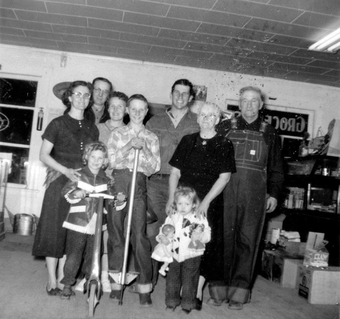
Inside the store at Cove Fort, Christmas 1957. Top row, l–r: Mary Kesler Davies, A. LeGrande Davies, Faye Kesler, LeGrande K. Davies, Calvin Kesler, Alice Kesler, and Otto Kesler. Front row, l–r: Pamela and LaNila Kesler (children of Calvin and Faye Kesler). Courtesy LeGrande Davies
103 UHQ I VOL. 90 I NO. 2
UHQ 90_2 Text.indd 103 4/8/22 1:36 PM
from the store. These he strategically placed in nearby garbage cans for the men to find. Other times the Keslers offered temporary employment and a place to stay.73 One night they very likely helped save a man’s life. A police officer found Bernard Bee half frozen in a blizzard and brought him to Otto’s service station where Bernard polished off a jar of peanut butter, one spoonful at a time. He made it clear he was no charity case, however. He’d work for his supper.74 Bee became an integral part of Cove Fort and the Kesler family. He loved to fix fences and construct outbuildings and sheds. He had worked in a circus and had a stepfather who often beat him, leaving him with a shrunken, misshaped head and a back riddled with scars and lashes. Bee stayed with the Keslers twenty-four years. When Davies left on his mission for the Church of Jesus Christ of Latter-day Saints, he gave Bee his World War II bomber jacket. “It was made out of sheepskin and stuff. And he used that. He used that for so many years until he totally wore it out. They finally had to buy him another one. . . . He’s buried in Beaver next to my Uncle Joe.”75
The way of life the Keslers enjoyed at Cove Fort nearly ended when Utah received approval for a new interstate highway in 1957. The proposed route connected the interstate out of Denver with Highway 91 just south of Cove Fort.76 No one was more pleased about the news than Otto Kesler. “Yes sir, this is going to be quite a place when they build the highway,” he told the Associated Press that fall.77 Yet what initially appeared to be a boon almost cost the family the fort. Both in oral history interviews and documentary material that detail this period, Otto Kesler emerges as a proverbial underdog, fighting not only to maintain ownership of his fort, but to preserve a way of life for his family and the foundational ties to the past that went with it.
In the years following World War II, Utah vied with other western states for its share of tourist traffic. A 1958 study by the University of Utah’s Bureau of Economic and Business Research found that 85 percent of Utah’s tourists came to the state by car. Of those, an estimated onethird were Californians.78 The report confirmed what many already suspected: Cove Fort, situated as it was along Highway 91 and now near
a proposed interstate highway exchange, was prime real estate. Early that same year, officials offered the Kesler family $40,000 for the fort and ten surrounding acres with hopes of turning the property into a state historic site. Otto Kesler had no intention of selling—especially at such a low price. In response, the state began condemnation proceedings in July, hoping to secure the property through right of eminent domain.79
The following June of 1959, court proceedings took place in Fillmore. LeGrande Davies remembers the summer well. At fourteen, he stayed at the fort while his parents, grandfather, and uncles traded off attending the trial and working the farm and station. Every evening when they returned from court, Davies listened to the adults long into the night animatedly discussing the case. “I remember . my grandfather a few times coming back home . . . he was so angry about things he would just shake all over.”80 Mark Paxton, who supplied the Kesler’s Texaco station, served as a star witnesses in the case. Paxton conducted a traffic count on a Sunday morning between 9:35 and 11:35 a.m. During that time 515 vehicles passed by Cove Fort, ninety-one stopped, and 335 people visited the fort. Paxton suggested in light of the current interest in Cove Fort, the state should pay the Keslers at least $190,000. After five days of trial, the jury valued Cove Fort at $70,000, without any land except that which the fort sat on. The Keslers were not in the clear yet, however. Nor were they about to accept the new value. Fifth District Court Judge Will Hoyt, on the other hand, recommended the state appeal the case, believing the award was “excessive” and that the jurors “‘were influenced by testimony based upon speculation and upon assumptions of fact not proved by competent evidences.’” The state attorney general, Walter Budge, suggested otherwise, noting the undue burden such an action would place on taxpayers. Public opinion also swung in favor of the Keslers. In an editorial titled “A Vulture Waits,” the Springville Herald criticized, “This case, we believe, is like many others where the law of eminent domain is exercised too far giving the individual few, if any, rights to his own property.” The Salt Lake Tribune took a more measured stance, observing, “Considering the divergence of opinion as to the value of the
104 UHQ I VOL. 90 I NO. 2
UHQ 90_2 Text.indd 104 4/8/22 1:36 PM
property, the feeling engendered by the efforts to turn a private enterprise into a public one by court action, and the growing demand for use of state funds on other projects, the park commission might well reconsider this matter.” The Tribune concluded, “We suggest that the park commission concentrate on more urgent sites, meantime keeping an eye on Cove Fort and continuing efforts to negotiate for purchase when conditions are more favorable.” The state conceded and dropped the suit in September 1959.81
Following the court case, Otto Kelser decided to restore Cove Fort and convert it into a museum. The state suit and the threat of losing Cove Fort for good certainly contributed to his decision. In 1959, John Riley worked on the fort’s south side, using plaster, flooring, and shake shingles that matched the original. The Keslers had not occupied the fort’s south side since World War II when, because of the scarcity of metal granaries, they used it to store grain as part of the federal Hot Wheat program.82 “All window sills . doors, and casings are the original, with many of the wooden pegs still used, rather than nails,” the Beaver Press observed. Two years later the George Brothers

construction company restored the north side, which had long served as living quarters for the Kesler family. In the meantime, Otto’s daughter and son-in-law, Mary and A. LeGrande Davies, along with Calvin and Joe and their wives, Faye and Carol, located many of the objects for the museum. Instead of seeking artifacts directly associated with Ira N. Hinckley, as the Church of Jesus Christ of Latter-day Saints did in their restoration years later, the Keslers acquired and displayed objects from the families who helped construct the fort: head mason Nicholas Paul’s trumpet and organ, a walnut bed from the Robison family, a dresser from the Warners, rugs, and other antiques. These objects told an important story that emphasized the history of Cove Fort’s builders and the region as a whole.83
LeGande Davies, then in high school, wrote a short pamphlet for distribution that detailed the fort’s history. Entitled “Brigham Young’s Old Cove Fort,” the pamphlet demonstrates how the family thought about historic site interpretation and gives an insight into the narrative they crafted and shared with tourists. Davies’s pamphlet includes brief sections on Wilden Fort, a structure that predated Cove Fort’s construction; the Black Hawk War; and
105 UHQ I VOL. 90 I NO. 2
UHQ 90_2 Text.indd 105 4/8/22 1:36 PM
Tourists at Cove Fort, late 1950s or early 1960s. Note William Henry Kesler’s cistern in the center of the courtyard and a child climbing on the wagon. Courtesy LeGrande Davies.
Young’s decision to construct a fort in the area initially as a protection against Native Americans, later as a way station for travelers. Ira N. Hinckley, incidentally, receives only a brief mention. The bulk of the pamphlet discusses Cove Fort’s architectural features and closes with the arrival of the Kesler family.84 This emphasis on architecture likewise figures prominently in oral history interviews with Otto Kesler. Even today, the fort’s physical features come up often in conversations with LeGrande Davies.85 Through their experiences of living at the fort, the Keslers seem to have acquired an intimacy with the physical place that directly contributed to their sense of responsibility for Cove Fort and its history.
The operating season for the Cove Fort “museum” ran from March through October. The Keslers charged fifty cents for adults and twenty-five cents for children to see the fort, literally making hundreds of dollars every day—mostly loose change and silver dollars from Las Vegas slot machines. Every night they counted the money and took it to the bank. As part of the 1959 to 1960 restoration, the family converted one of the north side rooms into a small souvenir gift shop that the Kesler women stocked and managed. They often engaged visitors in conversations about the Church of Jesus Christ of Latter-day Saints. Turning in countless missionary referrals, they sold or gave away copies of the Book of Mormon by the case load along with other literature acquired from the
church.86 Business peaked in the early afternoon when travelers stopped at Cove Fort, eager for lunch and a break from the road. “Cars were parked all along the front of the store, the fort, and then over on the north side. . You might have thirty cars at a time there,” Davies recalled.87 All of Mary, Joe, and Calvin’s families served as tour guides at one time or another. The youngest guide may have been Calvin’s son, Kevin. As a toddler he often walked out in front of the tour group, showing visitors the fort’s historic features. “He had the whole tour memorized,” Kevin’s older sister Pam remembered. “But no one knew what he was saying. . . . He would squat down and he would show them each of the wooden pegs [in the door] and he knew which panes were original glass and which were not.”88
During the off season, when the sun weakened and the air sharpened with the smell of approaching winter, Cove Fort opened up to trophy deer hunters from California. The Keslers advertised their services with the Richfield KSVC radio station. “Where and how to bag that deer is certainly a favorite topic of conversation these days,” one announcement ran. “While no one can guarantee you a deer, your chances of a successful hunt are excellent if you’ll do your hunting in the Cove Fort area. . While doing a bit of resting, be sure to explore the inside of historic old Cove Fort. . . . Also groceries and Texaco products at Old Cove Fort . . . and hunting information too.”89 They camped on the

106 UHQ I VOL. 90 I NO. 2
Otto Kesler’s daughter and sonin-law, Mary Kesler Davies and A. LeGrande Davies, in front of Cove Fort, 1960. Note the Kesler’s garage and service station across Highway 91. Courtesy LeGrande Davies.
UHQ 90_2 Text.indd 106 4/8/22 1:36 PM
frost-bitten fields north of the fort, creating a veritable tent city, population three hundred. Some returned year after year—Hollywood screenwriter Bob Leach and the Creole family from Louisiana who always bottled their deer meat before making the long voyage home.90
In many respects Cove Fort symbolized a lifestyle fast disappearing in post–World War II America’s maze of interstate highways and suburban housing tracts. The Keslers were some of the last holdouts. Sometimes on a summer evening when the family gathered at Cove Fort, they shut the gates and turned on floodlights. “It was a nice place to be,” LeGrande remembered. “You could close the doors and let the rest of the world go by.”91 Yet even the strongest of gates could not protect Cove Fort from change. Otto Kesler died while LeGrande was on his church mission in 1966. His death spelled the end of an era for the Keslers at Cove Fort. Without Otto’s unifying influence, the family splintered. A court order shut the Cove Fort museum until the family could resolve its legal disputes. A second blow to the Keslers came with the construction of Interstate 15 in the 1970s. The interstate “changed everything, financially,” Davies recalls. “We didn’t get the gas then. People didn’t come into [the Fort] because they couldn’t see where it was. They couldn’t see the store and we weren’t open late at night either. We closed up when it got dark. . . . Cars would just go by and they didn’t stop.”92 In addition, a fire decimated the Kesler’s store and service station in July 1971.93
By the late 1980s, the family struggled to pay taxes on the fort and the surrounding property. Realizing they could no longer properly maintain and care for Cove Fort, the Keslers reached out to descendants of Ira N. Hinckley in early 1988. Hinckley family representatives expressed an interest in purchasing the fort and deeding it back to the Church of Jesus Christ of Latter-day Saints to be used as a church historic site. At the end of the summer, the church had officially reacquired Cove Fort and began plans to restore it back to the days when the Hinckleys lived in the fort. Gordon B. Hinckley, then serving in the church’s First Presidency, called the transaction “a miracle.” It was a bittersweet moment for members of the Kesler family.94
Mary Kesler Davies best articulated what she and the others felt the day Cove Fort officially passed from the Keslers’s hands. “I am hurt . . . but still I am glad.” Unlike a state park, the Cove Fort Historic Site would continue to serve as a way station, a place where others could learn about the Church of Jesus Christ of Latter-day Saints and reflect on the sacrifices of the early Mormon pioneers.95
Decades later, though, the hurt is still there. “My granddad had always said, ‘Whatever you do, keep hold of the fort, don’t sell it. . . . I wasn’t going to go back down and farm. . What do you do? I don’t know.”96 For Davies, the sense of loss never goes away but neither do the memories of a time when Cove Fort was more than a ranch, or even a home, but a kind of loadstar—a place that continues to teach him about his identity and the values he learned from his grandfather and uncles.
There is a newspaper photograph of Otto Kesler taken in 1960 by the Salt Lake Tribune. He stands confident, resolute, and tall in his button-up shirt and tie, wisps of hair blowing in the incessant wind. Behind him are Cove Fort’s thick volcanic walls. He is guarding the fort and keeping it safe.97 Today, some of his family continue to ranch the area. Others, like Davies, took a different path. Although the Church of Jesus Christ of Latter-day Saints owns and manages Cove Fort, the Keslers’s sense of responsibility for the site and its history does not waver. Oral traditions preserve the Kesler family’s significant history at Cove Fort, binding the family to a place and a land other people only pass through. For the Keslers, the story of the Cove Creek Ranch Fort will continue to be one of stewardship, survival, and a profound, complex love for the land and for each other.
Notes
1. Stefan Kirby, Geologic and Hydrologic Characterization of Regional Nongeothermal Groundwater Resources in the Cove Fort Area, Millard and Beaver Counties, Utah, Special Study 140, Utah Geological Survey (2012), 5; “Basin and Range-Colorado Plateau Transition Zone,” Utah Geological Survey, accessed May 15, 2017, files.geology.utah.gov/emp/geothermal/br-cptzone.htm.
2. LeGrande Davies, interview by Rebecca Andersen, January 3, 2013, Brigham City, Utah; LeGrande Davies, telephone conversation with Rebecca Andersen, March 25, 2017, all interview recordings and transcriptions in possession of the author.
107 UHQ I VOL. 90 I NO. 2
UHQ 90_2 Text.indd 107 4/8/22 1:36 PM
3. Davies, interview, January 3, 2013; Davies, telephone conversation, March 25, 2017.
4. Davies, interview, January 3, 2013; Davies, telephone conversation, March 25, 2017.
5. Jacob W. Olmstead, “Cove Fort, Then and Now,” Church History, January 20, 2016, accessed November 26, 2021, history.churchofjesuschrist.org/article/historic-sites /utah/cove-fort/cove-fort-then-and-now?lang=eng.
6. Michel-Rolph Trouillot, Silencing the Past: Power and the Production of History (Boston: Beacon Press, 1995), 26.
7. Hal Rothman, Devil’s Bargains: Tourism in the Twentieth-Century American West (Lawrence: University Press of Kansas, 1998), 11.
8. It should be noted that Davies and other members of the Kesler family simply refer to Cove Fort as “the Fort.”
9. Alessandro Portelli, “What Makes Oral History Different,” in The Oral History Reader, 2nd ed., ed. Robert Perks and Alistair Thomson (New York: Routledge, 2006), 36.
10. Larry C. Porter, “A Historical Analysis of Cove Fort, Utah” (master’s thesis, Brigham Young University, 1966), 105–108.
11. Otto Kesler, interview by Larry Porter, 1964, Fillmore, Utah, copy in possession of the author.
12. Utah, U.S., Death and Military Death Certificates, 1904–1961, s.v. “William Henry Kesler,” State of Utah Certificate of Death, September 27, 1947; 1910 United States Federal Census, Kanosh, Millard, Utah, roll T624_1604, page 7B, enumeration district 0063, William H. Kesler, both accessed November 29, 2021, ancestry.com. See also familysearch.org/tree/find/id, s.v. KWCY-R79, William Henry Kesler, accessed November 29, 2021.
13. Davies, interview, January 3, 2013.
14. Otto Kesler quoted in Porter, “Cove Fort, Utah,” 107–108; Otto Kesler Oral history, interview by Larry C. Porter, 1964.
15. Kesler, interview, 1964.
16. “Utah Auto Traffic Shows Increase,” San Juan Record (Monticello, UT), July 24, 1941; “Highway 91 Has Large Travel Increase,” Springville (UT) Herald, July 31, 1941.
17. Kesler, interview, 1964.
18. Kesler, interview, 1964.
19. LeGrande K. Davies, telephone conversation with Rebecca Andersen, May 29, 2018; Kesler, interview, 1964. The “Locals and Personals,” Beaver (UT) Press, April 1, 1927, notes an additional line. “A crew of twelve men under the foremanship of Mr. Bean, of the Mountain States Telephone company, are making their headquarters in Beaver, while repairing the telephone line between Beaver and Cove Fort.” Copy of title in possession of LeGrande Davies.
20. Porter, “Cove Fort, Utah,” 109.
21. Porter, “Cove Fort, Utah,” 109; Davies, conversation with Rebecca Andersen, July 20, 2018.
22. Kesler, interview, 1964.
23. Utah, World War II Draft Registration Cards, 1940–1947, s.v. Murray Kimball Kesler, October 16, 1940, accessed November 29, 2021, familysearch.org; familysearch. org/tree/find/id, s.v. KWCY-R79, William Henry Kesler; “LaRee Kesler Johnson,” Herald Journal (Logan, UT), March 19, 2011.
24. Kesler, interview, 1964.
25. LeGrande Davies, interview by Rebecca Andersen, April 2, 2013, Brigham City, Utah.
26. Davies, conversation, July 20, 2018.
27. Kesler, interview, 1964; Davies, interview, January 3, 2013.
28. “The Board of Pardons Listens to a Novel Oration by a Ute,” Salt Lake Herald, August 16, 1896; “‘Hick’ Davis Tells One,” Millard County (UT) Chronicle, October 24, 1929; “Who’s Hunkup?” Millard County (UT) Progress, December 26, 1980.
29. Kesler, interview, 1964.
30. W. Paul Reeve, Making Space on the Western Frontier: Mormons, Miners, and Southern Paiutes (Urbana: University of Illinois Press, 2006), 101–109.
31. John E. Bodnar, Remaking America: Public Memory, Commemoration, and Patriotism in the Twentieth Century (Princeton, NJ: Princeton University Press, 1994), 120–21, 136.
32. “Frequently Asked Questions,” Daughters of Utah Pioneers, isdup.org/dyn_page.php?pageID=50; Thomas G. Alexander, “A History of the Sons of Utah Pioneers,” National Society of the Sons of Utah Pioneers, sup1847. com/ahistoryofthesonsofutahpioneers, both accessed December 1, 2021.
33. Albert F. Philips, “Know Utah,” Salt Lake Telegram, October 20, 1928.
34. Earl Pomeroy, In Search of the Golden West: The Tourist in Western America (New York: Alfred A. Knopf, 1957); Marguerite S. Shaffer, See America First: Tourism and National Identity, 1880–1940 (Washington, DC: Smithsonian Books, 2001).
35. Susan Sessions Rugh, Are We There Yet? The Golden Age of American Family Vacations (Lawrence: University Press of Kansas, 2008), 100–101.
36. “Building Highway on St. George Route,” Salt Lake Tribune, October 8, 1916.
37. David A. Hales, “The Renaissance Man of Delta: Frank Asahel Beckwith, Millard County Chronicle Publisher, Scientist, and Scholar, 1875–1951,” Utah Historical Quarterly 81, no. 2 (2013): 176–80.
38. Frank Beckwith, “Historic Old Cove Fort,” Improvement Era, April 1927, 534.
39. Porter, “Cove Fort, Utah,” 159–60; Davies, interview, May 17, 2013.
40. Davies, interviews, April 2, 2013, May 17, 2013; Writers’ Program, Works Progress Administration (Utah), Utah: A Guide to the State (New York: Hastings House, 1941, 1945), 295.
41. Kesler, interview, 1964.
42. “Old Cove Fort May Be Kept by State as Relic,” Salt Lake Telegram, August 26, 1921.
43. “Old Cove Fort May Become Dude Ranch,” Richfield (UT) Reaper, October 14, 1926; “Historic Cove Fort to Be Rehabilitated,” Beaver County (UT) News, February 11, 1927.
44. Beckwith, “Historic Old Cove Fort,” 532.
45. “Two Thousand People Attend Cove Fort Meet,” Richfield (UT) Reaper, April 28, 1927.
46. Beaver City (UT) Press, July 29, 1927; “General Items,” Progress (Millard County, UT), January 18, 1929.
47. Clint Pumphrey and Jim Kichas, “From Tire Tracks to Treasure Trail: Cooperative Boosterism Along U.S. Highway 89,” Utah Historical Quarterly 85, no. 3 (2017).
48. Davies, interview, January 3, 2013.
49. Marietta M. Mariger, Saga of Three Towns: Harrisburg, Leeds, Silver Reef (Panguitch, UT: Garfield County News, 1951), 39–40. The only other source that might confirm this story comes from an article in the Deseret Evening News dated November 28, 1877, which reports that police found goods stolen from Camp Douglas in
108 UHQ I VOL. 90 I NO. 2
UHQ 90_2 Text.indd 108 4/8/22 1:36 PM
a Salt Lake second hand store. It does not mention the cannon or dinner bell, however.
50. “Plans Discussed for Dedication of Fort,” Salt Lake Tribune, July 18, 1934; “To Preserve Cove Fort,” Beaver County (UT) News, December 6, 1934.
51. “Marker Unveiled at Cove Fort by the Pioneer Daughters,” Richfield (UT) Reaper, August 8, 1935; “Trails, Landmarks Group Urges Cove Fort Purchase by State,” Salt Lake Tribune, February 7, 1935; “Plan to Purchase Cove Fort Made by Trails Group,” Salt Lake Tribune, July 4, 1935.
52. Kesler, interview, 1964.
53. “Young Wife Succumbs,” Salt Lake Tribune, December 1, 1918.
54. 1930 United States Federal Census, Fillmore, Millard, Utah, page 1B, enumeration district 8, Otto Kelser, ancestry.com; familysearch.org/tree/find/id, s.v. KWCR9JT, Otto Kesler, both accessed December 2, 2021.
55. David H. Mann, “A Century of Farming at Old Cove Fort,” Utah Farmer, May 7, 1959.
56. LeGrande Davies, interviews by Rebecca Andersen, April 2, May 17, 2013, Brigham City, Utah.
57. Davies, interview, January 3, 2013;
58. Davies, interview, April 2, 2013.
59. Davies, interview, May 17, 2013.
60. Chaim Rosenberg, Child Labor in America: A History (Jefferson, NC: McFarland, 2013) loc. 2137–2142.
61. Davies, interview, April 2, 2013.
62. Davies, interview, April 2, 2013.
63. Davies, interviews, May 17, January 3, April 2, 2013.
64. Kesler, interview, 1964.
65. Mann, “A Century of Farming at Old Cove Fort.”
66. Davies, interview, January 3, 2013.
67. Davies, interview, January 3, 2013.
68. Davies, interview, January 3, 2013.
69. Davies, interview, January 3, 2013.
70. Davies, interviews, May 17, January 3, April 2, 2013.
71. Davies, interview, May 17, 2013.
72. Alice Littlefield and Martha C. Knack, eds., “Introduction,” in Native Americans and Wage Labor: Ethnohistorical Perspectives (Norman: University of Oklahoma Press, 1996), 12, 29; Martha Knack, “Nineteenth-Century Great Basin Indian Wage Labor,” in Native Americans and Wage Labor, 144–46, 149–50, 153.
73. LeGrande Davies, telephone conversation with Rebecca Andersen, July 26, 2018.
74. Pamela Kesler Robison, interview by Rebecca Andersen, July 13, 2018.
75. Davies, interview, May 17, 2013; Robison, interview, July 13, 2018; “Bernard Bee,” Beaver (UT) Press, October 30, 1986.
76. “Twenty-five Counties Give Support to Highway Route,” Iron County (UT) Record, November, 14, 1957.
77. “Road Brings Bonanza Hope to Cove Fort,” Ogden Standard-Examiner, October 20, 1957; “Fort Proves Ad-
age—Where Life, Hope,” Salt Lake Tribune, February 10, 1958.
78. Susan Sessions Rugh, “Branding Utah: Industrial Tourism in the Postwar American West,” Western Historical Quarterly 27, no. 4 (2006): 455–56.
79. “Acquisition of Park Sites Recommended,” Manti (UT) Messenger, December 25, 1958; “State Files Suit for Title to Historic Pioneer Fort,” Ogden Standard-Examiner, July 18, 1958; “Cove Fort Seen as Site of State Park,” Iron County (UT) Record, July 24, 1958; “State Hopes to Make Cove Fort State Park,” Millard County (UT) Progress, July 25, 1958; “Cove Fort Land Trial to Resume,” Ogden Standard-Examiner, June 15, 1959.
80. Davies, interview, May 17, 2013.
81. “Cove Fort Hearing Nears Jury after Fourth Day,” Salt Lake Tribune, June 16, 1959; “State to Buy Cove Fort,” Deseret News, June 17, 1959; “Kesslers Awarded $70,000 for Old Cove Fort after Condemnation Trial,” Beaver (UT) Press, June 26, 1959; “Court Issues Cove Fort Trial Order,” Salt Lake Tribune, August 8, 1959; “State Should Reconsider Cove Fort Suit,” Salt Lake Tribune, September 2, 1959; “A Vulture Waits?” Springville (UT) Herald, September 3, 1959, also quoted in Porter, “Cove Fort, Utah,” 171.
82. LeGrande Davies, conversation with Rebecca Andersen, June 20, 2018.
83. Davies, interview, May 17, 2013; Porter, “Cove Fort, Utah,” 172; “Kesler Family Reopens Historic Old Cove Fort,” Beaver Press, June 10, 1960.
84. LeGrande Davies, “Brigham Young’s Old Cove Fort,” undated, copy in possession of LeGrande Davies.
85. Davies, interview, January 3, 2013.
86. Davies, interview, May 17, 2013; Marion D. Hanks to A. LeGrande Davies, June 16, 1961, copy in possession of LeGrande K. Davies.
87. Davies, interview, May 17, 2013; Hanks to Davies, June 16, 1961.
88. Pamela Kesler Robinson, telephone conversation with Rebecca Andersen, July 13, 2018.
89. KSVC radio announcement, September 30, 1960, copy in possession of LeGrande Davies.
90. Davies, interview, May 17, 2013.
91. Davies, interview, May 17, 2013.
92. Davies, interview, May 17, 2013.
93. “Blaze Guts Store in Cove Fort,” Salt Lake Tribune, July 16, 1971.
94. “President Hinckley Speaks at Cove Fort,” Beaver (UT) Press, August 18, 1988; “Historic Fort Gets a New Lease on Life,” Daily Spectrum (St. George, UT), September 10, 1988.
95. “Cove Fort Goes Back to the LDS Church,” StandardExaminer, August 27, 1988.
96. Davies, interview, May 17, 2013.
97. “Tourists Modern Invaders of Cove Fort,” Salt Lake Tribune, July 31, 1960.
109 UHQ I VOL. 90 I NO. 2
UHQ 90_2 Text.indd 109 4/8/22 1:36 PM

110 UHQ I VOL. 90 I NO. 2
UHQ 90_2 Text.indd 110 4/8/22 1:36 PM
A log jam on the Bear River. Note the man sitting on the pile of logs in the center left of the image. Utah State Historical Society, C-331 fd. 3, no. 1
Driving Utah’s Rivers: Working Water in the West
BY SARA DANT
On July 25, 1877, in four simple declarative sentences, the Deseret News summed up a man’s life under a “Drowned” heading in the “Local and Other Matters” section of the paper, sandwiched in-between notices of a horse that had to be put down and a meeting of the Twenty-first Ward. “On June 20th,” it reported, “at Coe and Carter’s tie camp, Weber Cañon, George Carter was accidentally drowned, in the Weber River. An inquest was held over the remains, by a jury, before Mr. James McCormick, Coroner of Summit County. The verdict was that deceased was accidentally drowned while attempting to wade the Weber. From papers found among his effects it appears that Carter was formerly of Montreal, Canada.”1
George Carter was a “river hog” in territorial Utah’s important but often overlooked tie and log driving industry, and on that day his life likely hinged on a single decision made instinctively and reflexively, drawn from his accumulated experience guiding timber to market on the interior West’s rivers. Amid the grinding, crashing roar of thousands of raw logs and rough-cut ties boiling down the Weber River in northern Utah that June, Carter would have maneuvered himself through the adrenaline-fueling chaos for twelve to sixteen hours a day. But on that morning, Carter made a fatal miscalculation. Yet while Carter’s life and final moments may be lost forever in the past, the significant and substantial economy that employed him should not be so ephemeral in the historical record.2
In the arid West, water is the essential element. In addition to providing sustenance, the West’s rivers were also important highways of timber commerce and trade—working water that facilitated territorial settlement and economic development. Yet in Utah’s story, this fascinating aspect of water history has long remained obscured. Log driving originated in Europe, and immigrants to North America brought the practice with them.3 Wood was a vital, indispensable resource and early pioneers used it to build, roof, and heat their homes and cabins; fence livestock in (or out); construct furniture; raise barns; tie railroads; make charcoal in kilns
111 UHQ I VOL. 90 I NO. 2
UHQ 90_2 Text.indd 111 4/8/22 1:36 PM
and for smelters; timber mines and road tunnels; fabricate bridges; and erect temples and stores and buildings. It was the fabric of life. In the Central Rocky Mountain West, white settlement and the coming of the railroad expanded tie and log driving in part because rivers were a logical and inexpensive timber conduit in a region devoid of significant roads.4
It should come as no surprise that tie- and log-driving enterprises—the business of acquiring this elemental commodity—were crucial to the personal and fiscal success of some early settlers. While historians have documented extensively the boom-and-bust economies of the West’s other extractive industries such as mining, ranching, timber, and railroads, the centrality of the tie and log drive economy to the development of the interior West has
garnered only passing mention, if at all.5 Yet as the history of the Weber River—as well as that of the Provo, Bear, Blacks Fork, Green, and numerous other rivers throughout Utah, Colorado, Wyoming, and Idaho—demonstrates, between the 1850s and 1900 especially, tie and log drives were fundamental to the settlement success of the region.6 This, then, is the story of the Intermountain West’s other extractive economy. And a river runs through it.

Getting Out the Cut
Although Brigham Young brought the Mormon pioneers to the Valley of the Great Salt Lake in 1847 in part to escape the United States and the persecution they had encountered at the hands of their fellow Americans to the east, the Saints were soon swept back into the national fold, and both those in and outside the LDS church
112 UHQ I VOL. 90 I NO. 2
UHQ 90_2 Text.indd 112 4/8/22 1:36 PM
A map of rivers and watersheds in northern Utah and southwest Wyoming, 1896. Created by and courtesy of McKenzie Skiles
began the earnest search for economic possibility. As part of his “land law,” Young and the church promoted communalism and governing policies that assured public access to and use of Utah’s streams, rivers, wood, and timber.7 In 1852, this ideal was codified in territorial law, which proclaimed that the county courts had “control of all timber, water privileges, or any water course or creek, to grant mill sites and exercise such powers as in their judgment shall best preserve the timber, and subserve the interest of the settlements, in the distribution of water for irrigation, or for other purposes.”8 Indeed, as a later irrigation economist argued, that “no monopoly in either land or water developed in the early days was due to the fact that the church leaders were constantly on guard against it.”9
In September 1852, armed with these ecclesiastical and legal blessings, Robert Gardner and his brother made the first recorded commercial survey and assessment of the “weaber [sic] for timber and floating purposes.” He “found the River good for floating” and also noted “some beautiful land and extensive range for stock” in the canyon. The men found similarly favorable conditions along the Provo River, which Gardner characterized as “nearly as large as the Weber,” and “as handsome a stream for floating purpose as could be desired.” Gardner’s diary described the various types of timber available, their sizes, and stated that the rivers both had sufficient flows to sustain a saw mill, “plentiful” trees, and flows “large enough in times of high water to float timber from points many miles back in the mountains.”10 Although the archeologist James Ayres suggests that “1850s and early 1860s logging activity was sporadic and of a relatively minor nature” in the Uintas (e.g., the Upper Bear and Blacks Fork rivers), Gardner’s reconnaissance presciently foretold the future uses of the Weber and other rivers of northern Utah as highways of timber commerce.11
Of the four major rivers in northern Utah—Weber, Provo, Bear, and Blacks Fork—the Weber has both the largest drainage area and consequently the largest average flows.12 Like the other three, the Weber River’s genesis lies high in Utah’s Uinta Mountains, in the northwest section of the range in a drainage basin formed by snow-capped Mt. Watson, Notch Mountain, Reids Peak, Bald Mountain, the Notch
Mountains, and the Hayden Peak Range. From its headwaters, the Weber River winds for 125 miles, west to Oakley, Utah, then northwesterly through Summit (seventy miles), Morgan (twenty-five miles), and Weber (thirty miles) counties to its final destination in the Great Salt Lake. Its major tributary is the Ogden River, which joins the Weber River approximately twelve miles upstream from the mouth. Other tributaries, such as the East Canyon, Lost, Chalk, Beaver, Echo, and Silver creeks, also augment the Weber’s flow along its course so that it ultimately accounts for approximately one-quarter of the lake’s total in-flow.13
Significantly, by the 1850s, the United States began planning construction of a transcontinental railroad that could link raw materials in the West to factories and consumers in the East. Under the direction of the War Department, surveyors canvassed the West for suitable routes and passes for the Pacific Railroad, one of which was Lieutenant E. G. Beckwith’s 1853–1854 exploration of the Wasatch Range, including the Weber, Bear, and Green rivers. His report indicated that both the Weber and Bear rivers offered passage through the range and that the monthly mail route from Independence, Missouri, already utilized mule-pack trails through Weber Canyon. In April 1854, Beckwith estimated that the “river at this season of the year (not yet swollen by the melting snows of the mountains) is thirty yards wide, by from one to three feet in depth, flowing with a rapid, powerful current.” Beckwith’s party proceeded up the canyon along the treacherous trails perched on the “craggy” sides “so steep that a single mis-step would have precipitated both mule and rider into the foaming torrent, hundreds of feet below us.” Approximately eight miles upstream, near the conjunction with “Ben Simons Creek,” Beckwith marveled at “the finest grazing district we have seen in Utah,” while the ravines had “limited amounts of cedar, fir, and pine” but were “difficult of access.”14 Overall, Beckwith judged the Weber Canyon a suitable route for the railroad and, on April 9th, he made a similar reconnaissance of the Bear River.
By the 1850s and 1860s, settlers along the lower course of the Weber, in places such as Uinta (or, Easton and East Weber), Morgan, and along the Provo River had established more than one hundred sawmills in various parts of Utah to process logs cut up in the canyons and
113 UHQ I VOL. 90 I NO. 2
UHQ 90_2 Text.indd 113 4/8/22 1:36 PM
floated down the rivers.15 Similar activities occurred on the Ogden River to the north.16 One biography of the Ogden pioneer Lorin Farr, for example, details how groups of men ascended Ogden Canyon in search of desirable timber. They would fell the trees, mark and cut them into logs, and then “float them down the Ogden River for retrieval”: a process “particularly effective during spring floods of the river.” Men then retrieved their logs for processing at Farr’s sawmill—Farr received half of the logs as compensation for his work—and sold them for an estimated ten dollars per hundred feet.17 This use of the river was economical for a number of reasons, but it also allowed sawyers to avoid the rather steep tolls assessed on roads such as that through Ogden Canyon; there, during the 1860s, travelers paid one dollar for a loaded wagon, fifty cents for an unloaded wagon, and a quarter for mounted horseback passage18 In nearby Morgan County, on the Weber River, sawyers felled logs and hauled them by oxen or floated them down the river to the sawmills.19 On the Weber River, flows usually began rising in March with peak flows occurring in May and occasionally into June and then tapering off to consistent levels for the remainder of the year.20
On July 1, 1862, President Abraham Lincoln signed the Pacific Railway Act into law, authorizing the expenditure of federal funds to build a transcontinental railroad from the Missouri River to the Pacific Ocean. Because of the Civil War (1861–1865), southern states were not in the Union and so the transcontinental railroad followed a more northerly route. The Union Pacific (UP) expanded westward from Omaha, while the Central Pacific built eastward out of San Francisco, ultimately joining together at Promontory, Utah, on May 10, 1869. As part of their incentive to build, the railroads received alternating sections of land alongside the tracks. Their exclusive rights to prime timber lands complemented their position as monopolistic buyers for ties on the North Slope of the Uintas.21
To penetrate the Wasatch Range, the railroad passed through Weber Canyon, and the entire construction process brought income and jobs into the territory. The utility of proximal forests was immediately evident. The 1864 UP survey and report by Samuel B. Reed described
the mouth of the Weber River as “120 feet wide, and from four to six feet deep, being swollen at the time of the survey [June] by melting of snow on the mountains.” Reed also suggested that “a limited supply of timber can be obtained in the [lower] cañons for cross ties and bridge purposes” and stated that the grade from Devils Gate to the mouth (just under thirty miles) is “2296/100 feet per mile.” Above Devils Gate, the river’s grade steepens, and Reed noted that “there is a large tract of pine timber, suitable for railroad purposes, accessible from this point.” Reed also explored and surveyed the Bear and Green river drainages and reported that the headwaters of the Bear contained “large tracts of [timber], suitable for railroad purposes, that can be rafted down Bear River to the line.” The Green River also boasted “a large tract of pine timber,” from which “cross ties can be obtained . . . and rafted down Green River to the line, to build the road between Green and Bear Rivers.”22
The high costs for and large number of ties required to build the railroads inspired entrepreneurial companies and tie hacks to find the most economical means to deliver the greatest number of ties at the best possible prices, both for the men who performed the hard and dangerous work and for the railroad companies eager to keep their profits high.23 The solution that readily emerged was to eliminate the most costly aspect of tie-supply—overland transport— and replace it with the free labor of the region’s rivers. One Wyoming timberman compellingly demonstrated to UP contractors the feasibility of floating logs from Chambers Lake down the Laramie River: “you have merely to drag to this side and float them down to the railroad line.” It worked. Crews of tie hewers (or tie hacks) cut and sled-hauled ties during the winter of 1867–1868 and piled them on the ice of the Laramie, waiting for the spring thaw to flush them downstream in what would become, according to the historian William H. Wroten Jr., one “of the many scores [of tie drives] that were to run the Laramie and other rivers of the Central Rocky Mountain region in years to come.” These drives could be profitable, indeed. Gilman and Carter, for example, paid their suppliers thirty-five to sixty cents per tie and then received one dollar to $1.30 for those same ties from the UP’s financing arm, Credit Mobilier. In his research,
114 UHQ I VOL. 90 I NO. 2
UHQ 90_2 Text.indd 114 4/8/22 1:36 PM
Wroten discovered that as the demand for ties escalated, they poured in “from the forests along the Little and Big Laramie Rivers, the North Platte, the Green, Black’s [sic] Fork and Bear Rivers.” During the 1868 season, six hundred men were working in the Green River forests and “over 200,000 ties were floated down the Green River alone.” The myriad workers, businessmen, sawmill owners, tie hacks, and others associated with timber harvests and tie trade infused a positive money flow into local economies. As Wroten concludes, “the tie was considered to be the most important product of the Rocky Mountain forests until after the turn of the century.”24
In 1868, Brigham Young contracted with the UP to grade the route from Echo Canyon to the Great Salt Lake, and numerous subcontractors and entrepreneurs began logging intensively along the Wasatch Range to supply the railroad with ties and timber.25 The demand was significant; the UP, for example, laid between 2,300 and 2,640 eight-foot ties per mile.26 At the end of 1868, the Union Pacific line was complete to Evanston, Wyoming, and by November, ties valued at more than $3,000 were arriving at Echo City to build the tracks through Weber Canyon, and the railroad was consuming thousands of board feet of timber each month.27 One estimate compiled in July 1869, stated that just at the mouth of Weber Canyon, “planks furnished for bridges” amounted to 23,000 board feet “at 4 cts. per foot at the mill or 6 cts at the bridges.”28 Advertisements for “Choppers and Hewers” appeared in local papers, and the Deseret News reported in August 1868, “Ties are being got out in the vicinity of the Bear river, and other places.”29 One of those “other places” was the Green River, where J. W. Davis and Associates recorded the delivery to the UP of more than 24,000 board feet of “clap ties in and on the banks of Green River.”30 Another was the Logan River where, beginning in 1868, logs were floated into the town of Logan and then hauled to local sawmills.31
By the late 1860s, as a result of the transcontinental railroad, timber harvesting intensified on the Bear River as well. Independent contractors cut on both railroad-owned and federal lands and sold directly to the UP.32 Ayres states that “moving timber products to the
railroad was ordinarily by floating, 30 miles or so, either down the Bear or Blacks Fork Rivers. This method was routine until about 1930, when trucks came into use.”33 The historian L. J. Colton corroborates the use of this mode of transportation, concluding that “most of the timber in the form of saw logs, ties, props, and cordwood was floated to the market or point of manufacture down the Bear River or in a flume. Large numbers of men were employed, and there were, of course, brawls, injuries, drownings, and other activities that would be associated with this type of operation.”34
Tie and log driving, whether on the Weber, Bear, or other rivers, could be a dangerous and deadly enterprise, as George Carter’s tragic 1877 story demonstrates, but it also offered a kind of heroic celebrity, taking on the tenor of a modern sporting event as “crowds thronged the banks to see the drivers ‘ride the boom.”35 The practice was common throughout the Rocky Mountains and typically thirty to one hundred men like Carter worked the larger drives, which commenced when the rivers began to rise in late spring. One Wyoming cowboy colorfully described the “tie-punchers” as “never dry from the time drive starts till the last tie reaches the boom.”36 During the drives, the “river hogs” waded in the water for hours at a time, since boats were often too treacherous amid the thousands of ties or logs, and others waited along the shore to deal with log jams.37 Downstream booms, often at the conjunction of the river and the railroad, captured the drive, which was then loaded onto wagons or railroad cars. Although some men lost their lives in this dangerous occupation, this aspect of the timber industry provided many jobs and was an important element of the economies of Wyoming and Utah during this period.38 Similar drives were also taking place in Colorado, where during the winter of 1868–1869, for example, “over 200,000 ties were cut and floated down the Poudre.”39 In 1872, the Colorado territorial legislature went so far as to legally protect the rights of log drivers to use the rivers, stating that it was “lawful for any person or persons to float any and all kinds of timber, such as saw logs, ties, fencing poles or posts, and firewood, down any of the streams of this Territory” so long as they posted a bond sufficient to cover any damages.40
115 UHQ I VOL. 90 I NO. 2
UHQ 90_2 Text.indd 115 4/8/22 1:36 PM
In Utah, the Morgan County sawmills were also important employers and drivers of the territorial economy as key suppliers of transcontinental railroad ties; a wagon-load of ties delivered to Echo, for example, earned a respectable ten dollars a day. Many of these mills were operating in Hardscrabble Canyon, a tributary of East Canyon whose confluence lies about five miles up from Morgan.41 Tie hacks could typically produce around twenty ties during an eight-hour period.42 In Morgan, the Weber River floated some logs to the mill pond of Abiah Wadsworth. Indeed, it wasn’t until the turn of the twentieth century that a wagon road was finally cut through the perilous Narrows section of Weber Canyon, where the UP hit its one thousand milestone from Omaha, Nebraska.43

The transcontinental railroad emerged from Weber Canyon in March 1869 and joined with the Central Pacific at Promontory on May 10th.44 Timber harvest and river driving throughout the region continued, however. That same year, for example, leaders of the LDS church organized the Coalville and Echo Railroad to transport coal from mines above Coalville to Echo, then to Ogden via the UP
and on to Salt Lake City via the Utah Central.45 In his study of the railroad tie industry in the central Rocky Mountains between 1867 and 1900, Wroten argues that “the money spent by railroads, tie contractors, and tie hacks meant much to the business men of the tie cutting centers.” One of the major concerns early on in the building of the railroad was the excessively high cost of ties, primarily due to transportation costs. The vice-president of the Central Pacific lamented that team-hauled ties in the Wasatch were costing “more than $6” per load. Once the railroad reached Cheyenne in November 1867, though, the areas around Henry’s Fork, Blacks Fork, Bear, and Weber rivers became sources for railroad ties and telegraph poles, and camps filled with thousands of lumberjacks mushroomed up in the mountains. By the fall of 1867, the UP was paying oxen teams up to nine dollars a day.46
One of the challenges of tracing the business records of these companies and individual tie hacks and drivers is the convoluted and interwoven connections between contractors and subcontractors. Even for the most prominent of tie operations, that of Coe and Carter (at first
116 UHQ I VOL. 90 I NO. 2
UHQ 90_2 Text.indd 116 4/8/22 1:36 PM
A saw mill in the Uinta Mountains, Summit County, Utah, 1870. Wikimedia, marked NARA 516920.jpg.
called Gilman and Carter), whose main routes were between Nebraska and Salt Lake City, little information exists beyond generalities. Coe and Carter continued to supply ties well after the completion of the transcontinental railroad, however; in 1881, for example, they furnished somewhere in the range of 500,000 and 700,000 ties to the Oregon Short Line and the Utah and Northern roads. Surveyor Samuel Reed later estimated that it had taken 4.2 million ties to build the 1,900 miles of transcontinental railroad track from Omaha to California.47 Thus, while it is impossible to quantify the exact economic contribution that tie and log drives made to the Weber River specifically and to the northern Utah region in general, the extensive use of rivers as highways of timber commerce establishes them as substantial influences.
Track replacement programs and new spur lines continued to create a steady demand for ties throughout the region, allowing outfits like Coe and Carter to function as profitable tie suppliers until the turn of the century. During the 1870s, for example, the Laramie River experienced yearly drives “of from 35,000 to 250,000 ties,” according to Wroten, and in 1877, the Bear River had a three-mile drive that was valued at $250,000. These timber needs continued into the 1880s, when, in 1885, the UP placed an order for 100,000 ties to be delivered along the line between Cheyenne and Ogden. In 1888, the Denver, Rio Grande Western purchased 100,000 ties, “which were floated down the Green River to a point where the railroad crossed that stream.” “In 1895,” Wroten notes, “Coe and Company started a tie drive on its journey from the Uinta Mountains to Church Buttes [Wyoming], a distance of about one hundred miles down the Black Fork.”48 And archeologist Ayres argues that although logging in the northern Uintas slowed considerably after 1869, “a minor, local boom occurred between 1912 and about 1930 when the Standard Timber Company of Omaha, Nebraska, entered the area.”49
For northern Utah, the 1870s saw the beginning of the Park City mining boom, the construction of the Summit County narrow-gauge railroad between Echo and Coalville, the expansion of the Utah Southern Railroad, and a proposed Utah Eastern Railroad from Coalville to Salt
Lake City.50 The UP spur and a narrow gauge track built by the Utah Central both passed through Wanship on their way to Park City, acting as a conduit of coal, timber, and silver. Park City fortuitously boomed as a mining town at precisely the same time that the transcontinental railroad became connected. All of these endeavors required large infusions of timber, which the Weber Canyon and its river provided.51 In her autobiography, Olive Emily Somsen Sharp described her father Henry J. Somsen’s work in the 1870s “getting timber from the high mountains east of Coalville and Kamas, Utah”: “the men worked from the Provo River, north to the Weber River, where they floated the ties down the Weber to Echo.”52 The Deseret Evening News corroborated this description in mid-1877, reporting that “railroad ties that have been cut in East Weber Mountains are being floated down the Weber River in large numbers to Echo.”53
Robert E. Strahorn’s colorful 1877 travel narrative of his passage along the UP also detailed that “over 1,000,000 feet of timber, and some 200,000 railroad ties were cut from the neighboring mountains in 1878. Ties are floated down the Bear river, thence down to the Pacific Railway.”54 Strahorn’s travelogue describes tie drives throughout the region, indicating the commonality of the practice. The evidence from local newspapers substantiates this. The following year, in 1879, in addition to the Weber and other tie drives, the Provo City Semi-Weekly Enquirer reported that “the railroad tie business is assuming massive proportions here. Thousands are being floated down the Provo river,” and the Logan Leader estimated that “between 100,000 and 200,000 ties have been floated down Logan river this season.”55 The Logan Leader estimated that “Coe and Carter have spent about $60,000 here this season.”56 Echoes of Yesterday, a Summit County centennial history, also describes the Weber Canyon tie drives of 1879 and beyond, noting that both ties and lumber were floated “down the river” and “taken out at Wanship.”57
Yet the toll from this tie and timber trade was high. In the 1870s, for example, residents of Woodland, located approximately five miles south of Kamas, were actively engaged in “mining timber” to fill Park City’s insatiable demands for wood. “In two or three years,”
117 UHQ I VOL. 90 I NO. 2
UHQ 90_2 Text.indd 117 4/8/22 1:36 PM
however, “all of the mining timber was cleared out of this district,” forcing the men either to “seek another line of work,” get out even larger timbers, or relocate their focus to the Provo River and its canyons.58 In the long run, this level of timber harvest was unsustainable and would cause the tie drives to diminish in economic significance.
Nevertheless, in the succeeding decade, tie and log drives continued to utilize the Weber and other rivers of northern Utah.59 In the summer of 1880, the Salt Lake Herald ran UP “wanted” advertisements for ties to complete the eagerly awaited Summit County Line between Coalville and Park City.60 By that October, fuel wood was “getting scarce,” prompting the Salt Lake Weekly Tribune to suggest that “there are vast forests along the Weber river, from which the wood can be floated down to the depot at Wanship.”61 One tie provider, Alva A. Tanner, wrote in his autobiography that “in the spring of 1880, a narrow gauge Railroad was begun from the mouth of Echo Canyon to Park City” and he and three other companions “went to the head of Weber river that spring to make ties. They were to be floated down the river. We was to put them on the bank ready to dump in the river. We found timber quite handy and made good wages.” Tanner estimated that “a hundred men were in the timber”; he specifically mentioned “Alexander Canyon,” a tributary of Silver Creek, “to the South West of Wanship,” and noted that the ties “had to be made earley, not later than July 20th, so as to float them in high water.”62
In January 1881, once the railroad was finally completed, the prospects for supplying the mines with timbers and tunnel props seemed bright; the Salt Lake Weekly Tribune reported Park City’s optimism: “at the head of the Weber river are forests from which we expect to draw our supply for years to come, at a moderate cost. The hardy woodman will repair thither, and having cut a few thousand feet will float it down the river to the depot at Wanship.”63 One of those suppliers was Samuel Liddiard, who wrote in his journal, dated 1881: “I went to Wanship there we built a boom across the river to hold the ties as they was driven down the river . . . there was 42000 ties.”64 That summer, “wanted” advertisements for tens of thousands of ties and telegraph poles appeared in Provo’s
Territorial Enquirer, and in November the Salt Lake Daily Herald noted that “Dan Jones & Co. have quite a large contract to furnish ties. . . . They commenced putting these ties in the [Provo] river, near Heber, about a week ago.”65 The thirty-mile float numbered in excess of 13,000 ties, and Jones continued his operations into December of that year, given the mild weather and high flows in the Provo.66 Advertisements for “100 wood choppers to cut ties on Weber River” for the UP also appeared at that same time in the Deseret News and the Logan Leader. 67 Jones was also working in the Weber River drainage where, according to the July 27, 1881, Territorial Enquirer, he was “already favorably known to tie cutters and haulers, having for the past two years employed men and teams for the same purpose in the vicinity of Weber river and given entire satisfaction, not only to the railroad companies, but to those whom he employed.” He advertised wages from two dollars to $2.50 per day.68 Jones’s impressive efforts on the Provo River continued into the spring of 1882, and advertisements for tie cutters continued to attract applicants throughout the Wasatch and Uintas.69
One of the men who worked the tie business for the UP on the Weber and Provo rivers in 1882 was Henry Goddard. Summarizing his words, the historian Lyndia Carter writes that “the ties were run down the Weber River to Wanship for the line from Coalville to Park City.”70 Olive Somsen corroborated this kind of activity in the region when she stated that her father, Henry, was “the agent of Coe and Carter who had the contract for tieing the Oregon Short Line for its entire length and during the years of 1881 and 1882 he delivered for the company to the railroad ties sufficient, from the mountains of Bear River valley, for one half of the entire route, including that part between Granger and American Falls.”71 One newspaper reported in early spring of 1882, that “‘Sam’ Hamilton, manager of Coe and Carter’s tie camp up on Black’s Fork . expects to begin the drive in June, and will run 80,000 broad-gauge ties, 18,000 narrow-gauge ties, 60,000 mining props and 25,000 mining ties—all of which will be landed at Granger.”72 These tie drives operated throughout the decade; the largest drive, in either 1886 or 1887, saw 350,000 ties going down the Provo River.73
118 UHQ I VOL. 90 I NO. 2
UHQ 90_2 Text.indd 118 4/8/22 1:36 PM
Ambitious railroad boosters also continued to view the forests and rivers of the Wasatch and Uintas as prime sources of ties; in September of 1887, J. B. Rosborough of Salt Lake argued for a new railroad line connecting the Central Pacific and the Utah Southern with the Pacific Coast and suggested that “ties could be had from the forests on Bear River, floated down that stream, and delivered on the line of the road on the lake shore by water.”74 Moreover, in its 1887 end of the year accounting, the Park (City) Record boasted that the twenty-eight-mile Echo & Park City Branch of the UP “is the best paying feeder the Union Pacific has. . . . Next spring when contractor Geo C. Kidder booms his timber and wood down the Weber river. . It will require 1000 cars to transport the timber and wood up to Park City.”75 Park City’s almost insatiable appetite for timber also prompted S. F. Atwood of Kamas to note in 1888 that “several thousand cords of wood have been chopped in the Provo and Weber cañons, and banked on the rivers read to be floated in the spring to Hailstone’s Ranch on the Provo, from whence it will be hauled by team to Park City and Wanship, where it will be transferred by rail.”76
As the rivers began to rise that spring, the May 22, 1888, edition of the Salt Lake Herald reported that “a great many men are employed getting out railroad ties upon the bank of the [Provo] river; So soon as the stream is at sufficient hight the ties will be floated down near the railroad.”77 In June, the drive down the Provo River stretched from its “head” at Heber to its “tail end” at Hailstone.78 Interestingly, in July, Dan Jones was arrested for hitting a tie rival on the head with a rock, proving that the dangers of the tie drives were not solely confined to the mountains and rivers.79 Meanwhile, as late as August, Kidder’s drive on the Weber River remained marooned near Peoa because of low water.80
The “enormous” 1888 Provo River tie drive was lucrative—more than one newspaper article indicated that it covered eighteen miles of river, contained at least 100,000 ties, and would “put about $50,000 in circulation in Provo”—but it was also problematic: “there is some trouble anticipated in regard to interference with irrigation.”81 The tie and log drives down the Weber and other rivers may have initially been
economical and exciting, but by the end of the century, they were also controversial. Farmers increasingly complained that the rafts of logs careening down the rivers destroyed delicate irrigation systems and caused excessive damage.82 As early as 1882, the Provo City Council had received complaints that “the city damns had been damaged by parties floating ties down Provo river,” and in June 1888, none other than Reed Smoot, the future religious and political leader, appealed to the Provo City Council to stop the “heavy drive of ties down the Provo River this month” out of concern that it would “cause great damage to irrigation and machinery interests by disturbing the bed of the river, destroying dams, etc.”83 Moreover, many of these tie and log entrepreneurs had been illegally cutting and harvesting timber on public lands.84 In other words, what had once been cost-efficient use of the rivers had sometimes become destructive and costly. And what was good for city dwellers was beginning to take priority over what was good for those who utilized the mountains.
Smoot was a powerful rival for the tie drivers and, as the Daily Enquirer noted, by June 1888, the city council had convened to address the “danger” that the tie drives presented. If “compromise” was not possible, the article continued, the city was authorized to join with “the parties interested in the protection of the river and irrigation matters . . . in suit at law.”85 By 1890, Smoot’s concerns had become law, which stipulated that anyone “who shall raft or float timber or wood down any river or stream of this state and shall allow such timber or wood to accumulate at or obstruct the water gates owned by any person or irrigation company . . . is guilty of a misdemeanor.”86 It is important to note here, however, that the dispute was not an attempt to privatize the rivers but rather to preserve their greatest good for the greatest number function.
Dan Jones (now “Judge Dan Jones”), whose 1888 Provo River tie drive had caused Smoot and his colleagues such consternation, continued to run drives down the Provo the following year, although as of June, low water had stranded 80,000 of his ties “for a couple of months to come.”87 In essence, Jones was forced to wait until “the irrigating season” had concluded to
119 UHQ I VOL. 90 I NO. 2
UHQ 90_2 Text.indd 119 4/8/22 1:36 PM
complete his drive, an illustration once again of the communal use of this timber conduit.88 Jones’s luck ran out, however, when a huge fire broke out in late July nine miles east of Kamas, “destroying the finest belt of timber there is in this Territory,” burning more than 10,000 of his ties and 15,000 ties owned by S. S. Jones and Alfred Cluff, and threatening another 40,000 ties of Jones and Cluff. The Utah Enquirer reported that “150,000,000 ties could have been cut from the timber destroyed.” A simultaneous fire on the South Fork of the Provo threatened an additional 30,000 of Dan Jones’s ties, and the newspaper lamented his and others’ “great loss.”89 By August, the Salt Lake Herald reported that the Provo was “strewn with railroad ties” on account of low water, but noted two sentences later that “crops have yielded fairly well in this county.”90
In the last decade of the nineteenth century, Utah was making the significant transition from territory to state. Although its rivers would continue to supply timber from the mountains to various new and existing railroads and expanding communities along the Wasatch Front, there were also many challenges: economic dislocation from the worst depression the United States had experienced up to that point; declining timber supplies in the mountain valleys above the Weber and Provo rivers; and continued objections to tie and timber drives by irrigators, manufacturing interests, and others. On January 23, 1890, Mark H. Bleazard stated in his diary that he had “helped some men load a car and a half of lumber until the train
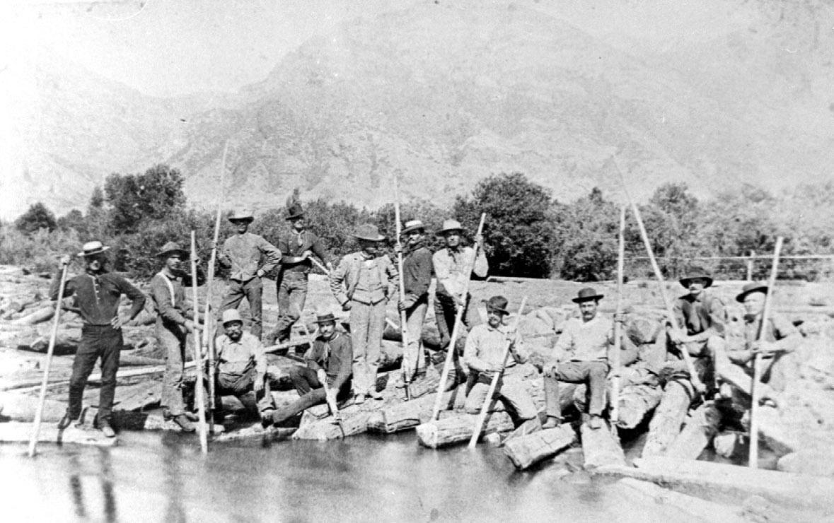
come in the afternoon,” indicating that the train was running from Wanship and carrying wood by that date.91 By the summer of that year, rail lines also stretched from Salt Lake City to Park City (the Salt Lake & Eastern) and from Ogden to Grand Junction (RGW).92 That spring of 1890, a “tie contractor for the extension of the Utah Central division of the Union Pacific” had posted notice seeking “500,000 ties” and “1,000 good tie makers.”93 Not surprisingly, by June 1890, the indomitable Judge Jones was “floating down some 90,000 railroad ties from the headwaters of the Provo River” for the UP and paying wages estimated at $40,000 for the season.94 A traveler’s report corroborated the Jones drive, noting that “quite a business in supplying mining timbers and logging is done by the people of Provo Valley. . . . Great quantities of lumber and railroad ties have been floated down the Provo this year, and many ties were piled in places along the stream, said to be for the extension of the Utah Central.”95 On the Weber River watershed, “the building boom” reportedly continued “with unabated vigor” during the summer.96 Several months later, in January 1891, the Kidder Brothers were still “shipping in a large supply of mining timbers for which they find a ready market.”97
Indeed, as the 1891 season began, tie-driving in the region looked promising. In May, news reports of J. L. Atkinson’s log drive on the Bear River down to Evanston appeared in the Salt Lake Tribune, while the Provo Evening Dispatch reported in June that “Mr. S. S. Jones . . . was successful yesterday in contracting with
120 UHQ I VOL. 90 I NO. 2
UHQ 90_2 Text.indd 120 4/8/22 1:36 PM
An 1888 railroad tie drive on the Provo River. Dan Jones, the manager of the project, stands in the center. Other identified members of the party include Josiah Smith (left) and Dan Vincent (extreme right). Utah State Historical Society, Larson Studio Collection, photograph no. 62.
the R.G.W. officials for 100,000 ties. These ties are to be used in the construction of the Provo-Tintic Short Line, and are to be gotten out at once. Mr. Jones says the contract will be the means of putting between four and five hundred thousand dollars in circulation this summer.”98 The Provo River was busy that summer. The Salt Lake Daily Tribune also reported that “the Utah Central—John M. Young’s road—has 100,000 railroad ties now in the Provo river, which were floated down from the headwaters of that stream. These ties are scattered along the river a distance of about twenty-five miles and will be taken out mostly at Davis’s and at Moon’s, two well-known crossing places on the river.”99 That same June the Park Record observed that the Kidder Brothers’ Park City mill received the last of their “Wanship wood this week. The lot comprised 13000 cords and has been arriving steadily for more than a year at the rate of from two to four cars per day.”100 Atkinson ran another log drive down the Bear River the following June, and a July 16, 1892, report from the Weber River from a traveler who journeyed all the way up to Holiday Park, noted that “about fifteen miles [up-river] from Peoa, is a saw mill and boom of saw logs, some 10,000 of them being bunched up there.” The traveler estimated that there was “fully a million feet at this one point, and at $25 per m, the snug sum of $25,000, or near that, will be taken in.”101 These “large quantities” of timbers were making their way to Park City mines by early fall, as the Park Record stated.102 In neighboring Idaho, a log drive of “nearly four million feet” concluded in September 1892 along the Payette River, although it was “unusually difficult and expensive this season.”103
By 1893, the nation was fully in the grip of economic depression, and the Panic of 1893 sent the Union Pacific Railroad into bankruptcy for the second time. It was only a temporary setback, however, as four years later the company had reemerged financially and continues to operate to the present day. Despite UP’s economic woes, proposals for new roads continued to receive favorable reception and promote the ability of the Weber and other river drainages to supply adequate timber, sustain the local economy and Park City’s mines, and create significant demands for timber.104 Indeed, as the Park Record, under the heading “Park Float,” duly
noted in late December: “considerable lumber is coming to town at the present time from the saw mills on the Weber river above Wanship. Most of it goes to the mines.”105 This would continue to be the case in 1894.106 In May 1895, S. S. Jones, who would soon become mayor of Provo (1889–1890), was “sending men to the head of the Provo river, Wasatch county, to cut timber. He expects to bring down logs enough to saw 100,000 feet of lumber” reported the Salt Lake Daily Tribune and as late as October, Jones was still advertising for “ties wanted.”107 Jones was evidently so enamored of the business that he even composed a poem, entitled “Adown the Provo River,” in which he mused, “Year after year the spring flood tide brings down thousands of railroad ties to make and mend the great highway of traffic through the State.”108
Yet Smoot’s earlier concerns about the destructive nature of the ties drives was also in evidence. In January 1890, for example, the Salt Lake Tribune reported that “the ties now being floated down Provo River have choked the flow on the northwest edge of town so that the water has overflowed the banks, and now covers much of the farmland in that vicinity. There is liable to be trouble unless the tie men clear a passage without delay.”109 And an August 1891 travelogue lamented that “the great drawback” to Wanship of late was that a Weber River tributary, “Silver Creek—once as clear and pure as could be found in the mountains” was being fouled “by the mills and concentrating works at Park City, which are situated on the headwaters of the stream.”110 Danger also lurked in May 1894, when the Daily Enquirer reported that “the large tie boom of S. S. Jones, at Provo bridge, threatens giving away. A number of ties did escape to the lake last evening. Mr. Jones has men constantly watching the timbers.”111 Similar concerns on the Ogden River quashed the dreams of one “Mr. Evans,” who sought to build an iron foundry and smelter that utilized the “thousands of acres of wood” at the river’s headwaters to produce his plant’s charcoal. His hopes of floating the wood down the Ogden River, however, conflicted with plans for a dam, and it was “this hitch in the affairs of Weber county that has driven Mr. Evans to Box Elder county.”112 Evans’s conundrum reveals how competing interests over commercial water uses were often resolved in favor of the
121 UHQ I VOL. 90 I NO. 2
UHQ 90_2 Text.indd 121 4/8/22 1:36 PM
greatest public good and—while tie driving was still a possible use of the region’s rivers—other uses had also emerged and were beginning to take precedence.
In addition to concerns about property destruction caused by the tie and log drives, the rate at which timbers were being cut and removed from the Weber, Provo, and other watersheds had also begun to cause alarm. In February 1895, for example, at the monthly meeting of the Utah Forestry Association, Dr. H. J. Faust proposed the creation of a state park encompassing “the headwaters of the four rivers known as the Provo, the Bear, the Weber and the Duchesne . . . so that the timber could be protected—which timber is fast being destroyed by timber men being employed from time to time in cutting ties and other timber.” The primary justification for such an action Faust argued, was “to protect the snows that fall so deep in the winter time and which afford us water for irrigation.” The worst offenders, Faust continued, were “the tie men [who] destroy more than any other class of lumber men.” While Faust understood that this would cause economic hardship to the “tie men,” he argued that “the most good to the greatest number of people should be observed.”113 The following month, the Utah Legislature memorialized its support for Faust’s proposal to protect the four watersheds “with a view to increasing the water supply for irrigation purposes.”114

Driving Beyond Statehood
On January 4, 1896, Utah became the forty-fifth state in the union. Among the many issues the new state had to grapple with was the reality of its aridity. Concerns about a water supply sufficient to slake the thirst of Utah’s growing population and its burgeoning agricultural economy were obviously at the heart of Faust’s proposal, but voices other than his had begun to join the chorus. In January 1896, Samuel Fortier, a professor at the Agricultural College of Utah (later Utah State University), wrote an extensive article for Salt Lake Tribune in which he detailed the rainfall totals in and agricultural potential of various parts of the state. Noting that the Weber River drainage covered 1,600 square miles, Fortier wrote with some concern that the previous year (1895) had marked the lowest flows since records had been kept; a similar situation existed on the Provo River. For Fortier, the irrigation development along the Bear River was the model to be emulated: “then it was a sagebrush desert . . . now is to be seen in autumn the rich dark green of lucerne fields.”115 While this vision of making the desert bloom echoed Brigham Young’s sentiments from a half-century earlier and was certainly not new, by the late nineteenth century, irrigated agriculture was increasingly becoming the primary economic driver of the region. These uses of the region’s rivers were not necessarily incompatible with tie and log drives that utilized waterways to transport timber to end users, but increasingly, irrigation interests took precedence.
Yet it was still the railroads that would transport this agricultural produce to eager consumers across the country, and those railroads still needed ties. In April 1896, the Salt Lake Tribune reported that “rapid progress is being made on the preparations for the Rio Grande Western’s extension to Park City,” later called the Heber Creeper. Moreover, “broad gauge railroad ties are in demand. The Salt Lake & Pacific is getting out a large number in the Weber canyon, but the supply is not equal to the demand and the company is looking around for another point of timber supply.” Not only was the Weber’s supply insufficient, but “the canyons near Provo have been productive of good timber for years, but the contractors have been recently deserting this region for other parts of the state.”116
122 UHQ I VOL. 90 I NO. 2
UHQ 90_2 Text.indd 122 4/8/22 1:36 PM
This mountain scene of fishing along a stream shows the effects of clear-cut logging. Church History Library, Charles W. Carter, C-286.
One man who worked the timber in the summer of 1896 was Seymour Bertie Allred, who was “cutting saw logs and mine props” on the Ham’s Fork, a tributary of the Blacks Fork and Green rivers. In his memoirs, Allred recalled that “the work consisted of chopping, trimming, and logging off, then snaking the logs to the bank of the stream where they were piled to await the high water in the Spring.” He noted that during that winter, “a timber crew” “hauled about eight thousand timbers down to the larger stream edge, preparatory to floating them.” The following April of 1897, Allred was “back on the job to help float the hundred and sixty-five thousand logs that I had helped to cut and bank the year before.” Allred provided a rare and fascinating glimpse into the mechanics of a big log drive, which he described as “twelve hours a day of wading, swimming, and sometimes, the carrying of logs from the leads where the back water had floated them.” He was pleased, however, to be “drawing top wages” of “three dollars a day,” which he received for manning the boat that took men out to the log jams. Allred’s other job was to sweep the
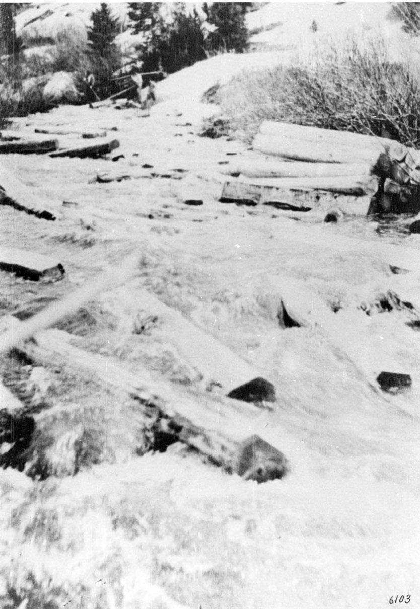
rear of the drive for stray logs: “this required much paddling across the stream, darting into small channels, watching all nooks and corners where a log might be pushed and become caught.” As the water warmed, “the men all became more daring,” and some of them rode logs in as they floated in the river, a feat Allred said “requires an experienced hand.”117
That same year, in 1897, Colonel N. W. Clayton, the manager of the Deep Creek Railroad who was planning to expand southwest out of Salt Lake City to the mining regions of western Utah and Nevada, expressed his confidence in the expansion of that road, eventually even to Los Angeles; and the Salt Lake Tribune reported that “there is plenty of available timber that can be cut into ties to be delivered on the line of the UP. Most of these localities are on the Park City branch of the UP, one contractor at Wasatch being ready to supply 75,000 ties in short order.” The article also noted that “ties have been floated down the Sevier,” “and thousands have been taken out of the Provo river.”118 To ensure that these ties were not poached from state lands, Utah had passed a law in 1896 stating that “the cutting and hauling of timber from leased agricultural or grazing lands to saw mills is prohibited.”119
By 1898, however, the Utah & Pacific had begun to bring in ties from Oregon to fill demand, while the RGW was still able to utilize “ties which were stacked up along the Provo river to near the headwaters six or seven years ago.”120 In 1899, the Oregon Short Line contracted with the Rock Springs Lumber Company for 250,000 ties to be floated down to Green River, Wyoming, “with the spring rise of the river.”121 The Rock Springs drive, hailed as “the biggest tie drive ever made in Wyoming,” also included “200,000 ties for the Union Pacific Railroad company, and 200,000 props for the Rock Springs coal mines.”122 The company also anticipated another drive of saw logs for the following year because low water in the river had thwarted its passage.123
By the turn of the twentieth century, much of the work being done on the Weber and other rivers along the Wasatch and Uinta ranges had shifted from primary use as a conduit of timber to that of providing irrigation and municipal water supplies.124 By 1903, for example,
123 UHQ I VOL. 90 I NO. 2
UHQ 90_2 Text.indd 123 4/8/22 1:36 PM
A Mill Creek log drive. Note the individuals working the drive in the top left portion of the image. Utah State Historical Society, C-331 fd. 3, no. 11.
the number of canals and ditches drawing water from the Weber River had ballooned from about a hundred at the time of statehood to more than 150.125 The railroad’s ability to haul in cheap timbers from Oregon also cut into the tie business in the region.126
This decline was evident in Albert Potter’s thorough 1902 survey of the state’s forests for the federal Bureau of Forestry. While his purpose was to assess the potential for various areas to be included in new national forest reserves, his detailed descriptions provide excellent insight into the state of the forests at the turn of the twentieth century. Potter’s account describes the Wasatch, Gunnison, and Sevier Forest Reserves and the impact of mining, sawmills, and stockyards on the forests, and provides a historical outline of specific sawmills in service and their vicinity to rivers and streams. In almost every canyon of the Weber and Provo rivers, Potter noted the remnants of the previous years’ tie and timber harvests: old sawmills, camps, and areas “cut out.”127 Top-grade timber was a rare commodity in many mountain valleys by the turn of the century, and sheep ranching had fully occupied the high country.128 Indeed, the evidence for the overuse of the mountain areas by various extractive enterprises is extensive and provides another explanation for the decline of tie driving on the Weber and other northern Utah rivers. In his examination of Utah’s environmental history, the historian Dan Flores writes that by 1881, “and continuing thereafter with mounting fury and frequency, the now deteriorated mountain watersheds began periodically to send tons of water, soil, and boulders rolling into the streets and irrigation works of the towns below them.” Despite the creation of eleven national forests by 1910, “grazing and logging pressure continued to be too intense on the Wasatch. By the 1920s a widespread land collapse had begun.”129
As a sampling of proximal rivers over the first decade of the twentieth century reveals, however, the use of tie and timber drives like those in Utah continued throughout the region despite the toll they were taking on the land.130 In 1901, the bar was raised higher yet when some 400,000 ties went down Wyoming’s Green River for the UP.131 Two years later, in 1903, the Payette River bore “over 3,000,000 feet” in the
Prestel log drive. “A force of thirty men is at work on the drive,” reported the Ogden Standard, “and everything possible is being done to hurry it along.”132 In June 1910, another Payette log drive was underway.133 And the March 19, 1911, edition of the Denver Post not only contained a rather striking photo of a drive of thousands of ties clogging the Medicine Bow River, “one of the water highways down which thousands of ties are driven every spring,” but also noted that this practice had been in place “since the early ‘90s” and that cutters were paid “14 cents Per Tie.” The article also provides helpful information about the economics of tieing at this time:
The minimum price now paid for standing timber for this purpose is $3.50 per thousand board feet. The average tree will give from three to four ties, and thirty ties are considered equivalent to 1,000 board feet of timber. In this manner the cost per tie to the contractor who sells to the railroad is approximately 11 to 12 cents. When the tie is delivered to the railroad, however, it costs the purchaser from 55 to 65 cents.134
Clearly, the contractor was still making the big bucks while the tie hack provided the labor.
In 1913, even after decades of natural resource exploitation, the Utah State Bureau of Immigration Labor and Statistics noted that the potential for tie and log drives remained in northern Utah, noting that there were “approximately three billion feet of timber” in the Uintas and stating that the Wasatch Range “contains considerable merchantable timber.” Furthermore, the report suggested that a stand of one hundred million feet of Englemann Spruce and Lodgepole Pine was at the ahead of the Provo River—and that those resources could readily make their way downstream for the sake of the Denver and Rio Grande Railroad: “In addition to saw timber, this tract will furnish a large amount of railroad ties and mining props for which there is always a good local demand. The river has already been driven on a small scale. A drive of fifty miles will land the logs at Heber City where there is an excellent site for a large saw mill.” Elsewhere, the report details
124 UHQ I VOL. 90 I NO. 2
UHQ 90_2 Text.indd 124 4/8/22 1:36 PM
the existence of an “extensive tract of timber” on the northern slopes of the Uintas and at the headwaters of the Blacks and Smiths forks of the Green River. The report notes the commercial value of the timber: how it constituted 150 million feet of material for sawing, ties, and mining props, and how it was “one of the best railroad tie-mining prop tracts in the State, since the material can be driven direct to the railroad.”135
Officials from the newly created national forests substantiated the perspective offered by the 1913 report. In a 1911 article, Daniel F. Seerey, “a lumberman attached to the local District Office of the Forest Service,” stated that the headwaters of the Provo River offered “one of the finest bodies of native timber which I have seen in the state . the logs can be driven down the Provo river to Heber at a very small outlay for river improvements.” Seerey went on to argue that hauling timber from Oregon, either for ties or mining timbers, made little sense: “thousands of dollars annually go out of the state for lumber purchased from Oregon. If there were a number of large mills locally, this money would be kept within the state.”136 The other development that supported these positive views of the continued profitability of timber harvest in the region was that Forest Service management of the timber resources also included reforestation programs that began, slowly, to replenish what had been cut out in earlier times. May of 1915, for example, saw “the planting of 100,000 trees on the north slope of Slate creek” near Kamas, and systematic timber surveys were in place by the 1920s.137 Thus, even in the early twentieth century, the rivers of the Wasatch and Uinta ranges were susceptible to tie drive usage, which was still considered a customary practice for transporting logs and timber from the mountains downstream to end users.
By April 1912, some enterprising businessmen had set out to re-realize this profit potential in the region and began floating “about 500,000 feet of saw timber” down Rock Creek, a tributary of the Duchesne River, to a new saw mill in Duchesne City. “Preparations are under way to bring timber down both the north and south forks of the Duchesne river and down the Strawberry.”138 Notably, by May 1914, the Park Record could report that “most of the timber” from the
upper portions of the Provo and Weber rivers, as well as from Beaver Creek, came down on sleds, rather than the river drives of years past. “Keefer and Thompson drove ties down Beaver creek to Wanship five or six times 25 or 30 years ago [1884–1889], and at about the same time S. S. Jones was driving the Provo to Provo City, and George Kidder the main Weber to Wanship.”139 The wording of the article suggests that while tie driving on the Weber was no longer the standard practice, it was still a possibility and one that was certainly in use on neighboring rivers. In July 1915, for example, the Timberman, a monthly magazine that discussed the timber industry, detailed the operations of the Standard Timber Company, which was organized in 1913. In 1915, the Standard cut and drove more than 1,000,000 feet of timber, most of it coming from Blacks Fork and Mill Creek, a branch of the Bear River. The company had a contract “to furnish practically all the ties” the UP would use in the Intermountain region and, accordingly, about half of the 1,000,000 feet would go for railroad ties; the rest would become mining timber. The Timberman clearly saw the forest as a harvestable resource, noting that the Standard “expects to finish cutting all the available timber in Mill Creek this year and then will turn its entire attention to Blacks Fork where there will be several years’ cutting. What was more, the Forest Service also benefitted from the cutting, as the Timberman noted: “The sale of this lumber nets the forest service $35,000 of which $13,000 will go to state schools and roads under the law appropriating 35 per cent of the proceeds of the sale of timber from the national forests to these purposes.”140
In fact, even as late as the 1920s, tie drives still occurred in the region’s rivers: in the spring of 1920, the Standard Timber Company prepared “to bring down 100,000 ties from the upper reaches of the [Blacks Fork] river” and, according to the local forest ranger, “is already planning for an energetic campaign of tie cutting, to begin immediately after the spring drive.”141
Not surprisingly, the next year the state engineer, Frank C. Emerson, documenting the drive’s destruction of irrigation works along the Blacks Fork, “was impressed by the magnitude of the damage and has taken the matter up with the Standard company.”142 Another report noted the Standard Timber Company’s use of
125 UHQ I VOL. 90 I NO. 2
UHQ 90_2 Text.indd 125 4/8/22 1:36 PM
the West Fork of the Smiths Fork (tributaries of the Blacks Fork and thus Green River) in Wyoming between 1927 and 1935 to “drive ties,” indicating that the practice was still an acceptable use of the river.143 Indeed, even as late as 1938, the Laramie River bore 350,000 ties down river, but after 1940, the UP refused to accept stream-driven ties.144
gh
The utilization of the Weber and other rivers in the region to support the commercial demand for tie and log drives was evident and significant between the 1850s and 1940, although the heaviest use certainly occurred during the development and expansion of the railroads and mines, the twin pillars of industry in Utah, between the late 1860s and the turn of the twentieth century.145 Interestingly, much of the perceived drop-off in lumbering may have come about as a result of the transition to federal forest control; the Forest Service kept better records and also began a more systematic effort to promote “conservation through utilization” and management of the resource “as a tie forest,” as evidenced by industry revival on the North Slope of the Uintas, for example. One other challenge and possible explanation for the decline of tie and log driving is that by the early twentieth century, while North Slope creeks could still float a tie or hewn lodgepole, they were simply inadequate for moving massive raw saw logs to the mills downstream, although there were proposals to “improve” the rivers to accommodate such drives.146
As this history demonstrates, the tie and log drives that occurred on the Weber River and other Utah and regional waterways throughout this period were an essential element of the larger railroad, mining, and timber economies of the West.147 Thousands of men like George Carter found work and wages as river hogs and tie hacks, which in turn accelerated the development and expansion of the interior West. As the historical archaeologist Christopher Merritt observes, “forgotten cabins, rotting back into the ground from which their logs once sprung, are the tangible reminders of this lost facet of western history.”148 In this arid environment, the region’s rare rivers provided highways of water upon which, for a time, an entire industry depended. The financial contributions of this other extractive endeavor, as well as the sheer volume of and extended time period over which these tie and log drives occurred, demonstrate its substance and significance to the settlement success of Utah as a territory and a state.
Notes
The author wishes to thank Cullen Battle, Herbert Ley, Vincent Fazzi, and three anonymous reviewers. Research of this kind would not be possible without the extraordinary resource provided by Utah Digital Newspapers (digital newspapers.org).
1. “Drowned,” Deseret News, July 25, 1877; Richard W. Sadler and Richard C. Roberts, The Weber River Basin: Grass Roots Democracy and Water Development (Logan: Utah State University Press, 1994), 99.
2. Henry Sompson (or Somsen) later laid a commemorative headstone to Carter on the left bank of the Upper Weber, a little below Smith and Morehouse Creek. See Brian Maffly, “Public Access on Weber River Hinges on Pioneer Log Drives,” Salt Lake Tribune, March 7, 2015, 4:57 p.m., September 13, 2020, archive.sltrib.com; Google Maps, accessed October 12, 2021, goo.gl/maps/WRbZokXgn6eKJUwX7. Ted Cannon, “Tragedy on Weber River,” Deseret News, July 27, 1965, repeated the spelling as “Sompson”; Olive Emily Somsen Sharp, Autobiography, MSS A 2038, Utah State Historical Society, Salt Lake City, Utah (hereafter USHS); Marie Ross Peterson, Echoes of Yesterday: Summit County Centennial History (Salt Lake City: Daughters of Utah Pioneers, 1947), 230; David Hampshire, Martha Sonntag Bradley, and Allen Roberts, A History of Summit County (Salt Lake City: Utah State Historical Society, 1998).
3. Ralph Clement Bryant, Logging: The Principles and General Methods of Operation in the United States (New York: John Wiley and Sons, 1913); Earl E. Brown, Commerce on Early American Waterways: The Transport of Goods by Arks, Rafts, and Log Drives (Jefferson, NC: McFarland, 2010); see also, Robert E. Pike, Tall Trees, Tough Men (New York: W. W. Norton,

126 UHQ I VOL. 90 I NO. 2
A stone near Oakley, Utah, memorializing George Carter that reads “Drowned in Tie Drive in Weber River Spring of 1877 Henry Sompson Foreman[.]”
UHQ 90_2 Text.indd 126 4/8/22 1:36 PM
Courtesy Cullen Battle.
1967) (New England); Malcolm Rosholt, The Wisconsin Logging Book: 1839–1939 (Amherst, WI: Palmer, 1980) (Midwest); William H. Wroten, “The Railroad Tie Industry in the Central Rocky Mountain Region: 1867–1900” (PhD diss., University of Colorado, 1956) (Rocky Mountains); Bill Loomis, “Shanty Boys, River Hogs and the Forests of Michigan,” Detroit News, April 11, 2012, accessed September 16, 2020, blogs .detroitnews.com/history/2012/04/11/shanty-boys -river-hogs-and-the-forests-of-michigan/.
4. Michael K. Young, David Haire, and Michael A. Bozek, “The Effect and Extent of Railroad Tie Drives in Streams of Southeastern Wyoming,” Western Journal of Applied Forestry 9, no. 4 (1994): 125; see also Robert G. Rosenberg, “Woodrock Tie Hack District, Bighorn National Forest Cultural Resource Management Plan” (Sheridan, WY: Bighorn National Forest, 1999), accessed May 9, 2019, wyoshpo.state.wy.us /pdf/TieHackCampsBighorns.pdf; Lyndia Carter, “Tie Drives Down the Provo River: Consolidated Sources List,” n.d., copy in author’s possession.
5. A notable exception to this oversight is Christopher W. Merritt, “Wooden Beds for Wooden Heads: Railroad Tie Cutting in the Uinta Mountains, 1867–1938,” Utah Historical Quarterly 84, no. 2 (2016): 102–117.
6. Bryant, Logging; Brown, Commerce on Early American Waterways; Wroten, “Railroad Tie.”
7. B. H. Roberts, A Comprehensive History of the Church of Jesus Christ of Latter-day Saints, 6 vols. (Salt Lake City: Deseret News Press, 1930), 3:269; Brigham H. Roberts, “History of the Mormon Church,” Americana, February 1912, 158–89; see also Sara Dant, “The ‘Lion of the Lord’ and the Land: Brigham Young’s Environmental Ethic,” in The Earth Will Appear as the Garden of Eden: Essays in Mormon Environmental History, ed. by Jedediah S. Rogers and Matthew C. Godfrey (Salt Lake City: University of Utah Press, 2019), 29–46; Leonard J. Arrington, Feramorz Y. Fox, and Dean L. May, Building the City of God: Community and Cooperation Among the Mormons (Salt Lake City: Deseret Book, 1976), 57. A brief version of the history of the uses of the Weber River appeared earlier as Sara Dant, “Going with the Flow: Navigating to Stream Access Consensus,” in Desert Water: The Future of Utah’s Water Resources (Salt Lake City: University of Utah Press, 2014), 144–59.
8. Territory of Utah Legislative Assembly, Acts, Resolutions, and Memorials Passed by the First Annual, and Special Sessions, of the Legislative Assembly of the Territory of Utah, Begun and Held at Great Salt Lake City, on the 22nd Day of September, A.D. 1851, also the Constitution of the United States, and the Act Organizing the Territory of Utah (Great Salt Lake City: Brigham H. Young, 1852), section 39; see also John Swenson Harvey, “A Historical Overview of the Evolutions of Institutions Dealing with Water Resource Use, and Water Resource Development in Utah, 1847 through 1947” (master’s thesis, Utah State University, 1989).
9. Wells A. Hutchings, Mutual Irrigation Companies in Utah (Logan: Utah Agricultural Experiment Station, 1927), 15.
10. Robert Gardner, Robert Gardner Journal, 1852 September, MS 6063, Church History Library, Church of Jesus Christ of Latter-day Saints, Salt Lake City, Utah (hereafter CHL). More specifically, according
to a 1902 US Bureau of Forestry survey, available timber during this period in the Wasatch and Uinta ranges’ watersheds included Engelmann spruce, blue spruce, Douglas fir, red fir (locally known as red pine), alpine fir, white fir, limber pine, lodgepole pine, ponderosa pine (locally known as bull pine), and cottonwood. See Albert F. Potter, Diary of Albert Potter, July 1902–November 22, 1902, Forest Service Intermountain Region, United States Department of Agriculture, Ogden, Utah (hereafter FSIR); also available as a transcription through Utah State University Forestry Extension, accessed October 21, 2021, forestry.usu.edu/files/potter-diaries.pdf. It should be noted that Potter’s historical tree identification does not always correspond with current taxonomy. For more comprehensive identification, see Michael Kuhns, A Guide to the Trees of Utah and the Intermountain West (Logan: Utah State University Press, 1998).
11. James E. Ayres, “Historic Logging Camps in the Uinta Mountains, Utah,” in Forgotten Places and Things: Archeological Perspectives on American History, ed. by Albert E. Ward (Albuquerque: Center for Anthropological Studies, 1983), 251; James E. Ayres, “Standard Timber Company Logging Camps on the Mill Creek Drainage, Uinta Mountains, Utah,” Proceedings of the Society for California Archeology vol. 9 (1996): 179–82; see also “Early Days in Ogden,” Deseret Weekly, February 23, 1895, for a discussion of early settlement.
12. While irrigation diverts significant quantities of these rivers’ waters today, historical stream flow data indicates that the Weber River’s flow regime was sufficient to sustain the tie and log drives from the 1850s to the 1890s. At the time of statehood in 1896, the Weber River’s maximum flow (mf) at the mouth of Weber Canyon was 7,980 cubic feet per second (cfs), and had averaged 5,590 cfs since 1890, when record keeping began. Significantly for log driving, the mean monthly flow in May (May mmf) was 3,172 cfs in 1896, and had averaged 3787 cfs since 1890. The Weber’s flows significantly exceeded the flows of other prominent log driving rivers in Utah. For example, the Provo River’s mf at the mouth of Provo Canyon in 1896 was 4150 cfs, and had averaged 2490 since 1890. Similarly, the Provo’s May mmf in 1896 was 1166 cfs, and had averaged 1384 cfs since 1890. Later records for the Upper Bear and Blacks Fork show that the two rivers had lower flows than either the Weber or the Provo. J.V.B. Wells, Compilation of Records of Surface Waters of the United States through September 1950, pt. 9 “Colorado River Basin,” p. 296, and pt. 10 “The Great Basin,” pp. 131–32, 173–74 (Washington: GPO, 1960). See also U.S. Geological Survey, National Water Information System, accessed October 21, 2021, help.waterdata.usgs.gov/.
13. “Map of the Weber River Drainage Basin,” in Jay D. Stannard, “Irrigation in the Weber Valley,” in Elwood Mead, Report of Irrigation Investigations in Utah (Washington, DC: GPO, 1903), 176, plate 12. See Union Pacific Railroad Company, Geography of the Union Pacific Railroad: Part 4—Utah, “Instruction Pamphlet; Unit Number A.5 (Union Pacific Railroad Company, 1910) for a general description of the Weber River; and “Weber and Its Tributaries,” Deseret Weekly, September 19, 1891, for a contemporary de-
127 UHQ I VOL. 90 I NO. 2
UHQ 90_2 Text.indd 127 4/8/22 1:36 PM
scriptive discussion of the area; S. McKenzie Skiles, Utah and SW Wyoming, 1896, 1cm=9 km (Salt Lake City: Utah Stream Access Coalition, 2013), copy in author’s possession. During the twentieth century, the United States Bureau of Reclamation began impounding the Weber River’s water as part of the Weber Basin Project; it built two dams along the Weber’s course, Echo Dam (1931) and Wanship Dam (1957), to facilitate irrigation along the burgeoning Wasatch Front. See for example Christopher J. McCune, “Weber River Project,” 2000, usbr.gov/projects/pdf.php ?id=210, and “Weber Basin Project,” 2001, usbr.gov/ projects/pdf.php?id=209, both at Bureau of Reclamation, accessed May 10, 2019.
14. E. G. Beckwith, “Explorations and Surveys for a Railroad Route from the Mississippi River to the Pacific Ocean: Report of Explorations for a Route for the Pacific Railroad, On the Line of the Forty-First Parallel of North Latitude” (Washington: A.O.P. Nicholson, 1854), 10–11.
15. “Biographies–Lorin Farr Part 16,” Winslow Farr Sr. Organization, 2, accessed September 13, 2012, winslowfarr.org, copy in possession of author and UHQ editors; Mark E. Stuart, “Uintah,” in Utah History Encyclopedia, uen.org/utah_history_encyclopedia/, and “A Brief History of the City,” uintahcity.com /history.htm, both accessed October 22, 2021; Forest Service Intermountain Region, US Department of Agriculture, Forest and Range Resources of Utah; Their Protection and Use (Washington, DC: US Department of Agriculture, 1930); Milton R. Hunter, ed., Beneath Ben Lomond’s Peak: A History of Weber County, 1824–1900 (Salt Lake City: Publishers Press, 1966), 169, chapter 12; see also Alfred Lambourne, Alfred Lambourne Writings, circa 1912, MS 4110, CHL; Charles S. Peterson and Linda E. Speth, A History of the Wasatch-Cache National Forest, September 25, 1980, submitted to the Wasatch-Cache National Forest, 111–21, accessed October 22, 2021, exhibits. lib.usu.edu/items/show/12565; Douglas M. Bird, “A History of Timber Resource Use in the Development of Cache Valley, Utah” (master’s thesis, Utah State University, 1964), 58–64, September 14, 2020, digitalcommons.usu.edu.
16. “Biographies–Lorin Farr Part 16,” 12.
17. “Biographies–Lorin Farr Part 16,” 12; see also F. Ross Peterson and Robert E. Parson, Ogden City, Its Governmental Legacy: A Sesquicentennial History (Ogden, UT: Chapelle, 2001), 31; Hunter, Beneath Ben Lomond’s Peak, chapter 13; Roberts and Sadler, The Weber River Basin, 125; Ralph B. Roberts, “Sawmills,” 1944, Special Collections and Archives, Merrill-Cazier Library, Utah State University, Logan, Utah (hereafter MCUSU); Peterson and Speth, Wasatch-Cache National Forest, 121.
18. Roberts and Sadler, The Weber River Basin, 125.
19. See for example Linda H. Smith, A History of Morgan County (Salt Lake City: Utah State Historical Society, 1999), 188; Elnora Arave Cox and Frederick James Wadsworth, “Biography of Abiah Wadsworth,” December 21, 1979, accessed May 16, 2013, leavesona tree.org/histories/Biography%20of%20Abiah%20 Wadsworth.pdf; Mrs. William Chadwick Stoddard, “History of Morgan County,” Morgan County (UT) News, May 2, 1947.
20. Wells, Compilation of Records of Surface Waters, pt. 9 “Colorado River Basin” and pt. 10 “The Great Basin.”
21. Peterson and Speth, Wasatch-Cache National Forest, 126.
22. Samuel B. Reed, “Report of Samuel B. Reed of Surveys and Exploration from Green River to Great Salt Lake City” (December 24, 1864), 2–5, 11, accessed October 22, 2021, library.centerofthewest.org/digital /collection/MS414/id/1550/; see also Thomas C. Durant, Report of Thomas C. Durant to the Board of Directors in Relation to the Surveys Made Up to the Close of the Year, 1864 (New York: William C. Bryant, 1866); Wroten, “Railroad Tie,” 5.
23. F. B. Hough, “Report on Kinds and Quantity of Timber Used for Railroad Ties,” in Nathaniel H. Egleston, Department of Agriculture Report on Forestry vol. 4 (Washington: Government Printing Office, 1884), 119–73.
24. Wroten, “Railroad Tie,” 26–28, 35–37, 93–156; see also Robert E. Gresswell, Bruce A. Barton, and Jeffrey L. Kershner, eds., Practical Approaches to Riparian Resource Management: An Educational Workshop (Billings, MT: US Bureau of Land Management, 1989), 189; Young, Haire, and Bozek, “The Effect and Extent of Railroad Tie Drives”; Joan T. Pinkerton, Knights of the Broadax: The Story of the Wyoming Tie Hack (Caldwell, ID: Caxton Printers, 1981).
25. Smith, A History of Morgan County, 259; see also Union Pacific Railroad Contract with Brigham Young, 1868, box 89, fd. 7, Brigham Young Office Files, CR 1234, CHL; Salt Lake Daily Telegraph, June 20, 1868; Thomas M. Stevens, “The Union Pacific Railroad and the Mormon Church, 1868–1871: An In-Depth Study of the Financial Aspects of Brigham Young’s Grading Contract and Its Ultimate Settlement” (master’s thesis, Brigham Young University, 1972).
26. Wroten, “Railroad Tie,” 3.
27. Brigham Young, 1868–1869, UPRR receipt for ties, reel 96; UPRR construction estimates, box 88, fd. 4; 1869–1870 financial reconciliation documents for railroad, box 89, fd. 19, all in CR 1234, CHL.
28. Brigham Young, UPRR final estimate, 1869, box 88, fd. 7, 13, CR 1234, CHL.
29. “200 Choppers and Hewers,” Deseret News, February 3, 1869; “Progress in Echo and Weber,” Deseret News, August 19, 1868; see also “Utah,” Daily Alta California, November 7, 1868; “Work on the Union Pacific Railroad,” Sacramento Daily Union, November 28, 1868.
30. Account Records of J. W. Davis and Associates, 1868–1870, 17, Levi O. Leonard Papers, MSC0159, Special Collections, University of Iowa Libraries, accessed May 9, 2019, digital.lib.uiowa.edu/cdm/compound object/collection/leonard/id/32716/rec/6.
31. Bird, “A History of Timber Resource Use,” 21–22. Lyndia Carter, “‘Tieing’ Utah Together: Railroad Tie Drives,” History Blazer (July 1996), accessed May 9, 2019, historytogo.utah.gov/railroad-tieing/.
32. Ayres, “Historic Logging Camps,” 251, and “Standard Timber Company Logging Camps”; see also L. J. Colton, “Early Day Timber Cutting Along the Upper Bear River,” Utah Historical Quarterly 35, no. 3 (1967); Wroten, “Railroad Tie,” 14; Greg Gordon, When Money Grew on Trees: A. B. Hammond and the Age of the Timber Baron (Norman: University of Oklahoma Press, 2014), 134–50.
33. Ayres, “Historic Logging Camps,” 252, and “Standard Timber Company Logging Camps.”
34. Colton, “Early Day Timber Cutting,” 203; see also Robert E. Strahorn, To the Rockies and Beyond . . .”
128 UHQ I VOL. 90 I NO. 2
UHQ 90_2 Text.indd 128 4/8/22 1:36 PM
(Omaha: New West Publishing, 1879), 85; and Peterson and Speth, Wasatch-Cache National Forest, 127, for details on the Hilliard flume. Wood was also used for charcoal; Stephen L. Carr, The Historical Guide to Utah Ghost Towns (Salt Lake City: Western Epics, 1972), 59–60; C. Gregory Crampton and Steven K. Madsen, “The Navigational History of Bear River: Wyoming, Idaho, Utah,” Elusive Documents, Paper 74 (1975), accessed April 9, 2021, digitalcommons.usu. edu/elusive_docs/74.
35. “Utah’s First Forest’s First 75 Years” (Washington, DC: United States Forest Service, 1972), 13. For the dangers, see Deseret News, June 24, 1868; “Drowned,” Salt Lake Daily Telegraph, June 20, 1868; James Henry Martineau, An Uncommon Common Pioneer: The Journals of James Henry Martineau, 1828–1918 (Provo: Brigham Young University, 2008), 149.
36. Wroten, “Railroad Tie,” 213–14, 218–20.
37. Colton, “Early Day Timber Cutting,” 203–204. The men rarely chose to cross the rivers by walking across the logs as this was considered far too dangerous, but jams sometimes left no other alternative. Wroten, “Railroad Tie,” 276; “Local and Other Matters,” Deseret Evening News, April 1, November 7, 1878, March 31, 1879; “Local Intelligence,” Chieftain (Evanston, WY), March 8, 1884; Robert E. Pike, “Hell and High Water,” American Heritage 18, no. 2 (February 1967).
38. Wroten, “Railroad Tie,” 11–15, 218; Sharp, Autobiography, 4; Young, Haire, and Bozek, “The Effect and Extent of Railroad Tie Drives,” 126; Peterson and Speth, Wasatch-Cache National Forest, 125–26.
39. Wroten, “Railroad Tie,” 75; see also Gresswell, Barton, and Kershner, Riparian Resource Management, 189; for a fictionalized version of tie hacking in the High Uintas, see Roy Lambert, High Uintas Hi! (Salt Lake City: Publishers Press, 1964).
40. Wroten, “Railroad Tie,” 270, 280. See also Compiled Laws of Utah 1888, Land Laws of the United States, Sec. 440: “All navigable rivers, within the Territory occupied by the public lands, shall remain and be deemed public highways. . . .” This is a US statute (R.S. 2476) applicable to the territories and reprinted in the Compiled Laws of Utah. While it is not a law passed by the territorial legislature, it could be used to support the existence of a public right to use all rivers in Utah meeting broad navigability for use standards, such as Colorado’s and others recognized in western states and territories at the time.
41. Smith, A History of Morgan County, 189.
42. Wroten, “Railroad Tie,” 248.
43. Smith, A History of Morgan County, 190, 260. For an extensive list of the early sawmills operating in Weber Canyon as far up-river as Holiday Park, see Peterson, Echoes of Yesterday, 242. See also “Uinta Mountains and Lumber,” Summit County, Utah, accessed May 9, 2019, summitcounty.org/212/Uinta-Mountains -Lumber.
44. Wroten, “Railroad Tie,” 20; Don Strack, Utahrails. net, accessed October 25, 2021, utahrails.net.
45. Deseret Evening News, October 26, 1869.
46. Wroten, “Railroad Tie,” abstract, 9n, 10, 17; see also Alta Byrne Fisher, “History of Moses Byrne,” The Cardon Families Organization, accessed May 13, 2019, cardonfamilies.org/Histories/MosesByrne.html; Gresswell, Barton, and Kershner, Riparian Resource Management; Peterson and Speth, Wasatch-Cache National Forest, 128, 123; see Young, Haire, and Bozek,
“The Effect and Extent of Railroad Tie Drives,” for list of dates for tie driving on Wyoming streams.
47. Wroten, “Railroad Tie,” 15, 22–24, 40n49; Peterson and Speth, Wasatch-Cache National Forest, 124; Sharp, Autobiography, 89; Bird, “A History of Timber Resource Use,” 33; Elizabeth Arnold Stone, Uintah County: Its Place in History (Laramie, WY: Laramie Printing Company, 1924).
48. Wroten, “Railroad Tie,” 41, 14n27, 45, 49, 50n73, 54, 55–56, 59, 137; see also Cache National Forest (Utah and Idaho), “History of the Cache National Forest / prepared by Supervisor’s Office, Dec. 1940,” USU Digital Exhibits, accessed September 14, 2020, exhibits.lib.usu.edu/items/show/12562; Brad Hansen, “Tie Drives in the Bear River Range” (unpublished paper, Utah State University, April 25, 2012), copy in author’s possession; Merlin R. Hovey, “Early History of Cache County,” 1936, MCUSU, accessed September 14, 2020, digital.lib.usu.edu/digital/collection /regreening/id/232; Thomas X. Smith, Account Book, 1879–1881, MS 11241, CHL.
49. Ayres, “Historic Logging Camps,” 252, and “Standard Timber Company Logging Camps.”
50. Strack, Utahrails.net; Edward L. Sloan, ed., Gazeteer of Utah and Salt Lake City (Salt Lake City: Salt Lake Herald, 1874); Letters to Brigham Young, October 15, 25, 1875, box 104, fd. 22, CR 1234, CHL; Strahorn, To the Rockies, 93–94; Salt Lake Weekly Tribune, May 6, 1880; H.L.A. Culmer, ed., Utah Directory and Gazetteer for 1879–1880 (Salt Lake City: H.L.A. Culmer, n.d); George E. Pitchard, A Utah Railroad Scrapbook (Salt Lake City: George E. Pitchard, 1987), accessed May 9, 2019, utahrails.net/pitchard/pitchard.php.
51. Charles S. Peterson, ed., “‘Book A—Levi Mathers Savage’: The Look of Utah in 1873,” Utah Historical Quarterly 41, no. 1 (1973).
52. Sharp mistakenly referred to construction of the Oregon Short Line, which was not organized until 1881. Sharp, Autobiography, 5; Territorial Enquirer (Provo, UT), May 24, 1879.
53. Deseret Evening News, July 16, 1877; see also Peterson, “‘Book A—Levi Mathers Savage’”; Marie H. Nelson, ed., Mountain Memories: A Book of Remembrance 1848–1986 (Kamas: Kamas Utah Stake of the Church of Jesus Christ of Latter-day Saints, 1986), 105. John Seymour, one of the men who worked the drives, wrote in his journal that “men would jump into the cold water early in the morning and be in and out of the water all day. They followed the logs down the river and would take them out at the boom at Wanship.” Another reminiscence fondly recalled “when the ‘tie men’ came down the [Weber] river in their red flannel shirts and big boots, dislodging the ties from the many jams which they made, sending them floating on down the turbulent stream.” Peterson, Echoes of Yesterday, 229–30. See also Charles T. Pluid, “Logging,” 7–8, Oral History interview by Debbie Pluid, box 2, fd. 27, David Crowder Collection, BYU-Idaho Library, Rexburg, Idaho; “The Railroad Tie Drive on Provo River, 1888,” photograph no. 62, batch 27, box 92, Larson Studio Negative Collection, MSS C 230, USHS; “Life Sketch of Seymour Bertie Allred,” M270.1 A4417a 197-?, CHL; Nephi Anderson, “When the Stove Smoked,” Improvement Era: Young Men’s Mutual Improvement Association 10, no. 7 (May 1907), 883.
54. Strahorn, To the Rockies, 122.
129 UHQ I VOL. 90 I NO. 2
UHQ 90_2 Text.indd 129 4/8/22 1:36 PM
55. Semi-Weekly Enquirer (Provo, UT), May 24, August 6, 1879; Logan (UT) Leader, “Local Lines,” October 30, 1879; Thomas X. Smith, Loose Leaf Receipts for Total Ties Received and Sent, 1879–1881, fd. 2, MS 11241, CHL; “Local and Other Matters,” Deseret Evening News, November 25, 1879.
56. Bird, “A History of Timber Resource Use,” 33.
57. Peterson, Echoes of Yesterday, 194–95.
58. Peterson, Echoes of Yesterday, 306; see also Lin Floyd, “Brief History of Oakley, Utah, and the William Stevens Family,” 2003, accessed May 9, 2019, famhistory1867.com/stevenshorton.html.
59. Carter, “‘Tieing’ Utah Together”; Forest Service Intermountain Region, Forest and Range Resources of Utah
60. “Railroad Ties Wanted,” Salt Lake Daily Herald, June 12, 1880; see also Salt Lake Weekly Tribune, October 9, 1880; Territorial Enquirer (Provo, UT), June 26, 1880.
61. “Park City Notes,” Salt Lake Weekly Tribune, October 2, 1880; see also Samuel Liddiard, Journal, 30, A1904, USHS.
62. Alva A. Tanner, A Castout Mormon (Oakley, ID: Selfpublished, 1919).
63. “The Railroads,” Salt Lake Weekly Tribune, January 1, 1881.
64. Liddiard, Journal, 30.
65. “Provo,” Salt Lake Herald, November 2, 1881; see also, Territorial Enquirer (Provo, UT), January 21, 1880, July 27, September 7, October 19, November 2, 1881.
66. Territorial Enquirer (Provo, UT), November 16, December 7, 1881; Salt Lake Herald, December 23, 1881.
67. “Wanted,” Deseret News, December 28, 1881; “Wanted,” Logan Leader, January 13, 1882; see also “Wanted,” Salt Lake Herald, December 9, 1882.
68. “Interesting to Tie Men,” and “100 Men Wanted to Chop and Bank Ties on the Provo River,” Territorial Enquirer (Provo, UT), July 27 (qtn.), September 10, 1881.
69. Salt Lake Herald, February 7, December 9, 1882; “Random References,” Ogden Standard, June 14, 1882; see also Territorial Enquirer (Provo, UT), October 19, 1881, for note that “wood cutters are called for and receive good wages” around Uintah.
70. Carter, “‘Tieing’ Utah Together.”
71. Sharp, Autobiography, 89–90; see also Logan (UT) Leader, “Big Tie Contract,” February 4, 1881, and “Our City and Its Surroundings,” August 1, 1882; Robert G. Rosenberg, “Woodrock Tie Hack District, Bighorn National Forest Cultural Resource Management Plan” (Sheridan, WY: Bighorn National Forest, 1999), accessed May 9, 2019, wyoshpo.state.wy.us/ pdf/TieHackCampsBighorns.pdf.
72. “Local Intelligence,” Chieftain (Evanston, WY), April 29, 1882; see also “Samuel Hamilton Dies,” (Evanston) Wyoming Times, August 29, 1918.
73. Carter, “‘Tieing’ Utah Together”; A. S. Condon, “A Big Wheel,” Ogden Herald, May 16, 1887. This assertion is corroborated by Forest Service Intermountain Region, Forest and Range Resources of Utah, 58; US Geological Survey, Reconnaissance Map: Salt Lake Quadrangle, Polyconic Projection (October 1885 repr. 1930).
74. “Islands of the Desert,” Salt Lake Tribune, September 8, 1887.
75. “Railroad Business,” Park (City, UT) Record, December 31, 1887 (qtn.), and “Railway Rumbles,” February 11, 1888; Lorenzo Stenhouse, Utah Gazetteer and Di-
rectory of Salt Lake, Ogden, Provo and Logan Cities, for 1888 (Salt Lake City: Lorenzo Stenhouse [?], 1888).
76. “Scarcity of Timber,” Deseret News, January 11, 1888.
77. “Territorial Topics,” Salt Lake Herald, May 22, 1888.
78. (Provo) Utah Enquirer, June 8 (qtn.), August 24, 1888.
79. (Provo) Utah Enquirer, July 13, 17, 20, 1888.
80. “Peoa Dots,” Deseret News, August 1, 1888; “Peoa Dots,” Wasatch Wave (Heber City, UT), May 4, 1889; see also Charles William Seymour, “Journal and Reminiscences,” ca. 1880–1906, MS 14977, CHL. Peterson, Echoes of Yesterday, 230, indicates that in some years, flows were not sufficient from Holiday Park, for example, to float “great piles” of cord wood; Sadler and Roberts, The Weber River Basin, 99, restates this same idea and likely used this as their uncited source.
81. “Provo Points,” Salt Lake Herald, June 17, 1888 (first qtn.); “Random References,” Standard (Ogden, UT), June 10, 1888 (second qtn.); “Tie Drives in Provo River,” Standard (Ogden, UT), May 20, 1888; “The Tie Drive,” Park (City, UT) Record, June 23, 1888; “Provo Points, Salt Lake Herald, June 23, 1888; “Floating Fragments,” Daily Enquirer (Provo, UT), June 26, 1888; “Provo Points,” Salt Lake Herald, July 22, 1888.
82. Wroten, “Railroad Tie,” 280.
83. Provo City Council, July 3, 1882, Journal of the Proceedings of Provo City Council from October 21, 1878–April 1, 1890, 143; “The Tie Drive Down the Provo River,” and “City Council,” (Provo) Utah Enquirer, June 1, 1888; Deseret News, June 13, 1888.
84. “Timber Suits,” Ogden Standard, July 10, 1886; “Timber Trespass Suits,” (Provo) Utah Enquirer, January 15, 1889; “A Heavy Suit,” Laramie (WY) Daily Sentinel, November 22, 1878, and “Personal, Local and General,” December 18, 1878.
85. “That Tie Drive,” (Provo) Utah Enquirer, June 8, 1888.
86. “An Act to Protect Irrigation Companies,” March 11, 1890, in Laws of the State of Utah, 1890–94 (Salt Lake City: Star Print, n.d.), 21.
87. (Provo) Utah Enquirer, June 7, 1889; see also “Provo Points,” Salt Lake Herald, June 5, 1889.
88. Salt Lake Herald, June 12, 1889.
89. (Provo) Utah Enquirer, August 9, 1889; see also Lyndia Carter, “Of Logs and Men,” [unpublished], copy in author’s possession.
90. Salt Lake Herald, August 30, 1889; see also, “Local Pickings,” Daily Enquirer (Provo, UT), August 30, 1889.
91. Mark Hopwood Bleazard, Diary: 1861–1921, 5, MS 2750, CHL, accessed May 9, 2019, catalog.lds.org/assets /d8f1ff67–2ba0–4705–9c02–9bba7fcc1a45/0/0; see also Salt Lake Tribune, January 9, 1890.
92. Park (City, UT) Record, April 5, 1890; Salt Lake Evening Times, April 8, 1890; Strack, Utahrails.net; “Desirable Changes,” Daily Enquirer (Provo, UT), March 19, 1889.
93. Daily Enquirer (Provo, UT), March 18, 1890.
94. Salt Lake Tribune, June 4 (qtn.), 9, 1890.
95. “Eastern Utah,” Deseret Evening News, July 22, 1890 (qtn.); Daily Enquirer (Provo, UT), August 11, 1890. Note this is likely a reference to the “old” Utah Central line, which had been merged into the OSL in 1889. An extension of that line was underway in 1890 from Milford, Utah, to Pioche, Nevada.
96. Park (City, UT) Record, July 19, 1890 (qtn.), January 24, 1891; see Wells, Compilation of Records of Surface
130 UHQ I VOL. 90 I NO. 2
UHQ 90_2 Text.indd 130 4/8/22 1:36 PM
Waters, pts 9 and 10; and Frederick Haynes Newell, Report of Progress of the Division of Hydrography for the Calendar Year 1895, US Geological Survey (Washington: Government Printing Office, 1896), 231–33, for historic stream flow measurements for both the Ogden and Weber rivers.
97. “Park Float,” Park (City, UT) Record, January 24, 1891; see also Robert Schmal and Thomas Wesche, “Historical Implications of the Railroad Crosstie Industry on Current Riparian and Stream Habitat Management in the Central Rocky Mountains,” in Gresswell, Barton, and Kershner, Riparian Resource Management
98. “News of our Neighbors,” Salt Lake Tribune, May 15, June 19, 1891; Dispatch (Provo, UT), June 3, 1891 (qtn.); see also Daily Enquirer (Provo, UT), May 16, June 27, 1891; Dispatch (Provo, UT), July 11, 1891; Carter, “‘Tieing’ Utah Together”; Steven Samuel Jones Papers, box 1, fds. 7, 11, MSS 1435, L. Tom Perry Special Collections, Harold B. Lee Library, Brigham Young University, Provo, Utah (hereafter HBLL).
99. “Rumbles of the Railroads,” Salt Lake Tribune, June 28, 1891; see also “Provo’s Peculator,” Salt Lake Herald, June 30, 1891.
100. “Park Float,” Park (City, UT) Record, June 20 (qtn.), July 11, 1891; see also Park (City, UT) Record, January 24, 1891, for Kidder ad.
101. “News of Our Neighbors,” Salt Lake Tribune, June 6, 1892, and “Up the Weber River,” July 16, 1892 (qtn.).
102. “Park Float,” Park (City, UT) Record, September 10, 1892.
103. “Progress at Payette,” Salt Lake Tribune, September 19, 1892.
104. “Utah Central Extension,” Salt Lake Tribune, December 28, 1892; see also “Bracing up the Central,” Salt Lake Daily Tribune, June 25, 1894.
105. “Park Float,” Park (City, UT) Record, December 23, 1893; see also Utah Gazetteer 1892–93 (Salt Lake City: Stenhouse, 1892); “Park City,” Salt Lake Tribune, January 1, 1896, for discussion of distribution of goods, including lumber, in Park City.
106. “Park Float, Park (City, UT) Record, October 27, 1894.
107. Salt Lake Tribune, May 22, 1895 (qtn.); “Ties, Ties, Ties,” Evening Dispatch (Provo, UT), October 9, 1895.
108. Box 2, fd. 4, Charles D. Fletcher Papers, MSS 1948, HBLL; see also Lyndia Carter, “Tie Drives Down the Provo River: Consolidated Sources List,” n.d., copy in author’s possession.
109. Salt Lake Tribune, January 9, 1890; see also Daily Enquirer (Provo, UT), January 8, 1890.
110. “Weber and Its Tributaries,” Deseret Weekly, September 19, 1891.
111. Daily Enquirer (Provo, UT), May 16, 1894.
112. “Now for Business,” Ogden Standard, November 10, 1894.
113. “Make a State Park,” Deseret Evening News, February 2, 1895; see also Deseret Weekly, January 12, 1895, 101. Faust had been exploring and laying claim to lakes along the Wasatch on behalf of Salt Lake City since at least 1890; see Daily Enquirer (Provo, UT), August 11, 1890.
114. “The Legislature,” Deseret Evening News, March 11, 1890.
115. “Irrigation,” Salt Lake Daily Tribune, January 1, 1896; see also Samuel Fortier, “Bulletin No. 38—Preliminary Report on Seepage Water and the Underflow of Riv-
ers” (1895), UAES Bulletins, Paper 7, accessed October 26, 2021, digitalcommons.usu.edu/uaes_bulletins/7/.
116. “Ties in Demand,” Salt Lake Daily Tribune, April 28, 1896; see also “Green River Resources,” Salt Lake Herald, January 21, 1897. The Salt Lake & Pacific was never built. Although he did not reveal the source of his timber, in May of 1896, “D. W. Gamble made an offer to furnish 200,000 ties” to the Utah & Pacific; “Branch to Park City,” Salt Lake Herald, May 30, 1896. See Map of Utah, 69.16=1 degree (Rand, McNally, 1895), for a map of railroads at statehood.
117. “Life Sketch of Seymour Bertie Allred,” CHL; see also “The Railroad Tie Drive on Provo River, 1888”; “Local Intelligence,” Chieftain (Evanston, WY), May 13, 1882.
118. “Deep Creek Railroad,” Salt Lake Tribune, February 3, 1897.
119. Laws of the State of Utah (Salt Lake City: Deseret News Publishing, 1896), 251; see also Thomas Donaldson, The Public Domain: Its History with Statistics . (Washington, DC: Government Printing Office, 1891).
120. “To Improve the Road,” Salt Lake Herald, November 14, 1898; see also “Bids for Track Work,” Deseret Evening News, September 17, 1898.
121. “To Improve the Roads,” Salt Lake Tribune, January 16, 1899.
122. “Northwest Notes,” Wasatch Wave (Heber City, UT), September 15, 1899.
123. “The Big Tie Drive,” Salt Lake Tribune, November 21, 1899; see US Geological Survey, Coalville Quadrangle, Polyconic Projection, 1927.
124. See R. L Polk, Utah State Gazetteer and Business Directory (Salt Lake City: R. L. Polk, 1900), for a discussion of Coalville, Oakley, and Wanship and the businesses in these towns, including lumber purveyors.
125. Fortier, “Bulletin No. 38”; Mead, Report of Irrigation Investigations in Utah; “Map of the Weber River Drainage Basin.”
126. “Great Body of Utah Timber,” Evening Standard (Ogden, UT), July 18, 1911.
127. Potter, Diary of Albert Potter.
128. Charles S. Peterson, “Albert F. Potter’s Wasatch Survey, 1902: A Beginning for Public Management of Natural Resources in Utah,” Utah Historical Quarterly 39, no. 3 (1971): 243–55.
129. Dan Flores, “Zion in Eden: Phases of the Environmental History of Utah,” Environmental Review 7, no. 4 (1983): 333–34; see also Young, Haire, and Bozek, “The Effect and Extent of Railroad Tie Drives,” for discussion of effect tie driving had on riparian zones and fish species in Wyoming.
130. Timber drives were occurring in neighboring Wyoming in 1898, where one sawmill received “a log drive of 1,000,000 feet of timber” and anticipated seven times that amount for the next year; see “Northwest Notes,” Wasatch Wave (Heber City, UT), May 6, 1898.
131. “Record Tie Drive,” Deseret News, August 7, 1901.
132. “Mountain and Coast,” Ogden Standard, September 11, 1903; see also Colton Clark, “Soaked Timber in Idaho’s Clearwater River,” Intermountain Histories, accessed September 16, 2020, intermountainhistories.org/items/show/104.
133. “Log Drive at Emmett,” Deseret News, June 4, 1910.
134. Denver Post, March 19, 1911.
131 UHQ I VOL. 90 I NO. 2
UHQ 90_2 Text.indd 131 4/8/22 1:36 PM
135. State of Utah: First Report of the State Bureau of Immigration Labor and Statistics for the Years 1911–1912 (Salt Lake City: Arrow Press, 1913), 58–60; see also Samuel Fortier, William M. Bostaph, A. F. Parker, The Davis and Weber Counties Canal Company: Engineer’s Reports (Ogden, UT: Davis and Weber Counties Canal Company, ca. 1911), 12. Fortier’s report is dated September 16, 1910.
136. “Great Body of Utah Timber,” Evening Standard (Ogden, UT), July 18, 1911.
137. “Budget of News Is Gathered by a Forester,” Ogden Standard, May 15, 1914; see also, Peterson and Speth, Wasatch-Cache National Forest, 136.
138. John R. Wilson, “River Logging Near Duchesne,” Vernal (UT) Express, April 26, 1912; see also, J. R. Wilson, “Duchesne City,” Vernal (UT) Express, August 23, 1912.
139. “Kamas,” Park (City, UT) Record, May 30, 1914.
140. “Salt Lake and Utah,” Timberman 16, no. 9 (July 1915), 49–50; see also “Personal Notes of Forest Interest,” Ogden Standard, May 24, 1916; F. S. Baker and A. G. Hauge, “Report on Tie Operation Standard Timber Co. Uinta National Forest, 1912–1913,” December 23, 1913, District Forest Ranger Office, Wasatch National Forest, Evanston, Wyoming.
141. “Great Log Drive to Bring 100,000 R.R. Ties Down,” Salt Lake Telegram, May 5, 1920; see also George Chandler Kidder, “State of Utah Death Certificate,” September 18, 1920, “Utah State Archives Indexes,” database, Utah State Archives, accessed May 9, 2019, archives.utah.gov/research/indexes.
142. Wyoming State Tribune, May 23, 1921.
143. T. H. Van Meter to Marvin Combs, March 11, 1965, memorandum, R4 History Collection R4–1680–2009–0398, FSIR. The USDA’s “Forest and Range Resources” report from 1930 states that even as late
as 1927 there were “81 active sawmills in the State,” yet “the annual cut of lumber fell from 25,709,000 feet board measure in 1880 to 7,623,000 feet in 1928.” It also notes that Utah timber harvest had fallen because “the products of northwestern operators now dominate the Utah market through the advantage of large-scale production,” and estimated that “practically 93 percent of the lumber (excluding props, poles, etc.) used in Utah is imported from other states.” See Forest Service Intermountain Region, Forest and Range Resources of Utah, 59–61. Historian Brad Hansen further notes that by the 1890s “most timbered areas of the Bear River Range were already logged out.” Brad Hansen, “Tie Drives in the Bear River Range” (unpublished paper, April 25, 2012), copy in author’s possession.
144. Young, Haire, and Bozek, “The Effect and Extent of Railroad Tie Drives,” 125; see also, John Kifner, “Last Log Drive in U.S. Floating to End in Maine,” New York Times, September 8, 1976; Robert S. Mikkelsen, “Growing Up Railroad: Remembering Echo City,” Utah Historical Quarterly 62, no. 4 (1994): 349–62, 355.
145. W. Dee Halverson, Logging along the Weber (Coalville, UT: Summit County Historical Society, 2011).
146. Peterson and Speth, Wasatch-Cache National Forest, 131–33, 140.
147. Baker and Hauge, “Report on Tie Operation”; Peterson and Speth, Wasatch-Cache National Forest, 134; see also John A. Vollertsen, “Tie Hackers on the Front Range, 1886–1887: Building the St. Paul, Minneapolis & Manitoba and the Montana Central Railroads,” Montana: The Magazine of Western History 67, no. 4 (2017): 39–56.
148. Merritt, “Wooden Beds for Wooden Heads,” 105.
132 UHQ I VOL. 90 I NO. 2
UHQ 90_2 Text.indd 132 4/8/22 1:36 PM


133 UHQ I VOL. 90 I NO. 2 For more info go to: indian.utah.gov/events/railroads-in-native-america
by the Utah Division of Indian Affairs, Utah’s Tribes and numerous organizational sponsors. UHQ 90_2 Text.indd 133 4/8/22 1:36 PM
Sponsored

134 UHQ I VOL. 90 I NO. 2
UHQ 90_2 Text.indd 134 4/8/22 1:36 PM
A map of the mining interests of William S. Godbe and his sons, showing especially the reach of their efforts throughout the Intermountain West. Courtesy William T. Parry.
The Mining Legacy of William S. Godbe
BY WILLIAM T. PARRY
William S. Godbe, a man who had a great cultural and religious impact on early Utah territory, embarked on a decades-long odyssey in mining in 1865, with little experience or training in mining. Godbe’s eight sons followed him into mining as they came of age. Together, they bought and sold numerous claims, organized more than twenty mining companies, and built and operated concentrators and smelters. The Godbes sought their fortunes in mining, made fortunes in profitable ventures, missed fortunes when they sold valuable claims, and lost fortunes as metal prices plummeted. The family’s mining activities and investments took place in Montana, Wyoming, Idaho, Utah, Nevada, and Arizona. Godbe’s contemporaries in mining activities included Matthew H. Walker, David F. Walker, Simon Bamberger, Samuel Newhouse, and Patrick Connor. In addition to Godbe’s role in the cultural tensions of the early territory, his mining activities and those of his sons also demonstrate that the family had an economic impact on the Great Basin. This takes on added significance when considering that one of Godbe’s most strident protests against Brigham Young related to the leader’s rejection of metal mining.
William Samuel Godbe arrived in Utah in 1851 at age eighteen as a convert to the Church of Jesus Christ of Latter-day Saints (LDS). He formed a lifelong partnership with another young convert, Benjamin Hampton. Godbe began work for a Latter-day Saint businessman, Thomas S. Williams, who sent him to northern California to act as his agent. This journey enabled Godbe to see the mining activity in California and possibly in Nevada. The young man opened his own sundry and drug store in 1854 and, by 1870, some estimates put his total assets at more than $300,000 (nearly $6 million in today’s dollars).
In 1868, Godbe and a handful of his close associates began criticizing Brigham Young and his policies in a publication they called the Utah Magazine, which eventually became the Salt Lake Tribune. Their group began a movement of reform for greater individual liberty, challenging Young’s infallibility and temporal power. Young envisioned Utah as a self-sufficient community centered on agriculture—this at a time when the approach of the transcontinental railroad portended the opening of
135 UHQ I VOL. 90 I NO. 2
UHQ 90_2 Text.indd 135 4/8/22 1:36 PM
Utah to outside markets. Accordingly, he attempted to suppress some forms of economic development in the territory, including the mining of precious metals. Godbe and his cohort disagreed. After publishing an October 1869 editorial in the Utah Magazine in which he urged development of Utah’s mineral resources, Godbe was expelled from the LDS church. His conflict with Young included the formation of a separate church known as the Church of Zion or the “Godbeites.” Godbe’s mercantile business began to decline at once following his excommunication.1 He was soon in debt by $100,000, with interest payments of $1,000 per month. As a consequence of his rising debt and falling income, he decided to enter the mining business. Recognizing his scant experience and lack of training, Godbe purchased a pair of mules and a wagon and traveled the mining region for two years.2
During the early decades of settlement in Utah, the LDS pioneers made a serious effort to determine the extent of mineral resources in the region. Men were sent to mine gold in California; lead near Las Vegas, Nevada, and Minersville, Utah; and lead and silver in Meadow Valley, Nevada, near Pioche. Prospecting the region and discovery of valuable ores began in earnest with the arrival of General Patrick Connor and his force of 750 volunteers from California and Nevada in 1862. Mining became a booming activity, despite the objections of Young.3 The first discovery was silver-bearing galena at Bingham in the Oquirrh Mountains west of Salt Lake City in 1863, and silver discoveries in the Wasatch Mountains east of Salt Lake City in 1864. Known mining districts increased from two in 1868 to forty-four at the close of 1871.4 By 1872, three thousand men were speculating in mines, five thousand were hunting for mines, and two thousand were working in mines.5 Within another year many hundreds of Latter-day Saint workmen were employed in mines or dependent on them.6
William S. Godbe was a polygamist, married to Ann Thompson, Mary Hampton, Rosina Colburn, and Charlotte Ives Cobb. Ann, Mary, and Rosina bore a large family that included eight sons: Samuel T., William C., and Alfred (Ann); Frank and Fred (Rosina); and Anthony, Ernest, and Murray (Mary). At least some of the brothers received educations that prepared them for
mining careers. At the age of eleven, Samuel and Frank were enrolled in the University of Deseret, which offered training in chemistry, geology, and mineralogy and employed a professor of analytical chemistry and metallurgy. Frank accompanied his father to England in 1873, where he entered Owens College, Manchester, until the end of 1874. Anthony and Ernest, at the tail end of the family, were educated in Utah institutions and also saw service as powder monkeys, delivering explosives to the miners before they were full-grown men. The two then developed into muckers, the lowest level of workman in a mine. Later they worked with the drill as miners and then were placed in positions of trust and responsibility.7
William S. Godbe’s first adventure in mining began when the news arrived in Salt Lake City in 1865 that a rich gold strike was discovered in the area of South Pass and the Sweetwater River, Wyoming. Gold was first discovered there in 1842; efforts to work the placers were followed by a great rush in 1869.8 Ore was generally crushed in a ten-stamp mill, and the gold was extracted on mercury amalgamating plates and a concentrating table. William S. Godbe and his partner Benjamin Hampton, the brother of his
136 UHQ I VOL. 90 I NO. 2
UHQ 90_2 Text.indd 136 4/8/22 1:36 PM
William S. Godbe. Utah State Historical Society, photograph no. 15188.
second wife, secured deeds or options on some mining claims in the area. Planning on mining lode gold rather than the placer gold then being extracted, Godbe went to San Francisco and purchased a five-stamp mill for crushing quartz ore and hauled it by wagon through Salt Lake City to Wyoming.9 All told the $25,000 investment produced no profit.10
Godbe was then attracted to the nearby Wasatch and Oquirrh mountains, where silver deposits were discovered. Despite the promise of rich ore deposits in the Wasatch Mountains, Godbe’s activities there met with disappointment. He was part owner of the Union Mining Company, which controlled a large number of valuable ledges in Little Cottonwood Canyon that were being opened in 1872.11 In the Galena Tunnel, owned by Judge G. W. Case and the Union Mining Company, workers found a vein fifteen-feet wide with a solid vein of high-grade silver ore four feet in width in 1874.12 The Belle also belonged to the Union Mining Company and had an inclined tunnel down 230 feet, with a vein two feet thick at the bottom in 1872.13 Following a few mining notices of expenditures, the Galena Tunnel was reported as abandoned, with a length unknown.14
The ore deposit that came to be known as the Carbonate Mine lies on the ridge between Mill D South Fork (Cardiff Fork) of Big Cottonwood Canyon and Mineral Fork. The first mining claim, the Homeward Bound Claim, was filed in October 1870 and set off a boom with subsequent claims such as the Provo, Little Giant, Sailor Jack, and many more.15 Little ore was obtained from these claims until, in 1875, a prospector discovered the primary ore body. The Carbonate Company of Salt Lake City then purchased the claims. Much silver and lead ore were extracted and the mine was the largest producer of lead in the Cottonwood Canyons area in 1878 and 1879. Godbe became interested in this mine during the period of greatest production from the Carbonate Mine.
Godbe filed an application for patent of the Daisy Mining Claim in 1877.16 The Daisy Claim was located in the area of overlapping claims adjacent to the Carbonate Mine. The following year, Godbe and others filed a complaint in Third District Court against Carbonate claim owners as defendants alleging that some areas
of the Provo Lode (later the Carbonate claim) claimed by Godbe and others had been taken by the defendants’ owners of the Carbonate Mine. The claim was for $150,000 damages and interest and an injunction to stop the defendants from taking any more ore from the premises.17 Soon after this suit was filed, the Carbonate Mine was sold to the Kessler Mining Company of New York City and no further news reports of the disposition of the suit were made.
Godbe then turned his attention to the Ophir District on the west side of the Oquirrh Mountains. Patrick Connor and his complement of California and Nevada volunteers prospected the Oquirrhs vigorously, beginning in 1865. Connor’s volunteers made the earliest find of rich silver ore in East Canyon (now called Ophir Canyon) in 1865. The discovery, located high on the ridge separating Ophir Canyon from Dry Canyon, was first named the St. Louis Lode but was renamed the Hidden Treasure in 1870. The Chicago claim was located in 1871 on the same fissure as the Hidden Treasure but about 200 feet lower down. The Hidden Treasure, Chicago, and nearby Sacramento, about 600 feet east of the Hidden Treasure, would become three of the most famous mines of the early days. Successful exploitation of these mines began after completion of the transcontinental railroad in 1869 and financial assistance of British investors.18
Twenty British companies were incorporated to operate in Utah mines between 1860 and 1873. Included were the Flagstaff and the Emma mines in Little Cottonwood Canyon incorporated in 1871.19 Godbe met with his first successful mining venture in Dry Canyon where the Chicago claim was located in 1871 and was shipping ore at the time. He applied for a patent on the Chicago and nearby Rambler mines in 1872.20 British investors organized the Chicago Silver Mining Company; they purchased the Chicago claim in 1873 with nominal capital of 150,000 pounds. With sale of his Chicago claim to the company, Godbe agreed to become general manager for two years at a salary equal to 2 percent of any dividend paid. The company paid a dividend of 31,380 British pounds from 1874 to 1876 (about $174,000).21 Outside capital played a major role in the development of the American West and, as the historian W. Turrentine Jackson noted, the territory relied on British investment during these years. Given his rebellion against Brigham
137 UHQ I VOL. 90 I NO. 2
UHQ 90_2 Text.indd 137 4/8/22 1:36 PM
Young’s push for economic self-sufficiency, Godbe’s sale of the Chicago claim to the British was certainly significant.22
The Chicago Silver Mining Company first shipped valuable silver ore to Liverpool, England, for smelting where its shares sold at a premium. Then a smelter was erected on the shore of nearby Rush Lake, along with steam hoisting works at the mine. In June 1875, the Chicago Silver Mining and Smelting Company purchased half interest in the Queen of the Hills and Flavilla claims for $350,000.23 By 1876, the Flavilla announced a quarterly profit of $80,000.24 Godbe shipped 1,300 carloads of silver-lead bullion to eastern refineries with a value of more than $3 million from his fifty-ton per day lead smelting furnace at Rush Lake.25 Ore taken from the Shamrock Mine in East Canyon (Ophir Canyon), owned in part by William S. Godbe, assayed as high as $27,000 per ton. Mine shipments were made that were valued at $1,800 to $5,600 per ton.26
Near the time of Godbe’s activities at Ophir, Samuel Hawks and James Ryan discovered the enormously rich Horn Silver deposit in the
San Francisco Mining District, about fourteen miles west of Milford, Utah. Godbe, who was not an owner of the Horn Silver Mine, first attempted to build a smelter to refine the Horn Silver ore in 1874, but the attempt failed. He then made a second attempt to smelt the ore that also failed. The Frisco Smelting Company was reorganized as the Frisco Mining and Smelting Company with principals William S. Godbe, Benjamin Hampton, and Frank Godbe (William’s eldest son) as secretary. William S., along with Hampton and Frank, built a third and successful smelter in 1877.27 Hampton also directed construction of five distinctive beehive charcoal kilns that remain as landmarks to this day. The charcoal was necessary fuel for the furnaces in the smelter, which consisted of a Number 5 Baker blower, two boilers, one engine, several pumps, a shaft furnace, and a reverberatory flue-dust slagging furnace.28 This custom smelter refined the Horn Silver ore from about 1877 to 1885, when mining was interrupted by a major cave-in in the mine. Aggressive mining of the large and rich silver ore body had caused the ground to settle for some time, and then on February 12, 1885, the mine

138 UHQ I VOL. 90 I NO. 2
UHQ 90_2 Text.indd 138 4/8/22 1:36 PM
Frisco Mining and Smelting Company smelter at Frisco, Utah, circa 1883. Rounded charcoal ovens can be seen on the right side of the image. Utah Historical Society, photograph no. 17566.
caved to the seventh level and closed the shaft. The mine eventually reopened, but the ore was processed at a smelter in Salt Lake Valley.29
The second Carbonate Mine near Carbonate Gulch about three miles northeast of the Horn Silver, discovered in 1878, was sold to Benjamin Hampton and Frank Godbe for $50,000, and the nearby Rattler claim was patented by Godbe in 1881.30 These two mines produced silver and lead ore that was refined at the Frisco Smelter. Total production was 2,593 tons of lead and 553,910 ounces of silver.31
William S. Godbe also acquired the Cave Mine in the Bradshaw Mining District, located about eight miles southeast of Milford. The mine on the west slope of Bradshaw Mountain near Cave Canyon was discovered in 1859 and claims were located in 1871. The ore was processed at the Frisco smelter. Samuel Godbe, at age twenty-six, became superintendent of the Cave Mine in 1884.32 William S. Godbe and Hampton sold the Rattler and Carbonate mines to M. P. Gilbert for $100,000 in 1901.33
In 1871, Godbe had his name on a stake in one of the veins of high-grade ore, as well as an interest in the celebrated Montana claim on Eureka Hill, just west of the town of Eureka, Utah, in the Tintic Mining District.34 The Tintic Mining District lies about sixty miles south of Salt Lake City. The first mineralization was discovered there in 1869, resulting in the location of the Sunbeam claim. The Eureka Hill deposit was located soon after in February 1870. Within days of the 1870 report, the Eureka Mining Company was organized with mines on Eureka Hill made up of 12,000 feet of rich assays under control of the new company.35 The Montana claim, formerly owned by Godbe, was a central claim in the Eureka Mining Company holdings. John Q. Packard, the principal stockholder, became wealthy from the proceeds of this and other mines.36
Following the mining activities at Frisco and surrounding areas, Godbe turned his attention to mining at Osceola, Delamar, and Pioche, Nevada. There, Godbe and his eight sons actively pursued mining activities in several districts and mines.
In 1880, Godbe attempted to develop gold placers at Osceola, Nevada. Osceola is the most
famous of the White Pine County, Nevada, gold districts. A gold-bearing quartz belt, found in 1872, was twelve-by-seven miles; there, placer gold was discovered in 1877. The deposit is forty-five miles from Ely, just west of Great Basin National Park, where some of the placer installations are still visible. The gold occurs in thick deposits of gravel on the west flank of the Central Snake Range. Godbe constructed thirty-eight miles of ditches and flumes, at a cost of $400,000. Placer development began in Dry Gulch, and between 1877 and 1880 three hundred to four hundred miners worked there.37 The important placers in Dry Canyon were the property of Osceola Gravel Mining Company, later known as Osceola Placer Mining Company.38 These companies were organized in 1885, with Godbe as vice president, and reorganized in 1891.39 Nuggets as large as twenty-four pounds were found in Dry Canyon, and the area produced 95,000 ounces of gold by 1900.40 Yet Godbe failed to make a profit on the venture. Placer mining in Dry Canyon ended in 1900 because of an inadequate water supply, and Godbe was defeated by Nevada’s arid climate.
The family also became involved in the Pioche, Nevada, mining area, which is located about 240 miles southwest of Salt Lake City at the northern base of the Ely Mountain Range and near the east flank of the Bristol Range. Most of Pioche is near the southeast end of the Bristol Range; the Ely Range is smaller, with a northwest to southeast trend. The first silver production from Pioche was valued at $20,000 from the Meadow Valley Company in 1869, and the Raymond and Ely in 1870. Production peaked at $5.5 million in 1872 with high grade silver ores. The ore from the Raymond and Ely and the Meadow Valley mines was transported south to Meadow Valley, where sufficient water was available for processing the ore. Additional smaller mining areas near the Ely District at Pioche included the Bristol and Jackrabbit districts, which were organized in 1876. But by 1876, the boom in Pioche had petered out and most adventurers in the area were moving on.41
William S. Godbe saw an opportunity in recovering additional silver from the mine waste. Extracting silver from the ores at this time required the Washoe process of pan amalgamation, which left 15 to 25 percent of the silver in
139 UHQ I VOL. 90 I NO. 2
UHQ 90_2 Text.indd 139 4/8/22 1:36 PM
the waste tailings.42 In 1879 to 1880, after the production peak had passed, Godbe purchased the tailings in Meadow Valley, now renamed Bullionville, with the intent of recovering the additional silver in the tailings. He and his eight sons played a role in Pioche from then onward. William S. Godbe erected a fifty-ton per day smelter and a 100-ton per day concentrator. The concentrator and smelter worked 40,000 tons of tailings and produced over $1,000,000 in silver-lead bullion.43 Bullionville became a lively community, where fifty men were employed.
William S. Godbe organized the Pioche Consolidated Mining and Smelting Company in 1885 in collaboration with New York investors. The company filed articles of incorporation in Salt Lake City in 1886 with William S. as president, Samuel Godbe as treasurer, and Anthony Godbe. It then acquired many of the Pioche-area mines, including the Raymond and Ely, Meadow Valley, Jackrabbit, and Yuba mines. The

Godbe family organized the Yuba Mining and Reduction Company and took over the American Flag, which produced steadily in 1888. The Godbe companies constructed two new smelters, constructed a railway that covered the sixteen miles to the Jackrabbit property, and improved mining shaft access to the Raymond and Ely workings.44
The price of silver had remained relatively constant for decades at about $1.30 per ounce until 1872, when William S. began his first successful mining operation at the Chicago Mine near Ophir, Utah. Successful mining enterprises throughout the American West were increasing the supply of silver; meanwhile, demand for the metal was determined by government purchases, such as in China and in British India for monetary use, industries, and arts. Then in 1873, Germany demonetized silver; France, Belgium, and Holland limited coinage of silver; and the Scandinavian countries abandoned the silver standard. The United States dropped the
140 UHQ I VOL. 90 I NO. 2
UHQ 90_2 Text.indd 140 4/8/22 1:36 PM
Pioche, Nevada, in the 1880s showing the waste dumps from the largest mines—the Raymond and Ely Mine (center right) and the Meadow Valley Mine (left)—looking south at Treasure Hill. Pioche appears in the foreground. Utah State Historical Society, photograph no. 19588.
silver dollar from its coinage system. India suspended free coinage of silver in 1893.
During the years of Godbe’s mining ventures, then, the price of silver steadily declined from near $1.30 per ounce during the Chicago Mine work at Ophir to $1.10 per ounce during Frisco and the beginning of the Bullionville operation. When the Pioche Mining and Smelting Company operations began in 1886, the price of silver stood at $1.00 per ounce; then, with a brief bounce in 1890, the price began a steep decline to $0.64.45 In 1892, work in one mine after another was suspended until only the Yuba was left operating. Then, even the Yuba closed when the miners quit because of low wages. At this stage, the global silver market defeated the Godbe expansion of mining ventures in Pioche. The Godbes returned to Bullionville and built a new reduction works at a cost of $175,000, but within three months, in early 1893, fire totally destroyed the facility.46

William S. Godbe, his sons, and his partners persisted in the Pioche area, with a portion of their efforts focused on chemical and other means for obtaining silver. For example, following experiments with various processes for extracting the silver from the Bullionville tailings, a trial run of Raymond and Ely and Mountain Meadow tailings by a cyanide process was reported “a grand success in 1892.” Godbe and his associates had at least a million dollars as a reward after he reconstructed the Bullionville mill using the cyanide process.47 Each of Godbe’s sons played a separate role in development of mining properties in the area. William C. Godbe had the shortest tenure at Pioche. He
managed the smelter company’s affairs at Bullionville for about four months in 1885. Then after traveling to Milford for a visit with family, he died from a self-inflicted gunshot wound at the age of twenty-three.48
Frederick Godbe began his work at Pioche in 1882 as a clerk in his father’s company offices in Bullionville and supervised concentration tables in the mill at Bullionville. Fred, along with Frank, purchased the Fred Mine at Hiko that displayed a promising ledge containing 400 ounces of silver per ton. Hiko is located seventy-four miles by road southwest of Pioche. Fred opened and tended the company’s store at Bullionville, made contracts for wood for fuel to roast the Bullionville tailings, and prepared carloads of concentrates for shipment to Bullionville.49 In 1884, Fred received orders to sell everything belonging to Bullionville Smelting Company and then resumed his position as clerk at the new smelter.50 Later, he took the place of an engineer who was injured at the smelter.51 Fred Godbe also helped put men to work on the Godbe’s iron mine at Stampede Gap in the southern Bristol Range about eight miles northwest of Pioche.52
In 1887 Samuel Godbe commenced work on the American Flag (Yuba) Mine owned by his father and Hampton and soon made a rich strike there.53 Within a year, Samuel became the superintendent of the Yuba Mine.54 Samuel and Ernest then began experimenting with the cyanide extraction process on ore from the Yuba Mine. Ernest was the inventor of an effective agitation-cyaniding process where the silver was extracted with a sodium cyanide solution.55
141 UHQ I VOL. 90 I NO. 2
UHQ 90_2 Text.indd 141 4/8/22 1:36 PM
A graph depicting the volatile price of silver (cents per ounce) from 1870 to 1920. Courtesy William T. Parry
The brothers continued exploring the Yuba, crushing the ore with a stamp mill, and concentrating the silver using the cyanide process.56 In 1898, a really fine body of high-grade ore was reported in the Yuba and the owners, using a cyanide extraction process, stood to make a fortune.57 The Yuba Mine produced ore valued at $178,000 from 1888 to 1914. For five years, Samuel also had charge of the Day Mine, and in 1919 the mine shipped thirty tons per day, containing twenty ounces of silver per ton.58
Ernest Godbe continued the mining legacy of his father. He was active in mining affairs in Pioche beginning with his report of the success of the Russell Process at Bullionville in 1887.59 Then in 1889 he partnered with his brothers in purchasing mining claims at Tramway and the Enamel claim. He advertised his services as an assayer at Bullionville in 1893.60 He became active in operating the Day Mine in 1898 (also known as the Jackrabbit) at the foot of the east slope of the Bristol Range about fifteen miles north of Pioche, and reported 100,000 tons of ore in sight containing forty to fifty ounces of silver per ton and 20 percent lead.61 He reported success with utilizing cyanide to extract silver at Bullionville in 1901, about the time of his patent on the process.62 He became the manager of the Meadow Valley, the Raymond and Ely, the Day mines, Mezappa, American Flag (Yuba), Hillside, Onondago, and others at Jack Rabbit, Zero claim, Deerfoot, Index, Williams, and Goodspeed from 1907 to 1910.63 The Yuba, Day, and Hillside mines were the only substantial producers during this time.
Frank Godbe began his activities in 1881 along with his father with the organization of the Bullionville Smelting Company. Frank was secretary of the company and general manager of the smelter.64 Bullionville Smelting Company soon had a small furnace operating and shipped fourteen car loads of bullion, which Frank valued at $30,000 while they were still experimenting with the mill process. He was appointed superintendent in 1887.65 In the spring of 1889, the Godbe payroll consisted of one hundred men and, in May, the group reached the 1,200-foot level of the Raymond and Ely Mine and found the pumps that had been abandoned in 1879. They began pumping and lowered the water level to the 1,400-foot level to look at the Black Ledge and found lead-zinc ore of little value.
The family had a record of experimenting with and speculating on processes and methods that sometimes yielded a profit and other times failed to do so.
In the early 1890s, William S. built a new smelter two miles north of Pioche and improved the Panaca shaft to the Raymond and Ely. Frank also took over the Jack Rabbit property.66 Frank became part owner of three claims in the Chief Mining District in 1905 as a stock holder in the Advance Gold Company. The Chief Mining District produced 189 tons of ore with a value of $7,306 long after formation of the Advance Gold Company.67
Alfred Godbe became well known with the Godbe mining activities in Pioche, beginning with testing and measuring tailings in Bullionville and proceeding with his sampling work at the furnace and the tailings in 1883 at the age of nineteen.68 He reported a big strike at the Raymond and Ely Mine in Pioche four years later.69 Alfred collaborated with his brother Ernest to purchase the Tramway Mine in the nearby Highland District in 1889, and then along with Frank and Samuel, he located the Enamel claim in the Ely District.70 In 1890 Alfred left his position as superintendent of the Pioche water works to concentrate on the Bullionville tailings.71 In 1891 he took charge of the Pioche Weekly Record, and in 1892 he opened an assay office in Pioche.72 Alfred later became an engineer for Pioche Consolidated Mining and Smelting Company, a position he held until his death in 1916. His son Ralph Godbe was assistant superintendent of the Chief Consolidated Mine in Eureka, Utah.73
Anthony Godbe’s activities reached Pioche in 1890 when he became active in overhauling the old Flag tailings at Bullionville for quicksilver (mercury).74 An enormous amount of quicksilver was wasted by the pan amalgamation or Washoe mill process and made its way to the tailings—and, just so, a small fortune could be secured by recovering the quicksilver from the tailings. In 1892, Anthony and his father acquired the Highland Queen and Tramway property in the Highland Mining District, neither of which reported production.75 Anthony later became general manager for the Ohio-Kentucky Mining Company of Pioche in 1908.76 Working for that company in 1906 and 1907, Anthony
142 UHQ I VOL. 90 I NO. 2
UHQ 90_2 Text.indd 142 4/8/22 1:36 PM
was successful with the development of the Susan Duster Mine, which had a huge deposit of silver-lead-ore zinc. He could report that the “Susan Duster ledge is a big one,” and that the Ohio-Kentucky shaft went down 200 feet.77
Murray Godbe began his experience at Pioche in 1886 at the young age of sixteen when he went there to take photographs.78 A few years later he found employment at the assay office of Pioche Consolidated Mining Company.79 He later became general manager of the Hamburg Mine located eight miles north west of Pioche. The mine was reported to have produced $110,000 by 1917.80
The Prince Mine became one of the most productive of all of the Godbe brothers mining ventures in the Pioche area. Anthony, Ernest, and Murray were the principals involved in the Prince. The first step in acquiring the Prince property was organization of the Phoenix Reduction Company, which Sam Newhouse, H. L. Hackett, Ernest, and Anthony owned. Ernest realized the Prince was one of the best and biggest properties in the district, and the Phoenix Reduction Company acquired the Prince mining claims in 1907.81 The Prince deposit was first located in the early 1860s and was formerly owned by Raymond and Ely.
Ernest Godbe became the manager of the Prince in 1907.82 The mine began to recover ore from above the water table, which was at about 500 feet down. The Prince Mine, under control of Anthony, Ernest, and Murray, produced ore containing nearly two million ounces of silver, 2.4 ounces per ton, from 746,000 tons of ore; the gross value of its lead, silver, and gold totaled $7,000,000 before 1920. Some exploration drilling located ore at about 850 feet deep, and deepening the mine, along with pumping the water, began under the management of Murray. When the mine reached the 850-foot level, an accident shut off the pumps and the mine was completely flooded by 1922. Work was suspended in 1923.83 The company was reorganized as the Prince Consolidated Mining Company with no Godbes in management positions, although they probably still owned stock in the company. By 1938, the Prince had produced only an additional 36,000 tons, valued at $872,728. The Godbes, then, participated in both periods of large output at Pioche. The first
period, peaking in 1872, produced the tailings at Bullionville and the second period, beginning in 1906, included the Prince. During the low-production period, which lasted from 1885 to 1905, Godbe properties produced eighty percent of the total district production.
Ever mindful of new mining investment opportunities, William S. and his son Samuel became aware of a gold discovery south of Pioche, on the west slope of what is now named the Delamar Range. John E. and Alvin Ferguson first discovered gold there in 1891, and the Magnolia claim was discovered by John E. Ferguson, Frank Wilson, and D. A. Reeves, who also located the April Fool Group of claims. The mining district was first called the Monkey Wrench or Ferguson District. Most claims near Magnolia were located in 1892.84 By 1894, the largest and richest mines were the Monitor, Jim Crow, April Fool, and Magnolia.85 Samuel Godbe acquired a $450,000 bond on the Jim Crow and Monitor claims in the district.86
In March to June of 1894, Samuel persuaded Joseph Raphael De Lamar of New York to invest. De Lamar, a sea captain turned capitalist, had speculated in several western mines; he bought the Monitor for $90,000 and Jim Crow for $66,000 and organized the Delamar, Nevada, Gold Mining Company. Some reports say the bond may have involved as much as $435,000, but other reports suggest only $150,000 was paid.87 De Lamar’s name was then applied to the mine, the community, the nearby valley, and the mountain range. The principal producing mines were the Delamar (also called the Monitor) and the April Fool on the slope above town. The Lucky Bar, Jim Crow, Monitor, and Monitor #2 claims eventually yielded $12,064,933. In 1902, Delamar properties were optioned to Jacob E. Bamberger and Simon Bamberger and the sale of the April Fool Mine at Delamar, Nevada, was consummated.88 The company’s articles of incorporation included William S. Godbe on the board of directors. The April Fool operated from 1892 to 1902 and produced a total of $876,811; of this amount, only $168,563 was produced after the sale of the April Fool Mine89
The April Fool changed hands again. Late in 1901, Simon Bamberger and William S. Godbe purchased the Delamar company holdings. The
143 UHQ I VOL. 90 I NO. 2
UHQ 90_2 Text.indd 143 4/8/22 1:36 PM
deal went through on the basis of $100,000 for the property, and the board was reorganized with Godbe as president and Bamberger as treasurer.90 With that, two men of significant consequence in Utah’s history—a future governor and the leader of a revolt against Brigham Young—became two of the principals in the Delmar company. Two of Godbe’s sons also continued with the company. Ernest was employed in 1902 as a metallurgist at Delamar applying the cyanide process to the newly discovered ores in the Magnolia, Hog Pen, and April Fool mines successfully, and Samuel became assistant general manager of Bamberger’s Delamar mines in 1903.91 A new mill was built and was in operation in 1903 after the death of William S. The Bamberger operation closed in 1909.92
In addition to these enterprises in Utah and Nevada, the Godbe men sought fortunes in mining throughout the American West. The
Keystone claim in the Goodsprings area of Nevada, which is on the west slope of the Spring Mountains near present-day Las Vegas, was first located in 1882. In 1892, rich gold ore in the Keystone attracted the attention of Samuel Godbe, who purchased an interest for $20,000. He netted $21,000 from two carloads of ore, and two more carloads brought in another $19,000.93 He sold a one-fourth interest in the Keystone for $50,000. The mine was in financial trouble in June 1895 and operated intermittently until 1897. The Keystone produced about $126,000 from 3,945 tons of gold ore during is history. Later, Samuel Godbe, then living in Los Angeles, installed a dry concentrating mill at the Otsego property in the McCracken District, near Kingman, Arizona.94 Separately, his father invested heavily in the Alice Mine located in the famous Butte Mining District, Montana.95 The Alice
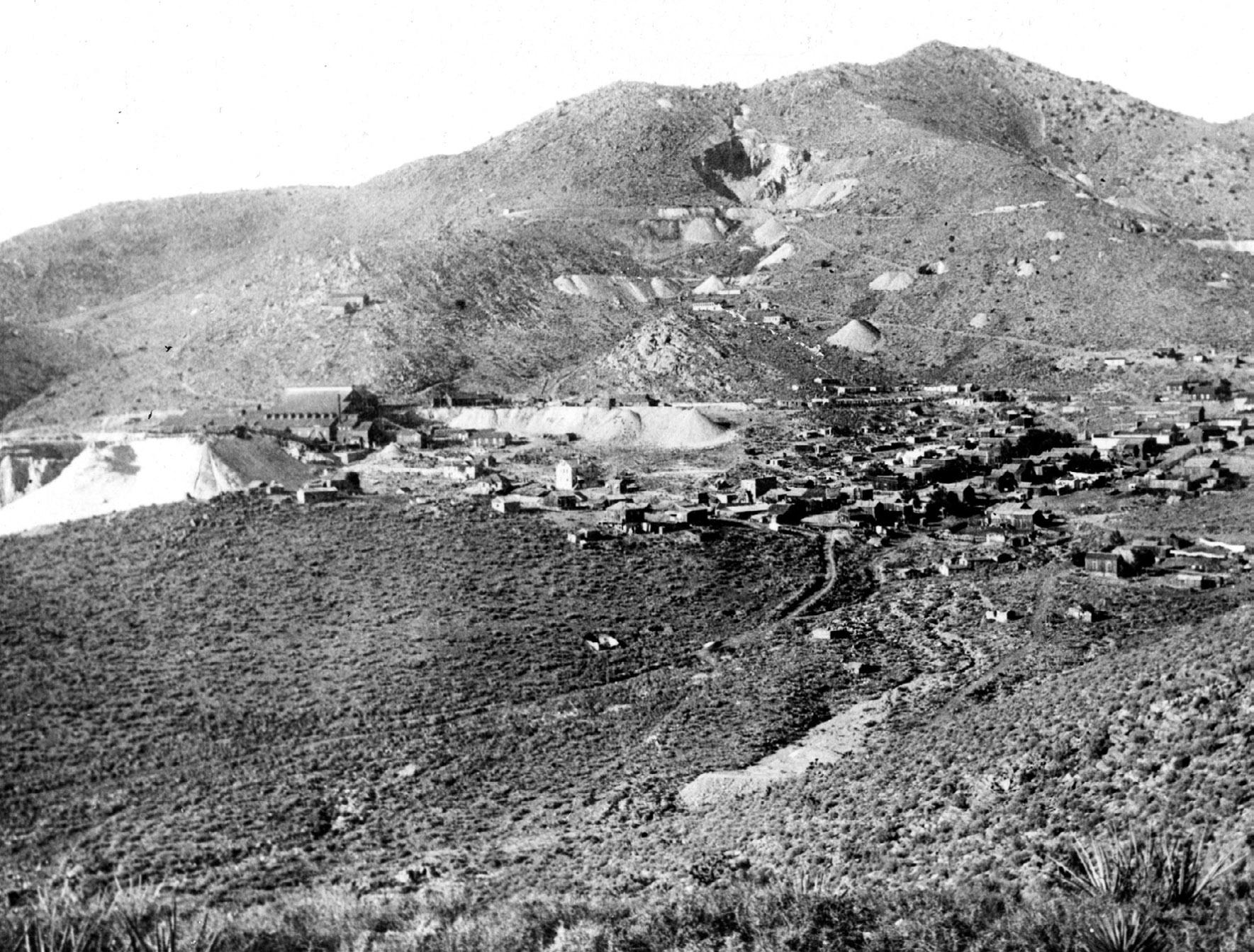
144 UHQ I VOL. 90 I NO. 2
Mine was owned by Matthew H. Walker and Joseph R. Walker, with offices
UHQ 90_2 Text.indd 144 4/8/22 1:36 PM
Delamar, Nevada, mines looking north from a hill south of town. The Delamar mill and tailings appear on the left, and the large open pit marking the Delamar Mine is above. The April Fool Mine is in the center right of the Delamar Mine, with the community of Delamar (Ferguson) in the foreground. Courtesy of University of Nevada, Las Vegas Special Collections and Lincoln County Museum.
based in Salt Lake City. The Alice represented the climax of the silver period in Butte.96
Then, in 1882, with his mining and refining activities in Pioche in full swing, William S. and his son Anthony began developing antimony deposits in the Coyote District, Utah. By February 27, 1883, a concentrator there was finished and the smelter was also ready for business.97
The Coyote District (renamed Antimony in 1921) is located on Coyote Creek, a branch of the East Fork of the Sevier River about forty miles southeast of Marysvale, Utah. The antimony deposits were located along Coyote Creek in 1879 and were worked intermittently beginning in about 1880. The American Antimony Company lasted only a few years because of a drop in the price of antimony and the high cost of transportation. Benjamin Hampton purchased the elder Godbe’s interest in the antimony mines of Coyote Canyon following his death in 1902.98 In 1905 two new companies, under lease of the Utah Antimony Mining Company, built a second mill.99 The Utah Antimony Company of Butte, Montana, filed articles of incorporation and planned to mine and refine antimony. Anthony Godbe and Ernest Godbe were among the incorporators.100 As was the case with many of the family’s ventures, the Coyote Mining District produced a relatively small amount of money—about $100,000 in antimony ore from 1880 to 1908.101
Samuel Godbe and Samuel Newhouse, representing an English-American syndicate, examined the Sevier Mine in the Gold Mountain District in 1895. The syndicate obtained an option for 250,000 shares in the summer of 1895.102 Godbe’s people paid $41,000 of the purchase price in 1896 when the option expired. Charles Lammersdorf, whose employees had discovered the mine, called the deal off and became the principal owner in 1897.103
The Sevier Mine is located in the Gold Mountain District, which was organized in 1889 and is located high in the Tushar Mountains a few miles northwest of Marysvale. Most of the production in the district came from the Annie Laurie and the Sevier mines. Ore was treated by unsuccessfully by amalgamation and also by cyanide. Production amounted to 143,228 ounces of gold and 460,228 ounces of silver, but there is no evidence that Godbe profited from the mines.104
The Godbes had their hands in several other efforts throughout Utah, both successfully and otherwise. The Shan Rheu Mining Company was organized in 1900, with Alfred Godbe as secretary, for the development of five mining claims in the Leamington District (Oak Creek).105 That district lies four miles southeast of Leamington, Utah, in the northwest flank of the Canyon Mountains, and the mines there produced very little silver ore. More fruitfully, Anthony and Ernest Godbe joined the officers of the Golden Rod Mining Company, which was incorporated in 1902 to work the Planetary Gold Mine in Park Valley.106 The Park Valley mining district in Box Elder County lies on the southern flank of the Raft River Mountains. Gold was discovered in Park Valley in about 1890, and by 1899 a small exploration boom involving the Century Mine developed.107 The nearby Planetary Mine was developed on a vein up to four feet wide, with a value of about $42 worth of gold per ton.108 Excellent ore reserves were blocked out in the Century Mine, and the employment of the cyanide process—as supervised by Ernest, its inventor—led to the recovery of gold.109
Ernest Godbe’s cyanide process showed promise elsewhere in Utah, as well. The Godbe process was used experimentally on tailings and slime from Mercur, Utah, at the Manning mill in 1901.110 Gold ore from the Mercur mines on the west flank of the Oquirrh Mountains was first treated by pan amalgamation in 1890, but the treatment failed to extract the gold. The Manning mill was subsequently remodeled and cyanide treatment succeeded.111 Cyanide is used extensively to this day in gold recovery.
Ernest and Anthony Godbe looked to Idaho as well, and acquired an interest in the Eddy Mine at Dixie in 1903.112 The Dixie Mining District was discovered in 1891, just about twenty miles northeast of Mountain Home, Idaho. The Eddy Mine is on a gold-bearing quartz vein about thirty inches wide, enclosed in granitic rocks. A five-stamp mill was installed in 1893 to process gold ore that contained enough gold to be worth more than $1,000 per ton, although not many tons were mined.113 Meanwhile, the two brothers reported the presence of rich ore at the Ella Hill Mine in 1903.114 The mine in the Neal District is fifteen miles east of Boise, Idaho, and was discovered in 1888. The main production came from the Homestake-Hidden
145 UHQ I VOL. 90 I NO. 2
UHQ 90_2 Text.indd 145 4/8/22 1:36 PM
Treasure, Golden Eagle, and Daisy mines. Ernest, as president, and Anthony, as secretary and treasurer, organized the Ella Hill Development Company.115 The Ella Hill Mine operated for a short time from 1902 to 1903. Total production from all of the mines in the district amounted to about 20,000 ounces of gold and 15,000 ounces of silver, but little of the production came from the Ella Hill.116
Murray Godbe continued his activities in mining development well into the 1920s. In 1909, he became a director of the Barney Canyon Mining Company located in the Oquirrh Mountains west of Salt Lake City.117 There is no record of gold production for this company, although in the 1990s, Kennecott mined about one-half million ounces of gold from Barneys Canyon. Murray launched Ophir-Mono Mines Incorporated, with backing from Detroit, Michigan, interests. Paul Billingsley, a noted mine geologist, was consultant. The properties making up the Ophir-Mono group were the Mono, Queen of the Hills, Garher, Brooklyn, and Wandering Jew.118 As manager of the Ophir-Mono Mines, in 1928, Murray acknowledged a strike involving 5.5 feet of ore with 28 to 47 ounces of silver and 23 percent lead.119 He was also the general manager of the Nevada Half Moon Mining Company.120
Hard work in the mines and exposure to toxic chemicals, including mercury and other metals, took their toll on the Godbes. William S. Godbe died at a cabin in Brighton, Utah, of nervous prostration in 1902 at the age of sixty-nine. William C. died in Milford, Utah, in 1885 by his own hand at the age of twenty-three. Ernest died in 1919 at fifty-two years old at Bass Lake, California, after a breakdown due to overwork. Frank died at the age of seventy-four of a lingering illness in 1932. Alfred died in 1916 in Pioche, Nevada, at the age of fifty-two of kidney and heart trouble. Frederick died of kidney disease in Salt Lake City in 1904 at the age of forty-two. Samuel Godbe resided in Los Angeles for thirty years prior to his death at age seventy-two in 1930 of a heart attack. Anthony died in a hospital in Provo in 1940 at the age of seventy-seven after a lingering illness. Murray died in 1930 at the age of fifty-nine of kidney and other diseases.121 Mercury is known to have toxic effects on the kidneys and on the nervous, digestive, and immune systems. Mercury vapors can also
cause behavioral disorders, emotional instability, neuromuscular changes, and headaches. Exposure to mercury and other metals likely contributed to the early deaths of the Godbes.
William S. Godbe, his eight sons, and his brother-in-law were active in many mines, erected and operated numerous smelters, and organized more than twenty mining companies. Yet they paid a tremendous price in health effects from overwork and exposure to toxic chemicals. The Godbes missed fortunes at Eureka, Utah, and Delamar, Nevada, when they sold their claims to others who made enormous profits. They lost fortunes when mines flooded and subsequent investments failed to produce profits. And they made fortunes when the recovery of silver from tailings and mining operations succeeded. With the exclusion of the Godbe brothers from management of the Prince Mine in 1923, the mining legacy of William S. Godbe began to fade after the 1920s, and the next generation carried on only a few mining activities. Most of the old mines are now closed and many of the western mining communities where the Godbes worked are now ghost towns.
Notes
1. Ronald W. Walker, Wayward Saints: The Godbeites and Brigham Young (Urbana: University of Illinois Press, 1998), 4, 5, 35, 36, 104.
2. William S. Godbe papers, 1884, ACCN 1507, Special Collections, J. Willard Marriott Library, University of Utah, Salt Lake City, Utah (hereafter JWML).
3. Leonard J. Arrington, “Abundance from the Earth: The Beginnings of Commercial Mining in Utah,” Utah Historical Quarterly 31, no. 3 (1963): 193.
4. John R. Murphy, The Mineral Resources of the Territory of Utah (San Francisco: A. L. Bancroft, 1872), iii.
5. Brigham D. Madsen, “General Patrick Edward Connor, Father of Utah Mining,” in From the Ground Up: The History of Mining in Utah, ed. by Colleen Whitley (Logan: Utah State University Press, 2006), 58.
6. Leonard J. Arrington, Great Basin Kingdom: An Economic History of the Latter-day Saints, 1830–1900 (Lincoln: University of Nebraska Press, 1958), 323.
7. “Biography of Leading Mining Men,” Salt Lake Mining Review, June 6, 1909, 4.
8. Albert B. Bartlett and J. J. Runner, Atlantic City, South Pass Gold Mining District, State of Wyoming Geologist’s Office, Bulletin No. 20 (July 15, 1926), 3–23. Placers are gold flakes and nuggets incorporated into unconsolidated sediment, such as river sand. Lode gold occurs within a solid tabular vein.
9. In nineteenth-century silver mining in Utah and Nevada, the processing of mined silver ore involved first crushing the ore and then extracting the silver. The crushing was accomplished with what was known as a stamp mill: a steam engine drove a quickly rotat-
146 UHQ I VOL. 90 I NO. 2
UHQ 90_2 Text.indd 146 4/8/22 1:36 PM
ing cam shaft that would raise and drop heavy iron stamps.
10. Walker, Wayward Saints, 41.
11. Rossiter W. Raymond, Statistics of Mines and Mining in the States and Territories West of the Rocky Mountains (Washington, DC: Government Printing Office, 1872), 219.
12. “Galena Tunnel,” Salt Lake Tribune, September 23, 1874, 4.
13. “Little Cottonwood Mining Summary,” Salt Lake Herald-Republican, November 3, 1872, 2.
14. D. B. Huntley, “Early Mining History of Utah,” in US Census Bureau, Tenth Census of the Population, 1880, vol. 13, 422. Despite newspaper reports of the thickness and richness of the vein, no known published production from the Galena tunnel or the Belle exists.
15. Charles L. Keller, The Lady in the Ore Bucket: A History of Settlement and Industry in the Tri-Canyon Area of the Wasatch Mountains (Salt Lake City: University of Utah Press, 2001), 211–14; F. C. Calkins, B. S. Butler, and V. C. Heikes, Geology and Ore Deposits of the Cottonwood-American Fork Area, Utah, US Geological Survey Professional Paper 201 (Washington, DC: Government Printing Office, 1943), 104–106.
16. “Daisy Mining Claim,” Salt Lake Tribune, October 26, 1877, 3.
17. “Another Big Mining Suit,” Salt Lake Tribune, February 22, 1878, 4; “The Carbonate,” Salt Lake HeraldRepublican, February 22, 1878, 3.
18. James Gilluly, Geology and Ore Deposits of the Stockton and Fairfield Quadrangles, Utah, US Geological Survey Professional Paper 173 (Washington, DC: Government Printing Office, 1932), 120, 121, 137; Arrington, “Abundance from the Earth,” 203, 205.
19. Clark C. Spence, “British Investments and the American Mining Frontier, 1860–1901” (PhD diss., University of Minnesota, 1958), 9, 599; W. T. Jackson, “British Impact on Utah Mining Industry,” Utah Historical Quarterly 31, no. 4 (1963): 349, 352, 361.
20. Walker, Wayward Saints, 375; Sketches of the Intermountain States: Together with Biographies of Many Prominent and Progressive Citizens Who Have Helped in the Development and History—Making of This Marvelous Region, 1847–1909, Utah, Idaho, Nevada (Salt Lake City: Salt Lake Tribune, 1909), 375; Gilluly, Geology and Ore Deposits, 120–22; B. S. Butler, G. F. Loughlin, V. C. Heikes, and others, The Ore Deposits of Utah, US Geological Survey Professional Paper 111 (Washington, DC: Government Printing Office, 1920), 378.
21. Spence, “British Investments,” 9, 599; Jackson, “British Impact,” 361; “The Chicago and Rambler Mines,” Salt Lake Herald-Republican, June 19, 1872, 2.
22. W. T. Jackson, “British Impact on Utah Mining Industry.”
23. “Dry Canyon Mines,” Salt Lake Tribune, June 29, 1875, 4.
24. “Profitable Silver Mines,” Salt Lake Herald-Republican, July 2, 1876, 3.
25. Sketches of the Intermountain States, 369.
26. Gilluly, Geology and Ore Deposits, 120–22; Raymond, Statistics of Mines and Mining, 219.
27. William B. Wray, “Mines and Geology of the San Francisco District, Utah,” in Mining Districts of Utah, ed. by Roger L. Bon, Robert W. Gloyn, and Gerald M. Parks, Utah Geological Association Publication 32 (2006), 304, 313.
28. Philip F. Notarianni, “The Frisco Charcoal Kilns,” Utah Historical Quarterly 50, no. 1 (Winter 1982): 40–46; Douglas H. Page Jr., Sarah E. Page, Thomas J. Straka, and Nathan D. Thomas, “Charcoal and Its Role in Utah Mining History,” Utah Historical Quarterly 83, no. 1 (Winter 2015): 20–37.
29. B. S. Butler, Geology and Ore Deposits of the San Francisco and Adjacent Districts, Utah, US Geological Survey Professional Paper 80 (Washington, DC: Government Printing Office, 1913), 114.
30. Wray, “Mines and Geology of the San Francisco District, Utah,” 304.
31. Butler, San Francisco and Adjacent Districts, Utah, 178.
32. “Nearly Suffocated,” Deseret News, August 27, 1884, 12; Butler, San Francisco and Adjacent Districts, Utah, 113, 530–31.
33. “Rattler and Carbonate,” Salt Lake Tribune, May 12, 1901, 6.
34. “Mineral Department,” Salt Lake Tribune, April 28, 1871, 2.
35. “New Mining Company,” Salt Lake Herald-Republican, April 30, 1871, 3.
36. “Organization of the Eureka,” Salt Lake Herald Republican, May 31, 1871, 3.
37. F. B. Weeks, “Geology and Mineral Resources of the Osceola Mining District, White Pine County, Nevada,” in Contributions to Economic Geology, 1907, Part I, by C. W. Hayes and Waldemar Lindgren, US Geological Survey Bulletin 340-A (Washington, DC: Government Printing Office, 1908), 117–33.
38. “Osceola Placer,” Salt Lake Tribune, January 1, 1885, 6.
39. “Note and Personal,” Salt Lake Times, April 28, 1891, 6; Maureen G. Johnson, Placer Gold Deposits of Nevada, US Geological Survey Bulletin 1356 (Washington, DC: Government Printing Office, 1973), 93–95.
40. Bertrand F. Couch and J. A. Carpenter, “Nevada’s Metal and Mineral Production (1859–1940),” University of Nevada Bulletin 38, no. 4, Nevada State Bureau of Mines, 1943.
41. Lewis G. Westgate and Adolph Knopf, Geology and Ore Deposits of the Pioche District, Nevada, US Geological Survey Professional Paper 171 (Washington, DC: Government Printing Office, 1932), 5, 6; Aaron J. Ardley, “Early Pioche: Conflict and Convergence on the Mining Frontier,” Intermountain Histories, accessed October 6, 2021, intermountainhistories.org /items/show/370.
42. Gregory Crouch, The Bonanza King: John Mackay and the Battle Over the Greatest Riches in the American West (New York: Scribner, 2018), 108–109.
43. Sketches of the Intermountain States, 375; Hulse, Lincoln County, Nevada, 41, 43.
44. “The Pioche Consolidated,” Salt Lake Tribune, June 25, 1886, 4; Hulse, Lincoln County, Nevada, 41; Sketches of the Intermountain States, 375.
45. Herbert M. Bratter, The Silver Market, US Department of Commerce Trade Promotion Series no. 38 (Washington, DC: Government Printing Office, 1932), 7, 30, 31, 80.
46. “The Bullionville Loss,” Salt Lake Herald-Republican, July 4, 1893, 8; Hulse, Lincoln County, Nevada, 47.
47. “The Trial Run a Success,” Salt Lake Times, October 10, 1892, 4; “From the Ferguson District,” Salt Lake Herald-Republican, January 18, 1895, 3; Hulse, Lincoln County, Nevada, 41, 47; Sketches of the Intermountain States, 375.
147 UHQ I VOL. 90 I NO. 2
UHQ 90_2 Text.indd 147 4/8/22 1:36 PM
48. “Suicide of W. C. Godbe,” Salt Lake Herald-Republican, February 8, 1885, 12; “Suicide at Milford,” Deseret News, February 11, 1885, 9.
49. “Bullionville and Panaca Dots,” Pioche (NV) Weekly Record, April 8, December 16, 1882, February 2, March 1, 1884, 3; “Bristol Items,” Pioche (NV) Weekly Record, June 14, 1884, 3; John M. Townley, “The Delamar Boom,” Nevada Historical Quarterly 15, no. 1, (1972): 3–20.
50. “Bullionville and Panaca Dots,” Pioche (NV) Weekly Record, March 22, September 27, 1884, 3.
51. “Local Intelligence,” Pioche (NV) Weekly Record, June 23, 1892, 3.
52. “Bullionville and Panaca Dots,” Pioche (NV) Weekly Record, September 23, 1882, 3.
53. “Pioche, Nevada,” Salt Lake Democrat, April 22, 1887, 5; “The American Flag,” Salt Lake Herald-Republican, September 8,1887, 8; “A New Mining Corporation,” Salt Lake Herald-Republican, April 18, 1888, 8.
54. “Local Intelligence,” Pioche Weekly Record, June 8, 1889, 3.
55. Ernest L. Godbe, Patent 682,612, 1901; see also, R. Robine and M. Lenglen, trans. J. Arthur LeClerc, The Cyanide Industry Theoretically and Practically Considered (New York: John Wiley, 1906), 381; “The Yuba Mine,” Salt Lake Tribune, January 2, 1898, 6.
56. “Mines of the South,” Salt Lake Tribune, February 21, 1898, 6.
57. “Mining Notes and Personals,” Salt Lake HeraldRepublican, June 19, 1898, 3.
58. “Black Metals and Ore Sales,” Salt Lake HeraldRepublican , June 29, 1919, 37.
59. The Russell process emphasized the use of copper sulfate and sodium thiosulfate (Na2S2O3) solution for extraction of the silver, which was then precipitated with sodium sulfide. This process was used with some impressive results in Pioche as reported by Ernest Godbe, “The Russell Process,” Salt Lake Democrat, July 12, 1887, 4.
60. Pioche (NV) Weekly Record, July 20, 1893, 3.
61. “In Jackrabbit District,” Salt Lake Herald-Republican, October 23, 1898, 6.
62. “With Engineers and Millmen,” Salt Lake Mining Review, March 30, 1901, 10.
63. “Ohio-Kentucky Not in Consolidation Deal,” Salt Lake Herald-Republican, January 16, 1908, 6; “Have Two Big Mines,” Pioche (NV) Weekly Record, November 30, 1907, 1; “Organization Complete,” Salt Lake Tribune, February 22, 1905, 6; “Nevada-Utah Activity,” Salt Lake Telegram, April 26, 1906, 8; “New Owners for Nevada-Utah Co.,” Salt Lake Tribune, October 19, 1910, 8; “Titles to Pioche Bonanzas Filed,” Salt Lake Herald-Republican, May 26, 1907, 27; “Nevada-Utah Preparing to Produce the Millions of Ore in Sight,” Salt Lake Herald-Republican, February 14, 1906, 6.
64. “Local Intelligence,” Pioche (NV) Weekly Record, April 30, 1881, 3; “Bullionville and Panaca Dots,” Pioche (NV) Weekly Record, August 5, 1882, 3.
65. “Local Intelligence,” Pioche Weekly Record, May 7, 1881, March 19, 1887, 3.
66. Hulse, Lincoln County, Nevada, 47.
67. “New Mining Companies,” Salt Lake Telegram, July 19, 1905, 6.
68. “Bullionville and Panaca Dots,” Pioche (NV) Weekly Record, August 18, 28, 1883, 3.
69. “Personal,” Salt Lake Herald-Republican, February 6, 1887, 9.
70. “Local Intelligence,” Pioche (NV) Weekly Record, March 23, 1889, 3; “County Recorder’s Office,” Pioche (NV) Weekly Record, June 22, 1889, 3
71. “Surface Indications,” Pioche (NV) Weekly Record, May 17, 1890, 3.
72. “Local Intelligence,” Pioche Weekly Record, September 17, 1891, April 14, 1892, 3. Alfred purchased a home in Pioche and moved there in 1891, but in 1908 his residence was listed in Bullionville. “Local and Personal,” Pioche (NV) Weekly Record, August 1, 1908, 4
73. “A. T. Godbe Dies of Heart Disease,” Salt Lake Tribune, November 21, 1916, 14
74. “Surface Indications,” Pioche (NV) Weekly Record, May 3, 1890, 3
75. “New Mining Corporation,” Salt Lake Times, August 31, 1892, 3; “Mining and Reduction Company,” Salt Lake Times, September 20, 1892, 4.
76. “Engineers and Millmen,” Salt Lake Mining Review, February 1, 1908, 11.
77. “Susan Duster Ledge a Big One,” Deseret Evening News, January 30, 1907, 6 (qtn.); see also, “Pioche, Nevada,” Mining and Scientific Press, April 20, 1912, 575.
78. “Bullionville and Panaca Dots,” Pioche (NV) Weekly Record, February 6, 1886, 3.
79. “Local Intelligence,” Pioche (NV) Weekly Record, August 24, 1889, 3.
80. “Highland District is Creating New Interest,” Pioche (NV) Weekly Record, January 12, 1917, 8.
81. “Another Big Mine for Pioche Camp,” Salt Lake Tribune, June 1, 1907, 8; “Ore Treatment in Early Days,” Salt Lake Herald-Republican, June 23, 1907, 32; “Pioche Gets a Great Company,” Salt Lake Herald-Republican, October 20, 1907, 27; “Phoenix Reduction Company Moving at Pioche,” Salt Lake Herald-Republican, May 9, 1907, 6. The deposit is located on the southwest side of the Ely Range, 2.25 miles southwest of Pioche.
82. “Have Two Big Mines,” Pioche (NV) Weekly Record, November 30, 1907, 1.
83. Westgate and Knopf, Geology and Ore Deposits of the Pioche District, Nevada, 60–67; Prince Consolidated Mining Company Reorganization Committee, Pioche History As It Relates to the Prince Mine (Salt Lake City?: 1923), 10 unnumbered pages.
84. Eugene Callaghan, Geology of the Delamar District, Lincoln County, Nevada, Bulletin of the Nevada State Bureau of Mines and Mackay School of Mines, vol. 32, no. 5 (Reno: University of Nevada, 1937), 33–35.
85. W. S. Godbe, “The Bullionville and Ferguson Districts Nevada,” Engineering and Mining Journal, vol. 57 (1894), 106.
86. Dawna Eileen Ferris, “The Best of Times, the Worst of Times: A Bio-cultural Analysis of the Ferguson District, 1892–1909” (master’s thesis, University of Nevada, 1991), 48.
87. “Good Sale of Pioche Mines,” Salt Lake Tribune, April 25, 1894, 5; “Captain De Lamar Dies,” Salt Lake Mining Review, December 15, 1918, 31.
88. “The April Fool Deal,” Salt Lake Mining Review, July 31, 1899, 6.
89. Callaghan, Geology of the Delamar District, 58–60. The final payment of $75,000 was made to Frank
148 UHQ I VOL. 90 I NO. 2
UHQ 90_2 Text.indd 148 4/8/22 1:36 PM
Wilson, one of the original discoverers and principal owner. The first payment of $25,000 was made at the time of the first bond and option.
90. “General Items,” Salt Lake Mining Review, October 30, December 30, 1901, 14.
91. “With Engineers and Millmen,” Salt Lake Mining Review, January 30, 1902, 21; “Bamberger’s Mines,” Salt Lake Herald-Republican, February 1, 1903, 10; “Mining Notes,” Salt Lake Herald-Republican, June 21, 1903, 14.
92. Hulse, Lincoln County, Nevada, 58.
93. “Sam Godbe’s Big Bonanza,” Salt Lake Herald-Republican, December 29, 1892, 8; “Rich Free Gold,” Salt Lake Herald-Republican, August 10, 1892, 6; D. F. Hewett, Geology and Ore Deposits of the Goodsprings Quadrangle, Nevada, US Geological Survey Professional Paper 162 (Washington, DC: Government Printing Office, 1932), 104–107.
94. “Mine Mill and General Construction News,” Salt Lake Mining Review, July 30, 1917, 34.
95. Walker, Wayward Saints, 333.
96. Walter Harvey Weed, Geology and Ore Deposits of the Butte District, Montana, US Geological Survey Professional Paper 74 (Washington, DC: Government Printing Office, 1912), 244.
97. Anthony Godbe to Mary Godbe, February 27, 1883, Hampton C. Godbe papers, MS 0664, JWML.
98. “Local Mining News,” Marysvale (UT) Free Lance, September 19, 1902, 1; “Around the State,” Salt Lake Mining Review, September 30, 1902, 18.
99. “Manager Outlines Progressive Plans,” Salt Lake Tribune, February 2, 1907, 2.
100. “Mining Notes,” Salt Lake Herald-Republican, October 21, 1906, 25.
101. Hellmut H. Doelling, Geology and Mineral Resources of Garfield County, Utah, Utah Geological and Mineral Survey Bulletin 107 (1975), 110–120
102. “Godbe Has Gone East,” Salt Lake Herald-Republican, August 6, 1895, 3; “Examined the Sevier Mine,” Salt Lake Tribune, September 10, 1895, 6.
103. “In the Marysvale Region,” Salt Lake Herald-Republican, June 11, 1896, 3; “Gold Mountain,” Salt Lake Herald-Republican, December 26, 1897, 23; Will C. Higgins, “The Sevier Consolidated Mine of Gold Mountain,” Salt Lake Mining Review, May 15, 1909, 15–18; “Charles Lammersdorf,” Salt Lake Mining Review, September 30, 1916, 27.
104. Butler, et al., Ore Deposits of Utah, 554–55.
105. “New Incorporation,” Salt Lake Mining Review, April 30, 1900, 15; “New Mining Corporation,” Salt Lake Herald-Republican, April 8, 1900, 15.
106. “New Incorporations,” Salt Lake Mining Review, November 30, 1902, 7.
107. “Utah’s Gold Resources,” Salt Lake Mining Review, April 15, 1899, 7; Hellmut H. Doelling, Geology and
Mineral Resources of Box Elder County, Utah, Utah Geological and Mineral Survey Bulletin 115 (1980), 157; Butler, et al., Ore Deposits of Utah, 498.
108. “From Park Valley District,” Salt Lake Herald-Republican, October 20, 1900, 6.
109. “The Century Mine,” Salt Lake Mining Review, December 15, 1900, 12.
110. “Mine and Smelter Building,” Salt Lake Mining Review, July 15, 1901, 29.
111. Butler, et al., Ore Deposits of Utah, 383.
112. “With Engineers and Millmen,” Salt Lake Mining Review, August 15, 1903, 2.
113. Earl H. Bennett, The Geology and Mineral Deposits of Part of the Western Half of the Hailey 1˚x2˚ Quadrangle, Idaho, US Geological Survey Bulletin 2064-W (2001), 35, accessed October 7, 2021, pubs.usgs.gov /bul/b2064-w/.
114. “Exploring Idaho Mines,” Salt Lake Herald-Republican, February 13, 1903, 3; “Reports on Ella Hill,” Salt Lake Herald-Republican, May 6, 1903, 7; “Ella Hill Bonded,” Salt Lake Herald-Republican, March 3, 1903, 6; Strike in the Ella,” Salt Lake Tribune, May 18, 1903, 6.
115. “New Development Company,” Salt Lake Telegram, April 14, 1903, 8.
116. Bennett, Hailey 1ox2o Quadrangle, 26.
117. “New Incorporations,” Salt Lake Mining Review, July 15, 1909, 12.
118. “Ophir Activity,” Salt Lake Telegram, July 27, 1927, 12.
119. “Ophir-mono Mines Has a Rich Strike that Promises to Prove the Mine,” Salt Lake Mining Review, July 15, 1928, 14.
120. “Pioche’s Newest Mining Company Starts Active Operating Campaign,” Salt Lake Mining Review, May 30, 1927, 12.
121. “W. S. Godbe Dies at Brighton,” Salt Lake Herald Republican, August 2, 1902, 8; “Suicide at Milford,” Deseret News, February 11, 1885, 9; “Suicide of W. C. Godbe,” Salt Lake Herald Republican, February 8, 1885, 12; Well-known Mining Man Dies in California as a Result of Breakdown,” Salt Lake Herald Republican, January 19, 1919, 18; “Funeral Services for Godbe Being Arranged,” Salt Lake Telegram, May 24, 1932, 5; “A. T. Godbe Dies of Heart Disease,” Salt Lake Tribune, November 21, 1916, 14; “Fred C. Godbe Dead,” Salt Lake Telegram, September 9, 1904, 8; Utah, U.S., Death and Military Death Certificates, 1904–1961, s.v. “Frederick C. Godbe,” State of Utah Death Certificate, 997, September 6, 1904, digital image, accessed October 7, 2021, ancestry.com; “Deaths,” Salt Lake Telegram, August 29, 1930, 16; “Godbe Services Being Planned,” Salt Lake Telegram, September 20, 1940, 16; “Murray C. Godbe, S. L. Mining Man, Dies in Hospital,” Salt Lake Telegram, September 2, 1930, 2.
149 UHQ I VOL. 90 I NO. 2
UHQ 90_2 Text.indd 149 4/8/22 1:36 PM
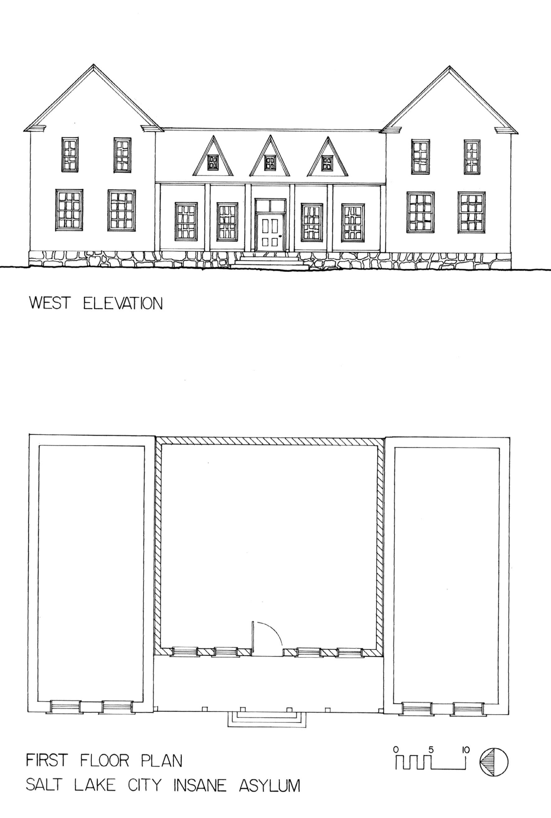
150 UHQ I VOL. 90 I NO. 2
UHQ 90_2 Text.indd 150 4/8/22 1:36 PM
Figure 1. The west elevation and first floor plan of the Salt Lake City Asylum and Hospital, as depicted by the author. A contemporary account of the facility described a building that covered an area of sixty-nine by forty feet. Its main building was a story-and-a-half high and thirty-three by forty feet. Two wings flanked the main portion, each two stories high and eighteen by forty feet. Drawing by Laurie J. Bryant; ink by James Gosney. Courtesy of Laurie J. Bryant
The Salt Lake City Asylum and Hospital, 1870–1886: Mental Illness in Early Utah
BY LAURIE J. BRYANT
In the late nineteenth century, psychiatry was gradually beginning to be recognized as a medical discipline in Europe and in the more progressive “insane asylums” in the eastern United States. Derisive terms such as crazy, maniac, insane, madman, and lunatic were in common use to describe and disparage the mentally ill, but they did not appear in Utah newspapers until 1868, when Joseph Sherman, said to be a boot-maker from Canada, had already been jailed for nearly a year in the basement of city hall.
Without offering any details, the Deseret News reported that Sherman had been “arrested as a maniac” in June of 1867 and simply held in jail. When he was brought before Judge Thomas J. Drake on April 14, 1868, Sherman refused to answer any questions, called the judge “a d____d old humbug,” and then tried to escape. Captured and brought back, he was returned to jail. The city attorney, Hosea Stout, stated that Sherman was “not fit to be at large” and petitioned the judge to “have him taken care of.”1
But what did that mean? There were no laws in Utah Territory regarding civil commitment until 1886, after the large Territorial Asylum opened in Provo, and no record of Sherman’s arrest or trial in any criminal court exists, not even a guardianship established through the probate court.2 As a perceived risk to public safety, Sherman was returned to his cell. He would not see daylight for another nine years.
In 1867, most people in the United States still lived east of the Mississippi and Missouri rivers, and in 1870, after more than twenty years of in-migration, even Salt Lake City’s population was no more than eighteen people per square mile.3 Almost everyone had made the journey west in wagons, buggies, and handcarts. Some of these latecomers were sick, and a few were labeled “insane” or “idiotic.” If they had no family to care for them, there was no place for them except on the streets or perhaps in jail. The 1860 United States Federal Census was the first to include a column to be marked for those who might be “deaf and dumb, blind, insane, idiotic, pauper or convict.” Only about twenty people in Utah Territory fell
151 UHQ I VOL. 90 I NO. 2
UHQ 90_2 Text.indd 151 4/8/22 1:36 PM
into these categories, and all lived with their families.4 There were no institutions to care for them and no laws governing their care, as there had been in the eastern United States.
The great breakthrough in travel came when the transcontinental railroad was completed in 1869. A year later, the Utah Central Railroad, promoted by Brigham Young and other leaders of the Church of Jesus Christ of Latter-day Saints, linked Salt Lake City to Ogden and thus by rail to both East and West Coasts.
Efficient travel provided many benefits. Immigrants no longer had to spend months on the trail, enduring bad weather, accidents, illness, and exhaustion. For the price of a railroad ticket, sometimes borrowed from the church’s Perpetual Emigrating Fund Company, and a few days’ time, whole families could arrive safely with all their belongings in what the Latter-day Saints called Zion. Commercial goods that had been very costly to haul for over a thousand miles could be shipped quickly and easily, making them cheaper and more abundant. The pioneer era was over.
But along with the welcome trainloads of Mormon pioneers came an influx of itinerant individuals—called wayfarers or strangers—who had no ties to the LDS church or to families who had arrived earlier. Salt Lake City, and for that matter Utah territory, were left to deal with the unanticipated consequences of this influx.
The Deseret News reported on February 3, 1869, that a petition had been sent to the Territorial
Legislature, requesting an appropriation for an insane asylum. Joseph Sherman’s fifteen months in the city jail was cited as part of the rationale.5 In the legislature, the House Special Joint Commission recommended that $10,000 be appropriated, if Salt Lake City and Salt Lake County would “appropriate $20,000, or see that the same is raised from other sources.”6 Two days later, on February 19, 1869, a line item in the Territorial Assembly’s budget read, “To be drawn by Salt Lake City to assist in erecting an Insane asylum and Hospital, [$]5000.00.” For only half the requested amount, the institution would then be expected to carry out a second major function.7
An “Asylum and Hospital” would be an answer to a social problem that weakened the safety and economic order of the territory. Whereas the other immigrants felt threatened by Native Americans, wild animals, capricious weather, and food shortages, those who could not contribute to the economy had to be controlled but also cared for, usually by law. This approach had been used since the seventeenth century in Massachusetts, where laws referred to “distracted persons” and “idiots.”8
Mental hospitals had a long history in the United States by 1869, beginning in 1770 with the opening of what was later called the Virginia Eastern Asylum at Williamsburg. The earliest institutions were simply holding facilities meant to house the mentally ill and those with developmental delays whose families were unable to care for them. But by the early nineteenth century, the expectations for many public and private
The east façade of the Pennsylvania Hospital for Mental and Nervous Diseases. The grandeur and serenity idealized in this image represented a standard for nineteenth-century asylums. The Salt Lake City Asylum and Hospital decidedly did not adhere to this ideal. W. E. Tucker, printer, undated (nineteenth century). Courtesy Library of Congress HABS PA, 51-PHILA, 511—10.
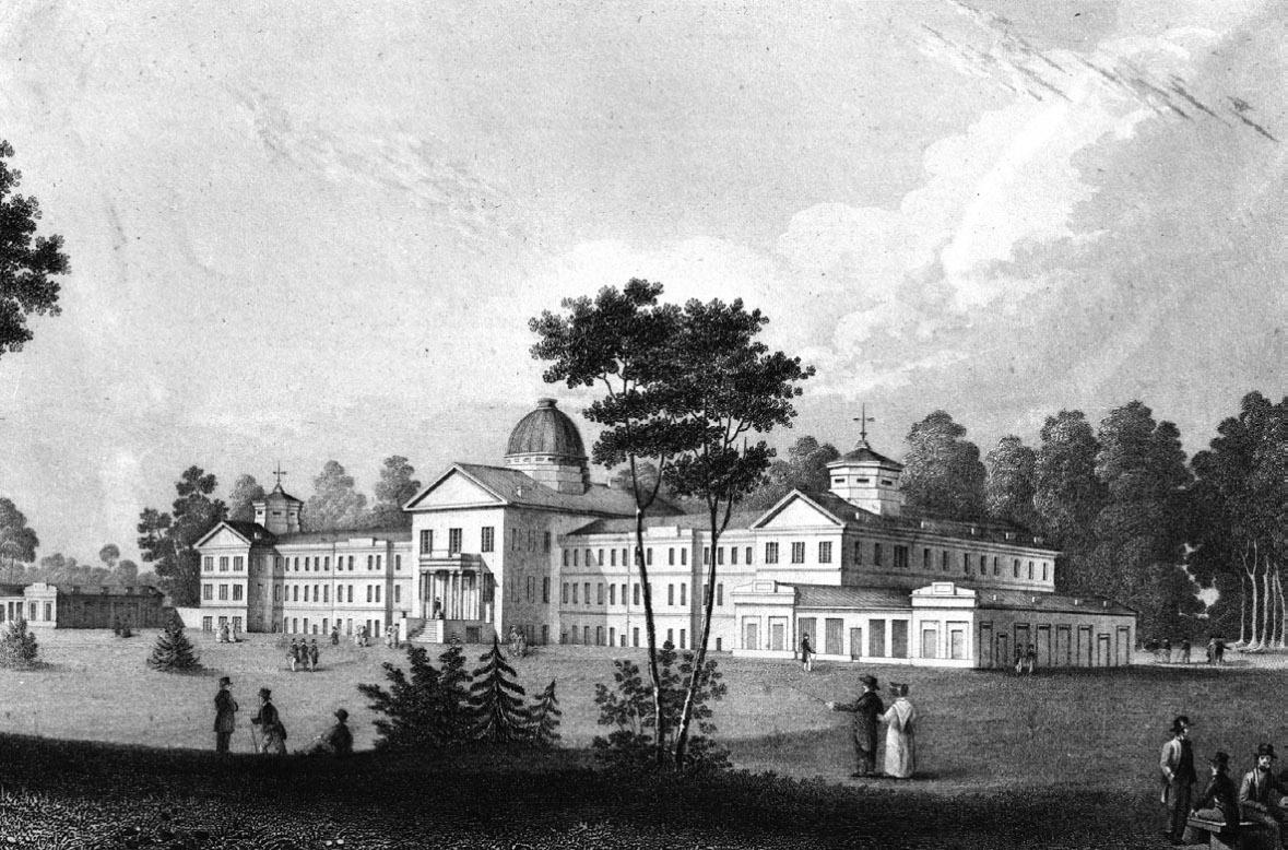
152 UHQ I VOL. 90 I NO. 2
UHQ 90_2 Text.indd 152 4/8/22 1:36 PM
asylums had changed dramatically. Charities, legislators, and city governments prescribed and built institutions of all kinds—poor houses, reformatories, prisons, and insane asylums—to revive what they fondly recalled as the enviable traditions of the colonial period, and to return all citizens to peaceful and productive lives. At the same time, religious groups such as the Quakers and Shakers, influenced by the period of Protestant religious revival known as the Second Great Awakening (1790–1840), were creating institutions that, while rigid in their concept and practices, nonetheless included what was known as traitement moral. 9 The term in English actually meant “a benevolent approach to care-taking.” Thomas Story Kirkbride (1809–1883) spent his forty-year career at the Pennsylvania Hospital for the Insane attempting to cure patients through the architectural designs of asylums: their windows, corridors, and novel ventilation systems.10 One approach that was thought to elicit a cure, or at least improvement, remained in favor—a peaceful setting where, removed from visitors, from the noise and distractions of city life, and from all that had been familiar but upsetting, inmates would at least become more tractable.
Utah’s first mental institution is generally understood to be the Territorial Insane Asylum, a sprawling building in the Richardsonian Romanesque architectural style. It opened in 1885, on the east side of Provo. It was not. In fact, the first asylum was a much less imposing stone and frame structure, only a few miles from the center of Salt Lake City. When the facility opened in 1870, reaching it required a difficult ride uphill, to a spot high on the western slope of the Wasatch Mountains on what was then, and now, known as the East Bench. Its nearest neighbor was a farmhouse more than half a mile to the west.
The original Territorial Insane Asylum at Provo was demolished between 1976 and 1981 and replaced by a group of smaller residential and administration buildings.11 But the fate of the Asylum and Hospital at Salt Lake City? That is a much more complex question. It is not shown on any known map. There are no known drawings, other than a tiny, indistinct image on a featureless plain.12 In the 1870s and 1880s, early photographers—Charles R. Savage, Andrew J. Russell, Edward Martin, Charles W. Carter,
and many others—made thousands of images of Salt Lake City while the hospital was being built and in use. Yet not one photograph of the building or its surroundings, only four miles from the center of town and virtually on the Mormon Trail, is known to exist.13 That lack of documentation has caused a great deal of confusion about where the place was and even doubts as to whether it existed at all. Its location, adjacent to the well-traveled route along Emigration Creek, and the prominent references to it in city newspapers, should have left no doubt about its presence.
Fortunately, the Salt Lake Telegraph printed two descriptions of the Asylum and Hospital building, one in the fall of 1869 while construction was underway and the following one in April 1871, about a year after its completion. The facility’s main portion was flanked by two wings, each two stories high. The Telegraph’s reporting on its structure conveyed both a perception of the patients’ behavior and how that behavior would be treated. “The building contains in all seventeen apartments, some with strongly fastened doors and windows, but well-lighted, roomy and comfortable, where occasionally patients have to be kept when they are unusually refractory. Other rooms for dormitories are neat, comfortable and inviting. . While looking out on the West from the front side of the building are a couple of apartments for the use of the patients when rational.”14 (See figure 1.)
Had the designers and builders understood and incorporated the lessons learned by doctors and asylum superintendents from coast to coast during decades of experience? The Association of Medical Superintendents of American Institutions for the Insane (AMSAII), organized in 1844, circulated among its members the developing trends in architecture, particularly the shift from the large Kirkbride-style asylum toward cottage-type housing arranged to simulate a village, along with their practices of moral treatment.15 But it appears that Salt Lake City’s institution had little in common with either of those widely used forms. What was there about its design that the city felt would be appropriate for someone like Joseph Sherman? Since it was meant to serve as both asylum and hospital, how had it been designed to serve two very different groups with different needs, in a single limited space?
153 UHQ I VOL. 90 I NO. 2
UHQ 90_2 Text.indd 153 4/8/22 1:36 PM
Along with its fences, outbuildings, fields, and nearly all the official records that might have been kept, the Asylum and Hospital is long gone. Its history has been so poorly documented that even people who should have known exactly where it stood seemed only to be guessing. A publication by the Daughters of Utah Pioneers placed it where a Catholic women’s school, St. Mary of the Wasatch, was built in the 1920s, northeast of the school’s stone entrance gates that are still standing near 1300 South and 2640 East streets.16 Later, Charles McKell, then the director of social service at the state hospital in Provo, offered two possible sites, one at about Twenty-fourth East and Ninth South, and the other, again, near St. Mary of the Wasatch.17 The actual location, quite plainly given in the 1870 ordinance establishing the Asylum and Hospital, is nearly a mile from either of those suggested locations.
In fact, the Asylum and Hospital was close to streets and places that are well known in Salt Lake City today. It faced 1300 South Street, perhaps 200 yards north of where that crosses Wasatch Boulevard. The land there is still city property, at the south end of the Bonneville Golf Course and slightly west of the tennis courts. A small area of level terrain there is exactly where county property records, and the city ordinance of 1870, placed it. Later records refine its location further, reflecting the whittling down of the boundaries by subsequent buyers and sellers.18
An even more persuasive clue is the presence of black locust trees (Robinia pseudoacacia) between the golf course and 1300 South. Some of the first pioneers brought black locust seeds to Utah Territory to act as “early successional plants,” trees that would grow in full sun where few others would, and rapidly. Their thorns and overly abundant blossoms make them unpopular today, but black locusts were specifically named in an early description of the asylum and its grounds.19 A small tree at the south boundary of the Bonneville Golf Course, and a dense cluster of large trees on a nearby private property, are likely the descendants of the original plantings.20 Rarely seen in Salt Lake City today, there are no other black locust trees in the surrounding area.
With its approximately 12,000 inhabitants, Salt Lake City was the largest population center in a
sparsely settled territory in 1869. It was also the center of newspaper journalism, the principal medium for large-scale information sharing at the time. Events at mental institutions were a popular topic in Utah newspapers and, presumably, with their readers. In the thirty-two years between 1853, when the first such article was printed in the fledgling Deseret News, and 1885, when Utah’s Territorial Insane Asylum opened in Provo, over 1,500 articles, notices, and advertisements about asylums in the United States and worldwide appeared in Utah newspapers. Often the focus was on tragedy—fires and inmate deaths—but it would be false to claim that local residents were ignorant of these institutions. They could even have known about the town of Gheel, Belgium, where for centuries residents accepted the mentally ill to live among them, participating in a community approach that was more quiet inclusion than therapy.21
At the City Council meeting on August 10, 1869, plans and specifications for the building were presented, along with the understanding that it would be built somewhere on the “Quarantine Grounds,” a large area that extended southeast along the Wasatch foothills from the mouth of Emigration Canyon. Council member Alonzo Raleigh, a mason by trade, was “added to said committee for the special purposes of [the building’s] erection.” Raleigh, who expected to leave on a mission for the LDS church to the East in October, wasted no time.22 By September 19, the facility was under construction, long before the land had been legally purchased from its owner. In a confusing sequence of transactions, Salt Lake City mayor Daniel H. Wells had paid $209 for the land in December 1869, although the seller, George Peterson, did not actually receive the patent or title from the federal government until November 1871.23 The building was probably complete before the ordinance identifying it as proposed was passed by the city council on February 8 and printed in the Deseret News on February 23, 1870.24
On the day the Asylum and Hospital was completed, a distinguished group of city and religious leaders, including Wells, Brigham Young, Wilford Woodruff, and Judge Elias Smith “proceeded in carriages from the City Hall to the Asylum, located about four miles E. S. East from the point of starting, on the bench between Emigration and Parley’s canons, on
154 UHQ I VOL. 90 I NO. 2
UHQ 90_2 Text.indd 154 4/8/22 1:36 PM
a very elevated and pleasant site.” A dirt road, described as “rather rough, somewhat crooked, and very dusty” led to an unsteady bridge across Emigration Creek and from there to the asylum’s north gate. The group “assembled, sang a hymn, knelt in prayer, and dedicated the grounds, the building and appurtenances to God, for the purposes for which they were designed.” They did not go inside.
The group then drove “about three-quarters of a mile east to the [new] Quarantine Hospital.” Known as the “Pest House,” it was not so much a hospital as a prison, built with a single purpose—to isolate those with infectious diseases who had no family or friends to care for them—and part of a longstanding practice in the United States and elsewhere. Its spring was another quarter-mile east, and from there most of the men went back to the city. A few returned to the asylum to spend more time observing the building’s exterior, remarking on the trees recently planted around it—all somewhat thinned or killed outright by grasshoppers—and its small expanse of farmland.25
Because 1870 was a census year, at least a partial list of the first patients’ names exists. The census listed Sarah Meyers, Alice Nuttall, Emma Walveton, and Alice Weiter, and described them as “insane.”26 With the patients, in the census, was the Peterson family: the steward, George, who had sold this land to the city, his wife Jacobine, and their children.27 The ordinance establishing the Asylum and Hospital provided clear instructions for record keeping, stating that the steward “shall also keep a book or record of the Asylum and Hospital, entering therein the name, time and place of birth, so far as can be ascertained, date of entrance, date of discharge or death of any inmate.”28 If Peterson and his successors followed this directive, the records have been lost.
By June 1870, the city had appointed Jeter Clinton as the institution’s physician and Theodore McKean as its superintendent, both of them recognized local men.29 Clinton’s only apparent qualification for the position was that he had been a druggist.30 McKean apparently had little direct contact with patients or staff, but he did report to the Territorial Assembly in 1872 that “the building of the City Asylum and Hospital commenced in the fall of 1869 and was erected
under the auspices of the City Council of Salt Lake City at a cost of $15,054.89.”31 The Asylum and Hospital accepted patients not only from the local area but from anywhere in the territory. It functioned as a charity hospital, but as McKean reported, “The expense of keeping the patients has been assumed in some instances by their friends, in others by the several counties where they resided and by the Corporation of Salt Lake City.”32
With the limited information kept by staff, much of what is known about the patients must be drawn from newspapers and the Salt Lake City Record of the Dead, which reported the place of death simply as “Asylum.”33 The first patient to die was James Pettit, who was born in Nauvoo, Illinois, and came to Utah as a child in 1850. He had been “kept at the City Asylum . for about a year, being subject to fits” (epilepsy) when he died in December 1871.34 His death was followed by those of Joel Wood, a pioneer of 1866 who died of chronic diarrhea, and John Pouder or Powder, a middle-aged man who died of “inflam. Brain producing Insanity” and was buried in the “Potters field.”35 Henry Stocks arrived in the Salt Lake Valley from England in 1855. In 1856, Stocks admitted to Brigham Young that he had begun experiencing fits, but he became a member of the 48th Quorum of the Seventies nonetheless. Stocks became progressively more tormented, apparently causing such disruption that his wife Mary refused to live with him. He died in convulsions and was buried in a pauper’s grave in April 1873.36
The personal tragedies of people such as Powder and Stocks occurred amidst the close and often tense setting of Salt Lake City in the 1870s. Three newspapers shared prominence in the city at that time: the Deseret News, the Salt Lake Herald, and the Salt Lake Tribune. The first was published by the LDS church, the second was owned by church members and reflected the views of the Deseret News, and the third was a virulently anti-Mormon paper owned, at the time, by a Kansas businessman. The papers began a proxy battle over the asylum in 1873, centered on Joseph Sherman. The Herald led off in May 1873, giving a favorable review of the building and grounds “in a healthy and pleasant location. The building is kept clean, the yard for recreation is large, and the keepers
155 UHQ I VOL. 90 I NO. 2
UHQ 90_2 Text.indd 155 4/8/22 1:36 PM
humanely disposed.”37 The Salt Lake Tribune responded in September with “A Terrible Case of Suffering,” raging against the treatment of “J. Sherman,” who was still confined in the “living tomb” of the city jail after more than five years, never allowed to see daylight or any face other than his jailor’s.” “The authorities,” wrote the newspaper, were unwilling to put Sherman in the asylum, “because the building is too fragile to restrain his violence.”38
Having someone committed to the asylum was quite informal and, again, reflected the circumstances of contemporary Salt Lake City; before 1886, when the territorial legislature passed a suite of laws regarding commitment, treatment, and release, no legal process seems to have existed for commitment.39 Sometimes the action took place in a city justice or alderman’s court. Perhaps most often, an unruly person like Sherman was simply arrested and sent to the asylum from the jail or prison. Annie White presented such a case. Reportedly, White had shot at her husband and, for some months, had roamed the city in a “demented” state. Then in May 1874, she “threatened to take the life” of a woman raising one of her children, “going to the house with a pistol and knife.” The Salt Lake Herald noted her arrest by the police and that she would “doubtless be sent to the insane asylum.”40 White was sent to the facility and, four years later, played a very sad part in its history.
The experience of Susan Vance presented a similar situation, but one complicated by race. As a Native woman who lived a public life in a downtown slum, Vance received no respect from the press, which reported somewhat frequently about her run-ins with the city authorities. One of those authorities was—problematically— Jeter Clinton.41 Clinton had many roles in Salt Lake City including city alderman, justice of the peace, quarantine physician, and physician at the Asylum and Hospital.42
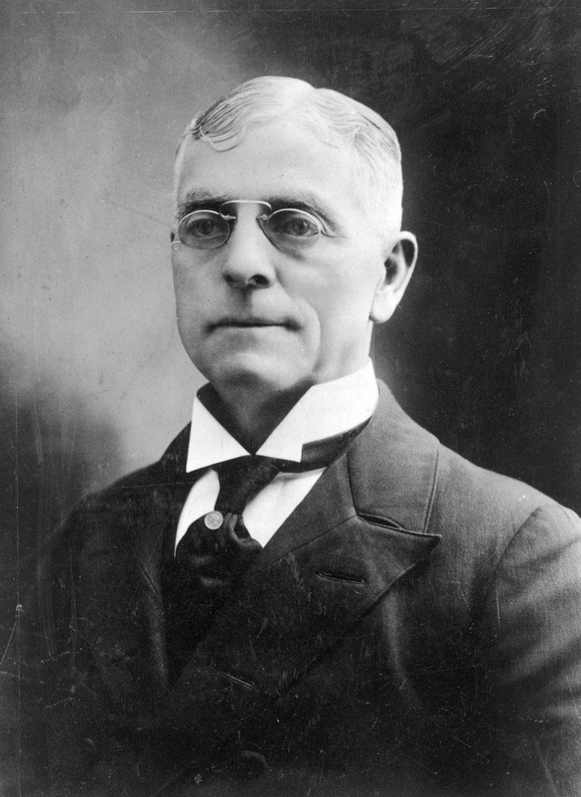
In December 1873, Vance fired a six-shooter in her Commercial Street dwelling, prompting the police to jail her. When she appeared in court, it was before Clinton, who let her off with a small fine and “an admonition . . . that if she was brought before him again on a similar charge he would recommend that she be taken to the lunatic asylum.”43 Clinton’s multiple positions in city government apparently allowed him to
pass judgment on individuals he saw in police court—essentially sending himself patients; acting as their caretaker; and, perhaps, being paid by the city for both roles. The following April of 1874, the Deseret News briefly mentioned Vance’s commitment to the institution, where she resided throughout the summer and which released her for showing improvement; by that October, police officers had picked Vance up again and returned her to the asylum.44 Thus, people like Annie White and Susan Vance, seen as troublesome by at least some of their fellow citizens, could be quite casually committed to the asylum, at times by a man who had a conflict of interest, to say the least.
Jeter Clinton resigned his city positions around August 1874, including as asylum physician, and moved on to operating his resort at Lake Point.45 His replacement was Seymour Bicknell Young, a nephew of Brigham Young. Sent to New York for medical training, Seymour Young returned to Utah in 1874 and stepped into the asylum position, while also maintaining a private medical practice and holding important positions in the LDS church.46 Young made an offer to buy the facility from the city in 1876, and failing that, leased it for twenty dollars a
156 UHQ I VOL. 90 I NO. 2
UHQ 90_2 Text.indd 156 4/8/22 1:36 PM
Seymour B. Young. Utah State Historical Society, photograph no. 14325.
month.47 In his diary, Young reported visiting the asylum on April 30, 1876.48 A few days later, he attended to Sam Rogers, a worker at the city jail, who had been stabbed in the chest with a knife attached to a broomstick.49 Joseph Sherman, still waiting to be moved to the hospital, had made the weapon and used it. After ten years in the city jail, Sherman was finally moved to the Asylum and Hospital in July 1877, where he would be kept in a cage in the building’s yard for another eight years.50
In the early nineteenth century, removing the patients from family and friends, from business and other cares, had been thought the first and most important element of a cure. Visitors were prohibited. Although the early asylums had only limited success in returning patients to anything like a productive or even a peaceful life and although asylum conditions generally devolved throughout the United States with the passage of time, some did operate with that humanitarian purpose in mind.51 Things were different at the Asylum and Hospital, where visitors, including newspaper reporters, were common. There was even a visitor register in Dr. Young’s office, indicating that the earlier prohibition had not only been abandoned but refuted. Men’s and women’s rooms were no longer in separate areas but directly adjacent. In the fifteen rooms there were nineteen patients, some admittedly sick rather than insane, some hobbled or caged.52
At least twenty-one asylum patients died between 1873 and 1878, among them Louis Bertrand, the first French convert to the LDS church, who had translated the Book of Mormon.53 The details of some of these deaths make it clear that the asylum had taken on many types of patients, including the infirm, community outsiders who were sick, and the elderly. George Straus, a German noted as a stranger in the city’s death record, died in the fall of 1873 of consumption and was buried in an unmarked grave. William Pugh, meanwhile, had all the toes on his right foot amputated after they were frozen; it is likely that a post-surgery infection killed him in April 1874. And Elizabeth Savagar Cole, who had given birth on a ship leaving from Liverpool and crossed the plains in 1853, died twenty years later at the institution of “General Debility.”54
Of the eight deaths in 1878 alone, those of Annie White and Mercy Hodgson Robinson provoked outrage and an investigation by a grand jury. Since about 1867, Robinson had lived in a small adobe house shaded by the city wall, which ran along what is now Fourth Avenue, near where it crossed City Creek. The house is still there, at 177 C Street.55 By the winter of 1878, however, she lived at the asylum, sharing a partitioned room with White. Both women died in a fire in the early morning hours of December 9, 1878, that engulfed their two rooms and dropped flaming embers into the one below. The institution had been full of visitors that day and what supervision might have been given by the steward, George Peterson, proved inadequate. White burned to death, her body “literally charred.” Robinson probably suffocated. The Deseret News speculated that the fire started when a visitor dropped a match, “or that a match was given to her by some one.” A coroner’s inquest, held before George Taylor, exonerated both Seymour Young and George Peterson from the blame of the deaths—but it also insisted that visitors receive written permits from the physician.56
Those findings must not have satisfied the larger community. The Third District Court of Utah Territory impaneled a grand jury in February 1879 to look into the asylum, among other matters; its findings were published by the local press in April.57 While the language of the grand jury report was restrained, its conclusions were damning. The details it revealed—that there were hospital patients among the insane, that the physician made only occasional visits, that the building and grounds, like the plan of management, were inadequate, and that the “contract system upon which it is conducted is open to objection as exposing helpless creatures to the cupidity of private interest”—exposed the deep flaws in Young’s management, supported by public funding.58 Even the Deseret News printed the report, verbatim.59 For his part, Young never mentioned the fire, the patient deaths, or the grand jury’s reports in his diary.
After leasing the asylum from the city for more than three years, Young made an offer to buy it outright in November 1879 for five thousand dollars. The city council consented, with the provision that Young would care for Sarah
157 UHQ I VOL. 90 I NO. 2
UHQ 90_2 Text.indd 157 4/8/22 1:36 PM
Meyers at no additional cost. He made the first payment of one thousand dollars, the rest to be paid quarterly at 10 percent interest.60 This occurred despite another grand jury report, published in the local press a few days later, which described Young’s institution as inadequate and even inhumane.61
Deaths at the Asylum and Hospital continued. As the years passed and the oldest patients aged, at least eighteen of them died there. Even members of prominent families, whose names are recognizable to any Utah historian, were sent there as developmentally delayed or “idiotic” persons. Jacob Reese Kimball, the son of Heber C. and Ruth Reese Kimball, lived as a child and teen with his family. The first cryptic mention of his residence at the asylum was an 1875 notice asking that citizens watch for “a demented young man . who answers to the name of Jacob.” He died at the asylum about a month later, with no cause of death provided, and was buried in the Kimball-Whitney family cemetery.62 John M. Bernhisel, meanwhile, was a well-known and highly placed physician and political figure. The 1880 census identified Bernhisel’s son William and daughter Cora both as “idiotic.” William was sent to the asylum, where he died of “softening of brain,” while Cora remained at home for many years and later lived in the Salt Lake County Infirmary and Hospital. When Cora died in 1940, she had been institutionalized for thirty years. Both are buried near their father in the Salt Lake City Cemetery.63 Unlike Kimball and the Bernhisels, most of the deceased were without family or friends in the territory, some of them known by a first name or surname alone.
Amidst the struggles and inadequacies of the Asylum and Hospital, some local voices began to call for the creation of a larger public institution. Without preamble, the Salt Lake Herald reported a brief statement Daniel Wells made before the legislature in early February 1880. He presented a resolution for a committee to look into the need for establishing a territorial asylum and hospital, “and for sanitary purposes generally, which was adopted.” The Territorial Legislature agreed and appointed a committee. Elsewhere in that day’s edition, the Herald editorialized that the lack of a publicly funded asylum in the territory “certainly
reflects otherwise than creditable. . Humanity demands that a place for the afflicted be provided.”64 Wells then shepherded the resolution through the Territorial Legislature, with several readings and amendments, resulting in its passage.65 Wells had been the mayor of Salt Lake City from 1866 until 1876, but by 1880 his principal role in government was as a member of the Council in the Legislative Assembly. In that office, he might have felt an obligation to enlarge the territory’s role in providing and funding an asylum for all its residents. Bills from the asylum, submitted to the City Council, had averaged more than five hundred dollars per month for years, even when few patients were confined there. The Legislative Assembly had often supplemented those appropriations as more patients were admitted from counties outside Salt Lake.66
Once the push for a territorial asylum began, it simply accelerated. By March 1880, a board of directors for the future hospital had been established.67 Within a few months, the board had chosen four counties where the new asylum might be located.68 Salt Lake County was quickly ruled out as a possible site, in spite of support from the Salt Lake Herald, following the objections of at least one man, who wrote to the Herald that he and others “would always vote against Salt Lake County as long as there was a chance of it being erected” on “the grounds owned by Dr. Young.”69 Finally, the commission selected a site just east of Provo for what would become the Utah Territorial Insane Asylum.70
Without a word to his diary, Young sold the old asylum and its eighty acres of land back to the Salt Lake City Corporation in May 1882 for one thousand dollars, one-fifth of what he had paid for it.71 Even so, he still listed that land as part of his assets in his diary at year’s end.72 Not so much as a notice appeared in the local newspapers, and there was no discussion of such a transaction in city council minutes. Dr. Young might simply have seen the whirlwind coming and chose to get out of its way.
The whirlwind was not far away. With the knowledge and permission of Governor Eli H. Murray, the Asylum and Hospital received a visit from Dr. George A. Tucker in August 1882. Tucker was an Australian physician and asylum manager on a tour of such institutions
158 UHQ I VOL. 90 I NO. 2
UHQ 90_2 Text.indd 158 4/8/22 1:36 PM
in England and the United States. Tucker’s inspection of the facility on August 22, 1882, and his report issued the following day, prompted a flurry of articles in the Salt Lake Tribune and the Deseret News. Both newspapers again printed their long-held and opposing views, the Tribune first pointing out that Tucker was there at the request of the governor. On the following day, having seen Tucker’s report, the Deseret News hastened to reject all of Tucker’s findings, sending its own reporter to collect a more flattering set of data. The Tribune, for its part, printed Tucker’s full report, followed by an article questioning how the asylum could be described as private when it had from the beginning been supported by such large appropriations from the city, the territory, and other counties.73
Tucker’s report was more detailed and strongly worded than anything the Tribune had published on the institution. The Tribune even suggested in a subtitle that “The Penitentiary the Place for Dr. Seymour B. Young.” Tucker described the building as “a mere cottage” with broken windows surrounded by unkempt grounds. The nine female patients were kept in the “attic or roof” (it was, after all, only a one-and-a-half story building). The mattresses were filled with straw and “the bed clothing [was] disgustingly dirty.” Also on that floor was a barred room where a woman suffering from syphilis lay on the floor. In another room on the upper floor was “a violent man, who had during the past week destroyed his bedstead and utensils, the broken furniture still remaining in the room.” When Tucker visited, the man was in the yard with irons on his hands and feet.
On the ground floor, also in a cage, there was a man who spoke rationally to the visitors and told them he had only been outside once in the past sixty days because he objected to having irons on his arms and legs. Tucker continued, reporting that the chamber pots had not been emptied and the stench in the asylum was terrible. Outdoors there were four cages in a lean-to. In one of them was a single man “of fine proportions, clean and tidy in appearance, who had been there confined for seven years,” admittedly in the “cleanest and neatest part of the entire institution.” That would have been Joseph Sherman.
The steward, Richard McAllister, reported that Dr. Young visited only occasionally and, perhaps most tellingly, that there were no written records of any kind. McAllister also admitted that he sometimes beat the inmates with a cane and that they were admitted and released with nothing more than a “certificate issued by a county Probate Judge.”74 Tucker’s report simply cemented a decision that was already a fait accompli: construction and contracting for the new asylum at Provo was proceeding apace.75 The Deseret Weekly News had reported in May that “the south wing of the large insane asylum building at Provo is 15 feet above its foundation.”76
The failure and loss of the Asylum and Hospital was not Seymour Young’s only challenge in the 1880s. In 1867, Young had married Ann Elizabeth Riter, whom he called Lizzie. He wrote fondly of Lizzie and their children in his diary, and of taking them with him on his occasional visits to the asylum. Then in 1884 Young married a plural wife, Abbie Corilla Wells. Lizzie seems to have known nothing about this second wife until sometime in May 1884, when jealousy between his wives erupted.77 And that was only the trouble within the family. The worst would come in 1886, when federal marshals pursued Young, attempting to arrest him for polygamy under the 1882 Edmunds Act. He escaped through an upstairs window of his home via a ladder and ran, and the case was eventually dropped for lack of evidence.78
Enough of the Territorial Asylum in Provo had been completed by the end of July 1885 that many of the patients were moved from Young’s hospital for what was hoped would be improved treatment. On July 31, 1885, the Salt Lake Democrat reported that a large crowd had gathered at the Denver & Rio Grande Western Railway passenger depot near 600 West and 200 South streets. They had come to see “about twenty crazy men and women” en route to the new institution in Provo. In keeping with the style of the era, the Democrat described those twenty individuals in language that both pitied and grossly pathologized them. The newspaper described how “Sheriff Groesbeck, Alex. Burt and several keepers” accompanied the patients, who “rode through the city shackeled [sic] to the wagon seats. Some of them seemed conscious of going on a trip, and were delighted,
159 UHQ I VOL. 90 I NO. 2
UHQ 90_2 Text.indd 159 4/8/22 1:36 PM
slapping their hands, singing and expressing the happiness of children. . They were all put in a special car and hand-cuffed.” The Democrat focused its reporting on “the most central figure of the old troupe,” Joseph Sherman,
So long confined in the city prison. Sherman has been in close confinement for at least twenty years, and being a man of extraordinary strength, very few have dared to face him. To-day he looked like a chained lion, as he sat heavily shackled to the seat by his ankles and wrists. Heretofore, in moving him, a strong cage has been used, made of 4x4 scantling, bolted together with heavy iron bars, in which Sherman would be driven and locked up like a ferocious beast.79
Many in that crowd at the Rio Grande depot would have been there to see the unfortunates from the Salt Lake City asylum. Perhaps they had followed the years of newspaper reports proclaiming the early success and later the decline of what might have been a humane and curative setting. Perhaps the onlookers were
simply relieved that such people had been removed from their community or were convinced that the inmates deserved no better. What the crowd might not have known—unless they were readers of the Salt Lake Tribune was that not just the mentally ill but also the demented elderly and the developmentally delayed had endured their confinement in a prison-like setting where they might be caged, handcuffed, locked in filthy rooms, and given only two meals a day. Some of their family names—Kimball, Bernhisel—and some of their histories, had the onlookers known about them, would have shocked all but the most unfeeling.
The Salt Lake Democrat held out hope for the new hospital, writing, “At their new, elegant quarters they will receive so much better accommodations that those who are now suffering from the milder forms of mental disorders will have a better chance of being restored to a proper use of their faculties. From a knowledge of the institution, every reason leads to the belief that the patients entering that public asylum will receive the very best of treatment from the superintendent physician and attendants.”80
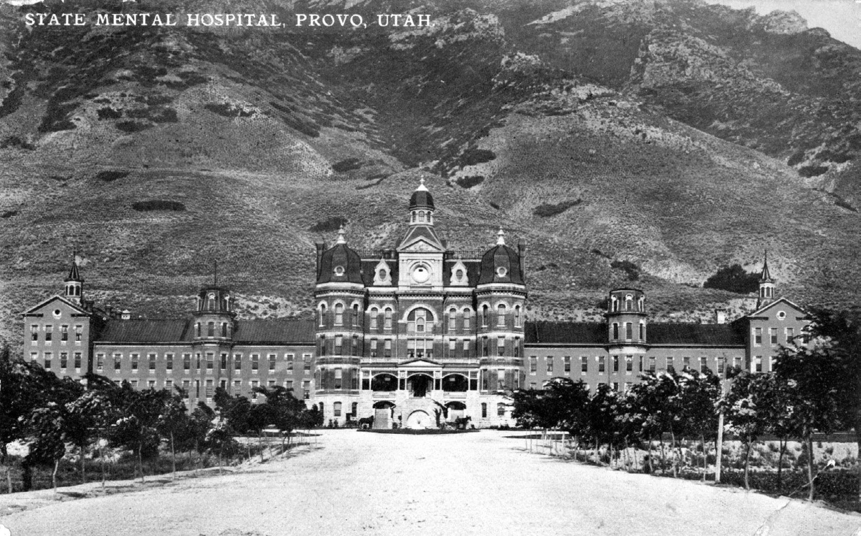
160 UHQ I VOL. 90 I NO. 2
UHQ 90_2 Text.indd 160 4/8/22 1:36 PM
A postcard depicting the Utah State Hospital in Provo, circa early twentieth centur‘y. A number of patients from the Salt Lake City Asylum and Hospital were transferred to the care of the Provo institution in 1885. Published by Souvenir Novelty Co. Utah State Historical Society, MSS C 376.
The old Asylum and Hospital building stood until at least 1891. It was said to have been “consumed by fire,” but no newspaper reported such an event. It might instead have been scavenged for building materials or collapsed under its own weight.81 Nothing remains of it at this date. In December 1885, only five months after the patients from Salt Lake City had arrived at the Territorial Asylum, a reporter from the Salt Lake Herald paid them a visit. He wrote that Joseph Sherman, “while in the Salt Lake Asylum, considered such a dangerous case, but who is now out with the others. On many subjects he is quite sane, and is one of the best patients.”82 When he died of influenza at the state hospital in 1901 at about age seventy-five, Joseph Sherman was hailed as “a model patient” who “did considerable work for the institution as a tailor and shoe-maker. He was a handsome and distinguished looking man and always scrupulously neat in his habits and attire . taking great pride in his appearance.”83
Appendix. Deaths at the Salt Lake Asylum and Burials in the Salt Lake City Cemetery
Notes indicate (where possible) the name of the deceased, death date, additional information, attending physician, and burial place within the Salt Lake City Cemetery. Compiled from Salt Lake County Archives, Death Record Search, slco.org/archives/vital-records/Death .aspx; Utah Division of State History, Utah Cemetery Database, utahdcc.secure.force.com /burials/; and other sources.
John Powder (or Pouder). June 1872. Death Record: “buried from Asylum, 1872, inflam. brain, Insanity.” Potter’s field (B-4-Pauper-456).
Jack Woods. September 1, 1872. No cemetery record. Death Record: buried “x City.”
Henry Hampton. June 19, 1873. Strangulation (hanged himself). From Isle of Man. Buried UK 2633. Salt Lake Tribune, June 21, 1873.
Johannes (or Johanna) A. Christensen. November 21, 1873. Fits. Plot E. Death Record: person no. 6063, p. 152.
Wallace McIntyre. March 26, 1874. No cause. Plat C? Cemetery Database: UK2878.
William Pugh. April 21, 1874. No cause. Death Record: Plot H 5. Cemetery Database: UK2903.
Joseph Livsey. September 4, 1874. Effects of light, sunstroke. S. B. Young. H-5-16-2E.
Louis A. Bertrand. March 21, 1875. Brain disease. S. B. Young. E-16-9–1E.
Harrison Stewart. April 1875. Death Record: buried Plot E. UK 3173.
Jacob R. Kimball. May 31, 1875. No cause. S. B. Young. Heber C. Kimball family plot. Deseret News, June 9, 1875.
Joseph Sherman. April 19, 1876. Lead poisoning, producing insanity. S. B. Young. UNK 3463.
Minnie Plume. May 17, 1876. Apoplexy. S. B. Young. Buried I-11–11–5W. “City Council,” Salt Lake Herald, July 12, 1876.
William Alfred Parks. March 12, 1878. Paralysis. S. B. Young, Plot C. Cemetery Database: K-13-7-1E.
Isaac Blizzard. April 19, 1879. “Insane patient from Tooele”; eighty-three years old. K-13-6-3 E (?). Death Record: Tier No. 3.
Annie White. December 9, 1878. Burned to death. S/2 block 13, 14W? Sch. No. 3 in Death Record. K-13-14-3W.
Mercy Robinson. December 9, 1878. Smoke inhalation. J15-11-2W.
L. V. (or S. V.) Winaus. July 15, 1879. Scrofula. Age thirtynine. S. B. Young. Death Record: L-11-4. Strangers. L-114-4W.
William Louis Goedert. December 23, 1879. Syphilis. From Germany. S. B. Young. Potter’s field. I-12-3-2W.
Ephraim Luce. March 2, 1880. Old age. Born September 1799, Maine. Arrived with James Cummings Company, 1851. S. B. Young. His children probably bought plot K13-13-3E.
Z. Anderson. May 30, 1880. Gangrene. From Finland; probably forty-nine years old. Potter’s field. I-12-4-4W.
Samuel Button. November 19, 1880. Paralysis. Born in Ohio. Brought from near Panguitch and thought to be fortyone. S. B. Young. Strangers. I-12-5-3W. See also 1880 Census.
Name unknown, “related to Swedishman,” Death Record. June 20, 1881. Brain disease, lead poisoning. Dr. Benedict. Strangers, L12-6-2E.
James Caddigan. June 28, 1881 Meningitis. About fifteen years old. S. B. Young. Cemetery Database: K-11-2-4W.
Joseph Davenport. July 4, 1881. Inflamed stomach. About thirty-two. S. B. Young. I-12-6-3E.
Louis Kimball. July 23, 1881. No cause. Perhaps forty; from Massachusetts. S. B. Young. L-12-6-2W.
Margaret Mantell August 2, 1881. No cause. From Switzerland; forty-one years old. S. B. Young. K-12-3-4W.
Mary Dale. August 9, 1881. Old age. Born in England; eightytwo years old. S. B. Young. K-12-4-3E.
Charles Davis. November 20, 1881. Heart disease. S. B. Young. Buried (?) I 13, Strangers. Cemetery Database: I-12-6-4W
William Barnes. October 2, 1882. Erysipelas. Forty-two. S. B. Young. UK 4852.
Samuel Vincent. October 23, 1883. Apoplexy. S. B. Young. Strangers. UK 4880.
Nancy Harmon. July 29, 1883. Old age. Eighty-two. S. B. Young. F-11–11–3W.
Nathan Thayer. November 2, 1883. Paralysis. S. B. Young. Potter’s field. B-4-pauper-133
William G. Young, December 26, 1883. Spotted fever. From Scotland; twenty-nine. Parents in Sevier County. S. B. Young. UK 5263.
Johannah M. Peterson. July 24, 1884. General paralysis. Wife of Peter; born 1826 in Denmark. S. B. Young. UK 5162.
Charles Ashbough. September 16, 1884. Softening of brain. Twenty-six? S. B. Young. Potter’s field. Cemetery Database: B-4-pauper_48.
Henry Allsworth. September 22, 1884. No cause. Born in 1825, England. S. B. Young. M-4-10-3-.
161 UHQ I VOL. 90 I NO. 2
UHQ 90_2 Text.indd 161 4/8/22 1:36 PM
William Henry Bernhisel. October 22, 1884. Softening of brain. Son of John M. Bernhisel and Elizabeth Barker. Born 1849. S. B. Young. B-15-10-5W.
Bernhard McMann. November 1, 1884. Paralysis. Sixty years old. S. B. Young. B-4-Pauper-409.
John Gange. July 18, 1885. Born in England, 1843. S. B. Young. Buried SK, SW xxd Church. Cemetery Database: UK 5656.
Mrs. Hanni. September 8, 1885. General debility. Born in France. S. B. Young. UK 5696.
Hannah Marsh. November 4, 1886. Softening of brain, insanity. S. B. Young. Death Record: S 1/2 xxx. Cemetery Database: UK 6043. This was after the asylum officially closed, but it appears that Young kept a patient or two after that date.
Notes
Much of the credit for this research must go to my colleagues W. Randall Dixon, Thomas Carter, the staff of the Utah Division of State History Research Center, the Utah State Archives and Records Service, and the very patient editors of the Utah Historical Quarterly. The Salt Lake Monument Company matched a grant I received from the State of Utah to create a monument in 2019 to patients who died at the Asylum and Hospital. I am most grateful to the staff of the Salt Lake City Cemetery, and particularly to the late Mark Smith, its sexton. My son Duncan was the inspiration for this work.
1. “Local and Other Matters,” Deseret Evening News, April 14, 1868. Judge Thomas J. Drake had been appointed by President Abraham Lincoln and was strongly opposed to the Latter-day Saints. Hubert Howe Bancroft, History of Utah, 1540–1886 (San Francisco, 1889), 610–611.
2. District Court (Third District) Territorial Minute Books, reel 1, box 1, vol. A (1858–1869), Series 1649; Salt Lake County Probate Record Books, Series 3372, both in Utah State Archives and Records Service, Salt Lake City, Utah (hereafter USARS).
3. Francis A. Walker, Map Showing, in Five Degrees of Density, the Distribution, within the Territory of the United States, of the Constitutional Population . 1870 (US Census Bureau, 1870), accessed November 10, 2021, census. gov/history/pdf/1870_Population_Density.pdf.
4. 1860 United States Federal Census, Utah Territory.
5. “Items,” Deseret News, February 3, 1869, 413.
6. “Legislative,” Deseret News, February 17, 1869.
7. Territorial Legislative Records, 1851–1894, p. 4555, Series 3150, USARS.
8. Gerald N. Grob, Mental Institutions in America: Social Policy to 1875 (New York: Free Press, 1973), 8.
9. Grob, Mental Institutions, 42.
10. Carla Yanni, The Architecture of Madness: Insane Asylums in the United States (Minneapolis: University of Minnesota Press, 2007) 24
11. Janina Chilton, “Reflections: A Photographic Essay of the Utah State Hospital,” Utah Historical Quarterly 78, no. 2 (2010): 152.
12. Eli Glover, Bird’s-Eye View of Salt Lake City from the North Looking South-east, Utah (Cincinnati: Strobridge, 1875), map.
13. Ronald L. Fox, personal communication with Laurie J. Bryant, 2017; W. Randall Dixon, “From Emigration Canyon to City Creek: Pioneer Trail and Campsites in the Salt Lake Valley in 1847,” Utah Historical Quarterly 65, no. 2 (1997): 157.
14. “Asylum for the Insane,” Salt Lake Daily Telegraph, April 27, 1871.
15. Grob, Mental Institutions, 332.
16. Frances W. Kirkham and Harold Lundstrom, Tales of a Triumphant People: A History of Salt Lake County, Utah (Salt Lake City: International Society Daughters of Utah Pioneers, 1947), 10:221; Alan Barnett and Shipler family, Seeing Salt Lake City: The Legacy of the Shipler Photographers (Salt Lake City: Signature Books, 2000), 135.
17. Charles R. McKell, “The Utah State Hospital: A Study in the Care of the Mentally Ill,” Utah Historical Quarterly 23, no. 4 (1955): 297, 303.
18. Title abstracts, N 1/2 SE 1/4, Section 10, T1S, R1E, Book A-3 p. 241, Book A-9 p. 50, Book B-3 p. 241, Salt Lake County Recorder, slco.org/recorder/.
19. “Asylum for the Insane,” Salt Lake Herald, April 27, 1871.
20. Other black locust trees were planted in the Fort Douglas Cemetery in 1864.
21. “Gheel—the City of the Simple,” Deseret News, July 14, 1869.
22. Alonzo H. Raleigh, Diary, (redacted), October 4, 1869, 129–30, 6172, Church History Library, Church of Jesus Christ of Latter-day Saints, Salt Lake City, Utah (hereafter CHL).
23. Title abstracts, Salt Lake County Recorder.
24. “An Ordinance, entitled, An Ordinance to establish a City Insane Asylum and Hospital was again introduced. The ordinance was read and taken up for second reading by sections. Several Sections were amended. The Ordinance was read three times. On motion of Councilman Davis [?] the Bill passed its third reading by a vote and became a law. On motion of H. Grow the Council adjourned.” City Council Minutes, February 12, 1870, p. 447, Salt Lake City (Utah), City Recorder Minutes, Series 82755, USARS; see also, “An Ordinance,” Deseret Evening News, February 17, 1870, 2.
25. “Correspondence,” Deseret News, July 6, 1870. For instances of pest houses, see Linda T. Austin, “Escape from the Asylum: The End of Local Care of the Mentally Ill in Memphis and Shelby County,” Tennessee Historical Quarterly 72, no. 1 (2013): 62; James Colgrove, “Immunity for the People: The Challenge of Achieving High Vaccine Coverage in American History,” Public Health Reports (1974-) 122, no. 2 (2007): 249; Wendy E. Parmet, “J. S. Mill and the American Law of Quarantine,” Public Health Ethics 1, no. 3 (2008): 213.
26. None of these women is included in the Pioneer Database, which lists members of the Church of Jesus Christ of Latter-day Saints who traveled overland to Utah Territory before completion of the transcontinental railroad, suggesting that they were, perhaps, “strangers.” Church of Jesus Christ of Latter-day Saints, Pioneer Database, 1847–1868, accessed November 11, 2021, history.churchofjesuschrist.org/overlandtravel/.
27. 1870 United States Federal Census, Sugar House Ward, Salt Lake, Utah Territory, roll M593_1611, page 532A, digital image, accessed October 28, 2021, ancestry.com.
28. “An Ordinance,” Deseret News, February 23, 1870, 7.
29. “Official Directory,” Salt Lake Herald, June 8, 1870.
30. For Jeter Clinton’s many roles, including his work as a druggist, see George Owens, Salt Lake City Directory: Including a Business Directory of Provo, Springville, and Ogden, Utah Territory, 1867 ([Salt Lake City]: G. Owens, 1867), 41, 108, 120, 121, 122.
162 UHQ I VOL. 90 I NO. 2
UHQ 90_2 Text.indd 162 4/8/22 1:36 PM
31. Utah Territorial Assembly, House Minutes, February 1–2, 1872, box 11, fd. 15, 00047 ff, item 2919, CHL.
32. “Insane,” Salt Lake Herald, April 21, 1880; “A Loose Danger,” Salt Lake Herald, April 21, 1882.
33. Salt Lake City, City Recorder Death and Burial Register, 1848–1933, Series 21866, USARS. Prior to 1872, this term referred only to the city Asylum and Hospital. Later, the name of the attending physician indicates whether a person died at the Asylum and Hospital or another place.
34. Pioneer Database, s.v., “James Richard Pettit,” accessed November 11, 2021; “Local and Other Matters,” Deseret News, December 6, 1871, 1.
35. Salt Lake County Archives, Death Record Search, s.v., “Joel Wood,” person no. 5316, p. 133, and “John Powder,” person no. 5162, p. 130, both accessed November 2, 2021, slco.org/archives/vital-records/Death.aspx. (qtns); see also Utah Cemetery Inventory, 1847–2000, and Salt Lake City, Utah, U.S., Cemetery Records, 1848–1992, both s.v. “John Powder,” accessed November 2, 2021, ancestry.com.
36. Henry Stocks, Diary, 1844–1870, MS 9516, CHL; Death Record Search, s.v. “Henry Stock,” person no. 5707, p. 143; 1870 United States Federal Census, Willow Creek Ward, Salt Lake, Utah Territory, roll M593_1611, page 546B, Henry Starks, accessed November 11, 2021, ancestry .com.
37. “The East ‘Bench,’” Salt Lake Herald, May 2, 1873.
38. “A Terrible Case of Suffering,” Salt Lake Tribune, September 16, 1873.
39. Legislature, Utah Code Annotated, 1888, vol. 1:693–713, Series 83238, USARS. No records held by the state archives refer to a legal process prior to 1888.
40. “Insane Woman,” Salt Lake Daily Herald, May 29, 1874.
41. “Court Proceedings,” Salt Lake Herald-Republican, September 3, 1873; “On the War Path,” Salt Lake Herald Republican, December 12, 1873.
42. See, for instance, “Official Directory,” Salt Lake Herald-Republican, December 11, 1872, September 6, 1873, April 25, 1874.
43. “Local and Other Matters,” Deseret News, December 17, 1873, 8 (qtn). For more on Jeter Clinton’s checkered career, see “To the Public, and Especially the Mormon Portion of It,” Salt Lake Tribune, February 16, 1872; Andrew Jenson, The Historical Record, A Monthly Periodical Devoted to Historical, Biographical, Chronological and Statistical Matters (Salt Lake City: Andrew Jenson) 5:320.
44. “Local and Other Matters,” Deseret News, April 8, 1874; “Insane Asylum Candidates,” Salt Lake Herald, October 24, 1874; Ogden Semi-Weekly Junction, October 24, 1874, 3.
45. “Out of Office,” Salt Lake Herald, August 1, 1874.
46. “Official Directory,” Salt Lake Herald, August 28, 1874; “Special Business Notices,” Deseret Evening News, June 23, 1876, 3.
47. Seymour B. Young, Diary, 1865–1885, March 22, 1876, November 19, 1879, p. 22, 114, MSS A 1755 Vault, Utah State Historical Society, Salt Lake City, Utah.
48. Young, Diary, 34.
49. Young, Diary, May 7, 1876, 35–36; “A Maniac Stab,” Salt Lake Herald, May 9, 1876.
50. “Joe Sherman,” Salt Lake Herald, July 4, 1877.
51. David J. Rothman, The Discovery of the Asylum: Social Order and Disorder in the New Republic (New York: Little, Brown, 1971), 127.
52. “The Asylum,” Salt Lake Herald, June 28, 1877.
53. “Local and Other Matters,” Deseret News, March 24, 1875.
54. Death Record Search, s.v. “George Straus,” person no. 5970, p. 150, “Pugh,” person no. 6266, p. 157, and “Elizabeth Coal,” person no. 5870, p. 147 (qtn.), all accessed November 1, 2021; “Local and Other Matters,” Deseret News, April 22, 29, 1874; Pioneer Database, s.v. “Elizabeth Cole,” accessed November 1, 2021. For other representative deaths, see Death Record Search, s.v. “Joseph Livsey,” person no. 6498, p. 163, and “Harrison Stewart,” person no. 6762, p. 170; “Local and Other Matters,” Deseret News, April 28, 1875.
55. Laurie J. Bryant, A Modest Homestead: Life in Small Adobe Homes in Salt Lake City, 1850–1897 (University of Utah Press, 2017), 189–91.
56. “Local and Other Matters,” Deseret News, December 18, 1878, 1 (qtns.); “Fatal Fire,” Salt Lake Daily Herald, December 10, 1878, 3.
57. “Grand Jury Work,” Salt Lake Tribune, April 10, 1879; “The Late Grand Jury Addresses the People,” Deseret Evening News, April 10, 1879; “It Might Have Been,” Salt Lake Herald, April 10, 1879.
58. “It Might Have Been,” Salt Lake Herald, April 10, 1879. The jury foreman was a mining manager named M. T. Burgess, almost certainly not a Latter-day Saint.
59. “The Late Grand Jury Address the People,” Deseret News, April 23, 1879.
60. Young, Diary, November 19, 1879, p. 114; “City Council,” Salt Lake Daily Herald, November 12, 1879, 3.
61. “Grand Jury Report,” Deseret Evening News, November 28, 1879; “Grand Jury Report,” Salt Lake Herald Republican, November 27, 1879; “The Asylum,” Salt Lake Herald Republican, November 30, 1879.
62. “Local and Other Matters,” Deseret News, April 21, 1875 (qtn.); 1860 United States Federal Census, Great Salt Lake City Ward 18, Great Salt Lake, Utah Territory, page 270, Jacob Kimball; 1870 United States Federal Census, Salt Lake City Ward 18, Salt Lake, Utah Territory, roll M593_1611, page 700A; Jacob Kimball; “Died,” Deseret News, June 9, 1875; Death Record Search, person no. 6820, p. 171; Utah, U.S., Wills and Probate Records, 1800–1985, s.v. “Jacob R Kimball,” Utah, Salt Lake County, Third District Court Probate Case Files, accessed November 9, 2021, ancestry.com, suggests this was a case of guardianship.
63. 1880 United States Federal Census, Salt Lake City, Salt Lake, Utah, roll 1337, page 123B, enumeration district 047, William Bernhisel and Cora L. Bernhisel (first qtn.); Death Record Search, s.v. “Wm Henry Bernhisel,” person no. 12354, p. 309 (second qtn.), and s.v. “Cora Bernhisel,” State of Utah Death Certificate, May 8, 1940; “Obituaries,” Salt Lake Telegram, May 11, 1940.
64. “The Legislature,” “Chips” (first qtn.), and “Insane Asylum” (second qtn.), Salt Lake Herald, February 7, 1880.
65. “The Legislature,” Salt Lake Herald, February 21, 1880, 3.
66. “Legislative Assembly,” Deseret News, February 23, 1876.
67. “Territorial Insane Asylum,” Salt Lake Herald, March 3, 1880.
68. “Territorial Insane Asylum,” Salt Lake Herald, April 9, 1880.
69. “Asylum Commissioners,” Salt Lake Herald, April 28, 1880; “The Asylum,” Salt Lake Herald, June 27, 1880.
163 UHQ I VOL. 90 I NO. 2
UHQ 90_2 Text.indd 163 4/8/22 1:36 PM
70. “The Insane Asylum,” Salt Lake Herald, August 6, 1881.
71. Title abstracts, Book A-3 p. 241, Book A-9 p. 50, Book B-3 p. 241, Salt Lake County Recorder.
72. Young, Diary, December 18, 1882, p. 169.
73. “Investigating Our Asylums,” Salt Lake Tribune, August 22, 1882; “Hell in Utah” and “The Insane Asylum,” Salt Lake Tribune, August 23, 1882; “The Asylum Again,” Salt Lake Tribune, August 24, 1882; Deseret News, August 22, 1882, 3; “Dr. Young’s Insane Asylum,” Deseret Evening News, August 23, 1882. See George A. Tucker, Lunacy in Many Lands (Sydney: Charles Potter, 1887), 549–50, for what appears to be the same report on the institution.
74. “Hell in Utah,” Salt Lake Tribune, August 23, 1882. Throughout the research involved in this work, I was unable to find any kind of asylum records concerning patient admissions, releases, or deaths. In the diary of Seymour B. Young, the only exception was the death of and inquest concerning William Graham Young in 1883–1884. Salt Lake City and County each maintained a Record of the Dead, from which I obtained the information here.
75. “Local and Other Matters,” Ogden Herald, August 28, 1882.
76. “Local and Other Matters,” Deseret Weekly News, May 24, 1882.
77. Young, Diary, May 24, 28, 29, 1884, p. 227–29.
78. “Dr. Young’s Escape,” Salt Lake Democrat, June 16, 1886; “No Evidence,” Ogden Herald, August 3, 1887.
79. “Unfortunate Humans,” Salt Lake Democrat, July 31, 1885, 4.
80. “Unfortunate Humans,” Salt Lake Democrat, July 31, 1885.
81. “Real Estate and Business Notes,” Salt Lake HeraldRepublican, January 25, 1891; Frances W. Kirkham and Harold Lundstrom, Tales of a Triumphant People: A History of Salt Lake County, Utah (Salt Lake City: International Society Daughters of Utah Pioneers, 1947), 10:221.
82. “The Territory’s Wards,” Salt Lake Herald, December 17, 1885.
83. “Provo,” March 23, 1901 (qtns.); “Local Briefs,” Deseret Evening News, March 21, 1901.
164 UHQ I VOL. 90 I NO. 2
UHQ 90_2 Text.indd 164 4/8/22 1:36 PM
REVIEWS
Reconstruction and Mormon America
Edited by Clyde A. Milner II and Brian Q. Cannon
Norman: University of Oklahoma Press, 2019. 270 pp. Hardback, $34.95
In 2002, then-president of the Western History Association Elliott West introduced the concept of “Greater Reconstruction.” West posited that while histories of nineteenth-century America were dominated by the nation’s westward expansion and the Civil War and its aftermath, the field might benefit from treating these simultaneous events as portions of one larger process of American nation-building that prioritized federal power and remade the United States. It has now been more than twenty years since West’s initial paper, and the concept of Greater Reconstruction has pushed the field in many interesting directions since then, opening the door to comparative scholarship that has expanded the historiography of Civil War era.
One of the fields that has most benefitted from this concept has been Mormon history, and Reconstruction and Mormon America is a perfect example. Originating from a seminar hosted by the Charles Redd Center at Brigham Young University, this edited collection is a meditation on the fields of Reconstruction and Mormon history, thoroughly considering the applicability of Greater Reconstruction in territorial Utah and thoughtfully comparing Latter-day Saint experiences with white and Black Americans in the U.S. South, as well as Indigenous Americans in the U.S. West.
The book consists of an introduction (appropriately written by Elliott West) and three main parts, each consisting of a short preface and three longer essays. The first section is the most contextual, focused on how assimilation efforts by the federal government in Utah fit in with state-building efforts elsewhere. Angela Pulley Hudson leads off, with a brilliant analysis of why there is no “Mormon Trail of Tears.”
As settlers themselves, Mormons were often the perpetrators and beneficiaries of settler colonialism, she says. Hudson also calls into question the value of the framework of Greater Reconstruction, because the comparison of Mormon and Indigenous assimilation efforts by the government obfuscates the unique brand of state violence against Indigenous peoples, in which “Mormons have been enthusiastic, if not always welcome, participants” (20). Christine Talbot comes next, focusing on Republican efforts to remake America’s social structure by not only abolishing slavery, but by remaking the nuclear family by eradicating polygamy and plantation-style patriarchy. She also makes insightful comparisons between the mid-nineteenth century concepts of free labor and companionate marriage. Patrick Mason finishes the first section with an analysis of “legitimate violence” and the state, concluding that Mormon Utah was subject to what he calls “disciplinary democracy,” which ultimately implied the religion’s eventual assimilability in the larger state, though it had to accept federal force for that to occur.
The next section is more specific to Reconstruction itself, with both Brett Dowdle and Brent Rogers arguing that Utah is a prime example of the development of federal supremacy in the post-Civil War United States. This applied to territorial administration and legislative action, as well as cultural and social pressures. Mormons, like other American “others,” were indeed subject to federal assimilation efforts, though there were differences in the groups. Rachel St. John, however, pushes against this conclusion, arguing that expanding the concept of Reconstruction to all assimilation efforts diminishes the framework’s usefulness.
The final section focuses on the legacy of Mormon Reconstruction, where the three authors (Clyde Milner, Eric Eliason, and Jared Farmer) ponder why there is no Mormon “Lost Cause” comparable to the legacy of the Confederacy in the southern United States. In all, the authors largely agree that Mormons have sidestepped the issue in many clever ways, such as
165 UHQ I VOL. 90 I NO. 2
UHQ 90_2 Text.indd 165 4/8/22 1:36 PM
prioritizing “pioneer” heritage in their commemorations, which situates them as agents of national development rather than dissatisfied refugees, or by truly giving up on the elements of their faith that were lost, such as polygamy.
In all, Reconstruction and Mormon America is an excellent collection that succinctly and cogently ties together many excellent stand-alone essays into an insightful historiographical reflection. Each of the essays would work well in undergraduate or graduate seminars, and the book as a whole is essential for any reader attempting to understand the current state of either Mormon or Reconstruction history. This is a solid contribution to the field.
–Reilly Ben Hatch University of New Mexico
Carbon County, USA: Miners for Democracy in Utah and the West
By Christian Wright
Salt Lake City: University of Utah Press, 2020. xlvi + 423 pp. Hardback, $45.00
In Carbon County, USA, the historian Christian Wright examines the history of labor organization in eastern Utah’s coal mining industry between the 1930s and 1980s. Split into three parts, the book first documents the period from the 1930s to the early postwar years, including the problems emerging in the United Mine Workers of America (UMWA). Part 2 chronicles the coal industry’s revival during the nationally and internationally tumultuous 1960s and when the UMWA encountered the rise of a competing union in 1970: Miners for Democracy. In the book’s final section, Wright dedicated one chapter each to race, gender, and generation, emphasizing the 1970s to 1980s period, which was also the decline of industry and organization. In the epilogue, Wright connects the preceding chapters to pending questions about the roles of coal and labor organization in the United States during the twenty-first century.
Wright’s argument is at least twofold. One argument is that labor history is still relevant and valuable. But Wright also argues that looking beyond the labor–management and
union–antiunion dichotomies to the nuances of labor organization demonstrates that union power’s decline in Utah’s coal industry resulted from fracturing union leadership and changing understandings of identity among rank-and-file workers. Integral to Wright’s study of identity are race, gender, and generation. While the first argument—the relevance and value of labor history—will speak mainly to an academic audience, the second will likely appeal to anyone interested in the histories of coal mining, Utah, labor organization, and identity studies.
In exploring the depths of labor organization in Utah, Wright’s book adds to several bodies of literature. For one, it is the most comprehensive examination of coal mining labor organization in Utah. It adds to a 2006 edited volume on Utah mining by examining eastern Utah over a fifty year period in particular. Additionally, Wright’s arguments about labor organization extend the chronology of most mining labor histories, which often analyze the pre-1930s period. In doing so, Wright’s work fills a gap but also demonstrates the value of learning from the decline of the movement, not just its heyday. Finally, labor history had its own heyday and has seen some decline, but Wright’s analysis reveals how labor history might add to ongoing political conversations.
Overall, this volume contains excellent prose, impressive research, and useful graphics, ranging from graphs and tables to historical images. The introductions to chapters 1, 2, 3, 5, and 6 are particularly noteworthy for their prose. Wright’s spread of records from the United Mine Workers of America and Miners for Democracy archives to local repositories, including museums and records in Carbon and Emery counties, expresses a deep engagement with the national and regional stories. Readers will surely appreciate the images contained throughout the text as well, including the maps at the front, the appendices (e.g., a timeline of regional and national events), and tables throughout that illustrate Wright’s extensive and impressive use of demographic data.
Wright’s inclusion of race and gender in particular are a welcome addition to the literature on mining history, especially in Utah, though the analysis and framing might have benefitted from stronger situating in gender and identity
166 UHQ I VOL. 90 I NO. 2
UHQ 90_2 Text.indd 166 4/8/22 1:36 PM
studies. Commendably, he consulted numerous sources regarding women’s history and several histories that speak to Mexican American and Mexican workers. That said, the concept of “intersectionality” might have offered Wright a way to investigate race and gender more consistently throughout the narrative. Cordoning off race and gender in their own chapters, rather than integrating them more prominently into earlier chapters, comes with costs and benefits. Treating them separately highlights them in a way that integrating them would not. On the other hand, it suggests that the two are mainly characteristics of later labor organization. The introductions of the race and gender chapters provide only brief information about those themes in earlier chronological periods. To be fair, perhaps Wright did not include women earlier because they were not miners—state law did not allow women to mine until 1973 (227). Even so, were women part of the strikes or other labor events, perhaps similar to the involvement of auto workers’ wives at the 1937 Flint General Motors strike? If not, how did notions about masculinity affect pre-1970s unionizing? Even without answers to these questions, these chapters are still much-needed additions to the extant literature on mining and labor history in Utah and the West.
In the end, Wright’s thought-provoking, nuanced work is a useful base for further explorations and a smart addition to the current literature on mining labor organization efforts.
–Nichelle Frank Utah State University
Traditional Navajo Teachings: A Trilogy—Volume I, Sacred Narratives and Ceremonies; Volume II, The Natural World; Volume III, The Earth Surface People
By Robert S. McPherson and Perry J. Robinson
Distributed by Boulder: University Press of Colorado, 2020. 237, 236, and 229 pp. Paper, $24.99 each
Summarizing a content-rich trilogy about the complex worldview of the Navajo is no simple task. More books have been written about this Native American tribe than perhaps any other, a trend that started in the 1890s and
continues to the present. One might ask, why three more books, and what makes them different? The answers lie in the approach. While many studies attempt to interpret this culture’s inner workings, most are written by white men who miss the insider perspective, while Navajo informants, who may understand why something is done, concentrate on what is more easily explainable. This often results in a detailed accounting of what transpired, but misses the feelings and reasoning of the practitioners. This is not to criticize the previous work of some of the “deans” of Navajo studies—Washington Matthews, Father Berard Haile, Gladys Reichard, Leland Wyman, and others—but only to recognize that there is a far more detailed and integrated explanation of Navajo beliefs on both a tangible and intangible level. The medicine man (hataałii) Perry Robinson and historian Bob McPherson have brought the two worlds of practitioner and academician together to provide that understanding.
The three volumes center on the teachings of Robinson from Black Mesa, Arizona. He hails from a long line of medicine people, whose cumulative knowledge he shares. As a member of the Navajo Nation’s Medicine Men Association for over twenty years, he is anxious to teach and preserve many aspects of traditional beliefs that he sees being lost to younger generations. That is what these books are designed to prevent, each one standing alone, but also cross-referencing and expanding information found in the others. Navajo teachings are highly integrated, and although there may be regional or individual differences, when taken in their entirety, they present a unified system. Here, that information is made very accessible for the lay reader interested in understanding Navajo beliefs.
The trilogy is divided topically. Volume I, Sacred Narratives and Ceremonies, explains why Robinson became a practitioner, the Navajo creation and emergence stories that serve as a basis for much ritual performance, different ways of interacting with the holy people, the role of language in summoning their assistance, various forms of divination, proper etiquette when attending rituals, and how to understand the organization of a ceremony. Ties to the spiritual and physical worlds are illustrated in chapters on the rarely-discussed Bearway
167 UHQ I VOL. 90 I NO. 2
UHQ 90_2 Text.indd 167 4/8/22 1:36 PM
ceremony and the role of medicine structures. This volume explains the relationships among the patient, holy people, medicine man, and other participants, as all work together to heal the sick. A united effort is required. What appears physically and performed outwardly represents only half of what is taking place, as different relationships, seen and unseen, unfold. Proper procedures must be maintained and mistakes corrected.
The second volume, The Natural World, examines how everything created has an “Inner Being that Stands Within (spirit)” that allows for interaction with other entities. Songs, prayers, a sacred name, and a role assigned by the holy people provide an Inner Being power, responsibility, and a means by which to communicate and understand. Relationship (k’é) is the basis for all that transpires. Ranging from the sun, moon, and stars in the heavens to water, trees, animals, and insects on the ground, the natural world in the Navajo worldview encompasses a multitude of interactions. Thus, the holy people created a world that is both giving and unforgiving, depending upon how each element and creature interacts. The power to heal or harm is everywhere.
The last volume, The Earth Surface People, outlines the cultural life stages, from conception to death, of a traditional Navajo. Chapters on birth, a baby’s first cry and laugh, male and female puberty rites, clan and family relationships, marriage, and old age reveal significant differences from that of a western perspective. The last three chapters concern Navajo beliefs about the physical body, differences between Navajo and Anglo medical practices, and thoughts on aging and death. A short conclusion examines the trajectory of Navajo healing customs by comparing the Influenza Epidemic (1918–19) to the Hantavirus (1992–93) and the Covid-19 Pandemic (2020–21), and explaining how traditional views are changing.
I approach evaluating this trilogy not as an academician, although I have read much of the literature available on these topics, but more as an “observer/practitioner,” having lived and worked on the Navajo Nation for over thirty years, twenty-five of which were in the employ of the Navajo Nation Historic Preservation Department. My job was to oversee all research
within the boundaries of the Navajo Nation, which included ethnography and archaeology. At the same time, I attended many ceremonies, had them performed on every member of my family, held lengthy discussions with medicine people, and observed—as well as experienced— the curative powers of these traditions. I am not Navajo, but my wife of forty years is. Thus, I have been obligated by both home life and work to know and understand as much as possible about Navajo tradition.
This trilogy is an amazing set of books that can be read on a number of levels. For the beginner interested in Navajo beliefs, each chapter has an introduction written by McPherson that provides context and a brief discussion of the topic from the perspective of the scholarly community. Robinson takes over from there and furnishes an insider perspective that teaches of the practices and rationale for a particular subject. Plain language and jargon-free, the text begins with simple concepts and moves to the center of a deeper understanding. For those familiar with Navajo traditions, there is still much that a person will learn. I know I did. Robinson often mentioned that he was sharing information from his family and the practices found in the Black Mesa region. Other medicine people from different geographical areas may have variations of these teachings, due to an oral tradition that has not been codified in the same way that a religion based in writing has. The spoken word, by its very nature of transmission, fosters more flexibility in interpretation. For readers more knowledgeable about these topics, the trilogy contains a lot of references to practices that could open new fields of investigation. A map and over one hundred photographs and sketches help solidify understanding of some of these teachings. On a more personal note, I found much of the information presented applicable in my own life. Robinson’s background as a counsellor who uses Navajo tradition to help people—whether sitting in an office or conducting a ceremony—makes his teachings highly rewarding. These three books are strongly recommended for those interested in understanding the Navajo worldview. May all who read them walk in beauty.
–Ronald P. Maldonado Navajo Nation Historic Preservation Department
168 UHQ I VOL. 90 I NO. 2
UHQ 90_2 Text.indd 168 4/8/22 1:36 PM
The Last Canyon Voyage: A Filmmaker’s Journey Down the Green and Colorado Rivers
By Charles Eggert
Salt Lake City: University of Utah Press, 2020. xxvi + 353. Paper, $34.95
The Hatch-Eggert expedition arose from one simple question: “How would you like to go down it all the way . . . from Green River, Wyoming, to Lake Mead . . . the way Powell did[?]” (32). The Last Canyon Voyage relates the dramatic tale of Charles Eggert and Don Hatch’s expedition in 1955 and 1956. Their goal was to retrace the 1869 “wilderness trail” of Major John Wesley Powell; a feat that had been repeated only a handful of times. Completing Powell’s course was an accomplishment that, due to the Colorado River Storage Project, would never be possible again.
The Colorado River Storage Project, undertaken by the Bureau of Reclamation, planned to dam the rivers in 1956. As Eggert explains, “the construction of two huge dams . . . would forever block the passage of travelers on the wilderness river trail of Major John Wesley Powell. Our expedition was the last to make it” (37). Eggert and Hatch’s secondary but no less critical goal was to preserve the canyons and rivers on film before their topography and hydrography changed forever. The Last Canyon Voyage is, in many ways, Eggert’s eulogy for the Green and Colorado rivers as they once were.
The Last Canyon Voyage features Eggert’s ever-present and descriptive narration, which ushers the reader through the pages in much the same way that the Green and Colorado rivers guided the author’s rubber crafts downstream. His vivid account from the bow of their raft elicits appreciation for the grandeur of the scenery. “The canyon wall on the outside of the curve was laid back in tremendous tiers, like a mammoth coliseum with imaginary row upon row of seats. . We landed on the opposite bank of the river, and as we prepared camp, we felt like tiny actors playing before unseen giants” (191).
Even more than Eggert’s recounting, his photographs bring life to the gargantuan canyons that stretched before and behind their boats.
Images of the powerful rapids of Hell’s Half Mile Rapid, Lodore Canyon, and the Little Colorado River provide perspective of the danger and beauty that came with every turn of the river. In addition to images, the maps contained throughout The Last Canyon Voyage highlight the Hatch-Eggert expedition’s progress down the river and their surroundings at each camp. Eggert’s deep knowledge of previous expeditions, some of which had sad conclusions, provides a rich history of “the world’s most dangerous river” (95).
In the end, the Hatch-Eggert Expedition experienced an unfortunate finish but not a tragic one. As Eggert remarked following their failure in 1955 (due to sinking water levels) and subsequent return to complete the journey in 1956: “the river did defeat us, but not in the violent way it had so many others. Rather, it captured us in a spiritual way, and none of us will ever be the same again” (324). While the Hatch-Eggert expedition was unable to replicate Powell’s feat in a single year, they were able to succeed in their secondary goal: documenting the rushing river and steep canyon walls on film before the landscape was remade. “We accomplished what we set out to do—to make a motion picture record of those eighteen canyons that Major Powell first traveled through in 1869 . so far as I know, ours is the only complete record of that entire route” (325).
In this way, The Last Canyon Voyage is significant as a primary source. It offers a glimpse into the rivers before their damming. Because of Eggert’s work, we can “see [them] as Powell had” (36). Eggert’s photographs, film, and book are the last vestiges of the lost wilderness river trail of Powell. Not only did the expedition succeed in memorializing the rivers but also in warning what may come of ecologically destructive projects such as damming.
Eggert’s captioned photographs acquaint the reader with the canyons that have been changed forever. Petroglyphs once visible on the canyon walls are now submerged. The path of Powell’s expedition, almost a century earlier, has been erased. Ta-vwoat’s forbidden passage, a legend that Indigenous people warned Powell of, is now impassible. In these ways, The Last Canyon Voyage hints at the environmental and social history of the rivers that can no longer be
169 UHQ I VOL. 90 I NO. 2
UHQ 90_2 Text.indd 169 4/8/22 1:36 PM
experienced. It is truly the last remaining part of the wilderness trail.
The Last Canyon Voyage can serve as a vehicle for further conversation about the role of conservation. Like Eggert intended with his films, The Last Canyon Voyage is thought provoking. It poses questions regarding the role of adventurers, environmentalists, and citizens in protecting their natural environment. Eggert’s son, Sebastian, perhaps best summed up the value of his father’s work in the acknowledgments:
“understanding what this place was like before the dams were built can be a force for changing our attitudes about our responsibility to the places we love, wherever they may be” (xiv). As climate change intensifies the drought conditions of the West, the more we may have to consider the significance of our waterways and the stories they carry.
–Christian Filbrun University of Nevada, Reno
170 UHQ I VOL. 90 I NO. 2
UHQ 90_2 Text.indd 170 4/8/22 1:36 PM
171 UHQ I VOL. 90 I NO. 2 www.press.uillinois.edu Charting the evolution of practicing digital history Technology and the Historian Transformations in the Digital Age ADAM CRYMBLE A volume in the series Topics in the Digital Humanities, edited by Susan Schreibman Paperback & E-book UHQ 90_2 Text.indd 171 4/8/22 1:36 PM
CONTRIBUTORS
REBECCA ANDERSEN teaches US History and Public History at Utah State University. She received a PhD in history from Arizona State University. Her work centers on twentieth-century Mormon environmental and urban history and has been published in the Utah Historical Quarterly. Andersen’s recent book chapter, “‘For the Strength of the Hills’: Casting a Concrete Zion” appeared in The Earth Will Appear as the Garden of Eden: Essays in Mormon Environmental History (2019).
SARA DANT is Brady Presidential Distinguished Professor and Chair of History at Weber State University. Her work focuses on environmental politics in the United States, with a particular emphasis on the creation and development of consensus and bipartisanism. She is the author of Losing Eden: An Environmental History of the American West, an advisor and interviewee for Ken Burns’s forthcoming documentary film The American Buffalo, the author of several prize-winning articles on western environmental politics, the co-author of the two-volume Encyclopedia of American National Parks, and the author of chapters for three books on Utah.
WILLIAM T. PARRY is Professor Emeritus of Geology and Geophysics at the University of Utah. He taught geological subjects at Texas Tech University and the University of Utah and has worked for oil and mining companies. Parry’s latest book is Utah’s Nineteenth-Century Stone Quarries (2020). His wife Gayle is the
great-granddaughter of William S. Godbe and the granddaughter of Anthony H. Godbe.
LAURIE J. BRYANT spent her childhood in what were then the wilds of southern California—hills and deserts, bays and beaches—and she chose a career that allowed her to work in those places, paleontology. After earning a Bachelor’s degree in geology at Occidental College, she went to the South Dakota School of Mines to study with the famous R. W. Wilson, and then to the University of California, Berkeley. Bryant’s two sons grew up as she did, in the outdoors. After a series of consulting jobs, she became one of the first Regional Paleontologists for the Bureau of Land Management, first in Wyoming and then in Utah. Thanks to the influence of Thomas Carter and W. Randall Dixon, Utah’s history and architecture captured Bryant’s interest after she retired and have held it ever since.
MICHAEL W. HOMER is a Salt Lake City trial lawyer who has written books and articles concerning Utah and Mormon history. He is the past chair of the Utah Board of State History, a fellow of the Utah State Historical Society, chair of the J. Willard Marriott Library Advisory Board, a member of the Baker Street Irregulars and the Sherlock Holmes Society of London, and a past president of the Alta Club. He serves as the Honorary Italian Consul in Utah and was recently recognized by the President of the Italian Republic as a Cavaliere dell’Ordine della Stella D’Italia (Knight of the Order of the Star of Italy).
172 UHQ I VOL. 90 I NO. 2
UHQ 90_2 Text.indd 172 4/8/22 1:36 PM
William Grant Bagley, 1950–2021
Will Bagley, a Fellow of the Utah State Historical Society, died on September 28, 2021, at age 71. Bagley was a prolific and respected historian who wrote and edited over twenty books and published scores of articles and reviews in professional journals. He also will be remembered for his weekly column, “History Matters,” which appeared in the Salt Lake Tribune from 2000 to 2004, and for his service as an editor for numerous journals that focused on western and Mormon history.
In addition to becoming a Fellow of the Utah State Historical Society, Will received the Western History Association’s Lifetime Achievement Award, the Western Writers of America’s Lifetime Contributions to Western Literature, and the Oregon-California Trails Association’s Lifetime Contributions to Overland Trail History. He also was a Research Fellow at Yale University’s Beinecke Library, the Huntington Library, and Brigham Young University’s Charles Redd Center for Western Studies, as well as a Wallace Stegner Centennial Fellow at the University of Utah’s Obert C. and Grace A. Tanner Humanities Center.
Will was born in Salt Lake City in 1950, but the family moved to Oceanside, California when he was nine years old. He was senior class president at Oceanside High School and won the state debate championship. Although Will was raised as a Mormon he acknowledged that he “never believed the theology since [he] was old enough to think about it” but that he still considered himself a “heritage Mormon” who was proud of his pioneer background.
Despite his unorthodoxy Will attended Brigham Young University for one year but transferred to University of California Santa Cruz where he earned a bachelor of arts in history. While attending college Will rafted down the Mississippi River, which he recounted in his final published book River Fever: Adventures on the Mississippi (2019). After graduating he worked as a laborer, carpenter, cabinet maker, and a country and bluegrass musician before joining Evans and Sutherland, a computer graphics firm, as a technical writer.
173 UHQ I VOL. 90 I NO. 2
IN MEMORIAM
UHQ 90_2 Text.indd 173 4/8/22 1:36 PM
Will became a good writer and in 1991 published his first history book, A Road from El Dorado, and then several others, before making the fateful decision in 1995 to become a full-time independent historian. The catalyst for his transition was an advertisement in the Salt Lake Tribune that put him on the pathway to writing Blood of the Prophets: Brigham Young and the Massacre at Mountain Meadows (2002), which became his magnum opus. Thereafter he often acknowledged he was “the world’s luckiest historian.”
In one of Will’s final essays, he nonetheless allowed that no book “blessed and haunted my career as much as Blood of the Prophets.” He acknowledged in his contribution to Writing Mormon History: Historians and Their Books (2020) that after he completed his research, he recognized that the “ambiguity of the surviving evidence still allows many alternative interpretations” and that he “tried to present that evidence fairly, so that others could draw their own conclusions.”
Will’s main criticism concerning prior accounts about the massacre was that they suffered from
a lack of underlying documentation that had been destroyed or concealed. He noted that when asked “What are you trying to prove?” he responded, “I’m trying to figure it out.” That process included asking hard questions and developing a thesis that would explain the evidence. Ultimately, he determined that “our best guesses about what happened are the only answers we’ll ever have. Whatever took place is probably much worse than the known awful elements of this ‘awful tale.’”
When Blood of the Prophets was published it was praised by most reviewers and won numerous awards. These included a Spur Award from the Western Writers of America, best book awards from Westerners International, John Whitmer Historical Association, Western History Association, and citations from the Utah Arts Council and Denver Public Library. But the book was criticized by a few Mormons, and Will was thereafter described as the “sharpest of all thorns in the side of the Mormon historical establishment.” Some of his critics in that establishment referred to him as a curmudgeon and bulldog, which did not offend him, although it
174 UHQ I VOL. 90 I NO. 2
UHQ 90_2 Text.indd 174 4/8/22 1:36 PM
Will Bagley (right), pictured with Richard Turley and Barbara Jones Brown, at the Utah State Historical Society’s annual meeting, circa 2017. Courtesy Steve Mayfield
did cause him to unwrap his classic laugh. His close friends and associates described him as a person of “unquenchable curiosity” who was tenacious, unrelenting, creative, fearless, and who could be impishly mischievous.
While he was still writing Blood of the Prophets, Will created and began editing the sixteen-volume series Kingdom of the West: The Mormons and the American Frontier published by the Arthur H. Clark Company from 1997 to 2019. In one of the books in the series, Innocent Blood: Essential Narratives of the Mountain Meadows Massacre (2008), Will collaborated with his mentor David Bigler to publish a selection of the essential documents he had consulted and relied on in Blood of the Prophets, many for the first time. This volume included an afterword in which Bagley and Bigler presented their conclusions “based on sources slowly revealed over the years.”
In addition to the books Will wrote about the Mountain Meadows Massacre, he produced a wide range of studies concerning western history, including two books in a projected four-volume study of overland trails and western expansion. The volumes he completed were So Rugged and Mountainous: Blazing the Trails to Oregon and California, 1812–1848 (2010) and With Golden Visions Bright before Them: Tails to the Mining West (2012). Will received honors for both volumes.
His other publications included accounts concerning such diverse figures as Ephraim Green, Thomas Bullock, Samuel Brannan, James Ferguson, and Wilson McCarthy, as well as studies concerning the Mormon Battalion, the Utah War, South Pass, and Native Americans. He was also the project editor for three publications of the J. Willard Marriott Library’s Tanner Trust Publication Series.
Will supported the Utah State Historical Society through publishing articles in the Utah Historical Quarterly including his assessment of Wallace Stegner (one of Will’s favorite historians), the Utah War, and of course the Mountain Meadows Massacre. He also supported State History by participating in many of its annual meetings. At one of the most spectacular conferences held at the Rio Grande Depot
(the home of the society), Will mounted the platform wearing his trademark pork pie hat, colored suspenders, and large bolo tie to deliver the keynote address in his baritone voice, with his infectious smile, to an overflowing audience.
In November 2019 Brad Westwood interviewed Will for Speak Your Piece: A Podcast about Utah’s History, in which he shared some of his perspectives concerning his life’s journey. He presciently observed that “I’ve reached the point in time in my age where I’m pretty much an old man now and all the great historical mentors that I’ve had through my life have died, and I am now getting the lifetime achievement awards that they deserved.” Will told Brad that
It’s very intimidating to have to step back and look at your life and look at your work and think, what have I learned, what has it taught me? And one fact that I believe is common is we are all swimming in the same river of time, and we all are bound to the same cycles. We all start young, and if we are lucky enough, we end up old. We tend as human beings to believe that where we are is the best possible solution in place . . . but that’s all we got. When you think about it the future hasn’t happened, the past has already happened, and so all we have is right now.
Will’s family—his wife Laura; his siblings Kevin, Pat and Lisa; his children Cassandra and Jesse; and his grandchildren Noah, Megan Cassandra, and Maya—and many friends will miss his honesty, integrity, and courage that form the foundation of his enduring legacy as a great writer, scholar, and son of Utah. Will was a faithful friend and mentor to many historians. Even when he was sure his thesis was accurate, based on the evidence he had reviewed, he was open to constructive criticism. He was always eager to get it right. Will believed in the power of history, and even though he has now left us we still have his thoughts and words to ponder and build on, into the future.
—Michael W. Homer
175 UHQ I VOL. 90 I NO. 2
UHQ 90_2 Text.indd 175 4/8/22 1:36 PM
UTAH IN FOCUS
A group of young violinists poses on the steps of the Salt Lake City and County Building, December 9, 1917. Schools of music opened in Utah in the first few decades of the twentieth century and boasted about hiring leading instructors, some of them internationally known. For young violinists, the schools included the Utah Conservatory of Music, Schuster College of Music, and McCune School of Music and Art. Additionally,
many teachers offered private training. Notable violin teachers in Utah included Willard Weihe, Gustav Schuster, Romania Hyde, Morris A. Andrews, and Vaughn W. Clayton. Newspapers published recital announcements often to invite public participation. Chapels, banks, hotels, tabernacles, and academy halls were common locations for recitals. Utah State Historical Society, Shipler photograph no. 18525.
176 UHQ I VOL. 90 I NO. 2
UHQ 90_2 Text.indd 176 4/8/22 1:36 PM