STREETS AS PUBLIC SPACES AND DRIVERS OF URBAN DEVELOPMENT THESIS
TACKLING THE URBAN JUNCTION URBAN DESIGN STUDIO
PUBLIC HOUSING RE-DEVELOPMENT HOUSING STUDIO
STREETS AS PUBLIC SPACES AND DRIVERS OF URBAN DEVELOPMENT THESIS
TACKLING THE URBAN JUNCTION URBAN DESIGN STUDIO
PUBLIC HOUSING RE-DEVELOPMENT HOUSING STUDIO
Urban streets play an essential part in shaping the social, economic, and cultural aspects of city life. They are not just important routes for transit but also major public areas. Urban development and the quality of life are significantly affected by the design and construction of streets in cities such as Ahmedabad, which are rapidly growing. The idea that streets are both public places and drivers for urban growth shows the variety of functions streets provide in urban areas. Well-planned streets have the potential to improve accessibility, advance social equity, and boost local economies. Developing cities that are not just functional but also vibrant and adaptive requires an understanding of how streets affect urban development. The goal of this study is to add useful information to a growing amount of knowledge on urban development and design, which can then be implemented in similar metropolitan environments across everywhere.
“ByutilizingVandematramRoadinGota,Ahmedabadtoexamineitscurrentstate,and possibleimprovements,thisstudyistolookintothedesignanddevelopmentofstreetsas publicspacesanddriversofurbangrowth.”


BUILDING USE ROAD NETWORK


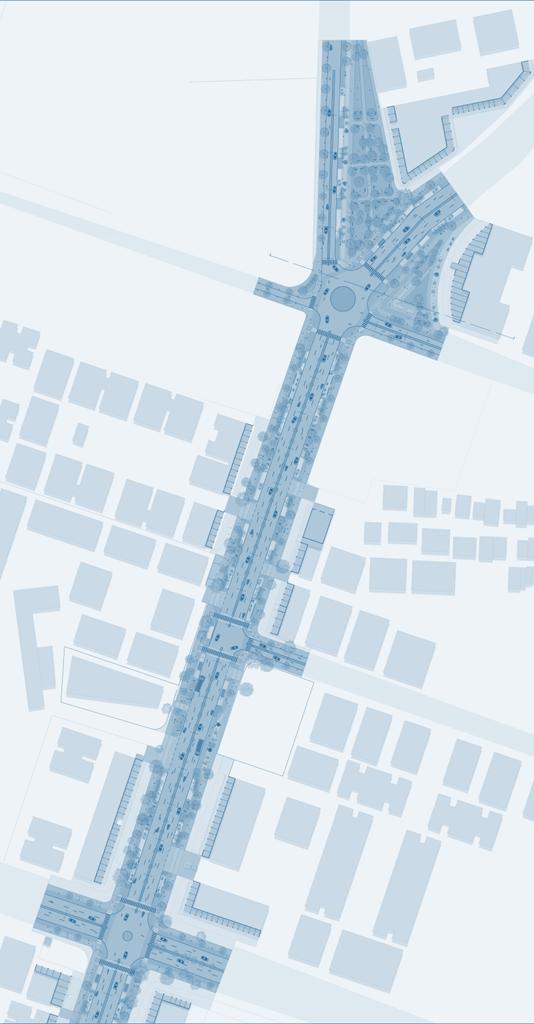
SITE : NEW S.G. ROAD (VANDEMATRAM ROAD)
ROAD LENGTH : 1.2 KM
ROW : 3O M


STREET ACTIVITIES HAVE NO DESIGNATED SPACE.

The area has its focus on Vandematram street as a new SG road. the street need an approach that could contribute to sustainable urban development. This can include adding green spaces, improving public places, enhancing pedestrian, parking.

UNCOMFORTABLE SEATING WITHOUT SHADEING.

UNORGANIZED PRIVATE VEHICAL PARKING AND AUTO RICKSHAW PARKING.
NOT UTILIZING SPACES UNDER EXISTING TREE PROPERLY.


Create pedestrian friendly areas alongside the road and lessen the dominance of private vehicles.
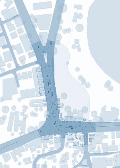
MASTER PLAN

Build an overall pedestrian connectivity among all public areas on the street side.

Establish an edge connection between the street and existing public areas.

Establish a crossing that is accessible and safe.

RECLAIMING PUBLIC SPACE
creating lively public areas next to the road that interact to the building edges.

PEDESTRIANISATION - WALKABLE FRIENDLY STREET Continuous Pathways. Shaded Walkway and Seating.

ORGANIZING - STREET ACTIVITIES
Formal Vending. Pause Points - Active edges.

USERS SAFETY Proper Junction. Raised Pedestrian. Discourage Parking.

18M CARRIAGE WAY

UNPAVED 4 TO 5 M FOOTPATH ON BOTH SIDE


UNPAVED 4 TO 5 M FOOTPATH ON BOTH SIDE

UNPAVED 4 TO 5 M FOOTPATH ON BOTH SIDE

SEATING SPACE
PARKING AUTO RIKSHOW STAND BUS STOP
2.5 M WIDE WALK WAY
2 M WIDE SEPERATE CYCLE TRACK
VENDING ZONE


PERFORMANCE PLAZA


SEATING AREA PARKING
VENDING ZONE CYCLE STAND


FOOD, 23 CLOTH, 09 OTHERS, 17 ON VEHICLE, 18 VEGETABLES, 14

AUTO RICKSHAW, 32 CARS, 70 TWO WHEELER, 340
AUTO RICKSHAW, 40 CARS, 140 TWO WHEELER, 430

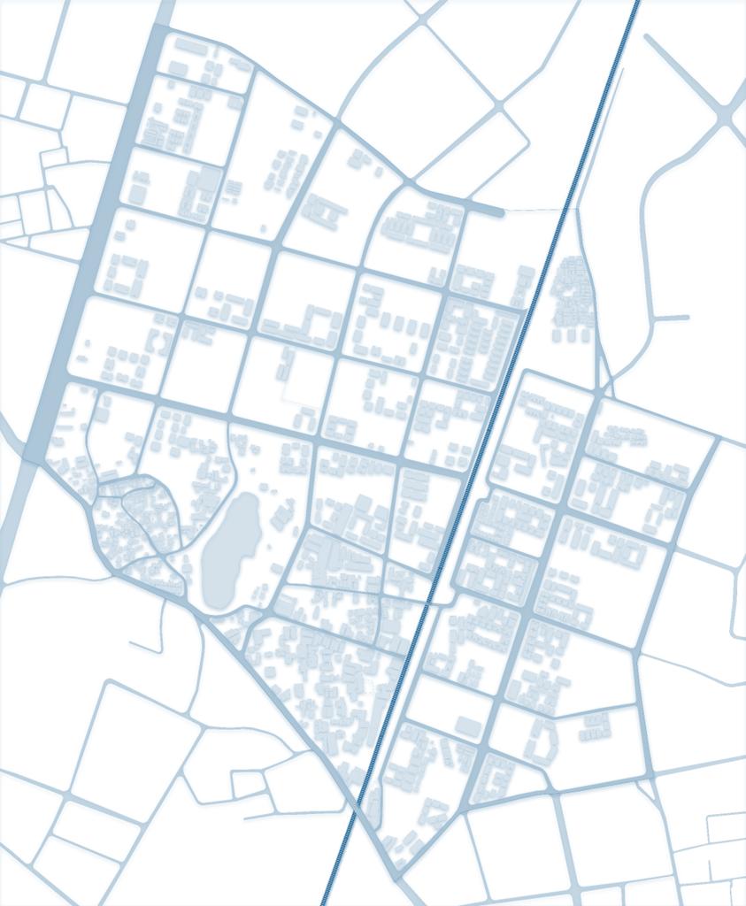
NARODA GAM JUNCTION, NARODA, AHMEDABAD
The city is rapidly growing and the development percolating towards the North-eastern area. The proposed site is located on the North eastern fringe of Ahmedabad city. The proposed site has robust connectivity between the cities of Ahmedabad and Gandhinagar through the national highway 48. Furthermore, the available connection to the S.P ring road strengthen the site’s connection to major landmarks of the city. The site is situated 7.1km from the airport and 1.1km from the Naroda railway station. Transit facilities like AMTS and MRTS at the close proximity makes public transit and commute to the work easy. The proposed road network, industrial estate and growth centers provides immense opportunity for the site.


Social Influence
Existing Gamtals creates opportunities for employment and religious landmarks encourages and act as a magnet for attracting people towards the site.
Economical Influence
Various Commercial, Industrial and Institutional development in close proximity will create high demand for residences in the future.
Ecological Influence
Canal and Karia lake within site potential to develop as public space.


AMTS ROUTE AMTS STOPS MYBYK STOP
BRTS ROUTE BRTS STOP


The vendors are taking over the place and good street furniture and fountains are getting neglected.
The chaos of sellers, customers, and vehicles makes the place chaotic.
Vehicles dominate the public space causing noise and air pollution.


The streets section makes difficult for pedestrians as there’s no pavements or zebra crossing or no separate vehicular lanes.
The density of parking throughout the day and its variation with time, the peak traffic hours affecting the parking layout and makes difficult for pedestrians.


The vendors are taking over the place and good street furniture and fountains are getting neglected. Considering street vendors have a designate space.


The streets has no pedestrians as there’s no pavements or zebra crossing or no separate vehicular lanes. So designing a street section accordingly.


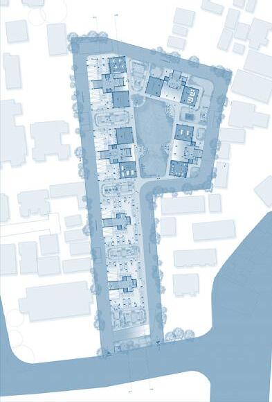
LAKEVIEW APARTMENTS, VASTRAPUR, AHMEDABAD
The project is based on the development of housing project for the city of Ahmedabad in the state of Gujarat. To analyze and propose a viable redevelopment project including planning and with identifying the development in the city, based on variation in terms of location, accessibility, F.S.I. permissible, and various other characteristics.

SITE INTRODUCTION
LAKEVIEW APARTMENTS, VASTRAPUR.
Built year: Around 1990 (32 years)
Total number of building blocks: 27 (G+2)
No. of units: 204 (84 -2bhk, 120 -3bhk)
The Apartments is very old private public housing complex with Around 800 people residents.
SITE CONNECTIVITY AND ACCESSIBILITY
The proposed site is connected by a 18m road providing good connectivity throughout the city.
The major transport network including


