Iowa Floodplain Mapping Complete Easy-to-access, science-based information is one of the best tools we have to protect ourselves from flooding. Working with the Iowa Department of Natural Resources (IDNR), the Iowa Flood Center team recently completed a six-year project to develop updated floodplain maps for the 85 Iowa counties that were declared Presidential Disaster Areas after the 2008 Iowa floods. The U.S. Army Corps of Engineers mapped the remaining 14 Iowa counties.
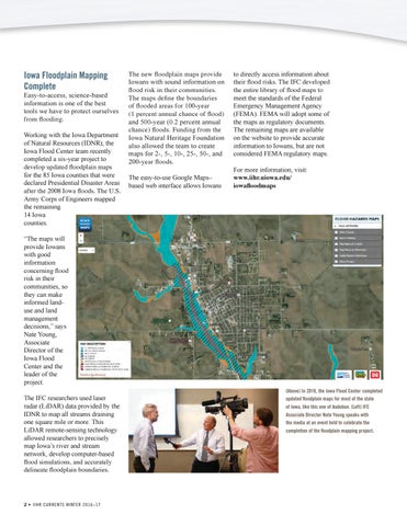
The new floodplain maps provide Iowans with sound information on flood risk in their communities. The maps define the boundaries of flooded areas for 100-year (1 percent annual chance of flood) and 500-year (0.2 percent annual chance) floods. Funding from the Iowa Natural Heritage Foundation also allowed the team to create maps for 2-, 5-, 10-, 25-, 50-, and 200-year floods. The easy-to-use Google Maps– based web interface allows Iowans
to directly access information about their flood risks. The IFC developed the entire library of flood maps to meet the standards of the Federal Emergency Management Agency (FEMA). FEMA will adopt some of the maps as regulatory documents. The remaining maps are available on the website to provide accurate information to Iowans, but are not considered FEMA regulatory maps. For more information, visit: www.iihr.uiowa.edu/ iowafloodmaps
“The maps will provide Iowans with good information concerning flood risk in their communities, so they can make informed landuse and land management decisions,” says Nate Young, Associate Director of the Iowa Flood Center and the leader of the project. The IFC researchers used laser radar (LiDAR) data provided by the IDNR to map all streams draining one square mile or more. This LiDAR remote-sensing technology allowed researchers to precisely map Iowa’s river and stream network, develop computer-based flood simulations, and accurately delineate floodplain boundaries.
2 • IIH R C urre nt s W int e r 2 016–17
(Above) In 2016, the Iowa Flood Center completed updated floodplain maps for most of the state of Iowa, like this one of Audubon. (Left) IFC Associate Director Nate Young speaks with the media at an event held to celebrate the completion of the floodplain mapping project.