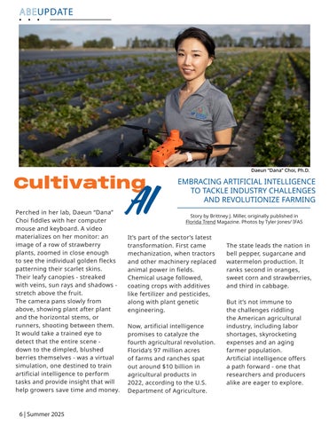

CultivatingAI
Perched in her lab, Daeun “Dana” Choi fiddles with her computer mouse and keyboard. A video materializes on her monitor: an image of a row of strawberry plants, zoomed in close enough to see the individual golden flecks patterning their scarlet skins. Their leafy canopies - streaked with veins, sun rays and shadowsstretch above the fruit. The camera pans slowly from above, showing plant after plant and the horizontal stems, or runners, shooting between them. It would take a trained eye to detect that the entire scenedown to the dimpled, blushed berries themselves - was a virtual simulation, one destined to train artificial intelligence to perform tasks and provide insight that will help growers save time and money.
EMBRACING ARTIFICIAL INTELLIGENCE TO TACKLE INDUSTRY CHALLENGES AND REVOLUTIONIZE FARMING
It’s part of the sector’s latest transformation. First came mechanization, when tractors and other machinery replaced animal power in fields. Chemical usage followed, coating crops with additives like fertilizer and pesticides, along with plant genetic engineering.
Now, artificial intelligence promises to catalyze the fourth agricultural revolution. Florida’s 97 million acres of farms and ranches spat out around $10 billion in agricultural products in 2022, according to the U.S. Department of Agriculture.
The state leads the nation in bell pepper, sugarcane and watermelon production. It ranks second in oranges, sweet corn and strawberries, and third in cabbage.
But it’s not immune to the challenges riddling the American agricultural industry, including labor shortages, skyrocketing expenses and an aging farmer population. Artificial intelligence offers a path forward - one that researchers and producers alike are eager to explore.
Story by Brittney J. Miller, originally published in Florida Trend Magazine. Photos by Tyler Jones/ IFAS
Daeun “Dana” Choi, Ph.D.
Where Science StoryMeets
HYDROLOGICAL MODELING AND THE BLACKFEET NATION
ABE’s Rio Bonham specializes in hydrological modeling; if you asked him to give an elevator pitch of his work he might say something along the lines of, ‘I use computers to predict where water is going to be’. However, inarguably, the most special feature of his work involves a uniquely human element.
Bonham, a second year Ph.D. student under the direction of Drs. Medeiros and Muñoz-Carpena, participates in a research project in collaboration with the Blackfeet Nation, Amskapi Pikuni, in northern Montana. His project, initially funded by the UF ROSF (Research Opportunity Seed Fund) combines Traditional Ecological Knowledge of the landscape into quantitative flash flood models, exploring an intersection between Western science and engineering with

Indigenous knowledge systems. To accomplish his goal of providing a robust and useful model of the patterns and predictions of flooding on the Blackfeet Nation, Rio relies not only on computer models and artificial intelligence (AI), but the rich storytelling history of the Blackfeet people.
His approach addresses aspects that computer models typically miss, like impacts on people and their values related to a problem.
“There are people who’ve been living on the landscape for thousands of years and they understand the landscape better than we ever will. They know how the systems respond to extreme weather events and how different indicators show that things are changing over time. So my research is all about, why don’t we go talk to them and learn from them what should go into our models?” he muses.
The Blackfeet reservation in Northern Montana neighbors Glacier National Park and spans an impressive 1.5 million acres of forestland, prairie and 180 bodies of water. The traditional homeland of the Blackfeet covers a much larger expanse north to the Saskatchewan River in Canada to the Yellowstone River to the south. For over 10,000 years its people have lived on and in natural order with the land marked by the ridge of the Rocky Mountains, nicknamed ‘the backbone of the world’.
“Water is life” has become a familiar protest cry for one of our most vital resources. In the Blackfeet Nation that sentiment resonates. Water plays a particularly special spiritual significance to the Tribe, as well as imbuing financial and environmental importance. Not only is this the water that they need to drink to sustain the lives of their people, but water plays a crucial role in their tourism and agriculture industries. Water carries a lot of weight.

With one foot in modeling and data entry, and the other in observation and empirical knowledge, Rio’s work in hydrological modeling combined with the long held tribal history and stories is about creating an AI tool to help the Blackfeet community plan how to prepare for flash flooding events.
“We do hydrological modeling because we want to understand where water is going to be at, at any given point. Understanding where water is going to be is so important. If there’s too much water, in the event of flooding, we need to be able to predict what the magnitude of that flood is going to be. Is this something that’s going to just come over the banks, or is it going to take out the whole town? On the other side of that is droughts, too. If we have all these different indicators pointing towards that it might be a drought one year, we can help people be prepared for that, maybe that looks like buying up more hay for the cattle. Maybe that looks like managing the dams a little bit differently and redistributing the water allocations. You can start to make adjustments. When you talk about resiliency of communities, part of that is just allowing people to be prepared, making sure that they have the best information available so that they can plan ahead,” Rio explains.
Tools like satellite imagery, remote sensing and machine learning can organize data, produce historical info and make predictions about weather and water events, but in places described as ‘data scarce’, including traditional understanding of the landscape is proving to be a vital key to understanding ecological patterns and projecting with some confidence the future of water behavior in times of climate uncertainty. However, given the importance and significance of water to the Blackfeet, you need the right person for the job.

Rio is soft spoken and earnest and his drive for this research is palpable. There is something about his openness, humble nature, and propensity towards a ‘beginner’s mindset’ that makes him a seemingly perfect candidate to undertake this task with careful consideration, this interdisciplinary balance of engineering and social science.
“The Pikuni Tribe has been super welcoming to just invite me in to come alongside them in their work, especially as I’m not a native researcher. That relationship is only growing. This work is a kind of marriage of physical historical data, word of mouth, and legacy history with some hardware and software. Traditional Ecological Knowledge refers to a relational understanding of the landscape, and Indigenous populations already have that. It’s typically held in the format of things like oral histories, stories. That information is so valuable and so rich, especially when it stays on the landscape, because it is specific to that landscape. That’s a big reason that we’re working with the Blackfeet, because they’ve been living on their land for thousands of years. Their creation stories are from there. It’s the history of their land and their understanding of what their grandfathers and those grandfathers knew and passed down. It’s not just an abstract bunch of numbers in a spreadsheet, it’s real,” he says about the privilege of working with the Blackfeet community, “I’m not an expert just because I come from, you know, our one university, right? They have a thorough understanding of their landscape.”
Rio Bonham
RemoteConnections
JASMEET
JUDGE, PH.D.
BUILDS BRIDGES WITH INDIA

At the beginning of the year, ABE’s Jasmeet Judge, Ph.D. was awarded a prestigious Fulbright Kalam-Climate Scholarship to travel to India for five months in collaboration with two prominent Indian Universities to promote and implement cutting-edge research in the field of remote sensing. Her experience abroad embodied the spirit of the Fulbright Program, the ethos of cultural education, cultural exchange, and cultural literacy. The trip also highlighted the synergy of Judge’s impressive intellectual acumen, sense of adventure and enthusiasm- and a tiny pinch of good timing and good luck.
The primary motivation for the trip was to collaborate with Indian researchers in utilizing satellite data for timely agricultural information for water management, crop assessment, and to train the next generation of Indian scientists in microwave remote sensing. The five-month program allowed her to make connections with Indian Institute of Science (IISc) in south India (Bengaluru) and Indian Institute of Technology in New Delhi (IIT-Delhi), to collaborate on a novel satellite project that will utilize new microwave technology to provide global soil moisture data.
The length of stay for Judge was critical to her ability to integrate and establish relationships with the farmers and engineers there, “I think five months was perfect because you have that sort of ‘honeymoon’ time where you’re just meeting new people and there’s no reflection on what you were doing. After a few months you feel like OK, I’m here, I’m in this routine, these people know me, I’m integrated. Then you can start to get some work done at a deeper level and make long-term plans.”
In Summer 2025, a new satellite mission, the NASA-Indian Space Research Organization (ISRO) Synthetic Aperture Radar (NISAR), will launch, providing microwave data that can be used for generating soil moisture, crop biomass and stress products.
Combined with available data from optical, infrared, and existing microwave sensors, NISAR data can help fill the gap in obtaining high-resolution global soil moisture and crop biomass/stress products every 2-3 days for farmers and water managers.
“If I can combine the data sets with domain knowledge, then we can get data at higher resolution. My interest and goal is to develop data fusion and AI algorithms to combine different data sets and models to improve spatial and temporal resolution,” Judge said.
Judge, who also directs the UF/IFAS Center for Remote Sensing, brings three decades of experience in researching microwave remote sensing, supported by NASA awards. The main goal of her research is to understand how water interacts with soil and vegetation by using both remote sensing and computer models, such as hydrologic and crop growth models. “Soil moisture information is important for understanding crop growth, for irrigation scheduling, and for understanding hydrological balance. This information can shape policy and decision-making perspectives both at farm and national level.”
“Traditional optical satellite imagery can be tricky as the waves that are used to collect data can be blocked by clouds,” Judge explains, “Microwave remote sensing is highly sensitive to changes in soil moisture and makes it possible to bridge the gap between small-scale studies at the field level and larger-scale studies at the regional and global scales. Also, microwaves can penetrate vegetation and give a more accurate picture of soil moisture than other wavelengths.”
“NISAR will have a global moisture product every 6 to 8 days. We have a site in Florida that is a calibration and validation site for the product, and we’re working with the NISAR science team on that. So, when I wrote the Fulbright it was to establish a similar site in south India to see how we can improve the product for agriculture regions in India,” she explained.
Getting accurate soil moisture information for heterogeneous farmlands and farming practices in India can be challenging.

interspersed amongst fields bursting with vegetation.

Farmers will often plant crops using companion planting strategies, watering schedules can be erratic depending upon the availability of electricity, and swaths of fallow land may be
“In India, one pixel, viewed by the satellite, might have intermingled crops- banana, turmeric, ginger, sunflower, garlic- they have 6-8 crops, and one part could be irrigated, and one could be not irrigated; it’s very heterogenous. Also, they water according to their electricity and water availability. With NISAR, you get one soil moisture value per pixel,” Judge emphasizes. To address this, during NISAR overpasses, there has to be some on-the-ground data collection to compare and improve the satellite product. Judge continues, “It can be challenging to really understand the product at a sub-pixel level. We’re expecting to understand it by combining the heterogenous information about what’s happening on the ground with what NISAR will actually see.”
Judge’s Fulbright also had a teaching component. The specific objectives were to discover existing gaps in remote sensing training of the students at IISc and to understand remote sensing skills needed for the research projects conducted at their Interdisciplinary Center for Water Research (ICWaR), and to develop and co-teach a 4-week intensive course in Microwave Remote Sensing in Hydrology. Judge developed the 4-week course for advanced PhD students and early career researchers at IISc.
“I want to design an experiment for the agricultural area where there is ongoing strong collaborations with the farmers, and see what their management routines are, especially on the day NISAR flies overhead. On the day of the overpass, we want to know what has happened in the field. Currently, students are not trained to do this sort of sampling and data collection, I will continue to work with them even when I am back in the US,” she professed.
Remarkably, fortune favors the brilliant, and while on her Fulbright tenure, Judge discovered that she had secured another fellowship, VAIshwik BHArtiya Vaigyanik (VAIBHAV), through the Ministry of Science and Technology, Government of India, which will allow her to further enhance the research and collaborations she initiated on her five-month Fulbright trip.
“I got the Fulbright, and then when I was there, in February, I found out we also got the VAIBHAV which will sponsor my return to India to continue this research and uphold these collaborations. So now I have a long-term relationship for three years and in that time frame, I will go to India for two months every year,” Judge said, “If I get to do it again, I wouldn’t change a single thing. Mentoring those students and working with the faculty was really fun, and we created enduring connections to move this research forward.”
Jasmeet Judge, Ph.D.
Weather or Not: Climate Resilience for the Future
From the early days of Almanacs, word of mouth and written journals to the sophisticated systems used today, the need to understand and predict the weather has been a cornerstone of civilization. In an era marked by anomalous weather patterns and more frequent extreme events, the importance of robust modeling tools is more significant than ever.
ABE’s Nasser Najibi, Ph.D., an Assistant Professor of Climate Resilience and an Extension Specialist, aims to make unprecedented weather patterns more predictable. His research interests focus on developing engineering approaches, decision support tools and data sets at the intersection of hydroclimate extremes, risk assessments and systems planning in a changing environment.
The way he describes his work is reminiscent of a teacher layering transparencies on an overhead projector, overlapping images to reveal areas of connected information.
“My research and extension programs are composed of three primary thrusts. The first is process understanding of past hydroclimate extremes such as floods, droughts, heatwaves, and extreme precipitation events.
Second, understanding the impacts of changing climate and weather systems on future climate extremes. And third, advancing water resource systems planning and climate adaptation in a changing environment,” Najibi said.
Najibi’s professional trajectory has primed him to be an ideal asset in the current study of weather events and their impacts in Florida. His experience as a Research Associate and Postdoc at Cornell, an ORISE Fellow with the Department of Defense, and collaborative research with the California Department of Water Resources and Massachusetts Executive Office of Energy and Environmental Affairs combine to make him, well, the perfect storm for understanding weather.

ABE’S NASSER NAJIBI, PH.D. TAKES A MASTERFUL APPROACH TO UNDERSTANING WEATHER SYSTEMS

Nasser Najibi, Ph.D.
California- a hotbed of extreme weather variability, can experience wildfires stemming from drought, mudslides from heavy precipitation; indeed, the pendulum can swing as far as the state’s topography, from balmy beach to snowy mountaintop. In his work with the California Department of Water Resources, Najibi contributed to the development of a statewide stochastic weather generation model used to build a decision tool able to explore different plausible future precipitation and temperature scenarios; and, fortunately, he aims to bring this strategic research to Florida.
“Florida is a very interesting setting in general. We have any sort of extreme weather events that you can imagine. There are flash floods, back-to-back long-duration flood events, widespread extreme precipitation events, severe hurricanes, dry seasons and heatwaves, right? And we have another factor which is population growth. It’s

a fairly complex system and we have to study what’s going on in multiple locations what can happen when natural systems are pushed out by urban expansion,” he continues, “Most of those tools that we developed for other parts of the country are such that they can be also calibrated for this area, but we have to modify most of the components in order to be reflective of this area. I’m developing climate-informed frameworks, data sets and impact-based tools in general to support climate vulnerability assessments across different sectors and scales here,” he said.
The ability to quantify the magnitude of a storm can inform a region’s strategic response. In emergency situations that may involve decisions such as evacuating an area ahead of a major weather event, in the long term that may look like implementing infrastructural changes to mitigate the impacts of flooding, such as building bridges or refining municipal drainage. Variables such as air temperature, rainfall, infrastructure and topography are considered when making predictions for future weather events.
“Whether precipitation will translate to flooding depends on whether you have infrastructure on the ground that they will either amplify or mitigate impacts of heavy precipitation events. Flooding is a little complicated in this sense because it’s not only coming from the atmosphere. There are the watersheds that are holding water, there is the presence of groundwater. There’s the human impact and anthropogenic transformation in that landscape that that has amplified the impacts of flooding,” Najibi said.
As temperatures rise and stay hotter, our atmosphere retains more water, contributing to more severe precipitation events. Another factor is atmospheric rivers, giant rivers in the sky made of dense accumulations of water molecules like tropical storms that flow in a plume, some capable of holding as much water volume as the Amazon. They give us much of the rain needed to fill rivers and lakes, or recharge groundwaters. But they can also cause big problems. We are at risk from floods, damage to roads and homes and businesses, sewer overflows, and even landslides or sinkholes if there’s too much rain too fast.
“Precipitation is scaling with temperature. From an atmospheric science point of view, we can say that if you warm up the atmosphere, the atmosphere will hold more moisture which correlates to a higher chance of getting more of those kinds of intensified extreme precipitation events. This is demonstrated in the literature and there are physical theories behind this. If you warm the atmosphere up by one degree Celsius, there will be around 7% increase in extreme precipitation, although this rate may differ and remain uncertain across different rainfall-generating mechanisms and geographical settings,” Najibi explains.
Najibi’s work is a sophisticated multidisciplinary amalgamation of statistics, engineering, and modeling which approaches short-term to long-term planning for critical infrastructure systems, his experience in processed-based models, statistical learning and data driven models allow research involving many variables and unknowns and compound events, such as flooding in many different regions at once. Coupled with a Ph.D. in Civil Engineering, he is poised to not only understand the data but also formulate plans with his findings.
“Over the next 10 years, 50 years, you want to see how your system will behave against our warming atmosphere. I study these things in an effort to quantify their drivers, their impacts. Looking at critical infrastructure systems in particular, water resource systems, dams and energy systems are all areas I’ve been working on. But you can expand to other systems like agriculture and public health systems, infrastructures like transportation systems, cybersecurity systems, defense and military; all of these kinds of systems can be exposed to the impacts of climate and weather and can cause disruption to our welfare, economy, security, public health, or any combination thereof. Whether they will be impacting Southeast or Northeast, whether they will change in terms of their spatial footprints or temporal, frequency, whether they will happen sooner in the year or later in the year, and all those variables with this can be under the impacts of atmospheric warming,”
Najibi’s lab, the Climate Resilience Lab, is looking into developing risk-based metrics, decision support tools and impact data sets at the intersection of hydro climate extremes, risk assessments and systems planning in a changing environment, “Overall, the overarching goal of my work is to ensure that society is prepared for the impending impacts of climate extremes and can sustain reliable infrastructure systems and safe water use into the future,” he said.
Zen and the art of PFAS Mitigation
From the nonstick Teflon pans that make cooking a breeze to the stain-resistant carpet that keeps our homes looking new, per- and polyfluoroalkyl substances (PFAS) have been heralded as miracle workers in our daily lives.
However, beneath the surface of their seemingly innocuous applications is a more complex story. Studies have found PFAS to be toxic, even at very low concentrations. There are direct correlations between PFAS exposure and adverse impacts to human health, causing increased risks of certain cancers, immune system problems, and reproductive issues.
Further, because of the molecular makeup of PFAS, they are not going anwhere any time soon. They are known as “forever chemicals” and sometimes “ubiquitous chemicals” because of their exceptional lasting power, and their uncanny prevalence all over the world.
“We call them forever chemicals because of their carbon-fluorine makeup. The carbon-fluorine bond is the one of the strongest bonds in nature. They are not broken down by natural systems, resulting in accumulation in the environment. You cannot break them down easily. So once they get into the environment, PFAS can stay stable for days and years and even decades,” said Dengjun Wang, Ph.D., a UF/IFAS assistant professor of agricultural and biological engineering.
Due to their ability to be transported both by air and by rainfall, PFAS have been found in the most remote corners of the globe, even in serum samples taken from polar bears -- in regions that have never seen a non-stick pan or a tube of waterproof mascara.


“The carbon backbone of the PFAS molecule is hydrophobic, and the head group of the molecule is hydrophilic. This is why they can transport through the water and through the air and are so widespread in water and soil, air and almost everywhere,” Wang said.
Wang focused his doctoral research on the transport, transformation, and remediation of PFAS in the environment, specifically the impact of PFAS on water quality and agriculture.
He has a remarkably chipper, inspired and warm personality, especially given the seemingly daunting task of tackling an enduring, omnipresent toxic chemical. Talking to him gives one the feeling that maybe everything is going to be OK. His office is tidy and full of sunshine. There’s a photo of his two cute children next to a computer monitor displaying a closeup of a complex molecule.
ñDengjun Wang, Ph.D.
“My research ties to PFAS and how they move in the environment, specifically soil and water -- and how these chemicals get into plants in agricultural systems. PFAS compounds can be found in water, fertilizers, pesticides, and biosolids. They are drawn up into the plants, and then can be transferred through the food chain,” Wang said.
Through his research, Wang hopes to mitigate adverse effects from these contaminants to our soil, water and plants, eventually to achieve sustainable agriculture.
The approach to mitigating PFAS in agriculture and water safety is manifold. The U.S. EPA has taken steps to prohibit the usage of any new PFAS chemicals--- but the ones that have bioaccumulated still fester.
Perhaps the most profound impact to our health is the pollution of groundwater due to PFAS contamination. The most common pathway for PFAS to our groundwater is through infiltration from aqueous film-forming foam-, -- a supremely efficient firefighting foam, and landfill leachate from garbage dumps, where liquid from PFAS containing products distill and seep into our water supplies.
“In the United States, 60% of the population relies on groundwater as their drinking water source. So, it’s a big problem right now.” Wang said.
So, how to address the PFAS that have already permeated the environment? Microbes cannot break down the chemicals, water, touted “the universal solvent” cannot transform them-
Wang fights poison with fire.
“We utilize agricultural wastes to produce biochar, which is a carbonaceous material with unique physicochemical properties for PFAS remediation,” he said. “We burn agricultural wastes, otherwise they will be dumped somewhere to cause harm to the environment. So, we recycle, collect, put them into the furnace, and burn them, to produce the biochar and utilize the biochar as a sorbent to capture PFAS and purify the drinking water. It’s kind of a circular economy--- we get the dirty stuff, the agricultural wastes, and then produce the good bio char materials and then remove the dirty PFAS compounds from the water.”
In addition to being used in a filter application (sorbent), biochar can be used as an amendment to soil. In his current research, Wang develops superior biochars for PFAS remediation.
“If you have the ring of water containing PFAS, you can dig a trench and fill up with biochar,” he said. Wang describes using biochar in agricultural applications, “so that runoff water can pass through the biochar barrier in the trench, and then the bio char can capture the PFAS along with other contaminants. Then you have the clean water after moving through that barrier. So Iin that case, you can stop the path of the PFAS water from the runoff water to your plants and your crops.”

The PFAS captured by the biochar can then be destroyed. using ultrasonication or other advanced destruction technology. “The beauty of biochar is that it can be recycled and used for multiple cycles to further lower the treatment costs. One of the hurdles with PFAS mitigation is cost of technologies and educating farmers on alternative products and procedures,” Wang said. It’s an uphill battle, and the fight is for global human health. “We have to tackle the problem. It is not an easy problem, it is really challenging. We have to find a solution.” Wang said.
Meet our
ASABEFellow

Charlie Li, Ph.D.
Congratulations to Charlie Li, Professor, for being elected as a Fellow of the American Society of Agricultural and Biological Engineers (ASABE).
Li joined ABE in 2023 with a research focus on developing innovative agricultural artificial intelligence (AI) and automation technologies that ensure an efficient and resilient agri-food chain. His research program aims to advance digital agriculture through innovations in sensing, robotics, and machine learning to address critical challenges such as labor shortages and the growing need for increased agricultural productivity and resilience. His contributions have significantly advanced specialty crop harvesting, postharvest handling, and high-throughput phenotyping for accelerated crop breeding. Li also holds an administrative appointment to lead the UF/IFAS Faculty AI Working Group to promote interdisciplinary collaborations in IFAS.
The ASABE Fellowship is a prestigious recognition of Dr. Li’s exceptional leadership, service, and contributions to the field of agricultural engineering. This honor acknowledges his commitment to advancing the discipline through research, education, and outreach.
