Advanced Professional Planning Studio (University of Calgary)
Daniella Burke, Lucas Campbell, Collin Hnetka
2025-04-22
(Academic Project)
ACKNOWLEDGEMENTS
We extend our sincere thanks to our academic advisors for their guidance, the steering committee for their time and expertise, and our partners for supporting this project.
PROJECT TEAM
Daniella Burke
Lucas Campbell
Collin Hnetka
ACADEMIC ADVISORS
Zach Hoefs, Instructor
Ryan Lebell, Teaching Assistant
STEERING COMMITTEE
Allison Davelaar, CMLC
Maggie Dycke, City of Calgary
Evan Goldstrom, City of Calgary
PARTNERS
City of Calgary
Federation of Calgary Communities
Falconridge/Castleridge Community Association
LAND ACKNOWLEDGEMENT
We acknowledge that the Castleridge, Falconridge, and Westwinds neighbourhoods are developed on the Treaty 7 Indigenous territory of the Blackfoot Confederacy (comprising the Siksika, Kainai, and Piikani Nations), the Tsuut’ina Nation, and the Stoney Nakoda Nations (Chiniki, Bearspaw, and Goodstoney). The community is also home to the Otipemisiwak Métis Government of the Métis Nation within Alberta Districts 5 and 6.
These lands have long sustained the culture, language, and ways of knowing of Indigenous Peoples. We recognize that these communities remain stewards of the land, and we honour their enduring connection to this place.
We are committed to meaningful engagement with Indigenous partners. Their perspectives, histories, and knowledge will be essential in shaping a plan that honours this territory, protects its ecological integrity, and supports respectful access for all.
Many Chief Consulting Ltd.
Equity is recognizing that different communities face different barriers, and responding with support that meets their specific needs.
EXECUTIVE SUMMARY
Like many post-1970s suburban neighbourhoods, Falconridge, Castleridge, and Westwinds are experiencing shifting demographics, aging infrastructure, and increasing demand for housing options that better reflect the needs of the families that live there. With strong transit connections and proximity to employment hubs, these communities are also well positioned to support thoughtful reinvestment.
This report presents a comprehensive planning approach developed by our student team to support the future of Falconridge, Castleridge, and Westwinds. Guided by equity, our recommendations seek to address current challenges while creating more complete, connected, and resilient neighbourhoods.
Each recommendation within this report is supported by policy and designed to guide future investment and growth in a way that respects the identity of the community, while also adapting to changing social, environmental, and economic conditions. The proposed plan is equity-driven, ambitious, and intended to help these northeast communities thrive in the years ahead.
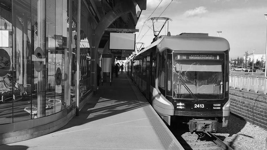
McKnight/Westwinds LRT Station
1.0 BACKGROUND
1.1 Site Context
1.2 Our Team
1.3 Project Introduction
1.4 Project Understanding
1.5 Interested Parties
1.6 Policy Framework
1.7 Methodology
1.8 Project Schedule
1.9 Budget
2.0 ANALYSIS
2.1 Background
2.2 Land Use
2.3 Mobility
2.4 Open Space
2.5 Summary of Analysis
3.0 ENGAGEMENT
3.1 Process
3.2 Community Tour
3.3 Community Workshop
3.4 Business Owners Panel
3.5 Open House
3.6 Summary of What We Heard
4.0 EQUITY
4.1 Vision
4.2 Strategy
4.3 Matrix
4.4 Indicators
5.0 LAND USE RECOMMENDATIONS
5.1 Urban Form and Scale
5.2 Neighbourhood Family
5.3 Community Hubs
5.4 Activity Centres
6.0
MOBILITY POLICY
6.1 Pathways
6.2 Intersection Upgrades
6.3 Pedestrian Crossings
6.4 Utility Corridor
7.0 OPEN SPACE POLICY
7.1 Microforests
7.2 Renaturalization
7.3 Parking Lot Conversion
7.4 Pick a Park Program
8.0 CONCLUSION
8.1 Summary of Interventions
8.2 Final Metrics
8.3 Application
BACKGROUND
CITY OF CALGARY
FALCONRIDGE, CASTLERIDGE, WESTWINDS COMMUNITIES
Site Context
The community is located in the northeast quadrant of the City of Calgary. At the western-most end of the site is the McKnight-Westwinds LRT station which provides transit access to downtown. The MAX Orange BRT travels through the centre of the community providing direct transit access to SAIT, the University of Calgary, and the Foothills Medical Centre.
Within and nearby the community are major employment hubs including the Calgary International Airport, Calgary Police Headquarters and Peter Lougheed Hospital.
To access indoor recreation facilities, residents must travel north to the Genesis YMCA, or south to the Village Square Leisure Centre.
The community is also home to Baitun-Nur, Canada’s largest purpose-built Mosque.
YYC International Airport Calgary Police HQ Peter Lougheed Hospital LRT Station BRT Station
Recreation Centre
Baitun-Nur Mosque
MARTINDALE
BACKGROUND | Our Team
FJELDESIGN is a Calgary-based planning firm specializing in community improvement. Our name is derived from “fjell” the Norwegian word for “mountain.” We are inspired by the strong connection that Calgary has to the Canadian Rockies, similar to the relationship that Nordic cities have with their own nearby landscapes. We aspire to integrate Scandinavian principles within local context, ensuring each project honours Calgary’s identity while meeting the unique needs of the community.
COLLIN HNETKA
Having over a decade of design experience working in both the private and public sectors, he is interested in enhancing the public realm and mobility through research and the integration of natural environments into cities.
DANIELLA BURKE
With ten years of experience in outdoor education, recreation, public service, and engagement, she brings a unique perspective to planning focusing on encouraging community interaction through parks and public amenities.
With experience in both academic and practical planning fields, he brings a passion for sustainable development, dense housing, walkable communities, active and public transportation, and climate change solutions. 1.2
LUCAS CAMPBELL
BACKGROUND | Project Introduction
INTRODUCTION
This project is rooted in the northeast Calgary communities of Westwinds, Castleridge, and Falconridge. These are diverse, established neighbourhoods shaped by decades of growth and evolving demographics. Located near key infrastructure like the Calgary International Airport and regional employment hubs, this community offers both opportunities and challenges tied to mobility, open space, and built form.
Our work focuses on creating a 50-year plan and development strategy that not only reflects community needs, but also responds to the broader challenge of equity. Through detailed analysis, community workshops, and engagement with a variety of stakeholders, we aim to propose strategies that will carry this community forward for the next half-century.
Baitun-Nur Mosque
View of Downtown from Prairie Winds Park
BACKGROUND | Project Understanding 1.4
THE CHALLENGE
Falconridge, Castleridge, and Westwinds are neighbourhoods that have experienced unique growth in Calgary due to constraints being located in the Airport Vicinity Protection Area. While Falconridge and Castleridge have developed into quaint residential neighbourhoods, it is contrasted by Westwinds’ industrial feel, with very auto-oriented uses. Since their establishment in the early 1980’s these neighbourhoods have seen significant demographic change, and are now facing complex challenges related to housing, safety, infrastructure, and accessibility. The findings in this report are key to preparing the community for the changes in the coming decades.
This community provides many opportunities that support this project. It is home to a rich diversity of people and cultures, and has a strong access to transit despite its location in suburban Calgary. However, there are also challenges that must be considered. Community members cite safety, traffic, and accessibility issues, as well as aging infrastructure and unsuitable living conditions. There is also a major disconnect between the residential neighbourhoods and Westwinds. This report summarizes how we will address these opportunities and challenges to guide the community to a more resilient and connected future.
As an academic project, this report supports the communities of Falconridge, Castleridge, and Westwinds with a series of land use, mobility, and open space recommendations. These are intended to serve as a guide that reflects both the lived experience of residents and the long-term aspirations of a growing city.
View of Westwinds from Prairie Winds Park
BACKGROUND |
Interested Parties
Local Schools (Bishop McNally High School)
Real Estate Developers (Carlisle Group)
School Children
Falconridge Castleridge Community Association
Seniors and Residents with Disabilities
Local Businesses
(Terry Fox Jr. High School)
Federation of Calgary Communities
Local Places of Worship (Baitun-Nur Mosque)
Diverse Residents
Local Businesses (Kabob Garden)
City of Calgary
Employers
(Calgary Police Service Headquarters)
BACKGROUND |
Policy Framework 1.6
The project team used the following statutory and non-statutory planning framework to guide the development of this plan. The community does not currently have an Area Structure Plan, Area Redevelopment Plan, or Local Area Plan.
Municipal Development Plan
A statutory plan that guides Calgary’s growth and sets the direction for future land use, mobility, servicing, and investment decisions to prepare for the next 30 years. We must align with the policies outlined in the plan.
Calgary Transportation Plan
A statutory plan that provides direction for how Calgary delivers transportation options for the next 60 years. It is closely integrated with the Municipal Development Plan. It is necessary to follow the policies outlined in the plan.
Regional Growth Plan
A statutory plan providing a framework for how the Calgary Metropolitan Region manages growth and development. Its focus is on regional collaboration over the next 30 years. It is required to align with the policies outlined in the plan.
Guide for Local Area Planning
A non-statutory plan guiding the development of new Local Area Plans. It establishes a consistent approach to creating plans that reflect Calgary’s citywide goals. Using these guidelines will help us be consistent with the LAP’s.
TOD Policy Guidelines
A non-statutory plan that provides a framework for planning and designing mixed-use, pedestrian-friendly, and higher-density developments near transit stations. These guidelines will help us plan adjacent to the LRT station.
Connect: Calgary’s Parks Plan
A draft non-statutory plan that provides a thoughtful update to Calgary’s 22-year old Open Space Plan. This plan provides guidelines for the management of the Parks system. We will consider these strategies in planning greenspaces.
BACKGROUND | Methodology
This project followed an approach similar to that of the City of Calgary’s Local Area Planning. Here you will find our detailed work program that was developed specifically for this project and its shorter time frame. This methodology outlines our approach and tasks, as well as key dates.
The project was broken into five phases:
Phase 1 - DISCOVER (Research and Awareness)
Phase 2 - ENVISION (Analysis and Visioning)
Phase 3 - EXPLORE (Conceptualization and Engagement)
Phase 4 - REFINE (Feedback and Finalization)
Phase 5 - REALIZE (Application and Monitoring)
Throughout the project, we actively engaged with the community to ensure their concerns were addressed. We also received feedback from the Steering Committee and our Instructors.
BACKGROUND |
Methodology
PHASE 1
JAN 13 - JAN 21
DISCOVER
DISCOVER begins at the initiation of the project. It involves pre-project research to determine the scope of the project, as well as building awareness of the community, its challenges, and its opportunities. It ends with a finalized proposal and includes:
1. Project Initiation (Jan 13)
We will initiate the project with a meeting to discuss the scope of the project, tasks, and schedule.
2. Community Tour (Jan 16)
The project team will meet at the Community Centre with FCCA President Druv Sharma, and General Manager Lee Pederson. There we will discuss the pressing challenges and opportunities.
3. Data Library and Base Mapping
We will begin building a data library and developing base maps with location, land use, transit, and open space information.
4. Legal Framework Review
Legal framework will be reviewed to ensure compliance with local and regional policies.
5. Finalize Proposal (Jan 21)
We will finalize the proposal and submit it for review.
PHASE 2
JAN 22 - FEB 6
ENVISION is about delving deeper into the past and present state of the community to determine their needs and assess what is possible. This is achieved through comprehensive analysis, which will help us establish priorities to shape their vision for the future.
1. Neighbourhood/Site Analysis
The team will conduct various neighbourhood analyses including: historical, environmental, climate and weather, land use, infrastructure (traffic, utilities, facilities), housing and building typology, greenspace, pathway connections.
2. Community Profile
We will develop a comprehensive community profile that will give us a better idea of what the community might need.
3. Steering Committee Presentation (Feb 6)
This will be the first presentation to the Steering Committee, where we will present the findings from our analysis.
4. Community Workshop (Feb 6)
This phase ends with a community workshop where we will provide an opportunity for the public to help define the project through discussion and mapping.
BACKGROUND |
PHASE 3
FEB 7 - MAR 14
EXPLORE Methodology
EXPLORE is the longest phase and is a discussion of determining where and how change can occur within the community. This involves a cycle of conceptual design drafting and feedback.
1. Workshop Review
We will first review the results from the community workshop, and summarize what we heard. From these results we will further be able to prioritize the needs of the community.
2. Community Mapping
Using the community mapping exercise from the workshop, we will identify specific locations within the community that require the most intervention based on a SWOT analysis.
3. Concept Design Drafting
Building on community feedback and mapping, we will propose draft design interventions considering land use and growth, housing, commercial use, large parcels, transportation, and open space and pathways.
4. Steering Committee Presentation (Mar 14)
The final stage of this phase is a presentation to the Steering Committee of the Draft Design, including our analysis, public engagement, and recommended interventions.
PHASE 4
MAR 15 - APR 15
REFINE is where we review all feedback from the Steering Committee and revise the Concept Design. We will ensure the concept aligns with the priorities set out in the previous phases. At the end of this phase we will present a final design to the community and Steering Committee for final feedback.
1. Concept Design Revisions
The first part of this phase is to review the conceptual design based on feedback from the Steering Committee. We will draft a final Concept Design to present to the community and Steering Committee for any final feedback.
2. Community Open House (Apr 12)
We will host a public open house to provide an opportunity for the public to learn about the project and provide feedback. We will hold the open house in person, so community members can interact with us and our designs.
3. Steering Committee Presentation (Apr 15)
We will integrate final feedback from the Open House and present the final design to the Steering Committee. This will be the final meeting with the Steering Committee before the final concept and report deadline.
BACKGROUND |
REALIZE Methodology
REALIZE is the final phase of the project. It consists of integrating feedback from the community and Steering Committee to finalize and submit the Design Concept for Council review. This phase will be ongoing as it also includes implementation and monitoring.
1. Concept Design Finalization
We will first finalize the Concept Design considering all additional feedback received during the Community Open House and final presentation with the Steering Committee.
2. Final Report and Poster Submission (Apr 22)
The project team will be responsible for the production of the final report. The final report will include, at minimum: an Executive Summary; Introduction; Site and Context Analysis; Summary of Public Engagement; Concepts, Strategies, and Guidelines; and Policy Recommendations.
3. Implementation and Monitoring
Providing the final concept design is approved by the steering community, the team will follow all required steps towards implementation including presentation to Council. Following Council approval, the project team will ensure the successful implementation of the design through careful monitoring.
Project Schedule
ANALYSIS
ANALYSIS | Background
EARLY HISTORY
Indigenous people live on and use the land for over 10,000 years
1961 Land Annexed from Rocky View County to Calgary 1979 Falconridge Established Expands Station Opens
The community is reaching the end of its lifecycle Max Orange BRT Service Begins
The history of this site begins with the Indigenous peoples including the peoples of Treaty 7, including the Blackfoot Confederacy, the Tsuut’ina, the Stoney
In the 1960s, the land that eventually becomes this community is annexed by the City of Calgary from Rocky View County. In the late 1970s and early 1980s, the neighbourhoods of Falconridge and
began to be constructed. In the 40+ years since then, we’ve seen the growth of the Industrial and Commercial neighbourhood of Westwinds, the consrtuction of the Calgary Police headquarters, and the investment of the
Nakoda Nations.
Castleridge
LRT and BRT networks.
ANALYSIS | Background
URBAN MORPHOLOGY
Originally a wetland ecosystem, the very first homes were built in 1979 which followed with rapid residential construction over the next 5 years. The community began to look like what it is now in 2008 with the completion of the LRT station and the associated Blue Line.
ANALYSIS | Background
DEMOGRAPHICS
ANALYSIS | Background
ANALYSIS | Background
FALCONRIDGEBLVD.NE
SchoolChildcare
YYC_ShoppingCentr
ANALYSIS | Land Use
ANALYSIS | Land Use
HOUSING TYPOLOGY
Castleridge
ANALYSIS | Land Use
ANALYSIS | Land Use
BUILDING AGE
FALCONRIDGEBLVD.NE
ANALYSIS | Land Use
FALCONRIDGEBLVD.NE
Part of the site falls within the Airport Vicinity Protection Area, which imposes specific land use restrictions. In these areas, residential uses, schools, and medical care facilities are prohibited. These limitations will influence how future development can occur in Westwinds, though they do not apply to Castleridge or Falconridge.
ANALYSIS | Land Use
FALCONRIDGEBLVD.NE
ANALYSIS | Land Use
FALCONRIDGEBLVD.NE CASTLERIDGEBLVD.NE
Residential parcels in the community are shaped by the road network. While many lots are small and rectangular, a number of mid-sized parcels have irregular shapes due to their location within cul-de-sacs. This influences the type and scale of development that can occur on these sites.
FALCONRIDGEBLVD.NE
CASTLERIDGEBLVD.NE
Metis Trail and McKnight Blvd act as major barriers for the overall community. Combined with the arterial roads of 64th Avenue and 68 Street the community is effectively cut off from its surrounding neighbours. Falconridge Blvd is another arterial road which acts as a divider between the East and West. Collector and arterial roads can act as guides for future development and changes. Most residential roads only have a sidewalk on one
and are
ANALYSIS | Mobility
CASTLERIDGEBLVD.NE
The surrounding roadways of the community have high-speed limits, which contribute to pedestrian/vehicle collisions, a sense of disconnection, and create low-quality spaces for pedestrians.
ANALYSIS | Mobility
ANALYSIS | Mobility
Here we can see a 1200m walkshed from the LRT which is lacking in terms of coverage in the residential area. The 800m walkshed for the BRT has great coverage throughout.
ANALYSIS | Mobility
ANALYSIS | Mobility
FALCONRIDGEBLVD.NE
CASTLERIDGEBLVD.NE
The current pathway network only covers a small portion of the community, however the planned 5A network has the potential to serve more people once finalized.
ANALYSIS | Mobility
FREQUENTLY TRAVELED ROUTES
the
FALCONRIDGEBLVD.NE CASTLERIDGEBLVD.NE
ANALYSIS | Mobility
PEDESTRIAN TRAFFIC INCIDENTS
FALCONRIDGEBLVD.NE
ANALYSIS | Open Space
OPEN SPACE TYPOLOGY
CASTLERIDGEBLVD.NE
FALCONRIDGEBLVD.NE
Open Space
ELEVATION AND SLOPE
ANALYSIS | Open Space
TREE CANOPY
OwnershipParcelFa
Tree Coverage 8% 11% Calgary Calgary Climate Strategy Goal 16%
The community’s overall tree canopy is at 8% coverage. This is below the city’s current coverage of 11%. The City of Calgary’s Climate Strategy has set a goal to increase the city’s average tree canopy to 16%. To be more equitable, our under-served community should be receiving a lot more trees. The community contains twelve different tree types, representing a moderate to high level of diversity compared to other Calgary neighbourhoods. This level of biodiversity enhances the urban forest’s resilience to pests and diseases.
ANALYSIS | Open Space
FALCONRIDGEBLVD.NE
In Calgary, approximately 33% of land is impervious, while our site has a much higher rate at 55% impervious surface coverage. This elevated level is largely due to expansive parking lots and large building footprints that make up Westwinds. Impermeable surfaces like asphalt contribute
ANALYSIS | Open Space
ANALYSIS | Summary of Analysis
Poor Equity Score
Vehicle-Oriented Streets Impact Pedestrian Safety
Strong Prevalence of Multigenerational Families
Residential - Commercial Disconnect
Good Public Transit Access
Low Tree Canopy
ENGAGEMENT
What we heard from the community.
ENGAGEMENT |
DISCOVER ENVISION EXPLORE REFINE
At the initiation of the project, we met with Community Association President Druv Sharma and General Manager Lee Pederson for a tour of the community and to gain a sense of what the priorities of the Community Association are for the project.
On January 30th, we met with business owners and employees online to learn about their experiences working and owning a business in the community.
On February 6th, we held a community workshop at the Falconridge/ Castleridge Community Association, where we gained valuable feedback on our analysis of the community to guide our concept design.
On April 12th, after developing our concepts, we brought them to the community at a public open house where we received feedback about our proposed interventions.
ENGAGEMENT | 3.2
Community Tour
WHAT WE DID
At the start of the project, we visited the Castleridge/Falconridge Community Centre for a tour and our first opportunity to speak directly with residents. Longtime community members Druv Sharma and Lee Pederson from the community association shared their reflections on how the neighbourhood has evolved. Druv, who grew up in the area, described a noticeable rise in rental properties, crime, and social disorder over the past decade. He expressed concern about safety for children, particularly around Prairie Winds Park and the Westwinds LRT station, and emphasized the need to “revive” the community with beautification efforts like murals and safer public spaces.
WHAT WE HEARD
Lee discussed challenges with accessibility (especially from the perspective of his son who uses a wheelchair), aging infrastructure, and a lack of winter maintenance. Issues make it difficult for families and seniors alike. Both voiced frustration with underutilized parks, inadequate city support, and the pressures of densification, particularly a proposed 400-unit development near the LRT station. While they support community growth in principle, they stressed that the scale and location of new developments must reflect the neighbourhood’s capacity and needs.
Community input highlighted to us the importance of thoughtful, locally informed planning that builds trust and improves quality of life for existing residents.
Mural at the Falconridge/Castleridge Community Centre, by @rachellyondesignco
Potential park space at the cul-de-sac at Falworth Ct. NE
ENGAGEMENT | 3.3
Community Workshop
WHAT WE DID
WHAT WE HEARD
On Thursday, February 6th, we presented a summary of the analysis we had done far at a community workshop held at the Castleridge/Falconridge Community Centre. Despite a low community turnout, the event provided valuable experience presenting our preliminary ideas to both peers and a few engaged residents and planning professionals. It gave us a chance to test how effectively our concepts translated to a public audience and to refine the way we communicate planning concepts in accessible ways.
Throughout this process, we gained a cleared understanding of the kinds of concerns and priorities that matter most to the community including safety, walkability, housing options, and access to green spaces. Even limited feedback helped us identify gaps in our proposals and highlighted the importance of designing with—not just for—the community.
This early engagement confirmed for us how an approach from an equity-driven planning perspective was clearly the pathway to take.
Rowhouse type housing on Falconridge Cres. NE
Us with a board at the community workshop
ENGAGEMENT | 3.4 Business Owners Panel
WHAT WE DID
We had the opportunity to partake in a Zoom call with a series of local business owners and professionals who shared insights into the needs, challenges, and opportunities within the community. Many of them had grown up in Castleridge or Falconridge and now work or run businesses there. This unique perspective was welcomed as it offered a mix of personal experience and professional understanding. From the discussion, themes emerged around housing, recreation, safety, and infrastructure—all areas where the community is feeling pressure as it grows and changes.
WHAT WE HEARD
Participants spoke about the rapid demographic shifts over the past decade, noting an increase in rental housing, population density, and signs of social disorder like theft, drug use, and homelessness. There was a shared concern that infrastructure and public services have not kept pace with the growing population—especially for young families. Safety was also a major concern, both in terms of perception and real experience, particularly near transit hubs and in parks.
Despite these challenges, the conversation was centred around a strong sense of community and care. Many shared their interest in more inclusive public spaces, greater multicultural accessibility, and the opportunity for people of all backgrounds to engage in the neighbourhood.
Commercial buildings in Westwinds at 50 Ave NE
A future bus stop between the CPS HQ and Ismaili Community Centre in Westwinds
ENGAGEMENT | 3.5 Open House
WHAT WE DID
We presented our draft concepts to the community on Saturday, April 12th during an open house at the Castleridge/Falconridge Community Centre. This event saw significantly higher community participation compared to our first engagement session, allowing us to gather more feedback from a more diverse group of residents.
WHAT WE HEARD
Many community members expressed appreciation for the direction of our work, and their responses confirmed to us that the direction we chose was the correct one. At the same time, the conversations brought about new perspectives we hadn’t fully considered. Some residents raised concerns about the scale or location of certain developments, particularly around density near transit and impacts on school capacity and traffic. Others shared hesitations about safety in public spaces.
These insights helped us refine our approach, ensuring that our final recommendations were not only what we felt the community needed, but also what the community told us they needed. This second open house showed us the value of sustained engagement and the need to listen tentatively—especially in communities undergoing rapid change and dealing with complex challenges.
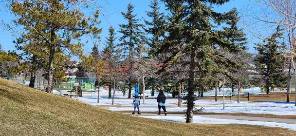
Child rollerblading through Prairie Winds Park
Discussing concepts with a community member at the open house
ENGAGEMENT |
Summary of What We Heard
Community members in Castleridge and Falconridge expressed pride in their neighbourhood’s cultural diversity. Many long-time residents spoke about the unique sense of belonging brought upon by decades of connection, and how multiculturalism is a defining strength of the area. Local leaders and business owners are deeply invested in improving the community, and believe existing assets such as Prairie Winds Park, school fields, and the Community Centre offer much by way of revitalization. Residents welcomed ideas like public art, beautification, and pathway upgrades as ways of strengthening community identity and connection.
At the same time, significant challenges were raised. Safety had proven to be a recurring concern with residents reporting increases in theft, drug use, and homelessness. Public spaces—especially alleyways, parks, and transit-adjacent areas—were described as poorly maintained and unsafe, particularly during winter months. Aging infrastructure, overcrowded housing, and inadequate recreational facilities have not kept pace with rapid population growth. Residents also commented on barriers to access—things like language differences and physical inaccessibility for seniors and people with disabilities.
Despite these concerns, there is clear opportunity to support equitable revitalization. While some were hesitant about large-scale densification, there was recognition of the need for more affordable, family-friendly housing integrated at an appropriate scale. They also recognize that, without action, there is a risk of further decline in quality of life, displacement of long-time residents, and the loss of trust in the City as a whole. However, with thoughtful interventions and ongoing engagement, this community has the potential to thrive.
LACK OF QUALITY
AMENITIES AND GREENSPACE
CULTURALLY DIVERSE
LOW PERCEPTION OF SAFETY
AMENITIES
HOUSING
An equitable community offers resources, opportunities, and services to those who are under-served.
CONNECTIONS
ENVIRONMENT
SAFETY
EQUITY | 4.1 Vision
Falconridge and Castleridge are ranked in the bottom 3% of Calgary’s equity index.
It was this fact that initiated our vision to improve equity within the community. In an equitable community, where the needs of marginalized groups are prioritized, we create better outcomes for everyone. Equity is not just the outcome but the guide to how our communities grow and evolve over time.
Housing Choice
We support a diverse range of housing types, including mixed-use and multigenerational living options, to address future growth but also to provide what is needed for the current residents of the community.
Resilient Growth
We plan for resilient growth on two fronts. First the environment by increasing environmental resilience through expanded tree canopy and green space that supports both ecological health and long-term community needs. Second, through the use of managing land use to accommodate growth in areas where it best serves the community.
Connection
We prioritize physical, social, and economic connection. This includes a safe and accessible active transportation network, complete streets, and community design that supports proximity to amenities. Proper distribution of amenities and placement of mobility networks are key to ensuring the community is connected within and to the rest of the city.
Our equity approach is grouped into five domains. Each domain is associated with data-driven metrics that allow us to monitor changes over time as our strategies are implemented.
1. Housing: Increase housing choice by dedicating land use Mixed Use, TOD, and Family Housing Typologies.
2. Connections: Provide more quality active transportation options to further diversify transportation choice.
3. Safety: Improve pedestrian safety by aligning intersection design to NACTO guidelines to reduce vehicle-pedestrian incidents.
4. Environment: Improve the quality of the environment by increasing overall tree canopy coverage and access greenspace.
5. Amenities: Increase the proximity of services and recreational amenities for all residents throughout the community.
CONNECTIONS
EQUITY | 4.3 Matrix
INDICATORS STRATEGIES
HOUSING
Mixed Use / TOD Typologies
Multigenerational Typologies
CONNECTIONS
Active Transportation Options
Pathway Network Quality
Proportion of Diverse Housing Typologies
Length and Number of Pathway Connections
SAFETY
Pedestrian Comfort
Intersection Safety
ENVIRONMENT
AMENITIES
Tree Canopy
Open Space Access
Number of Pedestrian Incidents
Percentage of Tree Canopy
Proximity to Amenities
Recreational Opportunities
Number of Dwellings Within 100m of Amenities
We developed this equity matrix to break down our strategy into three sections: Domains, Strategies, and Indicators.
The five domains—Housing, Connections, Safety, Environment, and Amenities—represent critical dimensions of equity that shape daily life in this community.
Each domain is paired with strategies like promoting mixed-use typologies, improving pathway network quality, or increasing tree canopy coverage.
To measure progress of these strategies, each domain includes a clear indicator to measure progress. This matrix provides a data-driven framework with which to evaluate how our interventions are improving equity.
EQUITY | Indicators 4.4
Proportion of Diverse Housing Typologies
We used the Simpson Diversity Index to quantify how evenly different types of housing typologies are represented within the community. A higher index indicates a more balanced mix, while a lower index indicates a dominant type. We used data from the 2021 Statistics Canada Census for our baseline calculations.
Length of Pathways and Number of Connections
We used GIS to determine the total length of pathways in the community and number of points where the pathways intersect. We then combined the data using a weighted analysis of 70% connections and 30% length.
We used data from the City of Calgary Pathways Map for our analysis.
Number of Pedestrian Incidents
We used research to determine the percent reduction of pedestrian traffic incidents after intersection interventions. We derived a conservative estimate of 25% reduction in incidents after changes.
The data for our baseline calculation was retrieved from the City of Calgary Traffic Incidents involving Pedestrians and Cyclists.
Percentage of Tree Canopy
We analyzed the available area for tree planting in all interventions, determining an average number of potential trees that can be added to the community, then converting to tree canopy based on an average tree diameter of 6m.
The data for our baseline calculation was retrieved from the City of Calgary Tree Canopy Map.
Number of Dwellings within 100 m of Amenities
We used a GIS spacial proximity analysis using 100m buffers around healthcare, schools, recreation facilities, shopping, and community services to determine the number before and after our interventions. We used Building Footprints and Amenities data from the City of Calgary for our analysis.
LAND USE
Making it easier for families to find housing that suits their needs and is close to shops and services.
LAND USE | Urban Form and Scale
URBAN FORM BUILDING SCALE
This map identifies the location of different urban form categories. These categories define the role and general use of land within specific areas of the community. Each category comes with a set of policies that align with those in the City of Calgary Local Area Planning Guide. Those policies apply in addition to any specific policies outlined in the plan. The urban form categories work alongside the building scale modifiers to create a future image of land use within the community.
This map shows building scale modifiers, which define the general height and massing of buildings within specific areas of the community. These modifiers shape how development feels at the street level and help manage the transition between different built forms. Scale modifiers work with the Land Use Bylaw to guide building height, density, and setbacks. The building heights identified on the map are the maximum allowable heights. These heights may not be achievable for all development applications.
LAND USE | Urban Form and Scale
POLICIES
5.1.1 Neighbourhood Family Urban Form Category
Neighbourhood Family areas are residentially oriented areas characterized by housing types that can support multi-family, and multi-generational family households. This is represented by a range of building scales. The built form supports proximal access to multi-modal transportation and public space is designed to support low to moderate volumes of pedestrian movement along the street.
Policy
a. Development in Neighbourhood Family areas of a community should support housing types and forms suited to multi-family households. These are limited to the following housing types:
(i) Single-detached homes with registered secondary suites;
(ii) Semi-detached homes and duplexes;
(iii) Stacked townhomes, and;
(iv) Apartments with at least 40% of units containing three or more bedrooms.
b. Neighbourhood Family areas should:
(i) be located within 100m of a transit route,and/or;
(ii) be adjacent to roads with multi-use pathways or dedicated bike infrastructure.
c. Public space and street design within the Neighbourhood Family areas should be designed to support daily life for all ages and abilities.
City of Calgary
City of Calgary
Limited Low-Modified Low Mid High
Neighbourhood Family Urban Form Category
LAND USE | Neighbourhood Family
LAND USE DISTRICT
Parcels located within the Neighbourhood Family urban form category will transition to a new Land Use District that limits new single-detached homes from being developed. This is necessary to encourage a greater diversity of housing types, support more efficient use of land and infrastructure, and align with the community’s goals to provide more adequate housing for those who already live there.
This Land Use District will speed up the development of housing that is more suitable for large or multigenerational families. This includes secondary suites, semi-detached homes, stacked rowhouses, and 3+ bedroom apartments. It will also mean that singledetached development must be evaluated on a case-by-case basis to ensure it is suitable with the Neighbourhood Family Category.
CanadaMortgageandHousingCorporation
This Land Use District will only affect future development, and not existing homes.
Secondary Suite
Stacked Rowhouse 3+ Bedroom Apartment
LAND USE |
Neighbourhood Family
5.2.1 Neighbourhood Family Land Use District
A new Land Use District will replace current M-CG and R-CG districts within the Neighbourhood Family urban form area. This Land Use District is called MultiResidential - Contextual Family (M-CF) and it is intended to provide more flexibility for gentle density while ensuring new development fits within the existing neighbourhood context.
Policy
a. The M-CF District provides for multi-residential development in a variety of forms that support large families, multi-families and multigenerational families.
b. The following uses are permitted in the M-CF District:
(i) Backyard Suite;
(ii) Duplex Dwelling;
(iii) Rowhouse Building;
(iv) Secondary Suite;
(v) Semi-Detached Dwelling, and;
(vi) Townhouse.
c. The following uses are discretionary uses in the M-CF District:
(i) Single Detached Dwelling.
d. Apartments with a minimum of 40% 3+ bedroom units may be excluded from certain land use bylaw requirements including height limits and parking minimums.
POLICY AREA
EQUITY INDICATORS
LAND USE | Community Hubs 5.3
SMALL-SCALE MIXED-USE
Community hubs are small mixed-use centres located in the heart of the residential neighbourhood. They bring essential amenities and services closer to where people live. They are designed to be walkable, accessible, and scale-appropriate.
The community hubs will include local shops and services like cafes, convenience stores, or medical offices on the ground floor while housing will sit above the ground floor. These hubs will have active frontages and storefronts will be located atgrade to be accessible for all.
Community hubs will be developed in areas of the community that are most lacking proximity to amenities, and where minimal commercial already exists. They will also be located along the new pathway network, and along transit routes in order to ensure they are safely accessible by any means of transportation.
As the hubs will be located within existing residential, buildings will maintain a maximum height of four storeys. They are also located within the Neighbourhood Family urban form category, therefore, development must also comply with the policies outlined in section 5.2.1.
Community hubs will reduce the need for long trips to access basic services, particularly benefiting seniors, families with young children, and residents without access to a car. Over time, these hubs will help shape a more complete and connected community where people can meet daily needs closer to home.
Community Hub at Falconridge Blvd. NE and Falshire Rd. NE
LAND USE |
Community Hubs
POLICY AREA
5.3.1 Community Hubs
Community hubs are small mixed-use centres located within the residential community. They are intended to provide local amenities and services within walking distance of residential areas, support social connection, and contribute to a more complete and inclusive community. Hubs are located in areas with limited access to amenities and along key active transportation and transit routes.
Policy
a. Community hubs should be:
(i) Located in areas identified as having limited access to local amenities and services, and;
(i) Connected to the community’s active transportation network, including multi-use pathways and sidewalks, and be accessible via existing or planned transit routes.
b. Development in community hubs should be oriented to the street, and ground entrances should be at-grade.
c. Community hubs should provide well-defined, on-site pedestrian routes to limit conflicts with vehicles. They shall include pedestrian-friendly design elements such as seating areas, street trees, weather protection, bike parking, and small gathering spaces.
d. Residential uses should be located above ground-floor commercial spaces.
e. Massing of buildings within community hubs should be compatible with the surrounding neighbourhood, with a focus on human-scaled development that supports an active public realm, and maintains tree canopy.
EQUITY INDICATORS
LAND USE | Activity Centres
LARGE-SCALE MIXED-USE
Activity Centres are large scale areas designed to facilitate mixed-use development, walkability, and higher-density living. They are located near strong transit connections and public amenities. They serve as hubs within the broader community, bringing together housing, retail, services, employment, and open spaces in a more compact, accessible form.
These centres can be envisioned as vibrant, community-oriented destinations which support daily needs and social interaction. They build on existing assets like nearby transit infrastructure and commercial areas while introducing new housing types and enhanced public spaces. This concentrated mix of uses not only supports local businesses and transit usage, but also helps address key community needs such as housing choice, accessibility, and inclusivity.
Sample Masterplan for the Prairie Gate Activity Centre
Pedestrian Street in the Prairie Gate Activity Centre
Sample Massing for the Prairie Gate Activity Centre
LAND USE |
Activity Centres
POLICY AREA
5.4.1 Activity Centres
Activity centres serve as compact, high-activity hubs that bring together housing, services, and public amenities in a walkable, transit-supportive environment. These policies guide their land use, design, and functionality.
Policy
a. Activity centres shall support a mix of residential, commercial, and institutional uses to promote vibrant, complete communities.
(i) Land use zoning in the area should enable medium-high density housing forms, prioritizing apartments and condominiums.
(ii) Development applications within activity centres must demonstrate how they contribute to walkability, transit usage, and access to daily amenities.
b. New developments must prioritize pedestrian connections to nearby transit.
(i) Major transit nodes within activity centres should be complemented with retail, community spaces, and higher density housing.
c. Activity centres must include publicly accessible open spaces such as plazas, parks, or green corridors that invite social gathering and community events.
(i) A min. target of 25% canopy coverage should be achieved in open spaces.
(i) Streetscapes should be designed with pedestrian comfort in mind including shade-giving trees, benches, lighting, and active frontage at ground level.
(ii) Art, cultural elements, and wayfinding features should be integrated into the public realm to reinforce local identity.
d. A range of unit sizes and types should be provided including 3-bedroom units suitable for families and multi-generational households.
EQUITY INDICATORS
Raised
Lanes
MOBILITY |
Pathways
MULTI-USE PATHWAYS RAISED BIKE LANES
The upgrades to the 5A network will take form as a multi-use pathway where space is available along arterial roads. These pathways will be implemented in areas where sufficient space allows for sidewalk widening without disturbing existing trees or root zones. These shared paths accommodate both pedestrians and cyclists, offering a flexible and inclusive solution that supports a range of active transportation users. By maintaining a treed buffer between the pathway and roadway, these routes also reduce exposure to traffic, enhancing user comfort and safety.
A raised two-way bike lane will replace a parking lane on primary local roads. This will keep cyclists safe while maintaining tree canopy along the sidewalk. Raised to the level of sidewalks, these lanes create a dedicated, physically separated space for cyclists, improving safety and predictability along busy local streets. Original tree canopy and sidewalk buffer is maintained, allowing trees to age along the corridors, providing shade and comfort for pedestrians. These raised bike lanes will also allow people using wheelchairs to get around the community without having to wheel on the road.
MOBILITY |
6.1.1 Pathways
Pathways play an important role in promoting safe and connected communities. As new routes are introduced or existing corridors upgraded, careful consideration must be given to how these networks interact with user experience and the urban realm. The following policies ensure that pathway design supports both mobility and environmental goals.
Policy
a. Two-way raised bike lanes should be located to preserve existing trees, to prevent loss of tree canopy.
b. Multi-use pathways should be implemented in areas where existing sidewalks can be widened without the removal of trees or significant impact on root zones.
c. Pathway alignments must prioritize safe separation between pedestrians and cyclists where space permits, using elevation, markings, or surface materials.
d. New tree plantings are to be incorporated where space allows, with the goal of increasing the overall tree canopy and providing future shade along active transportation routes and public transit stops.
(i) Vegetation adjacent to pathways and bike lanes must be selected and maintained to ensure clear sightlines and visibility between cyclists, pedestrians, and vehicles especially at intersections, crossings, and curves.
e. Pathway lighting should be provided based on usage patterns, safety needs, and must be DarkSky-approved fixtures to reduce light pollution.
(i) Lighting fixtures should direct light downward and be spaced to ensure consistent illumination along the route while minimizing glare for cyclists and pedestrians.
POLICY AREA
EQUITY INDICATORS
MOBILITY | Intersection Upgrades 6.2
MULTI-USE PATHWAYS
To create a cohesive 5A network and reduce pedestrian-vehicle conflicts, we will follow NACTO guidelines to redesign intersections for improved safety. Slip lanes will be removed, safety islands and central medians will be introduced to reduce traffic speed and probability of a vehicle/pedestrian collisions. Sloped ramps and pedestrian signal priority will also be added to improve accessibility and safety.
There are four major intersections where these improvements will be implemented. These intersections have been chosen due to the high prevalence of pedestrian/vehicle collisions, location along the 5A network, and their proximity to areas identified for future growth and development.
Intersection at Falconridge Blvd. NE and Falconridge Dr. NE
Intersection at Falconridge Blvd. NE and Falshire Way NE
MOBILITY |
Intersection Upgrades
POLICY AREA
6.2.1 Intersections
Thoughtful intersection design is critical for shaping the safety and accessibility of pathway connections. Enhancing these spaces with the pedestrian in mind can significantly reduce the conflict between pedestrians and vehicles, particularly in areas with high traffic volumes. These policies
Policy
a. Slip lanes shall be removed where possible to improve pedestrian safety, reduce vehicular speeds, and simplify crossing points.
b. All intersections should include sloped ramps to ensure universal accessibility for all users, including those with mobility impairments.
(i) Ramps should include the use of high visibility tactile indicators.
c. The use of leading pedestrian intervals (LPIs) are to be used where appropriate to allow pedestrians to start crossing before vehicles receive a green signal, improving safety at high-traffic intersections.
d. Pedestrian safety islands should be incorporated at intersections, where room allows.
e. Traffic medians should extend from safety islands where room allows as a traffic calming measure and create space for tree planting. They should be designed to:
(i) Allow for appropriate plantings that do not obstruct visibility for pedestrians or drivers, and;
(ii) Be drought-tolerant and low-maintenance to reduce long-term costs.
EQUITY INDICATORS
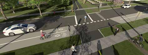
MOBILITY | Pedestrian Crossings
MID-CROSSINGS
To create a cohesive and continuous 5A network, targeted traffic calming interventions will be implemented at midcrossings, where multi-use pathways and raised bike lanes intersect with roadways. These interventions are critical for maintaining pedestrian safety across the network, particularly at points where pathways are segmented by vehicular traffic. Curb extensions, or bulb-outs, will be installed at key crossings to visually and physically narrow the roadway, encouraging drivers to reduce speed. In addition to slowing traffic, these extensions shorten the crossing distance for pedestrians and cyclists, improving visibility and minimizing exposure to moving vehicles. Where space allows, extensions may also incorporate special paving patterns, signage, and planting to reinforce their presence and further enhance pedestrian safety at these intersections.
Pedestrian Crossing at the Utility Corridor and Falshire Dr. NE
Pedestrian Crossing at the Utility Corridor and Falshire Dr. NE T-Intersection at 54 St. NE and Castleridge Dr. NE
MOBILITY |
Pedestrian Crossings
6.3.1 Pedestrian Crossings
These policies intend to improve pedestrian safety and connectivity by slowing vehicles down and increasing visibility at key pedestrian crossing points.
Policy
a. Mid-crossings upgrades shall be strategically placed at locations where high pedestrian use is anticipated, particularly along the newly proposed pathway network and Ridgeway Corridor Park.
b. Clear, high-visibility signage shall be installed at all mid-crossing locations to inform drivers of pedestrian crossings.
(i) Signs should include flashing beacons or advance warning signs to alert vehicles to the presence of pedestrians, particularly in areas of high foot traffic.
c. Bulbouts shall be installed on both sides at mid-crossing points to reduce crossing distance, increase pedestrian visibility, and provide safer refuge islands for pedestrians.
(i) The design of bulbouts should ensure unobstructed sightlines for pedestrians and drivers.
(ii) Bulbouts should be designed to integrate with landscaping and vegetation where possible
d. Pedestrian-scale lighting shall be installed at all mid-crossings to enhance visibility during nighttime and low-light conditions. Lighting must align with the policy in section 6.1.1.e(i).
e. All mid-crossings should be designed with accessible ramps and clearly marked pedestrian pathways, ensuring use by people of all abilities.
POLICY AREA
EQUITY INDICATORS
MOBILITY | Utility Corridor 6.4
RIDGEWAY CORRIDOR PARK
The Ridgeway Corridor project involves converting a utility corridor into a multi-use pathway that creates connection between the north and south. Running parallel to the multiuse pathway will be a gravel trail for gravel and mountain biking. The pathway will intersect with the 5A network at two points utilizing new mid crossing designs.
A new pedestrian bridge on the south end will span across McKnight Blvd, connecting to a desire path within the community of Temple, bridging the gap between the two communities. An eastward extension of the corridor on the south end will also connect to the existing dog park. Wayfinding will be utilized to map out the amenities along the route such as the community centre and our new community node. New features of the park will include a pump track, public art, pathway lighting, seating, and an extensive planting and vegetation plan. A fly-through of the park can be viewed here
Pedestrian Bridge over McKnight Blvd. NE Pump Track South of Falconridge Dr. NE
Wayfinding Signage
Utility Corridor
POLICY AREA
6.4.1 Ridgeway Corridor Park
These policies are designed specifically for the Ridgeway Corridor Park.
Policy
a. Planting must comply with utility provider clearance zones to maintain safety and access beneath power lines. Native or climate-adapted species should be prioritized to reduce maintenance needs.
(i) Short Zone (within 1m): Only shrubs and hedges under 2m tall.
(ii) Medium Zone (5m): Trees up to 4m at maturity or when pruned.
(iii) Tall Zone (10m+): Trees of any mature height permitted.
b. All lighting along pathways must comply with the policy in section 6.1.1.e(i).
(i) Motion-activated or dimmable lighting is encouraged in low-activity areas.
(ii) Lighting design should align with CPTED (Crime Prevention Through Environmental Design) principles to enhance safety and visibility for all users.
c. Wayfinding signage must be provided in English and min. two additional languages, based on local demographic data and community engagement.
(i) Use universal symbols, high-contrast text, and accessible formats.
(ii) Include gateway signs with maps at entrances and directional signs at key decision points.
(iii) Signage materials must be durable, vandal-resistant, and sustainable.
d. All pathways, seating, and park features shall comply with universal design principles, ensuring barrier-free access for people of all ages and abilities.
e. Rest areas with seating must be placed at regular intervals and integrated with vegetation and other amenities.
EQUITY INDICATORS
OPEN SPACE
Making it more comfortable and enjoyable to relax and gather in a nearby park.
PRAIRIEPARKWINDS
GROUNDSCRICKET
BISHOP MCNALLYHIGHSCHOOL
DOGPARK
Pick a Park
Micro Forests
Renaturalization
Boulevard Trees
OPEN SPACE | Microforests
MICROFORESTS
The City of Calgary’s Community Trees: School Planting Program is a yearlong, integrated curriculum designed to engage students from Grades 1 to 12 in environmental stewardship. The program culminates in the creation of a small urban forest on school grounds, transforming underutilized spaces into natural learning environments.
The City of Calgary will collaborate with schools to prepare the planting area and plant the trees. After the microforest is planted, students monitor the growth and health of the trees. This program develops a long-term connection between the students and the trees, instilling a sense of environmental responsibility and stewardship.
This initiative will help grow the tree canopy by using open space that is primarily vacant. The plantings will not affect the use of the play fields.
OTHER APPLICATIONS
The Microforests intervention can also be adapted to other areas in the neighbourhood where organizations commit to caring for the forests. One such location is the Calgary Police Services Headquarters. The program can be adapted to serve the needs of CPS by serving as a memorial forest or allowing members to plant a tree when they are sworn in.
A Microforest at Bishop McNally High School
OPEN SPACE |
Microforests POLICIES
7.1.1 Microforests
Microforests provide a flexible approach to increasing the tree canopy within a neighbourhood. They can be adapted to a variety of community contexts. This policy aims to lay the foundation for microforests in schoolyards while remaining open to be adapted for other uses.
Policy
a. Areas for tree planting must be determined in collaboration with the school board, teachers, and students to ensure locations are appropriate for long-term growth, student access, and ecological benefit.
(i) Microforests may be established in non-school locations where an organization or institution commits to long-term care, maintenance, and stewardship of the site.
(i) At institutional sites, microforests may be designed to serve commemorative functions or ceremonial tree planting programs to reflect the values and identity of the organization.
b. Selected planting sites must:
(i) Follow utility planting guidelines;
(ii) Maintain visibility and safety around pathways and school or community infrastructure, and;
(iii) If applicable, Align with existing schoolyard programming, recreation infrastructure, or outdoor learning spaces.
c. All trees planted in microforests must be native or climate-adaptive species.
d. Trees should be planted with an average mid density of 0.2 trees/sqm.
POLICY AREA
EQUITY INDICATORS
OPEN SPACE | Renaturalization 7.2
DEFINITION
PROCESS
GUIDELINES
The City of Calgary has naturalization guidelines that will guide the analysis and design of the renaturalized spaces.
The document outlines the benefits and principles of naturalization and details how to conduct a site analysis to determine the appropriate plant mixes for a given space, based on location, sun, slope, and shade.
A renaturalized Mcknight-Falconridge Off-Leash Dog Park
City of Calgary Naturalization Guidelines (2017)
OPEN SPACE |
Renaturalization
POLICIES
7.2.1 Renaturalization
Renaturalization is the restoration of native landscape to a developed area. It offers and opportunity to support local ecology, reduce park maintenance, and reconnect open spaces with their natural context. The following policies outline a phased strategy for implementing naturalization in the Falconridge/Castleridge/ Westwinds community. They provide direction on where and how to introduce native plantings, how to evaluate pilot sites, and how to ensure that naturalized areas remain accessible and valued by residents.
Policy
a. Renaturalization shall be prioritized in locations with suitable soil, moisture, and drainage conditions, including but not limited to stormwater ponds, roadside boulevards, and park edges.
b. Appropriate native plant species shall be selected based on site-specific characteristics in accordance with the City of Calgary’s Naturalization Guidelines.
c. Where possible, portions of historic wetlands shall be reintroduced through minor grading interventions and the establishment of native wetland plant species.
d. New naturalized areas shall incorporate clear educational signage about the benefits of renaturalization to promote community awareness and understanding of the project.
e. Naturalized areas shall be designed to maintain visual interest year-round and remain accessible and safe for public use with pathways and sight-lines considered in all design concepts.
POLICY AREA
EQUITY INDICATORS
OPEN SPACE | Parking Lot Conversion
TRANSFORMING PARKING
Two underutilized parking lots were identified in the analysis of the Westwinds neighbourhood: the parking lot at the Calgary Police Headquarters, and the parking lot at the Superstore. Parking lot conversions will transform a portion of the underutilized lots to park spaces, while maintaining the used portions of the lots. These conversions will introduce green space and tree canopy into areas with limited park access, improve surrounding pathway connections, and reduce the permeability of the surfaces. Park design elements should include naturalization and microforests. Thorough consultation and coordination with property owners and transportation engineers will ensure the functional parking needs are maintained.
CPS LOT
The CPS lot provides an opportunity as it lies on public lands and is publicly occupied. The location of the Youthlink Interpretive Centre on the property also creates the potential for a partnership with the museum to create a park space that can extend their programs into the outdoor space. The design of the space could include flexible seating and interpretive signage, that reflect their focus on education and safety.
A reimagined park replacing a portion of the CPS Parking Lot
Youthlink Interpretive Centre located at CPS Headquarters
OPEN SPACE |
Parking Lot Conversion
POLICY AREA
7.3.1 Parking Lot Conversions
Parking lot conversions are an adaptive strategy to transform portions of underutilized paved parking areas into functional park spaces. This approach responds to the limited tree canopy and permeability within the Westwinds commercial neighbourhood. It also provides the opportunity to better connect future residential areas to commercial and offices by integrating with the nearby activity centres.
Policy
a. Parking lot conversions shall be developed in consultation with landowners, users, and interested parties to ensure alignment with operational needs and community goals.
b. Parking lot conversions should be prioritized on publicly owned lands where parking supply exceeds demand.
c. An infrastructure and servicing analysis shall be completed prior to design, to assess existing utilities, drainage, lighting, access, parking, and circulation conditions, and to inform the feasibility and scope of conversion.
d. Design of converted areas should support an increase of tree canopy.
e. Design of converted areas should be flexible and support a multitude of uses, including programming and partnerships with adjacent institutions.
f. Converted areas must provide proper mobility connnections with neighbouring residential and commercial areas. Pathways should form a seamless integration with activity centres.
EQUITY INDICATORS
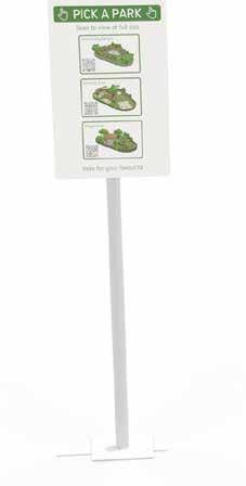
OPEN SPACE | Pick a Park Program
PICK A PARK
Pick a Park is an innovative participatory program that empowers residents to shape the future of the pocket parks in their community. Developed in response to community feedback, the program invites residents to choose from three design options at each pocket park. These options are uniquely designed to reflect local needs, and may include things like seating, play elements, natural features, and gathering spaces. The options are accessible through on-site QR codes that link to full-scale Augmented Reality visualizations. Residents can then vote on their preferred design which is later implemented. This program is a way to give community members a sense of ownership of their park spaces, strengthening the care the community will have for the parks. Try for yourself!
Pick a Park Concept at Castleridge Blvd. NE and Castlefall Way NE Pick a Park
OPEN SPACE |
Pick a Park Program
POLICIES
7.4.1 Pick a Park Program
Pick a park is an innovative participatory program empowering local residents to shape the future of pocket parks in their community. The program provides better access to amenities within residential neighbourhoods, providing customized spaces for the community to eat, play, or rest. These policies provide a framework to guide the implementation and expansion of the Pick a Park program.
Policy
a. Pocket parks included in the Pick a Park program will be selected after a thorough analysis of conditions and prioritized based on amenity need. The analysis should include engagement with the community.
b. Each pocket park in the program should offer three distinct design options that reflect needs identified through the analysis of each site. Design options shall include input from City departments, interested parties, and maintenance teams to ensure they can be feasibly implemented.
c. Park elements should be designed to be inclusive and durable.
d. Design options must be made accessible to the public through on-site QR codes that link to full-scale AR visualizations, supported by clear instructions.
e. A minimum engagement period shall be defined for each voting window to ensure broad community participation, including outreach to residents of all ages and abilities.
f. Final design selection shall be determined by majority community vote and implemented in alignment with the City of Calgary park development standards.
POLICY AREA
EQUITY INDICATORS
AMENITIES
CONCLUSION HOUSING
CONNECTIONS
ENVIRONMENT
SAFETY
Summary of Interventions
SUMMARY
In this project, we aimed to recommend strategies, interventions, and policies intended to increase equity within the Falconridge, Castleridge, and Westwinds community. After extensive research, analysis, community engagement, and professional feedback, we have developed the strategies as visualized below.
In the following pages, we will explain our methods and final calculations to determine a final equity increase after our implementations.
Land Use
Raised
CONCLUSION | Final Metrics
This metric utilizes the Simpson Diversity Index—a scientific measurement primarily used in biology to measure the diversity of species. In the context of housing, it quantifies how evenly different types of housing typologies are represented within a community. A higher index indicates a more balanced mix of forms, rather than dominance by one type alone. Our baseline data came from the 2021 Statistics Canada Census, where about 60 percent of the community was made up of single-detached homes.
The diversity index of the baseline is 63 percent. After implementing our changes, both overall housing increased as well as the proportion of different types of housing, bringing our index to 79 percent. This represents a percentage change of 26 percent.
CONCLUSION | Final Metrics
CONNECTIONS
We used GIS to measure the total length of pathways in the community, and the total number of points where two pathways intersected or created a connection to an edge of the community. The rational is that it is important to have a greater length of pathways, but it is also important to have a strong network of pathways. Both metrics were combined in a weighted analysis (70 percent towards network strength, 30 percent towards total length) to determine an index of pathway quantity and quality.
An overall increase of 153% was achieved by adding 25 new connections to the existing 15 and 10.5 km of new pathway to the existing 8.6 km network.
EXISTING CONDITIONS AFTER INTERVENTIONS
Final Metrics
SAFETY
Studies show varying results of the effects from safety islands. The US Department of Transportation (n.d.) states a 56% reduction after the implementation whereas Bowman & Vecellio (1994) have an 18.4% decrease in central business districts and a 58.2% reduction in suburban areas.
Given the varying and complex data from a variety of studies done and our intersections change with multiple interventions, we hope to see a conservative estimate reach a 25% reduction in pedestrian/ vehicle incidents at the upgraded intersections.
CONCLUSION |
Final Metrics
ENVIRONMENT
To estimate the potential tree canopy coverage in the community, we began by determining the canopy size of a typical young tree. With a 6-meter diameter canopy, we get a canopy area of approximately 28.3 square meters per tree. Next, we identified the total area available for tree planting through our interventions.
To estimate the number of trees that could be planted in the area, we applied a tree density value of 0.2 trees per square meter for areas like the schools. A lower density of 0.012 trees per square meter was used for areas that were naturalized. All trees were totaled from our interventions 10,685 and multiplied by our typical canopy size per tree of 28.3 square meters.
We calculate a total of 302,400 square meters of tree canopy added. When compared to our baseline of 425,000 square meters we calculate a total change of 71%.
CONCLUSION | Final Metrics
AMENITIES
We determined the number of dwellings within 100 metres of amenities using a GIS analysis. Utilizing layers of data for building footprints and amenity points including healthcare, schools, shopping, and community services.
After filtering down the size of the building footprints to omit any small buildings (garages/sheds) and large buildings (schools, warehouses), we were left with an approximation of individual dwellings. Finally, we created a 100 metre buffer around the amenity points both before and after our interventions and summed the total number of dwellings within the radius.
Before our interventions there were approximately 980 dwellings within 100 metres of amenities. After our interventions there are approximately 3000.
EXISTING CONDITIONS AFTER INTERVENTIONS
CONCLUSION | Final Metrics
FINAL SCORE
After each individual equity metric was calculated— covering elements of housing diversity, pedestrian safety, tree canopy coverage, pathway connectivity, and proximity to amenities—we averaged the results to determine the overall impact of our interventions. This comprehensive approach allowed us to capture a holistic picture of how equity was improved across multiple aspects of daily life. By balancing environmental, social, and spacial considerations, we ensure that no single domain dominated the outcome.
The result was a total average equity increase of 102 percent across the five domains. This significant improvement reflects not only the effectiveness of our targeted strategies but also the strength of an equity-driven planning framework. It demonstrates that when interventions are grounded in community feedback and supported by data, meaningful progress can be made towards more inclusive, connected, and livable neighbourhoods.
CONCLUSION | Application
FUTURE PROJECTS
While this equity framework was developed specifically for the unique challenges that the Falconridge, Castleridge, and Westwinds community faces, it is a process that can be applied to other communities in Calgary in the future. By using data-driven equity measurements to guide planning decision making, based on a thorough analysis of the community, this system can change the way that equity-based planning is done. By identifying key equity domains, municipal planners and community organizers can collect locally relevant data to assess where gaps exist and which areas are most in need of intervention. The metrics used for this project can be adapted for any neighbourhood using publicly available datasets. These indicators provide an objective baseline that helps communities understand not just where inequities exist, but how to measure progress over time.
Importantly, the process is not just technical but participatory. When paired with community engagement, these metrics can validate lived experiences, uncover new insights, and ensure that strategies are both evidence-based and responsive to local needs. Applying this approach across Calgary allows for equitable resource allocation, ensuring that neigbourhoods facing systemic disadvantages receive the support they need.
CONCLUSION
BIBLIOGRAPHY
BACKGROUND RESEARCH
Bowman & Vecellio. (1994). Effect of Urban and Suburban Median Types on Both Vehicular and Pedestrian Safety. Transportation Research Record, 1445, 169–179. https://onlinepubs.trb.org/Onlinepubs/trr/1994/1445/1445.pdf Canada Mortgage and Housing Corporation. (2025). Housing Design Catalogue https://www.housingcatalogue.cmhc-schl.gc.ca/ City of Calgary. (2021). The Guide for Local Area Planning. https://www.calgary.ca/planning/local-area/guidebook.html Enmax. (2025). Trees and power lines. https://www.enmax.com/outages-and-safety/safety-guidelines/trees-and-power-lines NACTO. (2025). Urban Bikeway Design Guide, Third Edition https://nacto.org/publication/urban-bikeway-design-guide/ NACTO. (2025). Urban Street Design Guide. https://nacto.org/publication/urban-street-design-guide/ US Department of Transportation. (n.d.). Medians and Pedestrian Refuge Islands in Urban and Suburban Areas. https://highways.dot.gov/ safety/proven-safety-countermeasures/medians-and-pedestrian-refuge-islands-urban-and-suburban-areas
SUPPORTING POLICY
Calgary Metropolitan Region Board. (2022). Growth Plan https://www.calgarymetroregion.ca/growth-and-servicing-plan
City of Calgary. (2005). Transit Oriented Development Policy Guidelines. https://www.google.com/url?sa=t&source=web&rct= j&opi=89978449&url=https://www.calgary.ca/content/dam/www/pda/pd/documents/transit-oriented-development/tod-policy-guidelines.pdf
City of Calgary. (2017). Naturalization Guidelines. https://w ww.google.com/url?sa=t&source=web&rct=j&opi=89978449&url=https://www. calgary.ca/content/dam/www/csps/parks/documents/planning-and-operations/naturalization-guidelines.pdf
City of Calgary. (2020). Calgary Transportation Plan 2020. https://www.calgary.ca/planning/transportation.html
City of Calgary. (2020). Municipal Development Plan 2020. https://www.calgary.ca/planning/municipal-development-plan.html
City of Calgary. (2025). Connect: Calgary’s Parks Plan (Draft). https://engage.calgary.ca/parksplan
DATA SOURCES
City of Calgary. (2025). City of Calgary’s Open Data Portal. https://data.calgary.ca/