At Third Places Studio, we acknowledge and pay our respects to the traditional territories and enduring presence of the Indigenous Peoples of the Treaty 7 region in Southern Alberta. This includes the land on which we stand, which has been a site of human activity for thousands of years. It is the home of the Blackfoot Confederacy, comprising the Siksika, Piikani, and Kainai Nations; the Tsuut’ina Nation; and the Stoney Nakoda Nations, including the Chiniki, Bearspaw, and Goodstoney First Nations. We also recognize the significant heritage and leadership of the Métis Nation of Alberta, (District 5 and 6), whose contributions continue to influence our community. In honoring these lands, we affirm our commitment to moving forward in partnership with Indigenous communities in a spirit of collaboration and reconciliation.
ACKNOWLEDGMENTS
Third Places Studio extends heartfelt thanks to Professor Dr. Beverly A. Sandalack and the steering committee members for their invaluable feedback, support, and guidance during the development of this project
“At Third Places Studio, we envision transforming community spaces into vibrant ‘Third Places’ that foster social connection and community strength.”
Our team at Third Places Studio brings a blend of expertise and innovative approaches to community planning, deeply rooted in understanding local needs. Our methodology is comprehensive and inclusive, ensuring that every plan we create is not only tailored to the community’s unique characteristics but also forward-thinking and sustainable. With our expertise in navigating legal frameworks and our commitment to long-term partnership, we offer more than just planning solutions; we offer a vision for a community that is vibrant, inclusive, and reflective of its unique character. We are a team dedicated to bringing this vision to life in Coach Hill and Patterson Heights.
Benjamin Bailey Senior Planner, City of Calgary
Asia Walker, Planner, City of Calgary
Eric Schertzer, Urban Designer, Stantec
Dr. Beverly A. Sandalack University of Calgary
Soumya Shashidharan, B.Arch 19, M.Plan 24
Harjee Singh, B.Arch 20, M.Plan 24
Kaitlyn Vandenbilche, BA 22, M.Plan 24
As part of the Citizen + Students program through the University of Calgary’s School of Architecture, Planning and Landscape, our team at Third Places Studio collaborated with the Coach Hill and Patterson Heights Community Association. Together, we developed a Community Improvement Plan and Implementation Guide.
Coach Hill and Patterson Heights are two well-established neighborhoods in Southwest Calgary that are currently facing several challenges. These include a lack of community identity, fast-moving traffic along Old Banff Coach Road creating highway conditions that act as a barrier between the communities, and an outdated, car-oriented commercial area that lacks modern urban design elements and pedestrian-friendly spaces. Additionally, while the area boasts extensive green spaces, parks, and trails, the interfaces are often uninviting, with disconnected and poorly lit paths and sidewalks.
This report presents the contributions of Third Places Studio to the redevelopment of Coach Hill and Patterson Heights.
Our involvement ranged from critical site analysis and conceptual design to the development of final design solutions and actionable recommendations. These recommendations stem from thorough research, our professional insights, and valuable feedback from community residents and our Steering Committee.
Our strategic recommendations aim to tackle the identified challenges and leverage the opportunities within these communities. They include:
• Enhancing connectivity and the quality of the public realm to promote a pedestrian-friendly environment.
• Revising land use policies to increase density.
• Developing a new commercial hub complete with a vibrant main street.
• Addressing traffic and safety concerns on Old Banff Coach Road.
• Enhancing interfaces and improving existing park conditions.
• Establishing cohesive pedestrian connections among the three key nodes within the community.
These strategies are underpinned by policy recommendations that provide clear guidance for achieving the proposed improvements. Our approach carefully considers the unique context and character of Coach Hill and Patterson Heights, aiming for a balance that meets the diverse needs of the community. This document details the proposed enhancements and serves as a guide for future development efforts.
TABLE OF CONTENTS
1. INTRODUCTION
This report offers a comprehensive analysis and series of proposals aimed at sustainable redevelopment, growth, and connectivity for the community of Coach Hill and Patterson Heights. It is crafted as part of an academic exercise within the PLAN 630 Advanced Professional Planning Studio at the University of Calgary’s School of Architecture, Planning and Landscape. In compliance with the City of Calgary’s Municipal Development Plan (MDP), this document presents a variety of ideas, strategies, interventions, and policy recommendations. It serves as a visionary document, incorporating extensive community engagement and conceptual proposals that the community can adopt and adapt for future planning initiatives.
The following scope describes the work that will be completed within the timeline of the project:
• Detailed site analysis which includes, physical features, environmental features, built form, infrastructure etc
• All the mapping and basemaps for the analysis
• 3D Model of the community
• Community Engagement
• Conceptual Designs and Interventions
• Land Use Policy Recommendations
• Intervention details
• Densification concepts and land use changes
• Road Improvements
• Public Realm improvements
• Open Space improvements
• Virtual Reality Component
• Physical Model of the Community
All the interested parties for the Community Improvement Plan is as follows:
In this project, we reviewed all applicable existing policies and plans for this area to understand the current policy context and future vision already set out for this community. This review ensured that we included all essential elements, providing a solid background to guide the development of the Community Improvement Plan in all phases. It’s a practical step to ensure our project aligns with the community’s goals from a planning perspective and is well-informed by existing policies.
Applicable Planning Documents identified by our team to be looked into the project include:
Municipal Development Plan (MDP) – 2009
Calgary’s Municipal Development Plan (MDP) is a statutory document under the MGA, regulating land use for an optimized environment. It covers future land use, development, transportation, and services in Calgary and adjacent areas. MDP also includes Calgary Transportation Plan and Community Guidebook regulates the transportation systems and community development.
The Patterson Heights (Strathcona Cell “A”) Concept Plan – 1991
The Patterson Heights Concept Plan summarizes past development in Patterson Heights, outlining a Land Use Concept Map and policies to guide future decisions on undeveloped lands. It aims to balance community and landowner interests while addressing problems from earlier developments.
East Paskapoo Slopes Area Structure Plan (Aspen Village) – 2000
The East Paskapoo Slopes plan aligns with Council-approved documents, prioritizing protecting environmentally significant areas, promoting development sensitive to the natural setting, and emphasizing slope-adaptive designs to minimize visual impact on sloped areas and ridge lines.
West Springs Area Structure Plan – 2012
The West Springs Area Structure Plan envisions the development of 370 hectares in Calgary’s west sector. Emphasizing walkability, access to amenities, and environmental conservation.
Complete Street Guide
Complete Street Guides in Calgary are designed to promote safer, more accessible, and environmentally friendly transportation options. They provide comprehensive guidelines for designing streets that accommodate all users, including pedestrians, cyclists, motorists, and transit riders.
Coach Hill and Patterson Heights Community Association
City of Calgary
Federation of Calgary Communities
Community Members and Residents of CHPH
Business Owners of CHPH
This Community Improvement Plan unfolds over four distinct phases. Phase I involves a community walkabout to gather insights and perspectives from residents. Phase II focuses on site analysis and research, supplemented by model making and a community workshop session to foster collaboration and input. Phase III is dedicated to concept development, where ideas begin to take shape based on earlier feedback.
Finally, Phase IV culminates in the presentation of final recommendations during an open house, followed by a formal presentation to the steering committee.
1.5 PROJECT SCHEDULE
Phase 1 Project Understanding Orientation
Review of Planning Context and Legal Framework
Updating of Data from SANDS
Creation of Base Maps
Site Visit
Image Collection and Filing
Phase 2 Research and Analysis
Environmental Analysis
Historical Evolution/Timeline
Land Use/zoning and Functional Analysis
Block Type, Housing, and Commercial/Institutional Building Typology (Inventory of Existing)
Park and Open Space Inventory and Analysis
Infrastructure Analysis
Circulation (Transit, Bike routes, Walkability, etc.)
Traffic Study
Synthesis of Analysis (Issues, Opportunities, and Constraints)
Compilation of Presentation
Presentation to the Steering Committee #1 (Analysis)
Community Workshop Preparation
Community Workshop (On-site)
Phase 3 Modeling
Coordinate with Colleagues to Assign Tasks
Digital Modeling
Physical Model Building
Phase 4 Draft Concepts
Clarification of Issues, Opportunities and Constraints
Development of Goals and Objectives (In Response to Synthesis of Analysis)
Land Use and Growth/Evolution Concept Development
Housing Development Strategy, Comparing Existing and Propsoed Housing Stock (Based on Analysis)
Urban Design and Development Concepts for a Commercial Node
Master Plan for Open Spaces and Natural Areas
Mobility and Urban Design Concepts (Plans and Smaller Vignettes or Diagrams)
Consolidation of Preliminary Conceptual Design and Guidelines
Compilation of Presentation
Presentation to the Steering Committee #2 (Draft Concepts)
Phase 5 Final Presentation
Development of Final Design Ideas (Based on feedback from the Steering Committee)
Final Land Use and Development Plan
Preparing the Agenda for Open House
Preparing Posters for the Open House
Revisiting the Model Based on the Final Concept
Preparation for Open House
Presentation to the Community in the Public Open House
Compilation of Feedback from the Open House
Compilation of Presentation
Final Presentation to the Steering Committee
Phase 6 Final Documents and Approval
Incorporation of Feedback and Revisions
Final Report Compilation
Final Submission of Plan
Community Walkabout
and Analysis
Public Engagement
Coach Hill Patterson Heights (CHPH), nestled in the picturesque southwest quadrant of Calgary, is a thriving residential enclave with a rich history and a vibrant community spirit. Annexed in 1956, this neighborhood began to take shape in the late 1970s, and over the decades, it has evolved into a harmonious blend of single detached dwellings, townhouses, and apartments. The area’s name itself pays homage to its historical significance, as it is situated along the Old Banff Coach Road, once a crucial route for travelers heading to the iconic Banff National Park.
2. ANALYSIS
2.1 FUNCTIONAL ANALYSIS
Functional analysis was crucial in understanding the community’s layout. Two main roads, Sarcee Trail SW and Bow Trail SW, create significant barriers within the area. Furthermore, Old Banff Coach Road cuts through the middle of the community and provides the main vehicular access to the community. The initial walkthrough highlighted that it forms a more significant divide between the two communities than their actual boundaries, with limited pedestrian permeability along residential streets entering the community from the west. Coach Hill Plaza was identified as a potential central commercial node. Additionally, there were opportunities for two community hubs: the existing gathering space in Patterson Heights and a planned Outdoor Recreation Hub in Coach Hill. The area features notable landmarks such as Odyssey Towers, which are visible outside the community. And the CFCN Tower, which offers beautiful city views.
SARCEETRAILSW
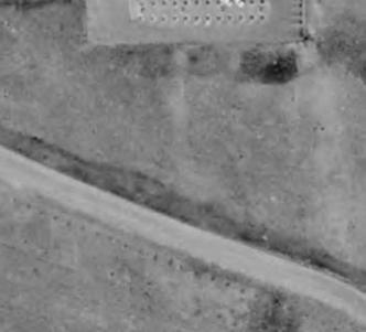
The series of aerial images showcase the urban morphology of Coach Hill and Patterson Heights in Calgary over a span of several decades. Urban morphology is the study of the form and structure of urban spaces and the processes of their formation and transformation. Here’s what the images indicate about the evolution of this area:
The area is largely undeveloped, dominated by natural landscapes and various acreages.
Development has begun to encroach upon the area. There is a noticeable expansion from the east, with a road infrastructure starting to take shape, evidenced by the Sarcee Trail SW.
1984: There is substantial development.
Residential buildings are visible, particularly around the New developed Old Banff Coach Rd. The arterial roads are more pronounced, directing traffic flow in and out of the area.
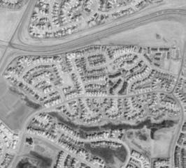
1995: The area has filled in significantly with residential development. The texture within the development area is denser and the Olympic Village on the site is major development.
1962: The pattern of urban sprawl is evident, with a denser, more intricate road network.
Present: The area fully developed with a complex network of roads, residential zones, green spaces, and other commercial area. Not much developed after 2005.
From these images, it can be inferred that Coach Hill and Patterson Heights have transitioned from a sparsely developed region to a well-established suburban area. Over time, infrastructure has expanded, residential areas have become denser, and commercial zone have been established, creating a auto-oriented urban environment. Also, rapid development happened around the 1984 Olympics. The development patterns suggest a suburban development style typical of the late 20th and early 21st centuries, characterized by low to medium density residential areas, reliance on vehicular transportation, and the integration of green spaces.
The population of Calgary is growing exponentially, but the population in Coach Hill and Patterson Heights remains stable. This is due to the City of Calgary categorizing it as an established community, with no anticipated growth.
Currently, the population of Coach Hill and Patterson Heights is 7,420 residents, with an average household size of 2.2, compared to Calgary’s average household size of 2.6. Additionally, Coach Hill and Patterson Heights has a lower proportion of families with children at 36%, compared to 44% in the wider Calgary area.
The graph suggests that around 85% of people use cars as their daily mode of transport, around 3% walking, and around 5% taking transit.
2.5 SCHOOL ENROLLMENT
Due to the large percentage of families with children living within the community, understanding options for education was important. Eight schools serve the community, but they are outside the community itself. As seen in the school driveshed analysis, all schools are at least a 5-minute drive from the community. This means walking is not the most feasible option, especially for children crossing major roads like Bow Trail. This means the commute for most school-aged children requires a car, school bus, or public transit. While most of the schools have experienced a decrease in enrollment, there has been a significant 54% increase in enrollment for grades 10-12, and many of the existing schools have reached their capacity.
Vincent Massey
Bowness
The community has limited amenities within it. They are serviced by one fire station located in the community. St. Martin’s church is the only place of worship. Coach Hill Plaza has the Coach Hill Medical Clinic, a pharmacy, a dental office, and a physiotherapist, which community members feel are assets. However, the nearest hospital would be driving to Foothills Medical Clinic or the Alberta Children’s Hospital. No full-sized library exists within 3km, with the closest being the Nicholls Family Library in Westbrook; however, the community does have an abundance of little libraries, most of which exist in Coach Hill compared to Patterson Heights. The Former CHPH Community Association used to be located within the community adjacent to Prominence Park; however, it vacated in 2005. Since then the CA has not had a physical building allocated within the community, with events occurring in other locations. Overall, this means that the community members must leave the community to access various amenities, some of which are not within walking distance.
Food Systems
The community could be considered a food desert, as it lacks access to grocery stores within walking distance. The nearest option is the Sobeys in Strathcona, which is around 2km away and requires crossing Bow Trail. The community is already responding to this through partnerships with Calgary EATS and other local food suppliers to host a weekly Farm Stand in Prominence Park. This initiative offers community members access to local and seasonal produce.
25 min walk Strathcona Square Sobeys
Physical Features - Topography (slope, contours)
Site Sections
Bow River to the Patterson Dr SW High Point
Sarcee Trail to Prominence Way Retirement Community
Across the entire community, there is quite a bit of topography, with some areas having steep slopes of over 25%. Many of these slopes are concentrated east of the site, going towards Sarcee Trail or north along the Paskapoo slopes leading down towards the Bow River. Ideally, these areas should not be developed, as they lead to accessibility and slope stability concerns. Despite this, some homes have been built on these conditions, and things like driveways are left relatively inaccessible, for example, along Coach Hill Rd. SW. Additionally, some areas of the community’s pathway network, such as the Nilo Trail Pathways, follow these slopes, leading to minor issues for pedestrian usage, especially during winter.
2.7 NATURAL ENVIRONMENT
Open Space Types
Coach Hill and Patterson Heights have an abundance and variety of open and green spaces across the community, with 95.3 hectares of open spaces making up nearly 30% of the total community area. In this report, Open Space has been categorized into five types. They range from more natural areas, including remnant habitat patches such as Aspen Forest or Grasslands. Unprogrammed open spaces under the powerline that run through the site has opportunities for programming/use. Outdoor recreation spaces also act as flexible spaces for community events like outdoor movie nights, which community members love. Manicured green spaces like those around major roads like Bow Trail. And quite a few playgrounds spread across both communities. What was found in this study is that the community hosts a diverse variety of spaces which are connected, for the most part, quite well through the robust pathway network.
Much of the Paskapoo slopes to the north of the community fall within the Environmental Protection Area, meaning additional development is restricted. A single dry detention pond for stormwater management exists in the southeast corner near the intersection of Sarcee Trail and Bow Trail. Open
BOWRIVER
Space Types
Overall, the urban forest coverage is high, more than double the City of Calgary’s average. However, mapping out the public tree canopy revealed gaps in street tree coverage. This led to a closer look into coverage and quality. There is excellent tree coverage in the natural areas near the Paskapoo slopes and along streets like Coach Hill Road. The amount of naturalized areas is likely positively skewing the canopy coverage, as significant gaps were identified along major roads like the north half of Old Banff Coach Road, a trend also occurring in other areas across the community. This reveals an opportunity to increase connectivity across the urban forest canopy and the open space network.
OLD BANFF COACH ROAD
BARRIERTOECOLOGICALSYSTEMS
SARCEETRAILSW
Barriers to Connectivity
Ecological Connectivity
Fragmentation of habitat, with habitat patches remaining mainly only in sloped areas
Topography
Topography can be a barrier to accessibility in public spaces like Nilo Trail
Major roads act as barriers to ecological connectivity to the more extensive open space network like Edworthy Park
Diverse Open Space Network
Prominence Park is used for community gatherings and events
Forest
Good street tree cover on streets like Coach Hill Rd and portions of Patina Dr
Gaps in the street tree coverage on major roads like Old Banff Coach Road
A significant part of understanding the public realm and the pedestrian experience in the community is around walkability. A walkshed analysis was done around the existing Coach Hill Plaza. In theory, most people within the community have good walking access to this central point, with most residential areas within a ten-minute walk. Assessing the condition and experience of walking across the community was used to help understand why people may not choose to walk here.
Disconnected Sidewalk and Pathway Network: Across the entire community, there are large disconnects in the consistency and connectivity of sidewalks and pathways, with many streets only having a single sidewalk. As a result, pedestrians will often meet dead ends or need to cross the road more frequently, which can also impact safety.
Impermeable Residential Streets: Particularly in Coach Hill, there are quite a few high wooden fences around residential areas, and most of the residential along Old Banff Coach Road have sound barriers along the sidewalks. Additionally, many of the larger developments are inwardfacing, creating an impermeable street condition and reducing the public realm’s activation.
Topography: The changing topography across the community makes it difficult for walking and wheeling around the community. During the team’s initial site walkabout with the Community Association, it was apparent how snow and ice and the lack of snow clearing can make these conditions even worse.
Auto-Oriented Design: The community is quite autooriented overall, and there are many thruways such as Old Banff Coach Road. The impacts, including increased vehicle speeds and noise, can be uncomfortable and imposing for a pedestrian walking alongside the road, especially where there is little or no buffer between them.
As the City of Calgary is drafting the new Connect: Calgary’s Parks Plan, there are quite a few goals around the provision and access to parks and open spaces, with which the team compared CHPH’s current state. Overall, with nearly 100 hectares of open space, the community has quite an excellent open space provision that far surpasses the City of Calgary’s goals of 2 hectares of open space for every 1000 people (Park People, 2021) for the current population size. As a part of the City of Calgary’s Playspace Optimization Program, a benchmark of 1 playground for every 200 kids under twelve was developed (City of Calgary, n.d.). Coach Hill is doing better than this. Better than this. However, Patterson Heights could do with at least one additional playground. The City of Calgary also has goals for everyone to be within 400 meters of open space (Geddes, 2018). A walkshed analysis found that not everyone is within a 5-minute walk to a park space, let alone to multiple kinds of open, green, or recreation spaces.
Walksheds from Parks and Open Spaces
Provision of Open Space
BOWRIVER
OLD BANFF COACH ROAD
City’s GOAL:
2 ha / 1000 people
Coach Hill Patterson Heights:
2 ha / 156 people
Provision of Playgrounds
City’s GOAL: 1 / 200 kids under 12
Patterson Heights: 1 for 230 kids
Coach Hill: 1 for 124 kids
Access to Green Space
City’s GOAL: Access to Parks Within a 5 min Walk (400m)
Coach Hill Patterson Heights: Does not meet goal
Sidewalks/Pathways Parks
Pedestrian Experience
Streetlights and city-maintained seating are well distributed across the community, with minimal gaps in public spaces like the Outdoor Rec Hub, near the CFCN Tower, and around some of the larger gated developments. These areas are further from the roads or where homes and alleys back onto the public spaces. In these areas, having additional seating and lighting would help with accessibility, safety, and pedestrian comfort.
Street Lights + Public Seating
BOWRIVER
OLD BANFF COACH ROAD
Pedestrian Experience
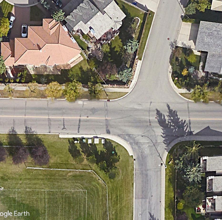
Most accidents involving at least one pedestrian or cyclist occurred along Old Banff Coach Road, particularly at major intersections or areas with more significant slopes, thus decreasing visibility. Major vehicular accidents are reported at the intersection of Old Banff Coach Road and Bow Trail. This again speaks to the dangers of auto-centric design on the pedestrian experience and the issues around Old Banff Coach Road walkability.
Traffic incidents
Total Traffic Incidents (since 2016)
Coach Hill Patterson Heights
OLD BANFF COACH ROAD
Winter City Considerations
The community is well-serviced with summer programming in parks and open spaces but has more limited winter programming. Winterspecific amenities within the community include skating on Outdoor Ice Rinks and hilly park spaces used for unofficial activities like tobogganing. There is a lot of investment into the Outdoor Rec Hub for all-year programming; however, the skating rink in Patterson Heights is currently closed, limiting access to winter amenities in the northern half of the community.
With Calgary being a winter city, there must be considerations of the impact of colder weather on the public realm around safety and accessibility. Priority snow clearing by the City of Calgary only exists on major roads like Old Banff Coach Road and other collector roads, with limited or delayed residential road service. Priority pedestrian pathways and sidewalk clearing occur within 24 hours of snowfall, but the service is limited and disjointed. For example, entrances to park spaces are cleared, but the way to walk to these areas is not cleared at the same level of service. This lack of or inconsistency of snow clearing was observed during the site walkabout and even led people to walk on roads to get around.
Priority Snow Removal
BOWRIVER
OLD BANFF COACH ROAD
Streets Without Sidewalks
Winter Activities
Winter Challenges
Topography
Icy Pathways
Lack of Snow Removal
New Outdoor Skating Rink
COACHROAD
SARCEETRAILSW
Access to Park Space
There are some gaps in access to park space, and some spaces are not accessible
Coach Hill Plaza has a large surface parking lot and level changes that are not pedestrian-friendly
Spaces
Opportunity to expand existing community hubs and increase programming between both communities
Particularly in Coach Hill, most residential areas have high fences that contribute to an impermeable public realm
OLD BANFF
The figure-ground map depicts the built versus unbuilt spaces within the community. The large patches of unbuilt area further emphasize the large quantity of open space and its distribution across the community. What can be observed is the lower building footprint density and lower number of units per hectare, indicating the current lower density of the community.
Units Per Hectare (UPH) Buildings Per Hectare Building Footprint Density
Coach Hill and Patterson Heights communities do not follow a grid structure, so the block design and parcels follow the more organic road structure. Consistent policies and plans did not guide the early development of this community, and the area was originally all acreages, which have subsequently been subdivided and developed in smaller chunks over time. As a result, there is quite a large variation in parcel size and ownership across the community. They range from smaller parcels to low-density residential. Larger parcels with mid-density residential condominium development, one commercial development, and the remaining acreage being redeveloped.
Parcels and Ownership
Block type diagrams
1970s 1980s 1990s
Block Types
The community has three major block types: warped grid, loops and lollipops, and curvilinear grid. Block type superimposed with the year of construction reveals trends in the development occurring then and how the community came to be. The 1970s are the warped grid, the 1980s are the loops and lollipops, and the 1990s are the curvilinear grid.
The warped grid block type is the most flexible for future redevelopment, including subdivisions. This flexibility is partly due to its current configuration with laneway access, which could lend itself well to infill-like laneway suites. These blocks also have more consistent-sized parcels, and there is already a higher abundance of sidewalks and various building types.
Subdivision Flexibility
High Flexibility
• Lane Access
• Consistent Parcel Sizes
• Abundant Sidewalks
• Variety of Types
Blocks with Lane Access
Parcels with laneway access, like houses on Coachway Road, have already seen secondary suite applications submitted to the city. This is the kind of densification the warped grid block type lends itself well to.
Blocks without Lane Access
Parcels in loops, lollipops, and curvilinear grid block types, often roads that end in cul-de-sacs, such as Patterson Mews SW. Densification without complete redevelopment and/or consolidation would be much more difficult.
Curvilinear Grid
Warped Grid
Warped Grid
Loops and Lollipops
Land Use + Zoning
Coach Hill and Patterson Heights are primarily residential communities, with 98% of the buildings within the community being residential. There is quite a bit of variation in the types of residential buildings, from singlefamily dwellings to townhomes, multiplexes, and apartment buildings. There is a very limited commercial development, which is concentrated centrally in Coach Hill Plaza, with a few Direct Control designations with other uses like the CFCN Tower, the church, and the fire station. One unique part of the community is the diversity of housing and building forms. An exploration of twelve different building types can be found on the following page.
Land Use Designation
R-C1(Residential - Contextual One Dwelling)
R-C2 (Residential - Contextual One/Two Dwelling)
R-C1L (Residential - Contextual Large Lot One Dwelling)
S-SPR (Special Purpose - School, Park and Community Reserve)
S-CRI (Special Purpose - City and Regional Infrastructure)
COACHROAD
SARCEETRAILSW
use
use Opportunities for Node improvements
Residential land use in the community is high, there is minimal mix of uses Strip mall style commercial node follows auto-centric design
Good mix of different housing types is found in the community. But many of the houses are on large lots with little/poor public realm
Warped grid allows for more flexibility for future development
OLD BANFF
Mobility
Regarding road types and mobility, the community boundaries are defined by Sarcee Trail, a skeletal road to the east, and Bow Trail, an arterial road to the south, which have much higher speed limits of 80km/hr and 70km/hr, respectively. Old Banff Coach Road is an arterial road that cuts through the middle of the community, and the speed limit recently was increased to 60km/hr. The last major road is the loop of Coach Hill Road and Patina Drive, collector roads with 50 km/ hr speed limits. Along all major roads, there is a lack of designated or separated bike paths, and the sidewalks are disconnected. These gaps in connectivity, alongside the even higher speeds that people will drive through these roads, negatively impact the experience for pedestrians and cyclists. Another issue is around dangerous intersections, particularly those without traffic lights currently. As was observed in the site walkabout, intersections along Old Banff Coach Road are made even more dangerous by the lack of visibility caused by topography shifts along the road.
BANFF COACH ROAD
BOWRIVER
Public Transit
Coach Hill and Patterson Heights are serviced by two different bus routes, route 111 and route 93. The routes mainly fall along Old Banff Coach Road and Coach Hill Road/Patina Drive and will connect to four different Blue Line LRT stations: 69th Street, Sirocco, 45th Street, and Westbrook. Without access to a private vehicle, this would be the primary connection to the rest of Calgary, including downtown, as even walking to the nearest LRT station is over a 32-minute walk. Overall, the community is well-serviced in terms of stops, as most of the community is within 400m of at least one bus stop. However, the frequency of public transit options could be better and more convenient, as both bus routes only run at a minimum every 30 minutes, and there are still additional travel times between six and 38 minutes to get to an LRT station. This inconvenience might contribute to cars being this community’s highest mode of transport.
Transit Stops
Many of the public bus stops are also locations of school bus drop-off zones. The bus stops are not consistently pedestrian-friendly, accessible, safe, or visible, which is also further problematic.
BOWRIVER OLD BANFF COACH ROAD
1) Patina Drive Bus Stop and School Bus DropOff Zone: Many children use this stop, which lacks sidewalks, sits on a sloping road, which is made worse in winter, and is near a dangerous intersection.
2) Patina Drive Bus Stop: This bus stop has minimal visibility, and because it lacks sidewalks, you would need to cross a large road to get to it.
3) Old Banff Coach Road Bus Stop Near OffLeash Dog Park: This bus stop is quite exposed and off a busy road without a bus shelter and has limited visibility to vehicles coming down Old Banff Coach Road.
Transit frequency
COACHROAD
SARCEETRAILSW
Crosswalks/Sidewalks
Gaps in crosswalks and sidewalk connectivity on roads like Patina Dr which has public transit/ school bus stops
Pedestrian Signals
Gaps in crosswalks and sidewalk connectivity on roads like Patina Dr which has public transit/ school bus stops
Auto-centric design and high speeds on Coach Hill Rd and Old Banff Coach Rd make the roads unsafe for pedestrians
No designated bike paths on collector roads like Coach Hill Rd
SARCEETRAILSW
COACHROAD
3.1 THE APPROACH
A steering committee comprising representatives from the CHPH Community Association, planners from the City of Calgary, and industry professionals was established to guide the project’s progression and provide ongoing feedback. Our team consulted with the Steering Committee three times over the semester, incorporating their feedback into subsequent phases.
The engagement process, facilitated in collaboration with the CHPH Community Association, included two public engagement opportunities at different locations, promoted through the community association’s social media channels, newsletters, and word of mouth. Our team, alongside seven colleagues in the Winter 2024 PLAN630 Advanced Professional Planning Studio worked together to facilitate these events. This engagement provided an invaluable opportunity to connect with residents and learn about their community firsthand. The feedback and enthusiasm of the public were integral in informing our design principles and efforts to provide accountability during this process. The open house provided an excellent opportunity to reconnect with familiar faces and present design interventions based on their feedback and concerns.
3. COMMUNITY ENGAGEMENT
February 10, 2024
February 8, 2024 March 14, 2024
April 13, 2024
April 15, 2024
3.2 COMMUNITY WALKABOUT
Our process began with a walkabout on Friday, January 19, 2024, with the Community Association and a planner from the City of Calgary. This provided us with a firsthand perspective of the community. It was also an opportunity for our team to explore the community, understand the human perspective, learn about the opportunities and constraints in person, and ask many questions.
Some of our teams’ major observations and takeaways included:
• Old Banff Coach Road presented a significant barrier, making it difficult to cross at two locations.
• The presence of disconnected sidewalks was notable, and the presence of snow and ice only exacerbated the issue.
• Navigating some pathway systems would have been challenging without guidance from the CA.
• The state of Coach Hill Plaza was not pedestrianfriendly or accessible, and even cars had difficulty navigating it in the snow.
• The site’s natural beauty offered fantastic views, with a large supply of parks, open spaces, and patches of natural vegetation.
• The community members were extremely friendly, as we were stopped by a few people wanting to chat along the way.
• There was a vast variety of housing, and nearly every block was unique.
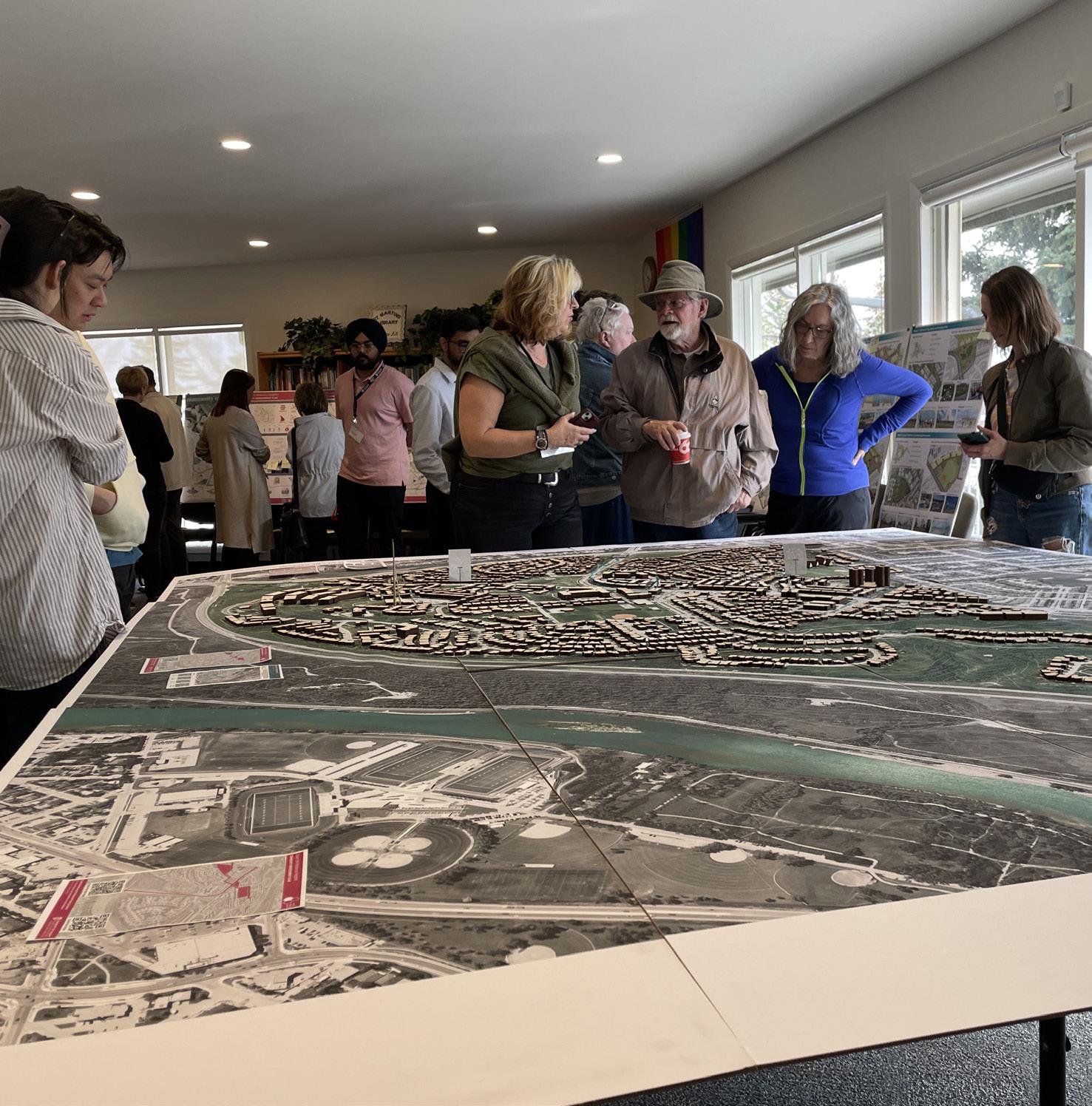
3.3 SITE MODEL
An 8’ by 10’ physical model of Coach Hill and Patterson Heights communities was built at a scale of 1:1000. The model was a collaborative effort of all ten students in the studio. An ortho aerial image was printed and attached to 10 MDF sheets as the model’s base. The buildings were made of Baltic Birch sheets lasercut and stacked on each other to indicate the approximate height of all buildings in the community. This model was revealed to the steering committee during the presentation of our draft concepts and made available for the public to engage and interact with during the final Open House.
On Saturday, April 13, 2024, our team and colleagues hosted a two-hour Open House at St. Martin’s Church in Coach Hill and Patterson Heights communities. Alongside the physical model, our team prepared five posters outlining our final design proposal and two mediums of interactive virtual reality. It was an open, informal feedback session where community members could interact with the displays and our team, asking questions and providing feedback. Our team documented this feedback and provided sticky notes for community members to leave comments. Feedback and comments were documented in a What We Heard Report and considered in our later phases.
“OBC is a barrier”
“more spaces for kids”
“the pathways are dark at night” “beautiful views”
WHAT WE HEARD AT THE OPEN HOUSE!
On Saturday, April 13, 2024, our team and colleagues hosted a two-hour Open House at St. Martin’s Church in Coach Hill and Patterson Heights communities. Alongside the physical model, our team prepared five posters outlining our final design proposal and two mediums of interactive virtual reality. It was an open, informal feedback session where community members could interact with the displays and our team, asking questions and providing feedback. Our team documented this feedback and provided sticky notes for community members to leave comments. Feedback and comments documented during the open house were included and considered during our final presentation to the steering committee and in compiling this report.
“The cafe at the park would be great!” “Density along OBC is good”
“Thank you for the intersection improvement ideas, they would help improve safety for children”
“Traffic implications on OBC rd?”
“Bike paths with buffers will be nice to have”
“Love the sign!”
“Commercial plaza definitely needs redevelopment
“I am nervous about the densification and all the traffic it will add”
“Commercial will also add traffic”
“Love the Main
Our team developed two types of virtual reality experiences for the public to engage with our intervention. We presented these experiences through a flyer distributed at the Open House. The first type consisted of three 360° images focusing on The Main Street + Prominence Park, The Commercial Node, Catwalks + Outdoor Rec Hub. Participants could interact with these images on their devices by scanning a QR code, allowing them to explore how these spaces could be transformed with our design interventions. The second type was a walkthrough video created through 3D modelling software and rendering tools, offering a human perspective experience of walking through our proposed Main Street, the Commercial Node, and the Catwalks forming the second half of our Main Corridor leading toward the Outdoor Rec Hub.
1) Prominence Park + Main Street
2) Commercial Node
360° Images of Nodes
3) Outdoor Rec Hub + Catwalk
Walkthrough
Open House Flyer
Walkthrough Video Stills Coach Hill Patterson Heights
As Third Places Studio, our vision for CHPH is to connect the two communities and create more social spaces where the residents can come together. We aim to do this by improving walkability, providing amenities, and improving the public realm to provide opportunities for more social connections.
Promote Walkability Diversify Amenities THIRD PLACES
Promote Social Connections Encourage Density
Improve the Public Realm
Following the analysis and initial community engagement sessions, our team outlined a series of interventions we call our Big Moves.
The first big move involves repairing the seam and improving Old Banff Coach Road to enhance pedestrian mobility and safety. This aims to enhance mobility and walkability throughout the community and eliminate the current physical and visual divide caused by the road.
The second big move is to connect three critical community nodes, which our team identified as Prominence Park, the Commercial Plaza, and the Outdoor Rec Hub. This will occur through establishing a vibrant Main Street and central corridor while establishing the idea of streets as shared spaces beyond just a means from A to B, as well as by concentrating public life within key central areas of the community. This Main Street will also lead into a redeveloped Coach Hill Plaza, which is re-imagined as a pedestrian-centric environment. This would provide social amenities and meet the daily needs of community members, ultimately completing the community and enhancing livability.
COACHROAD
SARCEETRAILSW
REPAIRING THE SEAM
Enhance Pedestrian Mobility and Safety on Old Banff Coach Road
CONNECTING THE COMMUNITY NODES
Establish Streets as Shared Spaces
Concentrate Public Life in Key Areas
Pedestrian Focused Development
Provide Social Amenities
Improving Walkability on OBC
Creating the Main Street
Rethinking the Commercial Node
EXISTING CONDITIONS
98% of the buildings within the community are residential There are unique housing types like the A-Frames, but the community is overall low-density
4.3 LAND USE + DENSITY
Coach Hill Plaza is the only commercial area in the community and lacks social amenities and things like a grocery store
Not all seniors can afford Prominence Way Retirement Community, and some community members want downsizing housing options
1) Promote gentle densification that maintains the existing character of the community to increase housing supply and options through land use changes
2) Prevent highway like conditions along OBC by increasing density and having new developments face the street to have an activated frontage and improved public realm
3) Integrate a mix of uses to support a Neighborhood Activity Centre to support a target intensity of 150 people+jobs/Ha
4) Concentrate density around the community nodes to support increased commercial activity
Proposed Land Use Changes
Although the community currently features a good variety of housing types, it is predominantly low-density. We propose land use changes around three key nodes to activate the public realm and increase social activity. The follow pages provide an overview of building types which could achieve this gentle densification across the community.
Through our proposed land use and density changes, we will have a communitywide increase in units and density of 1.85 times up to 18.7 units per hectare. Our proposed main street, along with the redeveloped commercial node, has the potential to become a Neighborhood Activity Center. With an area of 5.2 ha, it will create over 7000 sqm of commercial area and 135 jobs. The City of Calgary defines a Neighborhood Activity Centre (NAC) as a neighbourhood focal point featuring a blend of transit-supportive residential and non-residential uses. They are connected to nearby areas through a network of streets, walkways, and pathways and are designed to foster a positive pedestrian environment and an active public realm. Our team felt this is an appropriate scale and could be supported by Coach Hill and Patterson Heights communities with our proposed land use and density changes, which would help achieve our goals of completing the community.
Neighborhood Activity Centre
5.2
Community Wide
Building Type Recommendations
In the area concentrated with single detached dwellings around the outdoor activity hub, we recommend gentle densification through the addition of laneway homes and townhomes up to two stories, which will help maintaining the low-density character (see RC-G). Along Old Banff Coach Road, densification efforts will transform the highway-like conditions into a residential boulevard, with developments fronting the street to enhance the public realm and create a pleasant pedestrian environment, with residential buildings between three and four stories helping to keep the human-scale experience intact (see MC-2). Along our proposed Main Street, mixed-use buildings of up to five stories will support commercial uses at grade and help activate the street frontages (see MC-G and MU-2).
LANEWAY HOUSING
Laneway Houses, Vancouver Duplex Houses, Vancouver
These building types are suitable for in-fill densification in low-traffic residential areas. They have at-grade entry and can activate residential areas by having units with frontage on the street or back alley. They can be paired with a shared street condition. TOWNHOUSES
These types are suitable for roads with high traffic volumes and have frontage onto the street, to activate roads or park spaces. Rowhouses will have at-grade entry while apartment buildings will have a single common entry and could offer underground parking depending on their size.
This type has residential above and commercial at-grade, that spills out on the sidewalks activating the public realm. It will have underground parking. ROWHOUSES
Rowhouses, Calgary Apartment Buildings, California Mixed-Use Building, Calgary
EXISTING CONDITIONS
No designated bike paths on collector roads like Coach Hill Rd, people must bike on the streets
4.4 MOBILITY
Unsafe intersections are made worse by inadequate lighting, reduced visibility due to topography, and high vehicle speeds
Overgrown street trees along Coach Hill and tall streetlights contribute to lighting issues for sidewalks
Auto-centric design contributes to high vehicle speeds
1) Prioritize road and pathway upgrades to promote connectivity to the three community nodes and maximize benefit
2) Improve mobility options and provide physical separation for people walking, wheeling, and driving
3) Provide human scale lighting to encourage social activity and increase safety
4) Provide a toolkit of traffic calming and pedestrian safety measures that can improve intersections.
SARCEETRAILSW
One of the primary concerns raised within the community is the need for increased diversity in mobility options and enhanced pedestrian safety. In response, we have developed an active transportation toolkit designed to target specific community areas to provide the most significant overall benefit. A key area identified for this mobility investment is the loop along Coach Hill Rd and Patina Dr, which we have identified as the Active Transportation Network. This route has existing transit connections, feeds into Old Banff Coach Rd, and links much of the community to the three nodes. Implementing these improvements will significantly enhance the pedestrian experience and expand walking, wheeling, and public transit options, making the community more accessible and interconnected. Small pathway additions and enhancements are used to fill gaps and create a closed-loop network. This will work in conjunction with new bike paths along Old Banff Coach Road, which will now feed into the multi-use pathway network to the south of the community as you approach Bow Trail. Completion of the Active Transportation Network will be achieved by creating connectivity between the new designated bike paths and the pathway network. This will allow for a system that is both for travel and recreation purposes.
Pedestrian and Cyclist Priority
Accessibility
Linking the Community Nodes
Prioritizing pedestrians through traffic calming measures, providing physical separation between people driving, wheeling, and walking, and enhancing intersection safety and ease. Routes are made safe, accessible, and interconnected.
Enhancing accessibility through raised crosswalks and intersections to reduce grade changes, making navigation more accessible for all pedestrians. Widened sidewalks where possible to accommodate diverse users, alongside improved lighting and wayfinding.
Linking community assets by creating interconnected networks that connect residents to key destinations. This includes safely linking and prioritizing upgrades to collector roads that facilitate access.
Raised Crosswalk, New York, USA
Protected Bike Path, Selly Oak Road, Birmingham, England
Longfellow Street Residential Shared Street, Santa Monica, CA
Active Transportation Principles
We want to encourage multi-mode travel at all times through the retrofit of sidewalks, pathways, and intersections. A pedestrian infrastructure upgrade is proposed for the loop along Coach Hill Rd and Patina Dr. within the existing Right-Of-Way (ROW). To address areas where the existing road is narrower, we proposed multi-modal travel options that exclude on-street parking in certain areas.
The addition of safe and secure bike parking at all nodes will provide reliability and means for people to bike around the community and to these locations without worry.
Traffic Calming Toolkit
Adding human-scale lighting, such as low pathway lighting and highlow streetlights on streets, will help with lighting concerns and more direct light pathways and sidewalks, increasing use and safety while reducing light pollution to adjacent uses.
To help with connectivity and guide users to already great pathway networks across the community. A cohesive wayfinding strategy can also help with ease of use and community identity building.
We developed a toolkit of traffic calming measures to address problematic intersections in the community and increase safety and accessibility. These measures can be applied to various intersections and represent a range of costs and permanence.
$
Less Permanent
Curb Extension
Temporary Traffic Calming Curbs, Calgary, AB Curb Extension
Concrete Curb Extension, Montreal, QC
Raised Crosswalk
Raised Crosswalk, Chicago, IL
Painted Crosswalk
Colored Crosswalks, Baltimore, USA
Raised Intersection
Raised Intersection, Cambridge, MA
EXISTING CONDITIONS
Old Banff Coach Road as a physical and visual barrier that divides the two communities
4.5 REPAIRING THE SEAM
Unsafe Intersections with no pedestrian crossing lights at Patterson Hill and Coach Hill Dr intersection
Portions of Old Banff Coach Rd lacks sidewalks, and there are no designated bike paths, which limits multi-modal movement
Entrance into CHPH off of Bow Trail lacks visual indication that you are entering the community
Old Banff Coach Road Improvements Map
1) Eliminate turning lanes along Old Banff Coach Road to reduce vehicle speeds
2) Add bike paths, sidewalks, and vegetation on Old Banff Coach Road to improve pedestrian experience
3) Improve intersections through the removal of slip lanes, and addition raised crosswalks and pedestrian crossing lights where missing
4) Build a community welcome sign at the entrance of Old Banff Coach Road to establish a community identity
COACHROAD
SARCEETRAILSW
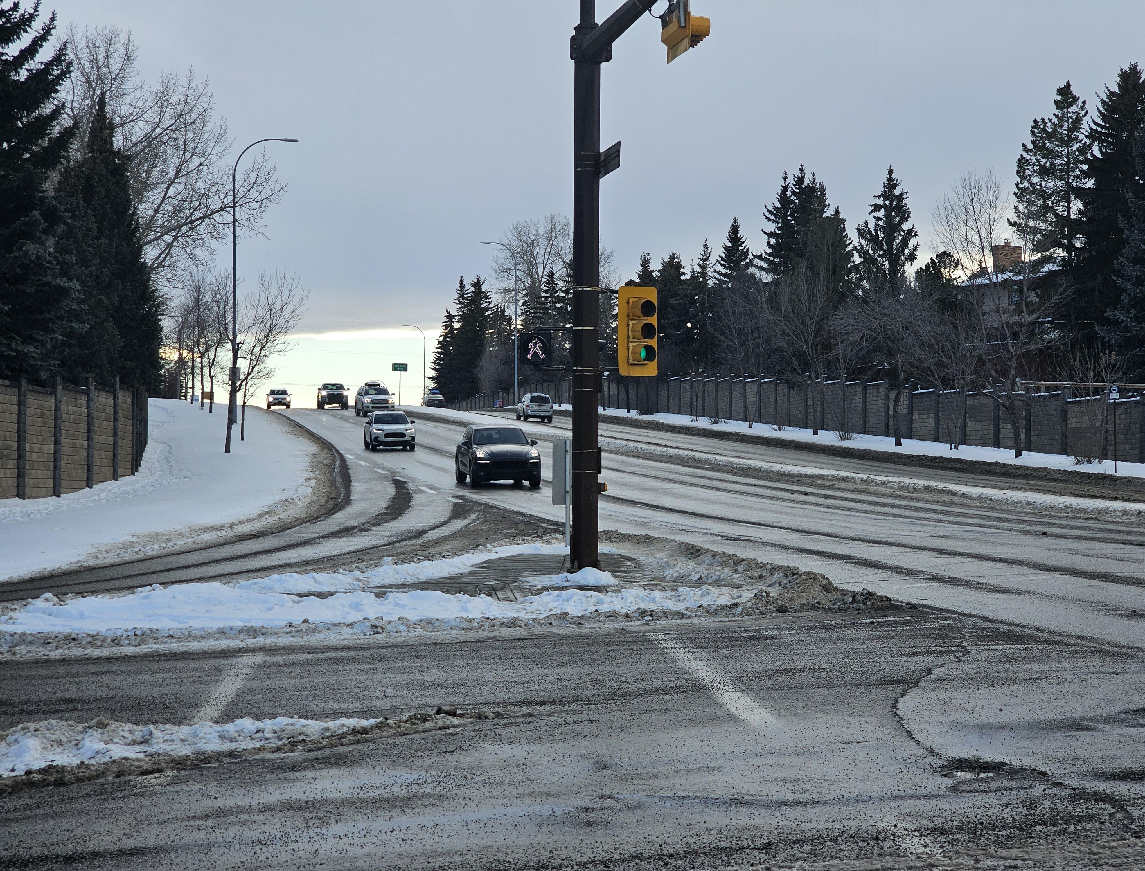
Our first big move is repairing the seam by improving pedestrian mobility and safety along Old Banff Coach Road, which currently acts as a barrier between the two communities and inhibits a pedestrian’s ability to cross it. The lack of crossing signals, sidewalks, bike lanes, and dark sidewalks and intersections hinders pedestrian mobility along Old Banff Coach Road, deterring community members from walking even short distances. Our strategies include eliminating turning lanes along OBC and extending into West Springs to reduce vehicle speeds. We propose enhancing the entire stretch of Old Banff Coach Road with bike paths, continuous sidewalks, vegetation, and high-low streetlights. Pedestrian paths to the south will connect to the multi-use pathway system. At the same time, we recommend that improvements to the north should extend west towards Stoney Trail, creating a safer, more accessible environment for all.
To address the lack of identity and legibility of entering the community. We propose to build a community welcome sign at the entrance of OBC from Bow Trail, which will work to establish a community identity and provide a visual indication that you are entering the community. Although there is not as much space on the north entrance of the community, a similar type of signage or wayfinding could occur at a smaller scale within the tree buffer zone along Old Banff Coach Road.
Existing
Proposed Community Entrance
Typical Old Banff Coach Road Sections
Two different conditions will occur along the Old Banff Coach Road interface. The gradual built form density increase from the community entrance to further inside. This will change the experience of driving into the community and help slow down traffic.
Human-Scale Lighting
Multi-Use Pathway Connection
High-Low Street Lights, Beijing
Multi-Use Pathway, Central Valley Greenway, Vancouver, BC
Old Banff Coach Road Section A
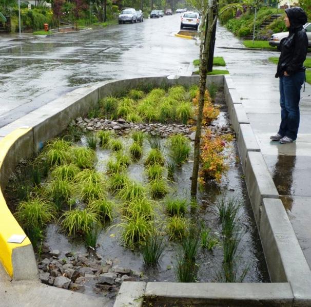
Bioswales, Vancouver
Stormwater Management
Paseo de La Reforma, Mexico City
Creating a Residential Boulevard
Old Banff Coach Road Section B
Proposed Improvements on Old Banff Coach Road with the Interface of the Dog Park
Intersection Improvements
OLD BANFF COACH ROAD
Intersection improvements were also a large part of improving the experience of walking along and crossing Old Banff Coach Road. Tactics include slowing down traffic turning at the intersections by removing the slip lanes, adding raised crosswalks to improve accessibility, and installing pedestrian crossing lights where they are missing.
Intersection Improvement C Intersection Improvement D Intersection Improvement E
Bioswale, Los Angeles
COACHOLDBANFF RD PATTERSONBLVD
EXISTING CONDITIONS
Disconnected sidewalks and unsafe intersections on the intersection of Patina Dr, which has public transit and a school bus drop-off
4.6 CONNECTING THE NODES
NODE 1 PROMINENCE PARK
Prominence Park is missing sidewalks along part of its perimeter and does not have a strongly defined edge which draws one into the space
The community lacks commercial uses beyond Coach Hill Plaza and could additional social spaces/ amenities
The former CHPH Community Association Building was vacated in 2005 and has been chronically underutilized since
Commercial Uses Underutilized Former CHPH CA Building Disconnected Sidewalks + Unsafe Intersections Inactive Park Edge
1) Create a Main Street with commercial frontage to activate the public realm and provide access to amenities and social spaces
2) Reduce lane widths to provide additional space for walking and wheeling
Connecting the Nodes - Main Street + Prominence Park
NODE 1 Strategies
3) Activate the edge of Prominence Park through the creation of a cafe + event space
4) Define the park edges and improve accessibility through sidewalk and intersection improvements
BANFF COACHROAD
SARCEETRAILSW
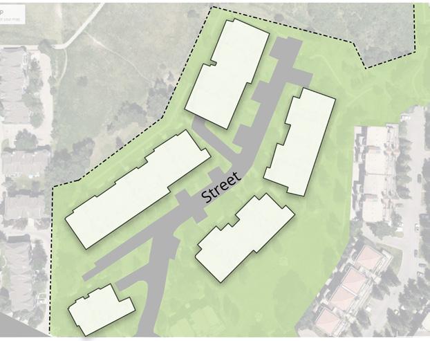
The second Big Move aims to improve and connect the three community nodes. The first node is Prominence Park, which will be redeveloped alongside the creation of our Main Street. This Main Street will begin by redeveloping a portion of Patterson Boulevard to include mixed-use buildings, activating the public realm and providing access to additional amenities and social spaces centrally within the community. This new main street will reduce the number of vehicle lanes and reallocate space for bike lanes and larger continuous sidewalks that will extend around the entire park. We see this not only as an opportunity to increase accessibility for both the street and the park but also to activate the park’s edge and draw people into the park off Main Street. The park will be further activated and anchored on the main street by redeveloping the underutilized former Community Association building. We imagine this as a cafe and event space that spills into the corner entrance plaza, which can also be used for food trucks. Many community members expressed lots of love for existing park programming, including the playground and events like the Calgary EATS food stand and movies in the park. Interventions within the park aim to enhance what already exists by adding accessible pathways, revitalizing the abandoned ice rink, and activating the park with additional all-year park programming and opportunities for exercise, play, informal gatherings, and events.
The Main Street refers to our central corridor that bridges both communities. It serves as the heart of the community, distinguished by its vibrant mix of amenities and uses. It combines residential and commercial spaces, creating a dynamic and integrated urban environment. To break the monotony across its entire length, Main Street has three different conditions. First, it interfaces directly with the Prominence Park; second, near the Commercial Node, we have the double frontage experience; and lastly, it becomes the pedestrian extension leading toward the Outdoor Rec Hub. All of this contributes to a dynamic experience moving through the entirety of the central corridor and enriches Main Street’s recreational, social, and economic vitality. The design includes dedicated bike paths and wide pedestrian sidewalks to promote multi-modal transportation and social interaction, making the Main Street a hub of activity and connectivity.
PATINA DR
Micro Community Park, Songzhuang, China
Cesar Chavez Park, Denver, Colorado
Julia Reserve Youth Park, Oran Park, Australia
Coffee House in Park Hurbanovesady, Slovakia
Typical Main Street Section A
PATTERSONMEWS
Protected bike paths exist on Prominence Park's north and west perimeters, connecting to the rest of the Active Transportation Network.
Raised Intersections reinforce slower vehicle speeds, encouraging vehicles to yield to crossing pedestrians. They also help with accessibility, as they remove the curb cut.
Bus Bulb extends the sidewalks into the parking lanes to narrow the roadway, slowing down nearby vehicles and increasing pedestrian safety. It also provides additional space around the existing bus stop and allows buses to make in-lane stops.
Colored Crosswalks are a tactical way to enhance intersections and make them safer for pedestrians. They could also celebrate the community's identity through art.
PATINA DRIVE
Protected Bike Lane, Portland, USA
Bus Bulbs, NACTO
Colored Crosswalks, Baltimore, USA
Raised Intersection, Seattle, WA
4.7 CONNECTING THE NODES
4.7 CONNECTING THE NODES - THE COMMERCIAL NODE
Strategies
1) Establish the commercial node as the main street anchor off Old Banff Coach Road
2) Ensure that new mixed-use buildings face the street to create and active frontage along the main street
3) Increase amenities for daily needs and socialization in the commercial node
4) Redesign the gas station as a people-centric mobility hub
Connecting the Nodes - Commercial Node
COACHROAD
SARCEETRAILSW
We aim to transform the outdated Coach Hill plaza into a dynamic, mixeduse hub that enhances community life. This redevelopment plan emphasizes pedestrian-only plaza spaces and vibrant building frontages along the Main Street, aligning with the natural sun path and site topography to maximize sunlight exposure. The innovative design integrates residential and commercial spaces, fostering activity and vibrancy within the community.
Site Analysis
Existing Sections of the Coach Hill Plaza
OLDBANFFCOACHRD
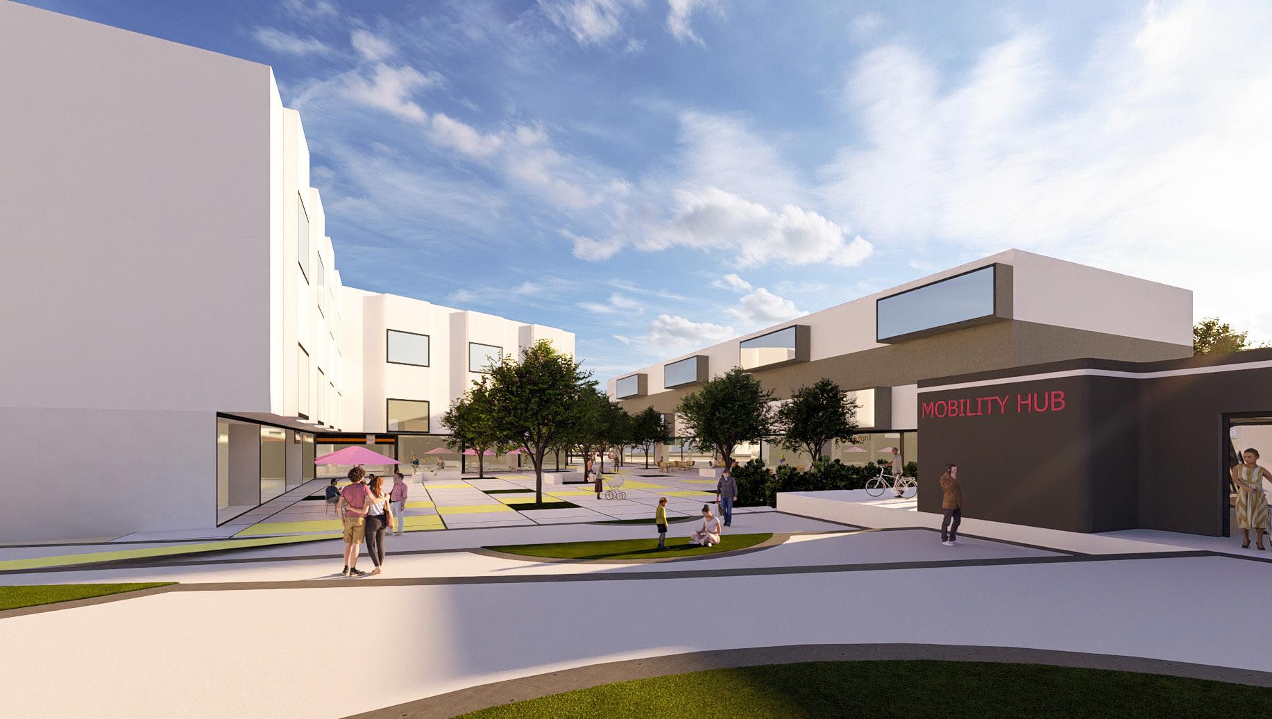
We propose re-imagining the existing gas station as a modern mobility hub. This enhanced facility will maintain its original services while incorporating additional features such as bike storage and repair stations, and electric vehicle charging points. This transformation aims to support and encourage diverse transportation options within the community.
The challenging topography of the commercial node complicates the current parking arrangements, the comfort of the public spaces, and the overall appeal of the site. To address these issues, the proposal involves adapting to the topography by incorporating an underground parking lot, which will allow the plaza to be free of cars and enhance the public realm. The solution to the topography challenges is detailed in the section and site renders below.
Suburban
Mobility Hub
The Concept of People-Centric Mobility Hub
Public Plaza
Commercial Node Section A
4.8 CONNECTING THE NODES
NODE 3
OUTDOOR RECREATION HUB
The Outdoor Recreation Hub in Coach Hill as an inactive park edge which has an interface with an alley where there’s little to no foot traffic, amenities, or recreational facilities.
Poor lighting inside and along the park edge causes safety concerns
Particularly in Coach Hill, most residential areas have high fences that contribute to an impermeable public realm
Barriers cause poor accessibility on pedestrian connections
Connecting the Nodes - Outdoor Rec Hub
1) Establish a pedestrian connection off the Main Street towards the Outdoor Rec Hub by activating existing alleys and pathway systems
2) Increase density around the park to activate the edges
3) Create shared streets that can meet the desires of adjacent residents and function foremost as a public space for recreation, socialization, and leisure
4) Create accessible entryways into the park Strategies
OLD BANFF
COACHROAD
SARCEETRAILSW
Our final big move aims to improve pedestrian access across all three nodes, i.e. Prominence Park, the Commercial Plaza and the Outdoor Recreation Hub. The revitalization of the main street and its intersection with OBC Road presents an opportunity to extend community connectivity and create a vibrant pedestrian network. Central to this vision is activating existing pathways, particularly alleyways and catwalks, which serve as vital shortcuts to the community’s outdoor recreation hub. Building upon successful precedents of alley activations where community-led interventions have redefined public spaces, our approach prioritizes inclusivity and community ownership. Through collaborative efforts, we seek to create environments that inculcate a sense of belonging and facilitate increased social cohesion.
Furthermore, our proposal aims to retain the programming for the outdoor rec hub. Still, we see an opportunity to reconfigure the spaces and add additional functions like a dog park and outdoor fitness park. By reconfiguring existing spaces and optimizing pedestrian routes, we aim to create a desirable destination that caters to diverse recreational interests while promoting active lifestyles. The alleyway connecting the catwalks is envisaged as a shared street, promoting inclusivity and accessibility for individuals of all ages and abilities. This thoughtful design approach extends to creating an entry plaza within the park, seamlessly integrating with an accessible pathway that encircles the park’s interior.
NODE 3
The existing alleyway which connects the catwalks is envisioned as a shared street. The catwalks seen here create an opportunity to define an entry plaza within the park and connect to an accessible pathway that loops within the park. This ensures that people of all ages and abilities can use these spaces. As mentioned in the land use section, this area around the park has the potential to be v with laneway housing and secondary suites. So, the frontages onto the alleyway also support the shared street concept and help activate the park edges. Shared streets can meet the desires of adjacent residents and function foremost as a public space for recreation, socializing, and leisure.
By leveraging existing infrastructure and harnessing community engagement, we aspire to create a holistic pedestrian network that enhances mobility and enriches the quality of life for all residents. These systems would work together to create a comprehensive pedestrian network that completes the central corridor of the main street and provides more opportunities to connect the community.
Precedents
Catwalks or engineered walkways help to facilitate movement between homes, schools, and parks within communities. Unfortunately, neglect has led residents to avoid these routes despite their potential benefits. Inspired by Sustainable Calgary’s Reimagine Catwalks Playbook, we have identified three catwalks in Coach Hill Patterson Heights close to the Outdoor Recreation Hub and propose revitalizing these pathways to foster active, connected, and productive community spaces. Emphasizing pedestrian-friendly design, it advocates for safe, comfortable, and engaging environments that cater to diverse users, including wheelchair users, parents with strollers, and children. Well-connected communities foster inclusivity, ensuring all residents can access essential services and amenities without reliance on cars. Catwalks can encourage active lifestyles by promoting walkability and enhancing pathways while reducing greenhouse gas emissions from vehicular traffic. These efforts align with the City of Calgary’s established policies like the 5A Network Guiding Principles, prioritizing year-round safe and affordable travel options. Additionally, communities can seek funding through ActivateYYC grants to implement improvements to their catwalks.
Catwalk Ideas - Sustainable Calgary
Section A - Shared Street + Outdoor Rec Hub
Catwalk + Alley Activation
Entrance Plaza + Shared Street
5. POLICIES
Land Use and Density
Policy 1: For new developments along Old Banff Coach Road, the new buildings should front the road to promote a welcoming street environment. Keeping building heights to a maximum of 18 meters or five storeys will help maintain the area’s existing character and scale.
Policy 2: In areas adjacent to outdoor recreation hubs, more dense housing should be implemented, with a maximum of 4 units per lot and building heights restricted to 2 storeys or 8 meters.
Policy 3: Parcels with laneway access should be encouraged to develop secondary suites and laneway housing. These units can offer flexible and cost-effective living options. The secondary suites should have frontage on the laneway to support the shared street concept.
Policy 4: For the redevelopment of the commercial hub and main street proposal, mixed-use development should be implemented with active frontages and support a target intensity of at least 150 People + Jobs/ ha.
Policy 5: The new density should be concentrated around community nodes, such as a commercial area, outdoor rec hub, and prominence park, to support the proposed amenities.
Policy 1: Evaluate the current conditions of roads and pathways to identify crucial areas within the community that need enhancements.
Policy 2: Introduce dedicated lanes for pedestrians, cyclists, vegetation, bioswales and vehicles, with distinct physical separations and protections to ensure safety and efficiency where feasible.
Policy 3: In areas with narrow right-of-ways and laneways, consider adopting shared street zones that safely accommodate pedestrians, cyclists, and low-speed vehicles.
Policy 4: Enhance pathway visibility for pedestrians and cyclists by introducing human-scale lighting, including high-low streetlights.
Policy 5: Create a traffic calming toolkit containing temporary and permanent measures, such as raised intersections, raised crosswalks, and removing slip lanes.
Policy 6: Collaborate with interested parties to systematically upgrade infrastructure and implement diverse traffic calming strategies to improve safety.
Policy 7: By adding density, pedestrian pathways, and bike paths on Old Banff Coach Road, removing all turning lanes will slow down traffic and create a safer, more pleasant experience for pedestrians and cyclists.
Policy 8: Collaborate with local artists, designers, and community members through workshops and design charettes to create a sign that reflects the community’s unique character and heritage and put it at the community’s entrance.
Nodes
Policy 1: Implement design guidelines that require main-floor commercial spaces in all mixed-use buildings facing the street frontage to create an Active Street frontage.
Policy 2: Encourage designs incorporating transparent windows, outdoor seating patios, and pedestrian-friendly access to enhance street-level activity.
Policy 3: Encourage the development of a mix of services and facilities such as cafes, shops, public plazas, and community centres in the commercial node.
Policy 4: Redesign the existing gas station in the community into a multifunctional mobility hub that enhances its usability by including features like bike storage and repair and electric vehicle charging stations.
Policy 5: Promote the commercial node as the central anchor of Coach Hill and Patterson Heights, enhancing its role as a lively and bustling main street.
Policy 6: Activate and develop the edge of Prominence Park by introducing a café and multifunctional event space to attract visitors and host community gatherings.
Policy 7: Promote and implement design elements that blend the new facilities with the park’s natural environment to maintain aesthetic harmony.
Policy 8: Identify and upgrade underutilized alleys and pathways with improved lighting, signage, and landscaping to create a safe and inviting pedestrian lane, also known as catwalks.
Policy 9: Upgrade all park entrances with ramps, tactile paving, and clear signage to accommodate users of all abilities, including those with mobility impairments.
Policy 10: Enhance park entrances’ visual appeal and functionality with landscaping, art installations, and seating areas to draw visitors into the park and create a smooth transition from urban to green spaces.
6. CONCLUSION
Our implementation strategy for the project at Coach Hill and Patterson Heights is structured around three key phases: short-term, medium-term, and long-term. In the short term, we will focus on cost-effective initiatives such as activating catwalks and alleys, enhancing wayfinding, and developing a traffic-calming toolkit. For the medium term, our goals include starting the development of the commercial node, enhancing local parks, and rolling out the Active Transportation Network. Finally, our long-term objectives are centered on upgrading Old Banff Coach Road, promoting gentle densification, and executing the rezoning, improvements, and full build out of Main Street.
In conclusion, our comprehensive design proposal for Coach Hill and Patterson Heights aims to foster a connected, vibrant, and livable community. Our strategic interventions, namely repairing the seam along Old Banff Coach Road, connecting the three key nodes, and introducing thoughtful densification and land use changes, are designed to enhance the quality of life for all residents.
Our efforts to improve mobility, with a focus on pedestrian and cyclist priority, accessibility, and multi-modal travel options, underscore our commitment to sustainable urban living. The introduction of new social spaces, increased housing options, and enhanced public amenities reflect our dedication to creating spaces that promote community interaction and engagement.
Through these transformations, we envision Coach Hill and Patterson Heights not just as two separate communities, but as a cohesive unit with a strong sense of identity and inclusivity. Our proposed changes aim to ensure that both communities thrive as a unified, dynamic environment where social, economic, and environmental sustainability are balanced.
We look forward to the continued feedback from the steering committee and are excited about the potential to move forward into the implementation phase. Thank you for the opportunity to contribute to the future of Coach Hill and Patterson Heights.
REFERENCES
Waseem, F., 7, B. A. H., & Solutions, B. P. M. (2022, March 25). Readelston Association pushes for VDOT to redesign ‘pork chop’ road island. FFXnow. Retrieved from https://www.ffxnow.com/2022/03/25/reston-associationpushes-for-vdot-to-redesign-pork-choproad-island/
Site Design Group Ltd. (n.d.). Mary Bartelme Park | Urban Park Design in Chicago. Retrieved 2024, from https://www.site-design. com/projects/urban-park-design-chicago/
StudioCPG. (n.d.). Cesar Chavez Park. Retrieved 2024, from https://studiocpg.com/projects/parks-trails-open-space/cesar-chavezpark/
Chan, A. (2021, May 11). Langford building new community hub to fight ‘general decline’ of Station Avenue area. CTV News Vancouver Island. Retrieved 2024, from https://vancouverisland.ctvnews.ca/langford-building-new-community-hub-to-fight-general-declineof-station-avenue-area-1.5423053
WeatherStats. (n.d.). Calgary yearly snow statistics. Retrieved 2024, from https://calgary.weatherstats.ca/charts/snow-yearly.html
City of Calgary. (n.d.). Sanding and plowing priorities. Retrieved 2024, from https://www.calgary.ca/roads/conditions/sandingplowing-priorities.html
City of Calgary. (n.d.). Pathways and bikeways map. Retrieved 2024, from https://maps.calgary.ca/PathwaysandBikeways/
Calgary Real Estate Board. (2018, June). 50 shades of green. Retrieved 2024, from https://www.creb.com/News/CREBNow/2018/ June/50_shades_of_green/
Park People. (2021). Calgary city profile. Retrieved 2024, from https://ccpr.parkpeople.ca/2021/cities/calgary
City of Calgary. (n.d.). Play space optimization. Retrieved 2024, from https://engage.calgary.ca/playspaceoptimization#:~:text=For%20all%20areas%20of%20the,for%201%2C000%20kids%20under%2012.
City of Calgary. (n.d.). Parks plan. Retrieved 2024, from https://engage.calgary.ca/parksplan
Coach Hill Patterson Heights Community Association. (n.d.). Development. Retrieved 2024, from https://www.chph.ca/ development
Coach Hill Patterson Heights Community Association. (n.d.). Schools. Retrieved 2024, from https://www.chph.ca/schools
Coach Hill Patterson Heights Community Association. (n.d.). Parks and recreation. Retrieved 2024, from https://www.chph.ca/ parks-recreation
Coach Hill Patterson Heights Community Association. (n.d.). Little free libraries. Retrieved 2024, from https://www.chph.ca/littlefree-libraries
Coach Hill Patterson Heights Community Association. (n.d.). Amenities and services. Retrieved 2024, from https://www.chph.ca/ amenities-services
Coach Hill Patterson Heights Community Association. (n.d.). Produce stand. Retrieved 2024, from https://www.chph.ca/post/ produce-stand
Prominence Way Retirement. (n.d.). Homepage. Retrieved 2024, from https://www.prominencewayretirement.com/
National Association of City Transportation Officials. (n.d.). Boulevard. Retrieved 2024, from https://nacto.org/publication/urbanstreet-design-guide/streets/boulevard/
National Association of City Transportation Officials. (n.d.). Residential boulevard. Retrieved 2024, from https://nacto.org/ publication/urban-street-design-guide/streets/residential-boulevard/ City of Calgary. (n.d.). Public document stream. Retrieved 2024, from https://pub-calgary.escribemeetings.com/filestream. ashx?DocumentId=25361
Sustainable Calgary. (2020, November 18). Neighbourhood active transportation networks. Retrieved 2024, from https://www. sustainablecalgary.org/publications-1/2020/11/18/neighbourhood-active-transportation-networks
Sustainable Calgary. (2020, November 17). NATN sustainable Calgary 2020 report [PDF]. Retrieved 2024, from https://static1. squarespace.com/static/5ab716b9ee1759b04ca2703e/t/5fb60bb1b5b9ff47dcf16d02/1605766099671/NATN_Sustainable_ Calgary_2020_Nov_17_20MB.pdf
CHPH Community profile. CHPH. (2024a). https://www.chph.ca/community-profile
CHPH Home. CHPH. (2024b). https://www.chph.ca/
Rondeau, A. (2024). Park in Patterson. CHPH. Retrieved 2024, from https://www.chph.ca/community-profile?pgid=kmv9zmoqc02f41cd-3d05-41aa-aab4-f04cef47defa.
City of Calgary. (n.d.). Coach Hill community profile. Retrieved 2024, from https://www.calgary.ca/communities/profiles/coach-hill. html
City of Calgary. (n.d.). Patterson community profile. Retrieved 2024, from https://www.calgary.ca/communities/profiles/patterson. html
City of Calgary. (n.d.). 9 Ave streetscape. Retrieved 2024, from https://engage.calgary.ca/9AveStreetscape
CEPT University. (2023). Elements of urban design - Spring 2023. Retrieved 2024, from https://portfolio.cept.ac.in/2023/S/fp/unit-3ud4003-3-spring-2023/elements-of-urban-design-spring-2023-pud22299
Inkspire. (n.d.). Revitalizing Toronto’s untapped laneways as public spaces. Retrieved 2024, from https://inkspire.org/post/ revitalizing-torontos-untapped-laneways-as-public-spaces/
Studio Binocular. (n.d.). Adelaide. Retrieved 2024, from https://www.studiobinocular.com/projects/adelaide/
City of Edmonton. (n.d.). Active transportation network improvements project. Retrieved 2024, from https://www.edmonton.ca/ projects_plans/roads/active-transportation-network-improvements-project
City of Calgary. (n.d.). Pathway and bikeway plan. Retrieved 2024, from https://www.calgary.ca/planning/transportation/pathwaybikeway-plan.html
University District. (n.d.). Homepage. Retrieved 2024, from https://myuniversitydistrict.ca/
CivicWorks. (n.d.). West District. Retrieved 2024, from https://www.civicworks.ca/west-district
Studio CPG. (n.d.). Cesar Chavez Park. Retrieved 2024, from https://studiocpg.com/projects/parks-trails-open-space/cesar-chavezpark/
Stantec. (n.d.). Redefining lost urban spaces: 5 ways to turn a laneway into a ‘lanescape’. Retrieved 2024, from https://www.stantec. com/en/ideas/topic/cities/redefining-lost-urban-spaces-5-ways-to-turn-a-laneway-into-a-lanescape
Vancouver Is Awesome. (n.d.). Laneway living room: Unusual alleyway activations breathe life into unused public space. Retrieved 2024, from https://www.vancouverisawesome.com/courier-archive/news/laneway-living-room-unusual-alleyway-activationsbreathe-life-into-unused-public-space-3056837
Trends Ideas. (n.d.). How pocket parks can make a big impact on urban living. Retrieved 2024, from https://trendsideas.com/stories/ how-pocket-parks-can-make-a-big-impact-on-urban-living
Ecological Design Lab. (2017). The Final MRP Digital Copy. Retrieved 2024, from https://ecologicaldesignlab.ca/site/ uploads/2017/03/TheFinalMRP4.12DigitalCopy.pdf
City of Yarra. (n.d.). Charles Evans Reserve - Draft Concept Design. Retrieved 2024, from https://hdp-au-prod-app-yrra-yoursay-files. s3.ap-southeast-2.amazonaws.com/5517/0787/7003/Charles_Evans_Reserve_-_Draft_Concept_Design.pdf
Skalgubbar. (n.d.). Retrieved 2024, from https://skalgubbar.se/
The Noun Project. (n.d.). Retrieved 2024, from https://thenounproject.com/
City of Edmonton. (n.d.). Active Transportation Network Improvements Project. Retrieved 2024, from https://www.edmonton.ca/ projects_plans/roads/active-transportation-network-improvements-project
City of Calgary. (n.d.). DMAP Calgary. Retrieved 2024, from https://dmap.calgary.ca/
City of Calgary. (n.d.). Active Transportation Network. Retrieved 2024, from https://www.lookforwardcalgary.org/active_ transportation_network
City of Calgary. (n.d.). Pathway and Bikeway Plan. Retrieved 2024, from https://www.calgary.ca/planning/transportation/pathwaybikeway-plan.html
Sustainable Calgary. (2020). Neighbourhood Active Transportation Networks. Retrieved 2024, from https://www.sustainablecalgary. org/publications-1/2020/11/18/neighbourhood-active-transportation-networks
City of Calgary. (n.d.). School Enrollment Data. Retrieved 2024, from https://data.calgary.ca/Demographics/School-EnrolmentData/9qye-mibh/data
City of Calgary. (n.d.). Pathway and Bikeway Plan. Retrieved 2024, from https://www.calgary.ca/planning/transportation/pathwaybikeway-plan.html
ArchDaily. (2021). Songzhuang Micro-Community Park / Crossboundaries. Retrieved 2024, from https://www.archdaily. com/967372/songzhuang-micro-community-park-crossboundaries/61258c95f91c81a1670000c1-songzhuang-micro-communitypark-crossboundaries-image
Archello. (n.d.). Photos & videos. Retrieved 2024, from https://archello.com/story/61232/attachments/photos-videos/4
Carra, G. (2023). Forest Lawn Park redevelopment. Retrieved 2024, from https://www.gccarra.ca/ward-9-communityupdates/2023/4/forest-lawn-park-redevelopment
Urban Toronto. (2023). Five designs shortlisted for Entertainment District public park. Retrieved 2024, from https://urbantoronto.ca/ news/2023/10/five-designs-shortlisted-entertainment-district-public-park.54132
CTV News Vancouver Island. (2021). Langford building new community hub to fight general decline of Station Avenue area. Retrieved 2024, from https://vancouverisland.ctvnews.ca/langford-building-new-community-hub-to-fight-general-decline-of-stationavenue-area-1.5423053
City of Calgary. (n.d.). Calgary imagery. Retrieved 2024, from https://maps.calgary.ca/CalgaryImagery/
City of Calgary. (n.d.). Data Calgary. Retrieved 2024, from https://data.calgary.ca/
City of Calgary. (n.d.). Land use planning & policy. Retrieved, 2024, from https://www.calgary.ca/planning/land-use.html
National Association of City Transportation Officials. (n.d.). Residential shared street. Retrieved 2024, from https://nacto.org/ publication/urban-street-design-guide/streets/residential-shared-street/
Bellefleur, O. (n.d.). Traffic calming measures. Retrieved 2024, from https://nacto.org/docs/usdg/traffic_calming_measures_ bellefleur.pdf
ActivateYYC. (2019). Playbook June 18 [compressed]. Retrieved April 20, 2024, from https://activateyyc.calgarycommunities.com/ wp-content/uploads/sites/3/2019/06/Playbook-June-18-compressed.pdf
National Association of City Transportation Officials (NACTO). (n.d.). NACTO. Retrieved 2024, from https://nacto.org/
National Association of City Transportation Officials (NACTO). (n.d.). Bus Bulbs. In Urban Street Design Guide. Retrieve, 2024, from https://nacto.org/publication/urban-street-design-guide/street-design-elements/curb-extensions/bus-bulbs/
National Association of City Transportation Officials (NACTO). (n.d.). Raised Intersections. In Urban Street Design Guide. Retrieved 2024, from https://nacto.org/publication/urban-street-design-guide/intersections/minor-intersections/raised-intersections/
National Association of City Transportation Officials (NACTO). (n.d.). Speed Reduction Mechanisms. In Urban Street Design Guide. Retrieved 2024, from https://nacto.org/publication/urban-street-design-guide/design-controls/design-speed/speed-reductionmechanisms/ McPhillips. (n.d.). Selly Oak New Road Phase 1B, Birmingham. Retrieved 2024, from https://www.mcphillips.co.uk/projects/selly-oaknew-road-phase-1b-birmingham/
NYC Street Design Manual. (n.d.). Raised Crosswalk. Retrieved 2024, from https://www.nycstreetdesign.info/geometry/raisedcrosswalk
Streetlife. (n.d.). Rough&Ready Bike Parking. Retrieved 2024, from https://www.streetlife.nl/en/products/roughready-bike-parking
City of Calgary. (n.d.). City’s Traffic Calming Curbs Win Canadian Award for Road Safety Engineering. Retrieved April 2024, from https:// newsroom.calgary.ca/citys-traffic-calming-curbs-win-canadian-award-for-road-safety-engineering/
City of Montreal. (n.d.). Curb Extensions: Crossing the Street Safely. Retrieved April 2024, from https://montreal.ca/en/articles/curbextensions-crossing-street-safely-14429
Participatory Budgeting Cambridge. (n.d.). Raised Intersections. Retrieved April 2024, from https://pb.cambridgema.gov/pb8_ raisedintersections
Graham Projects. (n.d.). Reverberations Crosswalk. Retrieved April 2024, from https://grahamprojects.com/projects/reverberationscrosswalk/
YaoLong Poles. (n.d.). Round Tapered High and Low Arm Spinning Aluminum Alloy Street Light Pole. Retrieved 2024, from https:// www.yaolongpole.com/round-tapered-high-and-low-arm-spinning-aluminum-alloy-street-light-pole.html
TransLink Buzzer Blog. (2009, June 15). A Tour of the Central Valley Greenway, a Major New Bike and Walking Path Through Three Municipalities. Retrieved 2024, from https://buzzer.translink.ca/index.php/2009/06/a-tour-of-the-central-valley-greenway-amajor-new-bike-and-walking-path-through-three-municipalities/
City of Portland. (n.d.). How We Manage Stormwater. Retrieved 2024, from https://www.portland.gov/bes/stormwater/how-wemanage-stormwater
Global Designing Cities Initiative. (n.d.). Sidewalk Extensions. In Global Street Design Guide. Retrieved April 2024, from https:// globaldesigningcities.org/publication/global-street-design-guide/designing-streets-people/designing-for-pedestrians/sidewalkextensions/
Landezine. (n.d.). Julia Reserve Youth Park by JMD Design. Retrieved April 2024, from https://landezine.com/julia-reserve-youthpark-by-jmd-design/
Landezine. (n.d.). Culver Steps and Main Plaza by SWA Group. Retrieved April 2024, from https://landezine.com/culver-steps-andmain-plaza-by-swa-group/
Vulog. (n.d.). What Are Mobility Hubs and Why They Are the Future of Gas Stations. Retrieved April 2024, from https://www.vulog. com/blog/what-are-mobility-hubs-and-why-they-are-the-future-of-gas-stations/
CoMoUK. (n.d.). The Design Process - Mobility Hubs Realised. Retrieved April 2024, from https://assets-global.website-files. com/6102564995f71c83fba14d54/630f763354842c66afddb22c_CoMoUK%20The%20design%20process%20-%20mobility%20 hubs%20realised.pdf
Demain la Ville. (n.d.). Soigner la Ville: L’Acupuncture Urbaine. Retrieved April 2024, from https://www.demainlaville.com/soignerville-lacupuncture-urbaine/
ArchDaily. (n.d.). Wal-l-tz Installation / T Sakhi Architects. Retrieved April 2024, from https://www.archdaily.com/928497/wal-l-tzinstallation-t-sakhi-architects
City of Chicago. (n.d.). Pedestrian Infrastructure Field Guide. Retrieved April 2024, from https://www.chicago.gov/city/en/sites/ complete-streets-chicago/home/pedestrian-program/pedestrian-infrastructure-field-guide.html
All the GIS data was provided by SANDS, University of Calgary and City of Calgary open data Site images were retrieved from Google Earth