Expedition
Temple
3-7
London
+44 (0)20
www.expedition.uk.com
info@expedition.uk.com

Expedition
Temple
3-7
London
+44 (0)20
www.expedition.uk.com
info@expedition.uk.com
Appendix
This River Impact Assessment has been prepared to support the Hybrid Planning Application for the comprehensive, phased redevelopment of land at Lewisham Shopping Centre and adjacent land. It considers and seeks to mitigate any impact of the proposed development onto the nearby River Ravensbourne and River Quaggy.
This document is organised as follows:
• Section 2 describes the development site;
• Section 3 summarises key relevant policy;
• Section 4 describes the river system and its baseline condition;
• Section 5 summarises the development proposals;
• Section 6 assesses the potential impact of the development considering overshadowing, flood risk, water and ecological quality and discusses improvement of amenity access and connectivity of green spaces; and,
• Section 7 concludes.
The planning validation checklist for this River Impact Assessment is included in Appendix D including reference to the relevant part of this document.
This River Impact Assessment should be read in conjunction with the Sustainable Drainage Strategy and Flood Risk Assessment also prepared by Expedition
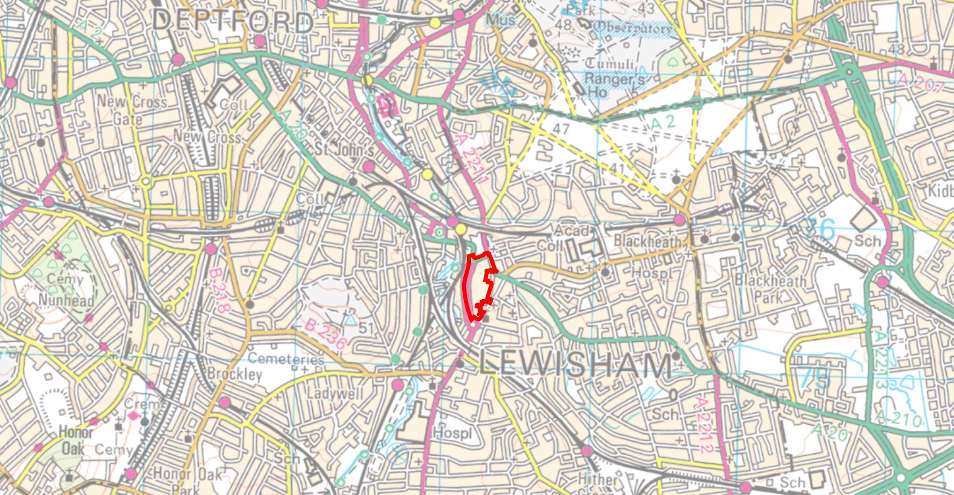
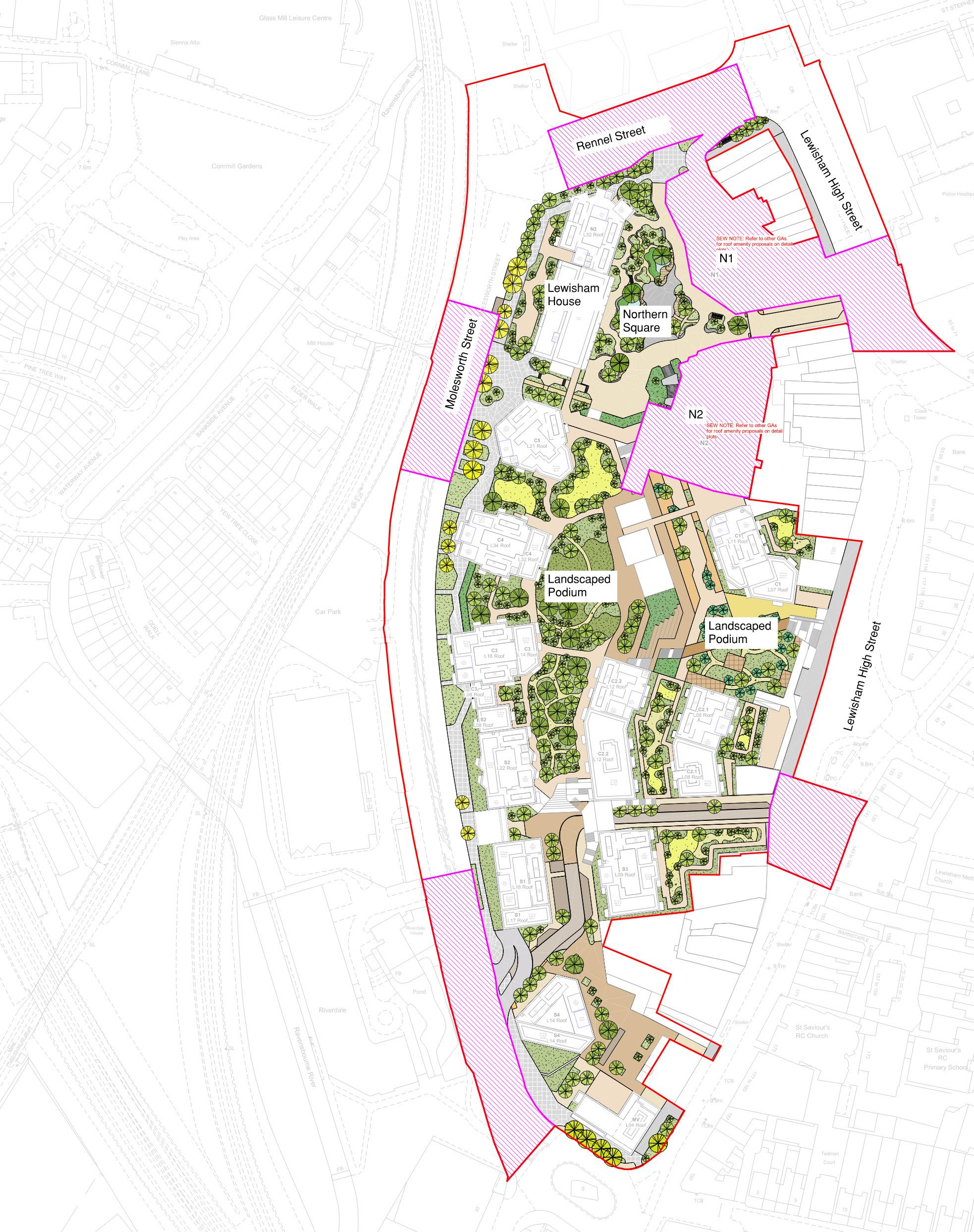
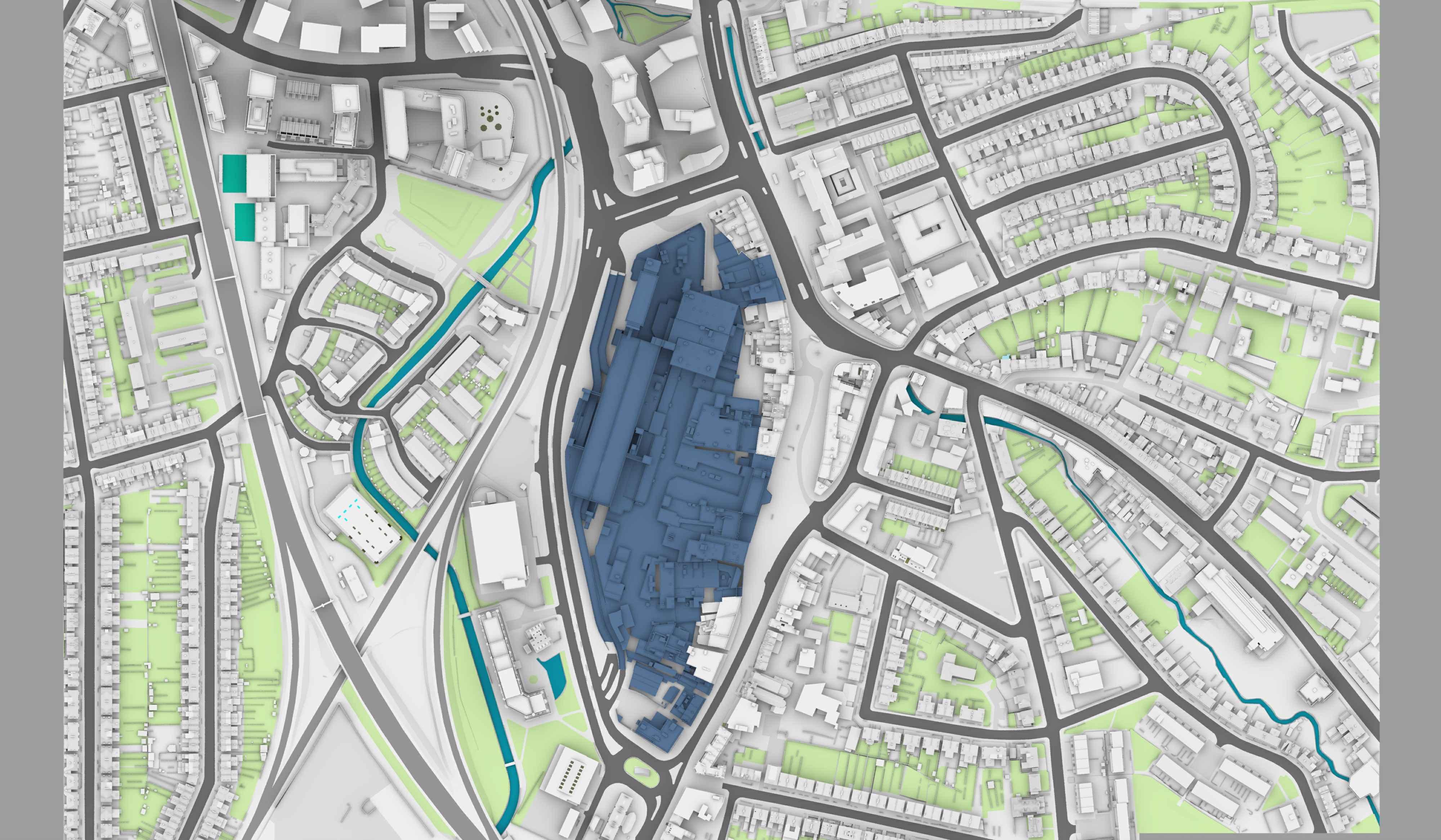
The 6.93ha site is in the London Borough of Lewisham, in Southeast London. The site is bound to the west and south by Molesworth St (A21), to the east by Lewisham High Street and to the north by Rennell Street (A20). West of Molesworth Street is the railway line and Ravensbourne River as well as a mix of green space, residential and commercial buildings.
The Lewisham DLR and railway stations are located, respectively, approximately 170m and 240m north of the site. Northeast of the site is a Police Station, east of Lewisham High Street which is then followed by shops and commercial premises running south beyond the southern tip of the site. The River Quaggy runs along the northeast of the site, on the opposite side of Lewisham High Street. The site is centred at postcode SE13 0HB and on OS grid reference 38239, 75543.
The site currently comprises the Shopping Centre, which includes a range of retail units, a multi-storey car park, the 18-storey vacant former Lewisham House office building, the vacant Leisure Box and Riverdale Hall, as well as commercial properties on the High Street. The existing Shopping Centre was built in 1977.
The River Corridor Improvement Plan Supplementary Planning Document (SPD), prepared by the London Borough of Lewisham in September 2015 [1] sets out the following key principles as part of its vision:
• Protect and enhance the environment along river corridor: environmentally sensitive design, enhance habitats and build resilience to climate change.
• Reduce flood risk: maximise opportunities to manage flood risk along river corridor and raise awareness of increasing flood risk associated with climate change.
• Support strong and prosperous communities: enhance character and identity of the river, support development responsive to river corridor, encourage public participation in active management of river corridor.
• Recreation and leisure provision to for healthy communities: high quality public space, accessible to all, safe and legible cycling and pedestrian routes, provision for water related activities where possible, improve access to leisure, cultural and sports facilities along river corridor.
This SPD recognises some sections of the river have been canalised for flood protection in the past and seeks to provide guidance on returning these sections to a more natural state without increasing flood risk, where possible.
Policy SD 9 Lewisham’s Waterways of the emerging Lewisham Local Plan (January 2023)[2] establishes the multifunctional social, economic and environmental benefits of waterways. It aims to ensure that developments adjacent to watercourses have no adverse impact on its natural functioning, and that opportunities for reducing flood risk, enhancing the water quality, ecology, amenity, recreational, historic value and safety of the watercourse are maximised.
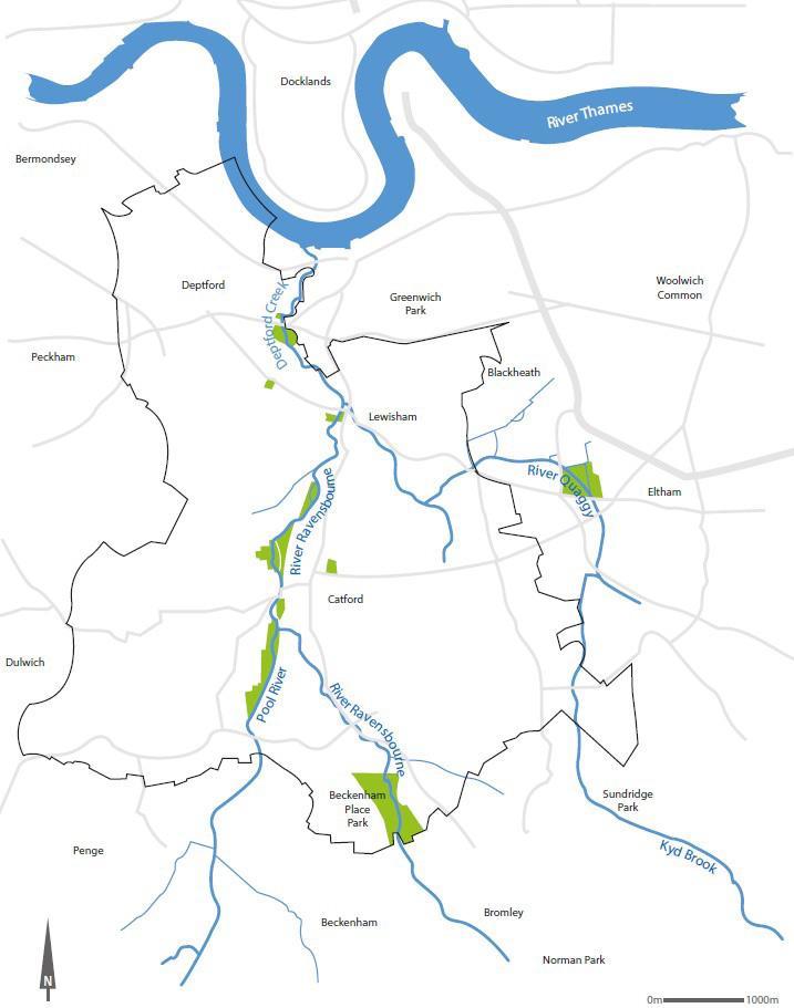
The Ravensbourne catchment includes 66km of rivers and streams, with a total catchment area of 180km2 [3] Key watercourses include the River Ravensbourne, River Pool, River Quaggy and Kid Brook. From sources at Keston, Locksbottom and Croydon the rivers broadly flow northward and discharge into the Thames at Deptford (Figure 3). The catchment contains a broad diversity of land-uses from farming, woodland, parkland, regenerated urban green spaces, urban residential, commercial and industrial uses.
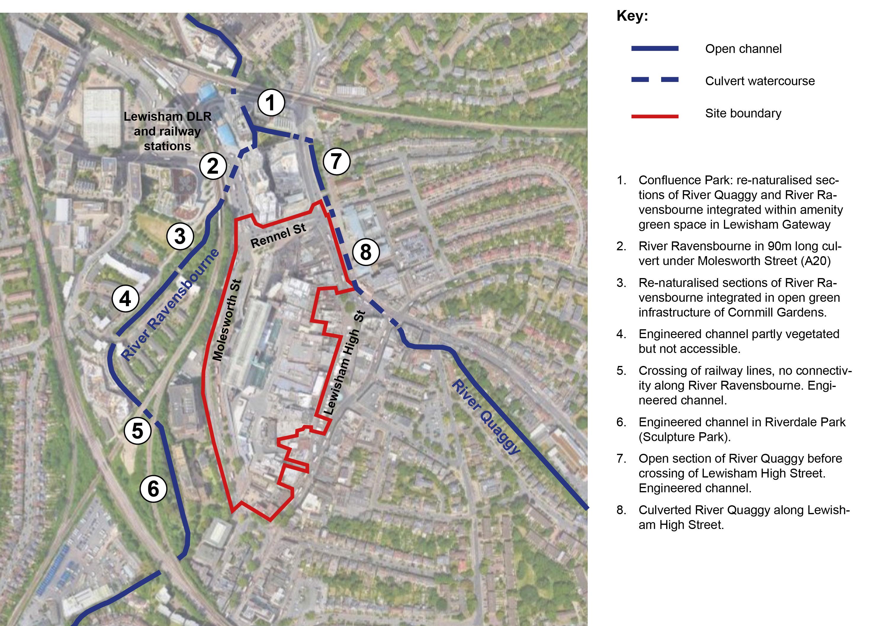
The River Ravensbourne runs to the west of the site, on the other side of Molesworth Street and the railway line. Adjacent to the site the river runs broadly northward in a concrete channel alongside Riverdale Park, under two railway lines alongside buildings and behind individual houses, in a partly naturalised engineered channel along Waterway Avenue, in a natural channel through Cornmill Gardens, before running in a 90m long culvert under the A20 and emerging in the Confluence Park green space associated with Lewisham Gateway where it is joined by the River Quaggy (Figure 2).
The River Quaggy runs along the north-east of the site. It mostly runs in a culvert parallel to Lewisham High Street before emerging adjacent to the junction with Rennel Street. It crosses the northern part of Lewisham High Street before joining the River Ravensbourne (Figure 2).
According to the London Borough of Lewisham River Corridor Improvement Plan (2015)[1], the river environment around the site is characterised by concrete channelling and culverting, and described as poor with litter along the riverbanks and limited public access. Most of the historic development along the river corridor is described as not relating well to the river.
The River Ravensbourne has been re-naturalised and restored through Cornmill Gardens and integrated in an area of public open space. Similarly, the Confluence Park, within Lewisham gateway also includes deculverted and re-naturalised river sections integrated with amenity green spaces in a dense urban environment.
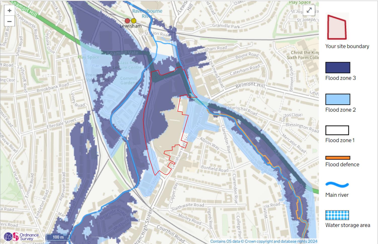
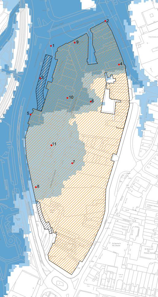
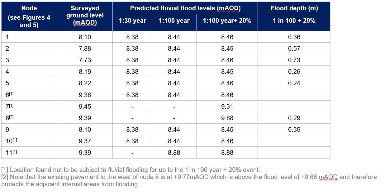
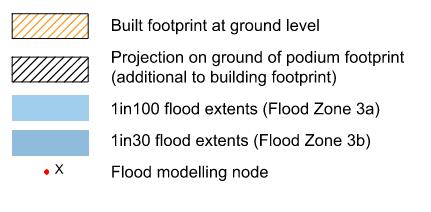
The Environment Agency (EA) flood map (Appendix A) shows significant fluvial flooding along the corridor of both the River Ravensbourne and River Quaggy. In the vicinity of the site the areas adjacent to the watercourses are within Flood Zone 3 (the 1 in 100 year fluvial flood envelope) or Flood Zone 2 (the 1 in 1000 year fluvial flood envelope). Fluvial flooding is a key issue in this part of the river catchment.
A strategic Flood risk Assessment (SFRA) has been prepared for the London Borough of Lewisham by AECOM in 2018[4] Map 004 of the SFRA (Appendix A) shows the extent of the “functional flood plain” of the River Ravensbourne and River Quaggy, and the extent of flooding across the wider catchment.
The EA flood map for planning and SFRA flood map have been found to be inaccurate in places across the site. This is explained by the strategic flood mapping produced by the EA being based on relatively coarse LIDAR data, which is inaccurate when the site is occupied by buildings. A revised flood map for the site has been produced and is included in Appendix A, mapping predicted fluvial flood levels onto a ground model generated on the results of the detailed topographical survey.
The DEFRA catchment data explorer[5] states that the Ravensbourne Operational Catchment which includes the rivers Ravensbourne and Quaggy has a ‘moderate’ ecological status and ‘fails’ the chemical status. The catchment has a 2027 objective to reach ‘good’ Ecological status and a 2063 objective to reach a ‘good’ chemical status.
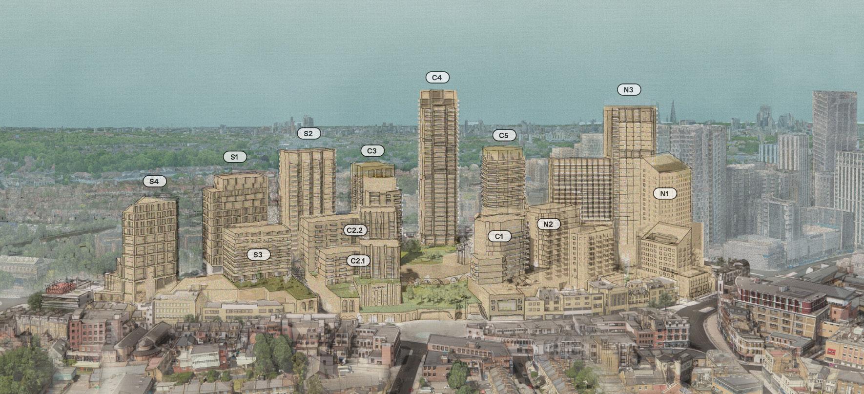
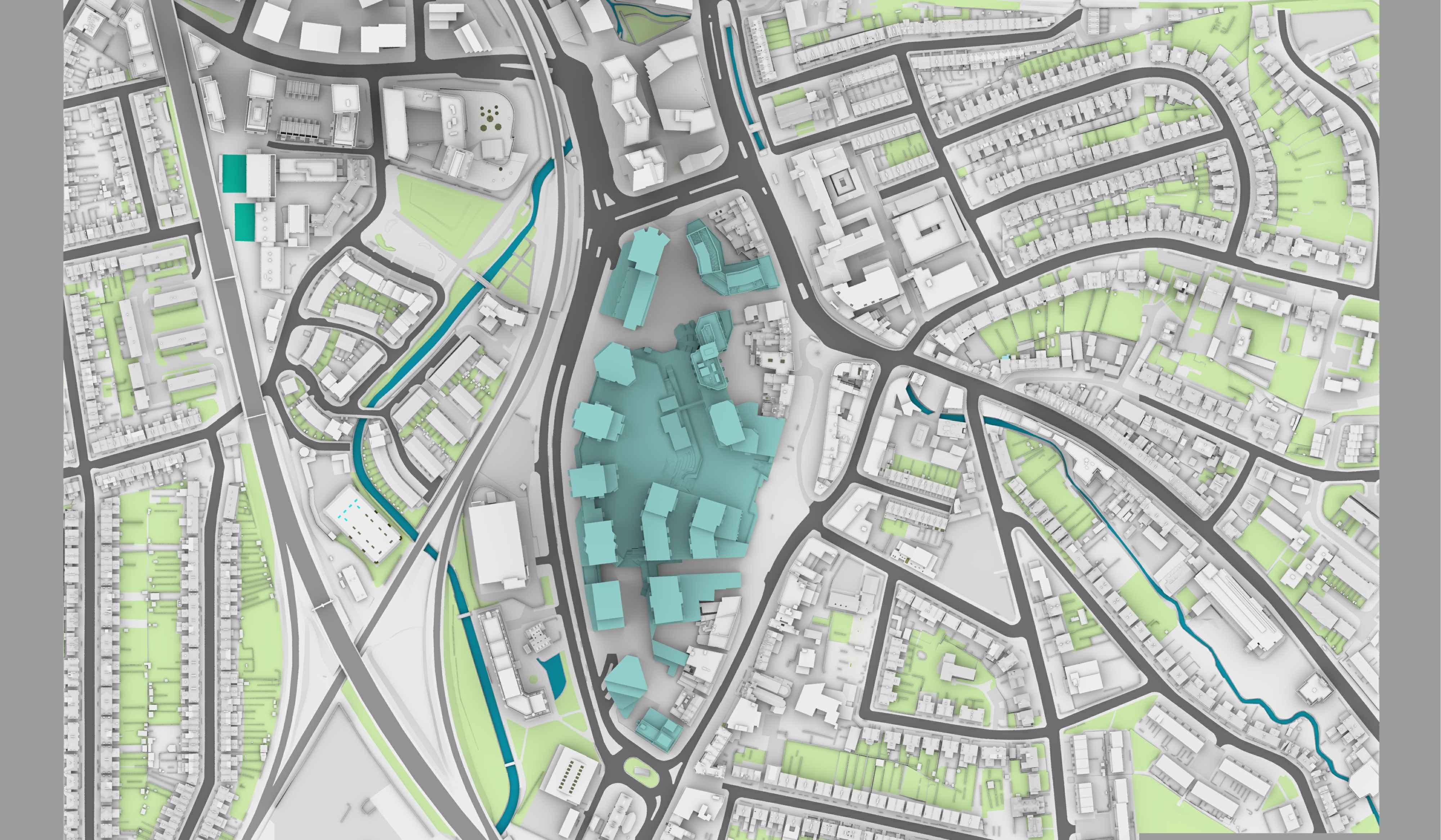
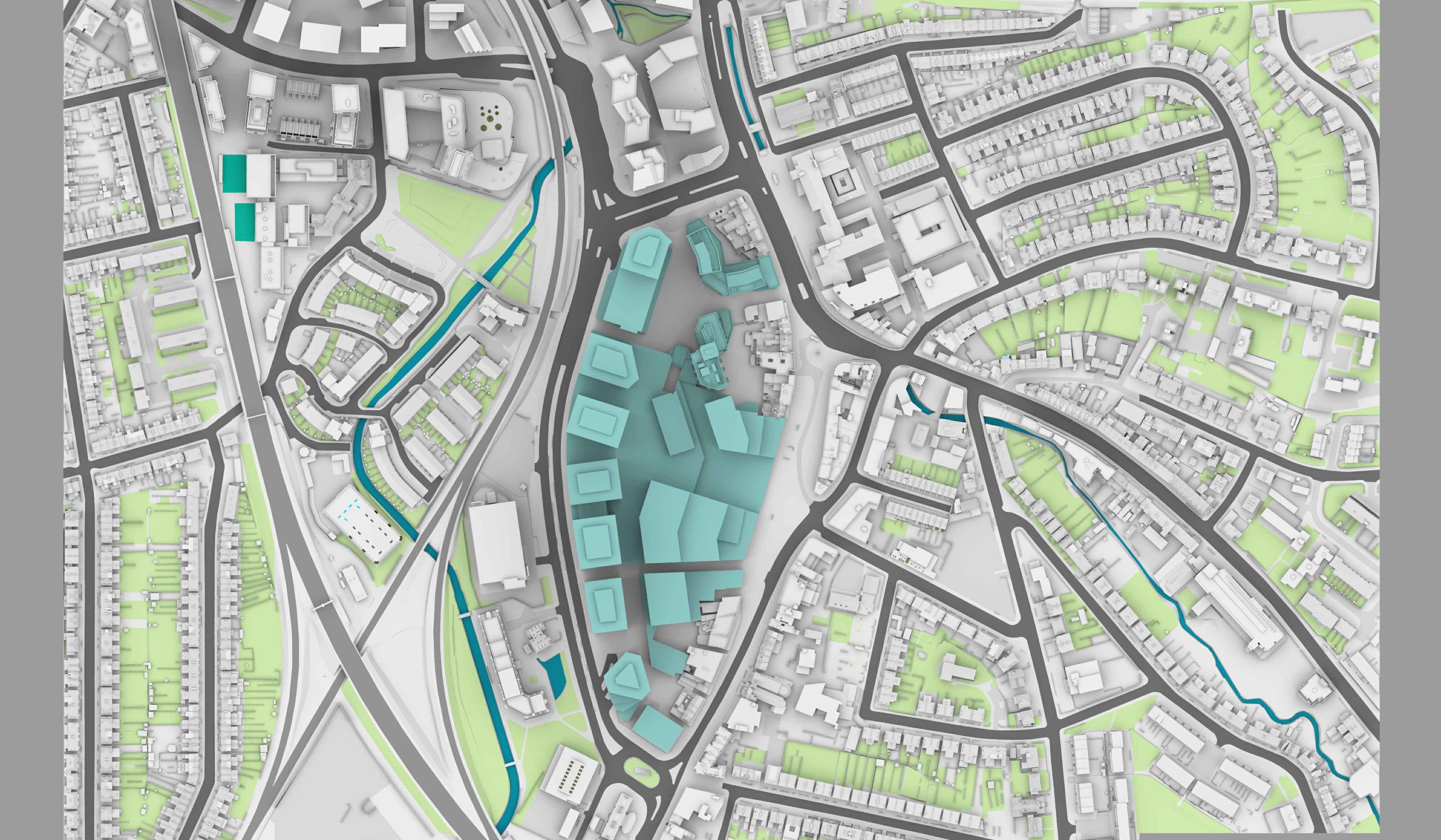
This hybrid planning application is for the comprehensive, phased redevelopment of land at Lewisham Shopping Centre and adjacent land, comprising:
• Full planning application (within Phase 1a) comprising the demolition of existing buildings, structures and associated works to provide a mixed-use development including the erection of a Co-Living building (Sui Generis) up to 23 storeys in height (Plot N1), and a residential building (Class C3) up to 15 storeys in height (Plot N2), associated residential ancillary spaces as well as town centre uses (Class E (a, b, c, d, e, f, g (i, ii)); and Sui Generis) together with public open space, public realm, amenity space and landscaping, car and cycle parking, highway works and the formation of new pedestrian and vehicle accesses, existing shopping centre interface works (the ‘Phase 1a Finish Works’), service deck modifications, servicing arrangements, site preparation works, supporting infrastructure works and other associated works.
• Outline planning application (all matters reserved) for a comprehensive, phased redevelopment, comprising demolition of existing buildings, structures and associated works to provide a mixed-use development including:
• The following uses:
• Living Uses, comprising residential (Class C3) and student accommodation (Sui Generis)
• Town Centre Uses (Class E (a, b, c, d, e, f, g (i, ii)) and Sui Generis); and
• Community and Cultural uses (Class F1; F2; and Sui Generis).
• Public open space, public realm, amenity space and landscaping works;
• Car and cycle parking;
• Highway works;
• Formation of new pedestrian and vehicular accesses, permanent and temporary vehicular access ramps, service deck, servicing arrangements and means of access and circulation within the site;
• Site preparation works;
• Supporting infrastructure works;
• Associated interim works;
• Meanwhile and interim uses; and,
• Other associated works.
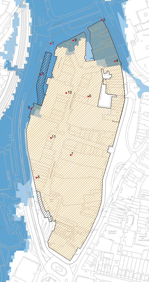
The proposed masterplan is shown in Figures 4 and 5. Development proposals are included in Appendix B.
The potential impact of the proposed development on the River Ravensbourne and River Quaggy has been appraised considering:
• Overshadowing: undue overshadowing of the watercourse can be detrimental to ecology and the amenity value of the river network. Local policy seeks to protect and enhance habitats along the river corridor, build ecological resilience to climate change and enhance amenity and recreational use.
• Flood risk: the area is subject to significant fluvial flooding and both the River Ravensbourne and River Quaggy are associated with fluvial floodplain, the functions of which need to be protected. Local Policy seeks to reduce flood risk along the river corridor and manage surface water runoff in a sustainable way.
• Water quality: the water and ecological quality of both watercourses is noted to be relatively poor. Targets have been set for improving the quality of the watercourses, which will play a key part in enhancing the river environment.
Improvement of access to the River Ravensbourne corridor and connectivity of existing riverside green spaces with the proposed green spine and park of the proposed development is also discussed.
A Sun on Ground (SoG) analysis has been carried out by Point 2 Consultants with reference to the BRE Guidelines (2022)[6]. This sets out that at least 50% of the defined surface area should receive at least 2 hours of sunlight on 21 March, or if the existing condition records below 50%, the area should not experience change more than 0.8 times its former value (in other words allowing a permissible 20% change from former value).
The technical analysis has been completed considering the maximum development parameters and separately considering the illustrative scheme.
Table 1 below summarises the results for both scenarios.
Given the relatively large distance separating the River Ravensbourne corridor and northern open section of the River Quaggy from the proposed buildings, the BRE requirements of achieving solar access on 50% of the area are significantly exceeded. The proposed development would result in a marginal reduction of solar access considered to not significantly affect the environmental quality of the river corridors.
The short open section of the River Quaggy to the east of the site between Lewis Grove and Clarendon Rise at present only receives sunlight on 17.2% of its area on 21 March due to the density of existing surrounding buildings. It therefore does not achieve the BRE requirements. The proposed development does not affect this section of the river.
Results for the existing buildings within the site and illustrative masterplan are included on Figures 6 and 7. Full results are included in Appendix C.
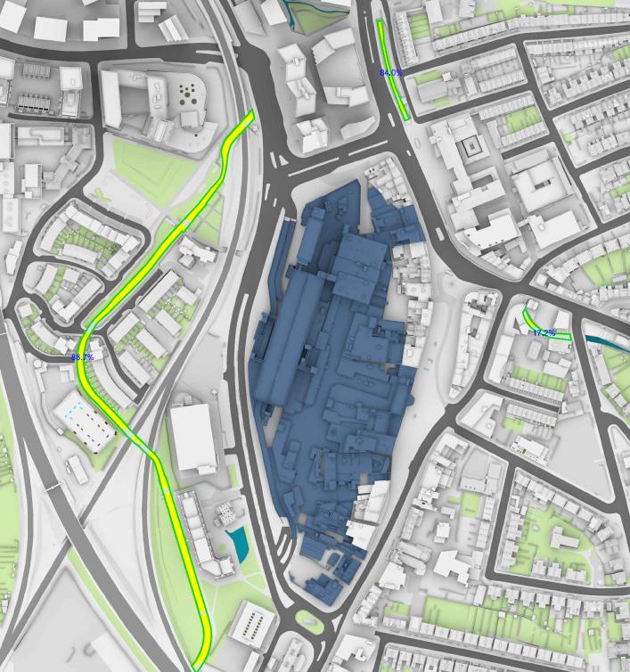

-open section along northern part of Lewisham High Street)
Quaggy -open section to East of site adjacent to Lewis Grove
The Flood Risk Assessment prepared by Expedition to accompany this planning application proposes mitigation measures to ensure the development is not affected by flooding, and does not increase flood risk elsewhere.
Any loss of floodplain storage volume has been compensated on a level-by-level and volume-by-volume basis. Loss of floodplain storage has been compensated by lowering levels within the Northern Square and connecting these levels to flooded area along Rennell Street. Fluvial overland flow routes have also been considered to ensure the proposed development does not have a detrimental impact.
As set out in the Sustainable Drainage Strategy prepared by Expedition to accompany this planning application, the site is mostly impermeable, and surface water is discharged un-attenuated to a local surface water sewer that outfalls in the River Quaggy, and to the local combined sewer network.
It is proposed to increase the site catchment discharging to the River Quaggy from 12 to 40%, and limit peak discharge to peak greenfield runoff rates. The surface water drainage system is also designed to contain the 1:100 year + 40% event on site. At present such events overflow onto roads and in the river system.
Lastly, the large extent of proposed podium planting, permeable pavement areas, soft landscape and sustainable urban drainage features, and harvesting of rainwater will increase retention of water on site and positively contribute to reducing long term flooding.
As such, overall the proposed development will result in a reduction of flood risk in the river catchment.
The Sustainable Drainage Strategy sets out the approach adopted to control runoff at source and intercept diffuse pollutants following best practice for the SUDS Manual (CIRA C753). A combination of green roofs, podium planting, permeable pavement, raingardens and ponds will reduce pollution loads and have a positive impact on water quality in the receiving watercourses.
The proposed development includes the creation of a large park on the podium deck which will provide significant green and amenity spaces for the occupants and residents of the scheme as well as the wider community. This will also act as a green spine connecting Lewisham DLR and railway stations and other green spaces to the south including Riverdale Park along the River Ravensbourne. It will generally contribute to improving wider access to the river corridor and help mitigate anti-social behaviour in Riverdale Park.
During the design development of the scheme, and in consultation with the Environment Agency and the London Borough of Lewisham, opportunities for improving connectivity along the River Ravensbourne, between Riverdale Park and Cornmill Gardens have been explored. The key barrier to connectivity are the two railway lines. Opportunities for crossing these railway lines with a boardwalk in the river under the existing railway bridges have been discussed. The technical feasibility of such approach would need to be tested further, carefully considering the impact on fluvial flood risk, river ecology, safety, and the railway lines in consultation with key stakeholders. However, as the scheme would not have any detrimental impact on the river corridor, no direct mitigation are required and as such improvements of connectivity along the river corridor are not parts of the development proposals.
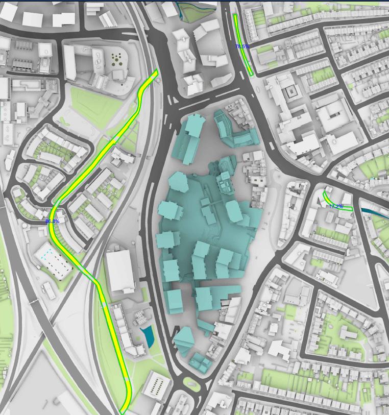
A Sun on Ground analysis has been carried out by Point 2 Consultants. Given the relatively large distance separating the River Ravensbourne corridor and northern open section of the River Quaggy from the proposed buildings, the BRE requirements for solar access are significantly exceeded. The proposed development would result in a marginal reduction of solar access considered to not significantly affect the environmental quality of the river corridors. The short open section of the River Quaggy to the east of the site between Lewis Grove and Clarendon Rise currently does not achieve the BRE requirements, but would not be affected by the proposed development.
As setout in the Flood Risk Assessment, the proposed development would result in no detrimental impact on fluvial floodplain storage volume and overland flows.
The Sustainable Drainage Strategy establishes that the site catchment discharging to the River Quaggy will be increased from 12 to 40%, peak discharge will be limited to peak greenfield runoff rates, and the 1:100 year + 40% water will be contained on site. The large extent of proposed podium planting, permeable pavement areas, soft landscape and sustainable urban drainage features, and harvesting of rainwater will increase retention of water on site and positively contribute to reducing long term flooding. As such, overall the proposed development will result in a reduction of flood risk in the river catchment.
The Sustainable Drainage Strategy sets out the approach adopted to control runoff at source and intercept diffuse pollutants following best practice which will have a positive impact on water quality in the receiving watercourses.
The green infrastructure proposals, and in particular the creation of a large park on the podium deck will bring significant benefits to the users and residents of the scheme as well as the wider community. This will generally contribute to improving wider access to the river corridor and help mitigate anti-social behaviour in Riverdale Park.
Opportunities for improving connectivity along the River Ravensbourne, between Riverdale Park and Cornmill Gardens have been discussed, and their technical feasibility would need to be tested further. However, as the scheme would not have any detrimetal impact on the river corridor, no direct mitigation are required and as such improvements of connectivity along the river corridor are not parts of the development proposals.
1. River Corridor Improvement Plan, Supplementary Planning Document, London Borough of Lewisham, September 2012
2. Lewisham Local Plan - Proposed submission document Regulation 19 stage - January 2023
3. Ravensbourne Catchment Plan 2015-2021, led by Thames 21 and developed with a number of stakeholders.
4. AECOM. (2018-2020). London Borough of Lewisham Strategic Flood Risk Assessment level 1 and Level 2 Reports.
5. Ravensbourne Operational Catchment | Catchment Data Explorer. (2024). https://environment.data.gov.uk/ catchment-planning/OperationalCatchment/3369/print.
6. Site layout planning for daylight and sunlight: a guide to good practice, BRE 209, 2022.
C - Overshadowing assessment
Sources:
Point2Surveyors
PointCloudSurvey(received20/10/20),(received06/07/21)
SitePhotographs
EgretWest
ProposedInfo(received18/10/23)
0386-SEW-ZZ-ZZ-M3-A-00000_NoContext_Detached_231012.dwg
0386-SEW-ZZ-ZZ-M3-A-00001_MaxExtentsParameters_Without Context_Detached_231012.dwg
The table below summarises the requirements for the River Impact Assessment as agreed with the Local Planning Authority and how they have been addressed in this document.
The study should include: References in document
Water features on location and site/block plans including rivers and culverts;
Daylight & Sunlight Assessment, noting that any undue overshadowing of waterspace can be detrimental to ecology and amenity..
Demonstrate how the development has sought to enhance the use, enjoyment and setting of the river (including details of any river restoration projects
Sites which adjoin a river must also include plans showing proposed river enhancements, including in-channel enhancements as appropriate
Refer to Figures 2 and 6.
Refer to Section 6.2 and Appendix C..
Refer to Section 6.5
The site is not directly adjacent to the River Ravensbourne or River Quaggy, as as such direct river enhacements are not part of the development proposals.