1 Introduction
1.1 This Health Impact Assessment (HIA) has been prepared by Quod on behalf of Landsec Lewisham Limited (“Landsec”, the ‘Applicant’) in support of the Application for Hybrid Planning Permission (part detailed and part outline) for the proposed redevelopment of Lewisham Shopping Centre and adjacent land (the ‘Site’).
Proposed Development
1.2 The description of the Proposed Development being applied for is:
Hybrid planning application for the comprehensive, phased redevelopment of land at Lewisham Shopping Centre and adjacent land, comprising:
Full planning application (within Phase 1a) comprising the demolition of existing buildings, structures and associated works to provide a mixed-use development including the erection of a Co-Living building (Sui Generis) up to 23 storeys in height (Plot N1), and a residential building (Class C3) up to 15 storeys in height (Plot N2), associated residential ancillary spaces as well as town centre uses (Class E (a, b, c, d, e, f, g (i, ii)); and Sui Generis) together with public open space, public realm, amenity space and landscaping, car and cycle parking, highway works and the formation of new pedestrian and vehicle accesses, existing shopping centre interface works (the ‘Phase 1a Finish Works’), service deck modifications, servicing arrangements, site preparation works, supporting infrastructure works and other associated works.
Outline planning application (all matters reserved) for a comprehensive, phased redevelopment, comprising demolition of existing buildings, structures and associated works to provide a mixed-use development including:
• The following uses:
• Living Uses, comprising residential (Class C3) and student accommodation (Sui Generis);
• Town Centre Uses (Class E (a, b, c, d, e, f, g (i, ii)) and Sui Generis);
• Community and Cultural uses (Class F1; F2; and Sui Generis);
• Public open space, public realm, amenity space and landscaping works;
• Car and cycle parking;
• Highway works;
• Formation of new pedestrian and vehicular accesses, permanent and temporary vehicular access ramps, service deck, servicing arrangements and means of access and circulation within the site;
• Site preparation works;
• Supporting infrastructure works;
• Associated interim works;
• Meanwhile and interim uses and
• Other associated works.”
1.3 The Site is in Lewisham Central ward and is also close to Blackheath Ward. The shopping centre is home to a range of occupiers, including national, larger retailers such as Sainsburys, M&S, TK Maxx and JD in addition to smaller independent units.
1.4 Lewisham Shopping Centre is located at the heart of Lewisham town centre, the largest town centre within the Borough and is a key focal point, serving a diverse catchment of residents.
1.5 The HIA sets out the overarching view on health issues relevant to the Site across the following geographical levels (where data is available):
▪ Lewisham Central and Blackheath ward (‘Local Area’)1;
▪ London Borough of Lewisham (LBL);
▪ London; and
▪ England.
Health and Planning
1.6 The Lewisham Validation Checklist for Major Development2 outlines that all major development proposals (where 10 or more dwellinghouses are proposed) are required to produce a Health Impact Assessment (HIA). It is stated that a HIA should be undertaken as early as possible in the plan making or design process to identify opportunities for maximising potential health gains, minimising harm, and addressing health inequalities.
1.7 Policy DM6 ‘Health Impact Assessments’ of the Lewisham Local Plan: Submission Version (January 2023)3 states that a desktop Health Impact Assessment (HIA) must be submitted for major developments, developments located within an Air Quality Focus Area and developments which include hot-foodtakeaways, betting shops, education facilities, health and social care facilities, leisure and community facilities and publicly accessible open space. In addition to this, development proposals of a scale referable to the Greater London Authority (GLA) must also submit a detailed HIA.
1.8 The policy states that Health Impact Assessments (HIAs) will be required for development proposals that are most likely to have an impact on public health outcomes whether by virtue of their ‘large scale’, ‘nature of uses’ or ‘location’. could potentially have impacts on health and wellbeing. The drafting of an HIA as part of the planning process identifies potential effects arising from development and outlines proposed measures to maximise positive effects and minimise any adverse effects.
1.9 Health is influenced by a combination of biological and environmental factors. However, environmental factors can be influenced through design and management of buildings and
1 The definition of these wards changed in 2022, we have used this most recent definition for data collection unless stated otherwise.
2 London Borough of Lewisham, 2022. London Borough of Lewisham Validation Checklist: Planning Permission for Major Development.
3 London Borough of Lewisham, 2024. Lewisham Local Plan – Proposed submission document (Regulation 22 stage).
spaces which may be able to impact on health outcomes. These are recognised as the ‘wider determinants of health’ and include:
▪ General socio-economic, cultural and environmental conditions;
▪ Living and working conditions;
▪ Social and community influences; and
▪ Individual lifestyle factors.
1.10 Planning and development can play a role within these wider determinants of health. The Marmot Review (2020)4 outlines that, although there has been some progress since 2010, evidence shows levelling off of life expectancy gains and a widening of the gap in health inequalities. The box overleaf indicates how these interactions work.
1.11 The relationship between the built environment and opportunity provided by the planning system to embed health and wellbeing are established in Public Health England guidance on Health Impact Assessment in Spatial Planning5. This has informed the approach of this HIA.
1.12 The Proposed Development would provide new homes, student accommodation, open space, public realm and commercial and community spaces. Development of this size and nature can contribute both positively and negatively to health outcomes locally. It is important that the HIA acknowledges both positive and negative health impacts that may arise from development, in order to maximise any health benefit and mitigate against any adverse impacts.
1.13 This HIA is structured as follows:
▪ Section 2: Planning Policy and Guidance Framework
▪ Section 3: Methodology
▪ Section 4: Baseline Profile
▪ Section 5: Health Pathways and Heath Impact Assessment (including proposed mitigation and management).
4 Marmot, M., Allen, J., Boyce, T., Goldblatt, P., Morrison, J. (2020). Health Equity in England: The Marmot Review 10 Years On. Institute of Health Equality.
5 PHE (October 2020). Health Impact Assessment in Spatial Planning: A guide for local authority public health and planning teams
Health and Planning
The World Health Organisation (WHO) defines health as a state of complete physical, mental and social well-being and not the absence of disease or infirmity.
An ever-growing body of research indicates that the environment in which we live is inextricably linked to our health, and whilst the causal links between the built environment and health are often complex, research consistently reports that most health outcomes are influenced by factors other than genetics and healthcare6

Barton and Grant’s health map7 (shown above) highlights the relationship between health and these wider physical, social, economic, and environment factors (the ‘wider determinants of health’). The direct process of planning and development is highlighted within one sphere, the ‘built environment’, however development can have wider reaching effects on health with direct or indirect effects on wider spheres of life and society. For example, the design of neighbourhoods can influence physical activity levels, travel patterns, social connectivity and mental and physical health outcomes.
6 Public Health England, 2017. Spatial Planning for Health: An evidence resource for planning and designing healthier places.
7 Barton, H., and Grant, M. 2006. A health map for the local human habitat. The Journal of the Royal Society for the Promotion of Health, 126 (6). Pp. 252-253 (modified from Dahlgren and Whitehead (1991)).
2 PlanningPolicy&GuidanceFramework
Regional and National Planning Policy
2.1 Chapter 8 ‘Promoting Healthy and Safe Communities’ of the National Planning Policy Framework (NPPF), 20238 sets out a planning framework relevant to human health. It emphasises that planning and development should “aim to achieve healthy, inclusive and safe places” (para. 92).
2.2 The Planning Practice Guidance (PPG)9 highlights the role of health, setting out the importance for Local Planning Authorities (LPAs) to identify local health needs and to plan effectively for the future. This includes working closely with other public health organisations and providers to support health infrastructure and promote healthy communities.
2.3 The London Plan (2021)10 Policy GG3 ‘Creating a Healthy City’ emphasises the priority to reduce health inequalities and improve the overall health of Londoners, requiring that wider determinants of health are addressed through development in an integrated and co-ordinated manner. Specifically, the policy requires that potential impacts of development proposals on mental and physical health of communities are assessed to “mitigate any potential negative impacts, maximise potential positive impacts, and help reduce health inequalities, for example through the use of Health Impact Assessments”.
2.4 The London Health Inequalities Strategy (2018)11 seeks to address persistent and, in some cases, widening health inequalities in London. The Strategy highlights that addressing the wider determinants of health (“the conditions in which people are born, grow, live, work and age”) is the most important thing that can be done to tackle health inequalities, and that development has significant potential to achieve this.
Local Planning Policy
2.5 The current adopted Lewisham Core Strategy12 sets out the vision, objectives and policies that will guide both the public and private sector investment to manage development and regeneration. Lewisham’s vision within the core strategy is underpinned by six key outcomes. Four of these outcomes are of direct relevance to the HIA which are as follows:
▪ Safer Lewisham – where people feel safe and free from crime, antisocial behaviour and abuse
▪ Clean, green and liveable Lewisham – where people live in high quality housing and can enjoy their environment
8 Ministry of Housing, Communities and Local Government, 2023. National Planning Policy Framework. London. HMSO.
9 Ministry of Housing, Communities and Local Government (Live Document) Planning Practice Guidance [online]
Available: http://planningguidance.communities.gov.uk/
10 GLA, 2021. The London Plan – March 2021.
11 GLA, 2018. The London Health Inequalities Strategy.
12 London Borough of Lewisham, 2011. Core Strategy – Development plan document
▪ Healthy, active and enjoyable Lewisham – where people can participate in maintaining and improving their health and wellbeing
▪ Dynamic and prosperous Lewisham – where people are part of vibrant communities and town centres, which are well connected to London and wider areas.
2.6 The strategic objectives set out within the Core Strategy that are of direct relevance to health are as follows:
▪ Objective 3: Local housing need – provision to be made to meet the housing needs of Lewisham’s new and existing population, including a provision of affordable housing, a mix of dwelling sizes andtypes, lifetime homes tomeet the needs of an ageing population and bringing vacant dwellings back to use
▪ Objective 5: Climate change – Council will take action to ensure that climate change is adapted to and mitigated against, with measures including promoting resource and water efficiency, maximising the generation of renewable energy, building to high standards of sustainable design, reducing waste generation, supporting environmental protection and minimising the environmental impacts of development
▪ Objective 7: Open spaces and environmental assets – Environmental, ecological and biodiversity features of Lewisham will be protected to promote health and wellbeing by promoting all open space (including MOL), protecting SINCs, promoting local biodiversity, improving the air quality of all public space and providing accessible and varied opportunities for health, leisure and recreational activities
▪ Objective 8: Waste Management – delivering sustainable waste management by implementing the waste hierarchy of prevent, reuse, compost and recycle
▪ Objective 9: Transport and accessibility – making provision to ensure an accessible, safe, convenient and sustainable transport system for Lewisham that meets people’s access needs and reduces the need for private cars
▪ Objective 11: Community well-being – to provide and support measures and initiatives that promote social inclusion and strengthen the quality of life and well-being for new and existing residents of the Borough by addressing deprivation and health inequality, reducing crime and providing high quality physical, social and green infrastructure.
2.7 Policies of particular relevance to the HIA are as follows:
▪ Core Strategy Policy 7: Climate change and adapting to the effects – Council will adopt a partnership approach to implement the principles of ‘avoidance, mitigation and adaptation’ to reduce carbon dioxide emissions by raising awareness of climate change issues, promoting the sustainable use of land and recognising the role that reuse and modification can play in tacking climate change
▪ Core Strategy Policy 9: Improving air quality – Council will seek to improve local air quality and minimise negative air quality impacts by working with TFL and businesses to manage air quality, in addition to adopting a coordinate approach to implement London Plan and National policy
▪ Core Strategy Policy 12: Open space and environmental assets – Council will conserve nature, green the public realm and provide opportunities for sport, recreation, leisure and wellbeing by protecting the character and amenity of open spaces, maintaining and improving the publicly accessible open space network, preserving the local biodiversity
conservation interests, improving access to existing open space, maximising opportunities for sport and recreation and promoting local food growing
▪ Core Strategy Policy 14: Sustainable movement and transport – Council will promote the access and safety of pedestrians and cyclists, maintain and improve all walking and cycling routes, make cycle parking a requirement for new developments and work with Transport for London, Network Rail and other partners to ensure the delivery of necessary transport infrastructure
▪ Core Strategy Policy 19: Provision and maintenance of community and recreational facilities – Council will work with its partners to ensure a range of health, education, policing, community, leisure, arts, cultural, entertainment, sports and recreational facilities and services are provided, protected and enhanced across the Borough.
▪ Core Strategy Policy 20: Delivering educational achievements, healthcare provision and promoting healthy lifestyles – Council will support the Local Education Authority’s School Implementation Plan and the broad range of education and training opportunities provided by local groups to strengthen local skill levels, in addition to improving health and promoting healthy lifestyles by exploring new opportunities for healthy and active lifestyles, identify potential health impacts of new development and reducing health inequalities across the Borough
2.8 The Lewisham Local Plan: Submission Version (January 2023)13 highlights the key health issues across the Borough. Lewisham recognises that the area is currently a place of stark contrast with the Borough containing areas of both deprivation and wealth. The LBL have recognised that the area currently suffers from significant health inequalities, with life expectancies at birth for Lewisham’s male residents being lower than the national average. The Local Plan also highlights the fact that more than half of Lewisham’s adult population are either overweight or obese, with children living in the Borough’s most deprived areas being twice as likely to be obese or overweight when compared to children from other areas14
2.9 LBL are committed to improving outcomes related to the wider determinants of health including supporting healthy lifestyles, improving air quality and reducing pollution, in addition to tackling fuel poverty, addressing problems of housing affordability, delivering more accessible homes, enhancing green infrastructure and securing a net gain in biodiversity.
2.10 LBL’s strategic objectives of relevance to health are as follows:
▪ Housing tailored to the community with genuinely affordable homes – responding to population growth and helping to meet London’s and Lewisham’s housing needs by positively managing the delivery of new homes, ensuring that Lewisham’s existing and future residents have good access to a wide range and mix of housing and helping to reinforce community cohesion
▪ A greener Borough – ensuring that all people in Lewisham benefit from access to high quality green spaces by protecting, enhancing and connecting the Borough’s network of parks, open and water spaces, promoting and protecting the ecological, biodiversity and
13 See footnote 2
14 Lewisham Joint Strategic Needs Assessment. Picture of Lewisham (2021).
amenity value of the Borough’s natural assets and managing waste by prioritising the implementation of the most sustainable options in the waste hierarchy
▪ Responding to the climate emergency - realising long-term reductions in energy use and carbon emissions in helping London to become a net zero carbon city by 2050 and managing flood risk by ensuring that new development is appropriately located
▪ Healthy and safe communities – addressing the wider determinants of physical and mental health and deprivation in an integrated and systematic way, creating an environment that encourages and enables people to pursue active and healthy lifestyles, promoting cohesive and mixed communities along with walkable and liveable neighbourhoods and creating safer neighbourhoods while improving perceptions of safety by ensuring that built environment comprises welcoming spaces
▪ Ensuring high quality education, health and social care – ensuring that all Lewisham’s residents benefit from access to high quality education, health and social care by protecting and planning for facilities to meet local needs
2.11 The policies of relevance to this assessment include:
▪ Policy QD3 ‘Public realm and connecting places’ – Development proposals must use the design led approach to secure a high quality public realm, and must positively respond to the movement and connective function of the public realm, by encouraging walking, cycling and use of public transport. Proposals must seek to improve connections to existing or planned transport and community infrastructure, make provision for cycle parking, enhance connections that make a positive contribution to locality, avoid barriers that unnecessarily restrict movement and integrate trees and other urban greening measures.
▪ Policy CI3 ‘Sports, recreation and play’ – development proposals should help to ensure that people of all ages and abilities have access to a wide range of opportunities for sports, recreation and play
▪ Policy GR1 ‘Green infrastructure and Lewisham’s Green Grid’ – development proposals must investigate and maximise any opportunities to enhance existing green infrastructure and create new provision on site, in addition to making arrangements for the long term management of green areas and planting.
▪ Policy GR2 ‘Open Space’ – development proposals should maximise opportunities to introduce new publicly accessible open space, giving priority to green space, as well as improving connections to existing or planned new open spaces, particularly in areas of open space deficiency
▪ Policy GR3 ‘Biodiversity and access to nature’ – Development proposals must seek to avoid harm to biodiversity, while where it is demonstrated that harm is unavoidable and the benefits of the development proposal outweigh the impacts on biodiversity, the mitigation hierarchy to minimise impacts must be to avoid damaging the significant ecological features of the site, minimise the overall spatial impact (mitigating it by improving the management of the rest of the site) and delivering off-site compensation of better biodiversity value. Development proposals should secure a minimum biodiversity net gain of 10%.
▪ Policy GR4 ‘Lewisham Links’ – Development proposals must provide public realm enhancements to support the delivery of the Lewisham Links where they are located adjacent to an existing or proposed route of the Lewisham links, with public realm
enhancements including new or enhanced footpaths/cycleways, road realignment, street crossings or other safety measures, cycle parking, external lighting, landscaping, tree planting, drinking water fountains, public conveniences and way finding signage.
▪ Policy GR6 ‘Food growing’ – Major development proposals for housing or community facilities will be encouraged to provide space for community gardening and food growing.
▪ Policy SD1 ‘Responding to the climate emergency’ – All development proposals must help Lewisham become net-zero carbon Borough, protect and maximise opportunities to enhance the network of green and open spaces, conserve sites of importance for biodiversity, implement measures to reduce flood risk, not adversely impact on the amenity of the local population and help London achieve waste net self-sufficiency
▪ Policy SD3 ‘Minimising greenhouse gas emissions’ – Development proposals must be designed to reduce greenhouse gas emissions in operation and minimise energy demand, with Major development proposals needing to meet the minimum on-site reduction of Carbon emissions in addition to calculating and minimising emissions from any part of the development that are not covered by building regulations. Development proposals should also seek to minimise energy demand of the buildings(s) in use by seeking to achieve London Energy Transformation Initiative (LETI) targets, with major residential developments having a target of reducing energy consumption to 35 kWh/m2 per/year.
▪ Policy SD4 ‘Energy infrastructure’ – Development proposals must be designed in response to site-specific assessment of the most effective and efficient energy supply options, with major developments expected to engage at an early stage. Policy also states that major housing development proposals should prioritise connection to decentralised heat networks.
▪ Policy SD6 ‘Improving air quality’ – With poor air quality being a significant public health issue in Lewisham, all new development must use the design-led approach and integrate on-site measures to improve air quality, not lead to further deterioration of existing poor air quality, not create any new areas that exceed air quality limits and not create unacceptable risk of high levels of exposure to poor air quality.
▪ Policy SD12 ‘Reducing and sustainably managing waste’ – the Council will ensure that waste is sustainably managed in ways that protect human health and the environment, with a circular economy approach being promoted to conserve and make a more efficient use of resources, by increasing the re-use and recycling of materials. Development proposals must apply the waste hierarchy and follow circular economy principles.
▪ Policy TR1 ‘Sustainable transport and movement’ – Development proposals should make the most effective use of land an optimise the capacity of sites by taking into account connectivity an access to both existing and planned future public transport. Proposals should also seek to improve and must not adversely impact on the effective functioning and safe use of Lewisham’s transport network and public realm (including walking and cycling transport infrastructure).
▪ Policy TR3 ‘Healthy streets as part of healthy neighbourhoods’ – Development proposals will be expected to demonstrate how they have applied the London Plan Health Streets Approach, with proposals being supported where project leads have engaged positively with the Healthy Streets Approach to deliver public realm and other improvements that support walking. Development proposals must also safeguard and
contribute to maintaining and enhancing the Borough’s network of walking routes and cycleways, while the provision of end-of-trip facilities for cyclists that are easy to access and are designed in accordance with the London Cycling Design Standards is also encouraged.
▪ Policy LCA2 ‘Lewisham major centre and surrounds’ – Development proposals will be expected to contribute to enhancing the public realm, by promoting movement by walking, cycling and the use of public transport to make the town centre a significantly more accessible, safer, healthier and attractive place. Proposals will also be expected to improve access and permeability in the town centre, and within its surrounding area.
2.12 LBL’s Joint Strategic Strength and Needs Assessment sets out the public health challenges and opportunities. Lewisham’s Health and Wellbeing Board has identified nine priority outcomes that form the basis of the Lewisham Health and wellbeing Strategy. These priorities are as follows:
▪ Achieving a Healthy Weight
▪ Increase the number of people who survive colorectal, breast and lung cancer for 1 and 5 years
▪ Improving Immunisation Uptake
▪ Reducing Alcohol Harm
▪ Preventing the uptake of smoking among children and young people and reducing the numbers of people smoking
▪ Improving Mental Health and Wellbeing
▪ Improving Sexual Health
▪ Delaying and reducing the need for long term care and support
▪ Reducing the number of emergency admissions for people with long-term conditions
3 Methodology
Assessment Approach
3.1 The HIA will assess the likely health impacts of the Proposed Development during demolition, construction and occupation against the wider determinants of health.
3.2 As agreed through the scoping process, this HIA builds on the principles set out by the Healthy Urban Development Unit (HUDU)15 in line with principles set out in Annex 2 of the Public Health England guidance on Health Impact Assessment in Spatial Planning16 .
3.3 The methodology is summarised as follows; Section
Baseline
Pathways
The assessment is set in the context of the local demographic and health baseline. The baseline conditions have been informed by publicly available data including the 201117 and 202118 censuses, the Office for Health Improvement and Disparities (OHID)19 and the evidence base from the LBL.
The assessment outlines how the Proposed Development could impact on health, identifying relevant pathways towards health outcomes, drawing on the wider determinants of health.
This is informed by an extensive literature review (the most significant document being the Marmot Review into Health Inequalities20).
The HUDU guidance provides a checklist for assessing health impact, to cover the following topics:
▪ Housing quality and design;
▪ Access to healthcare services and other social infrastructure;
▪ Access to open space and nature;
▪ Air quality, noise and neighbourhood amenity;
Outcome
This baseline analysis helps to identify local health priorities and identify people or groups who may be particularly vulnerable to potential effects.
Each topic listed to the left is addressed in a separate section, showing how the pathway influences health outcomes and identifying the relevance to this development.
15 National Health Service (NHS), London Healthy Urban Development Unit (HUDU), 2017. HUDU Planning for Health, Rapid Impact Assessment Tool.
16 PHE (October 2020). Health Impact Assessment in Spatial Planning: A guide for local authority public health and planning teams
17 Office for National Statistics (2011). Census 2011
18 Office for National Statistics (2021). Census 2021
19 OHID (2021) Public Health Profiles. Available at: https://fingertips.phe.org.uk/ [01/08/2023]
20 The Marmot Review (2010) Fair Society, Healthy Lives. Strategic Review of Health Inequalities in England Post-2010.
Section Method
▪ Accessibility and active travel;
▪ Crime reduction and community safety;
▪ Access to healthy food;
▪ Access to work and training;
▪ Social cohesion and inclusive design;
▪ Minimising the use of resources; and
▪ Climate change.
The HIA is a multidisciplinary process, therefore the assessment of the Proposed Development’s potential health impacts has been informed through analysis of technical assessments and Environmental Statement (ES) chapters submitted to accompany the Application as follows:
▪ Design and Access Statement;
▪ Transport Assessment;
▪ Framework Travel Plan;
▪ Flood Risk Assessment;
▪ Statement of Community Involvement;
▪ Circular Economy Statement;
▪ Sustainability Statement;
▪ Operational Waste Management Strategy;
Impact
Mitigation or enhancement
▪ Energy Strategy;
▪ Sustainable Drainage Strategy;
▪ Designing Out Crime Statement;
▪ Various chapters of the Environmental Statement (ES) including:
▪ Chapter 5: Demolition and Construction;
▪ Chapter 6: Noise;
▪ Chapter 7: Air Quality;
▪ Chapter 8: Transport; and
▪ Chapter 15: Socio-economics.
The HIA should be read in conjunction with these documents
Where negative impacts have been identified, potential mitigation measures and recommendations that could reasonably be applied are proposed, ensuring any
Outcome
Using information gathered from the Application Quod has carried out the assessment. This comprises two steps – the first comprises a table covering the standard design requirements controlled by industry guidance (e.g. meeting Building Regulation requirement M4(2))2. The second element of the assessment focuses on where the process has gone above and beyond to promote health within the proposals.
Quod has used the assessment matrix as provided within the HUDU Guidance to identify whether there will likely be a negative (-), neutral (0), positive (+) or uncertain (?) impacts on health.
List of recommended mitigation or enhancement measures to be secured by
Section Method
negative impacts are minimised or prevented, and opportunities for the Proposed Development to contribute to improvements in local health are maximised.
Limitations and Constraints
Outcome
design measures, conditions or proposed Section 106 agreements.
3.4 As with any dataset, baseline data will change overtime. The most recent published data sources and literature have been used to establish the baseline profile; however, it should be noted that in some instances this data may not be up-to-date. In some instances, there is a lack of available health data at ward level, which limits characterisation of the Local Area in the context of other geographical areas.
3.5 The analysis of environmental impacts is based on the findings of the technical assessments presented in the Environmental Statement (ES). For details on limitations and any assumptions applied in these assessments, the ES should be referred to.
3.6 Many different determinants can combine to have an impact on an individual’s health, therefore it is not possible or appropriate to quantify impacts of the different aspects of the Proposed Development on health. Health effects arising from the Proposed Development, both positive and negative, have been assessed qualitatively based on information available at this stage of the planning and development process.
4 HealthBaselineProfile
4.1 This section sets out the current demographic and health baseline conditions across the Local Area surrounding the Site (where local data is available) and the LBL.
4.2 The regional (London) and national (England) averages have been used for comparison purposes (any reference to ‘national’ average refers to England). This baseline information together with the health policy context inform the health priorities for consideration within this HIA. The spatial study areas are displayed within Figure 4.1.
4 1 - Site
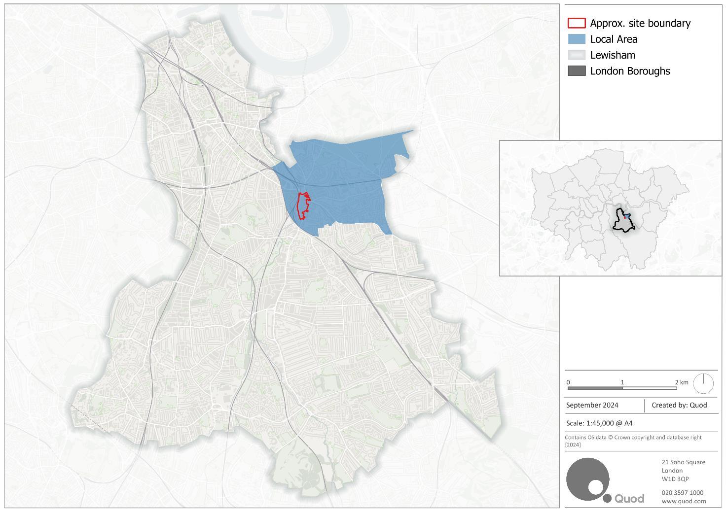
Health Baseline
4.3 Table 4 1 summarises the current health profile for residents of the Local Area and LBL, alongside regional and national averages. The table has been split into three main baseline sections: health outcomes, risk factors and wider determinants.
Figure
Context Map
4.4 Most of the data in Table 4 1 is extracted from OHID21, LBL’s Health Profile22, OHID Local Health (2022) and OHID Health Outcomes Framework data (2022), supported by ONS, 2021 Census and Sports England23 data.
4.5 Most datasets use indicators based on a standardised population number (generally per 100,000 population), or as a percentage of the whole population. Measurements have been specified throughout for clarity.
4.6 Data for some of the health indicators presented in Table 4.1 is not available at ward level or regional levels so there are some instances where information is not provided for the Local Area or London.
4.7 The data presented in Table 4.2 is extracted from the 2021 Census which is available at ward level.
Outcomes
Expectancy at Birth (upper age band 90+) (2016 – 2020)
Under 75 mortality rate: cardiovascular disease (directly standardised rate per 100,000) (2021)
Under 75 mortality rate: cancer (directly standardised rate per 100,000) (2022)
Under 75 mortality rate: causes considered preventable (directly standardised rate per 100,000) (2022)
Under 75 mortality rate: respiratory disease (directly standardised rate per 100,000) (2022)
21 Public Health England, 2022. Local Health. Available at: https://fingertips.phe.org.uk/profile/local-health
22 Office for Health Improvement & Disparities, Local Authority Health Profiles
23 Sports England, 2020. Active Lives Survey 2019/20
Table 4.1: Health Profile Summary
Suicide Rate (per 100,000 population aged 10+) (20202022)
Risk Factors
Obese children (aged 10-11 years) (2022/23)
Adults (aged 18+) classified as overweight or obese (2022/23)
Smoking prevalence in adults (current smokers) (GP Patient Survey) (2022)
Physically active adults (150+ mins moderate intensity activity per week) (2022/23)
Depression: Prevalence in adults aged 18+ (2022/23) (%)
Fuel poverty (2022) ‘low income, low energy efficiency methodology’
Wider Determinants
Violent Crime (violent offences per 1,000 population) (2022/23)
Killed and seriously injured on roads (crude rate per billion vehicle miles) (2022)
Children in absolute low income families (under 16s) (living in households with incomes below 60% of the median in that year) (under 16s) (2022/23)
Homelessness: households in temporary accommodation (per 1,000) (2022/23)
Health Indicator
Air pollution: fine particulate matter (concentration of PM2.5) (2022)
Fraction of mortality attributable to particulate air pollution (deals from all causes in those aged 30+) (2022)
The percentage of the population exposed to road, rail and air transport noise of 65dB(A) or more during daytime (2016)
The percentage of the population exposed to road, rail and air transport noise of 55dB(A) or more during the night-time (2016)
Table 4.2: Self-Reported Health (2021 Census Summary)
Health Indicator
Self-reported Health
‘Very good’ and ‘good’ (% of all residents that report their health to be ‘very good’ or ‘good’)
‘Bad’ and ‘Very bad’
Long Term Health Problem/Disability
Disabled under the Equality Act: Dayto-day activities limited a lot
Disabled under the Equality Act: Day-
Lewisham Central Blackheath (Lewisham)
to-day activities limited a little Not disabled under the Equality Act: Has long term physical or mental health condition but day-to-day activities are not limited
Health Outcomes
4.8 When assessing life expectancy for males, Blackheath ward (pre-2022 definition) is recorded to have a higher life expectancy at 81.2 years when compared to life expectancy in both Lewisham Central (78 years, pre-2022 definition), LBL (79 years) and England (79.5 years). This was similar for male life expectancies, with Blackheath ward (87.3 years, pre-2022 definition) also recorded to have a higher life expectancy when compared to Lewisham Central (82.4 years, pre-2022 definition), LBL (83.5 years) and England (83.2 years). Blackheath ward was also recorded to have the highest life expectancies for both men and women when compared to all other wards within Lewisham.
4.9 The 2021 Census asked residents to self-assess their health, and results suggest that the proportion of the Local Area residents report their health to be ‘very good’ or ‘good’ (87%) is greater than proportions in LBL and London, the London and England.
4.10 The proportion of individuals that are disabled under the Equality Act which limited day-to-day activities a little or a lot was recorded to be 13% in the Local Area, which lower equal to the proportion at the local authority, regional and national levels.
4.11 According to the Office for Health Improvement and Disparities, under 75 mortality rates for all causes considered preventable, cardiovascular disease, cancer and respiratory disease are higher across the LBL when compared to rates at the regional and national levels.
Wider Determinants of Health and Risk Factors
4.12 Data from PHE Fingertips suggests there to be a high proportion of overweight people across LBL, with the proportion of obese children in LBL (40.8%) being greater than proportions at the regional (38.8%) and national (36.6%) levels, and the proportion of overweight/obese adults being greater in LBL (62.9%) when compared to the regional level (57.2%).
4.13 In addition to this, smoking prevalence is greater within LBL (15.3%) when compared to London (11.7%) and England (12.7%).
4.14 The rate of violent crime within the LBL (29.9 per 1,000 population) is lower than the rate at the national level (34.3 per 1,000 population) but greater than the rate within London (27.5 per
1,000 population), with the LBL having the 13th highest rate of violent crime when compared to other local authority areas in London.
4.15 The fraction of mortality attributable to particulate air pollution in individuals over 30 within LBL (7.0%) is marginally lower than the rate at the regional level (7.1%) but higher than the rate in England (5.8%). The percentage of the population exposed to road, rail and air transport noise of 65dB(a) (12.0%) was recorded to be greater than national level (5.5%) but marginally lower than the regional level (12.1%), while the proportion of population exposed to road, rail and air transport noise of 55dB(a) is greater in the LBL (16.0%) when compared to levels at the regional (15.8%) and national scales (8.5%).
Mental Health
4.16 Mental health and physical health are heavily intertwined, with poor physical health being strongly linked with mental health problems. Individuals that suffer from substance misuse, obesity, smoking and cancer are more likely to experience mental health problems.
4.17 Poor mental health is also associated with socio-economic disadvantage and poverty, with homeless individuals or individuals within institutional settings being more likely to experience mental health issues.
4.18 The suicide rate in LBL is low when compared with both the regional and national averages, with the LBL having the 20th lowest suicide rate when compared to all districts in England. Furthermore, 10.9% of LBL patients over the age of 18 were recorded to have depression, which was greater than the regional proportion but lower than the national proportion.
4.19 In addition to this, data from the ONS annual personal well-being estimates for 2022-2324 shows Lewisham to have a mean anxiety score (out of 10) of 3.58 which is higher than both the London (3.34) and England (3.24) levels.
Health Deprivation
4.20 The Government’s Index of Multiple Deprivation (IMD) (2019)25 measures relative deprivation by combining indicators to establish a single deprivation score for each neighbourhood (Lowerlayer Super Output Area, LSOA26) across England.
4.21 All LSOAs are ranked relative to one another according to their level of deprivation.
4.22 These indicators are divided among seven domains of deprivation, outlined as follows:
▪ Income deprivation;
▪ Employment deprivation;
24 ONS, 2023. Headline estimates of personal well-being from the Annual Population Survey (APS): by countries, regions, counties, local and unitary authorities, year ending March 2012 to year ending March 2023
25 Ministry of Housing, Communities and Local Government (2019) The English Indices of Deprivation 2019: Statistical Release
26 LSOAs are statistical geographic areas based on population size. The minimum population for a LSOA is 1,000 residents, or 400 households.
▪ Education, skills, and training deprivation;
▪ Health deprivation and disability;
▪ Crime;
▪ Barriers to housing services; and
▪ Living environment deprivation.
4.23 Lewisham is the 63rd most deprived Local Authority in England, falling within the 10% to 20% most deprived areas in England.
4.24 The health deprivation and disability domain measures “the risk of premature death and the impairment of quality of life through poor physical or mental health”. Measures of health include morbidity, disability and premature mortality.
4.25 Figure 4.2 below shows the relative levels of deprivation directly related to health in LBL. The Site does not fall within an LSOA that is in the 30% most deprived areas in England for health. Despite this, there are some clusters directly to the south of the Site that fall amongst the 10% and 20% most deprived areas in England for health.

Figure 4 2 - Indices of Multiple Deprivation: Health Domain
Health Priorities
4.26 Based on the Health Baseline Profile set out above, and review of the local policy, the following have been identified as health priorities in this neighbourhood to inform this assessment:
▪ Tackling obesity in children and adults (with the LBL having higher proportions of obese adults and children when compared to London averages);
▪ Encouraging local residents to make healthy lifestyle choices (with the prevalence of smoking within the LBL being greater than proportions at the regional and national levels);
▪ Promoting mental wellbeing (with LBL having the 7th highest prevalence of depression when compared to all other local authorities in London);
▪ Increasing the availability of high quality and affordable housing (in line with policy objectives for affordable homes and reducing poor quality accommodation);
▪ Improving access to the physical environment including social infrastructure and green space (which will ensure that local residents have access to the resources and facilities to make healthy choices);
▪ Improving transport, accessibility and road safety (ensuring that local residents have access to high quality transport links and safe routes, which will encourage the use of sustainable transport methods);
▪ Reducing crime and anti-social behaviour (as the rate of violent crime is higher than rates at both the regional and national levels); and
▪ Working to prevent long-term health conditions (with mortality rates for cardiovascular disease, respiratory disease and all other causes considered to be preventable in the LBL being higher than both regional and national averages)
Health
Tackling obesity and related lifestyle choices
Encouraging local residents to make healthy lifestyle choices
Access to healthy food
Accessibility and active travel
Access to health and social care and other social infrastructure
Access to health and social care services and other social infrastructure
All health pathways but in particular:
Promoting mental wellbeing
Social cohesion and inclusive design
Access to health and social care services
Overweight people
People with pre-existing health conditions, disabilities or co-morbidities including mental or physical conditions that affect propensity to exercise
Overweight and obese
Groups that are potentially more prone to isolation including:
People with disabilities
People with long term health conditions
Older people
Table 4 3: Health Priorities, Health Pathways and Vulnerable Groups
Health Priority Relevant Health Pathway Vulnerable Groups
Increasing the availability of high quality and affordable housing
Improving access to the physical environment, including social infrastructure and green space
Housing design and affordability
Social cohesion and inclusive design
Housing design and affordability
Access to health and social care and other social infrastructure
Social cohesion and inclusive design
Access to open space and nature
Air quality, noise and neighbourhood amenity
Climate change
Improving transport and accessibility and road safety
Accessibility and active travel
Social cohesion and inclusive design
Young and old (issues around the availability of suitable housing for both young and old people)
Low-income (issues around the affordability of high quality housing)
Homeless people (issues around accessing social infrastructure and information on how these facilities can be accessed)
Disabled people
People with pre-existing health conditions (equipping facilities with the tools needed to cater for people with pre-existing conditions)
Young and old people
Low-income people
Children (safety issues for young children around busy roads)
Older people (accessibility issue; difficulty moving within the local area)
Disabled (accessibility issues; potential barriers from demolition and construction activities that impact accessibility)
Reducing crime and anti-social behaviour
Working to prevent long-term health conditions
Crime reduction and community safety
Access to healthcare services and other social infrastructure
Social cohesion and inclusive design
Fear and perception of crime among vulnerable groups including: Women
Young and Old Disabled
Long term health conditions (continued access to healthcare services)
5 Health Pathways and Health Impact Assessment
Engagement
5.1 Engagement with the local community, including residents, workers and stakeholders, is important to understanding the health risks prevalent in the area and the local needs. Consultation empowers local communities to clearly set out where they feel improvements are required to support them or where benefits could be maximised. The process of engagement helps inform the design progression shape a place that reflects community aspirations.
5.2 Engagement and consultation has been ongoing for the past three years with the project team identifying a range of affected community groups, businesses and other stakeholders. Stakeholders and community groups were invited to an extensive programme of consultation including: creation of a group of Design Champions, Surveys (written, online and in-person), Public Consultation events including e-gaming, Themed public workshops, Existing Site Tours and Engagement with local youth group Circle Collective. For more information, please refer to the Statement of Community Involvement
Housing Design and Affordability (Identified Priority)
Potential Health Pathways
5.3 Increasing the availability of high quality and affordable housing has been identified as a local health priority.
5.4 Access to good quality housing is essential for public health, particularly for vulnerable groups such as the elderly or young people, or low-income groups. The Marmot Review (2010) identified that bad housing conditions – which also include factors such as homelessness, temporary accommodation, overcrowding, insecurity, and housing in poor physical conditions – constitute a risk to health, and this is most likely to affect the more vulnerable groups in society. The Marmot Review 10 Years On (2020) report also notes the direct impact of poorquality housing on mental health including stress resulting from affordability issues and financial strain.
5.5 Several housing factors can impact health causing mental health disorders, physical illness and accidents; these factors include:
▪ Poor choice of housing location (poor access to local services);
▪ Design and orientation;
▪ Poor sanitation;
▪ Unfit living conditions such as excessive damp, poor insulation;
▪ Unhealthy environmental quality; and,
▪ Overcrowding.
5.6 As set out within Table 4 1, the rate of households in temporary accommodation within LBL is 19.8 per 1,000 households which compares to a rate of 15.9 within London and 4.2 within England.
Health Impact Assessment
5.7 This section responds to the following questions outlined in HUDU’s HIA Guidance that are relevant to this application:
▪ Does the proposal seek to meet Building Regulation requirement M4 (2)?
▪ Does the proposal address the housing needs of older people, i.e. extra care housing, sheltered housing, lifetime homes and wheelchair accessible homes?
▪ Does the proposal include homes that can be adapted to support independent living for older and disabled people?
▪ Does the proposal promote good design through layout and orientation, meeting internal space standards?
▪ Does the proposal include a range of housing types and sizes, including affordable housing responding to local housing needs?
▪ Does the proposal contain homes that are highly energy efficient (e.g. a high SAP rating)?
Table 5 1: Housing Design and Affordability - Health Impact Assessment
Housing Design and Affordability Details/Evidence
Relevant Y As highlighted within the Masterplan Design & Access Statement, the Proposed Development will deliver 119 new homes and 445 co-living rooms within the detailed phase of development, and up to 1,600 new homes and 661 student accommodation rooms/studios as part of the outline phase of development (including affordable housing). The residential, co-living and student accommodation will be accompanied with both communal and private landscaped amenity space.
The proposals include a wide range of housing types and sizes including 1-, 2- and 3bedroom apartments, with 46 homes in Building N1 and 11 homes in Building N2 set to come forward as wheelchair accessible, equating to 10% of the all accommodation provided in the detailed phase (and meeting Building Regulation requirement M4 (3)(2)(A)). 10% of all homes set to be provided as part of the outline scheme will also be M4(3)(2)(A) compliant, with all other dwellings complying with Building Regulation M4(2).
The proposals do not include provision of extra care housing.
The proposal promotes good design by setting residential entrances back from the street providing sheltered access and a degree of separation from the street. As a result of the nature of the multi-level landscape approach, residential plots will have more than one entrance, with primary entrances located at the ground floor where possible to ensure 24hour access and natural surveillance from building receptions is provided.
Housing Design and Affordability Details/Evidence
Delivery of housing on-site would have positive health benefits, helping to reduce health inequalities among more vulnerable groups, such as those on low income. ES Volume 1, Chapter 15: Socio-Economics assessed the Proposed Development’s housing delivery impact as being significant and moderate beneficial at the district level.
Recommendation/ Mitigation
None required
Access to Healthcare Services and Other Social Infrastructure
Potential Health Pathways
5.8 Improving access to the physical environment, including social infrastructure and green space has been identified as a local health priority.
5.9 Public services and community infrastructure are important in supporting strong, sustainable and cohesive communities. Good access to public services including health services, education and community facilities has a positive effect on human health, without which people can be at risk of isolation and lack of support required to maintain a healthy lifestyle. Underprovision can also lead to longer travel times, increasing transport requirements and potentially increasing local pollution.
5.10 There is a range of facilities servicing the local community including schools and GP surgeries. The Lewisham Care Partnership (LCP) is within a 1km catchment of the Site and the nearest urgent care unit (UCC) is Lewisham Hospital (just over 900m from the Site).
Health Impact Assessment
5.11 This section responds to the following questions outlined in HUDU’s HIA Guidance that are relevant to this application:
▪ Does the proposal retain or re-provide existing social infrastructure?
▪ Does the proposal assess the impact on health and social care services and have local NHS organisations been contacted regarding existing and planned healthcare capacity?
▪ Does the proposal include the provision, or replacement of a healthcare facility and does the facility meet NHS requirements?
▪ Does the proposal assess the capacity, location and accessibility of other social infrastructure, e.g. primary, secondary and post 19 education needs and community facilities?
▪ Does the proposal explore opportunities for shared community use and co-location of services?
Table 5 2: Access to Health and Social Care Services and other Social Infrastructure - Health Impact Assessment
Access to Health and Social Care Services and other Social Infrastructure Details/Evidence
Relevant Y The existing Site does not currently accommodate any social infrastructure.
ES Volume 1, Chapter 15: Socio-Economics estimates the Proposed Development will house 769 residents in the detailed phase (inc. 556 in Co-Living) and 3,586 residents in the outline phase (inc. 661 in student accommodation). This equates to demand for the equivalent of 2.1 FTE GPs, falling to 1.8 FTE GPs when excluding students, who have relatively low healthcare demands.
A baseline analysis of local primary healthcare is provided in the ‘Healthcare’ section of ES Volume 1, Chapter 15: Socio-Economics. This suggests that there is some limited GP capacity locally (within 1km catchment of the Site), with the average patient list size per FTE GP being lower in than the London average. In addition, local facilities are still accepting new patients and in the context of the overall list size of these practices, the potential uplift in demand is negligible.
ES Volume 1, Chapter 15: Socio-Economics estimates the Proposed Development will be home to 104 primary aged children and 39 secondary aged children.
As outlined within the ‘Primary Education (15.7.28 – 15.7.37)’ of ES Volume 1, Chapter 15: Socio-Economics, the current combined surplus capacity of the schools within 1km of Site is equal to 17%. It is expected that the 104 primary aged children can be accommodated in the local primary school network with no adverse effect on that network.
The assessment of secondary school capacity was considered at the Borough level. As outlined within the ‘Secondary Education (15.7.37 – 15.7.44)’ of ES Volume 1, Chapter 15: Socio-Economics, baseline analysis shows there is currently 8% surplus capacity across LBL secondary schools. It is expected that the 39 secondary aged children can be accommodated within the local secondary school network with no adverse effect on that network.
As highlighted within the Design & Access Statement, the proposals include a new community music venue that will anchor an evening economy and improve the overall town centre offer. The Proposed Development is also set to provide a minimum of 1,751
Access to Health and Social Care Services and other Social Infrastructure Details/Evidence
GEA sqm of community and cultural floorspace as part of Plots M1 and MV which will anchor the centre of the multi-layered landscape and provide the music venue
Recommendation/ Mitigation None required
Access to Open Space and Nature
Potential Health Pathways
5.12 Improving access to the physical environment, including social infrastructure and green space has been identified as a local health priority.
5.13 Numerous studies point to the direct benefits of green space to both physical and mental health. Green space has been associated with a decrease in health complaints, improved mental health, reduced stress levels, and the perception of better general health. The provision of open space also has indirect benefits by encouraging social interaction and providing space for physical activities and improving air quality.
5.14 Accessible amenity space has been linked with environments that are more walkable, with aesthetics and street connectivity influencing patterns of use. Physical activity, which is more likely to be undertaken if open space or improved linkages are provided, plays a key role in the prevention of specific diseases/health issues that include cardio-vascular disease, depression, and obesity.
5.15 As set out within Planning Policy Framework, access to open space and nature is closely linked to the health priority of ‘healthy lifestyles’ due to its multiple functions in providing space for recreation, tranquillity and relaxation, which can have a large impact on people’s ability to adopt healthier habits, including exercise.
5.16 The Site has good access to a number of open spaces, with closest open space to the Site being Cornmill Gardens which is less than 50m to west of the Site and accessed via a walkway under the railway. The Site is also in close proximity to Hilly Fields Park and Blackheath Open Space, which are both Metropolitan Open Land (MOL). The LBL Open Space Strategy27 states that the Site does not fall in an area of playspace deficiency but falls within an area of deficiency for local, small and pocket parks.
Health Impact Assessment
27 LBL, 2020. Parks and open spaces strategy 2020–2025
5.17 This section responds to the following questions outlined in HUDU’s HIA Guidance that are relevant to this application:
▪ Does the proposal retain and enhance existing open and natural spaces?
▪ In areas of deficiency, does the proposal provide new open or natural space, or improve access to existing spaces?
▪ Does the proposal provide a range of play spaces for children and young people?
▪ Does the proposal provide links between open and natural spaces and the public realm?
▪ Are the open and natural spaces welcoming and safe and accessible for all?
▪ Does the proposal set out how new open space will be managed and maintained?
Table 5.3: Access to Open Space and Nature - Health Impact Assessment
Access to Open Space and Nature
Details/Evidence
Relevant Y The existing Site does not comprise any existing open or natural space.
The Proposed Development will provide a series of new landscape character areas offering open spaces and access to nature for residents. As set out within the Development Specification, the Proposed Development is set to provide new open and public realm space of at least the following quantums:
- The Park (5,255 sqm)
- Northern Square (3,360 sqm)
- Eastern Terrace (1,970 sqm)
- New Model Market (1,300 sqm)
The provision of these spaces will address the areas current deficiencies in local, small and pocket parks. The site will also encompass a holistic green approach which references the historic landscape character of the area and creates important links between open space and public realm spaces.
The concept for project and landscape design is to create a sequence of meadow spaces called Lewisham Meadows, which will be biodiverse and capture significant amounts of carbon, in addition to having atmospheric qualities that will go through vibrant changes of colour and textures at different times of year.
New routes through the Site will have public spaces at their intersections, while the multi-level, public nature of Lewisham meadows, along with the meadow planting approach, will create a unique and dynamic experience. The Site will also create links between new open spaces and existing local infrastructure such as Lewisham Gateway, the Sculpture Park, Cornmill Gardens and Lewisham High Street.
The multiple levels of landscape will also aid connectivity between open space and the public realm, with the Park set to connect the Arrival Space, the High Street and
Access to Open Space and Nature Details/Evidence
Lewisham Market, and steps at the park set to provide a multi-level experience. The cohesive landscape approach will knit the different public realm areas with existing areas from outside of the Site.
The Proposed Development will concentrate new public space that is provided in order to create an accessible, safe and unified destination for Lewisham. The Eastern Square will be an elevated public realm space that focuses on providing space for young people, with active food and beverage-led frontages and bespoke structures ensuring that users of the space feel safe and welcome.
The Northern Square will be an urban square that consists of spill out zones, seating areas and a central gathering area, with water features. Both the Northern Square and the Podium Park will be monitored by CCTV, with a security team set to monitor these spaces on foot.
A comprehensive maintenance and management strategy will be required by the estate management team to ensure the quality of spaces is consistent throughout the phased construction, completion and project lifespan of the entire masterplan.
Hard landscape
A maintenance and management regime must take into account the expected footfall of various town centre users, servicing requirements and vehicle movements. This will inform the level of resource and equipment that will be needed to repair and replace the hard landscape, which includes seating, lighting fixtures, balustrades and paving. Cleaning and maintaining hard landscape elements (to suppliers’ recommendations) will in theory maximise the lifespan before the end of their product lifecycle. By maximising lifespan and therefore reducing the rate of replacement, the benefit is not solely practical but also environmental, by reducing the embodied carbon of the project.
Soft landscape
A successful planting design is integral to the identity and place-making principles of Lewisham Meadows. A healthy and thriving soft landscape will depend on gardeners and groundsmen that are highly skilled in horticultural understanding and management.
As with hard landscape, the value in maintaining the planting design goes beyond place-making and practicality. Rather, it is vital that trees, shrubs and plants can live and thrive for as long as possible to provide maximum environmental benefits (biodiversity value, green infrastructure, pollutant capture, carbon capture, urban cooling, SUDS) in addition to reducing replacement, and therefore embodied carbon.
The Design and Access Statement outlines that a total of 125 sqm of playspace will be provided as part of the detailed phase of the Proposed Development and up to 2,356sqm of playspace will be delivered as part of the outline phase of the Proposed
Access to Open Space and Nature Details/Evidence
Development. This proposed provision of playspace is in line with the GLA’s Play and Informal Recreation SPG (para 4.31)28 .
Recommendation/ Mitigation None required
Air Quality, Noise and Neighbourhood Amenity
Potential Health Pathways
5.18 Controlling noise impacts has been identified as a local health priority.
5.19 Air quality has implications for long-term health. Dust and emissions from transport and construction processes are the main potential source of pollutants associated with development. Poor air quality is associated with negative health outcomes, such as chronic lung disease, heart conditions and asthma, particularly among children.
5.20 Planning and development influence land use and, therefore, may influence the quantity and types of emissions produced – either reducing or increasing them. Mitigation measures, including the provision and design of open spaces, tree planting, transport strategies and the use of technology to reduce and capture emissions may be used where appropriate.
5.21 The Air Quality Assessment identifies that the Proposed Development lies within a declared an Air Quality Management Area (AQMA) and an Air Quality Focus Area (AQFA), which are designated for exceedances of PM10 daily mean concentrations and NO2 annual and hourly mean concentrations. Within the construction phase, a qualitative assessment of the potential impacts on local air quality from construction activities is undertaken. An operational phase exposure assessment was also undertaken, with ADMS-Roads used to predict NO2, PM10 and PM2.5 concentrations across the Site at heights/locations representative of future relevant exposure.
5.22 Noise and vibration also have links to the health of a population, particularly in places where people live or work in close proximity to sources of noise and vibrations. Very high noise levels can have direct impacts on health (hearing loss or tinnitus) but there “should be no risk” of these levels of noise from environmental factors29. Lower levels (nuisance or annoyance
28 GLA, 2012. Shaping Neighbourhoods: Play and Informal Recreation – Supplementary Planning Guidance (SPG)
29 Noise exposure level beyond 80 dB during 40 years of working a 40 hour work week can give rise to permanent hearing impairment. Given that environmental exposure to noise is much lower than these levels and that noise-related hearing impairments are not reversible, the GDG considered that there should be no risk of hearing impairment due to environmental noise and considered any increased risk of hearing impairment relevant. WHO, 2018, Environmental Noise Guidelines for the European Region p. 23
levels) have indirect effects including through stress-related illness and disturbances in sleep. These nuisance levels did not affect people equally. Nuisance and annoyance can have higher or lowerrelative importance assigned bythose affected by them. Such importance varies within and across populations; and this importance or variability can be uncertain30. As such it is challenging to predict with any certainty the degree to which nuisance and annoyance from noise will affect people at an individual level. Where noise is a potential factor in a health impact assessment it is appropriate to consider effects at a population level separately to those at an individual level.
5.23 The Noise and Vibration Assessment sets out the current average and minimum daytime and night-time noise levels at the surrounding road networks near the Site. Receptors of relevance to this assessment include residential dwellings along Lewisham High Street and Lewis Grove, in addition to residential dwellings at Mill Apartments and Riverdale House, St Saviour’s Church and Lewisham Gateway. The closest sensitive receptors are the new dwellings within occupied phases of the Masterplan, which are situated 10m from the construction activity.
Health Impact Assessment
5.24 It is anticipated that the demolition and construction of the Proposed Development will last 10 years, taking place between Q2 2026 and Q2 2036. Peak construction will take place in 2030. The earliest year that any part of the proposed development is set to be operational is expected to be 2028, with the earliest year of completion being 2036.
5.25 This section responds to the following questions outlined in HUDU’s HIA Guidance that are relevant to this application:
▪ Does the proposal minimise construction impacts such as dust, noise, vibration, and odours?
▪ Does the proposal minimise air pollution caused by traffic and energy facilities?
▪ Does the proposal minimise noise pollution caused by traffic and commercial uses? Table 5 4:
ES Volume 1, Chapter 7: Air Quality describes the existing local air quality of the Site and reviews the air quality impacts during construction and operational phases including dust emissions from construction activities, emissions from construction phase non-road mobile machinery and traffic affecting local air quality receptors, exposure of future Site users to poor air quality and an assessment of Air Quality
Air Quality, Noise and Neighbourhood Amenity Details/Evidence
Neutral (ensuring that developments do not contribute to air pollution beyond permitted benchmarks).
Demolition and Construction
When assessing effects from the Construction Dust Assessment, the potential dust emission magnitude is expected to be large for demolition activities, construction and trackout, and medium for earthworks. In addition, the sensitivity of the surrounding area is high for dust soiling and medium for human health across all dust emission generating activities. As a result of this, the risk of dust soiling impacts is expected to be high for demolition, construction and trackout and medium for earthworks, while the risk of human health impacts are expected to be high for demolition, and medium for earthworks, construction and trackout.
In order to mitigate against these high-risk sites, the following mitigation measures have been recommended:
• General Communication – a stakeholder communications plan that includes community engagement before work commences on site, contact details of people accountable for air quality and dust issues on the Site Boundary and a Dust Management Plan (DMP) which may include measures to control emissions;
• Site Management – all dust and air quality complaints to be recorded, while exceptional incidents that cause dust/air emissions should be resolved and recorded in a logbook, and regular liaison meetings with other high risk construction sites should be held;
• Monitoring – daily onsite and offsite inspections and regular site inspections to monitor compliance with the Construction Management Plan/Demolition Management Plan (CMP/DMP);
• Site Preparation – planning the layout of the Site so that machinery causing activities are located away from receptors, erecting solid screen and barriers around dust generating activities, enclosing the Site where there is a high potential for dust production and removing materials that have the potential to produce dust from Site as soon as possible;
• Operating vehicle/machinery and sustainable travel – ensuring that all onroad vehicles comply with the requirements of the London Low Emission Zone and London Non Road Mobile Machinery (NRMM) standards, avoiding the use of diesel/petrol powered generators and introducing Construction Logistics and Travel Plans;
Air Quality, Noise and Neighbourhood Amenity Details/Evidence
• Operations – only using cutting, grinding or sawing equipment with suitable dust suppression, using enclosed chutes/covered skips, minimising drop heights from conveyors and ensuring equipment is readily available on Site to clean any dry spillages;
• Waste Management – avoiding bonfires and the burning of waste materials;
There are also measures specific to demolition, earthworks, construction and trackout which are detailed in Paragraph 7.9.20 of the ES Volume 1, Chapter 7: Air Quality. If these mitigation measures are adopted and adhered to, the residual effects of dust and particulate matter (PM) will be temporary, short-term and negligible (not significant).
As NRMM is expected to move around the Site over the duration of the construction period and emissions will be temporary in nature, there will be no long-term impacts on air quality for nearby receptors, resulting in a temporary, negligible effect (not significant)
When assessing construction traffic impacts on air quality, the impacts of increased emissions and construction traffic on both annual and hourly mean of NO2 and PM10 were reported to be negligible.
The assessment suggests that the highest predicted PM2.5 annual mean concentration in 2030 is 13.4µg/m3 which is lower than the current AQS objective, but higher than the Mayor of London’s target of 10µg/m3 by 2030. With the existing background concentrations being between 11.2µg/m3 to 11.6µg/m3 at modelled receptors, the predicted increase as a result of peak construction is a maximum of 0.1µg/m3. Consequently, the impact of the increased emissions on PM2.5 annual mean concentration is considered to be negligible.
Operational Phase
When looking at air quality impacts within the Operational Phase, annual mean concentrations of NO2 and PM10 are below relevant AQS objectives, with the Proposed Development not predicted to introduce new receptors into an area of known poor air quality. As a result of this, the residual effect of the Proposed Development on NO2 and PM10 concentrations is expected to be negligible during the operational phase.
The Site’s heat demand is expected to be met through air source heat pumps which will be assumed to have zero-heat related NOX emissions as stated within the Mayor of London’s Air Quality Neutral guidance31. With back up diesel generators only set to
31 More information on what it means to be Air Quality Neutral can be found in the following London Plan Guidance: Mayor of London (2023). London Plan Guidance: Air Quality Neutral https://www.london.gov.uk/sites/default/files/2023-02/Air%20Quality%20Neutral%20LPG.pdf
Air Quality, Noise and Neighbourhood Amenity Details/Evidence
be installed for life safety purposes or routine testing/maintenance, and the Proposed Development set to be car-free (except from blue badge parking spaces), the Proposed Development is set to be Air Quality Neutral with regard to both building and transport emissions.
Noise and Vibration
ES Volume 1, Chapter 6: Noise and Vibration provides a summary of the likely significant effects of the Proposed Development on Site and the surrounding area in terms of Noise and Vibration matters. This chapter assesses the noise and vibration impacts on existing noise receptors and early occupied phases within the Proposed Development, the Site’s suitability for residential development with regards to noise and noise effects during the operational phase of development (including changes in noise associated with road traffic, the new building services plant and operational activity within the Proposed Development).
The chapter identifies eleven sensitivity receptors comprising nearby existing residential uses, St Saviour’s Church and new dwellings within the occupied phases of the masterplan.
Demolition and Construction
When assessing the potential impacts of noise from demolition and construction activities within Phase 1A, the majority of demolition and construction activities will result in a negligible to low impact magnitude, while minor negative impacts are predicted at R6 (Residences at 110-118 Lewisham High Street (above shops)) and R9 (Lewisham Gateway Phase 2), and moderate negative effects are predicted at R7 (Residences at Metro Apartments (86-92 Lewisham High Street) and 90-94A Lewisham High Street (above shops)) and R8 (Residences at 50-70 Lewisham High Street (above shops)).
Similarly, when assessing the potential impacts of noise from demolition and construction activities from the remaining phases, the majority of demolition and construction activities will result in a negligible to low impact magnitude on receptors, while minor negative effects are predicted at receptors R1 (Residential dwellings at Mill Apartments and Riverdale House), R2 (Residential apartments at 193 Lewisham High Street (above shops)) and R10 (St Saviour’s Church), and moderate negative effects are predicted at R11 (New dwellings within occupied phases of the Masterplan).
It is important to note that the phased nature of the works would mean that impacts on individual existing properties would not be felt throughout the entire duration of the ten year construction phase, with impacts being shorter and temporary for periods
Mitigation measures will be employed including adhering to ‘Best Practicable Means’ (BPM) which to reduce noise from construction related activity of significant impact in
Air Quality, Noise and Neighbourhood Amenity Details/Evidence
addition to activity that was found to be of a lower impact. The final Construction Management Plan (CMP) will also act as mitigation against these significant effects, with the CMP expected to include confirmation of Site working hours, substitution of noisy plant with quiet alternatives, provision of enclosures/acoustic barriers around noisy plant, regular maintenance of plant to minimise noise, clear communication between the contractor and local residents, and the use of just-in-time deliveries to reduce the duration which receptors are exposed to noise from construction traffic.
Receptors
R7 (Residences at Metro Apartments (86-92 Lewisham High Street) and 90-94A Lewisham High Street (above shops)) and R8 (Residences at 50-70 Lewisham High Street (above shops)) are located less than 10m from the Proposed Development during Phase 1A, with the assessment suggesting that here may be potential for high levels of vibration at these receptor locations. This will result in a negligible to moderate negative (significant) effect, which will be mitigated against using vibration measures set out within the CMP, including clear communication lines with residents, vibration monitoring and maintaining the equipment used.
Operational Phase
When assessing the changes in noise associated with operational road traffic from the Proposed Development, with there set to be an overall reduction in traffic movements for all assessed road links, the effect is assessed to be negligible (not significant) during both ‘Phase 1A’ and the ‘Fully Completed’ development scenarios.
Once operational, the Proposed Development includes a building services plant which is likely to include air handling plant, residential heating and cooling, commercial heating and cooling, and emergency plant. The assessment of noise from the building services plant is based on setting limiting rating noise levels that future plant will need to adhere to as a result of the current state of design. If these limits are secured through a planning condition, noise from the building services plant will result in a minor negative (not significant) effect at all noise sensitive receptors.
Despite the impact assessment concluding that noise from building services plant would be controlled to limiting noise criteria, noise control limits will be needed as mitigation to ensure that limits are adhered to, including selecting low noise equipment and the use of physical noise control measures such as sound attenuators and attenuation packs.
When looking at noise impacts on commercial uses, the assessment of the music venue breakout suggests that there will be a medium noise impact at receptor R3, resulting in a moderate negative effect. The proposal will minimise noise pollution by producing noise management plans as mitigation measures, which will include a combination of physical noise control measures and management measures. Façade specifications will also need to be developed to limit noise break-out from the music
Air Quality, Noise and Neighbourhood Amenity Details/Evidence
venue to low levels. Sound reduction performance may also be required which could include the blocking up of existing windows, and acoustic rated noise linings.
The Site Suitability assessment, which considers the suitability of the Site for residential development (as proposed), suggests that it would be possible provide suitable alternative external amenity space within the Proposed Development in terms of noise
Recommendation/ Mitigation
Implementation of and adherence to the Construction Management Plan (CMP). Implementation of and adherence to the Dust Management Plan (DMP)
Good general communication, site management, monitoring, site preparation operations and waste management within the demolition and construction phase Mitigation measures specific to demolition, earthworks, construction and trackout as set out in Paragraph 7.9.20 of the ES Volume 1, Chapter 7: Air Quality
Adopting BPM to control noise from construction works and a risk assessment CFA piling to reduce disturbance to sensitive receptors
Low emission plant machinery, enclosures and local screening
Accessibility and Active Travel
Potential Health Pathways
5.26 Improving transport and accessibility and road safety has been identified as a local health priority.
5.27 Traffic or transport impacts may have positive or negative effects on health. Planning and development may result in effects that improve or reduce access to services, including health services, and to employment. Development may provide or remove access to public transport, walking and cycling routes that support active lifestyles.
5.28 Increased traffic from large vehicles associated with demolition and construction may also pose indirect health effects through fear and intimidation to pedestrians and cyclists. Fear would impact on health by increasing stress, while intimidation may dissuade individuals from walking or cycling and thus making healthy lifestyle choices.
5.29 Accidents and road safety directly impact health, where traffic volumes could potentially have a detrimental effect on highway safety through increased opportunities for conflict.
5.30 A full transport baseline is set out in the Transport Assessment (TA) submitted alongside the Application. The Site has a public transport accessibility level (PTAL) ranging from 6b, which demonstrates an ‘excellent’ accessibility level to public transport.
5.31 Accessibility and active travel is identified in Section 3 as a relevant health pathway with respect to the health priorities of air quality and healthy lifestyles. This is because a ‘modal shift’ with less reliance on cars, encouraging and promoting sustainable transport including
cycling, walking and other forms of active travel could tackle multiple health considerations –including illness related to air pollution and illness related to physical inactivity.
Health Impact Assessment
5.32 This section responds to the following questions outlined in HUDU’s HIA Guidance that are relevant to this application:
▪ Does the proposal address the ten Healthy Street indicators?
▪ Does the proposal prioritise and encourage walking (for example through the use of shared spaces)?
▪ Does the proposal prioritise and encourage cycling, for example by providing secure cycle parking, showers and cycle lanes?
▪ Does the proposal connect public realm and internal routes to local and strategic cycle and walking networks?
▪ Does the proposal include traffic management and calming measures to help reduce and minimise road injuries?
▪ Is the proposal well connected to public transport, local services and facilities?
▪ Does the proposal seek to reduce car use by reducing car parking provision, supported by the controlled parking zones, car clubs and travel plans measures?
▪ Does the proposal allow people with mobility problems or a disability to access buildings and places?
Table 5 5: Accessibility and Active Travel - Health Impact Assessment
Relevant Yes As highlighted within the Transport Assessment, the design of the Proposed Development has taken the Healthy Streets indicators into account by providing an urban realm within the Site that links seamlessly with the existing urban realm, enhancing routes through the Site and to Molesworth Street and ensuring that public areas are illuminated and well overlooked. The Proposed Development has also been designed to be car free, with the exception of blue badge parking provision.
The proposal will prioritise walking through the provision of key pedestrian areas for resting and play, in addition to a cohesive landscape that knits different public realm areas with existing areas outside of the Site. The removal of the existing multi-storey car park will lower levels of motorised traffic and encourage people to take alternative modes of transport to the Site, including walking.
The vision for the Proposed Development is for space to be dominated by pedestrian movements, creating an active environment and a sense of place. The proposals include several north-south pedestrian routes through the Site which enable shoppers, residents, employees and visitors to travel from Lewisham Station and Lewisham Gateway to the north, through the centre of the Proposed Development towards Lewisham High Street. These
Accessibility and Active Travel Details/Evidence
routes will create a more welcoming environment where people feel safe and have places to rest.
East-west pedestrian routes will open the centre of the Proposed Development out to the High Street and Molesworth Street, allowing for connections to the wider transport networks. The central east-west route will enable users of the bus stops on Molesworth Street or the car park to have better access to retail units along Lewisham High Street and Lewisham Market, in addition to connecting future residents of the Site to amenities along the high street. The northern east-west route will involve the relocation of the existing staggered toucan crossing to provide a new straight-across toucan crossing on Molesworth Street, which will provide pedestrians with a more efficient route to Cornmill Garden Playground, River Mill Park, Prendergast Vale School, and Hilly Fields.
The Proposed Development will also use and enhance good cycling infrastructure that is currently in place surrounding the Site, with the proposed toucan crossing on Molesworth Street set to reduce severance on National Cycle Route (NCR) 21, improving accessibility to key destinations.
The northern route will provide both a pedestrian and cycle connection between Lewisham Station and Lewisham High Street via the northern square. Cyclists will be able to travel on the southern servicing route and the east-west route in the southern area of the Proposed Development, facilitating a connection from Molesworth Street to Lewisham High Street for cyclists.
Building N1 will provide a cycle lift which will provide access to the cycle store, located on the first floor. The southern access to the eastern block of N1 directs pedestrians to a building core, via a corridor which connects the to the lift and staircase lobby, providing access to the cycle store.
Phase 1a will include the provision of 536 long-stay cycle spaces (336 co-living spaces and 200 build-to-rent spaces) and 48 short-stay cycle spaces (12 co-living spaces, 4 build-to-rent spaces and 32 commercial). The outline residential element of the application will also provide both short and long stay cycle parking in line with the London Plan (2021).
The Site is highly accessible by a range of public transport services, including buses, national rail and DLR services. Lewisham High Street provides seven bus stops while Molesworth Street to the west of the Site provides two sets of bus stops, with each bus stop being within a 50m walking distance from pedestrian access to Lewisham Shopping Centre. The buses that serve these bus stops offer services to locations including Crystal Palace, Battersea Park, Orpington and Central London.
The nearest rail stations are Lewisham DLR and Lewisham Station which are approximately 170m and 240m to the north of the Site, respectively. Lewisham DLR provides services to
Accessibility and Active Travel Details/Evidence
Bank while Lewisham Station provides national rail services to South East London and Central London
The Proposed Development has been designed with the transport hierarchy of modes at the forefront, taking those with reduced mobility or disability into consideration while maintaining suitable access to the Site. Mobility and disability accessibility design features include increasing the green signal time from 24 seconds to 48 seconds at the Rennell Street crossing and improved access from Lewisham High Street to Molesworth Street which will reduce travel time and the directness of this route.
The Framework Travel Plan (FTP) sets out measures to increase sustainable transport, providing a basis for the management strategy for sustainable movement of goods and local residents. The FTP sets out objectives and targets that are focused around encouraging walking and cycling through the Proposed Development.
These measures include:
- providing residents with a ‘Travel Information Pack’ which will include information on walking, cycling and public transport and walking/cycling maps, in addition to details regarding cycle training or discounts on cycle equipment
- appointing a Travel Plan Co-Ordinator (TPC) to manage day-to-day delivery of measures to encourage use of sustainable modes, organise and undertake the monitoring of the FTP and to provide feedback to local residents
- provision of six pedestrian or ped/cycle only accesses routes which will offer direct, safe and convenient access around and through the Site
- up-to-date details of bus and train services will be provided within the resident, employee and student Travel Information Packs, while the TPC will also liase with service operators to discuss the possibility of providing bus travel incentives
- proposed north-south pedestrian link through the Site to connect those from the southern extent of the Site to Lewisham DLR and rail stations
- promoting a personalised travel planning service that will be available to all future Site users
- monitoring the condition of local and internal footways to ensure that they are well maintained
- providing both short-term and long-term cycle spaces
Recommendation/ Mitigation
The Framework Travel Plan has been prepared to set out measures and initiatives that promote sustainable modes of transport.
Crime Reduction and Community Safety
5.33 Reducing crime and anti-social behaviour has been identified as a local health priority.
5.34 Crime and fear of crime can reduce social solidarity and can impact on mental and physical health at an individual level – in particular if it prevents people from being active.
5.35 Construction sites create chances for crime such as vandalism and theft of construction materials. Inadequate lighting and a lack of activity during non-working hours can contribute to heightened fear of crime.
5.36 Planning and development cannot control individual behaviour but can create environments where crime is less likely to happen through design, in particular around animation, passive surveillance and streetscape.
5.37 According to ‘UK Crime Stats’32 data, violent crime is the most prominent type of crime within Local Area and Lewisham, accounting for 28% of total crimes within both of these areas.
Health Impact Assessment
5.38 This section responds to the following questions outlined in HUDU’s HIA Guidance that are relevant to this application:
▪ Does the proposal incorporate elements to help design out crime?
▪ Does the proposal incorporate design techniques to help people feel secure and avoid creating ‘gated communities’?
▪ Does the proposal include attractive, multi-use public spaces and buildings?
▪ Has engagement and consultation been carried out with the local community and voluntary sector?
Table 5 6: Crime Reduction and Community Safety - Health Impact Assessment Crime Reduction & Community Safety Details/Evidence
Relevant Yes As highlighted within the Masterplan Design & Access Statement, the proposals are committed to creating an attractive, distinctive and inclusive environment, with integrated principles including comfort and safety for local residents, a child friendly environment and a social neighbourhood which will create moments for social interactions, as well as a sense of trust and connection between neighbours.
The Eastern Square will provide a space for young people to spend time and congregate, with active edges and bespoke structures creating a variety of social opportunities and contributing towards a safe and welcoming environment.
Alongside the pre-application process of consulting with public bodies, an extensive programme of consultation with the local community has been carried out over the last three years. This consultation has been in the form of surveys (written, online and in-person), newsletters, public consultation events including e-gaming, themed public workshops, site
32 UK Crime Stats [Online]. Accessed at: https://www.ukcrimestats.com/
Recommendation/ Mitigation
tours and engagement with the Circle Collective. The local community raised concerns around the town centre feeling unsafe, with some people not feeling comfortable enough taking certain routes at nighttime due to poor lighting. The Proposed Development will address these concerns with new pedestrian routes opening the centre of the Site to the High Street and Molesworth Street, with active frontages and attractive landscape creating a space where shopper, residents, employees and visitors can spend time and feel safe.
With the significant change in residential and evening uses set to increase footfall throughout the evening and night time, surveillance will be significantly improved at the existing site and the immediate areas surrounding the existing site. Measures to improve surveillance will include a fully integrated CCTV system through all public spaces, 100% coverage across the estate with ‘black spots’, 24/7 monitoring, storage of all footage for 30 days and surveillance that enables facial recognition and ANPR.
The Transport Assessment also highlights the fact that Molesworth Street will benefit from active frontages as a result of new residential homes set to be delivered as part of the Proposed Development. The presence of residential lobbies will increase the number of people in the Local Area, which will increase surveillance and enhancing a feeling of safety.
None required
Access to Healthy Food
Potential Health Pathways
5.39 Tackling obesity and related lifestyle choices (of which healthy food is one) has been identified as a local health priority.
5.40 The Marmot Review (2020) identifies “widespread concern at food insecurity and poor nutritional intake and impacts on health and wellbeing; likely contributing to inequalities in cancer, diabetes and coronary heart disease33”. While physical access to healthy food options is important, the Marmot Review identifies that the most significant reason for food insecurity or poor diet is income related.
5.41 There is currently a Sainsbury’s located within the existing shopping centre which provides all daily grocery needs but this supermarket is set to be demolished as part of the Proposed Development. Outside of the shopping centre, the nearest supermarkets are Iceland which is located directly to the east of the Site on Lewisham High Street, and Tesco Superstore which is located within 500m of the northern boundary of the Site. In addition to this, Lewisham Market is located directly to the east of the which operates from Monday to Saturday, providing
33 Ibid. page 85
fresh fruit and vegetables, flowers, fabric, clothing, street food, confectionary and household items.
Health Impact Assessment
5.42 This section responds to the following questions outlined in HUDU’s HIA Guidance that are relevant to this application:
▪ Does the proposal facilitate the supply of local food, for example allotments, community farms and farmers’ markets?
▪ Is there a range of retail uses, including food stores and smaller affordable shops for social enterprises?
▪ Does the proposal avoid contributing towards an over-concentration of hot food takeaways in the local area?
Table 5 7: Access to Healthy Food – Health Impact Assessment
Access to Healthy Food Details/Evidence
Relevant Yes The Proposed Development will provide some ground floor Class E commercial floorspace which could accommodate retail in the form of a food store. As outlined above, the Site currently has good access to a range of supermarkets and independent stores enabling access to fresh, affordable products. Lewisham Market will be a key source of healthy local food, in addition to fresh fruit and vegetables for local residents, employees and visitors of the Site.
Potential Health Impact + Recommendation/ Mitigation None required.
As a result of the limited food and beverage offer within the existing shopping centre, one of the key principles of the scheme is to enhance the food economy on the Site. New pedestrian routes will also improve accessibility of existing food retailers including the market. As a result of this, the Proposed Development will facilitate the supply of food and improve access to healthy food.
Given the type of development proposed, it would not be appropriate to propose allotments.
For further information, please refer to the Masterplan Design and Access Statement
Access to Work and Training
Potential Health Pathways
5.43 Access to employment can be a significant contributing factor to health. Being in work can make it easier to pursue a healthy lifestyle, with income being one of the most significant influences on health and the prevalence of disease in public health research.
5.44 Unemployment is often related to an increased risk of poor physical and mental health, and premature death. There are three core ways in which unemployment affects levels of morbidity and mortality:
▪ Financial challenges due to unemployment can result in fewer social opportunities and poorer housing quality;
▪ Unemployment can trigger distress, anxiety and depression; and
▪ Unemployment can affect health behaviours through increased smoking and alcohol consumption, and reduced levels of physical exercise.
Health Impact Assessment
5.45 The Proposed Development will generate employment opportunities during both the construction and end use phases.
5.46 This section responds to the following questions outlined in HUDU’s HIA Guidance that are relevant to this application:
▪ Does the proposal provide access to local employment and training opportunities, including temporary construction and permanent ‘end-use’ jobs?
▪ Does the proposal provide childcare facilities?
▪ Does the proposal include managed and affordable workspace for local businesses?
▪ Does the proposal include opportunities for work for local people via local procurement arrangements?
Table 5 8: Access to Work and Training – Health Impact Assessment
Access to Work and Training Details/Evidence
Relevant Yes The Proposed Development would result in a shift in the current economic function of the Site moving from a predominately commercial site (as demonstrated by existing uses) to a mixeduse development consisting of residential, co-living and student accommodation space, in addition to flexible commercial space, town centre uses and community & cultural uses. All uses apart from residential uses will support employment opportunities on-site.
The Proposed Development will create jobs during construction and operation:
As outlined within the ES Volume 1, Chapter 15: Socio-Economics, the Proposed Development will generate approximately an average of c.770 FTE construction jobs over the 10-year demolition and construction period. The number of jobs on-site will fluctuate over the build programme as various trades move on and off the Site. These jobs will support existing or create new opportunities within the construction industry which will be beneficial.
Once completed, the Proposed Development will accommodate employment within the proposed commercial uses. Using guidance on employment densities from the Homes and Communities Agency (HCA) as well as Quod’s professional experience, it is estimated that the commercial floorspace proposed could accommodate 1,590 to 2,600 FTE jobs (gross) once the
Access to Work and Training
Proposed Development is operational. The existing Site accommodates around 72,970 sqm (GIA) of commercial floorspace, with 20,708 sqm of this space being vacant and 3,830 sqm of this space being short term lets. When using information from existing occupiers, the Lewisham Shopping Centre retail manager, guidance on employment densities from the Homes and Communities Agency (HCA) as well as Quod’s professional experience, it is estimated that the existing floorspace accommodates 1,000 FTE jobs, of which 690 FTE jobs will be displaced by demolition. Therefore, taking into account the existing jobs, the Proposed Development would result in a 900 – 1,910 FTE job increase.
The proposals would support employment in the local labour market through provision of commercial floorspace and new homes. An Employment and Skills Plan will set out the package of measures set to be adopted by the applicant in order to maximise employment, skills and procurement opportunities.
Recommendation / Mitigation
No mitigation required
Social Cohesion and Inclusive Design
Potential Health Pathways
5.47 Social cohesion is challenging to define but broadly relates to social relations and community characteristics that have productive benefits, socially and economically, with indirect impacts on the mental and physical health of that community.
5.48 The inclusive, productive and cohesive operating of a society, to all of its members’ mutual benefit, can be undermined by poverty, deprivation, poor education and fragmentation of society along lines of age or race.
5.49 Availability of community infrastructure is central to generating social cohesion within communities, providing access to services and opportunity for social interaction and involvement in community activities; this in turn can reduce social isolation and promote mental and physical wellbeing.
5.50 The design of new buildings and spaces can also help reinforce or enhance the character, legibility, permeability and accessibility of the neighbourhood. Development can also seek to maximise the opportunity for community diversity, inclusion and cohesion and enable people to live healthy, active lives through both design and management.
Health Impact Assessment
5.51 This section responds to the following questions outlined in HUDU’s HIA Guidance that are relevant to this application:
▪ Does the proposal consider health inequalities by addressing local needs through community engagement?
▪ Does the proposal connect with existing communities, i.e. layout and movement which avoids physical barriers and severance and land uses and spaces which encourage social interaction?
▪ Does the proposal include a mix of uses and a range of community facilities?
▪ Does the proposal provide opportunities for the voluntary and community sectors?
▪ Does the proposal take into account issues and principles of inclusive and age-friendly design?
Table 5.9: Social Cohesion and Inclusive Design – Health Impact Assessment
Social Cohesion and Inclusive Design Details/Evidence
Relevant Yes
The Applicant is committed to community engagement with local residents, businesses and other key stakeholders. The Applicant started the consultation process in Summer 2020. Statutory consultees that were consulted throughout the design process include:
- Lewisham Council;
- Greater London Authority;
- TfL
- Metropolitan Police;
- Environment Agency;
- Historic England;
- Greater London Archaeology Advisory Service; and
- Quality of Life Foundation
In addition to this, an extensive programme of consultation with the public has also been ongoing for the past three years, targeting hard to reach groups in order to get a wide range of feedback. Some of the consultation activities and methods adopted during this process included surveys, newsletters, public consultation events, themed public workshops and engagement with local youth groups such as the Circle Collective.
The developer also created the ‘Design Champions’ who are group of 16 local residents appointed to provide feedback on a range of topics to shape the evolution of the masterplan. The ‘Design Champions’ were involved in an introductory site walk, as well as workshops covering movement, public realm, meanwhile uses, overall vision of the Proposed Development and the Northern Square design.
Consultation events also included various Community Building Workshops, 1 to 1 meetings with local community groups and designated with focus groups (Young parents group, Women’s group, Elderly persons group with Lewisham Pensioners Forum, Disability group, Young person’s group with Young Lewisham Project).
Some of the main priorities raised by stakeholders and the local community during the consultation process include the need for improved and accessible open space, well-
Social Cohesion and Inclusive Design Details/Evidence
designed transport infrastructure, an increase in amenities and civic spaces that nourish social cohesion, safer walking and cycling routes, and a wider range of shops that caters to a diverse range of interests and activities.
The overarching vision for Lewisham Shopping Centre that was developed in response to three years of engagement with key stakeholders and the local community include introducing key connections to reflect how Lewisham is navigated today, promoting Lewisham’s built and social heritage, creating a thriving, inclusive and accessible new Metropolitan Centre, and concentrating public space to create an accessible safe and unified destination for Lewisham.
By replacing the current Shopping Centre on the High Street, the Proposed Development will break down physical barriers, provide spaces for social interaction and re-introduce the historic permeability of Lewisham. The provision of both the Northern and Eastern Squares will create open, accessible spaces for people to congregate and socialise, allowing young people to feel both safe and welcome in the Local Area.
The Proposed Development proposes delivery of 2,069 GIA sqm of community and cultural uses floorspace, with this space set to come forward as a new community music venue that will contribute towards a thriving night-time economy.
In addition to this, the Proposed Development also proposes delivery of Class E floorspace. The future occupiers for this space are not yet known. Under the Use Classes Order 1987 (as amended) introduced in September 2020 this floorspace covers a range of uses including Class E(e) provision of medical or health services and Class E(f) provision of creche, day nursery or day centre.
The proposal will be in line with all required building regulations on access. For further information, please refer to the Masterplan Design & Access Statement or the Statement of Community Involvement
Recommendation/ Mitigation
None required.
Minimising the Use of Resources
Potential Health Pathways
5.52 Use of resources and waste from development could, if managed incorrectly, create environmental impacts – these include ecological impacts through use and incorrect disposal of chemicals and the change of use of land; increased vehicle movements associated with the removal, sorting and disposal of waste both during construction and operation; and hazardous impacts associated with improper disposal of waste materials during both construction and operation.
5.53 Reducing waste can, therefore, contribute to improved human health both directly and indirectly by minimising environmental impact. Planning and development can reduce waste at both construction and operational phases through both minimising use of resources and encouraging recycling.
Health Impact Assessment
5.54 This section responds to the following questions outlined in HUDU’s HIA Guidance that are relevant to this application:
▪ Does the proposal make best use of existing land?
▪ Does the proposal encourage recycling, including building materials?
▪ Does the proposal incorporate sustainable design and construction techniques?
Table 5.10: Minimising Use of Resources – Health Impact Assessment
Minimising Use of Resources Details/Evidence
Potential Health Impact +
Relevant Y The Applicant is dedicated to ensuring that existing buildings materials are re-used or recycled, with circular economy commitments including diverting a minimum of 95% of all construction and non-hazardous demolition waste from landfill for re-use, recycling or recovery, diverting 95% of inert excavation waste from landfill for beneficial use, facilitating recycling levels in operation that will exceed the municipal target of 65% by 2030 and targeting a minimum of 20% reused and recycle content within the Proposed Development. Materials used within the construction of the Proposed Development will be durable and able exist within the environment without degradation, including components that can easily be taken apart, repaired or replaced Opportunities for direct onsite re-use will be prioritised but where this is not possible, Waste Hierarchy will be applied to ensure that materials are recycle and as much value is retained as possible.
For more information, please refer to the Circular Economy Statement
The Proposed Development will make the best use of existing land by aligning with policy objectives including HO1 ‘Meeting Lewisham’s housing needs’, HO3 ‘Genuinely affordable housing’, HO7 ‘Purpose built student accommodation’, EC1 ‘A thriving and inclusive local economy’, EC14 ‘Major and District Centres’, CI2 ‘High quality community infrastructure’ and GR2 ‘Open space’ within the Reg 19 Lewisham Local Plan. In addition to this, the Site is also allocated within the Reg 19 Local Plan for a ‘comprehensive mixed-use redevelopment comprising compatible main town centre, commercial, community and residential uses’ which is in line with development proposals.
The building design has considered sustainability aiming to optimise opportunities and reduce demand for energy. The Proposed Development is targeting a HQM rating of 4 stars for all residential buildings, while all commercial buildings are expected to achieve a BREEAM ‘Excellent’ rating.
Minimising Use of Resources Details/Evidence
When looking at the scheme overview, the proposals will incorporate the following sustainable design techniques:
- Highly efficient flow rates for fixtures & proposed harvesting of rainwater for podium planting irrigation
- Over 15% permeable surfaces across the public realm
- Stormwater attenuation at podium level and ground level in multi-function SUDS features
- Prioritisation of street tree networks to provide shade and cooling across the Site
- Potential brick reuse with gabion walls, planting mulch and paving aggregate
- Potential steel frame reuse for entrances in the music venue or community building
- Potential concrete block reuse as seating
For more information, please refer to the Sustainability Statement.
According to the Operational Waste Management Strategy, residential mixed recycling in Plot N1 and Plot N2 will need to be collected twice a week, with a total of 6 1280L and 2 1280L recycling bins required in order for the waste collection to comply with LBL waste team requirements, respectively. In Plot N1, resident access will be limited to the northernmost section of the residential waste refuse room, with the various bins set to be split into zones with appropriate signage. In Plot N2, the resident interface with waste management services will be a ‘post box’ style resident bring system that will be accessible at the ground floor.
Although specific residential waste management strategies for the respective Masterplan plots are yet to be defined, it is envisaged that the residential interface with the waste management for these plots will use one, or a combination of the following strategies:
- Residential bring system - residents will have access to some or all of the refuse room(s) to deposit the three waste streams (recyclables, food waste and residual waste) into the corresponding bins
- Partial resident bring system - residents will bring and deposit waste within a post box or similar (for example single floor access refuse chute) arrangement, which will direct the waste into the corresponding bins contained within the refuse room
- Fully managed refuse chute system - one or more refuse chutes would be installed within the core(s) of the building, typically with resident access points (via hopper doors) on each floor level, providing convenience for the residents. Tri-separators can be fitted to the refuse chutes, which allow for the separate collection (of three material streams) as aligned with the LBL residential waste collection service
Based on the current outline designs and schedule of accommodation, the outline plots will require a total of 39 1280L recycling bins to comply with LBL waste team requirements.
For more information, please refer to the Operational Waste Management Plan Recommendation/ Mitigation
None required.
Climate Change
Potential Health Pathways
5.55 The Marmot Review highlights a clear link between climate change and health, with climate change impacts likely to most effect those who are poorest and most vulnerable34. It states that, “Creating a sustainable future is entirely compatible with action to reduce health inequalities: sustainable local communities, active transport, sustainable food production, and zero-carbon houses will have health benefits across society35.”
5.56 This is reiterated in ‘Marmot Review 10 Years On’ with a further call to action to employ measures to reduce emissions and the potential impacts of climate change. It states that, “Climate change is already contributing to the global burden of disease and poses ‘an unacceptably high and potentially catastrophic risk to human health’. Climate change affects health and worsens inequalities; older people are at most risk of extremes of heat and cold; lower income groups are disproportionately impacted by extreme weather by virtue of living in poorer quality housing in vulnerable locations and conditions and not being able to afford to move, and tenants are more vulnerable than owner-occupiers as they have less ability to modify their homes and to prepare for and recover from climate events36
5.57 Planning has a role to play to reduce carbon emissions and to adapt urban environments to cope with higher temperatures, more uncertain rainfall, and more extreme weather events, along with their impacts such as flooding.
Health Impact Assessment
5.58 This section responds to the following questions outlined in HUDU’s HIA Guidance that are relevant to this application:
▪ Does the proposal incorporate renewable energy?
▪ Does the proposal ensure that buildings and public spaces are designed to respond to winter and summer temperatures, for example ventilation, shading and landscaping?
▪ Does the proposal maintain or enhance biodiversity?
▪ Does the proposal incorporate sustainable urban drainage techniques?
Table 5 11: Climate Change - Health Impact Assessment
Climate Change Details/Evidence Relevant Yes
34 Michael Marmot et all, 2010. Fair Society, Healthy Lives (The Marmot Review) p.18
35 Ibid.
36 Michael Marmot et all, 2020. Health Equity In England: The Marmot Review 10 Years On, p.118
Climate Change Details/Evidence
Potential Health Impact +
The Energy Strategy produced for the Application sets out how the Proposed Development will deliver a net zero carbon scheme, with energy solutions complying with National, London and LBL policies.
During design development, significant consideration has been given to how the building fabric will respond to its environment in order that the energy consumption of the building is reduced as far as possible through passive means.
There will be a total of 4 and 2 Multi-function Air Source Heat Pumps (ASHPs) in Plots N1 and N2, respectively. These pumps will be designed to use low GWP refrigerant R290 and operate efficiently, providing cooling heat that can be simultaneously recovered to supply heat to both buildings. In addition to this, all homes in both N1 and N2 will be provided with a Mechanical Ventilation Heat Recovery (MVHR) unit which will provide fresh air, reduce noise and air pollution impacts while maintaining a comfortable acoustic environment.
All spaces will include 100% low energy lighting and available roof space will be maximised for the use of PV panels to provide a reduction in carbon emissions from renewable resources. It is estimated that a total area of approximately 200 m2 of PV panels can be accommodated on the roof of Residential Block N2 and approximately 200 m2 of PV panels on Residential Block N1, representing 35% of total roof area.
The outline plots are also expected to be served by ASHPs located on their respective roof levels, with the Proposed Development set to be fully electric, all spaces to include 100% low energy lighting and the Development to be designed future connection of each building into a district heating network through the provision of capped connections and future plant space subject to future legal and technical agreements.
The Proposed Development will also ensure that buildings and public spaces are designed to respond to both winter and summer temperatures by minimising cooling demand. This will be done by using low energy lighting to reduce internal heat gains within homes, using highly efficient fabric and glazing to protect the interior from solar gain, ensuring that all homes have openable windows and providing MVHR units and ASHPs to mitigate against overheating. This building fabric set to be used within the Proposed Development will also be optimised to reduce the loss of heat during winter months.
Shading will also reduce the amount of heat entering the Proposed Development, with the proposals for facades in both Plots N1 and N2 including solar control glass and high thermal performance specification which will reduce both the mean temperature for occupants and the solar gain. In Plot N2, the proposed balconies and shading devices on the top floor homes will also significantly reduce solar gains in the rooms behind.
The Proposed Development will achieve a minimum of 10% biodiversity net gain which will be in line with the Environment Act 2021. In addition to this, the Proposed Development is set to achieve an Urban Greening Factor (UGF) score of 0.4, an uplift of the 0.38 from the baseline level recorded. This increase in the UGF will be due to increased planting on shared
Climate Change Details/Evidence
residential podiums, maximised green roof planting, additional scrub habitats, species rich wildflower mixes, hedgerow planting, trees and pergolas with climbing plants.
For more information, please refer to the Sustainability Strategy
The Proposed Development incorporates various Sustainable Urban Drainage systems (SUDs), with the Sustainable Drainage Strategy being closely integrated with the landscape and green infrastructure strategies.
One of the sustainable urban drainage techniques set to be utilised within the Proposed Development is adopting the most sustainable disposal routes for surface water. Permeable pavements are proposed where suitable in parts of the Proposed Development, with the aspiration being to let surface water flows infiltrate the ground. In addition to this, discharge to the River Quaggy will be maximised, reusing an existing surface water drainage connection. The remainder of the Site will drain to the local combined sewer network, including a series of diverted Thames Water sewers within the Site.
In addition, peak discharge will be limited to peak greenfield runoff rate, with unattenuated discharge in the River Quaggy deemed to be appropriate after a review of the fluvial flood modelling results. This will result in a net reduction of peak flows to the network. The surface drainage system has been designed in a way to stop surface water flooding for all events up to 1 in 30-year return period and stop flooding of buildings and contain on-site extreme events up to 1 in the 100-year return.
Run off will also be controlled at the source, with green roofs, extensive soft landscape of the two-level podium and SUDs features adopted at the ground level. Podium level attenuation is proposed in modular shallow drainage units, with this storage providing the majority of the volume required for restriction to peak greenfield run-off rate.
SUDs features will be maximised as attenuation provision within the public realm, including the use of ponds’, raingardens, filter drains and permeable paving. Hydrock blocks made of natural rockwool fibres will also be utilised as in-ground storage. These blocks are highly flexible in their installation and have good load bearing properties meeting the requirements of the ground level public realm. A total of five in-ground tanks are proposed (two in northern part of the Site and three in the southern part of the Site), which will also be used for harvesting rainwater.
For more information, please refer to the Sustainable Drainage Strategy Recommendation/ Mitigation
None required
6 Summary
6.1 The Proposed Development’s potential health impact has been assessed based on guidance from HUDU. This report has considered local health priorities noted by local authorities and the assessment has found that the Proposed Development is likely to have an overall positive impact on health.
6.2 The following locally specific health priorities have been identified:
▪ Tackling obesity and related lifestyle choices
▪ Encouraging local residents to make healthier life choices
▪ Promoting mental wellbeing
▪ Increasing the availability of high quality and affordable housing
▪ Improving access to the physical environment, including social infrastructure and green space
▪ Improving transport, accessibility and road safety
▪ Reducing crime and anti-social behaviour
▪ Working to prevent long-term health conditions
6.3 Positive health impacts relate to:
▪ The creation of high-quality buildings applying inclusive design principles that meet building regulations
▪ The delivery of 119 new homes and 445 co-living rooms within the detailed phase of the scheme and up to 1,600 new homes (including affordable housing) and 661 student accommodation studios/rooms with communal and private landscape amenity space
▪ The delivery of homes that are both accessible and adaptable
▪ The delivery of a new community music venue that will anchor the night-time economy and improve the overall town centre offer
▪ New landscape character areas including new open and public realm space to provide a relaxing environment for residents, employees and visitors, and catering for the needs of children
▪ Creation of an attractive, distinctive and inclusive environment, with design features of public realm and open spaces, and active frontages contributing to a feeling of safety for users
▪ New pedestrian and cycle routes which will improve current links to Molesworth Street and Lewisham DLR & Rail stations, and create a more welcoming environment where people feel safe.
▪ Enhancement of existing cycling infrastructure which will reduce severance on National Cycle Route 21 and improve accessibility to key destinations
▪ Cycle storage and facilities for local residents and visitors
▪ Improving important links with existing local infrastructure such as Lewisham Gateway, the Sculpture Park, Cornmill Gardens and Lewisham High Street
▪ Breaking down physical barriers and providing spaces for social interaction, reintroducing the historic permeability of Lewisham.
▪ Car-free development with no vehicular access
▪ The creation of an average of c.770 FTE construction jobs over the 10-year construction period
▪ The creation of 900 – 1,910 FTE net jobs within the operational phase of development
6.4 Several recommendations/mitigation measures have been identified:
▪ Implementation of a Framework Travel Plan to encourage and promote the use of sustainable modes of transport
▪ Implementation of a Construction Management Plan (CMP) to limit any air quality, noise and neighbourhood amenity impacts from the construction phase
▪ Implementation of the Dust Management Plan (DMP) to limit any air quality impacts;
▪ The adoption of the Best Practicable Means (BPM) and the completion of a detailed risk assessment to control and mitigate against any noise impacts from the Proposed Development; and
▪ The use of low emission machinery, enclosures and local screening to limit any noise impacts from the Proposed Development