

FRAMEWORK TRAVEL PLAN

Framework Travel Plan
Lewisham Shopping Centre
Landsec Lewisham Limited
Prepared by:
SLR Consulting Limited
The Cursitor, 38 Chancery Lane, London, WC2A 1EN
SLR Project No.: 425.000806.00001
18 October 2024
Revision: 00
Basis of Report
This document has been prepared by SLR Consulting Limited (SLR) with reasonable skill, care and diligence, and taking account of the timescales and resources devoted to it by agreement with Landsec Lewisham Limited (the Client) as part or all of the services it has been appointed by the Client to carry out. It is subject to the terms and conditions of that appointment.
SLR shall not be liable for the use of or reliance on any information, advice, recommendations and opinions in this document for any purpose by any person other than the Client. Reliance may be granted to a third party only in the event that SLR and the third party have executed a reliance agreement or collateral warranty.
Information reported herein may be based on the interpretation of public domain data collected by SLR, and/or information supplied by the Client and/or its other advisors and associates. These data have been accepted in good faith as being accurate and valid.
The copyright and intellectual property in all drawings, reports, specifications, bills of quantities, calculations and other information set out in this report remain vested in SLR unless the terms of appointment state otherwise.
This document may contain information of a specialised and/or highly technical nature and the Client is advised to seek clarification on any elements which may be unclear to it.
Information, advice, recommendations and opinions in this document should only be relied upon in the context of the whole document and any documents referenced explicitly herein and should then only be used within the context of the appointment.

Appendices
Appendix A Proposed Development Masterplan
Appendix B Molesworth Street Illustrative Layout
Appendix C Indicative Molesworth Street Crossing Drawing
Appendix D WebCAT PTAL Report
1.0 Introduction
1.1 SLR has been appointed by Landsec Lewisham Limited (hereby referred to as ‘Landsec’), to provide highways and transport advice for the proposed re-development of Lewisham Shopping Centre (LSC) (hereby referred to as the ‘Site’), located in Lewisham, London, SE13 7HB. The Site lies within the London Borough of Lewisham (LBL).
1.2 The Site includes LSC bound by Lewisham High Street and street market to the east, the A21 Molesworth Street to the west, and the A20 Rennell Street to the north. To the south of the Site lies the Molesworth Street / Lewisham High Street junction. This is shown in Figure 1.1 below.

1.3 The Proposed Development comprises the re-development of the Site, through a hybrid planning application, to provide a sustainable and mixed-use transformation of LSC. The first phase of the development (forms part of Phase 1a), inclusive of buildings N1 & N2, is applied for in detail, with the remaining phases of the Proposed Development applied for in outline.
Figure 1.1: Local Site Location
1.4 The Proposed Development comprises the partial demolition of the existing buildings on Site and the construction of up to 1,719 residential dwellings (C3), 445 co-living homes (Sui Generis), 653 student homes (Sui Generis) and up to 49,400 square metres (sqm) of nonresidential floorspace. The aim of the Proposed Development is to re-integrate the area within its surrounding fabric, weaving the old and the new to create a multi-cultural, green, and healthy neighbourhood.
1.5 The detailed application consists of buildings N1 & N2 and surrounding public realm, in addition to the vehicle accesses across the entire Proposed Development. The detailed proposals include 445 co-living units within N1, and 119 built to rent (BTR) units within N2.
1.6 The entire Site and Detailed Application masterplans are included at Appendix A.
1.7 This Framework Travel Plan (hence forth referred to as FTP) is applicable to the residential, commercial and student aspects of the Proposed Development, in addition to specifics relating to the detailed application. Subsequently, this FTP can be applied to additional potential phases in the future
Travel Plan Mission Statement
1.8 The purpose of this FTP is to set out an overarching strategy to ensure that travel made by residents, employees and visitors of the Site is carried out in the most sustainable means possible.
1.9 The predominant aim of this FTP is to put in place the management tools deemed necessary to enable users to make more informed decisions about their travel, which at the same time minimises the adverse impacts of the Site on the environment. This is achieved by setting out a strategy for eliminating the barriers keeping people from using sustainable modes which in effect self manages single-occupancy vehicle use.
Policy
1.10 The Travel Plan has been developed in line with the policy and guidance documents listed below:
• National Planning Policy Framework (December 2023);
• The London Plan (March 2021);
• Lewisham Borough Council Adopted Local Plan; and
o Lewisham Core Strategy (June 2011);
o Lewisham Town Centre Local Plan (February 2014); and
o Lewisham Development Management Local Plan (November 2014).
• Draft Lewisham Local Plan – Regulation 19 (January 2023)
2.0 Existing Conditions
2.1 This section will specifically focus on accessibility via sustainable means. The Proposed Development seeks to cater for people of all abilities and mobility and demonstrate how they can access the Site and link to nearby facilities.
2.2 Figure 2.1 shows the existing pedestrian connectivity and infrastructure around the Site.
2 1: Existing Pedestrian Connectivity and Infrastructure

2.3 Figure 2 1 shows that there are five pedestrian access points into the Site. Two of these accesses are located along Molesworth Street on the western boundary, two along Lewisham High Street on the eastern boundary and one on Rennell Street.
2.4 Within the vicinity of the Site, Lewisham High Street, where Lewisham Market is located, provides wide pedestrianised areas along both sides of the road, reaching widths of over 4m on both sides of the carriageway. These are well lit and provide dropped kerbs and tactile paving at crossing points. This provides a large pedestrianised area fronting immediately east of the Site, as well as areas of shared surface, enabling retail units and market stalls to be serviced whilst maintaining the pedestrian environment. As a result, this enhances pedestrian journeys along Lewisham High Street, by offering pedestrians things to see and do.
Figure
2.5 An application (App Ref: DC/24/136236) was approved in July 2024 for the regeneration of Lewisham Market and thus Lewisham High Street. The vision aims to “create vibrant, greener, and more sustainable public space that pays respect to Lewisham’s setting and historic marketplace and is seen as a destination for the community and a driver for social interaction on a day-to-day basis.”
2.6 The proposals include a total of 62 stalls, with 21 in an open market area, 36 under a canopy and five in flexible space. Key design parameters for the new market layout include a 5.5m pedestrian corridor achieved between the market & High Street shops and waste operations in a 2.5m wide service corridor. An extract of these proposals are provided in Figure 2.2.

2.7 This includes new high-quality paving, a canopy to house the market stalls, new trees for cleaner air and less noise and benches for places to stop and rest. Proposals for improved paving, new planters which also facilitate seating and new trees would extend down Lewisham High Street. An extract of the market proposals from the Council website are provided in Figure 2.3 below:
Figure 2.2: Extract of Lewisham Market Proposals (App Ref: DC/24/136236)
Figure 2 3: Lewisham Market Concept Plan

2.8 On the western side of the Proposed Development, i.e. the opposite side to Lewisham Market, Molesworth Street runs in a north-south alignment bordering the Site.
2.9 Footways are provided along both sides of Molesworth Street. Three signalised crossing points are provided on Molesworth Street; however, it is considered that the northern most crossing is not provided along the desire line for pedestrians. The perceived desire line would enable pedestrians to cross Molesworth Street to access the railway underpass, which connects to the green spaces to the west of Ravensbourne River. Whilst pedestrian crossings are provided on Molesworth Street, the width of the carriageway does result in severance for pedestrians and the general quality of the public realm is poor. As a result, the Proposed Development seeks to enhance this area.
2.10 A pedestrian crossing across the A20 Rennell Street is present to the north of the Site. This provides a safe walking route from the shopping centre to the railway and DLR stations located on the A20, as well as connecting to the residential and retail elements of the Lewisham Gateway development once this is fully built and occupied.
Local Facilities
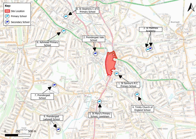
2.11 LSC hosts a wide range of food and non-food retail including supermarkets and facilities such as a post office and a pharmacy. There are several schools within a circa 2km walk. These are shown in Figure 2.4 and outlined below:
• 1. St Saviours R.C. Primary School
• 2. Prendergast Vale Secondary School
• 3. St Matthew Academy
• 4. Trinity C of E Primary school
• 5. St Mary’s Primary School
• 6. Ashmead Primary School
• 7. Prendergast Secondary School
• 8. St Stephens C of E Primary School
• 9. Prendergast Ladywell Secondary School
Proposed
Overview
2.12 An overview of all pedestrian, cyclist and servicing accesses and key routes are provided in Figure 2.5 below.
Figure 2.4: Local Schools

2.13 The vision for the Proposed Development is a space dominated by pedestrian movements, creating an active environment and a sense of place. It is envisioned that the Proposed Development will be characterised by active frontages and attractive landscaping creating a space where shoppers, residents, employees, and visitors can spend time outside.
2.14 The proposals will provide several north-south and east-west pedestrian routes through the Site as shown in Figure 2.6 below. The former will enable shoppers, residents, employees and visitors to travel from Lewisham station and Lewisham Gateway to the north, through the centre of the Proposed Development towards Lewisham High Street. The creation of new pedestrian desire lines through the Site will help to alleviate existing pedestrian pinch points on the High Street.
2.15 New east-west pedestrian routes will be created opening out the centre of the Proposed Development to the High Street and Molesworth Street to allow for connections to wider transport networks.
2.16 Furthermore, routes through the public realm, once again connecting Rennell Street, Molesworth Street, and Lewisham High Street, are accessible on Levels 01 and 02, which shall feature step-free access for future residents and visitors to the town centre.

Northern Routes
2.17 The pedestrian routes in the north of the Site are illustrated in Figure 2.7 below.
Figure 2.6: Key Pedestrian Routes
Figure 2 7:

2.18 The northern route provides an improved connection between Lewisham station, and Lewisham High Street via a new northern square which will form a key civic space within the redeveloped site. In addition to convenience, which will ensure people choose to walk, it is also a more welcoming environment where people feel safe, have places to stop and rest and accommodate all walks of life. The Proposed Development features a wide unrestrictive pedestrian zone, as shown in Figure 2.7, with planters, trees, tables, and benches. This ensures that the public realm within the Site is an area to visit, as well as a facilitator of movement. This route has been identified as a ‘primary pedestrian access’.
2.19 For the northern and southern areas there will be some limited vehicular access to permit servicing, refuse collection and blue badgeparking access. However, these spaces will be designed at a pedestrian scale with the focus on ensuring pedestrian movements are prioritised, a high-quality urban realm is provided, and vehicle movements are managed.
2.20 The crossing north of the Site, across Rennell Street, is in excellent condition, featuring a wide walkway, dropped kerbs and tactile paving. In order to further improve the mobility of pedestrians to and from the Site, as well as improving safety for active travel users, it is proposed that the green signal time for pedestrians is doubled at this crossing from 24 seconds to a total of 48 seconds. This would reduce the current waiting time of pedestrians from a maximum of 74 seconds to a maximum of 28 seconds.
2.21 Access to the Detailed Application areas (N1 & N2) are illustrated in Figure 2.8
Pedestrian and Cycle Routes into Northeast of the Site
Figure 2 8: N1 & N2 Core Access Points

2.22 The N1 proposals consist of four accesses of which three have step-free access with the remaining north western access leading to a stair core. The southernmost access on the western side of N1 leads into the lobby. The access on the eastern side of the western block is a back door for deliveries. Both of these accesses route to the cycle lift providing access to the cycle store located on first floor. From the cycle store, access can be achieved for all residents to their respective unit. The southern access to the eastern block of N1 directs pedestrians into the building core, via a corridor, which connects to the lift and staircase lobby, which provides access to the cycle store located on the first floor.
2.23 For N2 both accesses are step free with the northern access leading straight into the lobby which connects to a Parcel Safe Space and the cycle store.
East-west Routes
2.24 The proposed northern, central, and southern east-west pedestrian routes are illustrated in Figure 2.9 below.
Figure 2 9: Proposed Development East-West Pedestrian Through Routes

2.25 The central east-west route (shown in green in Figure 2.9) through the shopping centre connects Lewisham High Street, to the east, to Molesworth Street, to the west. This enables those using the bus stops on Molesworth Street or those parking at Molesworth Street car park to better access the retail units along Lewisham High Street and Lewisham Market, as well as better connecting future Site residents to the abundance of amenities along Lewisham High Street. The access improves experiences for those with physical impairments, by reducing travel time and increasing the directness of this route and enables the public realm to be more permeable for pedestrians.
2.26 The northern east-west route (shown in blue in Figure 2.9) is further enhanced by proposals to relocate the existing staggered toucan crossing and provide a new straight-across toucan crossing on Molesworth Street. This would be located along the desire line of the existing underpass link to Cornmill Gardens/Ravensbourne River. The proposals would result in the relocation of the existing signalised crossing further north and the relocation of bus stands on Molesworth Street. The proposals do not result in the loss of bus stands or blue badge spaces as part of the proposals, as shown within Appendix B. An indicative illustration of this is shown in Figure 2.10 and Appendix C

2.27 The presence of this proposed crossing allows pedestrians to still access Molesworth Street car park, whilst also providing more efficient routing to Cornmill Garden Playground, River Mill Park, Prendergast Vale School, and Hilly Fields, all of which are valuable nearby amenities for future Site users.
North-south Routes
2.28 In addition to the key routes mentioned above, the scheme will enhance permeability through the centre of the scheme by providing a throughfare for pedestrians from the north
Figure 2.10: Proposed Toucan Crossing – Molesworth Street
of the site at Rennell Street to the south of the site onto Molesworth Street and the south of Lewisham High Street. This route is shown overleaf in Figure 2.11
Figure 2.11: North-south routes

2.29 The north-south route connects to the sheltered central area of the Proposed Development, which will be fully pedestrianised with no vehicular access (except for emergency). This ensures that the core of the Site is an area for future site users to congregate, and a pleasurable and desirable public realm.
2.30 The north-south route provides an alternative to Molesworth Street for accessing Lewisham Station from the south of the shopping centre. Molesworth Street is an existing north-south route where improvements will also be made.
2.31 Enhancements are proposed to be made along the eastern side of Molesworth Street, in order to provide an attractive public realm that incentivises future Site users to travel by active travel modes. This includes a generous footpath of minimum 4m width (except for a short pinch point) for free-flowing, multi-directional pedestrian movements, as well as proposed buildings set back from the road, planters, and mature trees. Cross section of what this could look like are provided in Figures 2.12 and 2.13


Figure 2 12: Molesworth Street Cross Sections 1 & 3
Figure 2.13: Molesworth Street Cross Section 2
2.32 Molesworth Street will also benefit from active frontages as a result of the new residential homes, as part of the Proposed Development. In turn, this means the presence of residential lobbies, thus more people, increasing surveillance and enhancing a feeling of safety. There will also be extensive urban realm improvements on Molesworth Street to make the street more attractive through additional planting, widening footways to 4m and creating active frontages, a sketch of how this could look is provided in Figure 2.14

Southern Routes
2.33 The southern end of Lewisham Shopping Centre will have new through-routes created both east-west, as detailed above, opening up Molesworth Street to Lewisham high Street and north-to south connecting Molesworth Street and the centre of the shopping centre to the southern square. These routes are shown in Figure 2.13
Figure 2.14: Molesworth Street Indicative Sketch of Improvements
Figure 2 15: Southern Pedestrian Routes

2.34 These routes extend to a southern square adjacent to the Corporation of London building which will host live events such as comedy and music. This area will be a key trip attractor for pedestrians and as such the scheme has enhanced the permeability of this area.
Upper Levels
2.35 As shown in Figure 2.16, the upper levels will comprise key pedestrian areas for resting and play. On the first floor there will be an area known as ‘The Street’ which forms an upper concourse connecting the Northern Square and the eastern frontage of the Proposed Development onto Lewisham High Street. In the centre of the Proposed Development there will be an open-air park. These proposals are shown in Figure 2.14 This cohesive landscape knits the different public realm areas with existing areas outside of the Site. Frontages onto these areas are highly animated to create activation and surveillance throughout the day and evening. This in line with the Healthy Street approach, by creating places that feel welcoming and relaxed, cater for all walks of life and feel safe by providing abundant surveillance.
2.36 Upper levels will be accessed by a combination of stairs, lifts and escalators. The location of vertical access points is provided in Figure 2.16
Figure 2 16: Upper-Level Pedestrian Routes

Cycling
Existing
2.37 Figure 2.17 shows the existing cycling connectivity and infrastructure around the Site.
Figure 2 17: Existing Cycling Connectivity and Infrastructure

2.38 Cycling improvements have already been made to a section of the A21 between Lewisham and Catford. These were introduced in late 2020 to encourage a healthy and sustainable recovery from COVID-19. Along Molesworth Street, this includes an on-carriageway cycleway, enabling cyclists to travel northbound in a separate lane. Moreover, a shared footway/cycleway on the western side of Molesworth Street permits cyclists to travel southbound, segregated from the traffic.
2.39 Lewisham High Street / Rennell Street, Molesworth Street / Rennell Street, and Molesworth Street / Lewisham High Street / Engate Street junctions all feature advanced cycle stop lines.
2.40 National Cycle Route (NCR) 21 passes through Lewisham to the west of Ravensbourne River along Marsala Road and providing off-road cycling opportunities. The proposed relocated toucan crossing would improve the link to NCR 21 from the Site.
Proposed
2.41 The Proposed Development will utilise the good cycling infrastructure currently in place surrounding the Site. The proposed toucan crossing on Molesworth Street will help to reduce severance to NCR 21, and thus improve accessibility to key destinations. The Proposed Development will provide links through the Site, and between the Site and the existing cycle infrastructure.
2.42 As shown at Figure 2.4, cycling will not be permitted through the shopping centre. However, it is proposed that cyclists will be able to travel on the southern servicing route and the eastwest route in the southern area of the masterplan, which will facilitate a connection from Molesworth Street to Lewisham High Street for cyclists. These proposals will be determined at reserved matters stage and be subject to detailed design and a safety audits.
2.43 Cyclists are permitted in the N1 and N2 servicing areas for access into their blocks however through-cycling will be discouraged. Visitor cycle parking will be provided at appropriate locations.
Public Transport Accessibility Level (PTAL)
2.44 The Public Transport Accessibility Level (PTAL) is a measure of the relative accessibility to public transport in an area. It takes into consideration factors such as distance, type and frequency of services in this. PTAL is categorised in eight levels, 1a to 6b where 6b represents a high level of accessibility and 1a the lowest level of accessibility.
2.45 The Site has a PTAL of 6b, the highest level available. The WebCAT PTAL report is contained at Appendix D
Public Transport
2.46 The public transport nodes in proximity to the Site are excellent, as evidenced by the maximum PTAL score. The key public transport bus stops and stations are illustrated in Figure 2.18
Figure 2 18: Public Transport Plan

Bus – Existing
2.47 On the eastern side of the Site, Lewisham High Street provides seven bus stops. Similarly, on the western side, Molesworth Street provides two sets of bus stops. Each stop is no more than circa 50m walking distance from a pedestrian access to LSC. A summary of the frequency of services from all bus stops within the vicinity of the Site are presented in Table 2.1
2.48 Table 2.1 shows that the bus stops provide access to 28 bus routes, including 4 night-time services. As such, each stop is served by a bus every 2 minutes on average.
Bus – Proposed
2.49 There are two new east-west connections, between High Street and Molesworth Street, which will be 24/7 or open until the last bus. This will create an attractive route for pedestrians to access bus stops on either side of the Site.
2.50 The proposed toucan crossing across Molesworth Street, as well as the new southern servicing ramp will require bus stops/stands to be slightly moved, however this will have no impact on the access to, or frequency of, services.
Rail and DLR –
Existing
2.51 The nearest rail stations are Lewisham DLR and Lewisham Station, which are approximately 170m and 240m (3/4-minute) walk to the north of the Site, respectively. These stations provide DLR and Southeastern (National Rail) services. A summary of the frequency of Southeastern and DLR services are presented in Table 2.2
Table 2.2: Summary of Rail and DLR Service Frequencies
2.52 Table 2.2 indicates a DLR service departs approximately every 4 minutes, terminating at Bank. For Southeastern services, Lewisham Station provides up to 13 trains an hour into central London, 10 eastbound trains per hour and 5 southbound trains per hour.
Rail and DLR – Proposed
2.53 The Proposed Development will improve access to Lewisham Railway and DLR Stations through providing a north-south pedestrian link, enabling residents, employees, and visitors to travel between the south of the Site, through the Proposed Development to the station.
2.54 The Lewisham Gateway site, to the north, will provide a pedestrian route through their site, aligning with the key pedestrian desire line from the Proposed Development north-south pedestrian link.
2.55 Chapter 7 includes an assessment of the impact of the Proposed Development on the existing rail and DLR services.
Proposed Bakerloo Line Extension
2.56 TfL propose an extension of the Bakerloo line, to improve sustainable transport mobility in southeast London. The current proposals are to extend the line beyond Elephant & Castle to Lewisham station, via Burgess Park, Old Kent Road, and New Cross Gate. Both Burgess Park and Old Kent Road would require the construction of new stations. This would offer quicker journey times and better connections into Central London.
2.57 Furthermore, a second phase is being considered, which would extend beyond Lewisham, before splitting following New Beckenham, terminating at Hayes and Beckenham Junction. To achieve this, the existing National Rail line to Hayes would be converted to support London Underground services.
2.58 The first phase of the proposed Bakerloo line extension is shown in Figure 2.19 below.

Figure 2 19: Proposed Bakerloo Line Extension – Phase 1
2.59 Progress has slowed on the delivery of the Bakerloo line extension, in part due to funding reevaluations. The current estimations lie between £5-8 billion, with TfL requiring long-term funding from the Government. Following the election of a new Government, discussions have restarted, with a goal to construct through the 2030s, to be operational by 2040.
2.60 Additionally, recently re-elected London Major Sadiq Khan proposed a new ‘Bakerloop’ express bus service, as part of his campaigning policies. This bus service would mimic the proposed Bakerloo line extension route, providing more immediate relief to some of the existing severance issues sought to be tackled by the Bakerloo line extension.
2.61 The Proposed Development has been designed in order to not preclude the Bakerloo line extension proposals. Figure 2.20 indicates the area for safeguarded land. Although the safeguarded land appears to go over the application boundary, this is just the area of Molesworth Street that is included within the application for relocating an existing crossing and as such does not preclude the extension coming forward. The Proposed Development itself does not need to Bakerloo line extension to facilitate sustainable travel.

Figure 2.20: Bakerloo Line Safeguarded Area
Private Transport
Taxi Drop-off
2.62 For those who require transport by car, there are three points in the vicinity of the Site. The location of the local taxi ranks and their approximate distance from the LSC are as follows:
• Lewis Grove (50m / 1-minute walk east)
• Albion Way (50m / 1-minute walk east)
• Lewisham Station (450m / 6-minute walk north)
2.63 The location of the local taxi services is shown in Figure 2.21.

2.64 Lewis Grove facilitates a waiting area for two taxis, six taxis can wait on Albion Way and there is designated space for several taxis to wait at Lewisham Station.
2.65 Taxi drop-offs and pick-ups will continue to operate in line with the existing situation at LSC with the exception of a new taxi/ blue badge drop off-area provided on the southern servicing route.
Local Highway Network
2.66 Figure 2.22 illustrates the key roads in proximity to the Site as well as access for public and delivery and servicing vehicles.
Figure 2.21: Existing Taxi Ranks Around LSC
Figure 2 22: Local Highway Network Plan

2.67 Molesworth Street (A21) is a dual carriageway which runs along the western boundary of the Site. Lewisham High Street is a two-way single carriageway forming the eastern boundary of the Site until its junction with Albion Way. At this junction, Lewisham High street turns into a service access only, bordering the Site to the east with all remaining vehicles travelling east down Albion Way with access to the north (via Lewis Grove) only permitted for HGVs and vehicles over 7.5t only.
2.68 Molesworth Street (A21) and Lewisham High Street connect to the A20 to the north of the Site. The A20 forms a connection between the A2 in the north-west and the M25 in the south-east. Molesworth Street (A21) and the A20 are part of the TfL ‘red route’ network, which form part of the major road network within London.
2.69 There are two main vehicular access points to the shopping centre from Molesworth Street. To the north, a ramp provides access to MSCP. An adjacent ramp provides access to the servicing deck for the shopping centre, which is located at first floor. Similarly, separate egress ramps are located at the south-west corner of the shopping centre for vehicles exiting the MSCP and servicing deck.
2.70 Salisbury Yard, which is located to the north of the shopping centre, is accessed from the A20, is also used by vehicles, although this is a no through road, and does not provide direct access to the shopping centre.
2.71 The Market Trader’s yard is located to the east of the shopping centre and serves only the traders of the market stalls located on Lewisham High Street.
Parking Restrictions
2.72 Lewisham Shopping Centre is located within an existing Controlled Parking Zone (CPZ) ‘Zone B’ as shown in Figure 2.23. This operates Monday to Saturday 09:00-18:30.
Figure 2.23: Controlled Parking Zone

3.0 Interim Travel Patterns
Residents
3.1 For the purposes of this FTP, it is assumed that the travel patterns of residents will be in line with the analysis that has been used to assess the impact of the Proposed Development upon the transport network. This has produced separate mode shares for Phase 1a and the Outline Application, respectively.
3.2 The interim modal split for Phase 1a of the Proposed Development is shown in Table 3.1. This comprises 445 co-living and 119 built-to-rent (BTR) homes, and a combination of both internal and external trips, with all internal trips assumed to be on foot.
Table 3.1: Travel Pattern Analysis – Phase 1a Residential Mode Share
*Errors in sums due to rounding
3.3 Table 3.1 shows that no residents are anticipated to travel to and from the Site via private car. This is due to the Proposed Development being car-free. It is anticipated that 20% of trips will be undertaken using public transport modes, whilst 79% of trips are undertaken using active travel modes.
3.4 The interim modal split for the Outline Application of the Proposed Development is shown in Table 3.2. This comprises 1,524 residential homes and is once again a combination of both internal and external trips, with all internal trips assumed to be on foot.
*Discrepancies in sums due to rounding
3.5 Table 3 2 shows that no residents are anticipated to travel to and from the Site via private car. This is due to the Proposed Development being car-free. It is anticipated that 19% of trips will be undertaken using public transport modes, whilst 80% of trips are undertaken using active travel modes.
Employees
3.6 The mode share for employees has been devised using ‘Journey to Work’ data, from the 2011 Census, for the Lewisham 012 Middle Super Output Area (MSOA). The interim employee mode share splits are shown in Table 3.3
3.7 The modal split has been adjusted to account for the car-free nature of the Proposed Development. As such, the ‘Driving a car or van’ and ‘Passenger in a car or van’ split has been distributed evenly amongst all other modes.
Table 3 3: Modal Share based on 2011 Census Data – Employee Mode Share
* Discrepancies in sums due to rounding
3.8 Table 3 3 shows that 77% of employee journeys are anticipated to be undertaken using public transport, whilst 21% are anticipated to be undertaken using active travel modes.
Student Accommodation
3.9 The student accommodation mode split has been calculated using carefully selected TRICS database surveys, and subsequently adjusted to account for the car-free nature of the Proposed Development. The modal split is shown in Table 3 4
Table 3.4: Modal Share based on TRICS Database – Student Mode Share
*Errors in sums due to rounding
3.10 Table 3.4 shows that 43% of student accommodation journeys are anticipated to be undertaken using public transport, whilst 57% are anticipated to be undertaken using active travel modes.
3.11 The Detailed Application (within Phase 1a) features residential homes and commercial units only, whilst the Outline Application comprises residential and student accommodation homes, in addition to commercial units.
3.12 Following six months of meaningful occupation of the Site, resident, employee and student questionnaire surveys will be undertaken to establish the baseline modal split for the purposes of monitoring this Travel Plan. This will be undertaken for each block of the Proposed Development as individual blocks are occupied
3.13 The content of the travel surveys will be discussed with LBL (hereby referred to as ‘the Council’) Travel Plan officers prior to the survey being undertaken. The undertaking of the baseline survey represents the start of the Travel Plan for monitoring purposes and is described as Year 0.
Analysis of Survey
3.14 The results of the travel survey will provide information on the established travel choices of residents, student and employees, thus providing a basis for ratifying and adjusting the targets as set out in this FTP.
3.15 The survey will aim to:
• Identify which modes of transport could be promoted in light of the survey findings; and
• Establish the popular alternative modes of travel to the Site, i.e. what do people want to use but currently do not/cannot.
4.0 Objectives and Targets
4.1 This chapter sets out the overarching objectives for all future Travel Plans (TP), as well as targets for the short and medium term. It includes indicators through which progress towards meeting the targets will be measured. Further information on monitoring and review of TP can be found in Section 7
• Objectives are the high-level aims of the TP. They help to give the TP direction and provide a clear focus.
• Targets are the measurable goals by which progress will be assessed. The TP sets out targets which Proposed Development will seek to reach within the period covered by this TP. In addition, interim targets have been set.
Objectives
4.2 The transport principles for the Proposed Development reflect sustainable objectives which can be summarised under the following headings:
• Ensure that future Site users are using sustainable transport modes, rather than single-occupancy vehicles;
• Encourage residents, employees, and students to increase their use of active travel modes, rather than public transport; and
• Increase the awareness of the environmental and social benefits of using active travel
4.3 The above TP objectives are consistent with the objectives set out within policy guidance which, among other things, generally aim to increase accessibility to services, reduce the impact and effect of congestion and widen travel choice.
4.4 The more detailed objectives of the TP are to:
• Increase resident, employee and student awareness of the advantages and availability of sustainable modes, but particularly active modes;
• Actively promote sustainable transport options for travel to and from the Proposed Development, to enable informed decisions about how to travel;
• Increase the use of active and sustainable travel modes, and to encourage residents, employees and students to build active travel into their everyday routines to support and contribute to wider health benefits;
• Enhance as far as is practical, the accessibility of the Proposed Development by active modes; and
• Raise awareness of the impacts of travel choices on health, the local environment etc.
4.5 These objectives will be achieved by introducing a package of physical and management measures that will facilitate resident, employee and student travel by sustainable modes.
Targets
4.6 TP targets are measurable goals by which progress can be assessed. These targets should be reviewed through a programme of monitoring (outlined in Section 6) to ensure they remain SMART (Specific, Measurable, Achievable, Realistic and Timed).
4.7 Targets come in two forms - Action and Aims. Action Targets are non-quantifiable actions that need to be achieved by a certain time. Aim Targets are quantifiable, and in the case of this TP, generally relate to the degree of modal shift the plan is seeking to achieve.
Action Targets
4.8 The Action Targets for this Site are:
• To appoint a Travel Plan Coordinator (TPC) prior to initial occupation of the Site;
• To launch the TPs upon occupation of different phases of the Site;
• To provide travel information to all residents, employees, students and visitors of the Site; and
• To coordinate baseline travel surveys.
Aim Targets
4.9 The targets are set to measure progress towards the main objectives over five years. Following the launch of the TP and the undertaking of each baseline travel survey, these targets are to be achieved within five years of meaningful occupation, with this time period varying between phases of the Proposed Development
4.10 The Site will be developed to enable and encourage sustainable travel by its residents, employees and students, predominately through its car-free nature. Therefore, the Aim targets comprise an increase in active travel modes, rather than a decrease in singleoccupancy vehicle use.
4.11 A baseline travel survey for residential, employee and student accommodation uses will be undertaken within six months of meaningful occupation, for each block of the Proposed Development. These survey results will form the results of the Year 0 survey.
4.12 This FTP recognises that it is not possible to set out accurate targets far in the future, even when based on actual modal share data (i.e. when the baseline survey has been undertaken). Given this, it should be acknowledged that the targets will change over time as results from on-going monitoring become available. This will be discussed with relevant officers at the Council
4.13 The targets below are individual to Phase 1a of the development, with a baseline survey to be undertaken within six months of any new phase of the development. As such, these surveys are likely to progress for longer than five years, if other phases of the development are to come forward.
4.14 Table 4.1 sets out the Aim targets for the residential aspect of Phase 1a of the Proposed Development This comprises 445 co-living and 119 BTR homes.
4.15
Table 4 1: Phase 1a – Travel Plan Aim Targets for Residents
4.16
Table 4.2 sets out the Aim targets for the residential aspect of the Outline Application, for the Proposed Development. This comprises 1,524 homes.
Table 4.2: Outline Application – Travel Plan Aim Targets for Residents
4.17
Table 4.3 sets out the Aim targets for the commercial aspect of the Proposed Development. This modal split is applicable to both Phase 1a and the Outline Application.
Table 4.3: Phase 1a & Outline Application – Travel Plan Aim Targets for Employees
Table 4.4 sets out the Aim targets for the student accommodation aspect of the Proposed Development As there are no student accommodation homes within the Phase 1a proposals, these targets are only applicable to the Outline Application.
Table 4 4: Travel Plan Aim Targets for Students
4.18 Targets are set over a 5-year period from first occupation. The targets within the TP will be aimed to be achieved by the 5th anniversary of the baseline travel survey. There will be a review of the progress towards targets on the 1st and 3rd anniversary of the initial baseline travel surveys.
4.19 These travel surveys will be iTRACE compliant, and a Travel Plan Monitoring Report will subsequently be produced within 3 months of the travel surveys being undertaken.
4.20 The percentages set out for Years 1 and 3 are indicators of progress, they are not targets. The targets of the Travel Plan are those set out for Year 5. These targets will be achieved by the strategy and measures set out in the following sections.
4.21 A baseline survey is to be undertaken within six months of any new phase of the Proposed Development. As such, these surveys are likely to progress for longer than five years, if other phases of the Proposed Development are to come forward.
5.0 Travel Plan Strategy
Management
Travel Plan Co-ordinator
5.1 A TPC will be appointed at least 2 months prior to occupation of the Site to implement and administer the Travel Plan on a part-time basis. The TPC will have overall responsibility for ensuring that the delivery of the proposed measures and initiatives are successfully delivered on time and to budget for that aspect of the Proposed Development.
5.2 The TPC will oversee all uses within the Detailed Application, including residential and commercial uses. If further phases of the Proposed Development are to come forward, then the initial TPC may see their duties expand across the new phase, or if this is deemed too much work, another TPC may be appointed.
5.3 The TPC will work with key stakeholders including the Council and TfL.
5.4 The TPC will have to understand and implement local transport initiatives and promote the Travel Plan at a local area level.
5.5 The duties of the TPC will therefore include:
• To provide guidance to, and be the main point of contact for residents, employees and students within the Site requiring travel information;
• To offer a personalised Travel Planning service for all future Site users, on request;
• To communicate information regarding relevant national and local initiatives related to the promotion of sustainable travel;
• Demonstrate how the budget will be used and justify the need for the level of budget (if the TPC requires more money than originally allocated);
• Undertake the travel surveys over the first five-year period of each phase, and supply evidence of this to the Council;
• Take responsibility for data collection and review of the Travel Plan;
• Design and implement effective marketing and awareness-raising campaigns to promote the TP;
• Liaise with external organisations, e.g. local authorities; and
• Co-ordinate the monitoring programme for the TP, including target setting (in agreement with the Council) and make necessary changes if the targets are not being met.
5.6 The TPC could also hold ‘surgeries’ within the local community where they will be available for consultation, training or meetings at agreed times.
Funding
5.7 The TP, its accompanying measures and initiatives, and the TPC role will be funded by the developer throughout each five-year period, for each potential phase of the Proposed
Development. The developer will ensure that the TPC has sufficient funding to effectively implement the Plan.
Time Allocation
5.8 The TPC will undertake the management of the TP, fulfilling the objectives set out at the start of Section 4
5.9 It is expected that upon implementation of the TP and during monitoring and reporting times, the TPC will be busiest and may need to spend more time on the TP. It is also expected that as the TP progresses for each phase, the level of input required by the TPC for that respective phase will reduce.
5.10 The TPC will mainly be based off-Site but would commit to a number of days per year onSite, typically surrounding the annual surveys.
Reporting
5.11 The TPC will prepare a full report on a biennial basis, on the progress of the TP. The reports will include the following:
• Progress on the implementation of measures and initiatives to promote sustainable transport use;
• Latest survey results (surveys undertaken biennially following baseline survey – Year 1, 3, 5); and
• Any revisions to targets and measures.
• The reports will be provided to the Council Travel Plan Officers.
Marketing Strategy
5.12 An essential element of the TP strategy, and one which largely determines its success, is the promotion of the TP. In order to promote and increase awareness of the TP, the following measures will be adopted:
• Distribution of Travel Information Packs to all future Site users. These will be provided to all residents and students upon occupation of their home, in addition to employees of the commercial units upon occupation. The Travel Information Packs will include website details, maps, public transport routes and frequencies, benefits of active travel, and details of local amenities;
• Display of key TP information on the TP noticeboards, community website and leaflets;
• Mail drops can be used to disseminate new information or promote events;
• Arrange Q&A sessions and offer a personalised travel planning service to all future Site users;
• Promote national travel initiatives and organise site-wide events such as organised cycle rides or Walk to Work weeks;
• The Developer will arrange for the display and distribution of sustainable travel information at the marketing suite for the Proposed Development and on the marketing website; and
• TPC will attend relevant resident, employee and student meetings / Local Parish Council Meetings to promote the TP
5.13 The types of information to be provided include:
• Public transport timetables, infrastructure locations and telephone enquiry lines;
• Local taxi numbers;
• Walking and cycling routes;
• Community guides about facilities and services within and near to the Proposed Development; and
• Travel planning websites and contact details
5.14 As aforementioned, the Travel Information Packs will be distributed to all households (resident and student) upon initial occupation and distributed to all employees of the commercial units upon occupation. The Travel Information Packs will also include locations of accessible public transport for those with mobility impairments. Information regarding the website will be included within the Travel Information Pack.
5.15 A Travel Plan website will also be created, which will act as a focal point for all travel information relating to the Site. The website will provide up-to-date links to walking, cycling and public transport services and advertise sustainable transport events. If other phases are to come forward, information on new active travel routes and sustainable transport infrastructure will be provided on the website and within updated Travel Information Packs.
6.0 Measures and Initiatives
Introduction
6.1 This section of the FTP outlines the specific physical and management measures to be undertaken as part of the TP, in addition to a number of possible initiatives that could be implemented, should they be deemed appropriate.
6.2 The measures outlined below are not exhaustive and the TPC will be free to investigate other potential initiatives, in an attempt to reach and potentially exceed the targets set out in Section 4. An Action Plan is also included within Section 8 which sets out the measures.
Information
6.3 All future Site users, upon occupation, will be provided with a Travel Information Pack.
6.4 The Travel Information Pack will include the following information:
• Name and contact details of the relevant TPC and their availability to speak with Site users;
• An introduction to the TP, its purpose etc., and a summary document;
• Bus and rail route maps and timetables and any other public transport information;
• Walking and cycling route maps, with particular emphasis on access to local facilities, around the town centre and nearby rail stations (namely Lewisham DLR and railway stations);
• Details regarding cycle training and associated discounts on cycles and cycling equipment at local cycle stores;
• Any details on student discounts on cycling equipment or public transport tickets/passes;
• Any information regarding school travel including school buses/walking buses etc; and
• An introduction to the Travel Plan website.
Walking
6.5 As set out in Section 2, specifically Figure 2.5, an abundance of pedestrian routes have been provided throughout the Site, in all directions, in order to promote travel on foot. This has been a focal point of the Site design, to create improved pedestrian mobility through Lewisham Town Centre, and subsequently reducing severance in the area.
6.6 The network of high-quality signposted pedestrian routes will offer direct, safe and convenient access around and through the Site by foot. The entire Proposed Development comprises six pedestrian or ped/cycle only accesses, three of which egress onto Molesworth Street to the west, one which enables access to the southern extent of the Site, one onto Lewisham High Street to the east, and a final access onto Rennell Street to the north. Furthermore, two additional accesses, one on Molesworth Street and another on Lewisham High Street, permit access for both active travel users and servicing vehicles.
6.7 Phase 1a is located in close proximity to a large area of attractive proposed public realm, to the north of the Site, which links three pedestrian access points enabling travel northbound, eastbound and westbound of the Site.
6.8 The design of local roads has also been structured to create active travel improvements in the area, as evidenced through the Healthy Street Check for Designers, undertaken on five segments surrounding the Site.
6.9 Crucially, the car-free nature of the scheme enforces active travel, primarily in the form of pedestrian movements, even if these are part of a multi-modal trip, i.e. walking to the Lewisham DLR station.
6.10 The TPC will report the results of the travel survey to the relevant Council Officer and will liaise with that Officer to establish the potential for improvements to existing off-Site facilities.
6.11 The TPC will also seek to ensure that pedestrian routes are appropriately maintained.
6.12 The TPC will promote the Health benefits of walking and explore the possibility of using such schemes as ‘10,000 steps a day’ campaign, or a ‘Walk to Work’ week.
Cycling
6.13 The Detailed Application will provide 536 long-stay cycle parking spaces, and 50 short-stay cycle parking spaces. A detailed breakdown has been provided in Table 6.1 below.
6.14 N1 and N2 will each have a dedicated lift from the ground floor to the cycle store located at the first floor. A secondary lift suitable for cycles from the main core will also be available for use in the case of a breakdown.
6.15 The Outline Application will provide cycle parking in line with the London Plan, for residents, employees, students and visitors. The cycle parking will be located in various locations to be determined within the illustrative masterplan as reserve matters applications come forward.
6.16 Both the Detailed and Outline Applications will ensure that 5% of all cycle parking can cater for larger cycles, as per LCDS standards. Furthermore, the cycle parking will comprise 20% Sheffield stands and 75% two-tier stands. All cycle parking will be located on-Site.
6.17 An abundance of cycle infrastructure already exists surrounding the Site, as shown in Section 2, specifically Figure 2.17. Furthermore, the proposed development includes
Table 6.1: Phase 1a – Cycle Parking Provision
moving the toucan crossing on Molesworth Street further north, to reduce severance to NCR 21, and create a key desire line for cyclists.
6.18 Regarding Phase 1a, cyclists can use the northeast servicing access and egress. However through-cycling will be discouraged. This is with the aim to promote cycling for Phase 1a residents and employees, and provide a safer, quiet cycle access to the detailed application area.
6.19 The TPC will also seek to ensure that cycle routes are appropriately maintained. This will be achieved through a regular dialogue with the Council
6.20 Future Site users will be provided with information and advice concerning safe cycle routes to the Site and the TPC will promote the health and economic benefits of cycling through the use of campaigns, such as National Bike Week.
6.21 Furthermore, the TPC will explore with local bicycle retailers the possibility of providing discounts on cycling equipment to residents and students of the Site. The take up of this discount, if agreed, will be monitored.
6.22 Management of commercial units will be urged to provide ‘Cycle to Work’ schemes for their employees. Once again, the take up of this, if agreed, will be monitored.
Promotion of Walking and Cycling
6.23 Walking and cycling routes will be advertised in prominent locations such as on the website and in the Travel Information Packs. In addition, events such as National Bike Week will also be promoted as part of the TP and the TPC should investigate these events further.
6.24 Cycle training will be offered and funded by the TPC. The TPC will also liaise with local retailers to provide discount vouchers for bicycles and associated equipment.
6.25 Moreover, the Council, via ‘Peddle My Wheels’, offer a ‘Try Before you Bike’ scheme, which is designed to encourage Lewisham residents to cycle. The scheme enables residents to pay monthly for a bike (including electric, folding and adaptive varieties), in order to take away the discouragement of an outright, larger fee to purchase a bicycle. The scheme provides many benefits, including:
• Free delivery to your door, with all necessary accessories (helmet, lights, lock etc);
• A bespoke training session of up to two hours, if required;
• No deposit;
• Affordable options; and
• Free bicycle collection if you wish to return the bicycle
6.26 Additionally, the Council offer free cycle lessons for those of varying ages (7-13, 13-17, over 18), as well as free lessons of varying difficulty (basic skills, urban skills, advanced skills).
6.27 Lewisham Cyclists, a local branch of the London Cycling Campaign (a non-profit organisation) encourage cycling within the Borough through various schemes, including:
• Bike repair workshops;
• Cycle buddy scheme;
• Advice on safe local routes; and
• Cycling equipment borrowing for families.
Public Transport
6.28 Up-to-date details of bus and train services, including route information and service frequencies, will be provided within resident, employee and student Travel Information Packs and will be displayed on the website. National Rail and National Journey Planner websites and enquiry phone numbers will be advertised through all relevant means.
6.29 A number of local bus services are accessible from the Site, providing access to 28 bus routes. Each stop is served by a bus every 2-minutes, on average. These bus routes provide access to key railway stations nearby, routes further into Central London, as well as routes further south out of London.
6.30 Much of Lewisham High Street, to the east of the Site, prohibits southbound travel for singleoccupancy vehicles, therefore buses have priority amongst much of this route.
6.31 The TPC will liaise with the relevant service operators to discuss the possibility of providing bus travel incentives. This could be especially valuable to students on-Site.
6.32 Furthermore, Lewisham DLR station and Lewisham station are located approximately 250m and 300m north of the northern site access, respectively. The DLR station approximately provides a service every four minutes, whilst Lewisham station provides up to 28 services an hour, approximately half of which are into Central London.
6.33 The proposed north-south pedestrian link through the Site will greater connect those from the southern extent of the Site to the Lewisham DLR and rail stations.
Reducing Travel/ Private Car Travel
Home Deliveries
6.34 To reduce the need to travel, the TPC will promote and raise awareness of the potential time, cost and environmental savings of home deliveries, including supermarket deliveries. All of the big four supermarkets, Sainsbury’s, Asda, Tesco and Morrisons, offer home delivery services, as do Waitrose and Ocado. The majority of online retailers also now offer home delivery services.
6.35 It is important to note that due to the location of the Site, the majority of future Site users should be able to walk/cycle to the supermarket for their groceries. However, the convenience of home deliveries cannot be understated, with the Site location also meaning that a wider variety of home deliveries are available.
High-speed internet
6.36 To reduce the need to travel, high-speed internet connection will be provided across the Site and therefore increase the attractiveness of working/studying from home.
Personalised Travel Planning
6.37 The TPC will promote a personalised travel planning service available to all future Site users and will promote this as each potential phase of the Proposed Development is built out. The TPC will ensure that residents, employees and students are reminded of the availability of the service through means such as the website and when the monitoring surveys are undertaken.
Parking Management
6.38 A total of 50 Blue Badge car parking spaces will be provided across the entire Proposed Development, with four Blue Badge spaces provided for Phase 1a only. One space will be provided for N1, whilst three spaces will be provided for N2.
6.39 All of the Blue Badge bays across the Site will be fitted with EV charging capabilities.
6.40 The use of Blue Badge spaces will be monitored by the TPC, and through the biennial travel surveys. If it is discovered that there are insufficient Blue Badge bays, then the developer will explore areas whereby further spaces can be provided.
6.41 The Site proposes the removal of the MSCP, which comprises 836 car parking spaces. Not only will this greatly remove vehicles from the local highway network, but it will incentivise visitors to LSC to use sustainable transport modes or utilise a ‘Park and Stride’ mode. This involves visitors parking at other car parks within Lewisham, such as Clarendon Rise Car Park, and subsequently walking to Site. Once again, this reduces single-occupancy vehicles in proximity to the Site, whilst promoting active travel.
7.0 Monitoring and Review
7.1 The TP is part of a continuous process for improvement, requiring monitoring, review and revision to ensure they remain relevant. This chapter sets out the proposals for monitoring and review of the TP
7.2 The monitoring programme will begin with the baseline travel surveys, to be undertaken within six months of meaningful occupation of individual blocks
7.3 Further surveys will be carried out biennially (Year 1, 3 and 5), to monitor progress towards the targets provided in Section 4, for a period of up to 5 years, following the baseline travel survey. The surveys would be carried out for a further 5 years, post full occupation, if targets have not been met. This process is to be carried out separately for each potential phase that comes forward.
7.4 Additional monitoring of comments received from future Site users are also useful to judge whether the implementation or proportion of certain measures needs to be modified.
Reporting
7.5 A biennial Travel Plan Review Report will be undertaken following the baseline surveys, within six months of meaningful occupation, in addition to Years 1, 3 and 5, by the TPC, to assess the progress of the Plan Additional measures will be introduced should it be identified that targets are not being met after Years 3 and 5. These measures could include:
• Increased promotion of bus services;
• More cycle parking / incentive schemes if the demand is required; and
• Increased presence of the TPC to promote the TP
7.6 The reviews will outline the results of the survey, measures that have been implemented and any changes to targets and measures as a result of the survey data. The report will also incorporate the results of monitoring throughout the preceding period.
7.7 The report will be issued to the Council within 30 days of the survey being undertaken. The TPC will be available to provide additional information to the council if required to do so.
8.0 Action Plan
8.1 The Action Plan outlined below in Table 8.1 sets out the measures included within the TP that are directed at influencing residential, employee and student travel. The Action Plan will be revised following each Travel Plan Monitoring Report
Table 8.1: Action Plan
Appointment of Travel Plan Coordinator
Undertake
Baseline (Year 0) Survey
Travel Plan Monitoring Surveys
The TPC will be a parttime role – to be implemented within 2 months prior to Site occupation
months prior to occupation of Site
Undertaken within 6 months of meaningful occupation of individual blocks
The subsequent survey will be undertaken 12 months after the baseline survey, and then biennially up to the period of 5 years
and student accommodations will receive a travel pack outlining the sustainable options for travelling to the Site and the existence and purpose of the Travel Plan Upon initial occupation of each home and commercial unit
The TPC will keep a record of those who have utilised the service as well as the nature of the service (group, on-to-one)
Bicycle and equipment discount
Provide cycle route maps and other information relating to cycle facilities
TPC to liaise with local retailers to provide discounts, and ensure that future Site users are aware of existing bike rental schemes in Lewisham
Provided as part of Travel Information Packs
Encourage cycling through awareness events such as National Bike Week and social bike rides Events to be promoted by website
Future Site users to be provided with information related to safe walking routes
Monitoring of local footway conditions
Bus/Rail Travel Incentives
As part of Travel Information Packs and on website
The TPC will monitor the condition of local and internal footways, to ensure they are wellmaintained
PublicTransport
TPC will liaise with service operators to potentially provide vouchers for discounted/ free travel passes, especially for students
Website with timetable, route and further information As part of Travel Information Packs and on website
Taxi Services
Ensure that taxi contact details are available for Site users
with
provided

Appendix A Proposed Development Masterplan
Framework Travel Plan
Lewisham Shopping Centre
Landsec Lewisham Limited
SLR Project No.: 425.000806.00001
18 October 2024

Appendix B Molesworth Street
Framework Travel Plan
Lewisham Shopping Centre
Landsec Lewisham Limited
SLR Project No.: 425.000806.00001
18 October 2024
36.5mDISABLED PARKING
17m(X4)ZIGZAG
4.5m(X1)ZIGZAG
139mBUSSTAND (10BUSES)
Key
MOTORCYCLEPARKING
13.2mDISABLEDPARKING
4.5m(X1)ZIGZAG
4.5m(X1)ZIGZAG
6.6mDISABLEDPARKING
EMERGENCYACCESS
19.8mDISABLEDPARKING
139mBUSSTAND (10BUSES)
BusStand/StopSpace:(8mGained) Existing-182m Proposed-190m Busstop
Disabledparking Zigzaglinemarking Pedestriancrossing Busstand Availablespaceforrelocatedbus stop/stand
17m(X4)ZIGZAG
17m(X4)ZIGZAG
43mBUSSTOP (3BUSES)
15mBUSSTOP(1BUS)
13.5m(X3)ZIGZAG
4.5m(X1)ZIGZAG
36mBUSSTOP (2BUSES)
Somedisabledparking retainedinthislocation.


Exisitngguardrailingtobe removedtotipandADS signtoberelocatedtonorth.
Existingtrees, approximatelocation.
ExistingpublicWC cubicletoberelocated.
Cyclelanetoterminate allowingshareduseof Toucancrossingfacility.
Proposedbuildoutto reducecrossingwidth.
Relocateddisabled parkingtoretainsame provisionasexisting.
ExistingToucancrossingto beclosedoffandlandscaping tobeprovidedwithincentral reservetomatchexisting.
Appendix D WebCAT PTAL Report
Framework Travel Plan
Lewisham Shopping Centre
Landsec Lewisham Limited
SLR Project No.: 425.000806.00001
18 October 2024


MolesworthStreetLondonSE137LWUK Easting:538177,Northing:175544
GridCell:56259
Reportgenerated:06/12/2021
CalculationParameters

Rail
Rail
