PORTFOLIO
The Curated Urban Design Works of CAO
TUAN
from 2020 to 2025
Admitted to Master of Architecture in Urban Design, Graduate School of Design, Harvard University

The Curated Urban Design Works of CAO
from 2020 to 2025
Admitted to Master of Architecture in Urban Design, Graduate School of Design, Harvard University
University of Architecture of Ho Chi Minh City, Institute of International Education, Department of Urban Design Third Year, First Semester, June to July 2020
Studio on Housing Design (School Course Name: Architecture and Building Shape)
Location Binh Dong Wharf, District 8, Ho Chi Minh City, Vietnam Area Approx. 2 hectares (or 4.9 acres)
Supervisor(s) M.Arch. NGUYEN Duc Long, M.Arch. LE Thi Bich Ngoc Individual Work
Integrating Community and Commerce
Binh Dong Wharf, District 8, HCMC, Vietnam Page 3 - 5
Saigon Port, Disctrict 4, HCMC, Vietnam Page 6 - 7
The phenomenon of an uncontrolled increase in the marginalized population in the Binh Dong wharf area creates many problems related to settling dwelling and community spaces for existing and new population groups. They have tried to isolate themselves from each other due to their differences in position in society and lifestyle. The initial population group in the area consists of poor households without legal ownership of land, living clustered in slums along the Doi and Ngang canals, separate from other population groups. In the future, if urbanization continues to intensify, it is likely that this group of people be forced to abandon the land that has been the foundation of their long-term livelihood. Is there any solution for these existing populations to accept living with their differences and concede to each other so no one has to give up where they belong?
The plan proposes a new strategy that creates a better living space by integrating community spaces with flexible trading spaces in the form of public markets while still respecting residents' privacy and personal space. This way, we can both maintain the means to make a living for the people while creating dynamic commercial spaces and strengthening community relationships.
Cau Muoi Neighborhood, District 1, HCMC, Vietnam Page 8 - 10
Hoa Hung Locomotive Factory, District 3, HCMC, Vietnam Page 11 - 13
Long Thanh Airport, Long Thanh District, Dong Nai, Vietnam Page 14 - 16


To address the pressing housing needs while still promoting community cohesion, the plan proposes creating three new prototypical housing units that can be stacked vertically to form complete buildings. This innovative design allows for efficient use of limited urban space while fostering a sense of community among residents.
The housing units will be designed as modular structures, each equipped with essential amenities and flexible living spaces. These units can be easily adapted to accommodate different family sizes and needs. Integrating flexible trading spaces, such as public markets, within the housing complex ensures that residents have easy access to economic opportunities. These spaces will be designed to respect the privacy of the residents while providing a vibrant commercial environment.


University of Architecture of Ho Chi Minh City, Institute of International Education, Department of Urban Design Third Year, Second Semester, September to October 2021
Studio on Architectural and Urban Preservation (School Course Name: Innovation and Regeneration) Third Place for the National Competition “Urban Planning for Ho Chi Minh City in 2040”
Location Saigon Port, District 4, Ho Chi Minh City, Vietnam Area Approx. 40 hectares (or 98 acres)
Supervisor(s) Prof. HO Viet Vinh
Collaborator(s) TRUONG Dinh Khoi, HUYNH Dai Nghia
Individual Role Researching and Mapping, Master Planning, Lead Designer, Prototyping, Final Production
A Lifeline of Heritage and Progress
The Saigon River plays an important role in shaping the identity of Ho Chi Minh City, shaping distinctive landscapes that live in people’s memories. The river serves as a conduit for diverse cultural influences from various communities, effectively knitting together the rich tapestry of heritage values that have culminated in the vibrant city we know today. Functionally, the Saigon River sprawls across a significant portion of the city’s terrain, serving as the foundation for human-environment connectivity. Therefore, the river-centric urban development continues to honor the city’s historical legacy, while forging a path toward a promising future: A legacy that Ho Chi Minh City alone can proudly claim. Creating a cultural and historical flow on the river has nurtured a nuanced community heritage, establishing a continuity that transcends time and space. The Saigon River, with its dynamic and diverse influences, has been instrumental in creating a unified yet multifaceted identity for the city. It is a central focal point for reflection, recollection, and catalyzing progress, serving as a living testament to the city’s evolution.
To foster engagement between individuals and their environment,
both through tangible urban elements and intangible humancentered aspects, it is essential to benefit from the river's presence to become a focus for future urban development. This includes integrating public spaces, parks, and cultural hubs that encourage interaction and community building, thereby enhancing the quality of life for residents.
The old Saigon Port, with its many underutilized warehouses and workshops, presents a unique opportunity for creative approach to redevelopment. The goal of the design is to create a detailed plan to redistribute land use in this area to avoid waste. The study area is a prime location for waterway and pedestrian access in recreation but this has not been fully realized to the benefit of the greater public. By reimagining this space, we can unlock this potential, transforming the place into a vibrant hub that honors the past while embracing future potential.
Through thoughtful urban planning and a deep respect for the river’s historical significance, Ho Chi Minh City can continue to build upon its rich heritage, creating a sustainable and thriving urban environment for generations to come.


Blending Heritage and Modern Development
For the Nha Rong port area, the proposal is to renovate warehouse facilities, transforming them into vibrant service hubs that revitalize the historic port. By preserving the architectural integrity of these warehouses while repurposing them for modern use, the plan aims to honor the area's rich past while providing functional spaces for the community. Through these strategic developments, the goal to recreate the vibrant public activities scene that Nha Rong was respected for.


University of Architecture of Ho Chi Minh City, Institute of International Education, Department of Urban Design Fourth Year, First Semester, November 2021 to February 2022
Studio on Building and Landscape Design (School Course Name: Landscape Architecture) Honorable Mention for ISCM Competition 2 - Smart City Concept
Location Cau Muoi Neighborhood, District 1, HCMC, Vietnam Area Approx. 18 hectares (or 44.5 acres)
Supervisor(s) D.Arch. TRAN Minh Duc (University of Hawaii at Manoa) Individual Work

The residential neighborhoods of Ho Chi Minh City, are rife with spatial challenges mirroring those depicted in this narrative. Issues such as informal planning, inefficient land use strategies, vague urban management directives, and a seemingly prevalent existential mindset among local residents collectively contributing to an impending urban catastrophe. To ensure sustainable urban development and harmonious functionality, each parcel of land within the Saigon urban landscape requires meticulous evaluation, allocation, and utilization within a robust framework.
Delving into the historical significance of Cau Muoi Market, it was once likened to the renowned "Shanghai Bund" of Vietnam during 1950-1965. Originating from the establishment of a warehouse by military officials of the Nguyen Dynasty at the Ben Nghe canal boat station, the market flourished as a pivotal distribution hub for goods transported from the West and Southeast. The influx of diverse laborers, including Chinese migrants, contributed to the market's growth, transforming it into the city's primary wholesale hub.
However, amidst discussions, there is a palpable sense of impatience towards historical anecdotes, as attention swiftly turns to addressing the present-day congestion issues.
The overcrowded conditions within the marketplaces prompt a call for action, emphasizing the need for practical solutions to alleviate the strain on infrastructure and resources.
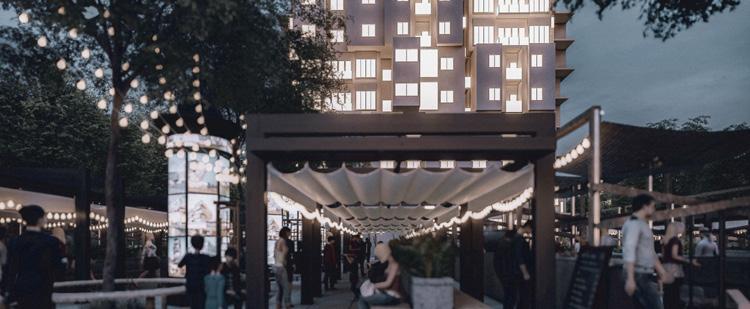
Describing the three major markets within the neighborhood—Cau Muoi, Cau Ong Lanh, and Dan Sinh—the narrative underscores their unique architectural typologies and distinct functions within the community. Despite enduring several fires, the area's fabric remains cluttered and disorderly, exacerbated by the impoverished, under-educated, and often hopeless disposition of its inhabitants.
Amidst these challenges, a visionary concept emerges, proposing unconventional solutions to the pressing spatial constraints. It suggests that public and green spaces transcend traditional horizontal boundaries, existing vertically above the residents' heads. Initially met with skepticism, this innovative idea sparks curiosity and encourages further exploration, hinting at the potential for transformative urban design interventions.
Through informed urban planning, community engagement, and innovative design approaches, the potential for disaster can be mitigated, paving the way for a more resilient and livable urban environment.


Gridscape: Cubiform Communities MARKET STALL BEFORE FIRE IMPROMPTU REDEVELOPMENT EXISTING STRUCTURES INNOVATIVE INFORMALITY
By restructuring each floor into 3.6x3.6x3.6 (m3) cubes, existing "houses" can accommodate more diverse functions within the flexible volume. These multi-functional blocks serve as lifestyle hubs, strategically positioned near the Ben Nghe canal. Integrated green spaces enhance social cohesion and regulate microclimates. Organized on a 3.6x3.6 (m) grid, pedestrian bridges facilitate safe passage. This innovative approach promises to enhance urban functionality and livability.


University of Architecture of Ho Chi Minh City, Institute of International Education, Department of Urban Design Fifth Year, First Semester, March to June 2022
Studio on Urban Design (School Course Name: Synthetic Urban Design)
Location Hoa Hung Locomotive Factory, District 3, HCMC, Vietnam
Area Approx. 50 hectares (or 123.5 acres)
Supervisor(s)
PhD. TRAN Mai Anh
Collaborator(s) HUYNH Dai Nghia
Individual Role Researching and Mapping, Master Planning, Lead Designer, Prototyping, Final Production
Ho Chi Minh City, a pulsating metropolis with a rich history spanning over three centuries, stands as the beating heart of Vietnam's economic prowess. Anchored by a vital railway system that traverses from the northern reaches to the southern tip, the city is on the brink of extending its infrastructural arms further into the labyrinthine network of the Mekong Delta and neighboring Indochina countries. At the nexus of this bustling transportation network lies the iconic Saigon Railway Station, a cultural crossroads and an international gateway, emblematic of the city's dynamism and connectivity.
Within this vibrant tapestry of urbanity, there exists a dichotomy: On one hand, the region boasts a concentrated spatial layout, fostering smaller, enclosed clusters within the neighboring communities. On the other hand, there is an observable trend towards urban sprawl, leading to underutilized spaces particularly evident in the southern periphery near the Locomotive Factory area. Here, amidst the cacophony of progress, lies an opportunity to reimagine the autonomy of typology in urban design.
In the southwestern expanse, a prominent community thrives, steeped in a distinct religious identity that permeates its architecture and social fabric. Contrastingly, the remaining neighborhoods echo a lifestyle typical of railway-adjacent communities, with their own rhythms and nuances. However, the lack of organization has rendered certain spaces redundant, devoid of purpose, and disconnected from the vibrant pulse of the city.
As the city moves forward, bridging the gap between tradition and modernity, the reclamation of unique spaces such as the Locomotive Factory presents an opportunity for renewal. By reimagining these neglected areas as vibrant hubs of activity and innovation, the city can preserve its heritage while embracing the energetic march of progress. In doing so, it not only honors its past but also paves the way for a more inclusive and sustainable future.


Abstract Mapping: The Evolution of the Site 1700s - 1800s


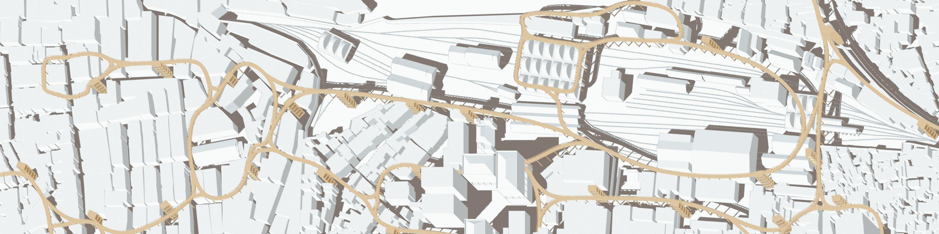
Enter the principles of "Re-(Conduct, Condense, Connect)" – a blueprint for holistic urban renewal and rejuvenation. By weaving geometric splines to form an elevated pathway alongside the locomotive factory and surrounding communities, the city not only enhances physical connectivity but also fosters a spirit of collaboration and cooperation among these disparate yet interconnected areas.

To re-conduct
Integrate the unused and abandoned amenities with the larger commercial landscape in the total public realm, transforming them into vibrant hubs of activity and interaction

1. Define all types of contours, limits and irreplaceable lines to understand the shape and syntax of the land, easily developing the spread and succinctness of the design.
2. Determine the most important boundary contour connecting the seven areas and existing around the locomotive factory area.
5. Soften the corners of these convex lines with higher-degree splines so that directional movement is clear to ensure transparency and flexibility for the High Line model. INTERLINKING

LEVEL 5 +20.00 (m) TECHNICAL ROOM
LEVEL 4 +15.00 HIGH LINE ENTRANCE
LEVEL 3 +10.00 VIEWING PLATFORM
LEVEL 2 +05.00
LEVEL 1 ±00.00 IMMEDIATE UMBRAGE
3. Identify the key points that are vibrant hubs that create the dynamism of all communities. Find a way to connect them to the central line defined in step 2 to form a mesh system.
4. Based on existing figures on the background. Trace the lines defined in step 3 into convex and concave lines to create a vertices system that creates the foundation for the next step.

Tracing Communities Mosaics
The plans reveal the urban morphology and the spatial ranges of alleys which serve as the arteries through which the lifeblood of urban interaction flows. These alleys also delineate the borders of neighborhoods, carving out clusters of identity and belonging. Lines etched in concrete and cobblestone become immutable markers, defining and refining the contours of community. Amidst this intricate network, the communities all converge around the neglected Locomotive Factory, a relic of bygone industrial prowess now a focal point for collective memory and shared aspirations.
To re-condense
Soften the boundaries by redesigning the urban core, blurring the lines between public and private realms to encourage communal engagement

Reinforce the spatial structure by creating a rigid network of seven communities within the Hoa Hung neighborhood, facilitating seamless connectivity To re-connect

University of Architecture of Ho Chi Minh City, Institute of International Education, Department of Urban Design Fifth Year, Last Semester, November 2022 to April 2023
Graduation Project
Top Graduation Score, UAH-KU Leuven, BAUD 2018 - 2023
Location Long Thanh Airport, Long Thanh District, Dong Nai, Vietnam Design Area Approx. 1800 hectares (or 4447.9 acres)
Prototyping City Approx. 100 hectares (or 247.1 acres)
Supervisor(s) PhD. TRAN Mai Anh (Design Advisor), PhD. VU Thi Hong Hanh (Research Advisor) Individual Work
Amidst the excitement of economic growth and infrastructure development, some critical considerations have been overlooked. The current plans for Long Thanh International Airport (LTIA) are inefficient in the provisions for addressing environmental conservation and the preservation of indigenous livelihoods. The rapid clearing of forests to make way for airport construction and urban expansion underscores the need for a more balanced approach to development. While it's undeniable that LTIA promises substantial economic benefits, it's imperative to question whether rapid profitability should come at the expense of long-term sustainability. Can the development of
LTIA be aligned with the preservation of Dong Nai province's rich indigenous heritage and natural landscapes? By incorporating sustainable practices, such as green infrastructure, habitat restoration, and community-driven initiatives, LTIA has the potential to not only boost economic growth but also serve as a model for environmentally responsible development.
In summary, this is an opportunity to adopt future-ready approaches to the integration of a state-of-the-art facility into a healthy context.


The Airfront's Green Strip
The LTIA's construction has significantly altered the physical landscape, affecting river tributaries and disrupting natural drainage systems. To mitigate flood risks and ensure the airport's resilience, an inclusive urban design strategy is crucial. This entails adjusting municipal borders, aligning transportation infrastructure with the terrain, and creating a green zone that serves as flood-resistant storage and vital ecological space for the airport and surrounding urban ecosystem.


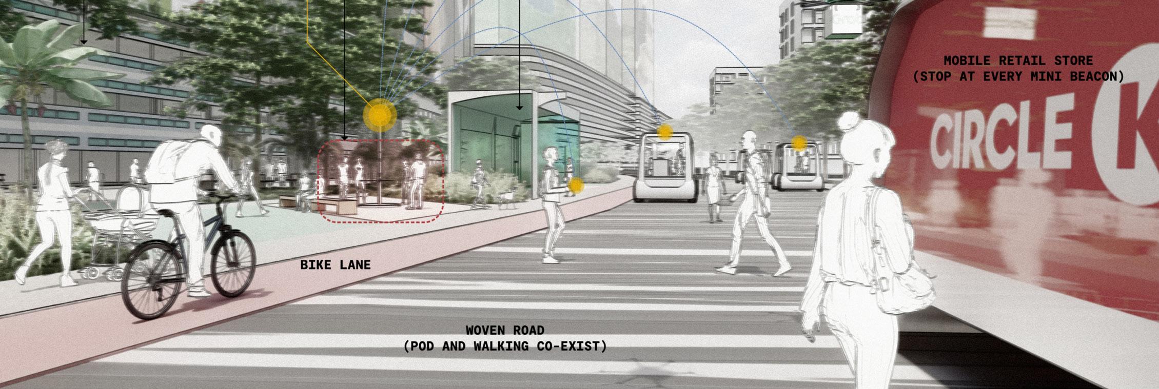
Through AI generative design, vast arrays of possibilities are thoroughly explored, enabling algorithms to generate and evaluate countless iterations based on specified parameters. This iterative process not only accelerates the design exploration phase but also unveils novel solutions that may have remained undiscovered through traditional methods alone.
Parametric design further enriches the toolkit, allowing for the creation of dynamic, responsive designs that adapt to varying conditions and constraints. By establishing a network of interdependent parameters, designs are empowered to evolve organically, with the ability to consider these solutions as part of the final design.
In the final design process, the elements of parametric analysis are assembled into a comprehensive urban fabric. The plan is then enhanced with streetscapes and public spaces that benefit from advances in urban mobility and an elevated quality of the workplace.
I. Initial massing inputs
II. Iteration #1: Rectilinear Layout
III . Iteration #2: Fluid Architectural Forms
IV. Iteration #3: Interwoven Streets
The AI model generated over 30 additional iterations, but these 3 are amongst the most significant. This demonstrates the efficiency of this process in contributing to the design phase.


STUDIO URBAN DESIGN VIETNAM
March to June 2024
Professional Urban Design Practice
Location An Ninh Tay Township, Duc Hoa District, Long An, Vietnam Area Approx. 1150 hectares (or 2841.7 acres)
Supervisor(s) Mr. Steven Morris TOWNSEND (Executive Director of STUDIO URBAN DESIGN VIETNAM)
Individual Role Proofreading issues related to previous Technical Background, Enhancing Master Plan Framework, Creating a Graphic Design Platform for the Urban Design Diagrams

Master Plan Vision
The ink on the tracing paper is delicate: the plan must preserve those qualities of the physical environment and enhance those elements that lead to establishing higher investment value. The plan must respond to the regional activities that are underway and a crucial to ensure the southern economic regions economic success.
The challenge for the masterplanning team of is unique in this application: an engineered solution of efficient building


deployment will reduce the long-term valuation and miss the opportunities that the site has shown us. Instead, this plan must be a carefully woven tapestry of ecological responsibility, cultural respect, and a more strategic placement of new and utilization that integrates all features into a comprehensive new community.
Long An Eco Centre sets a new paradigm that elevates the quality of life on an inclusive platform respectful of the Spirit of Place.


STUDIO URBAN DESIGN VIETNAM
July to September 2024
Professional Urban Design Practice
Location Eastern HCMC Metropolitan Area, HCMC, Vietnam Area Approx. 90 hectares (or 222.3 acres)
Supervisor(s) Mr. Steven Morris TOWNSEND (Executive Director of STUDIO URBAN DESIGN VIETNAM)
Individual Role Lead Urban Designer, Enhancing Master Plan Framework, Design Illustrator
of Connectivity
As a link between Saigon's eastward expansion and the potential servicing threshold of the new Long Thanh International Airport, Nhon Trach becomes an ideal setting for a broad mix of lifestyle and associated services.
The Studio's masterplan captures the visual accessibility provided by Ring Road 3 and the proposed extension of Metro Line 2, incorporating a robust commercial, shopping, and entertainment destination.
The existing riverways are protected as part of the area's heritage and provide natural recreation amenities for the connected, walkable neighborhoods.
The composition of the frontage includes medical office linked to an adjacent regional medical centre, business hotel, vibrant retail destination, and high density urban residential. The combination of uses increases the viability of the retail services and promotes a balance of commerce and lifestyle focused on entertainment leisure.


As Saigon’s Eastward Expansion meets the transformative potential of Long Thanh International Airport, the Eastern districts emerge as a pivotal link in Vietnam’s urban future. Our Studio’s masterplan envisions this dynamic Transit-Oriented Development (TOD) as a vibrant nucleus of commerce, recreation, and community.
Key highlights:
Seamless integration of Ring Road 3 and the proposed Metro Line 2 extension, amplifying connectivity.
A thriving hub for commercial, shopping, and entertainment that anchors the region.
Preservation of existing riverways, blending heritage with accessible, natural recreation for all.
Walkable neighborhoods designed to foster community and sustainable lifestyles.


STUDIO URBAN DESIGN VIETNAM
October to December 2024
Professional Urban Design Practice
Location Highspeed Railway Site, District 2, HCMC, Vietnam
Area Approx. 64 hectares (or 158.1 acres)
Supervisor(s) Mr. Steven Morris TOWNSEND (Executive Director of STUDIO URBAN DESIGN VIETNAM)
Individual Role Lead Architect, Lead Urban Designer, Assisting Master Planner

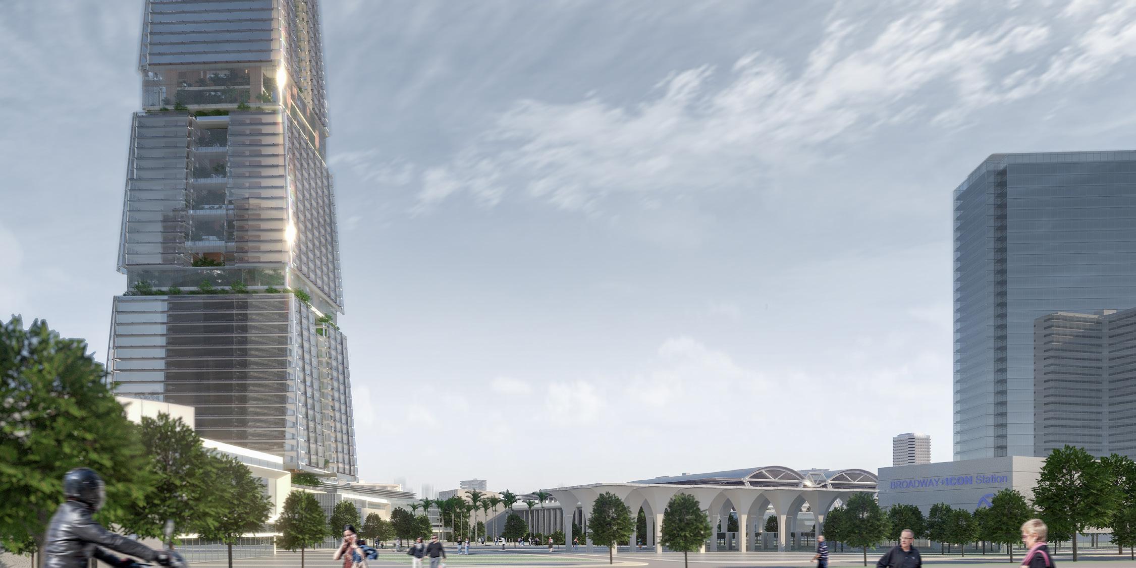
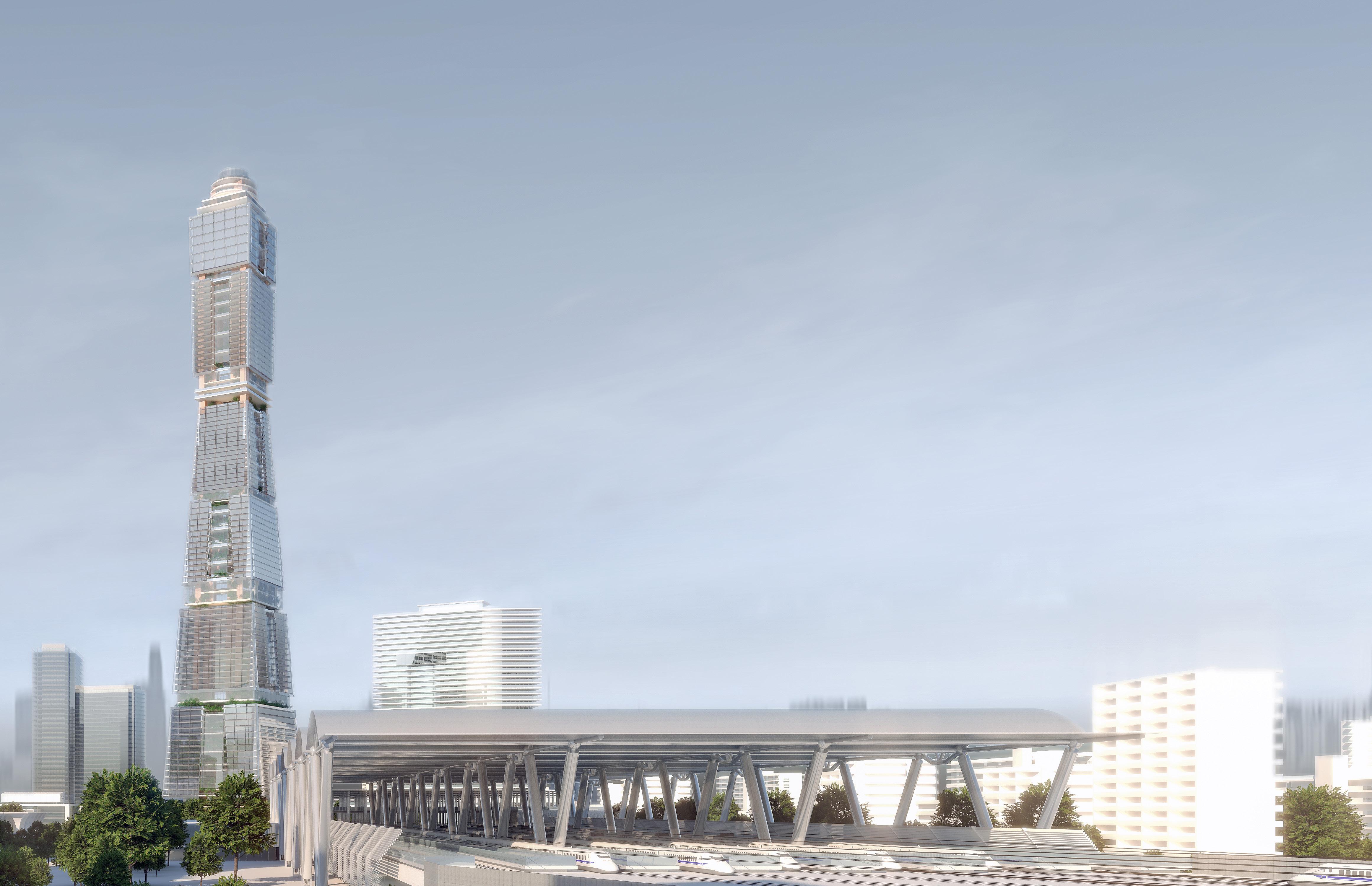
At STUDIO URBAN DESIGN VIETNAM, we’re proud to present Broadway Icon: our latest project that reimagines mixed-use development as a sustainable vertical city. Vietnam’s economic powerhouse—Saigon (formerly Ho Chi Minh City)—is a metropolis where historic charm meets rapid urbanization. As the country’s largest city, it thrives as a key hub for commerce, finance, and culture in Southeast Asia.
Once centered around its historic core, Saigon now shifts its gaze eastward, embarking on a transformation that redefines its identity and role in regional and global contexts. This eastern expansion is not just about geography—it’s about connection and integration. Thoughtful planning ensures these new districts remain tied to Saigon’s vibrant cultural heart, seamlessly blending tradition with cutting-edge design.
Enter Broadway Icon: a skyscraper that reimagines mixed-use development as a sustainable vertical city.
Three distinct “neighborhoods”: Dedicated spaces for innovation, commerce, and leadership, meeting the growing demand for integrated work and lifestyle environments.
Clean energy leadership: Solar-harvesting window walls and thermoelectric generators generate over 65 GWh annually— powering the tower and the adjacent High-Speed Rail Station.
Innovative design: Rotating floor stacks and natural ventilation systems optimize light, airflow, and energy efficiency, minimizing the building’s environmental footprint. Community-centered spaces: Central atriums promote social interaction, fostering collaboration and connection.
Broadway Icon is more than a building—it’s a statement for Saigon’s future. It connects communities, preserves local culture, and sets new benchmarks for sustainable urban living. As the city expands eastward, this landmark will play a pivotal role in shaping the next
of Saigon’s growth story.
Broadway Icon is more than a skyscraper—it’s a vertical ecosystem, blending work, living, and recreation across three neighborhoods: Innovation, Commercial, and Executive. Divided into 12 distinct districts, the tower redefines urban living with:
Workplace Districts: Offices and coworking hubs.
Residential Districts: Dynamic living spaces.
Sky Deck Districts: Elevated green parks for community and relaxation.
Seamless navigation is ensured through two Elevated Lobby Districts for Commercial and Executive zones, and a Master Lobby at ground level, orchestrating movement across all 102 stories.
At its core, Broadway Icon’s solar-harvesting facade sets a new standard for renewable energy integration:
Sun-Tracking PV Cells: A dynamic facade maximizes solar energy capture.
Perovskite Solar Films: Semi-transparent films convert sunlight into electricity without blocking views.
TEG-PCM Modules: Thermoelectric systems generate power while stabilizing interior climates.


Architect / Urban Design Practitioner
Full
CAO Tran Phong Tuan
Nationality
Vietnamese
Contact
viettuan1982000@gmail.com
(+84) 9 49 59 11 63
Education
Bachelor of Urban Design (BAUD)
Transnational Education Program of:
+ University of Architecture of Ho Chi Minh City (UAH)
+ Katholieke Universiteit Leuven (KU Leuven)
2018 - 2023
Institute of International Education (IEI) Department of Urban Design
Graduated with Honors
Advanced Grade Point Average 03.64 / 04.00
Top Graduation Project score of the class 08.90 / 10.00
Graduation Project Instructors:
+ PhD. TRAN Mai Anh
+ PhD. VU Thi Hong Hanh
Language Vietnamese Native English
C1 - C2 Proficiency
TOEIC 935
TOEFL 96
Japanese N5
Visual AutoCAD-Civil 3D
3DS Max
Rhinoceros 3D-Grasshopper SketchUp Blender Revit-Dynamo ArchiCAD
Professional Experience
Architectural Intern
AZ Architects, Ho Chi Minh City
2019/01-08
Assisted Senior Architect DANG Tuan Anh in rendering, creating and organizing drawings for several multi-scale residential housing projects
Architectural Intern
GIBACO Architects, Ho Chi Minh City
2021 - 2022
Assisted Principal Architect TRUONG Song Truong (LEED AP) in rendering and creating drawings for several multi-scale public, residential and service buildings
Co-Founder, Head Mentor
ROOSTERS by Tuan Cao, Ho Chi Minh City 2022 - 2023
Launched a series of specialized courses on softwares and design principles tailored for architecture students
Co-Founder, Independent Practitioner
NADA+, Ho Chi Minh City
2023/01-10
Founded a local boutique architectural firm called NADA+ with my close partner HUYNH Dai Nghia, specializing in small-scale vernacular housing, hospitality, and retail projects
Urban Designer
STUDIO URBAN DESIGN VIETNAM, Ho Chi Minh City
2023 - 2024

Slicing, Post-processing)
Employed as a professional urban designer under the guidance of Mr. Steven Morris Townsend, Director and Founder of STUDIO URBAN DESIGN LIMITED (Hong Kong), contributing to various urban design projects in Vietnam and participating in several seminars at the University
Architecture Department Co-Founder, Head Mentor Math and Science Summer Program 2020 - 2023
Founded the Architecture Department within the Math and Science Summer Program (MASSP), a summer school initiated by Vietnamese former PhD candidates at MIT, dedicated to offering career guidance to students in Vietnam. Held the primary role within the Department for a duration of four years
Representative Student for IEI, UAH Sakura Science Exchange Program (SSP) Tokyo City University (TCU) - Department of Urban Life 2023
Participated as a student delegate from the Institute of International Education at the University of Architecture of Ho Chi Minh City in workshops, seminars, and competitions on Urban Design hosted by the Department of Urban Life at the Tokyo City University for a duration of one month, focusing on the theme of “Enhancing Urban Development in the Lower Futako-Tama River Area.”
First Author of Research Paper Asia-Pacific Planning Societies (ICAPPS) 2023
Participated in the ICAPPS 2023 Conference presenting a Research Paper focused on Urban Mapping titled “Spatial Interdependence of Transit Hubs: Examining DevelopmentInduced Displacement Effects on Pedestrian Behavior near Ben Thanh Market, Ho Chi Minh City”
Top graduation project score
Bachelor of Urban Design (BAUD)
Transnational Education Program of: + University of Architecture of Ho Chi Minh City (UAH) + Katholieke Universiteit Leuven (KU Leuven)
2023
Earned the top Final Score for the Bachelor of Urban Design Graduation Project titled “Urban Design of Long Thanh Airport City,” in the graduating Urban Design class of 2018 - 2023
Third Place
National Competition “Urban Planning for HCMC in 2040” Department of Architecture and Urban Planning of HCMC 2022
Secured the Third Place in the National Competition titled “Urban Planning for HCMC in 2040,” hosted by the Department of Architecture and Urban Planning of HCMC, under the Ministry of Construction of Vietnam, with the project titled “The New Port de Saïgon”


https://linktr.ee/caotuan_harvard_ud


