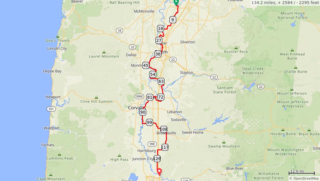
Willamette Valley Scenic Bikeway
Num Dist Prev Type Note Next 1. 0.0 0.0 Start of route 0.0 2. 0.0 0.0 East on Champ oeg Rd from park entranc e Scenic Bikeway route starts at the entrance to Champo eg State Heritage Area, water and camping available in park 0.9 0.0 miles. +0/-0 feet Num Dist Prev Type Note Next 3. 0.9 0.9 Bear R on Case Rd Butteville Store 2.4 miles off route east (left) 1.4 4. 2.3 1.4 Straight on Case Rd at McKay/ Yergen Rds CAUTIO N: High speed cross traffic 2.1 5. 4.4 2.1 R on St Paul Hwy 0.6 4.3 miles. +40/-5 feet Num Dist Prev Type Note Next 6. 4.9 0.6 L on Arbor Grove Rd 3.1 7. 8.0 3.1 L on OR-219 (signs for Woodb urn) CAUTIO N: High speed cross traffic. Two confusing intersecti ons in a row. Continue in a north or south direction. 0.2 3.6 miles. +28/-29 feet Num Dist Prev Type Note Next 8. 8.2 0.2 R on Arbor Grove Rd/Dec oninck Rd/Man ning Rd 4.0 9. 12.2 4.0 R on Keene Rd 1.3 10. 13.4 1.3 L on River Rd 1.5 11. 14.9 1.5 R on Mathen y Rd 3.1 7.0 miles. +33/-23 feet
Num Dist Prev Type Note Next 12. 18.1 3.1 Straight on Wheatl and Rd Wheatlan d Ferry and multi-use path entrance into Willamett e Mission State Park 0.5 miles west (right on Matheny Rd) 0.8 3.1 miles. +0/-0 feet Num Dist Prev Type Note Next 13. 18.9 0.8 Straight at Willame tte Mission State Park entranc e. Water, restroom s, hikerbiker, and group camping in park 1.2 miles from entrance 2.8 0.8 miles. +0/-0 feet Num Dist Prev Type Note Next 14. 21.7 2.8 R on Ravena Dr CAUTIO N: This turn is easy to miss. Look for downhill. 1.1 15. 22.8 1.1 L on Salmon St/9th Ave/Si mon St 0.9 16. 23.7 0.9 L on Windso r Island Rd 4.4 17. 28.2 4.4 Straight on Shoreli ne Dr 0.7 9.3 miles. +55/-78 feet Num Dist Prev Type Note Next 18. 28.9 0.7 L on Manbri n Dr 0.5 19. 29.4 0.5 R on Cherry Ave Keizerstores, restauran ts, lodging 1.2 20. 30.7 1.2 R on Auto Group Ave 0.2 21. 30.9 0.2 L on Maple St 0.1 2.7 miles. +11/-13 feet
Num Dist Prev Type Note Next 22. 31.0 0.1 Straight on multiuse path to continu e on Maple St 0.8 23. 31.8 0.8 L on South St 0.0 24. 31.8 0.0 R on Cottage St 0.2 25. 32.0 0.2 L on Norway St 0.1 26. 32.1 0.1 R on Winter St 1.0 1.2 miles. +16/-0 feet Num Dist Prev Type Note Next 27. 33.1 1.0 Straight into Willson Park Salemstores, restauran ts, lodging 0.0 28. 33.2 0.0 Continu e past circle of state flags State Capitol Bldg on left 0.0 29. 33.2 0.0 Straight to exit Willson Park to Winter St 0.5 1.1 miles. +0/-0 feet Num Dist Prev Type Note Next 30. 33.7 0.5 Straight to enter Bush's Pasture Park 0.0 31. 33.8 0.0 Straight on multiuse path 0.2 32. 34.0 0.2 L on multiuse path 0.2 33. 34.2 0.2 Straight on Yew St to exit park 0.0 34. 34.2 0.0 R on Cross St 0.4 1.0 miles. +18/-5 feet Num Dist Prev Type Note Next 35. 34.6 0.4 R on High St 0.1 36. 34.7 0.1 L on Myers St 0.2 37. 34.9 0.2 R on Sagina w St 0.1 38. 35.1 0.1 L on Miller St 0.2 39. 35.3 0.2 Continu e onto multiuse path on east side of River Rd 0.9 1.0 miles. +5/-46 feet
Num Dist Prev Type Note Next 40. 36.2 0.9 Cross River Road at entranc e to Minto Brown Island Park to continu e south on River Rd Restroom s in park 0.2 miles west 8.8 0.9 miles. +0/-0 feet Num Dist Prev Type Note Next 41. 44.9 8.8 R on Riversid e Dr to pass under bridge and continu e south Independ encestores, restauran ts 0.8 mile over bridge 5.7 42. 50.6 5.7 R on Sidney Rd 1.9 43. 52.5 1.9 R on Buena Vista Rd 3.6 16.3 miles. +257/-213 feet Num Dist Prev Type Note Next 44. 56.1 3.6 L on Talbot Rd Buena Vista Ferry 0.3 mile off route right on Buena Vista Rd 2.6 45. 58.7 2.6 Continu e on Talbot Rd Talbot 2.5 46. 61.2 2.5 Bear R after crossin g I-5 to continu e on Talbot Rd 2.9 8.7 miles. +60/-26 feet Num Dist Prev Type Note Next 47. 64.1 2.9 R on OR164/2n d St 1.2 48. 65.3 1.2 Bear R to continu e on Jefferso n Hwy/O R-164 Jefferson - stores, restauran ts 1.2 49. 66.4 1.2 L on Scravel Hill Rd Begin 1mile climb, pioneer cemetery at top 5.8 5.3 miles. +26/-55 feet
Num Dist Prev Type Note Next 50. 72.2 5.8 R on US-20 CAUTIO N: High speed traffic, prepare for immediat e left turn 0.1 51. 72.3 0.1 L on Kennel Rd 1.7 52. 74.0 1.7 R on Grand Prairie Rd 2.4 53. 76.4 2.4 R on Geary St 1.6 10.0 miles. +43/-59 feet Num Dist Prev Type Note Next 54. 78.0 1.6 L on 1st Ave/Cal apooia St 1.5 55. 79.4 1.5 R on 3rd Ave Albanystores, restauran ts, lodging 0.1 56. 79.6 0.1 L on Bryant Way 1.2 57. 80.7 1.2 L on Bryant Dr 0.9 4.3 miles. +39/-56 feet Num Dist Prev Type Note Next 58. 81.7 0.9 L to continu e on Bryant Dr 0.4 59. 82.1 0.4 R on Riversid e Dr 5.3 60. 87.4 5.3 R on OR-34 0.3 6.7 miles. +36/-27 feet Num Dist Prev Type Note Next 61. 87.6 0.3 L on White Oak Rd If uncomfor table crossing OR-34, continue 1.6 mile to traffic light at Peoria Rd, turn left, and rejoin route at milepoint 87.9 1.8 62. 89.4 1.8 L on Peoria Rd 5.9 63. 95.4 5.9 L on Fayette ville Dr 5.1 8.0 miles. +94/-67 feet
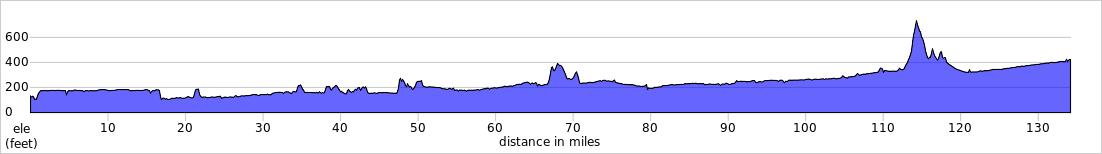
Num Dist Prev Type Note Next 64. 100.5 5.1 Continu e onto Boston Mill Dr 1.3 65. 101.7 1.3 R on Roberts Rd Thompso n Mills State Heritage Site 0.3 mile on Boston Mill Rd 3.0 66. 104.7 3.0 L on Linn W Dr 2.2 67. 106.9 2.2 Straight on 7 Mile Ln 2.5 68. 109.4 2.5 L on Depot Ave 0.1 14.1 miles. +111/-51 feet Num Dist Prev Type Note Next 69. 109.5 0.1 R on Main St Brownsvil lestores, restauran ts, lodging 0.2 70. 109.7 0.2 L on Stanard Ave 0.0 71. 109.8 0.0 R on Main St 0.5 72. 110.3 0.5 R on OR-228 0.1 73. 110.4 0.1 L on Washb urn St/Gap Rd 4.0 0.9 miles. +12/-29 feet Num Dist Prev Type Note Next 74. 114.4 4.0 Continu e on Gap Rd Elevation 740 feethighest point on Willamett e Valley Scenic Bikeway 4.1 75. 118.4 4.1 Straight on Diamon d Hill Dr 3.1 76. 121.5 3.1 L on Coburg Rd 9.8 77. 131.3 9.8 L on Van Duyn St 0.2 20.9 miles. +228/-542 feet Num Dist Prev Type Note Next 78. 131.5 0.2 R on Willame tte St Coburgstores, restauran ts 2.7 79. 134.1 2.7 End of Scenic Bikewa y Scenic Bikeway route ends at Armitage County Park 0.0 80. 134.2 0.0 End of route 0.0 2.9 miles. +46/-23 feet