
Test Bank for
Exploring Geology 4th Edition by Reynolds
Johnson Morin Carter
ISBN 0078022924 9780078022920
Full link download:
Test Bank:
https://testbankpack.com/p/test-bank-for-exploring-geology-4th-edition-by-reynoldsjohnson-morin-carter-isbn-0078022924-9780078022920/
Solution Manual:
https://testbankpack.com/p/solution-manual-for-exploring-geology-4th-edition-by-reynoldsjohnson-morin-carter-isbn-0078022924-9780078022920/
Chapter 2 – Investigating Geologic Questions
TEST BANK QUESTIONS – This test bank is for Exploring Geology 4th edition. In addition to this Word file, the questions can be accessed via MH’s Connect system, and MH can provide them for various classroom-management systems (e.g., Blackboard).
At the end of this document are instructions for copying and pasting these questions to create a new test, as well as a description the self-numbering character of the questions and answers using Styles in Microsoft Word. Short descriptors that follow each question are summarized here:
• Answer: Correct answer to question.
• Section: The number of the relevant two-page spread in Exploring Geology, 4th edition.
• Difficulty Level: Cognitive skills required to answer the question, selected from six categories in a version of Bloom’s Taxonomy. The six categories are Remember, Understand, Apply, Analyze, Evaluate, or Create
• Topic: The chapter or the part of a chapter (e.g., energyresources versus mineral resources) to which the question applies.
Section 2.0 – Investigating Geologic Questions
1. What was the main mystery described for the Mediterranean Sea?
a) A volcanic eruption destroyed the ancient cityof Alexandria.
b) A meteorite formed the western Mediterranean Sea.
c) The Mediterranean dried up and deposited layers of salt.
d) A large landmass collapsed downward, forming the sea.
Answer: c
Section: 2.0
DifficultyLevel: Remember/Understand
Topic: Investigating Geologic Questions
2. The Mediterranean Sea is connected with the Atlantic Ocean through the: a) Strait of Gibraltar
b) Red Sea
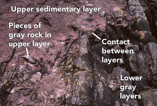
c) Nile River
d) BlackSea
Answer: a
Section: 2.0
DifficultyLevel: Remember/Understand
Topic: Investigating Geologic Questions
3. Beneath the Mediterranean Sea, large deposits of salt and layers of wind-deposited sand dating from around 6 million years ago are present. Which of the following would you conclude based upon this information?
a) The Mediterranean Sea once evaporated, leaving behind large salt deposits and creating a desert-like environment of wind-blown sands
b) The Mediterranean Sea was once deeper than at present, depositing large amounts of salt and layered sand
c) The environment within the Mediterranean Sea has not changed from 6 million years ago to today.
d) Sand and salt have blown into the Mediterranean Sea from the surrounding desert areas
Answer: a
Section: 2.0
DifficultyLevel: Remember/Understand
Topic: Investigating Geologic Questions
Section 2.1 – Observing Landscapes
4. Which locations are composed of loose materials (not bedrock)?

a) 1 and 2
b) 2 and 3
c) 3 and 4
d) 1 and 3
e) 2 and 4
a)
b)
Answer: c
Section:2.1
DifficultyLevel: Apply/Analyze
Topic: Nature of Geology
5. Which location(s) have loose, angular rocks?
a) 1
b) 2
c) 3
d) 4
e) 1 and 2
Answer: c
Section:2.1
DifficultyLevel: Apply/Analyze
Topic: Nature of Geology
6. Which locations contain rocks that are in place (part of the bedrock)? 1 and 2 2 and 3
d) 1 and 3
e) 2 and 4
c) 3 and 4
Answer: a
Section:2.1
DifficultyLevel: Apply/Analyze
Topic: Nature of Geology
7. Which locations consist of sediment rather than sedimentary rocks? a) 1 and 2
b) 2 and 3
c) 3 and 4
d) 1 and 3
e) 2, 3, and 4
Answer: c
Section:2.1
DifficultyLevel: Apply/Analyze
Topic: Nature of Geology
8. What are some components of the landscape shown in this photograph?
a) a natural stain on the outside of the rocks
b) fractures and layers
c) loose rocks covering a slope-forming unit
d) rounding of the upper parts of the cliff

e) all of these
Answer: e
Section:2.1
DifficultyLevel: Remember/Understand
Topic: Investigating Geologic Questions
9. Which of the following is NOT a recommended strategy for observing a landscape?
a) Observe the entire landscape first and then focus on smaller parts, one part at atime.
b) Examine complexities of each feature rather than grouping features into types.
c) Focus on one type of feature at a time, noting where this type of feature is present.
d) Examine relationships between different features.
Answer: b
Section: 2.1
DifficultyLevel: Remember/Understand
Topic: Investigating Geologic Questions
10. The vertical black lines indicated in rock units #3 and #4 indicate what type of feature?
a) fractures
b) beddings
c) slopes
d) loose rock
Answer: a
Section:2.1
Difficulty Level: Remember/Understand Apply/Analyze Evaluate/CreateTopic: Investigating Geologic Questions
11. What shape are the pebble-sized particles that make up the rock? a) rounded

b) angular
Answer: a
Section:2.1
Difficulty Level: Apply/Analyze Topic: Investigating Geologic Questions
12. This indicates to us that the environment in which this rock formed was likely:

a river channel a steep mountain front
Answer: a
Section:2.1
Difficulty Level: Apply/Analyze
Topic: Investigating Geologic Questions
13. Rocks that are more resistant to erosion are more likely to create: a) cliffs
b) slopes
c) ledges
Answer: a
Section: 2.1
DifficultyLevel: Remember/Understand
Topic: Investigating Geologic Questions
14. Rocks that are easy to erode often create:

a) slopes
b) ledges
c) cliffs
Answer: a
Section: 2.1
DifficultyLevel: Remember/Understand
Topic: Investigating Geologic Questions
Section 2.2 – Interpreting Geologic Clues
15. The sediment in this photograph most likely formed in:
a) a steep mountain front
b) a river
c) a sand dune
d) deep water conditions on the seafloor
b)
Answer: b
Section:2.2
DifficultyLevel: Apply/Analyze
Topic: Nature of Geology
16. The sediment in this photograph mostly likely formed in:


a) a steep mountain front
b) a river
c) a sand dune
d) deep water conditions on the seafloor
Answer: a
Section:2.2
DifficultyLevel: Apply/Analyze
Topic: Nature of Geology
17. The rock in this photograph mostly likely formed in:
a) a steep mountain front
b) a river
c) a sand dune

d) deep water conditions on the seafloor
Answer: b
Section:2.2
DifficultyLevel: Apply/Analyze
Topic: Nature of Geology
18. What is the youngest unit or feature in this figure?
a) 1
b) 2
c) 3
d) 4
e) there is no wayto tell
Answer: d
Section:2.2
DifficultyLevel: Apply/Analyze
Topic: Nature of Geology
19. What is the oldest unit or feature in this figure? 1 2
c) 3
d) 4
e) there is no wayto tell
Answer: c
Section:2.2
DifficultyLevel: Apply/Analyze
Topic: Nature of Geology
20. What is the oldest unit or feature in this figure? a)1
b)2
c)3
d)4
e)Answer: d 5
Section: 2.2
DifficultyLevel: Apply/Analyze
Topic: Nature of Geology
21. What is the youngest unit or feature in this figure?
a)1
b)2
c)3
d)4
e)5
Answer: e
Section:2.2
DifficultyLevel: Apply/Analyze
Topic: Nature of Geology

22. The youngest unit or feature in this photograph is:
a) the rock at the top that contains angular fragments
b) the gray layer in the middle of the photograph
c) the tilted rocks at the bottom
d) there is no wayto tell
Answer: a
Section:2.2
DifficultyLevel: Apply/Analyze
Topic: Nature of Geology
23. The oldest unit or feature in this photograph is:
a) the rock at the top that contains angular fragments
b) the gray layer in the middle of the photograph
c) the tilted rocks at the bottom

d) there is no wayto tell
Answer: c
Section:2.2
DifficultyLevel: Apply/Analyze
Topic: Nature of Geology
24. What strategy was described for inferring the environment in which a rock formed?
a) smashing the rock into pieces to see whether it breaks into square or rounded pieces
b) comparing the characteristics of the rock to deposits from modern environments
c) imagining what would happen if the rock was metamorphosed
d) all of these
Answer: b
Section: 2.2
DifficultyLevel: Remember/Understand
Topic: Investigating Geologic Questions
25. The phrase trading location for time signifies that:
a) It takes more time to observe a landscape than is available.
b) Expensive homes are built in locations that cost people time.
c) Different parts of a landscape can be used to infer how the landscape changes over time.
d) Some rocks are harder than others to erode and so last a longer time.
Answer: c
Section: 2.2
DifficultyLevel: Remember/Understand
Topic: Investigating Geologic Questions
26. Which of the following is a principle to interpret relative ages?
a) The youngest rock is on the bottom.
b) A geologic feature is older than any rock or feature it crosscuts.
c) A younger rock can include pieces of an older rock.
d) An older magma can bake or metamorphose younger rocks.
Answer: c
Section: 2.2
DifficultyLevel: Remember/Understand
Topic: Investigating Geologic Questions
27. What order did the rock layers and features form in this photograph (listed from oldest to youngest)?
a) upper layer, fracture, middle layers, lowest layer
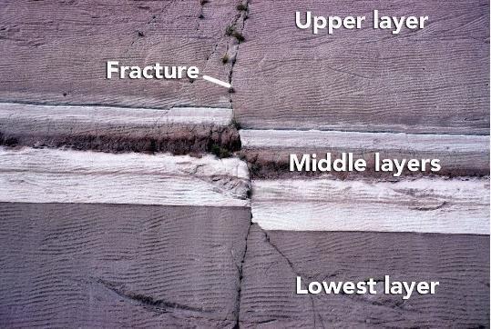
b) lowest layer, middle layers, fracture, upper layer
c) lower layer, middle layers, upper layer, fracture
d) none of these
Answer: c
Section:2.2
Difficulty Level: Apply/Analyze
Topic: Investigating Geologic Questions
28. What can you interpret about the relative age of the rocks and features in this photograph? a) The upper sedimentary layer is younger.
b) The lower gray layers are younger.
c) The layers are the same age because the boundary is so irregular.
d) It is not possible to tell the relative ages of the layers.
Answer: a
Section:2.2
Difficulty Level: Apply/Analyze
Topic: Investigating Geologic Questions
29. What is the best criterion for the relative ages of the rocks in this photograph?
a) The igneous rock is younger because it is on top.
b) The igneous rock is younger because it has baked the adjacent rock.

c) The lower rock is younger because it contains pieces of volcanic rock.
d) The igneous rock is older because it formed at depth.
Answer: b
Section: 2.2
Difficulty Level: Apply/Analyze
Topic: Investigating Geologic Questions
30. Which of the following are valid criteria for inferring the relative ages of the two rock types in this photograph?
a) The black rock is younger because it is on the bottom.
b) The tan rock is younger because it contains pieces of the black rock.

c) The black rock is younger because it is crosscut bythe tan rock.
d) The evidence is contradictoryabout the relative ages of these two rocks.
Answer: b
Section:2.2
Difficulty Level: Apply/Analyze
Topic: Investigating Geologic Questions
31. What can you interpret about the relative ages of the rocks and features in this photograph?
a) The sandstone is older because it is lighter in color.
b) The metamorphic rock is older because it is rougher from longer weathering.
c) The metamorphic rock is older because pieces of it are in the sandstone.

d) The sandstone is older because it is on top.
Answer: c
Section: 2.2
Difficulty Level: Apply/Analyze
Topic: Investigating Geologic Questions
32. What sort of environment would possibly deposit sediment like that seen in the image? a) river channels

b) floodplain
c) steep mountain slope
d) cliff face
Answer: a
Section:2.2
Difficulty Level: Apply/Analyze
Topic: Investigating Geologic Questions
33. The feature shown is a smaller, steep-sided mountain and has had its edges eroded away. This feature would commonly be called a: a) butte
b) mesa
c) knob
Answer: a
Section:2.2
DifficultyLevel: Remember/Understand
Topic: Investigating Geologic Questions
34. The image represents a broad, flat-topped mountain with steep sides. This feature is called a:


a) mesa
b) butte
c) knob
Answer: a
Section:2.2
Difficulty Level: Remember/Understand
Topic: Investigating Geologic Questions
35. Over time, when a mesa becomes a butte and abutte eventually becomes hills and knobs, we can infer what physical process has taken place: a) erosion
b) glaciations
c) river transportation
d) deposition
Answer: a
Section: 2.2
DifficultyLevel: Remember/Understand
Topic: Investigating Geologic Questions
36. The age of a fossil, organism, rock, geologic feature, or event as defined relative to other geologic features or events is the:
a) relative age
b) absolute age
c) numerical age
d) radiometric age
Answer: a
Section: 2.2
DifficultyLevel: Remember/Understand
Topic: Investigating Geologic Questions
37. When a fracture cuts across several rock layers, we can interpret that:
a) the fracture is younger than the layers it crosscuts
b) the fracture is older than the layers it crosscuts
c) the layers of rock are younger than the fracture.
d) the fracture formed at some time prior to the rock layers
Answer: a
Section: 2.2
DifficultyLevel: Remember/Understand
Topic: Investigating Geologic Questions
38. What interpretation can be made from an igneous rock body (such as granite) that has baked or metamorphosed the adjacent rocks?
a) When the granite was molten, the heat from the magma altered the preexisting rocks around it.
b) The adjacent rocks reacted with the solid granite to create a zone of metamorphism. Answer: a
Section: 2.2
DifficultyLevel: Remember/Understand
Topic: Investigating Geologic Questions
39. What kind of map gives detailed information regarding the elevation of the land's surface?
a) topographic
b) shaded relief
c) geologic
d) satellite image
Answer: a
Section: 2.2
DifficultyLevel: Remember/Understand
Topic: Investigating Geologic Questions
40. What map is best for showing detailed geologic information about an area? a) topographic
b) shaded relief
c) geologic
d) satellite image
Answer: c
Section: 2.2
DifficultyLevel: Remember/Understand
Topic: Investigating Geologic Questions
Section 2.3/2.4 – Earth Depicted
41. What type of map is shown here?
a) shaded-relief map

b) topographic map with contours
c) satellite image
d) geologic map
Answer: a
Section: 2.3/2.4
DifficultyLevel: Remember/Understand
Topic: Nature of Geology
42. What type of map is shown here?
a) shaded-relief map
b) topographic map with contours
c) satellite image
d) geologic map
Answer: b
Section: 2.3/2.4
DifficultyLevel: Remember/Understand
Topic: Nature of Geology
43. Which of the following map or diagram would best show you the shape of the land surface?
a) shaded-relief map
b) satellite image
c) geologic map
d) stratigraphic section
Answer: a
Section: 2.3/2.4
Difficulty Level: Apply/Analyze
Topic: Investigating Geologic Questions
44. Which type of map or diagram would best indicate elevation of the land surface? a) shaded-relief map
b) satellite image
c) topographic map
d) stratigraphic section
Answer: c
Section: 2.3/2.4
Difficulty Level: Apply/Analyze
Topic: Investigating Geologic Questions
45. What type of figure would you use to portray the relative thicknesses of rock units stacked on top of one another? a) shaded relief map
b) topographic map
c) satellite image
d) stratigraphic section
e) evolutionary diagram
Answer: d
Section: 2.3/2.4
DifficultyLevel: Remember/Understand
Topic: Investigating Geologic Questions
46. What does the type of evolutionary diagrams discussed in the textbook show?
a) how one creature evolved into another creature
b) changing of fossils up through a stratigraphic section
c) evolution of the ways topographic maps have been drawn during history
d) the sequence of events that deposited the rocks and formed the landscape Answer: d
Section: 2.3/2.4
DifficultyLevel: Remember/Understand
Topic: Investigating Geologic Questions
47. If you wanted to determine how deep a rock layer was below a particular point on the surface, what type of figure would be most useful? a) shaded relief map
b) topographic map
c) satellite image
d) evolutionary diagram
e) geologic cross section
Answer: e
Section: 2.3/2.4
DifficultyLevel: Remember/Understand
Topic: Investigating Geologic Questions
48. What type of map is used primarily to show the shape of the land by simulating light and dark shading on the hills and valleys? a) shaded relief map
b) satellite image
c) geologic map
d) topographic map
Answer: a
Section: 2.3/2.4
DifficultyLevel: Remember/Understand
Topic: Investigating Geologic Questions
49. What specific type of map represents the distribution of rock units and geologic features exposed on the surface? a) geologic map
b) topographic map
c) contour map
d) shaded reliefmap
Answer: a
Section: 2.3/2.4
DifficultyLevel: Remember/Understand
Topic: Investigating Geologic Questions
50. What specific type of image uses measurements of different wavelengths of light reflecting from a land surface to create a computer-processed image to show the distribution of different types of plants, rocks, and other features? a) satellite images
b) geologic map
c) topographic map

d) shaded reliefmap
Answer: a
Section: 2.3/2.4
DifficultyLevel: Remember/Understand
Topic: Investigating Geologic Questions
51. What type of map depicts the shape of the land surface by showing the elevation of the land surface with a series of lines called contours? a) topographic map
b) satellite image
c) shaded relief map
d) geologic map
Answer: a
Section: 2.3/2.4
DifficultyLevel: Remember/Understand
Topic: Investigating Geologic Questions
52. Topographic maps often have some contour lines that are darker than other contour lines. These darker lines are called: a) index contours
b) contour intervals
Answer: a
Section: 2.3/2.4
DifficultyLevel: Remember/Understand
Topic: Investigating Geologic Questions
Section 2.4 – Earth Depicted
53. Which letter on the accompanying figure indicates the elevation? a) A
b) B
c) C
d) D
Answer: b
Section:2.4
DifficultyLevel: Remember/Understand
Topic: Investigating Geologic Questions
54. Which letter on the accompanying figure indicates the amount of topographic relief?
a) A
b) B
c) C
d) D
Answer: c
Section:2.4
DifficultyLevel: Remember/Understand
Topic: Investigating Geologic Questions
55. Which letter on the accompanying figure indicates depth? a) A
b) B
c) C
d) D
Answer: a
Section:2.4
DifficultyLevel: Remember/Understand
Topic: Investigating Geologic Questions
56. Slopes that drop or rise sharply in elevation are:
a) steep
b) plains
c) contours
Answer: a
Section: 2.4
DifficultyLevel: Remember/Understand
Topic: Investigating Geologic Questions
57. Slopes in flatter areas are:
a) gentle
b) elevated
c) cliffs
d) indexes
Answer: a
Section: 2.4
DifficultyLevel: Remember/Understand
Topic: Investigating Geologic Questions
58. Which of the following could be associated with a steep slope?
a) a mountain side
b) a cliff
c) closely spaced contour lines
d) all of these
Answer: d
Section: 2.4
DifficultyLevel: Remember/Understand
Topic: Investigating Geologic Questions
59. Elevation variations in the land's surface might best be represented by a(n):
a) topographic profile
b) geologic map
c) outcrop
Answer: a
Section: 2.4
DifficultyLevel: Remember/Understand
Topic: Investigating Geologic Questions
60. This image would be best used in what situation?
a) A petroleum company wants to know if any geologic structures in the area could contain oil pools.
b) The thickness of the surface layer of rock needs to be determined for a construction site.
c) The average gradient for a particular area needs to be known to studysurface runoff.
Answer: c
Section:2.4
Difficulty Level: Apply/Analyze
Topic: Investigating Geologic Questions
61. Which of the following are true for an evolutionary diagram?
a) Uses a sequence of geologic diagrams to depict the geologic historyof an area.

b) Mayuse block diagrams, cross sections, or maps.
c) Shows the progression of changes an area undergoes through time.
d) All of these.
Answer: d
Section: 2.4
DifficultyLevel: Remember/Understand
Topic: Investigating Geologic Questions
62. Which of the following may be interpreted from the sketch?
a) A fault has cut through the rock layers.
b) The fault is younger than all the rock layers present.
c) The oldest environment represented may have been a river channel, based uponthe shape of the clasts.
d) All of these.
Answer: d
Section: 2.4
Difficulty Level: Apply/Analyze
Topic: Investigating Geologic Questions
63. What may be interpreted from this sketch?
a) The basalt is younger than the fault.
b) The tan silt layer is likelythe oldest layer present.

c) None of these.
Answer: c
Section:2.4
Difficulty Level: Apply/Analyze
Topic: Investigating Geologic Questions
Section 2.5 – Problems Quantified
64. This figure shows three blocks in water. Which of these materials is the densest?

a) block 1
b) block 2
c) block 3
d) the water
Answer: c
Section: 2.5
DifficultyLevel: Remember/Understand
Topic: Nature of Geology
65. This figure shows three blocks in water. Which of these materials is the least dense? a) block 1
b) block 2
c) block 3
d) the water 4
Answer: a
Section: 2.5
DifficultyLevel: Remember/Understand
Topic: Nature of Geology
66. This figure shows three blocks in water. Which two materials have the same density? a) blocks 1 and 2
b) blocks 2 and 3
c) block 1 and 3
d) block 2 and the water 4 e) block 3 and the water 4
Answer: d
Section: 2.5
DifficultyLevel: Remember/Understand
Topic: Nature of Geology
67. Which of the following is an example of quantitative data?
a) Augustine volcano represents a dangerous situation
b) the rocks were dark gray and angular
c) the steam coming from the mountain was dark gray in color
d) the rocks were too hot to touch
e) none ofthese
Answer: e
Section: 2.5
Difficulty Level: Apply/Analyze
Topic: Investigating Geologic Questions
68. Which of the following is an example of quantitative data?
a) North America is moving across Earth’s surface several centimeters per year
b) the river has flooded a low-lying area
c) the volcano is releasing much steam
d) volcanoes are dangerous
e) when held, one rock feels heavier than another rock
Answer: a
Section: 2.5
Difficulty Level: Apply/Analyze
Topic: Investigating Geologic Questions
69. Which of the following is true about density and weight?
a) density is higher if you have a larger volume of the same material
b) density is lower if you have a larger volume of the same material
c) a substance is more dense at night than during the day
d) weight depends on the mass of the object and the pull of gravity
e) none ofthese
Answer: d
Section: 2.5
DifficultyLevel: Remember/Understand
Topic: Investigating Geologic Questions
70. Qualitative data may involve which of the following?
a) labels
b) sketches
c) descriptive words
d) images
e) all ofthese
Answer: e
Section: 2.5
DifficultyLevel: Remember/Understand
Topic: Investigating Geologic Questions
71. If a description of sediment states that it contains large, angular fragments that are mostly red in color, what type of data would this represent?
a) qualitative
b) quantitative
c) numerical
d) measurement
Answer: a
Section: 2.5
DifficultyLevel: Remember/Understand
Topic: Investigating Geologic Questions
72. Quantitative data may include:
a) Specific temperature data
b) Size measurements of sediments
c) Chemistryof water in a stream
d) Age of a rock
e) All of these
Answer: e
Section: 2.5
Difficulty Level: Remember/Understand
Topic: Investigating Geologic Questions
73. A geologist performs analyses on a rock to gather data recording its specific chemical composition. This type of data is: a) quantitative
b) qualitative
c) asurvey
Answer: a
Section: 2.5
DifficultyLevel: Remember/Understand
Topic: Investigating Geologic Questions
74. Which of the following are ways in which a geologist may determine the density of earth materials?
a) through direct measurement in the laboratory
b) bymeasuring the different velocities of seismic waves
c) using instruments to measure the pull of gravity
d) all of these
Answer: d
Section: 2.5
DifficultyLevel: Remember/Understand
Topic: Investigating Geologic Questions
75. Which of the following are ways in which a geologist may determine the density of earth materials?
a) determining the weight of the object, but not its volume
b) calculating the volume of the object, but not its mass
c) none ofthese
Answer: c
Section: 2.5
DifficultyLevel: Remember/Understand
Topic: Investigating Geologic Questions
76. The formula to determine density is:
a) mass/volume
b) mass/weight
c) volume/mass
d) gravity/mass
e) weight/gravity
Answer: a
Section: 2.5
DifficultyLevel: Remember/Understand
Topic: Investigating Geologic Questions
Section 2.6 – Rates and Time
77. If a runner races 50 meters in 5 seconds, how fast is she going?
a) 1 meter per second
b) 5 meters per second
c) 10 meters per second
d) 50 meters per second
e) none ofthese
Answer: c
Section: 2.6
Difficulty Level: Apply/Analyze
Topic: Investigating Geologic Questions
78. This figure shows the main subdivisions of the geologic timescale. Which of these is the Cenozoic?
Topic: Nature of Geology

Answer: a
Section:2.6
Difficulty Level: Remember/Understand
Topic: Nature of Geology
79. This figure shows the main subdivisions of the geologic timescale. Which of these is the Mesozoic? a) A
b) B
c) C
d) D
Topic: Nature of Geology
Answer: b
Section:2.6
Difficulty Level: Remember/Understand
Topic: Nature of Geology
80. This figure shows the main subdivisions of the geologic timescale. Which of these is the Paleozoic? a) A
b) B
c) C
d) D
Topic: Nature of Geology
Answer: c
Section:2.6
Difficulty Level: Remember/Understand
Topic: Nature of Geology
81. This figure shows the main subdivisions of the geologic timescale. Which of these is the Precambrian? a) A
b) B
c) C
d) D
Answer: d
Section:2.6
DifficultyLevel: Remember/Understand
Topic: Nature of Geology
82. Which of the following correctly lists the four main chapters of Earth’s history, from oldest to youngest?
a) Paleozoic, Mesozoic, Cenozoic, Precambrian
b) Cenozoic, Mesozoic, Paleozoic, Precambrian
c) Paleozoic, Precambrian, Mesozoic, Cenozoic
d) Precambrian, Cenozoic, Mesozoic, Paleozoic
e) Precambrian, Paleozoic, Mesozoic, Cenozoic
Answer: e
Section: 2.6
DifficultyLevel: Remember/Understand
Topic: Investigating Geologic Questions
83. Which of the following represents the longest duration of geologic time?
Jurassic
b) Precambrian
c) Paleozoic
d) Mesozoic
e) Cenozoic
Answer: b
Section: 2.6
DifficultyLevel: Remember/Understand
Topic: Investigating Geologic Questions
84. Which of the following parts of geologic time is the shortest?
a) Precambrian
b) Paleozoic
c) Mesozoic
d) Cenozoic
Answer: d
Section: 2.6
DifficultyLevel: Remember/Understand
Topic: Investigating Geologic Questions
85. If all of geologic time is represented as a single year, and the Jurassic Period is in the middle of the Mesozoic era, what month were dinosaurs most abundant on the planet?
a) January
b) April
c) June
d) July
e) December
Answer: e
Section: 2.6
DifficultyLevel: Remember/Understand
Topic: Investigating Geologic Questions
86. If a stream flow measures 12 meters in 60 seconds, what is the stream's average rate of flow?
a) 0.2 m/s
b) 2 m/s
c) 0.5 m/s
d) 5m/s
Answer: a
Section: 2.6
Difficulty Level: Apply/Analyze
Topic: Investigating Geologic Questions
87. The formula to determine an object's average rate of movement is: distance/time b) time/distance
c) time/speed
d) speed/time
Answer: a
Section: 2.6
DifficultyLevel: Remember/Understand
Topic: Investigating Geologic Questions
88. How much something changed divided by the time required for the change to occur is a) rate
b) mass
c) volume
d) density
Answer: a
Section: 2.6
DifficultyLevel: Remember/Understand
Topic: Investigating Geologic Questions
89. The periods and subdivisions of Earth history, arranged in proper order, are called the:
a) geologic timescale
b) calendar year
c) geologic flowchart
d) stratigraphic timeline
Answer: a
Section: 2.6
DifficultyLevel: Remember/Understand
Topic: Investigating Geologic Questions
90. The actual age of a rock or event is its:
a) numeric age
5 a)
b) relative age
c) relational age
d) fossil age
Answer: a
Section: 2.6
DifficultyLevel: Remember/Understand
Topic: Investigating Geologic Questions
Section 2.7 – Investigate Geologic Questions
91. Which of the following is data rather than an interpretation?
Recent volcanism at Yellowstone is related to the process that caused the low topography.
b) There is an area of low topography southwest of Yellowstone National Park.
c) Volcanism in Yellowstone overlies an area of hotter-than-average mantle.
d) The low topographysouthwest of Yellowstone formed when North America moved over a hot spot.
Answer: b
Section: 2.7
Difficulty Level: Evaluate/Create
Topic: Investigating Geologic Questions
92. Which of the following is data rather than an interpretation?
a) Some trees along Yellowstone Lake were flooded when the land north of the lake rose because of magma at depth.
b) Rising and sinking of the land around Yellowstone is related to underlying magma.
c) The ages of volcanic centers near Yellowstone indicate that North America is moving southwest over the mantle.
d) All of these are data rather than interpretations.
e) All of these are interpretations rather than data.
Answer: e
Section: 2.7
Difficulty Level: Evaluate/Create
Topic: Investigating Geologic Questions
93. How does an observation become valid?
a) A series of specific measurements is made, repeated, and recorded.
b) A guess is made to approximate a measurement and the guess is recorded.
c) An uncalibrated instrument is used to make a measurement and the measurements recorded.
Answer: a
Section:2.7
DifficultyLevel: Remember/Understand
Topic: Investigating Geologic Questions
Section 2.8 – Scientific Ideas
94. A key step in developing a new explanation is:
a) making observations about a place or process
b) asking questions about the observations
c) proposing an interpretation that can be tested
d) collecting new observations to test predictions
e) all ofthese
Answer: e
Section: 2.8
DifficultyLevel: Remember/Understand
Topic: Investigating Geologic Questions
95. What steps are involved in having a hypothesis become an established theory?
a) A United Nations scientific panel votes on whether the hypothesis is accepted.
b) A U.S. government agency votes on whether the hypothesis is accepted.
c) The hypothesis is consistent with new data and investigations used to test its predictions.
d) The hypothesis makes sense when explained bypoliticians.
Answer: c
Section: 2.8
DifficultyLevel: Remember/Understand
Topic: Investigating Geologic Questions
96. Which of the following shows the correct order for a scientific explanation?
a) observation - question - hypotheses - predictions - results of investigationconclusions
b) hypotheses - question - observation - predictions - results of investigation –conclusions
c) predictions - hypotheses - results of investigation - question - observationconclusion Answer: a
Section: 2.8
DifficultyLevel: Remember/Understand
Topic: Investigating Geologic Questions
97. Which are true of a hypothesis?
a) It may be tentatively assumed.
b) It can be tested for validity.
c) It may be scrapped or amended after testing.
d) All of these.
Answer: d
Section: 2.8
DifficultyLevel: Remember/Understand
Topic: Investigating Geologic Questions
98. Which are true of a hypothesis?
a) It is the same thing as a theory.
b) It is assumed to be true and requires no further examination.
c) None ofthese.
Answer: c
Section: 2.8
Difficulty Level: Remember/Understand
Topic: Investigating Geologic Questions
Section 2.9 – What Geologists Do
99. Which of the following is NOT a problem addressed by geologists?
a) energy and mineral resources
b) volcanoes and other natural hazards
c) geometryof rock layers in the subsurface
d) flow of groundwater
e) all of these are addressed by geologists
Answer: e
Section: 2.9
DifficultyLevel: Remember/Understand
Topic: Investigating Geologic Questions
100. What is probably the most important factor in the health of most ecosystems?
a) the amount of calcium in the soil
b) the amount of potassium in the soil
c) availability of clean water
d) the length of daylight hours
e) how often hurricanes strike
Answer: c
Section: 2.9
DifficultyLevel: Remember/Understand
Topic: Investigating Geologic Questions
Section 2.10 – Crater Formation
101. Which of the following was NOT a possible explanation for the origin of the crater in Arizona?
a) meteoroid impact
b) volcanic explosion
c) warping by a rising mass of salt
d) collapse of large crystal-filled cave
Answer: d
Section: 2.10
DifficultyLevel: Remember/Understand
Topic: Investigating Geologic Questions
102. Which of the following would be most consistent with a volcanic origin for the Arizona crater discussed in the textbook?
a) a mass of salt should exist beneath the crater
b) meteorite fragments would be scattered across the area
c) solidified magma might underlie the crater floor
d) there will be no volcanic rocks because of the explosion
Answer: c
Section: 2.10
Difficulty Level: Apply/Analyze
Topic: Investigating Geologic Questions
103. What explanation did the textbook favor for the origin of the crater in Arizona?
a) an explosion when rising magma encountered groundwater
b) warping by a rising mass of salt that was later dissolved away to form the crater
c) collapse of a large cave that contained large crystals of gypsum
d) impact bya large meteoroid that hit the surface at a very high speed
Answer: d
Section: 2.10
DifficultyLevel: Remember/Understand
Topic: Investigating Geologic Questions
Section 2.11 – Investigation
104. Which of the following would be most consistent with an origin of Upheaval Dome by a meteoroid impact?
a) a mass of salt should exist beneath the crater
b) solidified magma might underlie the crater floor
c) presence of volcanic layers much older than the crater
d) presence of volcanic fragments scattered around the crater
e) none ofthese
Answer: e
Section: 2.11
Difficulty Level: Apply/Analyze
Topic: Investigating Geologic Questions
105. Which of the following would be consistent with an origin of Upheaval Dome by a rising salt mass?
a) the presence of a thick salt layer beneath the region
b) structures that are similar to those formed around rising salt
c) a lower density for salt than typical rocks
d) all of these
e) none ofthese
Answer: d
Section: 2.11
Difficulty Level: Apply/Analyze
Topic: Investigating Geologic Questions
106. Which of the following would be most consistent with an origin of Upheaval Dome by rising mama?
a) an igneous bodyshould exist beneath the crater
b) baking of the layers closest to the magma
c) an age determination on igneous rocks that is younger than the age of the rock layers
d) all of these
Answer: d
Section: 2.11
Difficulty Level: Apply/Analyze
Topic: Investigating Geologic Questions
107. SampleQuestion
a) Sample Answer 1
b) Sample Answer 2
Answer:
Section: 2.
Difficulty Level: Remember/Understand Apply/Analyze Evaluate/CreateTopic: Investigating Geologic Questions
108. SampleQuestion
a) Sample Answer 1
b) Sample Answer 2
Answer:
Section: 2.
Difficulty Level: Remember/Understand Apply/Analyze Evaluate/CreateTopic: Investigating Geologic Questions
Instructions on Using this Document
Copy and Pasting
This test-bank file is set up as a series of tables so that a question and its associated figure will stay together when copied and pasted into the instructor’s test document. Most questions with a figure are a two-column table, with the question in the left cell and the figure in the right cell. To copy and paste these into your document, hover the mouse anywhere over the table until the
table selection square appears over the upper left corner of the table. Clicking on the square selects the entire table. Copy it and paste it into your document. Or left click anywhere in the table and hold-drag the mouse until you are outside of the table and the entire table becomes highlighted. Multiple questions can be selected at the same type by the normal ways of selecting multiple lines of text.
When pasting the table into an existing document, make sure there is are normal lines of text on either side, because Word will merge the pasted table with any table to which it is directly adjacent.
Numbering and Ordering of Test Items
Questions are arranged in order of the number of the two-page spread (Section number) where the information in the textbook is located. For questions that involve aspects from more than one spread, the question is placed in the most appropriate section.
The questions are outlined numbered in Word so that they renumber themselves when the order of questions is changed. The choice items under each question also renumber themselves when an instructor changes their order, as in making different versions for student studyguides versus the actual test. The numbering will remain consistent if a question or choice is deleted or inserted.
Appearance of Test Items
The questions, choices, and section heading are each a separate style in Word. The question is a style named Test Question, the choices are a style named Choices, and the section heading is a style named Spread Number. These allow the instructor to change the font, font size, indents, or style of numbering for all questions and choices just bymodifying the corresponding styles.
Adding and Deleting Test Questions
The end of the document contains blank two-column tables, into which an instructor can type or paste their own test questions. When inserting new questions into a blank table, type or paste the question into the left cell. If there is a figure, paste it into the right cell. If there is no associated figure, merge the cells so that the question stretches across the entire width of the page. There must be a blank non-table line between each question or else Word merges the two tables, which can be separated but it involves several steps.
If the figure is large, part of it will extend to the right off the page. Simply click and drag one of the visible handles on the left side of the image and drag it to the right; the figure will resize to a smaller size and remain left justified when you release the mouse. Continue doing this as necessary. If the figure is required to be very large on the page, add a row to the bottom of the table and insert the figure into that page-width cell.
Since the questions are in a table, simple highlighting and hitting the delete keywill deleted the contents of the table but not the table itself. To do this, highlight the entire table and the line before or after it and then hit the delete keyor highlight the table and choose Edit, Cut
To add a new choice to an existing question, it is easiest to add it in the middle of the list of choices or to make sure some text is present in the last choice. If the last choice is emptyand you hit a return, Word removes the lettering for both lines.