Municipal Development Plan
1.0 Introduction 3 1.1 Location ............................................................................................................................................................... 3 2.0 Historic Growth & Urban Form 5 3.0 Existing Land Uses 5 4.0 Development Constraints 7 4.1 Topography 7 4.2 Land Use Conflicts ............................................................................................................................................... 7 5.0 Land Use Consumption 8 6.0 Consultation 8 7.0 Guiding Principles for Land Use & Future Development ......................................................................................... 8 7.1 General Goals 9 7.2 Environmental Management 12 7.3 Residential ......................................................................................................................................................... 15 7.4 Commercial 16 7.5 Industrial 17 7.6 Recreation, Culture, Parks, Institutions & Open Spaces ................................................................................... 19 7.7 Transportation 22 7.8 Utilities and Infrastructure ................................................................................................................................ 25 7.9 Community Wellbeing ....................................................................................................................................... 26 7.10 Inter Agency Planning 27 8.0 Administrative Matters .......................................................................................................................................... 28 9.0 Implementation 28 9.1 Initiatives 28
1.0 INTRODUCTION
Planning is the management of change, principally changes through growth. The purpose of this Municipal Development Plan (MDP) is to provide clear direction to Vegreville’s Council and Administration in guiding growth and development.
The MDP also informs residents, developers, and business owners of the direction that the Town has chosen for growth. The MDP provides the foundation for the Land Use Bylaw and other statutory plans.
This Plan presents a vision, to be implemented through policies. The Plan has been written with goals that establish the vision of the Town and policies to focus on more specific issues The character of existing and proposed land uses and servicing requirements are also addressed.
The MDP is a land use strategy that informs the community of where future development may be located and the form it should take. The policies aim to create a community that:
has an appropriate mix of land uses,
a strong sense of community,
respects the natural environment,
encourages a diversified and vibrant economy,
to ensure Vegreville will continue to support a high quality of life
The MDP is a guide to land use and development decisions. It provides planning direction in a variety of areas, addresses growth and development challenges and the need to respond to future economic and social changes. The Plan has been prepared in accordance with Section 632 of the Municipal Government Act and replaces the previous Municipal Development Plan
1.1 LOCATION
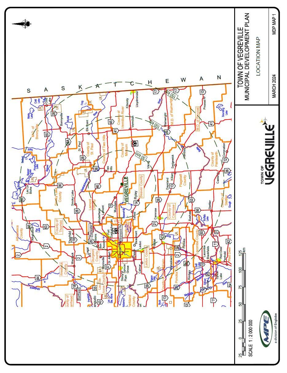
The Town of Vegreville is 100 km east of Edmonton, in the County of Minburn #27. Lying east of Elk Island National Park, with several lakes to the north and the Vermilion River running through it, Vegreville enjoys many natural features within and nearby
See Map 1: Location Map
2.0 HISTORIC GROWTH & URBAN FORM
Established in 1906 as a service center for the surrounding agricultural land uses, Vegreville has grown to become a community with a diversified economic base. Several large corporations and a Provincial research facility are located in Vegreville and have attracted highly skilled professionals and scientific researchers. The energy industry has positively impacted Vegreville’s economic growth, with a number of facilities located within the surrounding County of Minburn. Vegreville has remained true to its roots, with support of regional agricultural activity and agriculturally based industries key to the economy.
Vegreville residents experience a well-established high quality of life, supported by social, recreational, and commercial amenities that exceed those found in many similar size communities. Th e mix of land uses (residential, commercial, industrial, public) is diverse and varied. With such a diverse range of land uses in a small area, locating land uses to avoid potential conflict is of importance to the Town.
3.0 EXISTING LAND USES
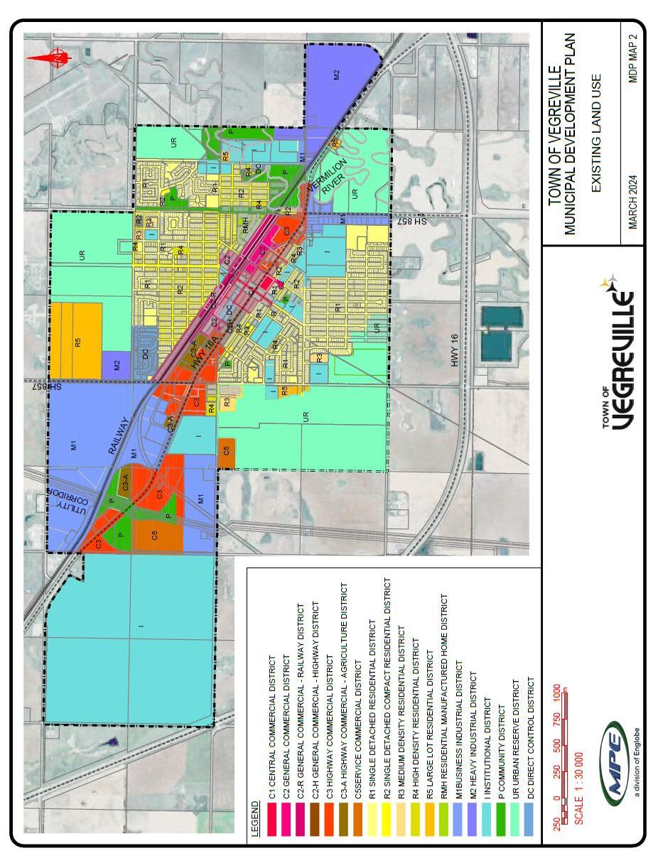
Land use is typical of many towns in Alberta, with growth radiating from the original railway and commercial core. Commercial land uses line the main arterial streets (50th Avenue and 50th Street) with residential development surrounding the original commercial areas. In the northwest area of the Town, a node of commercial development has been created adjacent to the research facility. Institutional land uses are located throughout the residential areas of the Town as are parkland and natural reserves.
– See Map 2: Existing
Industrial land uses are clustered together in the northwest and southeast areas of the Town, and in the railway corridor. A large tract of land is zoned as industrial to the northwest, where the Innotech Alberta campus is located. Industrial land uses are also located on the south-eastern entry to Vegreville
4.0 DEVELOPMENT CONSTRAINTS
4.1
TOPOGRAPHY
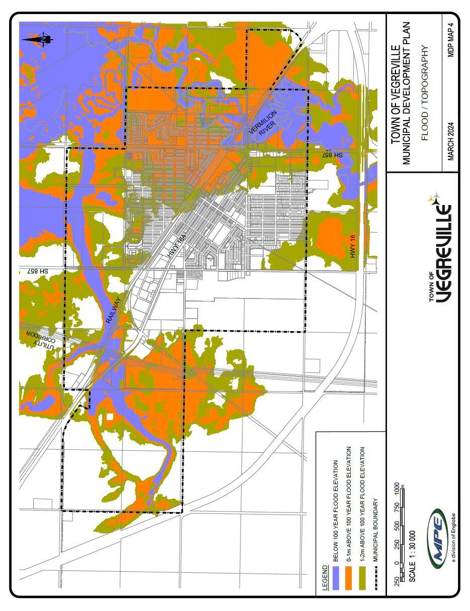
Land in and around Vegreville is relatively flat, with a general slope from the southwest down to the northeast. The general flatness of the area presents surface drainage constraints; however, construction of the North Drainage Way has addressed major storm water management issues. The Provincial Merged Wetland Inventory (available at GeoDiscover Alberta) shows wetlands associated with the water course through the North Drainage Way and with small sloughs in the south west corner of the town. The Vermilion River flows north through the east portion, through undeveloped land south of Highway 16A, and through park and residential land to the north. The Provincial Flood Study (available at Alberta Floods Portal) shows 45 ha of undeveloped land south of the highway affected by a 1:100 flood, with an additional 6ha north of the highway, predominantly in public ownership, also affected.
4.2 LAND USE CONFLICTS
4.2.1
AIRPORT
The airport, lying northeast of the Town, is buffered by the golf course from existing residential development one kilometre to its southwest Neither approach nor departure paths pass over the Town, however noise sensitive development closer to the site may be affected by air traffic. Planning must ensure that sensitive land uses are not established that could restrict airport use and future development.
4.2.2 HIGHWAYS AND RAILWAY
Provincial Highways 16A and 857 and the CN rail line through the Town provide excellent transportation connections that contribute to Prosperity; however, these corridors divide the community and present barriers to contiguous development. Noise and transportation of hazardous materials may limit potential nearby uses. The Provincial Highway Development and Protection Regulations and the Federation of Canadian Municipalities Guidelines for New Development in Proximity to Railway Operations (available at 2013_05_29_Guidelines_NewDevelopment_E.pdf (wpengine.com) provide relevant information to minimize conflict between development and these key transportation systems.
The Highway 16 bypass to the south poses a long-term restriction to growth in that direction. However, as the land between the existing urban boundary and Highway 16 is estimated to accommodate in excess of 15,000 people, it is not a limiting factor at this time. Similarly, while the realignment eastward of the south leg of Highway 857 and the relocation south westward of the Highway 16 east interchange will alter traffic patterns and may affect land uses on the current 857 route, these changes are not in the foreseeable future.
4.2.3 LANDFILL AND WASTEWATER LAGOONS
Subdivision and development of land for hospitals, schools, food establishments, and residences is restricted in the vicinity of landfills and wastewater facilities. The Town’s landfill and wastewater lagoons lie to the northeast, beyond the required setback distances for these facilities. These facilities have sufficient capacity (117 years landfill, 15,000 population wastewater) without expanding their sites. These facilities do not present restrictions to industrial or non-food commercial development.
4.2.4 PIPELINE S
Oil and gas pipelines are located in both developed and undeveloped areas of Vegreville. Interference with these facilities can have disastrous consequences. Relocating lines to accommodate development is costly, and usually beyond the value of the land that can be developed. Incorporating pipeline right of ways into park and open space corridors or parking and storage areas can protect the pipelines from damage while allowing use of the area.
5.0 LAND USE CONSUMPTION
POPULATION PROJECTIONS
Figure 1 illustrates the population for the Town of Vegreville from 2001 to 2021. This figure demonstrates a recent annual population loss of 0.09%, which contrasts to the growth rate since 1986 of 0.06%. Population growth fluctuates, principally following wider economic trends, however growth is expected to continue over the long term at an average rate of 0.4%. At that growth rate, 6500 people will call Vegreville home in 2045, twenty-two years from now.
In 2021, there were 2351 occupied dwelling units in the town, for an average household of 2.28 people. A 0.4% growth rate would initially require an additional 10 dwelling units per year, or about 300 over the next twenty-five years. The 2021 census indicated that there were 263 vacant dwelling units, indicating that significant population growth can be accommodated with minimal new construction. There is currently sufficient vacant developed land in Vegreville to support in excess of 4 years of residential development. Redevelopment and infill opportunities, coupled with greenfield development on land currently designated for residential development will support growth for over 20 years at the current mix of densities.
As a means of expanding and diversifying its economic base, the Town is proactive in attracting commercial and industrial development Commercial and industrial land requirements are very specific to their intended use, presenting difficulty in providing an inventory or projecting consumption A significant amount of vacant land is available for these uses, with initial planning in the form of Area Structure Plans in place.
6.0 CONSULTATION
In keeping with Council’s desire to ensure residents and stakeholders in Vegreville be kept abreast of planning policy changes, public consultation was held in the winter of 2024. Draft MDP Goals and Policies were available for online review, and an Open House, prior to the required Public Hearing.
7.0 GU IDING PRINCIPLES FOR LAND USE & FUTURE DEVELOPMENT
The Vegreville MDP review identified the following principles to guide plan development:
• The general direction of the Vegreville Municipal Development Plan is to have a land use plan that supports growth of the community.
• Growth will ensure social and financial stability to sustain and expand community amenities.
• Agriculturally based industrial and commercial development supported by the surrounding rural area will create new employment opportunities, resulting in retention of existing residents and attraction of new residents.
• To ensure industrial development can attract the required work force, people must find the community an attractive place to live. Housing affordability and supply, social strength, and community amenities are among the assets that affect Vegreville’s attractiveness to a prospective resident.
• Community amenities (recreational, cultural, social, transportation, utility, health, education) are sufficient to support growth, but require ongoing review to ensure they continue to do so.
• The current land base of the town is sufficient for growth without a need for annexation in the immediate future. Extension of municipal servicing is possible at the time annexation is anticipated and agreed to.
• Continued support of the business and social communities to ensure they remain healthy is important.
These principles are intended to maintain and enhance the high quality of life that the community expects. This MDP includes goals and policies based on these principles To incorporate these principles into the MDP, the following goals set the overall approach to municipal development planning in Vegreville.
7.1 GENERAL GOALS
Maintain and improve the quality of life;
Ensure growth and change respect social, economic and environmental community matters;
Ensure growth and change are economically and environmentally sustainable;
Continue transparent, collaborative communication among residents, stakeholders, developers and the Town;
Maintain and improve strong intermunicipal and interagency relationships.
The land use framework for Vegreville continues to support the historic and current pattern of growth with residential radiating out from the core (to the north and south), commercial in the centre and industrial uses at the outer edges. Redevelopment to move industrial and service commercial away from the Highway 16A corridor and into designated industrial areas and business parks will reduce industrial/non-industrial conflicts, and free up land for other (commercial) uses. There is opportunity to create a vibrant commercial core and highway corridor with a mixture of commercial uses, amenities, and higher density housing. New or expanding residential areas will also respect potential for increased density and a variety in forms of housing to meet demand, changing demographics and affordability factors. Besides continued redevelopment opportunities, the Town has designated major land areas for new residential neighbourhoods that will accommodate different standards of housing, development aesthetics and integration with green space. All in all, the pattern of growth and development will respect efficiencies but support a mixture of land uses as the population increases and the tax base is diversified.
7.1.1 GENERAL GOALS
Identify land for future industrial, commercial, and residential uses;
Address development constraints;
Optimize investment in infrastructure;
Integrate green space and open spaces into development;
Identify future growth opportunities to ensure a supply of developable land is available
7.1.2 GENERAL POLICIES
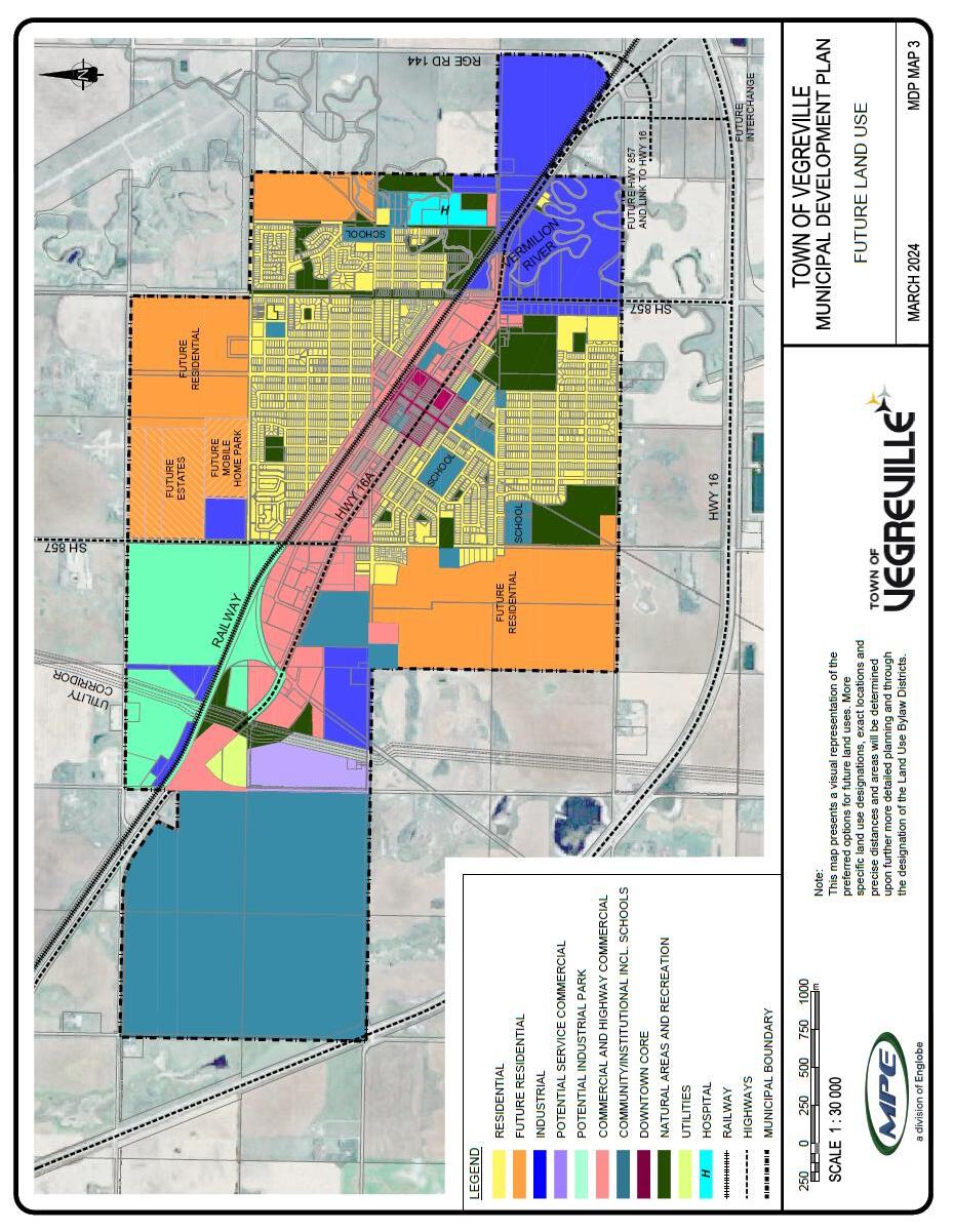
7.1.2 (A) Future development in Vegreville shall be in general conformance with Map 3: Future Land Uses. Map 3 will be used as a guide when assessing future development proposals.
7.1.2 (B) Development and subdivision proposals that are contrary to the goals and policies of this plan will be assessed and evaluated based on their merits.
7.1.2 (C ) Priority shall be given to development that infills existing serviced areas followed by areas where infrastructure can be economically extended provided due regard is given to the following:
• Compatibility with surrounding land uses;
• Continuity with nearby streetscape and allotment patterns;
• Compatibility in height, scale and design of other buildings in the vicinity;
• Appropriate landscaping, provision of parking/loading, and preservation of existing vegetation;
• Preservation and integration of buildings considered to have historical and/or architectural significance;
• Infrastructure capacity;
• Encouragement of additional low density infill units through semidetached or two or more singledetached units replacing a single detached unit
7.1.2 (D) The Town shall require Area Structure Plans to be prepared by developers for consideration by Council for new developments and subdivisions. Area Structure Plans shall be supported by report addressing:
• Site conditions and topography;
• Proposed and existing Land Uses, and mitigation of conflicts;
• Population and density;
• Transportation, servicing infrastructure, and capacities;
• Protection of locally significant natural areas and archaeologically or historically sensitive areas;
• Parks, open space, pedestrian walkway systems, school sites and school population;
• compliance with the MDP;
• Other topics deemed appropriate by the Town.
7.1.2 (E) The Town will work collaboratively with private sector interests to develop the Town in accordance with the Future Land Use Map (Map 3)
7.1.2 (F) Upon the subdivision of land, the Town will require the provision of reserves; in the form of land, money, or a combination thereof; to the maximum amount provided for in the Municipal Government Act.
7. 1.21 ( G) New development and redevelopment will be required to provide all on-site and off-site servicing required by the subject development.
7.1.2 (H) The Town shall encourage early consultation with the public, developers, and stakeholder groups to ensure efficient and effective development review processes occur.
7.2 EN VIRONMENTAL MANAGEMENT
The community places a significant priority on protecting the integrity of the natural environment. It is recognized that the natural resources of the area will have long term benefit to the residents, visitors, wildlife, and general ecosystem for current and future generations to enjoy. Natural water ways and associated areas subject to flooding are prominent in and around Vegreville. Appropriate study, management, planning and development around these features will help ensure a sustainable, healthy, and aesthetically pleasing environment as the community grows.
7.2. 1 ENVIRONMENTAL GOALS
Development will not have negative impacts on the natural environment.
The health of the natural environment, both within and surrounding the built environment, will be maintained;
Environmental resources will be protected for the long-term benefit of wildlife, natural ecosystems and the enjoyment of the present and future population and visitors to Vegreville;
Areas susceptible to flooding and land erosion will remain in their natural state.
7.2. 2 ENVIRONMENTAL POLICIES
7.2. 2 (A) The Town shall protect natural and environmentally sensitive areas. Environmental assessments shall be prepared for any proposed development that may have negative effects on a natural area or environmental resource. An environmental assessment shall include, but not be limited to:
• A description of the proposed development;
• A description of the environmental values that would be affected;
• An assessment of the environmental effects (both positive and negative) that the development may have on the natural area;
• Recommendations to mitigate and minimize any negative effects identified; and
• An assessment of the long-term effects that may impact the sustainability of the natural area.
7.2. 2 ( B) The Town will support developments that actively seek to reduce and mitigate their environmental impact.
7.2. 2 (C) The Town will control development in areas prone to flooding, as shown on Map 4: Flood Hazard, which illustrates the Flood Hazard Area
7.2. 2 (D) No permanent residential developments or institutional land uses such as hospitals, age care homes, schools, or commercial and industrial land uses with associated hazard, chemical or toxic materials handling, processing or wastes, shall be allowed in the Flood Hazard Area
7.2. 2 (E) The Town will consider permitting such uses as the following in the Flood Hazard Area; private open space, environmental reserve, natural areas, parks, bridge support structures and related roadways.
7.2. 2 (F) The Town will consider removal of property from the Flood Hazard Area, allowing for controlled development, if the property is filled and protected from flooding in accordance with requirements of the province.
7.2.2 (G) At the time of subdivision, the Town will use environmental reserve and environmental conservation easements to protect environmentally significant areas and land environmentally unsuitable for development to maximize the open space available to the community during the subdivision process.
7.2 .2 (H) Lands dedicated as environmental reserve or environmental conservation easements shall remain in their natural state, however such things as public trails, public parks, public facilities, and any works necessary to ensure public safety may be developed.
7.2. 2 (I) Tree conservation and the preservation of significant mature vegetation and replanting shall be a consideration in their view o f Area Structure Plans and Area Redevelopment Plans, rezonings, subdivisions and development permit applications. Vegetation assessment surveys may be required to support the Town in making decisions on developments at the cost of the developer.
7.3 RE SIDENTIAL
Residential Areas are and the quality of development are often the most distinguishing characteristics of a community. Vegreville continues to enrich that quality of neighbourhood by respecting the integrity of mature areas and encouraging proper infill that complements existing development. Although Vegreville has a predominantly single-family housing stock, the demand for various other forms of housing will continue to grow. Residents have suggested that new housing forms such as town houses, apartments/condos, manufactured homes, and mixed-use developments should be provided, but attractively designed and strategically located adjacent to services and amenities. Private development interests will continue to be encouraged to consider the possibilities of creating quality living environments in Vegreville. They should also respect the evolving consumer demand for both increased quality of product at one extreme and affordability at the other extreme. Both can be incorporated into the future residential areas.
7.3. 1 RESIDENTIAL GOALS
To have a range of housing opportunities, styles and options;
To have a high standard of design, safety and amenity in areas;
To have land developed by the private and public sectors;
To complete the development on existing serviceable lands prior to undertaking new subdivisions;
To have infill development that complements existing development revitalize older neighborhoods;
To ensure the integrity of mature neighbourhoods is recognized by infill development;
To retain heritage homes.
7.3. 2 RESIDENTIAL POLICIES
7.3. 2 (A) Existing and future residential uses are and will be located within the residential land use areas mapped in Map 3: Future Land Uses
7.3. 2 (B) Development will be planned such that existing municipal infrastructure is utilized to the most efficient extent possible.
7.3. 2 (C) The Town supports infill development and the restoration of existing homes as an alternative to the development of new residential areas.
7.3. 2 (D) The Town supports infill housing on vacant or underutilized sites provided:
• The proposed infill development is compatible with adjacent properties;
• Infrastructure capacity is not compromised; and
• The development is in keeping with the height, mass, scale, and appearance of the surrounding dwellings
7.3 .2 (E) The Town supports the development of mix ed density neighborhoods. Mixed density neighbourhoods include multiple unit dwellings and higher density developments located in areas accessible to arterial or collector roads, where traffic generated by the development will not affect the use of roads in the area, access to schools and community facilities, and where the appearance and amenity of an existing residential neighbourhood will not be adversely affected.
7.3. 2 (F) The Town supports the development of manufactured home communities within areas identified on Map 3: Future Land Use. Future new manufactured home communities will be developed on a pre-planned basis on individual titled parcels.
7.3. 2 (G) The Town supports the development of estate style homes within areas identified on Map 3: Future Land Use. Future estates style homes will consist of homes located on parcels of 0.5 to 2.0 acres in size.
7.3. 2 (H) New developments, including manufacture home communities, shall have paved streets, curbs, gutters, and sidewalks on both sides of the street, and provide underground services with rear lanes. Within estate residential subdivisions, no sidewalks will be required; however, developers will be encouraged to develop trail systems.
7.3. 2 (I) In situations where it is not possible to separate residential development from incompatible uses, a landscaped buffer, berm, or hard screening will be required.
7.3. 2 (J) The Town shall continue to encourage the private sector to develop land in Vegreville.
7.3. 2 (K) The Town supports the provision of linear green spaces which may be developed as trails to act as linkages between residential areas, schools, open spaces, and community facilities.
7.3. 2 (L) The Town shall regularly monitor changing housing needs and the Town’s progress in addressing housing demand.
7.3. 2 (M) Th e Town shall promote community awareness of the importance of heritage home conservation and encourage retention and restoration of such homes where feasible.
7.4 CO MMERCIAL
Commercial uses in Vegreville were historically located in the downtown core, which has been the focal point and civic centre or heart of the community. Over the years, commercial development spread along Highway 16A and took on various forms including retail, service, and highway commercial activity. Much of the office and community services are located in the downtown core, providing a civic presence.
Commercial development in Vegreville has evolved to also include large format retail stores and associated outlets that are vehicle oriented with direct access to major roadways. The growth of surrounding communities continues to support Vegreville as a regional service centre. Though the pressures to develop more commercial lands will prevail as the demand for commercial goods and services rises with population growth, Vegreville should not lose sight of retaining its core.
7.4.1 COMMERCIAL GOALS
To have land available for a full range of commercial goods and services;
To maintain the Town centre as the commercial heart of Vegreville;
To have commercial uses not conflict with non-commercial uses;
To have aesthetically pleasing commercial development;
To recognize and promote the benefits of growth and prosperity of the business community in the economic sustainability of Vegreville.
7.4.2 COMMERCIAL POLICIES
7. 4.2 (A) Future development in Vegreville shall be in general conformance with Map 3: Future Land Uses. Map 3 will be used as a guide when assessing future development proposals.
7. 4.2 ( B) The Town will encourage commercial land uses to be located in the following designated areas:
• The Downtown Core;
• Highway Commercial Area;
• Service Commercial Area (includes Business Park); and
• Future Neighbourhood Commercial Area (by District)
7. 4.2 (C) The To wn recognizes strategically located vacant land that could be zoned and serviced for commercial development. The Town will work with individual landowners and support ongoing availability of land for commercial development.
7. 4.2 (D) All large format retail store development proposals shall be subject to design guidelines, traffic impact studies, and a social and economic impact evaluation.
7. 4.2 (E) The Town supports arterial and highway commercial development along Highways 16A and 857 within the Town boundaries as illustrated on Map 3: Future Land Uses
7. 4.2 (F ) The Town will work closely with Alberta Transportation and Economic Corridors to ensure safe and efficient access and egress for commercial developments along Highways 16, 16A and 857.
7. 4.2 (G) The Town encourages mixed use commercial and residential development within the CBD and Neighbourhood Commercial areas Buildings can accommodate a mixture of retail, service, or office space at the ground level, with residential uses located above.
7. 4.2 (H) Home occupations will be allowed in all residential areas. Specific development standards or requirements will be governed by the Land Use Bylaw Home based businesses must be compatible with the scale and character of the residential neighbourhoods within which they are being proposed.
7.5 I NDUSTRIAL
Vegreville’s industrial development and associated businesses support a prosperous local economy. In order to maintain a diverse and sustainable economy, Vegreville will continue to encourage a broad range of industrial uses.
The Town will ensure that properly designated lands are made available within the municipal boundary so that the community can benefit from employment opportunities and continue to build its non-residential tax base. The Town is aware of the negative impacts that may be associated with industrial activity. Potential conflicts between industrial and non-industrial land uses will be minimized by creating appropriate locations where existing industry can relocate or where new industrial activity can be directed.
The Town will encourage industry that may require outdoor storage, processing, or manufacturing, to locate away from the Highway. New industrial development will be subject to design control and environmental impact assessments to help respect the environmental and social integrity of the community.
Vegreville hosts the Innotech Alberta campus with a significant employment base and vacant lands that can accommodat e related development. Currently zoned for industrial use, these lands are set aside for clean industry
and research facilities that will complement the objectives of the Innotech Alberta to further its cause in building a sustainable economy for the Province of Alberta.
7.5.1 INDUSTRIAL GOALS
To accommodate a broad range of industrial uses in keeping with the need to maintain a diverse and sustainable local economy.
To minimize potential conflicts between industrial and non-industrial land uses.
To respect the environmental and social integrity of the community by supporting industrial site locations that do not detract from community health, natural ecosystems, and the overall quality lifestyle of the residents.
To provide infrastructure that will help attract and maintain industrial development;
To have land available for industrial development.
7.5.2 INDUSTRIAL POLICIES
7. 5.2 (A) Future development in Vegreville shall be in general conformance with Map 3: Future Land Uses. Map 3 will be used as a guide when assessing future development proposals.
7. 5.2 ( B) The Town will encourage industrial land uses to be located in the following designated areas:
• General Industrial
• Light Industrial/Service Commercial.
7. 5.2 (C) General Industrial refers to areas that will accommodate a mixture of industrial activity including heavy industry that may be associated with more capital-intensive operations, emissions of wastes and involve processing of materials. The intent is to ensure that general industrial areas are well buffered by distance and located strategically away from non -compatible uses such as residential. Any outdoor activity that involves extensive storage, unsightly premises or outdoor assembly may be associated with a heavy industrial area. Retail activity is usually not associated with general industry and would only be permitted subject to zoning.
7. 5.2 (D) Light Industrial/Service Commercial refers to less intensive industrial activity than heavy industrial. Light industry is often more consumer oriented than business-oriented (i.e. products are produced for end users rather than as intermediates for use by other industries). Light industry typically causes relatively little pollution, particularly compared to heavy industry. Some of the uses, often referred to as “service commercial” are primarily of a non-retail character and may involve outdoor storage or activity areas. Retail and office uses are allowed to the extent that they are compatible with service commercial uses. Examples of uses include small scale light assembly operations, motor vehicle repair and body shops, equipment rental, small-scale warehousing, and distribution, and “workshop” type commercial land uses (e.g., welding and cabinet/carpentry shops).
7. 5.2 ( E) The Town will support the initiatives of Vegreville Economic Development to promote the availability of land in Vegreville for industrial site selection to prospective users.
7. 5.2 ( F) Industrial development shall be sited to avoid conflict with noncompatible uses. Any lands subject to flooding or hazard such as slumping or other geotechnical concerns shall be avoided for industrial development unless proper studies are conducted, and results confirm site suitability for both the use and the continued environmental integrity of the land.
7. 5.2 ( G) Heavy industrial uses that involve processing, manufacturing, create any emissions, or health concerns, shall be subject to an environmental impact assessment.
7. 5.2 ( H) The Town supports the relocation of existing unsightly industrial uses away from Highway 16A.
7. 5.2 (I) Industrial uses that require extensive outdoor storage/laydown yards, wrecking yards or processing and manufacturing shall be directed to locations or industrial parks that are not directly visible from major entryways into the community, and where design guidelines and screening of any unsightly premises can address potential inherent operating issues.
7. 5.2 ( J) The disposal of any industrial wastes, recycling and/or containment of hazardous wastes shall be conducted within strict management standards, and/or in sanctioned regional recycling and waste management facilities.
7. 5.2 ( K) The Town will work with the County of Minburn to address planning and development issues and opportunities related to the Airport lands, and rail and truck routes that may benefit industrial development in and around Vegreville. These issues and opportunities may include available land, industrial site location requirements, access, complementary siting with other businesses and provision of services.
7.6 R ECREATION, CULTURE, PARKS , INSTITUTIONS & OPEN SPACES
Attractive parks, open space and recreation facilities contribute to the quality of life in Vegreville. The Town recognizes that enhancement and continued additions to these facilities will continue to make Vegreville attractive to residents and visitors alike, but also foster a healthy, active, and involved community.
Residents have confirmed the need to integrate parks and open spaces by protecting existing natural areas and locating them within easy access to residential neighbourhoods, especially for pedestrians and cyclists. Vegreville prides itself in its trail system that links parks and recreational facilities with residential areas. The Town has committed to continue to expand this trail network along with the open space system.
The vision for Vegreville is to complete a connected system that can be used by all age groups and during all seasons of the year. By maintaining this commitment and vision, Vegreville will continue to entice visitors, new business and investment, and residents seeking a socially supported community.
School sites provide a significant amount of open space in the community and are important to its social and recreational needs. Consideration to the provision of additional lands for schools benefits the school boards and the community at large.
7.6.1 RECREATION, CULTURE , PARKS, INSTITUTIONS , & OPEN SPACE GOALS
To protect and preserve existing natural areas;
To have open spaces that are functional and effective in satisfying the recreation, culture and social needs of residents and visitors to Vegreville;
To ensure that the design and location of recreation facilities, parks, trails and open spaces are to a high standard and fitting of their surroundings;
To have a safe environment for pedestrians and cyclists in Vegreville;
To have a healthy, active and involved community environment, which sustains community well-being through leisure and recreation services and facilities;
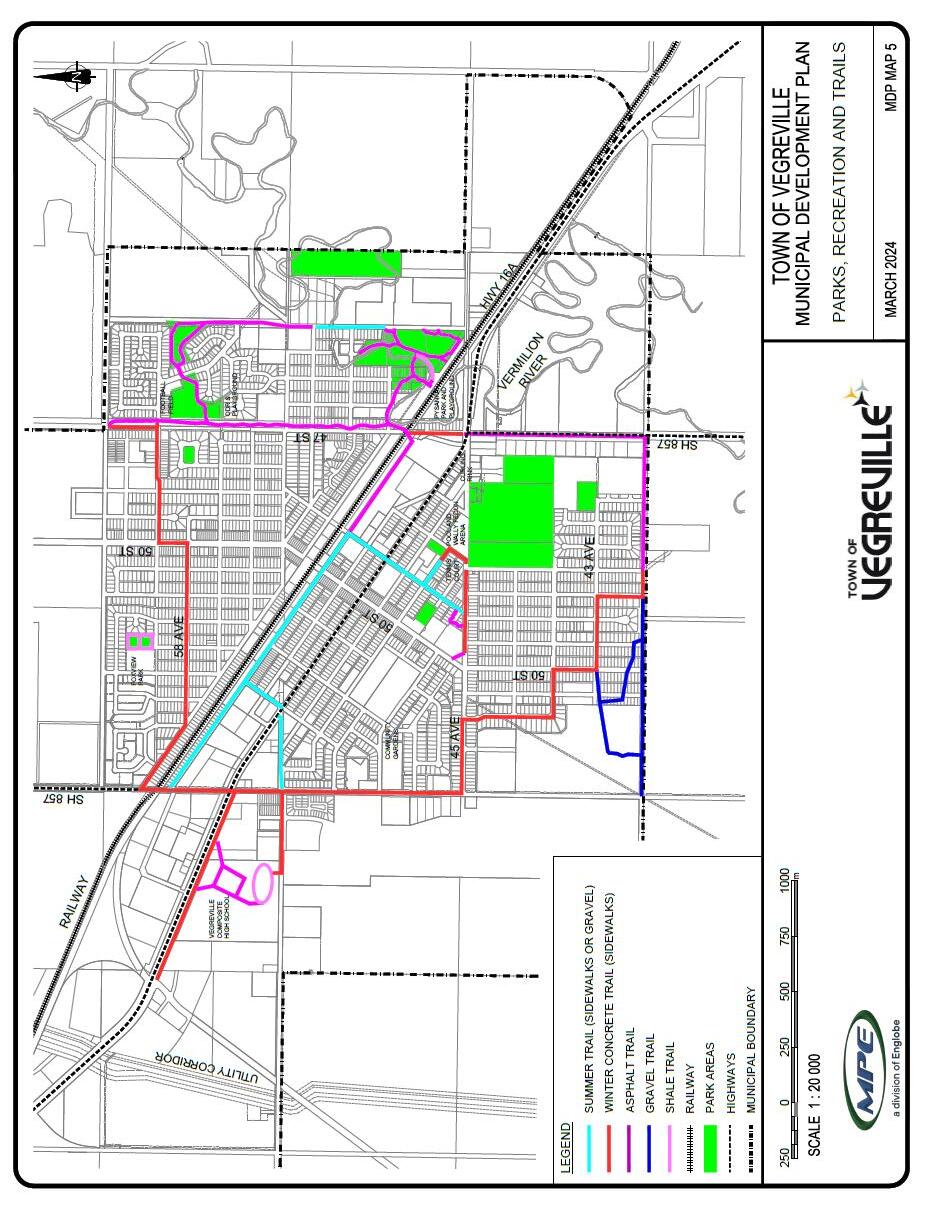
Map 5: Parks, Recreations and Trails
7.6.2 RECREATION, CULTURE , PARKS, INSTITUTIONS , & OPEN SPACE POLICIES
7. 6 .2 ( A )The Town will encourage the use of theatres, spaces and venues for public participation, education and enjoyment of culture and recreation through the planning and design of buildings, open spaces, and public areas, including the street environment.
7. 6 .2 (B) The Town will ensure that land provided for parks and open space is located to allow easy access from residential areas. Maximizing pedestrian access and connectivity should be achieved.
7. 6 .2 (C) The Town will ensure residential Area Structure Plans address future needs for school sites
7. 6 .2 (D) Redevelopment of surplus school sites for uses compatible with the neighborhood will be accommodated by the Town, with an emphasis on provision of open space.
7. 6 .2 ( E) Connections of sidewalks to trails will be provided for an uninterrupted and integrated pedestrian network.
7. 6 .2 ( F ) Consideration will be given to a tree planting program using native plant species to maximize landscape survival rates and minimize maintenance in all public areas of the community
7. 6 .2 ( G ) The Town supports the Integration of natural stormwater management systems into parks and open spaces
7. 6 .2 ( H) The Town supports organizations and groups use of public spaces for community events.
7. 6 .2 ( I ) Industrial and Commercial subdivisions may provide cash in lieu of land for Municipal Reserves at the time of subdivision unless the land is required for a buffer, trail corridor, or access to an Environmental Reserve.
7.7 TR ANSPORTATION
Vegreville’s transportation system serves an important function in the evolution of the Town’s development pattern, urban infrastructure, and local economy. Highway 16, 16A and 857 connect Vegreville to other important centres such as Edmonton to the west, and Lloydminster to the east. They also provide direct and convenient access into industrial areas and businesses along the highway commercial stretch of Vegreville. The commercial enterprises benefit from exposure to the travelling public along Highway 16A, but more importantly, these roadways provide efficient movement of goods, services, and people through and to Vegreville. Highway development regulations require Alberta Transportation and Economic Corridors approval of development within 800m of the highways, and subdivisions within 1600m. This area encompasses most of the Town. A cooperative position with the Provincial Authority can reduce conflicts in planning issues in the affected area.
The Vegreville transportation system also includes the CN Railway that largely parallels Highway 16A through town. There are two important railway crossings close to the downtown core, otherwise the other links between the south part and north part of the community are at the east end and west end, 43 Street and Highway 857, respectively. The noise and potential for hazardous materials on the railway affect the potential adjacent uses, primarily residential, and must be considered in subdivision and development reviews.
In keeping with the Town’s vision for creating quality residential neighbourhoods and public areas, all future roads serving residential and commercial areas will be paved, with curbs and gutters, and incorporated into the sidewalk or trail system where appropriate.
Lastly, the Vegreville Regional Airport is located just outside of the town boundary. For a small town, this is an excellent additional transportation link for inbound and outbound passengers and goods. It is a registered airport with a 1,219-meter runway and a modern terminal. Should this facility be annexed into Vegreville, industrial/commercial lands in the vicinity of the airport may be serviced with municipal utilities and further warrant enhancement of the airport and related infrastructure.
7.7.1 TRANSPORTATION GOALS
Provide for the safe and efficient movement of goods and people within and through Vegreville.
To provide adequate transportation infrastructure and services in a timely manner to create connectivity and promote pleasant, safe pedestrian travel and other forms of alternative transportation methods as a primary means of movement and an important quality of life attribute.
To identify short and long-term transportation needs of both the Town and the surrounding region and strive to ensure that these needs are adequately met in a manner that is compatible with existing and future development.
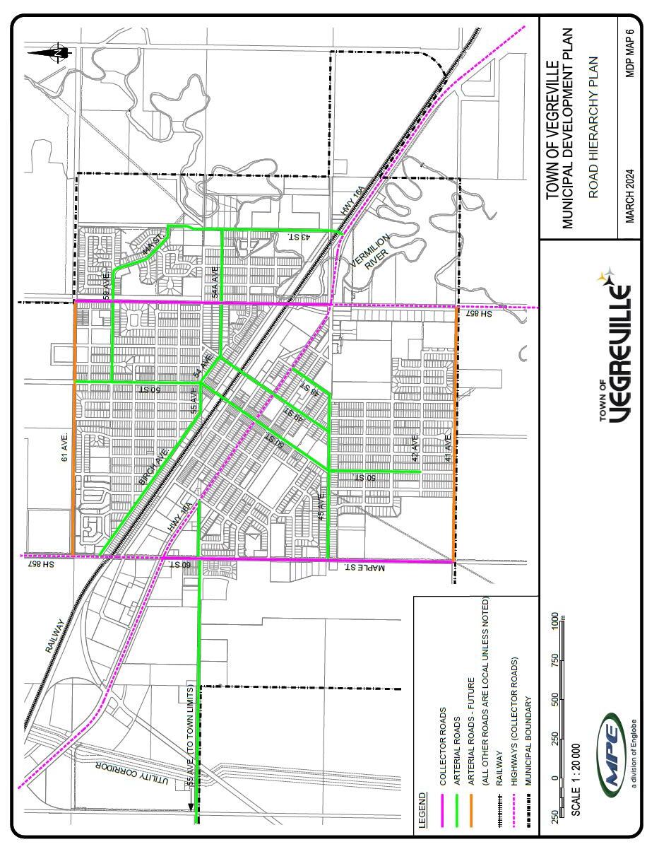
See Map 6: Road Hierarchy Plan
7.7.2 TRANSPORTATION POLICIES
7.7.2(A) The Town will protect Highways 16, 16A, and 857 by coordinating with Alberta Transportation and Economic Corridors to require new development to be planned in a manner that promotes the flow and safety of traffic.
7.7.2(B) The Town will use the City of Edmonton’s traffic engineering standards and specifications, as a minimum, for the future development of roads. These shall include the width of future roads, required right-of-way, methods of construction, placement of signage, and sidewalks, lighting, landscaping requirements and intersection treatments.
7.7.2(C) All roads servicing new residential and commercial development shall be paved with concrete curbs and gutters. Dependant on location and connectivity to the existing network of sidewalks and trails the Town may request sidewalks and trails be incorporated into the design of new developments or redevelopments.
7.7.2(D) The Town shall ensure that pipeline easements or rights of way in a proposed subdivision shall only be accepted as Municipal Reserve if it can be shown that the easements or rights of way will form part of a trail system which is integral to the development
7.7.2(E) In granting a subdivision approval or development permit, the Town may require that the developer pay for all or part of the cost of any public roadway or pedestrian/bicycle trail system, in excess of the minimum requirements. Where such additional improvements are required, the Town will negotiate a cost sharing agreement associated with the extra improvements.
7.7.2(F) The To wn may require a traffic impact assessment for redesignations, subdivision, and development permit applications. In addition, Area Structure Plans should address the following transportation factors:
• The staging of the development in respect of the road network;
• Land uses in the vicinity of Highway 16A, Highway 16 and arterial roadways;
• Truck routes and dangerous goods routes;
• Energy conservation measures;
• The provision for safe roadway access;
• Safe and convenient roadway crossings for pedestrians and bicycles; and
• Noise attenuation requirements.
7.7.2(G) The Town shall minimize the adverse impacts of heavy vehicle traffic movements by:
• Designating specified truck and hazardous goods routes;
• Discouragement of heavy vehicle movements on collector and local roads through residential areas;
• Restrict land uses that may generate high traffic volumes of heavy vehicles to industrial and highway commercial areas.
7.7.2(H) The Town will work collaboratively with Alberta Transportation and Economic Corridors during the planning, design and construction phases of the Highway 857 realignment and interchange improvements at the Highway 16/16A intersection.
7.7.2(I) The Town will work with Alberta Transportation and Economic Corridors on traffic control methods, and median landscaping to beautify and increase safety on Highway 16A.
7.7.2(J) The Town shall encourage alternative forms of transportation including cycling and pedestrian movements as well as mixed use developments, so residents can live, work and shop without depending on private vehicles.
7.7.2(K) The Town shall support initiatives and programs to provide mobility transit services to elderly residents and people with disabilities.
7.8 U TILITIES AND INFRASTRUCTURE
7.8.1 UTILITY AND INFRASTRUCTURE GOALS
To provide municipal utilities that safely, effectively, economically, and efficiently meet the current and future needs of the Town.
To provide access to high quality infrastructure services for all community residents through a prioritized and financially viable infrastructure delivery plan.
To ensure that the developers are responsible for any costs arising from the provision or necessary upgrading of utility lines and associated facilities to service a development area. This includes, but is not limited to, the installation of major water, sanitary and storm sewer trunks.
To ensure that public utility operators are informed of future urban development in order to coordinate the extension of public utilities.
7.8.2 UTILITY AND INFRASTRUCTURE GOALS POLICIES
7.8.2 (A) In order to maximize the efficiency of existing infrastructure, infill development will be encouraged before the extension of services to new areas.
7.8.2 (B) New development shall be required to be serviced by all municipal utilities to a standard satisfactory to the Town at the expense of the developer (unless otherwise permitted by Town Council), subject to entering into a development agreement.
7.8.2 (C) Developments outside of the Town boundaries requiring municipal utilities from the Town shall not be serviced until arrangements for annexation of the area are completed.
7.8.2 (D) The Town shall avoid the use of infrastructure, in particular, as the primary catalyst or deterrent for development (servicing shall not solely dictate development potential).
7.8.2 (E) Prior to subdivision registration, the developer shall be required to provide detailed engineering plans for water, sanitary, and storm water servicing.
7.8.2 (F) Utility rights-or-way and public utility lots shall be provided at the time of subdivision.
7.8.2 (G) Storm water conveyance must be designed to accommodate a 1:100-year storm and not adversely affect traffic. Should the road right-of-way not be able to accommodate the 1:100 storm, on-site storm water ponds will be required. Storm water storage or retention is not allowed within roads.
7.8.2 (H) The Town shall continue to support waste reduction, redirection, recycling, and composting initiatives to reduce solid waste disposal
7.8.2 (I) In managing the Town’s water supply, a long term and sustainable approach to municipal supply shall be taken. Water supply will be prioritized to developments that align with the Future Land Use Map (Map 3) and the Town’s infrastructure delivery program.
7.8.2 (J) The Town shall consult with franchise utility providers on proposed development requiring services and provide for their utilities within Public Utility Lots, road, or utility right of ways.
7.9 C OMMUNITY WELLBEING
7.9.1 COMMUNITY WELLBEING GOALS
Enhance and maintain the physical, mental, and social well-being of community members.
Enhance the social infrastructure of Vegreville through improvements to the social support networks, education, employment/working conditions, social environments, physical environments, personal health practices and coping skills, healthy child development, health services, and culture.
It is the goal of the community of Vegreville to sustain its unique cultural identity by honoring and supporting the history, celebrating the community diversity, and promoting a dynamic cultural community.
Recognize the history and cultural identity of the Town by preserving cultural and heritage resources
7.9.2 COMMUNITY WELLBEING POLICIES
7.9.2(A) Develop and maintain a communications strategy to enhance the delivery of information between the Town, community, and user groups.
7.9.2(B) Work with the community to determine current and future health service needs in the community, particularly with respect to senior citizen services.
7.9.2(C) Support the provision of sound primary healthcare services for the whole community and promoting a positive and healthy lifestyle.
7.9.2(D) Provide a favorable living environment by implementing “barrier-free” designs in public places.
7.9.2(E) Provide a welcoming and supportive environment to all residents and visitors respecting diversities of cultures, demographics, values, and beliefs.
7.9.2(F) Maintain public safety by supporting police, fire protection, rescue and emergency and medical services.
7.9.2(G) The To wn will support activities that will provide opportunities for citizens to contribute positively to the community through volunteering, the provision of leadership development and support, and the empowerment of community members to identify needs, set priorities and pursue a common vision.
7.10 I NTER AGENCY PLANNING
7.10.1
INTERAGENCY PLANNING GOALS
To undertake cooperative and mutually beneficial planning with the County of Minburn, other municipalities in the region, and other organizations.
To have coordinated land use policies for the boundary areas which are mutually beneficial to both the Town and the County of Minburn.
7.10.2 INTERAGENCY PLANNING POLICIES
7.10.2 (A) The Town will endeavour to work with the County of Minburn and other municipalities in the region to address issues of mutual concern and to ensure that development complements the existing and future land uses of the other municipality.
7.10.2 (B) The Town in conjunction with the County of Minburn shall maintain the Intermunicipal Development Plan.
7.10.2 (C) The Town will discourage development or uses that may have a negative impact on adjacent uses in the County of Minburn.
7.10.2 (D) The Town will consult with the County of Minburn with regard to urban expansion and annexation.
7.10.2 (E) To accommodate long term growth, the Town ultimately intends to expand through annexation to the following areas:
• South to Highway 16 to accommodate mixed density residential neighbourhoods and mixed business subdivisions;
• East to accommodate industrial uses; and
• East and north to accommodate institutional uses.
7.10.2 (F) Developments within the County requiring municipal utilities from the Town shall not be serviced until arrangements for annexation of the area are completed.
7.10 .2 (G) The Town will work with Alberta Transportation and Economic Corridors and Utilities to address issues of mutual concern
7.10.2 (H) The Town will work with school districts to ensure sufficient land for school sites to accommodate growth is available.
7.10.2 (I) The Town will work with the John S. Batiuk Regional Water Commission to ensure sufficient capacity for growth is available.
8.0 A DMINISTRATIVE MATTERS
8.1
INTERPRETATION
• The Town shall take responsibility for a sustainable, positive community future by ensuring the ongoing health of the natural environment, both within and surrounding the built environment.
• The MDP is, for the most part, general in nature and long range in its outlook. The MDP provides the means whereby Council and Town staff can evaluate immediate situations or proposals in the context of a longrange plan for Vegreville. In this regard, the boundary between the land uses shown on Map 3: Future Land Uses presents a visual representation of the preferred options for future land uses. More specific land use designations, exact locations and precise distances and areas will be determined upon furthermore detailed planning and through the designation of the Land Use Bylaw Districts.
• Subject to Council’s approval, minor variations from the policies of the MDP will not require an amendment to the MDP. More substantive changes will require an amendment to the MDP and any other affected plan. Amendments that are required should be done so through a transparent public consultation process.
• The MDP contains “shall”, “will”, “should”, and “may” policies which are interpreted as follows:
“Shall and will” mean mandatory compliance.
“Should” means compliance in principle but is subject to the discretion of the Approving Authority where compliance is impracticable or undesirable because of valid planning principles or circumstance unique to a specific application.
“May” means that policies indicate that the Approving Authority determines the level of discretionary compliance that is applied.
• To get a complete understanding of this Municipal Development Plan, it is recommended that the reader review the entire document and not read specific sections or policies in isolation of the balance of the document.
• The Town may undertake the several further studies and preparation of design guidelines to supplement the MDP. 9.0 Implementation
9.0 IMPLEMENTATION
In support of the policy direction provided in this Municipal Development Plan (MDP), this section commits to an understanding of the need for the Town to implement various initiatives to help achieve their vision and goals. Some of these initiatives will be on -going throughout the life of the Plan, while others may be seen as critical steps to undertake soon after adoption and that will in turn allow other important objectives to be achieved.
9.1 INITIATIVES
9.1.1 AREA STRUCTURE PLANS/AREA PLANS
Area Structure Plans, Area Plans or Outline Plans will be a requirement of any new major development in Vegreville. The Town may prepare or approve specific terms of reference for each plan before allowing any private development to proceed.
9.1.2 CONSULTATION WITH KEY COMMUNITY GROUPS
The Town will endeavor to provide opportunities to become aware of municipal initiatives and for community stakeholder groups and interested citizens to have input on important social, economic, and environmental issues. These opportunities will come in the form of public meetings, special meetings on key topics, surveys and through the use of the Town’s website
9.1.3 INTER - MUNICIPAL COLLABORATION
Integral to the implementation of the policies in this MDP and especially those policies that relate to the fringe area or any common interest to both Town and County will require close collaboration with the County of Minburn. Implementation will include scheduled meeting dates, issue resolution and planning initiatives such as the Intermunicipal Development Plan to help identify common ground and joint approaches between the two agencies.
9.1.4 SUPPORT OF SOCIETIES AND CULTURAL ORGANIZATIONS
The Town will identify key societies and cultural organizations and maintain open communication with them. The Town will endeavor to understand the goals and objectives of these agencies in keeping with the vision of building a strong sustainable community for Vegreville.
9.1.5
STUDIES
The Town may call for or conduct studies of various nature to assist them in making astute land management or development decisions from time to time.
9.1.6
ANNEX ATION
The Town owned lands outside of the municipal boundary have potential for various uses. The future uses of these properties will be identified in the Intermunicipal Development Plan, with the timing of annexation subject to the agreement of the municipal Councils.