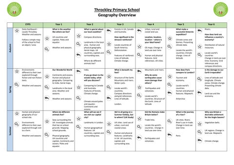
Throckley Primary School Geography Overview EYFS
Autumn
Daily Dashboard Locate Throckley Weather and seasons Follow a simple map of the school to find an object / area
Year 1 What is the weather like where we live? UK countries and capitals. Poles and equator. Weather and seasons.
Year 2 What is special about our local coastline? Compass directions. Landmarks in the local area. Human and physical geography. Aerial maps. UK countries, capitals and surrounding seas. Where do different animals live?
Spring
Environments different to their own explored through fiction and non-fiction texts.
Our Wonderful World
India.
Continents and oceans. Human and physical geography. Comparing to India. Aerial maps.
If you go down to the woods today, what will you discover?
Weather and seasons Landmarks in the local area. Weather and seasons.
Comparing to Canada and Australia. Features of forests. Climate change.
Weather and seasons.
Summer
Human and physical geography of our school site. Environments different to their own explored through visit to a farm. Weather and seasons
Where do different animals live? Seas surrounding the UK. Investigate animals that live on school grounds. Mapping school grounds. Physical geography. UK countries and capitals. Continents and oceans. Poles and equator.
Climate around poles and equator. Continents and oceans. What will we see if we visit our capital city? Landmarks in London. Human geographical features. UK countries, capitals and surrounding seas.
Year 3 Forests in UK, Canada and Australia. How significant is the Amazon rainforest?
Year 4 Urban, rural and costal land use. Location, location, location – where is your ideal home?
Locate countries of South America. Deforestation.
OS maps. Change in land use over time
Features of rainforest. Lines of latitude. Climate change.
Human and physical features. Grid references. UK cities.
What is beneath my feet?
Mountains and rivers.
Structure of the Earth. Mountains and rivers. Water cycle. Locate world’s countries. Compass directions and grid references. Lines of latitude. London.
We’re all going on a Summer holiday, but to where? (UK Study) UK cities. Land use of urban, rural and coastal areas. Human and physical features. Landmarks in UK. UK countries, capitals and surrounding seas.
Year 5 What make a successful Antarctic expedition? Climate zones and biomes. Presenting climate data. Locate the world’s countries. Climate change. Lines of latitude.
Year 6 Rivers. How does land use influence a country’s economy? Distribution of natural resources. Locate world’s countries Change in land use over time. Economy. Grid references and compass directions.
How does Paris compare to London?
Is the damage to our Earth irreparable?
Why do some earthquakes cause more damage than others?
Tourism and economy.
Earthquakes and volcanoes.
Locate world’s countries. Human and physical features. Mapwork.
Lines of latitude and longitude. Climate zones. Climate change. Presenting climate data.
Locate world’s countries. Structure of the Earth. Lines of latitude
Antarctica
Did the Romans make Britain better?
What is the journey of a river?
Trade links.
UK cities. Rivers. River’s use in trade. Change in land use over time.
Locate the world’s countries. Change in land use over time.
Land use and the economy.
Why was Britain a desirable settlement for the Anglo-Saxons? Vegetation belts.
UK regions. Change in land use. Mapwork. Paris.
Earthquakes and volcanoes.
Climate change.