Hiro-GIS Mapping Hiroshige’s “100+ views of Edo” (1855-59) Thomas N. Schneider (www.we-see.epizy.com) for the WiSe 2021 Seminar “Modelling & Digital Maps” (Lecturer: Prof. Dr. Øyvind Eide)
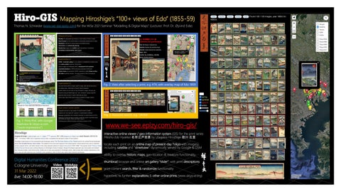
Fig. 2: View after selecting a print, e.g. #74, with overlay map of Edo 1859
Fig. 3: Keyword search, e.g. “shrine” Fig. 1: Print #54, with Google Steetview & Ukiyo-e.com (“more impressions”)
www.we-see.epizy.com/hiro-gis/ interactive online viewer / geo-information system (GIS) for the print series Meisho Edo Hyakkei 名所江戸百景 by Utagawa Hiroshige 歌川 広重 locate each print on an online map of present-day Tokyo with imagery, including satellite and “streetview”, dynamically served by Google & OSM ability to overlay historic maps, geo-location & measure functionality
Digital Humanities Conference 2022 Cologne University Video WebApp 31 Mar 2022 live: 14:00-16:00
thumbnail browser and online art gallery “slider”, with print descriptions print content search, filter & randomize functionality hyperlinks to further explanations & other online prints (www.ukiyo-e.org)